Training program on Modelling: A Case study Hydro-dynamic Model of Zanzibar channel
|
|
|
- Simon Paul
- 5 years ago
- Views:
Transcription
1 Training program on Modelling: A Case study Hydro-dynamic Model of Zanzibar channel Mayorga-Adame,C.G., Sanga,I.P.L., Majuto, C., Makame, M.A., Garu,M.

2 INTRODUCTION Hydrodynamic Modeling In understanding the marine and coastal environment the contribution of hydrodynamic numerical models become highly indispensable. Water quality, sediment transport and ecology models all rely heavily on the results of the hydrodynamic simulations (water levels, horizontal & vertical velocities, salinity, temperature, density pattern etc). At the same time feedback loops exist; the ecology influences the water quality and the hydrodynamics.
3 INTRODUCTION (Cont.) The main goal of the hydrodynamic modeling is to provide the state of the art and accurate simulation for seeking the solutions for challenges present in marine and coastal environment.
4 Beneficiaries Research institutions such as IMS, TAFIRI Commission of Tourism (for management of beaches and hotels along the coast) Port Authorities (Dsm & Zanzibar) Department of environment Department of fisheries (egg and larval transport) Municipal councils Department of lands Oil exploration (for rigs) Other scientist and stakeholders Local communities
 is a freesurface model that solves the")

5 What is ROMS? The Regional Ocean Model System (ROMS) is a freesurface model that solves the hydrostatic primitive equations. It uses stretched, terrainfollowing coordinates in the vertical and orthogonal curvilinear coordinates in the horizontal. It was developed by Rutgers University and is broadly used in sciences worldwide.
6 Why ROMS? It is free access software. It is more realistic than other models: It is a 3 dimensional model. Includes complex ocean dynamics. Coriolis effects Friction Heat fluxes Vertical Mixing Atmospheric and oceanographic features can be included: Temperature and salinity fields Winds Tide Mesoescale currents Rainfall River inputs Biological systems and sediment transport dynamics can be coupled to the hydrodynamic model.
7 Why ROMS? (Cont.) It allows you to assess the different physical processes that are going on in the ocean, individually. Results are quite accurate, and reproduces the most important features of ocean circulation and hydrodynamics of the study area even using a semi-idealized application.
8 The difficult of using ROMS It is as complex as the ocean itself It runs in Linux operating system. It doesn t have a graphical user inter-phase. It can not be used as a black box or a plug and play model. A deep understanding of ocean dynamics and modeling is needed to configure the model. Knowledge about the local oceanographic features affecting the area of study are also required. It doesn t work with default values. Real data is required. Format of input and output files. NetCDF (binary files). Skills in different software are needed for data treatment and results analysis (matlab, Linux, fortran, etc).
9 Objectives To build capacity of modeling team at IMS. To develop a Local Semi-idealized Model of Zanzibar Channel.
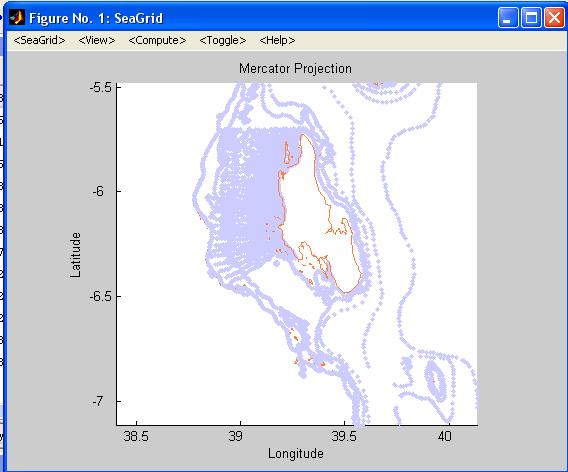
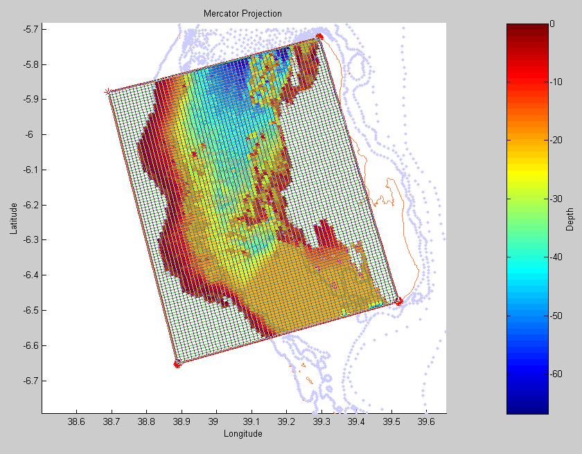
10 Case of study Zanzibar channel located between longitude 38.8 o E 39.6 o E and latitude 5.5 o S 6.8 o S. (the coasts of Tanzania mainland and that of Unguja Island) Zanzibar channel Unguja Island Pemba Island The length of the channel is about 120Km and 35 40Km wide Zanzibar channel
11 Methodology Data collection: Bathymetry and coast line data from global data bases. Local bathymetry data Wind Tides Oceanographic parameters Current (for validation of the model). Data analysis and processing. Preparation of input files Configuration ROMS for the Zanzibar Channel. Analysis of the results and validation of the results.
 GIS laboratory data base (Kombo) Digitize from nautical charts (Dr.")
12 Data analysis and processing Local bathymetry data. Direct measurement (Dr. Shagude) GIS laboratory data base (Kombo) Digitize from nautical charts (Dr. Dubi)
13 Data analysis and processing (cont.) Winds Monthly averages of wind data (speed and direction) for 10 years ( ) from Zanzibar airport meteorological station. N Morning Afternoon 5 m/s month
 Tide Topex/Poseidon global co-tidal map for the component M2")

14 Data analysis and processing (cont.) Tide Topex/Poseidon global co-tidal map for the component M2 shows that the tide is coming in through the southern mouth of the channel. There is information of more complex local tide dynamics (Shaghude et al, 2002).
 (M h p t d e -100-150 -200-250 12 14 16 18 20 22 24 26 28 temperature(oc) Salinity variation with depth 0 station 061 station 067-50 ) (M h p t d e -100-150 -200-250 34.")
15 Data analysis and processing (cont.) Oceanographic parameters CTD casts near the Zanzibar Channel from a Western Indean Ocean Oceanographic Cruiser (Dr. Shaghude). 0 station 061 station ) (M h p t d e temperature(oc) Salinity variation with depth 0 station 061 station ) (M h p t d e salinity

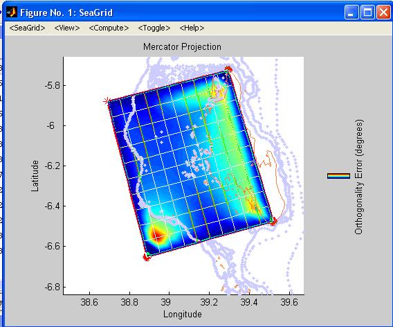
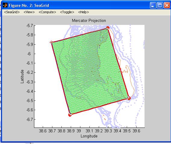
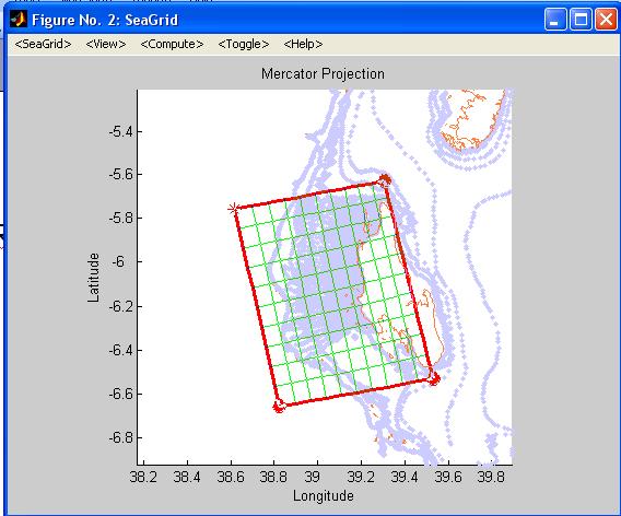
16 Creation of grid file Preparation of input files


17 Preparation of input files (cont.) roms_grd.nc Position of the grid points Size of the grid cells Bottom topography Land mask Bathymetry distribution along the Zanzibar channel
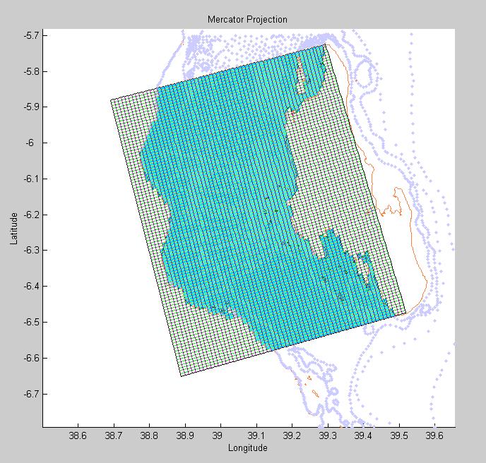
18 Configuration of ROMS for the Zanzibar Channel. 60 x 100 cells covering 72.4 x 88.4 km 16 levels in the vertical. Resolution ~ 1km2 Minimum depth 2 m. Maximum depth 66 m Time step 100 sec. North and South boundaries open. Oceanographic parameters Salinity 34.9 oo /o Temperature 26 o C Density 1023 Kg/m3
19 Configuration of ROMS for the Zanzibar Channel (cont.) Analytical Forcing Wind It was establish as a surface momentum flux uniform over all the domain. The wind stress was calculated based on the magnitude of the wind velocity components. A linear ramp was use to increase wind magnitude from zero to its maximum during the first 2 days modeled, after this wind remain constant over time. The two more common wind condition in the zone were reproduced SE and NE Tide winds. Was establish as a sea level perturbation at the South open boundary, with the frequency of the M2 component (12.42 hrs), and an amplitude of 1 m. The model it self propagate the perturbation Northward along the domain.
20 Running the model We run the model until it gets to stable state. The intermediate states skipped spin up that considered to be not valid results. 10 days of simulation for wind = 1hr and 35 min computing time 5 days of simulation for tide = 20 min computing time

21 SE wind (July) Results In the south part of the Island the surface velocity vectors follow the wind direction. Minimal velocities are found a bit southern than Zanzibar town, due to deflection caused by the tip of Fumba peninsula. From there to the north tip of the island the current have a predominant westward component. The stronger surface (27cm/s) and bottom (16cm/s) velocities are found around Tumbatu island and along the coast of mainland, where the vectors align following the shape of the coast showing a northward current. Bottom velocity vectors follow the shape of the coast in both sides of the channel but point southward along the coast of Zanzibar island and northward along mainland coast.


22 Results SE wind (July) The sea surface elevation shows a longitudinal gradient towards the coast of mainland of 5 cm. The water is piling up towards the coast of mainland due to the sum of the wind effort in the x axes and coriolis effect. Upwelling conditions can be expected along the coast of Zanzibar Island under this wind condition.

23 Results NE wind (January) North East wind generates southward surface currents (30 cm/s) along both coasts of the channel. Slower velocities are found in the central part of the Channel and in front of Zanzibar Town where the southward surface current is deviated to the west due to the morphology of the coast and the presence of shallow reef patch's and small islands. Bottom current flow southward along both coasts of the Channel and northward in the center of it. Topography has a strong effect over the bottom current, generating two eddies turning clockwise, that meet in front of Zanzibar town.


24 Results NE wind (January) Sea surface elevation shows a variation of 1.5 cm, water accumulates towards the south mouth of the channel and the west coast. There is no evidence of upwelling condition along the mainland coast. The influence of the morphology of the coast is stronger than the coriolis effect under this wind conditions.

25 Results Semi-diurnal (M2) tide coming in through the southern mouth. Sea surface elevation.

26 Results Semi-diurnal (M2) tide coming in through the southern mouth. Velocity vectors.

27 Results Semi-diurnal (M2) tide coming in through the southern mouth. Residual vertically integrated velocities. An overall northward flux all along the channel is observed. High speed velocities up to ~4 m/s are observed in punctual locations along the coast of Zanzibar due to reflection caused by morphological features of the coast line. Tidal forcing generates stronger current velocities (~60 cm/s) than wind forcing (~30cm/s).
28 Further steps Putting all together wind, tide, stratification, and running for long time. Including more local data if available. Validating the results. Developing a mesoescale model with global data to get more realistic forcing fields for the free surface and open boundary conditions. Nest the local model to the mesoescale one.
29 Conclusion We have o A team that is doing well and a building capacity of modeling at IMS will be achieved o Developed a hydrodynamic model of Zanzibar channel. It revealed a number of observations To make a useful model for the stakeholders for use in making decisions o We need to incorporate local measured data of the channel (salinity, temperature, current, etc). o Global data on the Zanzibar channel is not available. o The model should be run for long time. o We also need to validate the model. o The model is very potential and it can be very useful for management, planning and decision making
30 Thank you
Currents measurements in the coast of Montevideo, Uruguay
 Currents measurements in the coast of Montevideo, Uruguay M. Fossati, D. Bellón, E. Lorenzo & I. Piedra-Cueva Fluid Mechanics and Environmental Engineering Institute (IMFIA), School of Engineering, Research
Tidal regime along Vietnam coast under impacts of sea level rise
 VNU Journal of Science, Earth Sciences 28 (2012) 133-139 Tidal regime along Vietnam coast under impacts of sea level rise Tran Thuc, Duong Hong Son* Vietnam Institute of Meteorology, Hydrology and Environment
Coastal Sediment Transport Modeling Ocean Beach & San Francisco Bight, CA
 1 Coastal Sediment Transport Modeling Ocean Beach & San Francisco Bight, CA Honghai Li and Lihwa Lin Engineering Research and Development Center U.S. Army Corps of Engineers Frank Wu, Lisa Andes, and James
Geostrophic and Tidal Currents in the South China Sea, Area III: West Philippines
 Southeast Asian Fisheries Development Center Geostrophic and Tidal Currents in the South China Sea, Area III: West Philippines Anond Snidvongs Department od Marine Science, Chulalongkorn University, Bangkok
LONG WAVES OVER THE GREAT BARRIER REEF. Eric Wolanski ABSTRACT
 LONG WAVES OVER THE GREAT BARRIER REEF by Eric Wolanski k ABSTRACT Low-frequency forcing of water currents over the continental shelf f Australia is quite strong and should be taken into account when the
Applications of ELCIRC at LNEC
 stratification in the Guadiana estuary tidal propagation in the Óbidos lagoon Lígia Pinto Anabela Oliveira André B. Fortunato 2 O utline Stratification in the Guadiana estuary The Guadiana estuary Objectives
EFFECTS OF WAVE, TIDAL CURRENT AND OCEAN CURRENT COEXISTENCE ON THE WAVE AND CURRENT PREDICTIONS IN THE TSUGARU STRAIT
 EFFECTS OF WAVE, TIDAL CURRENT AND OCEAN CURRENT COEXISTENCE ON THE WAVE AND CURRENT PREDICTIONS IN THE TSUGARU STRAIT Ayumi Saruwatari 1, Yoshihiro Yoneko 2 and Yu Tajima 3 The Tsugaru Strait between
Ocean Circulation. Si Hui Lee and Frances Wen. You can access ME at
 Ocean Circulation Si Hui Lee and Frances Wen You can access ME at http://tinyurl.com/oceancirculation Earth - the blue planet - 71% area covered by the oceans - 3/4 of ocean area between 3000-6000m deep
SURFACE CURRENTS AND TIDES
 NAME SURFACE CURRENTS AND TIDES I. Origin of surface currents Surface currents arise due to the interaction of the prevailing wis a the ocean surface. Hence the surface wi pattern (Figure 1) plays a key
Modelling study of the dispersal of pollutants at SHo Jacinto submarine outfall (Aveiro, Portugal)
") Modelling study of the dispersal of pollutants at SHo Jacinto submarine outfall (Aveiro, Portugal) M. Ramosl, M. Almeidal, P. Silval, J. Dubertl & J. Antunes do Carrno2 l Department of Physics, University
Modelling study of the dispersal of pollutants at SHo Jacinto submarine outfall (Aveiro, Portugal) M. Ramosl, M. Almeidal, P. Silval, J. Dubertl & J. Antunes do Carrno2 l Department of Physics, University
DUXBURY WAVE MODELING STUDY
 DUXBURY WAVE MODELING STUDY 2008 Status Report Duncan M. FitzGerald Peter S. Rosen Boston University Northeaster University Boston, MA 02215 Boston, MA 02115 Submitted to: DUXBURY BEACH RESERVATION November
SIO 210 Problem Set 3 November 4, 2011 Due Nov. 14, 2011
 SIO 210 Problem Set 3 November 4, 2011 Due Nov. 14, 2011 1. At 20 N, both the ocean and the atmosphere carry approximately 2 PW of heat poleward, for a total of about 4 PW (see figure). If (at this latitude)
Structure and discharge test cases
 Chapter 28 Structure and discharge test cases 28.1 Introduction Three test case have been implemented to test the performance and applicability of the structures and discharges modules. drythin Simulates
JOURNAL OF GEOPHYSICAL RESEARCH, VOL. 107, NO. C9, 3123, doi: /2000jc000768, 2002
 JOURNAL OF GEOPHYSICAL RESEARCH, VOL. 107, NO. C9, 3123, doi:10.1029/2000jc000768, 2002 A modeling study of shelf circulation off northern California in the region of the Coastal Ocean Dynamics Experiment:
Impact of the tides, wind and shelf circulation on the Gironde river plume dynamics
 Impact of the tides, wind and shelf circulation on the Gironde river plume dynamics F. Toublanc 1, N. Ayoub 2, P. Marsaleix 3, P. De Mey 2 1 CNES/LEGOS 2 CNRS/LEGOS 3 CNRS/LA, Toulouse, France 5th GODAE
An Investigation of the Influence of Waves on Sediment Processes in Skagit Bay
 DISTRIBUTION STATEMENT A. Approved for public release; distribution is unlimited. An Investigation of the Influence of Waves on Sediment Processes in Skagit Bay Geoffrey W. Cowles School for Marine Science
APPENDIX A Hydrodynamic Model Qualicum Beach Waterfront Master Plan
 Page 1 of 21 CLIENT: Town of Qualicum Beach PROJECT: SIGNATURE DATE CONTRIBUTORS : M. Marti Lopez REVIEWED BY : P. St-Germain, EIT APPROVED BY: J. Readshaw, P.Eng ISSUE/REVISION INDEX Issue Details Code
MIKE Release General product news for Marine software products, tools & features. Nov 2018
 MIKE Release 2019 General product news for Marine software products, tools & features Nov 2018 DHI 2012 MIKE 3 Wave FM New advanced phase-resolving 3D wave modelling product A MIKE 3 FM Wave model - why?
Study of Passing Ship Effects along a Bank by Delft3D-FLOW and XBeach1
 Study of Passing Ship Effects along a Bank by Delft3D-FLOW and XBeach1 Minggui Zhou 1, Dano Roelvink 2,4, Henk Verheij 3,4 and Han Ligteringen 2,3 1 School of Naval Architecture, Ocean and Civil Engineering,
Available online at ScienceDirect. Procedia Engineering 116 (2015 )
") Available online at www.sciencedirect.com ScienceDirect Procedia Engineering 116 (2015 ) 320 325 8th International Conference on Asian and Pacific Coasts (APAC 2015) Department of Ocean Engineering, IIT
Available online at www.sciencedirect.com ScienceDirect Procedia Engineering 116 (2015 ) 320 325 8th International Conference on Asian and Pacific Coasts (APAC 2015) Department of Ocean Engineering, IIT
Are Advanced Wind Flow Models More Accurate? A Test of Four Models
 Are Advanced Wind Flow Models More Accurate? A Test of Four Models Philippe Beaucage, PhD Senior Research Scientist Michael C. Brower, PhD Chief Technical Officer Brazil Wind Power Conference 2012 Albany
Monitoring tidal movements in Cook Inlet, Alaska, using the integration of remote sensing data, GIS, and inundation models
 Monitoring tidal movements in Cook Inlet, Alaska, using the integration of remote sensing data, GIS, and inundation models Hua Liu Department of political Science and Geography Old Dominion University
JOURNAL OF GEOPHYSICAL RESEARCH, VOL. 107, NO. C11, 3184, doi: /2001jc001190, 2002
 JOURNAL OF GEOPHYSICAL RESEARCH, VOL. 107, NO. C11, 3184, doi:10.1029/2001jc001190, 2002 A modeling study of shelf circulation off northern California in the region of the Coastal Ocean Dynamics Experiment
Waves Part II. non-dispersive (C g =C)
") Waves Part II Previously we discussed Surface Gravity Waves Deep Water Waves Shallow Water Waves C g T 2 C g h dispersive (C g =C/2) Definitions: phase speed C= /T= /k non-dispersive (C g =C) group speed
Waves Part II Previously we discussed Surface Gravity Waves Deep Water Waves Shallow Water Waves C g T 2 C g h dispersive (C g =C/2) Definitions: phase speed C= /T= /k non-dispersive (C g =C) group speed
Three-dimensional High-resolution Numerical Study of the Tide and Tidal Current in the Jiaozhou Bay and Olympic Sailing Site
 Three-dimensional High-resolution Numerical Study of the Tide and Tidal Current in the Jiaozhou Bay and Olympic Sailing Site By Jinrui Chen Ocean University of China cooperator: Shiliang Shan, Huaming
State Estimation of the California Current System Using 4DVar Ocean Data Assimilation
 State Estimation of the California Current System Using 4DVar Ocean Data Assimilation Hajoon Song, Arthur J. Miller and Bruce Cornuelle Scripps Institution of Oceanography, UCSD International Workshop
STUDY ON TSUNAMI PROPAGATION INTO RIVERS
 ABSTRACT STUDY ON TSUNAMI PROPAGATION INTO RIVERS Min Roh 1, Xuan Tinh Nguyen 2, Hitoshi Tanaka 3 When tsunami wave propagation from the narrow river mouth, water surface is raised and fluctuated by long
Testing TELEMAC-2D suitability for tsunami propagation from source to near shore
 Testing TELEMAC-2D suitability for tsunami propagation from source to near shore Alan Cooper, Giovanni Cuomo, Sébastien Bourban, Michael Turnbull, David Roscoe HR Wallingford Ltd, Howbery Park, Wallingford,
Clockwise Phase Propagation of Semi-Diurnal Tides in the Gulf of Thailand
 Journal of Oceanography, Vol. 54, pp. 143 to 150. 1998 Clockwise Phase Propagation of Semi-Diurnal Tides in the Gulf of Thailand TETSUO YANAGI 1 and TOSHIYUKI TAKAO 2 1 Research Institute for Applied Mechanics,
Introduction to Oceanography OCE 1001
 Introduction to Oceanography OCE 1001 Lecture Notes Chantale Bégin & Jessica Fry Version 2.1 10. Ocean Circulation (Trujillo, Chapter 7) Major ocean currents are stable and predictable; they have been
Numerical Simulation of Wave Loads on Static Offshore Structures
 Numerical Simulation of Wave Loads on Static Offshore Structures Hrvoje Jasak, Inno Gatin, Vuko Vukčević Wikki Ltd, United Kingdom Faculty of Mechanical Engineering and Naval Architecture University of
6.28 PREDICTION OF FOG EPISODES AT THE AIRPORT OF MADRID- BARAJAS USING DIFFERENT MODELING APPROACHES
 6.28 PREDICTION OF FOG EPISODES AT THE AIRPORT OF MADRID- BARAJAS USING DIFFERENT MODELING APPROACHES Cecilia Soriano 1, Darío Cano 2, Enric Terradellas 3 and Bill Physick 4 1 Universitat Politècnica de
THE WAVE CLIMATE IN THE BELGIAN COASTAL ZONE
 THE WAVE CLIMATE IN THE BELGIAN COASTAL ZONE Toon Verwaest, Flanders Hydraulics Research, toon.verwaest@mow.vlaanderen.be Sarah Doorme, IMDC, sarah.doorme@imdc.be Kristof Verelst, Flanders Hydraulics Research,
RECTIFICATION OF THE MADDEN-JULIAN OSCILLATION INTO THE ENSO CYCLE
 RECTIFICATION OF THE MADDEN-JULIAN OSCILLATION INTO THE ENSO CYCLE By William S. Kessler and Richard Kleeman Journal of Climate Vol.13, 1999 SWAP, May 2009, Split, Croatia Maristella Berta What does give
MIKE 21 Toolbox. Global Tide Model Tidal prediction
 MIKE 21 Toolbox Global Tide Model Tidal prediction MIKE Powered by DHI 2017 DHI headquarters Agern Allé 5 DK-2970 Hørsholm Denmark +45 4516 9200 Telephone +45 4516 9333 Support +45 4516 9292 Telefax mike@dhigroup.com
The Influence of Wind Direction upon Flow along the West Coast of Britain and in the North Channel of the Irish Sea
 JANUARY 2003 DAVIES AND XING 57 The Influence of Wind Direction upon Flow along the West Coast of Britain and in the North Channel of the Irish Sea ALAN M. DAVIES AND JIUXING XING Proudman Oceanographic
Appendix 5: Currents in Minas Basin. (Oceans Ltd. 2009)
") Appendix 5: Currents in Minas Basin (Oceans Ltd. 29) Current in Minas Basin May 1, 28 March 29, 29 Submitted To: Minas Basin Pulp and Power P.O. Box 41 53 Prince Street Hansport, NS, BP 1P by 22, Purdy
Appendix 5: Currents in Minas Basin (Oceans Ltd. 29) Current in Minas Basin May 1, 28 March 29, 29 Submitted To: Minas Basin Pulp and Power P.O. Box 41 53 Prince Street Hansport, NS, BP 1P by 22, Purdy
PHSC 3033: Meteorology Air Forces
 PHSC 3033: Meteorology Air Forces Pressure Gradient P/ d = Pressure Gradient (Change in Pressure/Distance) Horizontal Pressure Gradient Force (PGF): Force due to pressure differences, and the cause of
NTHMP - Mapping & Modeling Benchmarking Workshop: Tsunami Currents
 NTHMP - Mapping & Modeling Benchmarking Workshop: Tsunami Currents Ahmet Cevdet Yalçıner, Andrey Zaytsev, Utku Kanoğlu Deniz Velioglu, Gozde Guney Dogan, Rozita Kian, Naeimeh Shaghrivand, Betul Aytore
Sea and Land Breezes METR 4433, Mesoscale Meteorology Spring 2006 (some of the material in this section came from ZMAG)
") Sea and Land Breezes METR 4433, Mesoscale Meteorology Spring 2006 (some of the material in this section came from ZMAG) 1 Definitions: The sea breeze is a local, thermally direct circulation arising from
Sea and Land Breezes METR 4433, Mesoscale Meteorology Spring 2006 (some of the material in this section came from ZMAG) 1 Definitions: The sea breeze is a local, thermally direct circulation arising from
Modeling changes to the historic Lower Columbia River Estuary using Delft3D. Drew Mahedy Lumas Helaire Stefan Talke David Jay May 30, 2014
 Modeling changes to the historic Lower Columbia River Estuary using Delft3D Drew Mahedy Lumas Helaire Stefan Talke David Jay May 30, 2014 Comparison: Historic and Modern LCRE US Coastal Survey, 1868 Historic
Ocean Layers. Based on sunlight penetration: Based on water density: Sunlight (photosynthesis is possible) Twilight Midnight
 Twilight Midnight") PART 3 Ocean Layers Based on sunlight penetration: Sunlight (photosynthesis is possible) Twilight Midnight Based on water density: Mixed layer Pycnocline (rapid change of themperature/salinity) Deep ocean
PART 3 Ocean Layers Based on sunlight penetration: Sunlight (photosynthesis is possible) Twilight Midnight Based on water density: Mixed layer Pycnocline (rapid change of themperature/salinity) Deep ocean
MODELLING WAVE-TIDE INTERACTIONS AT A WAVE FARM IN THE SOUTHWEST OF ENGLAND
 MODELLING WAVE-TIDE INTERACTIONS AT A WAVE FARM IN THE SOUTHWEST OF ENGLAND Raúl González-Santamaría 1, Qingping Zou 1, Shunqi Pan 1, Roberto Padilla-Hernandez 2 The Wave Hub project will create the world
Week 6-7: Wind-driven ocean circulation. Tally s book, chapter 7
 Week 6-7: Wind-driven ocean circulation Tally s book, chapter 7 Recap so far Our goal (since week 3) has been to understand large-scale ocean circulation and its underlying physics, and to learn how to
Upstream environment for SBI - Modeled and observed biophysical conditions in the northern Bering Sea
 Upstream environment for SBI - Modeled and observed biophysical conditions in the northern Bering Sea Jaclyn Clement 1, Wieslaw Maslowski 1, Lee Cooper 2, Jacqueline Grebmeier 2, Waldemar Walczowski 3,
ATS 351, Spring 2009 Week 10, Lab #8 due April 2 nd What Makes the Wind Blow? - 60 points Please show your work for calculations.
 ATS 351, Spring 2009 Week 10, Lab #8 due April 2 nd What Makes the Wind Blow? - 60 points Please show your work for calculations. Question #1: Sea Level Pressure (10 points) a) (4 points) How does sea-level
Tides. Tides: longest waves. or seas. or ripples
 Tides or ripples or seas Tides: longest waves Tides Definition: The rise and fall of sea level due to the gravitational forces of the Moon and Sun and the rotation of the Earth. Why tides are important?
The Coriolis force, geostrophy, Rossby waves and the westward intensification
 Chapter 3 The Coriolis force, geostrophy, Rossby waves and the westward intensification The oceanic circulation is the result of a certain balance of forces. Geophysical Fluid Dynamics shows that a very
Chapter 22, Section 1 - Ocean Currents. Section Objectives
 Chapter 22, Section 1 - Ocean Currents Section Objectives Intro Surface Currents Factors Affecting Ocean Currents Global Wind Belts (you should draw and label a diagram of the global wind belts) The Coriolis
Section 6. The Surface Circulation of the Ocean. What Do You See? Think About It. Investigate. Learning Outcomes
 Chapter 5 Winds, Oceans, Weather, and Climate Section 6 The Surface Circulation of the Ocean What Do You See? Learning Outcomes In this section, you will Understand the general paths of surface ocean currents.
SEASONDE DETECTION OF TSUNAMI WAVES
 SEASONDE DETECTION OF TSUNAMI WAVES Belinda Lipa, John Bourg, Jimmy Isaacson, Don Barrick, and Laura Pederson 1 I. INTRODUCTION We here report on preliminary results of a study to assess the capability
Gravity waves in stable atmospheric boundary layers
 Gravity waves in stable atmospheric boundary layers Carmen J. Nappo CJN Research Meteorology Knoxville, Tennessee 37919, USA Abstract Gravity waves permeate the stable atmospheric planetary boundary layer,
Agronomy 406 World Climates
 Agronomy 406 World Climates January 30, 2018 Monsoons. Ocean properties and circulation. Review for today: Online textbook: 1.3.1 (Sea water) Composition and properties. For Thursday: Rahmstorf, S.: The
(20 points) 1. ENSO is a coupled climate phenomenon in the tropical Pacific that has both regional and global impacts.
 1. ENSO is a coupled climate phenomenon in the tropical Pacific that has both regional and global impacts.") SIO 210 Problem Set 4 Answer key December 1, 2014 Due Dec. 12, 2014 (20 points) 1. ENSO is a coupled climate phenomenon in the tropical Pacific that has both regional and global impacts. (2 points) a)
SIO 210 Problem Set 4 Answer key December 1, 2014 Due Dec. 12, 2014 (20 points) 1. ENSO is a coupled climate phenomenon in the tropical Pacific that has both regional and global impacts. (2 points) a)
MODELING INDIAN OCEAN CIRCULATION: BAY OF BENGAL FRESH PLUME AND ARABIAN SEA MINI WARM POOL
 MODELING INDIAN OCEAN CIRCULATION: BAY OF BENGAL FRESH PLUME AND ARABIAN SEA MINI WARM POOL P. N. Vinayachandran* 1 1, *2 and J. Kurian* * 1 Centre for Atmospheric and Oceanic Sciences, Indian Institute
Windcube FCR measurements
 Windcube FCR measurements Principles, performance and recommendations for use of the Flow Complexity Recognition (FCR) algorithm for the Windcube ground-based Lidar Summary: As with any remote sensor,
Numerical modeling of refraction and diffraction
 Numerical modeling of refraction and diffraction L. Balas, A. inan Civil Engineering Department, Gazi University, Turkey Abstract A numerical model which simulates the propagation of waves over a complex
Preliminary Wake Wash Impact Analysis Redwood City Ferry Terminal, Redwood City, CA
 Technical Memorandum Preliminary Wake Wash Impact Analysis Redwood City Ferry Terminal, Redwood City, CA 1. Introduction The following preliminary wake wash impact analysis was initiated by the Port of
Wind Regimes 1. 1 Wind Regimes
 Wind Regimes 1 1 Wind Regimes The proper design of a wind turbine for a site requires an accurate characterization of the wind at the site where it will operate. This requires an understanding of the sources
Lecture Outlines PowerPoint. Chapter 15 Earth Science, 12e Tarbuck/Lutgens
 Lecture Outlines PowerPoint Chapter 15 Earth Science, 12e Tarbuck/Lutgens 2009 Pearson Prentice Hall This work is protected by United States copyright laws and is provided solely for the use of instructors
Wave energy converter effects on wave and sediment circulation
 Wave energy converter effects on wave and sediment circulation Grace Chang and Craig Jones Integral Consulting Inc. cjones@integral-corp.com; gchang@integral-corp.com Jesse Roberts, Kelley Ruehl, and Chris
Observations and Modeling of Coupled Ocean-Atmosphere Interaction over the California Current System
 Observations and Modeling of Coupled Ocean-Atmosphere Interaction over the California Current System Cape Blanco Dudley Chelton 1, Xin Jin 2, Jim McWilliams 2 & Tracy Haack 3 1 Oregon State University
Ocean Currents that Redistribute Heat Globally
 Ocean Currents that Redistribute Heat Globally Ocean Circulation Ocean Currents Fig. CO7 OCEAN CURRENTS Surface ocean currents are similar to wind patterns: 1. Driven by Coriolis forces 2. Driven by winds
The Various Components of the Circulation in the Singapore Strait Region: Tidal, Wind and Eddy-driven Circulations and Their Relative Importance
 The Various Components of the Circulation in the Singapore Strait Region: Tidal, Wind and Eddy-driven Circulations and Their Relative Importance Haoliang Chen CENSAM, Singapore-MIT Alliance for Research
Exploring Localized Mixing Dynamics During Wet Weather in a Tidal Fresh Water System
 Exploring Localized Mixing Dynamics During Wet Weather in a Tidal Fresh Water System Ramona McCullough & Phil Duzinski Delaware Estuary Science & Environmental Summit January 27, 2015 Background and objectives
SIO 210 MIDTERM, 26 October 2009.
 SIO 210 MIDTERM, 26 October 2009. Please mark your answers on the attached answer sheet, and turn in ONLY THE ANSWER SHEET. Donʼt forget to put your name on the answer sheet!! Here are some constants,
ISOLATION OF NON-HYDROSTATIC REGIONS WITHIN A BASIN
 ISOLATION OF NON-HYDROSTATIC REGIONS WITHIN A BASIN Bridget M. Wadzuk 1 (Member, ASCE) and Ben R. Hodges 2 (Member, ASCE) ABSTRACT Modeling of dynamic pressure appears necessary to achieve a more robust
The Surface Currents OCEA 101
 The Surface Currents OCEA 101 Why should you care? - the surface ocean circulation controls the major ocean biomes - variations in ocean circulation control the supply of nutrients for marine organisms
Temperature, salinity, density, and the oceanic pressure field
 Chapter 2 Temperature, salinity, density, and the oceanic pressure field The ratios of the many components which make up the salt in the ocean are remarkably constant, and salinity, the total salt content
The ocean water is dynamic. Its physical
 CHAPTER MOVEMENTS OF OCEAN WATER The ocean water is dynamic. Its physical characteristics like temperature, salinity, density and the external forces like of the sun, moon and the winds influence the movement
13. TIDES Tidal waters
 Water levels vary in tidal and non-tidal waters: sailors should be aware that the depths shown on the charts do not always represent the actual amount of water under the boat. 13.1 Tidal waters In tidal
Announcements. Project 2 due Nov 7 th Topics for today: Big waves. Tsunamis, seiches and tidal waves. Tsunamis and seiches
 Announcements Project 2 due Nov 7 th Topics for today: Big waves Tsunamis, seiches and tidal waves Tsunamis and seiches Seiche: standing wave that rocks back and forth within an enclosed or semi-enclosed
Unsteady Wave-Driven Circulation Cells Relevant to Rip Currents and Coastal Engineering
 Unsteady Wave-Driven Circulation Cells Relevant to Rip Currents and Coastal Engineering Andrew Kennedy Dept of Civil and Coastal Engineering 365 Weil Hall University of Florida Gainesville, FL 32611 phone:
The construction of Deepwater Navigation Channel (DNC) in the Bystry arm of the Danube Delta has started in The whole project provides the
 in the Bystry arm of the Danube Delta has started in The whole project provides the") Annex 45 Numerical Studies of Waves, Currents and Sediment Transport at the Marine Part of Deepwater Navigation Channel through the Bystry Arm of the Danube Delta and Model Verification based on Laboratory
Annex 45 Numerical Studies of Waves, Currents and Sediment Transport at the Marine Part of Deepwater Navigation Channel through the Bystry Arm of the Danube Delta and Model Verification based on Laboratory
An experimental study of internal wave generation through evanescent regions
 An experimental study of internal wave generation through evanescent regions Allison Lee, Julie Crockett Department of Mechanical Engineering Brigham Young University Abstract Internal waves are a complex
An Investigation of the Influence of Waves on Sediment Processes in Skagit Bay
 DISTRIBUTION STATEMENT A. Approved for public release; distribution is unlimited. An Investigation of the Influence of Waves on Sediment Processes in Skagit Bay Geoffrey W. Cowles School for Marine Science
We are long-time and intensive users of COPERNICUS products
 Prevention of river flooding in the French Roussillon Mediterranean Coast SIROCCO academic research group, Laboratoire d Aérologie, CNRS & Toulouse University, France We are long-time and intensive users
The Usage of Propeller Tunnels For Higher Efficiency and Lower Vibration. M. Burak Şamşul
 The Usage of Propeller Tunnels For Higher Efficiency and Lower Vibration M. Burak Şamşul ITU AYOC 2014 - Milper Pervane Teknolojileri Company Profile MILPER is established in 2011 as a Research and Development
A STUDY ON TYPHOONS INDUCED NEARSHORE HYDRODYNAMICS ALONG KINMEN COAST
 A STUDY ON TYPHOONS INDUCED NEARSHORE HYDRODYNAMICS ALONG KINMEN COAST Wen-Son Chiang 1 Wei-Shiun Lu 2 Gia-Yun Chen 3 and Jin-Li Yu 1 Coastal erosion along Liaolo Bay which is a semi-circular beach and
Effect of Hydrodynamics on Sediment Transport near a Coastal Inlet
 ICHE 2014, Hamburg - Lehfeldt & Kopmann (eds) - 2014 Bundesanstalt für Wasserbau ISBN 978-3-939230-32-8 Effect of Hydrodynamics on Sediment Transport near a Coastal Inlet H. Li, M. Brown, J. Rosati & Z.
Presented by. Mr.Danish.D.R. M.Tech Coastal Management Institute for Ocean Management Anna University, Chennai Tamil Nadu, India.
 MATHEMATICAL MODEL STUDY OF THE EFFLUENT DISPOSAL FROM A DESALINATION PLANT IN THE MARINE ENVIRONMENT AT TUTICORIN Presented by Mr.Danish.D.R M.Tech Coastal Management Institute for Ocean Management Anna
GFD1 AS509/OC512 Winter Q Dargan Frierson Lab 6 P.B.Rhines Kelvin Waves and other inertial/gravity waves Tues 7 Feb 12.30
 GFD1 AS509/OC512 Winter Q. 2017 Dargan Frierson Lab 6 P.B.Rhines Kelvin Waves and other inertial/gravity waves Tues 7 Feb 12.30 With this lab we return to wave propagation; succeeding labs will look at
Data Analysis of the Seasonal Variation of the Java Upwelling System and Its Representation in CMIP5 Models
 Data Analysis of the Seasonal Variation of the Java Upwelling System and Its Representation in CMIP5 Models Iulia-Mădălina Ștreangă University of Edinburgh University of Tokyo Research Internship Program
Modeling of Oxygen Injection Experiment in Savannah Harbor
 593 Modeling of Oxygen Injection Experiment in Savannah Harbor S. Davie 1, H. Moorer 2, H. Rodriguez 1, Y. Plis 1 1 Tetra Tech, Inc., 2110 Powers Ferry Road, Suite 202, Atlanta, GA 30339, PH (770) 850-0949;
Chapter 10 Lecture Outline. The Restless Oceans
 Chapter 10 Lecture Outline The Restless Oceans Focus Question 10.1 How does the Coriolis effect influence ocean currents? The Ocean s Surface Circulation Ocean currents Masses of water that flow from one
CHAPTER 6 DISCUSSION ON WAVE PREDICTION METHODS
 CHAPTER 6 DISCUSSION ON WAVE PREDICTION METHODS A critical evaluation of the three wave prediction methods examined in this thesis is presented in this Chapter. The significant wave parameters, Hand T,
Kathleen Dohan. Wind-Driven Surface Currents. Earth and Space Research, Seattle, WA
 Updates to OSCAR and challenges with capturing the wind-driven currents. Wind-Driven Surface Currents Kathleen Dohan Earth and Space Research, Seattle, WA ENSO OSCAR Surface currents from satellite fields
Computational Analysis of Oil Spill in Shallow Water due to Wave and Tidal Motion Madhu Agrawal Durai Dakshinamoorthy
 Computational Analysis of Oil Spill in Shallow Water due to Wave and Tidal Motion Madhu Agrawal Durai Dakshinamoorthy 1 OUTLINE Overview of Oil Spill & its Impact Technical Challenges for Modeling Review
The impact of ocean bottom morphology on the modelling of long gravity waves from tides and tsunami to climate
 The impact of ocean bottom morphology on the modelling of long gravity waves from tides and tsunami to climate Christian Le Provost and Florent Lyard Laboratoire d Etudes en Géophysique et Océanographie
Chapter. The Dynamic Ocean
 Chapter The Dynamic Ocean An ocean current is the mass of ocean water that flows from one place to another. 16.1 The Composition of Seawater Surface Circulation Surface Currents Surface currents are movements
The Air-Sea Interaction. Masanori Konda Kyoto University
 2 The Air-Sea Interaction Masanori Konda Kyoto University 2.1 Feedback between Ocean and Atmosphere Heat and momentum exchange between the ocean and atmosphere Atmospheric circulation Condensation heat
BCCS TECHNICAL REPORT SERIES
 BCCS TECHNICAL REPORT SERIES Numerical studies of internal solitary wave trains generated at edges in the topography. Berntsen, J., Mathisen, J.-P. and Furnes, G. REPORT No. 21 April 13, Report on Contract
IX. Upper Ocean Circulation
 IX. Upper Ocean Circulation World Ocean Covers 71% of Earth s surface Contains 97% of surface water Arctic Ocean NH: 61% ocean, 39% land Pacific Ocean Atlantic Ocean Southern Ocean Indian Ocean SH: 81%
Review of Equivalent Neutral Winds and Stress
 Review of Equivalent Neutral Winds and Stress Mark A. Bourassa Center for Ocean-Atmospheric Prediction Studies, Geophysical Fluid Dynamics Institute & Department of Earth, Ocean and Atmospheric Science
NSF funded project , June 2010-May 2015
 NSF funded project 0961545, June 2010-May 2015 Nested Regional Climate Model (nrcm) update The effect of embedding ROMS in a coastal upwelling zone in CCSM4 R. Justin Small (NCAR), Brian Kauffman (NCAR),
consulting engineers and scientists
 consulting engineers and scientists Coastal Processes Presented by: January 9, 2015 Varoujan Hagopian, P.E. F.ASCE Senior Consultant, Waterfront Engineer Living Shoreline Workshop Lets Remember Why We
CFD for Ballast Water & Bio-fouling Management
 CFD for Ballast Water & Bio-fouling Management Vivek V. Ranade Catalysis, Reactors & Separation Unit (CReST) Chemical Engineering Division National Chemical Laboratory Pune 411008 vv.ranade@ncl.res.in
Nearshore Dredged Material Placement Pilot Study at Noyo Harbor, CA
 1 Nearshore Dredged Material Placement Pilot Study at Noyo Harbor, CA Noyo Cove N 2011 National Conference on Beach Preservation Technology 9-11, February 2011 Lihwa Lin, Honghai Li, Mitchell Brown US
Student name: + is valid for C =. The vorticity
 13.012 Marine Hydrodynamics for Ocean Engineers Fall 2004 Quiz #1 Student name: This is a closed book examination. You are allowed 1 sheet of 8.5 x 11 paper with notes. For the problems in Section A, fill
Anemometry. Anemometry. Wind Conventions and Characteristics. Anemometry. Wind Variability. Anemometry. Function of an anemometer:
 Anemometry Anemometry Function of an anemometer: Measure some or all of the components of the wind vector In homogeneous terrain, vertical component is small express wind as -D horizontal vector For some