Sea Ice Characteristics and Operational Conditions for Ships Working in the Western Zone of the NSR
|
|
|
- Rosamond Evans
- 5 years ago
- Views:
Transcription


1 The Arctic 2030 Project: Feasibility and Reliability of Shipping on the Northern Sea Route and Modeling of an Arctic Marine Transportation & Logistics System 3-rd. Industry Seminar: Sea-Ice & Operational Conditions for Ships on the NSR Sea Ice Characteristics and Operational Conditions for Ships Working in the Western Zone of the NSR Mr. Sergey Balmasov, Head of CHNL s NSR Information Office (sergey@chnl.no) Monday 30 May, 2016, Busan, South-Korea
2 NSR climatic areas The NSR crosses 3 climatic areas: 1. Atlantic region (Barents Sea, western part of Kara Sea and Arctic Basin part placed in the North from Barents and Kara Seas). Here is maximum cyclone frequency, variable weather in winter and cloudy weather, often fog and precipitation in summer. 2. Siberian region (eastern part of Kara Sea, Laptev Sea, western part of East Siberian Sea). Siberian anti-cyclone influences winter in this region. Winter air temperature is lower here that in regions around and almost the same through the whole area. Temperature rises significantly in summer in southern parts of the seas, especially near the coast. In the northern parts of the area temperature remain law in this time. 3. Pacific region (eastern part of East Siberian Sea, Chukchi Sea). Pacific cyclones influence winter strongly. Air temperature is higher, wind strength and precipitation s amount are greater in this region than in the others nearby. Cyclone frequency for the area of cross voyage in the NSR in summer is the highest, large range of temperature. Fog occurs more frequently in the southern part than in the other regions nearby. Among numerous characteristics that reflect weather conditions in Arctic seas are wind, visibility and air temperature. These factors affect navigation directly.

3 NSR climatic areas
4 NSR Climate Air temperature. Abrupt and large variations of air temperature are not common for the region. Period when temperature is above zero along the parallel 75 N is mostly the same, it is 40 days. Maximum temperature in open sea does not exceed 5 C. Temperature increases sometimes very rapidly only in coastal regions of Arctic seas which are warmed up by continent. Fogs. In summer period visibility may get worse because of precipitation, but more often it reduced by fog. There is high fog frequency in summer. Usually fog is not near the shore, but at close ice edge. July and August are the foggiest months. On small islands in the NSR area amount of such foggy days is a bit less (22-24 days per month). Fog usually occurs during sea winds. Wind. Direction, speed, persistence of wind and its rapid increase influence successful navigation directly. Wind is divided into types in accordance with the nature of its effect on drift ice: pushing-off and pushing-to winds. Pushing-off winds facilitate better ice conditions (weaken ice conditions or reject pressure in close ice) in every area of the NSR, pushing-to winds have opposite effect. Along practically the whole NSR, except for certain areas, unfavorable (pushing-to) winds are blowing from the northern quarters. Pushing-to winds usually shift to pushing-off ones or gentle winds during 3 days, sometimes this shifting continues 8 days, in areas that in west and east from Vilkitski Strait and in area of New Siberian Islands this period takes 15 days. Winds with speed of 12 m/s (gusts to 15 m/s) are the most frequent in the highnorth areas of the NSR


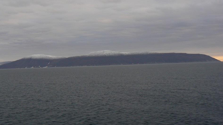
5 Flat costal surface. NSR Climate
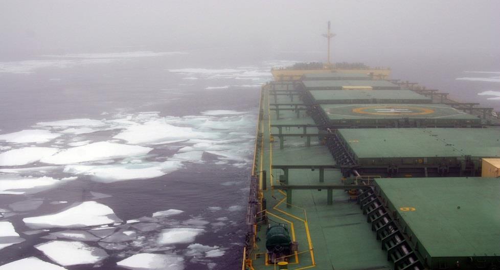
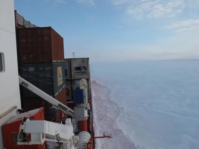
6 Western Zone of the NSR Climat Presence of drifting ice during the whole year Frequent fog and overcast sky Icing of vessels in September December Heating influence of the Barents Sea through Yugorskiy Shar and Kara Gates Straits makes western part of the Sea warmer. The Ob and the Yenisey Rivers also influence the Sea bringing much warm water. Eastern part of the Kara Sea is cooled with the Laptev Sea through Borisa Vilkitskogo and Shokalskogo Straits. Fogs in open sea and on shore are more often in July-August (20-30%). There is low visibility because of fog in July-August (20-35%). Wind currents and flood currents are constant.
7

8 Climat low temperatures in winter period. Presence of drifting ice during the whole year Reduced last decades

9 Icing of vessels in September December Climat


10 Heating influence of the Barents Sea through Yugorskiy Shar and Kara Gates Strait. The Ob and the Yenisey Rivers also influence the Sea bringing much warm water. Eastern part of the Kara Sea is cooled with the Laptev Sea through Borisa Vilkitskogo and Shokalskogo Straits.
.")
11 Fogs in open sea and on shore are more often in July-August (20-30%). Climat

12 Pushing-off and pushing-to winds Climat

13 Low temperatures in winter period. Climat
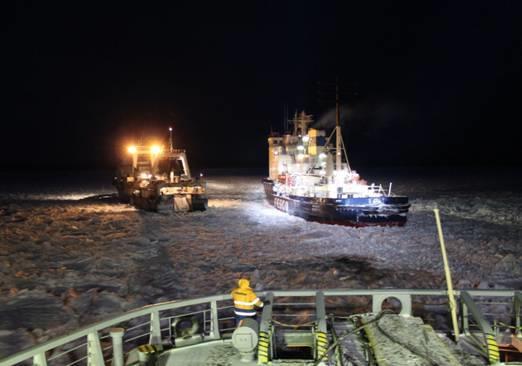
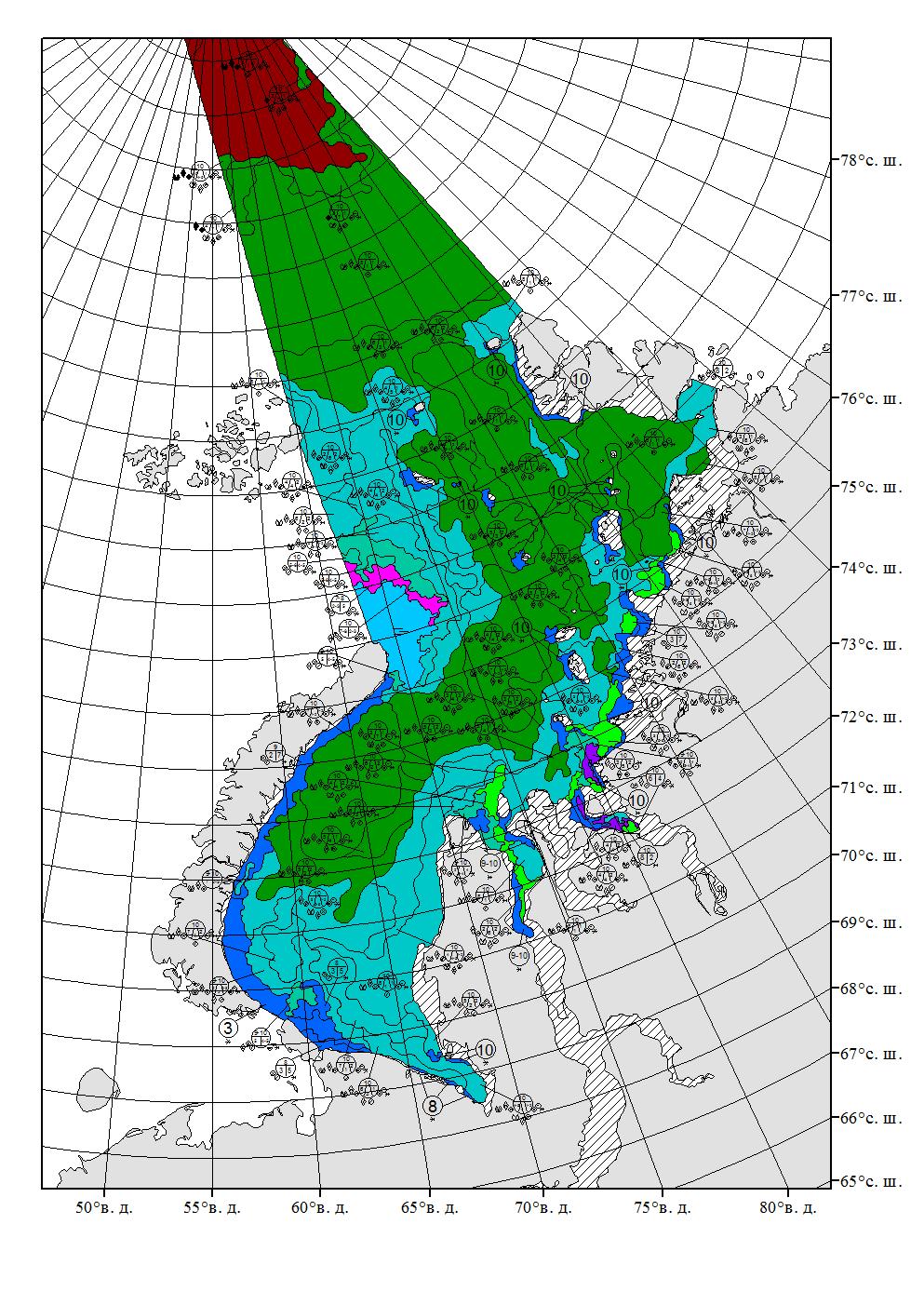
14 Ice conditions There is drifting ice and fast ice of regional origin for the most of a year. Ice formation in north-eastern part starts 15 September among fields of remained ice and expands to south and west In south-west part it starts 20 October, in the Kara Gate and the Yugorskiy Shar in the middle of November In winter under influence of southern wind drifting ice splits off from fast ice edge to north, so flaw polynyas appear. Usually they are covered with young ice. There is active melting in these places in summer. Polynyas are often used for vessel escort in winter. From 1977 year-round navigation has carried out. Particularly dangerous event in winter is ice pressure. The heaviest ice pressure is in coastal regions, near islands and fast ice edge. Length of area with ice pressure can be 5-20 miles, and duration from several minutes to 2-3 days. The causes of ice pressure are wind, strong flood currents. In summer navigation ice is drifting because of wind and current, ice removes to the north and west.

15 Approaches to Kara gate
16 Kara Sea

17 Yenisei river
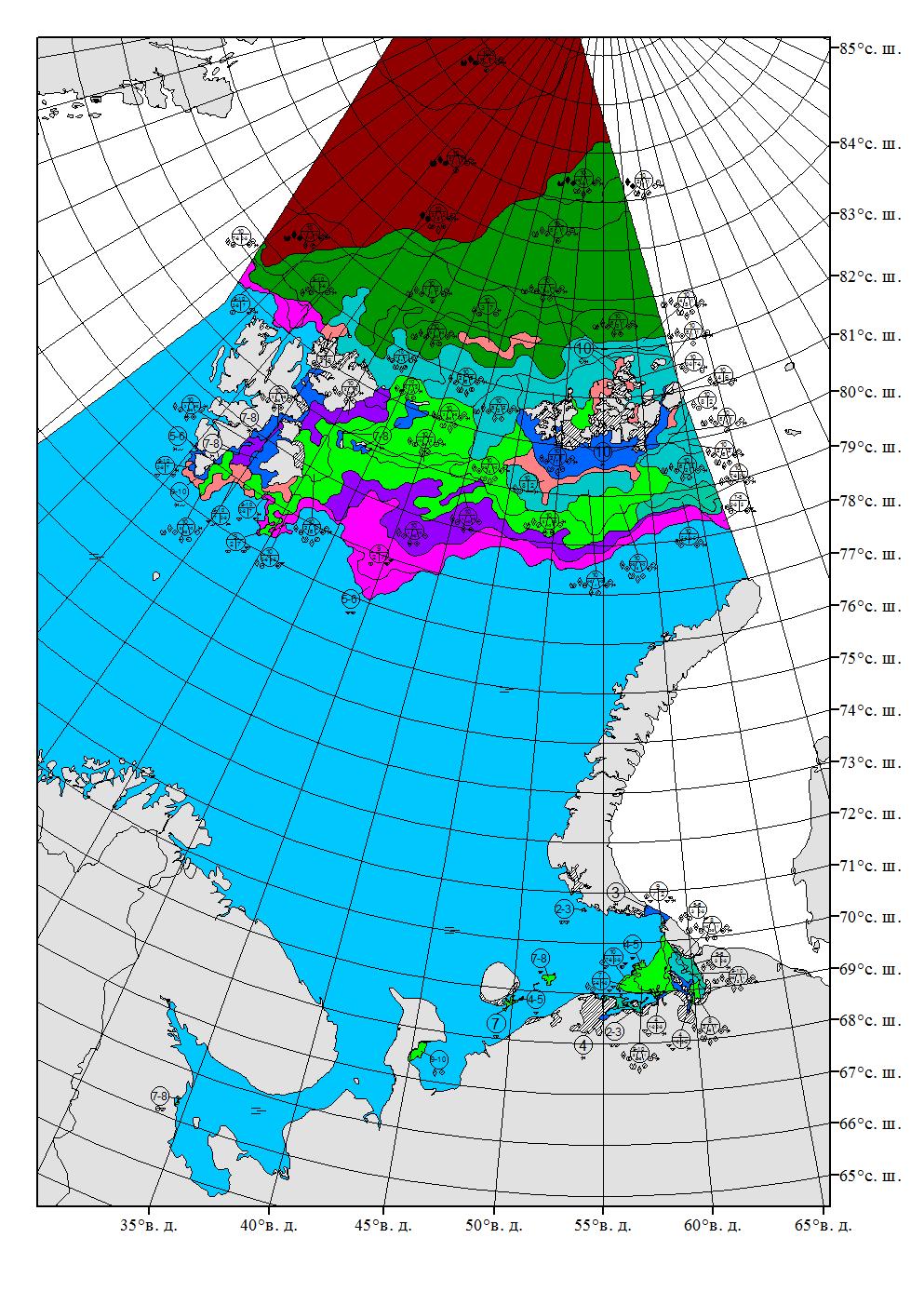
18 Ice conditions In the beginning of summer in the Kara Sea 3 main ice massifs are formed: Novozemelsky, Northern Kara, Severozemelsky Novozemelsky massif is located in the south-western part of the Sea. It consists of oneyear ice and young ice. It can hold a location in the west, in the middle or in the east. It holds western location the most often. Compacted ice borders to the Eastern coast of the Novaya Zemlya Islands and blocks the Kara Gate and the Yugorskiy Shar Straits. Western location of the massif isn t favorable for early start of navigation and vessels passage. There is open ice or ice-free water in the straits when the massif is located in the middle or in the east. Novozemelsky massif can join to Northern Kara when north-eastern wind occurs. The massifs are divided in the end of July at the favorable scenario.
19 Ice conditions Northern Kara massif consists of one-year heavy ice. It is great obstacle for navigation to the Vize Islands. It breaks more slowly than other massifs. Severozemelsky massif is formed when fast ice fractures and it consists of fast ice of regional origin. The massif is located right on the route between Dikson Island and the Boris Vilkitskiy Strait in the Laptev Sea. Ice conditions on western routs to straits of Novaya Zemlya are not serious obstacle for icebreakers and vessels with high ice class. When Novozemelskiy massif is pressed with wind to the Novaya Zemlya, flaw polynyas are formed along the coast. If this massif is located further east than the Severnaya Zemlya, navigation along the coast is complicated. In winter navigation is difficult because of low temperatures and often strong winds, which induce significant ice compacting.
20 The way how to escort a vessel in the beginning of summer period mostly depends on prevailing winds and location of ice fields. Ice river is very dangerous phenomena which happens in autumn and winter. It is intensive drifting line of small ice cake near a border of fast ice or stationary massif that drifts with high speed of high concentrated ice, with compacting of ice and small ice cake in straits, bays and open regions of freezing sea. Ice river can have width up to 1 mile and move with speed up to 5 knots along coast and fast ice edge. Ice river is huge ice mass adjoined to a vessel. A vessel cannot move and an icebreaker cannot assist. Causes of formation: geographic (narrowing in straits, near fast ice in open water, etc.), meteorological (strong wind, temperature s jump or fall), salinity, water density, geophysics (speed up of flood stream, general or local denivellation), calving of fast ice. Forecasting of ice stream is impossible. Ice streams appear everywhere along the NSR. Icing of vessels: occurs during the whole year, but it is dangerous in July-October. Icing is mostly intensive in September-October, dangerous for small size vessels. Low temperature, wind, precipitation. Icing can be very fast (more than 3 cm per hour), fast (1-3cm/hour) or slow (less than 1 cm/hour). Description of ice and hydrometeorological information is contained on 156 pages of Russian pilot books to Arctic Seas.

21 Thank you
Role of ice pilots/navigators on the NSR
 The Arctic 2030 Project: Feasibility and Reliability of Shipping on the Northern Sea Route and Modeling of an Arctic Marine Transportation & Logistics System 1-st Industry Seminar: NSR s Legislation, Tariff
Comments and clarification on existing Russian legislation and regulations for navigation on the NSR. Possible regulatory updates in nearest future.
 The Arctic 2030 Project: Feasibility and Reliability of Shipping on the Northern Sea Route and Modeling of an Arctic Marine Transportation & Logistics System 1-st Industry Seminar: NSR s Legislation, Tariff
ROSATOMFLOT. The Navigation on the Northern Sea Route Today & in the Future
 ROSATOMFLOT The Navigation on the Northern Sea Route Today & in the Future FSUE Atomflot The Fleet On-shore Infrastructure 1278 employees 799 employees Atomic Fleet Special Vessels Atomic Container Carrier
Russian NSR Transit Rules & Regulations. Mr. Sergey Balmasov Head of CHNL s Arctic Logistics Information Office
 Russian NSR Transit Rules & Regulations Mr. Sergey Balmasov Head of CHNL s Arctic Logistics Information Office Current legislation structure United Nations Convention on the Law of the Sea 1982 Article
Current Status of Maritime Infrastructure along the NSR Sergey Balmasov, Head of the CHNL s NSR Information Office in Murmansk
 Current Status of Maritime Infrastructure along the NSR Sergey Balmasov, Head of the CHNL s NSR Information Office in Murmansk sergey@chnl.no 6 th Industry Seminar: NSR s Future Maritime Transportation
Air Masses and Fronts
 Air Masses and Fronts A huge body of air that has similar temperature, humidity, and air pressure at any given height is called an air mass. A single air mass may spread over millions of square kilometers
ROSATOMFLOT. The Navigation on the Northern Sea Route Today & in the Future
 ROSATOMFLOT The Navigation on the Northern Sea Route Today & in the Future Atomic Icebreaking Fleet of Russia Atomic icebreakers of Arktika type: Propulsion Capacity 54 MW; Water displacement 23000 t;
The ocean water is dynamic. Its physical
 CHAPTER MOVEMENTS OF OCEAN WATER The ocean water is dynamic. Its physical characteristics like temperature, salinity, density and the external forces like of the sun, moon and the winds influence the movement
McKnight's Physical Geography 11e
 Chapter 2 Lecture McKnight's Physical Geography 11e Lectures Chapter 5 Atmospheric Pressure and Wind Michael Commons Ohio Northern University Atmospheric Pressure and Wind The Nature of Atmospheric Pressure
Chapter 22, Section 1 - Ocean Currents. Section Objectives
 Chapter 22, Section 1 - Ocean Currents Section Objectives Intro Surface Currents Factors Affecting Ocean Currents Global Wind Belts (you should draw and label a diagram of the global wind belts) The Coriolis
GEOGRAPHY - STD 8 [ ] Q1.
![GEOGRAPHY - STD 8 [ ] Q1.](/thumbs/84/90631870.jpg "GEOGRAPHY - STD 8 [ ] Q1.") GEOGRAPHY - STD 8 Movements of Oceans [2016-2017] Q1. Name the two types of regular movements in the oceans. Ans. The regular movements in the ocean are of two types: 1. Horizontal Ocean currents 2. Vertical
GEOGRAPHY - STD 8 Movements of Oceans [2016-2017] Q1. Name the two types of regular movements in the oceans. Ans. The regular movements in the ocean are of two types: 1. Horizontal Ocean currents 2. Vertical
Chapter 10 Lecture Outline. The Restless Oceans
 Chapter 10 Lecture Outline The Restless Oceans Focus Question 10.1 How does the Coriolis effect influence ocean currents? The Ocean s Surface Circulation Ocean currents Masses of water that flow from one
Lesson: Ocean Circulation
 Lesson: Ocean Circulation By Keith Meldahl Corresponding to Chapter 9: Ocean Circulation As this figure shows, there is a connection between the prevailing easterly and westerly winds (discussed in Chapter
2 Air Masses and Fronts
 CHAPTER 16 2 Air Masses and Fronts SECTION Understanding Weather BEFORE YOU READ After you read this section, you should be able to answer these questions: How is an air mass different from a front? How
Name Date L.O: SWBAT explain what breezes, planetary winds, ocean currents & monsoons are.
 Name Date L.O: SWBAT explain what breezes, planetary winds, ocean currents & monsoons are. 1. A cool breeze is blowing toward the land from the ocean on a warm, cloudless summer day. This condition is
Weather questions. Question 1 (1 Mark) State what information is included in a cyclone warning.
 State what information is included in a cyclone warning.") Question 1 (1 Mark) Weather questions State what information is included in a cyclone warning. Question 2 (1 Mark) In which direction do winds travel around a high pressure system in the southern hemisphere?
Question 1 (1 Mark) Weather questions State what information is included in a cyclone warning. Question 2 (1 Mark) In which direction do winds travel around a high pressure system in the southern hemisphere?
Weather EOG Review Questions
 Weather EOG Review Questions 1. Which statement best describes runoff? A Water vapor cools off and changes into water droplets. B Water in the form of rain, snow, sleet, or hail falls from clouds. C Precipitation
Duckies have been found in Hawaii, Alaska, S. America, Scotland, Washington state and Australia as of 2012.
 Duckies have been found in Hawaii, Alaska, S. America, Scotland, Washington state and Australia as of 2012. We learned that it takes 3 years to complete one circuit of the North Pacific Gyre flow in the
WEATHER SYSTEMS OF MIDDLE LATITUDES
 CHAPTER 10 WEATHER SYSTEMS OF MIDDLE LATITUDES MULTIPLE CHOICE QUESTIONS 1. In equal volumes, which one of the following air masses exerts the highest surface air pressure? a. cp *b. A c. mp d. ct e. mt
MACKENZIE DELTA AND BEAUFORT COAST SPRING BREAKUP NEWSLETTER
 MACKENZIE DELTA AND BEAUFORT COAST SPRING BREAKUP NEWSLETTER Report 2018-16 June 19, 2018 Friends of Steven Solomon (Dustin Whalen, Paul Fraser, Don Forbes) Geological Survey of Canada, Bedford Institute
In comparison to depressions, these can be quite boring, at least in terms of the weather they bring.
 Anticyclones In comparison to depressions, these can be quite boring, at least in terms of the weather they bring. In summary, anticyclones; Are larger than low pressure systems, Last longer than low pressure
The Movement of Ocean Water. Currents
 The Movement of Ocean Water Currents Ocean Current movement of ocean water that follows a regular pattern influenced by: weather Earth s rotation position of continents Surface current horizontal movement
9.3. Storing Thermal Energy. Transferring Thermal Energy
 9.3 If you have been to a beach on a hot summer day, you have likely cooled off by going for a dip in the water. The water, which is cooler than you are, removes thermal energy from your body, making you
4.2 Pressure and Air Masses (6.3.2)
") 4.2 Pressure and Air Masses (6.3.2) Explore This Phenomena www.ck12.org Everybody loves a picnic. Your friends and you are headed up the canyon to enjoy the mountains. While driving you feel a slight discomfort
4.2 Pressure and Air Masses (6.3.2) Explore This Phenomena www.ck12.org Everybody loves a picnic. Your friends and you are headed up the canyon to enjoy the mountains. While driving you feel a slight discomfort
Winds and Ocean Circulations
 Winds and Ocean Circulations AT 351 Lab 5 February 20, 2008 Sea Surface Temperatures 1 Temperature Structure of the Ocean Ocean Currents 2 What causes ocean circulation? The direction of most ocean currents
3 Global Winds and Local Winds
 CHAPTER 15 3 Global Winds and Local Winds SECTION The Atmosphere BEFORE YOU READ After you read this section, you should be able to answer these questions: What causes wind? What is the Coriolis effect?
Warm front and cold front video 3:50
 Construct an explanation of the relationship between air pressure, weather fronts, and air masses and meteorological events such as tornados and thunderstorms Unpacked : Warm front and cold front video
Module 3, Investigation 1: Briefing 1 What are the effects of ENSO?
 Background The changing temperatures of the tropical Pacific Ocean affect climate variability all over Earth. Ocean warming and cooling dramatically affect human activities by changing weather patterns
Climate variability and changes in the marginal Far-Eastern Seas
 PICES-26 November 2-3, 26 San Diego, USA Climate variability and changes in the marginal Far-Eastern Seas Elena I. Ustinova and Yury D. Sorokin Pacific Fisheries Research Centre (TINRO-Centre) 699 Shevchenko
Applied Earth Science Climate Exam Practice Questions Page 1
 Name: 1. Which combination of climate factors generally results in the coldest temperatures? A) low elevation and low latitude B) low elevation and high latitude C) high elevation and low latitude D) high
Seasonal Summary. For The Great Lakes. Winter
 Seasonal Summary For The Great Lakes Winter 2007-2008 Produced by the North American Ice Service August 2008 Table of Contents General General overview of the past season...4 Lake Superior...9 Lake Michigan
Lecture Outlines PowerPoint. Chapter 15 Earth Science, 12e Tarbuck/Lutgens
 Lecture Outlines PowerPoint Chapter 15 Earth Science, 12e Tarbuck/Lutgens 2009 Pearson Prentice Hall This work is protected by United States copyright laws and is provided solely for the use of instructors
REMINDERS: UPCOMING REVIEW SESSIONS: - Thursday, Feb 27, 6:30-8:00pm in HSS 1330
 REMINDERS: Midterm 2: Friday, February 28 - lecture material covering chapters 6, 7, and 15 (since first midterm and through Wed lecture) - same Format as first midterm UPCOMING REVIEW SESSIONS: - Thursday,
Air Pressure and Wind
 Air Pressure and Wind 19.1 Understanding Air Pressure Air Pressure Defined Air pressure is the pressure exerted by the weight of air. Air pressure is exerted in all directions down, up, and sideways. The
Water on Earth. How do oceans relate to weather and the atmosphere? Solar Radiation and Convection Currents
 Earth is often called the Blue Planet because so much of its surface (about 71%) is covered by water. Of all the water on Earth, about 96.5% is held in the world s oceans. As you can imagine, these oceans
What Causes Different Weather?
 What Causes Different Weather? Table of Contents What causes weather?...3 What causes it to rain or snow?...4 What causes flooding?...5 What causes hail?...6 What causes the seasons?...7-8 What causes
Directed Reading. Section: Ocean Currents. a(n). FACTORS THAT AFFECT SURFACE CURRENTS
. FACTORS THAT AFFECT SURFACE CURRENTS") Skills Worksheet Directed Reading Section: Ocean Currents 1. A horizontal movement of water in a well-defined pattern is called a(n). 2. What are two ways that oceanographers identify ocean currents? 3.
Skills Worksheet Directed Reading Section: Ocean Currents 1. A horizontal movement of water in a well-defined pattern is called a(n). 2. What are two ways that oceanographers identify ocean currents? 3.
Chapter. Air Pressure and Wind
 Chapter Air Pressure and Wind 19.1 Understanding Air Pressure Air Pressure Defined Air pressure is the pressure exerted by the weight of air. 19.1 Understanding Air Pressure Air Pressure Defined Air pressure
Assessment Schedule 2016 Earth and Space Science: Demonstrate understanding of processes in the ocean system (91413)
") NCEA Level 3 Earth & Space Science (91413) 2016 page 1 of 6 Assessment Schedule 2016 Earth and Space Science: Demonstrate processes in the ocean system (91413) Evidence Statement Q Evidence with with Excellence
NCEA Level 3 Earth & Space Science (91413) 2016 page 1 of 6 Assessment Schedule 2016 Earth and Space Science: Demonstrate processes in the ocean system (91413) Evidence Statement Q Evidence with with Excellence
8/29/20098 SAHRA - Watershed Visualization
 Module 3 Narration Southwestern Water Cycle 001.wav 26 sec 002.wav 10 sec 003 wav 17 sec Water on Earth is constantly on the move. Water continually circulates between the surface of Earth and the atmosphere
ATS150: Global Climate Change. Oceans and Climate. Icebergs. Scott Denning CSU 1
 The Oceans Wind-Driven Gyre Circulations Icebergs Scott Denning CSU 1 Surface Balance of Forces friction coriolis wind stress resultant current Wind stress accelerates surface water Friction couples surface
Deep Water Currents Lab
 Deep Water Currents Lab Background: Anyone visiting the seashore is struck by the constant motion of water traveling on the surface of the ocean in the form of waves. But beneath the ocean's surface, water
THE ATMOSPHERE. WEATHER and CLIMATE. The Atmosphere 10/12/2018 R E M I N D E R S. PART II: People and their. weather. climate?
 R E M I N D E R S Two required essays are due by Oct. 30, 2018. (A third may be used for extra credit in place of a Think Geographically essay.) ESSAY TOPICS (choose any two): Contributions of a noted
UNIT 1: WATER SYSTEMS ON EARTH CHAPTER 3
 UNIT 1: WATER SYSTEMS ON EARTH CHAPTER 3 HEAT CAPACITY HEAT CAPACITY (SPECIFIC HEAT CAPACITY) IS THE AMOUNT OF HEAT THAT A SUBSTANCE CAN HOLD WATER HAS A HIGH HEAT CAPACITY IT CAN TAKE IN A LARGE AMOUNT
Ocean Motion Notes. Chapter 13 & 14
 Ocean Motion Notes Chapter 13 & 14 What is a Wave? Wave: movement of energy through a body of water How are Waves Caused? Caused mostly by wind Wind blowing on the water transmits energy to the water Size
Explain List Describe Compare Identify
 Objective:S.W.A.B.T. Explain how an air mass forms. List the four main types of air masses. Describe how air masses affect the weather of North America. Compare the characteristic weather patterns of cold
Section 6. The Surface Circulation of the Ocean. What Do You See? Think About It. Investigate. Learning Outcomes
 Chapter 5 Winds, Oceans, Weather, and Climate Section 6 The Surface Circulation of the Ocean What Do You See? Learning Outcomes In this section, you will Understand the general paths of surface ocean currents.
The Composition of Seawater
 The Composition of Seawater Salinity Salinity is the total amount of solid material dissolved in water. Most of the salt in seawater is sodium chloride, common table salt. Element Percent Element Percent
Pacific Climate Variability
 Pacific Climate Variability Pacific Islands Climate Education Partnership You may have heard the term climate variability. What does the term climate variability mean? What are the causes and effects of
Wind is caused by differences in air pressure created by changes in temperature and water vapor content.
 Topic 8: Weather Notes, Continued Workbook Chapter 8 Wind is caused by differences in air pressure created by changes in temperature and water vapor content. Wind blows from high pressure areas to low
Ocean Motion. Ocean Currents. Before You Read. Read to Learn
 chapter 18 3 Ocean Motion section 2 Ocean Currents What You ll Learn the Coriolis effect what influences surface currents the temperature of coastal waters about density currents Before You Read Imagine
9/25/2014. Scales of Atmospheric Motion. Scales of Atmospheric Motion. Chapter 7: Circulation of the Atmosphere
 Chapter 7: Circulation of the Atmosphere The Atmosphere: An Introduction to Meteorology, 12 th Lutgens Tarbuck Lectures by: Heather Gallacher, Cleveland State University Scales of Atmospheric Motion Small-
Ocean Currents that Redistribute Heat Globally
 Ocean Currents that Redistribute Heat Globally Ocean Circulation Ocean Currents Fig. CO7 OCEAN CURRENTS Surface ocean currents are similar to wind patterns: 1. Driven by Coriolis forces 2. Driven by winds
Currents. History. Pressure Cells 3/13/17. El Nino Southern Oscillation ENSO. Teleconnections and Oscillations. Neutral Conditions
 Teleconnections and Oscillations Teleconnection climate anomalies being related to each other over a large scale Oscillations: Macroscale movement of atmospheric systems that can influence weather, climate,
Zonal (East-West) Currents. Wind-Driven Ocean Currents. Zonal (East-West) Currents. Meridional (N-S) Currents
 Currents. Wind-Driven Ocean Currents. Zonal (East-West) Currents. Meridional (N-S) Currents") Wind-Driven Ocean Currents Similarities between winds & surface currents Zonal (East-West) Currents Trade winds push currents westward north & south of the equator Equatorial currents. Up to 100 cm/sec.
Wind-Driven Ocean Currents Similarities between winds & surface currents Zonal (East-West) Currents Trade winds push currents westward north & south of the equator Equatorial currents. Up to 100 cm/sec.
Chapter 8 Air Masses
 Chapter 8 Air Masses Air Masses - 1 1. An Air Mass is a large body of air usually about 1500 km across and several km thick, that has homogeneous physical properties. 2. The important physical properties
SURFACE CURRENTS AND TIDES
 NAME SURFACE CURRENTS AND TIDES I. Origin of surface currents Surface currents arise due to the interaction of the prevailing wis a the ocean surface. Hence the surface wi pattern (Figure 1) plays a key
100, precipitation Droplets, collide -40 C
 Warm-up 1/8 Page: 556, 1. A cloud droplet must increase in diameter by about times to fall as. 100, precipitation Page: 556, 2. Coalescence is when larger drift downward, then and combine with smaller
Global Circulations. GEOG/ENST 2331 Lecture 15 Ahrens: Chapter 10
 Global Circulations GEOG/ENST 2331 Lecture 15 Ahrens: Chapter 10 Last lecture Microscale (turbulence) Mesoscale (land/sea breeze) Synoptic scale (monsoon) Global scale (3 cell circulation) Three Cell Model
2.2 Southwest Monsoon
 2.2 Southwest Monsoon While many manuals place their discussion of the northeast monsoon first-since it can be associated with January, the first month of the year-the southwest monsoon is presented first
IX. Upper Ocean Circulation
 IX. Upper Ocean Circulation World Ocean Covers 71% of Earth s surface Contains 97% of surface water Arctic Ocean NH: 61% ocean, 39% land Pacific Ocean Atlantic Ocean Southern Ocean Indian Ocean SH: 81%
SIO20 - Midterm Examination 2 v1 Winter Section A. Circle the letter corresponding to the best answer. (1 point each)
") NAME: Section A. Circle the letter corresponding to the best answer. (1 point each) 1. Rainbows result from: a. refraction and reflection of sunlight by water droplets b. reflection of sunlight by oceans
NAME: Section A. Circle the letter corresponding to the best answer. (1 point each) 1. Rainbows result from: a. refraction and reflection of sunlight by water droplets b. reflection of sunlight by oceans
Unit 11 Lesson 2 How Does Ocean Water Move? Copyright Houghton Mifflin Harcourt Publishing Company
 Unit 11 Lesson 2 How Does Ocean Water Move? Catch a Wave A wave is the up-and-down movement of surface water. Catch a Wave Catch a Wave (wave effects) Surface waves are caused by wind pushing against
Earth s oceans covers 71 % _ of the planet s surface. In reality, Earth s ocean waters are all. interconnected as part of a single large global ocean.
 Ocean Motion Met 101: Introduction to the World's Oceans Produced by The COMET Program Geography: Name Pd. Earth s oceans covers 71 % _ of the planet s surface. In reality, Earth s ocean waters are all
Chapter. The Dynamic Ocean
 Chapter The Dynamic Ocean An ocean current is the mass of ocean water that flows from one place to another. 16.1 The Composition of Seawater Surface Circulation Surface Currents Surface currents are movements
MACKENZIE DELTA AND BEAUFORT COAST SPRING BREAKUP NEWSLETTER
 MACKENZIE DELTA AND BEAUFORT COAST SPRING BREAKUP NEWSLETTER Report 2018-07 May 25, 2018 (Friday) Friends of Steven Solomon (Dustin Whalen, Paul Fraser, Don Forbes) Geological Survey of Canada, Bedford
Natural Regions of the World
 Natural Regions of the World Revision for Competitive Exams 10x10learning.com 1 Concept of Natural Regions provides a framework for understanding the diversity of physical and biological environment Taiga
Weather drivers in Victoria
 August 2008 Weather drivers in Victoria Key facts Major weather drivers in Victoria are: El Niño - Southern Oscillation frontal systems cut-off lows blocking highs Southern Annular Mode cloudbands Figure
Canada s vast size creates a diverse range of weather conditions and climatic conditions. Warming trend for last 10 years Wet Spring Dry five summers
 Chapter 4 Weather and Climate Canada s vast size creates a diverse range of weather conditions and climatic conditions. Weather examples: Rainy today Snow tomorrow Fog on Wednesday 23 degree C today High
Class Notes: Week 10. April 9 th,2019. Topics: Front and Mid-Latitude Wave Cyclones El Niño / La Niña Mid-term 2 review
 Class Notes: Week 10 April 9 th,2019 Topics: Front and Mid-Latitude Wave Cyclones El Niño / La Niña Mid-term 2 review Front- is a boundary between 2 different types of air masses Air masses with different
- wet tropical climate
 (1 of 13) Further Reading: Chapter 10 of the text book Outline - wet tropical climate - coastal trade wind climate - wet-dry and monsoon climate - dry tropical climate (2 of 13) Introduction Previously,
3 Global Winds and Local Winds
 CHAPTER 6 3 Global Winds and Local Winds SECTION The Atmosphere BEFORE YOU READ After you read this section, you should be able to answer these questions: What causes wind? What is the Coriolis effect?
Only launch your boat once you have a clear understanding of the most up-to-date weather forecast.
 Weather and Tides Observing the Weather Only launch your boat once you have a clear understanding of the most up-to-date weather forecast. Start with television and newspaper weather map reports; they
Section 1. Global Wind Patterns and Weather. What Do You See? Think About It. Investigate. Learning Outcomes
 Chapter 5 Winds, Oceans, Weather, and Climate Section 1 Global Wind Patterns and Weather What Do You See? Learning Outcomes In this section, you will Determine the effects of Earth s rotation and the uneven
El Niño Lecture Notes
 El Niño Lecture Notes There is a huge link between the atmosphere & ocean. The oceans influence the atmosphere to affect climate, but the atmosphere also influences the ocean, which can also affect climate.
Review for the second quarter. Mechanisms for cloud formation
 Review for the second quarter Mechanisms for cloud formation 1 Rising air expands and cools; Sinking air compresses and warms. (18) (24) Dry adiabatic lapse rate (10 o C/km): the rate of temperature decrease
Equatorial upwelling. Example of regional winds of small scale
 Example of regional winds of small scale Sea and land breezes Note on Fig. 8.11. Shows the case for southern hemisphere! Coastal upwelling and downwelling. Upwelling is caused by along shore winds, that
Agronomy 406 World Climates
 Agronomy 406 World Climates January 30, 2018 Monsoons. Ocean properties and circulation. Review for today: Online textbook: 1.3.1 (Sea water) Composition and properties. For Thursday: Rahmstorf, S.: The
Introduction to Oceanography OCE 1001
 Introduction to Oceanography OCE 1001 Lecture Notes Chantale Bégin & Jessica Fry Version 2.1 10. Ocean Circulation (Trujillo, Chapter 7) Major ocean currents are stable and predictable; they have been
STUDENT PACKET # 10. Vocabulary: condensation, convection, convection current, land breeze, sea breeze
 STUDENT PACKET # 10 Name: Date: Student Exploration: Coastal Winds and Clouds Big Idea 7: Earth Systems and Patterns SC.6.E.7.4 Differentiate and show interactions among the geosphere, hydrosphere, cryosphere,
3 Global Winds and Local Winds
 CHAPTER 1 3 Global Winds and Local Winds SECTION The Atmosphere BEFORE YOU READ After you read this section, you should be able to answer these questions: What causes wind? What is the Coriolis effect?
Man-made Global Warming Impossible Part 3: Arctic Warming Paradox
 Man-made Global Warming Impossible Part 3: Arctic Warming Paradox By Rolf A. F. Witzsche 2013 Published by Cygni Communications Ltd. Canada Click on the images for a larger view Why are the arctic regions
Ocean Circulation. Si Hui Lee and Frances Wen. You can access ME at
 Ocean Circulation Si Hui Lee and Frances Wen You can access ME at http://tinyurl.com/oceancirculation Earth - the blue planet - 71% area covered by the oceans - 3/4 of ocean area between 3000-6000m deep
METEOROLOGICAL GUIDE LA ROUTE DES TAMARINS PWC 2014 REUNION ISLAND
 METEOROLOGICAL GUIDE LA ROUTE DES TAMARINS PWC 2014 REUNION ISLAND From the 14 th to 18 th of November 2008 1. PREVAILING WINDS The Reunion island is situated on the 21 st parallel south. Its climate as
OCEANOGRAPHY STUDY GUIDE
 OCEANOGRAPHY STUDY GUIDE Chapter 2 Section 1 1. Most abundant salt in ocean. Sodium chloride; NaCl 2. Amount of Earth covered by Water 71% 3. Four oceans: What are they? Atlantic, Pacific, Arctic, Indian
Oil spill drift study for NORTHER By V. Dulière and S. Legrand
 October 2011 Oil spill drift study for NORTHER By V. Dulière and S. Legrand 1. Introduction The risk for navigation accident and therefore also for oil spilled at sea increases with the installation of
Global Winds and Local Winds
 Global Winds and Local Winds National Science Education Standards ES 1j What is the Coriolis effect? What are the major global wind systems on Earth? What Causes Wind? Wind is moving air caused by differences
Lornshill Academy. Geography Department Higher Revision Physical Environments - Atmosphere
 Lornshill Academy Geography Department Higher Revision Physical Environments - Atmosphere Physical Environments Atmosphere Global heat budget The earth s energy comes from solar radiation, this incoming
Becky Bolinger NIDIS IMW Drought Early Warning System Webinar November 21, 2017
 NIDIS Intermountain West Dec-Feb Winter Outlook Becky Bolinger NIDIS IMW Drought Early Warning System Webinar November 21, 2017 COLORADO CLIMATE CENTER La Niña Advisory And associated impacts from La Niña
Role of the oceans in the climate system
 Role of the oceans in the climate system heat exchange and transport hydrological cycle and air-sea exchange of moisture wind, currents, and upwelling gas exchange and carbon cycle Heat transport Two Primary
The ice season
 The ice season 2010-2011 Author: Jouni Vainio 1 Co-authors: Patrick Eriksson 1, Natalija Schmelzer 2, Jürgen Holfort 2, Torbjörn Grafström 3, Amund E.B. Lindberg 3, Lisa Lind 3, Jörgen Öberg 3, Andris
Ocean Currents Unit (4 pts)
") Name: Section: Ocean Currents Unit (Topic 9A-1) page 1 Ocean Currents Unit (4 pts) Ocean Currents An ocean current is like a river in the ocean: water is flowing traveling from place to place. Historically,
Name: Section: Ocean Currents Unit (Topic 9A-1) page 1 Ocean Currents Unit (4 pts) Ocean Currents An ocean current is like a river in the ocean: water is flowing traveling from place to place. Historically,
ARCTIC SHIPPING: NAVIGATING THE RISKS AND OPPORTUNITIES
 ARCTIC SHIPPING: NAVIGATING THE RISKS AND OPPORTUNITIES Published: 19-Aug- 2014 Edited by Marsh LLC 1166 Avenue of the Americas New York, NY 10036-2774 Telephone: 212 345-5000 http://usa.marsh.com/newsinsights/marshriskmanagementresearch/id/41590/
APPENDIX G WEATHER DATA SELECTED EXTRACTS FROM ENVIRONMENTAL DATA FOR BCFS VESSEL REPLACEMENT PROGRAM DRAFT REPORT
 APPENDIX G WEATHER DATA SELECTED EXTRACTS FROM ENVIRONMENTAL DATA FOR BCFS VESSEL REPLACEMENT PROGRAM DRAFT REPORT Prepared for: B.C. Ferries Services Inc. Prepared by: George Roddan, P.Eng. Roddan Engineering
Lecture 13. Global Wind Patterns and the Oceans EOM
 Lecture 13. Global Wind Patterns and the Oceans EOM Global Wind Patterns and the Oceans Drag from wind exerts a force called wind stress on the ocean surface in the direction of the wind. The currents
Ocean Layers. Based on sunlight penetration: Based on water density: Sunlight (photosynthesis is possible) Twilight Midnight
 Twilight Midnight") PART 3 Ocean Layers Based on sunlight penetration: Sunlight (photosynthesis is possible) Twilight Midnight Based on water density: Mixed layer Pycnocline (rapid change of themperature/salinity) Deep ocean
PART 3 Ocean Layers Based on sunlight penetration: Sunlight (photosynthesis is possible) Twilight Midnight Based on water density: Mixed layer Pycnocline (rapid change of themperature/salinity) Deep ocean
18.1 Understanding Air Pressure 18.1 Understanding Air Pressure Air Pressure Defined Measuring Air Pressure Air pressure barometer
 18.1 Understanding Air Pressure 18.1 Understanding Air Pressure Air Pressure Defined Air pressure is the pressure exerted by the weight of air. Air pressure is exerted in all directions down, up, and sideways.
The Air-Sea Interaction. Masanori Konda Kyoto University
 2 The Air-Sea Interaction Masanori Konda Kyoto University 2.1 Feedback between Ocean and Atmosphere Heat and momentum exchange between the ocean and atmosphere Atmospheric circulation Condensation heat
Weather drivers in South Australia
 August 2008 Key facts Weather drivers in South Australia Major weather drivers in South Australia are: El Niño - Southern Oscillation frontal systems cut-off lows blocking highs Indian Ocean Dipole cloudbands
Heart of England Offshore Cruising Association HOEOCA
 Sailing Weather Penny Tranter 19 January 2017 Heart of England Offshore Cruising Association HOEOCA Weather and climate The difference between weather and climate? Weather is the state of the atmosphere