Weems & Plath Expanding Square SAR Course Identifier #113
|
|
|
- Thomas Payne
- 5 years ago
- Views:
Transcription
1 Weems & Plath Expanding Square SAR Course Identifier #113 A common search pattern used in search and rescue (SAR) operations is called the expanding square pattern, which is just what it says it is. You travel along calculated route legs in a pattern that expands every 3rd leg so you systematically cover the the search area in an expanding pattern, as shown below. To plan out such a pattern you need to know your (1) initial heading, (2) the distance you want between the squares, (3) your boat speed, and (4) the time you plan to start. In one sense, the next logical step is turn to your electronic charting program, put in the way points, select an average speed and start time, and look at the resulting route plan, which will tell you the headings and times to turn onto each leg. Then print that plan or take a picture of it with your cellphone. In fact, the route itself will be laid out on the chart plotter and you can just follow it. Or you could simply start off with the boat's track showing, and create the route from your displayed and saved vessel track... But that is not the point at hand. Several agencies, including the USCG who certify assist vessels require that you solve this manually, without relying on any electronics, and we can't truly fault them for that. We want this done right, and we don't want it fouled up if the electronics hick up, or we accidentally push the wrong button on some display. A device for doing this is offered by Weems-Plath.com called the #113 Course and Leg Identifier, and this note explains how to use that. The instructions that come with the device are sparse and strangely enough several other descriptions of the device I have seen do not add to it. So we were happy to add a few notes on this when asked. Below is a picture of the device. The middle disk rotates so you can point it in the initial heading of the search pattern, in this example 030. This device implies this will be on a heading that is a multiple of 15º, but it does not matter if you use true or magnetic headings for this.
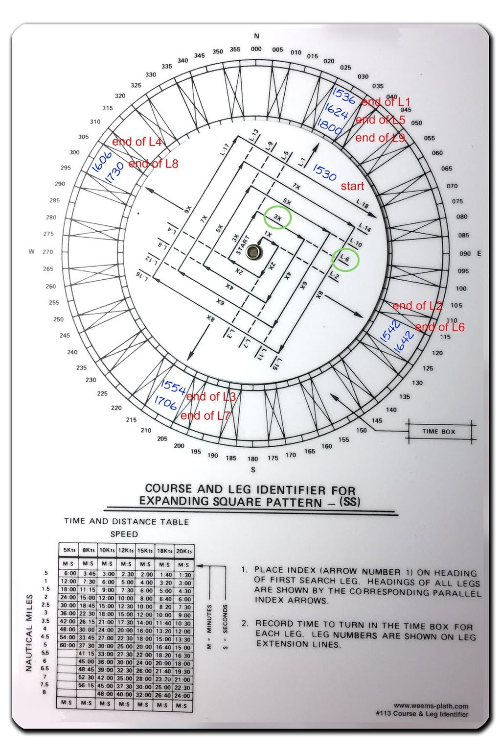
2
 of times for various leg separations and boat speeds.")
3 Procedure Step 1. Point the track to your initial heading in multiples of 15. Step 2. Choose your track spacing and boat speed, and enter the table (bottom left) of times for various leg separations and boat speeds. In the example used here, we choose legs 1 mile apart with a vessel speed of 10 kts. This gives us a time increment of 6 min. Had we chosen a separation of 1.5 miles with a boat speed of 12 kts, the tine interval would be 7m 30s. [This is just the boat speed in minutes per mile (60/S) multiplied by the distance run.] This 6 min the main time interval used to figure the times for each turn. Each leg has a multiplier on it. For leg 5 this is x3. See green circles in the figure. Step 3. Mark the start time at the base of leg 1, and then compute the turn times for each leg and write them with pencil in the spaces provided as shown. Pencil marks on this disk can be erased for later use. This step takes some care as mistakes are easy, so double check your work. Then you head off on the headings indicated and turn at the times you have marked. Obviously, if you do have a chart plotter, watch it to be sure you are making a square search pattern. Current or leeway could through this off but that is a feature, not a bug, as discussed at the end of this note. Below is this example, roughly laid out in OpenCPN (ie legs and headings not precisely set; just click, click, click...) and the corresponding route plan, which can be used to check if we were right with the Course and Leg Identifier.
 and the sector (VS) search patterns.")
4 After publishing this note, we received a valuable comment from an experienced user. This is reproduced below (with annotation), and it is now in the pdf copy of this article. Just wanted make a correction to the use of the expanding square (SS) and the sector (VS) search patterns. Both these patterns are intended to be drifting patterns as such they are never plotted on a chart or ECS. They are driven purely by stopwatch and compass. The distortion of the pattern by the on scene drift is actually desirable as your search object is also drifting. (The track of past positions will automatically be drawn on any echart program and these are valuable to monitor. The commenter's point is we are better off doing this by DR alone and not by course and speed over ground if there is any set or leeway.) Another idiosyncrasy of this tool worth mentioning is the proper track spacing for a man in the water is not on the table, namely 0.1 nm or 200 yards. Which is achieved by 1 minute legs at 6 knots, which is the clutch ahead speed for a lot of power driven vessels. When you arrive at the last known position of a vessel and she s not there, you have to assume you are looking for people in the water.

5 Take a minute to determine the set (and leeway by noting COG and SOG from the GPS when DIW.) Use that as your first leg course, then set off at clutch ahead and one minute legs. Usually the sector pattern is done first, start and end positions compared to get a more accurate set then a expanding square using that data. The length of each leg is largely determined by sea conditions and your range of clear visibility... and we do indeed want to have the current and leeway in mind. A person in the water will drift with the current, but will not be affected by leeway as much as the searching vessel will be. courtesy of
Expanding Square Search Pattern HEY! I M OVER HERE!!!
 Expanding Square Search Pattern HEY! I M OVER HERE!!! Expanding Square Search Characteristics: Criteria: v Used in relatively small search areas v v There is a good starting point Provides uniform coverage
Navigation with Leeway
 Navigation with Leeway Leeway, as we shall use the term, means how much a vessel is pushed downwind of its intended course when navigating in the presence of wind. To varying extents, knowledge of this
Search Techniques. Contents
 Search Techniques Contents Overview... 2 1. Developing the Search Plan... 2 1.1 Search Planning Sequence... 2 2. Search Terminology... 3 3. Search Patterns... 6 4. Searching and GPS... 8 5. Search Protocols...
Standard Underway Drills - All Platforms Search Patterns (Drifting Patterns) (Optional)
 (Optional)") Unit Name: Boat Nr: Score: SAT/UNSAT Coxswain: Engineer: Date: DD/MON/YR Crewmember: Crewmember: Indicate Search Pattern Used: VS, SS, Other Weather during drill: Winds: T KTS Seas: Swell: FT T FT T Current:
Unit Name: Boat Nr: Score: SAT/UNSAT Coxswain: Engineer: Date: DD/MON/YR Crewmember: Crewmember: Indicate Search Pattern Used: VS, SS, Other Weather during drill: Winds: T KTS Seas: Swell: FT T FT T Current:
Chartwork Learn the basics for position fixing using a number of techniques and a simple equation for speed, distance and time.
 Chartwork Learn the basics for position fixing using a number of techniques and a simple equation for speed, distance and time. Chartwork Chartwork Tools Accurate chart work is the basis for good navigation.
Basic Chartwork. Necessary Tools. Navigation is the one science in which no margin whatever is left for the faker. - Felix Riesenberg
 Page 1 of 14 www.bananawind.us Navigation is the one science in which no margin whatever is left for the faker. - Felix Riesenberg Basic Chartwork You wouldn't want to attempt open ocean sailing using
Mentoring in the USCG Auxiliary Boat Crew Program Coxswain Mentoring Template
 Notes: 1. When there is no reading assignment specified, the entire chapter contains references to the topic. 2. The study questions in the Qualification Guide should be completed for each task. Boat Crew
Standard Underway Drills - All Platforms
 Unit Name: Boat Nr: Score: SAT/UNSAT Coxswain: Engineer: Date: DD/MON/YR Crewmember: Crewmember: Indicate Search Pattern Used: PS, CS, TSN, TSR, Other Weather during drill: Winds: T KTS Seas: Swell: FT
Terrestrial Observations Chart Plot - Chesapeake Bay Entrance - Operational Level
 USCG 00326-NP-5 The following questions are based on chart 12221TR, Chesapeake Bay Entrance, and the supporting publications. The draft of your tow is 27 feet (8.2 meters). Use 10 W variation where required.
International Civil Aviation Organization
 International Civil Aviation Organization WORKING PAPER 11 August 2015 ENGLISH ONLY Agenda item 4 ICAO/IMO JOINT WORKING GROUP ON HARMONIZATION OF AERONAUTICAL AND MARITIME SEARCH AND RESCUE (ICAO/IMO
Lat. & Long. Review. Angular distance N or S of equator Equator = 0º Must indicate N or S North pole = 90º N
 Navigation Part 2 1 Lesson Objectives Understand how a ships compass works and how it is used for navigation Measure distances on nautical charts Plot a course on a nautical chart Correct course headings
Descent Planning with a Mechanical E6-B Flight Computer
 Descent Planning with a Mechanical E6-B Flight Computer Most pilots are familiar with an E6-B mechanical flight computer as it is considered to be an integral part of a new pilot s training for use with
START SAD & SAC KNOWLEDGE CHECK TEST
 Marine SAR Technical START SAD & SAC KNOWLEDGE CHECK TEST New Zealand Land Search and Rescue Inc. 2016 With thanks to Martin Paget, NZ Police. CREATIVE COMMONS These works may be downloaded or shared as
Mastering the Mechanical E6B in 20 minutes!
 Mastering the Mechanical E6B in 20 minutes Basic Parts I am going to use a Jeppesen E6B for this write-up. Don't worry if you don't have a Jeppesen model. Modern E6Bs are essentially copies of the original
Guide to Providing Shoreside and Underway Training Opportunities to Sea Cadets & Sea Scouts
 Guide to Providing Shoreside and Underway Training Opportunities to Sea Cadets & Sea Scouts The purpose of this document is to provide guidance for providing shoreside and underway training opportunities
Pilotage. Planning for pilotage
 Pilotage Planning for pilotage Being one step ahead of the game is key to effective pilotage. Only then will you know what to expect and what s lurking around the next bend. It s useful to construct a
28 Navigation Reminders Coastal Navigation by John C. Kelly, 2003
 28 Navigation Reminders Coastal Navigation by John C. Kelly, 2003 CRITICAL REMINDERS 1. Measure distance from latitude scales. 2. Take all bearings in degrees magnetic. 3. Always verify depth: surface
Welcome to Flotilla 4-76, Penn s Landing Public Education Program
 Welcome to Flotilla 4-76, Penn s Landing Public Education Program Instructions for filling out the Registration Form: Date: Please enter the date of the course in which you are interested. Course: Put
Title: 4-Way-Stop Wait-Time Prediction Group members (1): David Held
: David Held") Title: 4-Way-Stop Wait-Time Prediction Group members (1): David Held As part of my research in Sebastian Thrun's autonomous driving team, my goal is to predict the wait-time for a car at a 4-way intersection.
Title: 4-Way-Stop Wait-Time Prediction Group members (1): David Held As part of my research in Sebastian Thrun's autonomous driving team, my goal is to predict the wait-time for a car at a 4-way intersection.
STANDARDIZED AUXILIARY BOAT OPERATIONS TRAINING (SABOT) Job Aid FOR AUXILIARY BOATCREWS, TRAINERS, MENTORS AND QUALIFICATION EXAMINERS
 Job Aid FOR AUXILIARY BOATCREWS, TRAINERS, MENTORS AND QUALIFICATION EXAMINERS") STANDARDIZED AUXILIARY BOAT OPERATIONS TRAINING (SABOT) Job Aid FOR AUXILIARY BOATCREWS, TRAINERS, MENTORS AND QUALIFICATION EXAMINERS References: (a) Boat Crew Seamanship Manual, COMDTINST M16114.5 (series)
STANDARDIZED AUXILIARY BOAT OPERATIONS TRAINING (SABOT) Job Aid FOR AUXILIARY BOATCREWS, TRAINERS, MENTORS AND QUALIFICATION EXAMINERS References: (a) Boat Crew Seamanship Manual, COMDTINST M16114.5 (series)
LX Compass module 3 Electronic compass device User manual
 LX Compass module 3 Electronic compass device User manual LX navigation d.o.o., Tkalska 10 SLO 3000 Celje, tel: + 386 3 490 46 70, fax: + 386 3 490 46 71 info@lxnavigation.si, http://www.lxnavigation.com
1/6 CAL.YM88 1/5 SECOND CHRONOGRAPH WITH COUNTDOWN TIMER. Instructions. Features 24-hour, Hour, Minute and Small second hands.
 CAL. / OND CHRONOGRAPH WITH COUNTDOWN TIMER Features -hour, Hour, Minute and Small second hands Date Stopwatch Stopwatch hands: /-second and Minute hand. The stopwatch can measure up to minutes. Sprit
WORKBOOK NAVIGATION Tr. For Power-driven and Sailing Vessels DAVID BURCH LARRY BRANDT
 Piloting Dead reckoning Special publications Lights and buoys Electronic fixes Chart reading and plotting Compass use Navigation Rules Tides and currents Depth sounding navigation STARPATH This book provides
2005 ABC. Chapter 3 Part 2. Navigating with ATON's. Revision to D-13 Local Notes. Instructor Notes for Mike Brough. Mike Brough
 2005 ABC Chapter 3 Part 2 Navigating with ATON's Revision to D-13 Local Notes Instructor Notes for Mike Brough Mike Brough June 24 2008 June 24 2008 Slide 1 June 24 2008 New graphics Navigating on Water
Accident Report. Grounding Sanga Na Langa. 30 March 2006 Class C
 Accident Report Grounding Sanga Na Langa 30 March 2006 Class C REPORT NO.: 06 4041 VESSEL NAME: SANGA NA LANGA Ship Type: Certified Operating Limit: Flag: Commercial Passenger Enclosed & Inshore Limits
Note that this arming distance is not affected by the speed setting of your torpedoes.
 Torpedoes From SilentHunterIII Community Manual Range The minimum (arming) range for the torpedoes in SH3 is officially stated as 300m. However, some [subsim.com (http://www.subsim.com)] forum members
MANUAL. P C - C E N T E R Version Copyright by Dinand van het Reve CONTENTS
 P C - C E N T E R Version 4.00 Copyright 1995-2004 by Dinand van het Reve CONTENTS 1. Introduction 2. Installing PC-CENTER 3. Licence 4. Using PC-CENTER 5. Description of 'Small Windows' 6. Main Menu Description
THE FLIGHT COMPUTER AND NAVIGATION PLOTTER
 AND NAVIGATION PLOTTER GOAL: HOW TO USE A MANUAL E6B FOR FLIGHT PLANNING AND ENROUTE NAVIGATION. COMPUTING SIDE OF E6B Distance, Speed, and Time Enroute Fuel Consumption and Duration Computation of True
PART 5 - OPTIONS CONTENTS 5.1 SYSTEM EXPANSION 5-3
 PART 5 - OPTIONS CONTENTS Para Page 5.1 SYSTEM EXPANSION 5-3 5.2 SENSORS 5-3 5.2.1 Trim Angle Sensor 5-3 5.2.2 Mast Rotation Sensor 5-3 5.2.3 Heel Angle Sensor 5-3 5.2.4 Barometric Pressure Sensor 5-3
How to measure water flow?
 How to measure water flow? Measuring Flow The second major step in evaluating your site s hydro potential is measuring the flow of the stream. Stream levels change through the seasons, so it is important
Learning to Interpret My GPS Files
 Learning to Interpret My GPS Files I have arranged my GPS waypoint naming system to follow a certain format. I hope they are not too confusing for you to use. Listed below will be examples that you will
Sail Canada Uniform Navigation Symbols and Terms
 Uniform Navigation Symbols and Terms This publication provides definitions, shows symbols and gives examples of the symbols and labels to be used on paper marine charts when planning and executing voyages.
Technology. Using Bluetooth
 Bluetooth is a communication technology that makes it possible to send and receive data without using wires. Using the Bluetooth features, you can set up a wireless connection between your NXT and other
The activity is designed to take about an hour start to finish.
 Troop 606 Orienteering Course Overview This Orienteering Course is designed to help Scouts satisfy requirements 4a and 4b for the First Class Rank. These requirements are as follows (as of 2017): 4a. Using
January Skippers, Mates, and Crews:
 January 2016 Skippers, Mates, and Crews: On behalf of Bremerton Yacht Club and all our members, I am pleased to welcome you to the 82 nd running of our annual Heavy Weather Predicted Log Race and Social
THE FLIGHT COMPUTER AND NAVIGATION PLOTTER
 AND NAVIGATION PLOTTER GOAL: HOW TO USE A MANUAL E6B FOR FLIGHT PLANNING AND ENROUTE NAVIGATION. COMPUTING SIDE OF E6B Distance, Speed, and Time Enroute Fuel Consumption and Duration Computation of True
Crease Play. The Crease Defined. Teaching Crease Play. Individual Crease Play
 The crease is one of the most important positions on the lacrosse field; unfortunately it is also the most underrated. The crease is similar to the front lines during a war. It is a place where players
Drone SAR System PRESENTED BY GOTOLONDON
 Drone SAR System PRESENTED BY GOTOLONDON 1 CONTENTS Mortality in MOB Situation MOB Detector Auto-search planner on ECDIS SAR DRONES SEARCH PERSON (15MIN) SAR Operation(Within half an hour) 2 GLOSSARY Abbreviations
SAFETY AND RESCUE BOAT HANDLING EXAM B
 SAFETY AND RESCUE BOAT HANDLING EXAM B PO Box 1260 Portsmouth, RI 02871 Tel 401 683-0800 Fax 401 683-0840 powerboat@ussailing.org www.uspowerboating.com US POWERBOATING an affiliate of US SAILING SAFETY
Tactical Compass Overview
 Tactical Compass Overview Clay Babcock Mar 8 th, 2018 3/9/18 1 Overview WYC Philosophy Compass Background Types of Compasses The Art of Going Upwind Well Other Device Functions Tactical Compasses Reviewed
Chapter 6 - The Compass Upon completion of this chapter, you will be able to:
 Chapter 6 - The Compass Upon completion of this chapter, you will be able to: Explain the use of the 360 degree system in defining direction. Identify the parts of a compass, i.e.: - base plate - magnetic
RACE MANAGEMENT POLICY GUIDELINES FOR THE FINN CLASS MAJOR CHAMPIONSHIPS 2018.
 RACE MANAGEMENT POLICY GUIDELINES FOR THE FINN CLASS MAJOR CHAMPIONSHIPS 2018. Please note that these policies are guidelines to the Race Management Team. Failure to observe these guidelines are not grounds
Race Management Policies for SB20 World Championship 2018
 Race Management Policies for SB20 World Championship 2018 Based on Race Management Policies for World Sailing Events Fleet Racing 3 October 2017 Race Management Policies for SB20 World Championship 2018
OSSA MINIMUM SEARCH & RESCUE CERTIFICATION / QUALIFICATION CRITERIA BASIC LEVEL
 OSSA MINIMUM SEARCH & RESCUE CERTIFICATION / QUALIFICATION CRITERIA BASIC LEVEL Chapter 1 LEGAL ISSUES Through written evaluation the applicant will demonstrate knowledge of the legal issues involved in
Race Management Policies for World Sailing Events Fleet Racing Updated for Oceania & Australian Laser Regattas
 Race Management Policies for World Sailing Events Fleet Racing Updated for Oceania & Australian Laser Regattas 31 Dec 2018 Principles in the revision Make the statements more the order in which they occur
Nautical Navigation: Final Quiz
 Name: Nautical Navigation Final Quiz Class: (ver. 03/09/15) Date: Page 1 of 9 Nautical Navigation: Final Quiz There are three sections: Multiple Choice, True/False, and Short Answer. For the multiple choice,
Letter Latitude Longitude A B C D E F G
 Co-ordinates Problem Using your dividers and the chartlet on the following page complete this table. Letter Latitude Longitude A B C D E F G Nautical Charts Review. Questions 1. A Mercator projection
DIVER NAVIGATION BOARD. RJE International, Inc. RJE International Feb 1, TAC-100D Revision 10
 DIVER NAVIGATION BOARD RJE International, Inc. YOUR SOURCE FOR DIVER NAVIGATION AND UNDERWATER RELOCATION EQUIPMENT RJE International Feb 1, 2017 12 TAC-100D Revision 10 RJE International, Inc. 15375 Barranca
Section D 4: Introduction to plotting
 Boating Course Student s Notes Section 4 Section 4: Introduction to plotting 4.1 General If a boat is being conned through a winding channel where there is a great deal of boat traffic, the helmsman is
Collision in restricted visibility
 August 2018 Collision in restricted visibility Vessel A, a container vessel, was approaching the pilot station at full speed which was 17 knots and on a course of 280. It was in the afternoon there was
SP-110 Autopilot OPERATION
 SP-110 Autopilot OPERATION www.si-tex.com Warning! WHEN USING THE AUTOPILOT AN ADEQUATE WATCH SHOULD BE MAINTAINED AT ALL TIMES. THE AUTOPILOT MUST BE PLACED IN MANUAL MODE WHEN EVER THE VESSEL IS STATIONARY
Technology. Using Bluetooth
 Bluetooth is a communication technology that makes it possible to send and receive data without using wires. Using the Bluetooth features, you can set up a wireless connection between your NXT and other
Chapter IV - Sample Chart #1 Answers to Sample Chart #1
 Chapter IV - Sample Chart #1 Answers to Sample Chart #1 1. 29 10' N 2. 29 04' N 3. 28 57' N 4. 28 46' N 5. 28 38' N 6. 28 25' N 7. 28 17' N 8. 28 08' N 9. 27 51' N 10. 27 46' N Chapter IV - Sample Chart
Free Computer Design Tools For The Richard Joyner Offset Pendant Chucks By: Bill Kloepping, February 2018
 Free Computer Design Tools For The Richard Joyner Offset Pendant Chucks By: Bill Kloepping, February 2018 Free Excel spreadsheets allow you to quickly see how different chuck set-up combinations look when
Supplement to. Navigation Workbook for Practice Underway.
 Supplement to Navigation Workbook for Practice Underway. This file contains duplicate printable workrooms, plotting sheets, and logbook pages to use with the workbook as needed. They are the blank forms
AIR NAVIGATION. Key Revision. Press F5 to start.
 AIR NAVIGATION Key Revision Press F5 to start. This presentation may be used either as a revision aid or as a self-test program. Revision Self-test Instructions This presentation may be used either as
TAC-100A DIVER NAVIGATION BOARD OPERATIONS MANUAL. RJE International, Inc. RJE International, October 20, TAC-100A Revision 3
 TAC-100A DIVER NAVIGATION BOARD OPERATIONS MANUAL RJE International, Inc. YOUR SOURCE FOR DIVER NAVIGATION AND UNDERWATER RELOCATION EQUIPMENT RJE International, October 20, 2010 12 TAC-100A Revision 3
DeWiggler. Get your calibrations under control
 DeWiggler Get your calibrations under control DeWiggler Pro DeWiggler Pro comes aboard with a calibration professional. Calibrations are determined and set in real-time. When the calibrator leaves, Pro
DIVER NAVIGATION BOARD
 RJE International, May 14, 2015 12 TAC-100A Revision 4 DIVER NAVIGATION BOARD RJE International, Inc. YOUR SOURCE FOR DIVER NAVIGATION AND UNDERWATER RELOCATION EQUIPMENT RJE International, Inc. 15375
More on Running Tracks
 return to updates More on Running Tracks by Miles Mathis In a recent update to my paper on pi, I showed that Olympic running tracks were mismeasured in the turns. One of my loyal readers, who thinks I
National Maritime Center
 National Maritime Center Providing Credentials to Mariners (Sample Examination) Page 1 of 5 Choose the best answer to the following Multiple Choice Questions. 1. The following questions are based on Chart
Contents. Chapter 1 Important information Chapter 4 Pilot views Chapter 5 Pilot modes Chapter 2 Handbook information...
 Contents Chapter 1 Important information... 7 Safety notices... 7 TFT LCD Displays... 8 Water ingress... 8 Disclaimers... 8 EMC conformance... 8 Suppression ferrites... 9 Connections to other equipment...
Navigation Using Compass
 Navigation Using Compass Updated January 2015 Albi Sole 0 Outdoor Council of Canada / Conseil canadien de plein air Published by The Outdoor Council of Canada / Conseil canadien de plein air KNA-101, 2500
Besides the reported poor performance of the candidates there were a number of mistakes observed on the assessment tool itself outlined as follows:
 MATHEMATICS (309/1) REPORT The 2013 Mathematics (309/1) paper was of average standard. The paper covered a wide range of the syllabus. It was neither gender bias nor culture bias. It did not have language
IODA RACE MANAGEMENT GUIDELINES
 IODA RACE MANAGEMENT GUIDELINES These guidelines are published for race officers, sailors and coaches as guidelines on how racing will be conducted, they are not rules. Failure to follow these guidelines
57 TH MBYC BOOMERANG NAVIGATION CONTEST MARCH 2,3,& COURSE DESCRIPTION AND RULES
 57 TH MBYC BOOMERANG NAVIGATION CONTEST MARCH 2,3,&4 2018 COURSE DESCRIPTION AND RULES Please see instructions to sign up for the event, dinner, etc. in a separate communication. Questions? Contact Paul
Race Management Recommended Policies for Nordic Folkboat Gold Cup
 Race Management Recommended Policies for Nordic Folkboat Gold Cup Principles behind the recommendation This document is excerpts from the sailing.org Race Management WM Policies adjusted to the Statutes
English. English. Predictive Multi Gas for
 English English Predictive Multi Gas for TABLE OF CONTENTS 1. Glossary...1 English 2. Pairing of transmitters and gas summary table...2 3. PMG menu...2 4. RBT=0min in Gas integration menu...2 5. Screen
DIVER NAVIGATION BOARD
 RJE International, October 20, 2010 12 TAC-200A Revision 3 DIVER NAVIGATION BOARD RJE International, Inc. YOUR SOURCE FOR DIVER NAVIGATION AND UNDERWATER RELOCATION EQUIPMENT RJE International, Inc. 15375
LifeBeat should be worn during daytime as well as night time as it can record activity levels as well as sleep patterns.
 myhealth FAQ V1.0.5 GENERAL What is LifeBeat Stress Tracker? LifeBeat Stress Tracker is a system that lets you track your activity, sleep, and especially your various stress levels, so that you can improve
CRICKET SCORING GUIDE
 CRICKET SCORING GUIDE South Morang Cricket Club Scoring Guidance 2015 1 CRICKET SCORING THE FIRST STEPS This manual has been written to help introduce new scorers to basic methods of scoring and to answer
Electronic Recording Using FieldLynx Grade 2 ERD Skills
 Electronic Recording Using FieldLynx Grade 2 ERD Skills An introductory manual for using the FieldLynx System in electronic recording for USATF Officials. Prepared by Laura Gast November 2014 Table of
OPERATION AND INSTALLATION MANUAL
 AP46 Autopilot OPERATION AND INSTALLATION MANUAL www.tmq.com.au TMQ AP46 Autopilot Page 1 of 34 Ver1.0 07/03/2007 This page is Blank TMQ AP46 Autopilot Page 2 of 34 Ver1.0 07/03/2007 WARNING!...4 INTRODUCTION...5
GULF OF GEORGIA NORTH PUGET SOUND SOUTH PUGET SOUND
 June 8, 2018 GULF OF GEORGIA NORTH PUGET SOUND SOUTH PUGET SOUND Skippers, Mates & Crews, On behalf of the IPBA and all of its members, let me welcome you to our 2018 ICR, course and compass contest/rally.
PADI OPEN WATER DIVER MANUAL PDF PDF
 PADI OPEN WATER DIVER MANUAL PDF PDF ==> Download: PADI OPEN WATER DIVER MANUAL PDF PDF PADI OPEN WATER DIVER MANUAL PDF PDF - Are you searching for Padi Open Water Diver Manual Pdf Books? Now, you will
National Maritime Center
 National Maritime Center Providing Credentials to Mariners Q163 Navigation Problems-Chart 13205 TR (Sample Examination) Page 1 of 5 Choose the best answer to the following Multiple Choice Questions. Each
August April 18,2008 First Revision
 August 15 2011 Slide 01 April 18,2008 First Revision August 15, 2011 Text converted to Tables for ease of formatting instructor guide. Slide 23 Sound Signals Corrected Danger Signal 5 or More Short Blasts
ST70 Autopilot Controller User Reference Guide
 ST70 Autopilot Controller User Reference Guide Document reference: 81288-2 Date: May 2010 ii iii Contents Preface Warnings and cautions WARNING: Product installation & operation This equipment must be
1/6 CAL. YM62 1/5 SECOND, ALARM CHRONOGRAPH. Instructions. Features. Movement Size mm (12H-6H) x mm (3H-9H) 3.70 mm (Include battery)
 x mm (3H-9H) 3.70 mm (Include battery)") CL. 1/ SECOND, CHRONOGRPH 1/ Features Hour, Minute and Small second hands Date larm : Single time alarm Can be set to ring only once at a designated time within the coming hours. Stopwatch 2 Stopwatch
CL. 1/ SECOND, CHRONOGRPH 1/ Features Hour, Minute and Small second hands Date larm : Single time alarm Can be set to ring only once at a designated time within the coming hours. Stopwatch 2 Stopwatch
Land Survey. 1. Pick the two points (A and B) that you would like to measure. You must be able to see clearly between the two points.
 that you would like to measure. You must be able to see clearly between the two points.") Land Survey William Clark did most of the surveying and mapping for the Lewis and Clark Expedition. When he needed to measure the distance between two points that were far apart, he used a method called
Land Survey William Clark did most of the surveying and mapping for the Lewis and Clark Expedition. When he needed to measure the distance between two points that were far apart, he used a method called
Navigation & Orienteering: Pre- Test
 Name: Class: Answer Key Date: Page 1 of 7 Navigation & Orienteering: Pre- Test There are three sections: Multiple Choice, True/False, and Short Answer. For the multiple choice, please select the BEST answer
Section 1: Multiple Choice Explained EXAMPLE
 CFSP Process Applications Section 1: Multiple Choice Explained EXAMPLE Candidate Exam Number (No Name): Please write down your name in the above provided space. Only one answer is correct. Please circle
Jack Hyde Memorial Navigation Contest Saturday, March 18, 2017 The Same Only Different
 Jack Hyde Memorial Navigation Contest Saturday, March 18, 2017 The Same Only Different March 17, 2018 Skippers, Mates and Crews, On behalf of the Tacoma Yacht Club let me welcome you to the running of
Network Safeworking Rules and Procedures
 Network Safeworking Rules and Procedures Indicators Rule Number: 6009 Version 1.0, 31 March 2016 Indicators Rule Number: 6009 Document Control Identification Document title Number Version Date 6009 Indicators
Naval Postgraduate School, Operational Oceanography and Meteorology. Since inputs from UDAS are continuously used in projects at the Naval
 How Accurate are UDAS True Winds? Charles L Williams, LT USN September 5, 2006 Naval Postgraduate School, Operational Oceanography and Meteorology Abstract Since inputs from UDAS are continuously used
Introduction. The Shearwater Petrel is an advanced technical diving computer for open and closed circuit divers.
 Introduction The Shearwater Petrel is an advanced technical diving computer for open and closed circuit divers. Although we strive to make the Petrel easy enough to use without reading the manual, please
13. TIDES Tidal waters
 Water levels vary in tidal and non-tidal waters: sailors should be aware that the depths shown on the charts do not always represent the actual amount of water under the boat. 13.1 Tidal waters In tidal
GHC Remote Control Instructions manual
 GHC Remote Control Instructions manual Instructions What s In The Box Before installing your remote, confirm that your package includes these items. GHC Remote Control Two GHC Remote Control cradles Four
Calculation of Trail Usage from Counter Data
 1. Introduction 1 Calculation of Trail Usage from Counter Data 1/17/17 Stephen Martin, Ph.D. Automatic counters are used on trails to measure how many people are using the trail. A fundamental question
USING THE MILITARY LENSATIC COMPASS
 USING THE MILITARY LENSATIC COMPASS WARNING This presentation is intended as a quick summary, and not a comprehensive resource. If you want to learn Land Navigation in detail, either buy a book; or get
CALCULATING IN-FLIGHT WINDS
 CALCULATING IN-FLIGHT WINDS SITUATION: The TH of your aircraft is 350 with the TAS of 150 kts. GS has been determined to be 160 kts, and the Track is 355. What is the wind? ESTIMATE! First compare TAS
Rule 35 - Sound signals in restricted visibility
 Rule 35 - Sound signals in restricted visibility In or near an area of restricted visibility, whether by day or night, the signals prescribed in this Rule shall be used as follows: (a) A power-driven vessel
COMBAT SWIM BOARD. RJE International, Inc. RJE International Feb 1, TAC-300 Revision 6
 COMBAT SWIM BOARD RJE International, Inc. YOUR SOURCE FOR DIVER NAVIGATION AND UNDERWATER RELOCATION EQUIPMENT RJE International Feb 1, 2017 12 TAC-300 Revision 6 RJE International, Inc. 15375 Barranca
AUTOPILOT. NAVpilot-500
 AUTOPILOT NAVpilot-500 Your Local Agent/Dealer 9-52 Ashihara-cho, Nishinomiya, Japan Telephone : 0798-65-2111 fax : 0798-65-4200 ( HIMA All rights reserved. PUB.No. OME-72500 ) NAVPILOT-500 Printed in
frequently asked questions
 Hydra Pilot Fault Codes What do the fault codes for the Hydra Pilot mean? Fault Cause FAULT 100 FAULT 101 FAULT 102 FAULT 103 FAULT 104 FAULT 105 FAULT 106 FAULT 108 FAULT 109 FAULT 110 FAULT 111 FAULT
GCSE Mathematics. Foundation Tier
 For Edexcel Name GCSE Mathematics Paper 2F (Calculator) Foundation Tier Time: 1 hour and 30 minutes Materials required Ruler, protractor, compasses, pen, pencil, eraser. Tracing paper may be used. Instructions
Race Area Analyzer Solent
 Race Area Analyzer Solent Mac or Windows Getting Started buell software gmbh Esmarchstraße 53 24105 Kiel 2018 Content 1 Screen Layout... 1 2 Zoom Functions... 2 3 Enter Boat Class... 2 4 Enter day and
COMBAT SWIM BOARD. RJE International, Inc. RJE International January 16, TAC-300 Revision 4
 COMBAT SWIM BOARD RJE International, Inc. YOUR SOURCE FOR DIVER NAVIGATION AND UNDERWATER RELOCATION EQUIPMENT RJE International January 16, 2017 RJE International, Inc. 15375 Barranca Pkwy, Ste. I-112,
 Automatic level / Optical level / Dumpy Level Instruction Manual www.level1lasers.com.au Contents Introduction 2 Diagram 3 Operation Instruction 4 Calibration Self-Check 5 Technical Specifications 6 Maintenance
Navigation Exercises for Practice Underway
 Workforms and Plotting Sheets for use with Navigation Exercises for Practice Underway www.starpath.com/kindle David Burch STARPATH Seattle, WA Copyright 2009, 2012 David Burch All rights reserved. No part