A Wind Profiling Platform for Offshore Wind Measurements and Assessment. Presenter: Mark Blaseckie AXYS Technologies Inc.
|
|
|
- Amie Stevens
- 5 years ago
- Views:
Transcription

1 A Wind Profiling Platform for Offshore Wind Measurements and Assessment Presenter: Mark Blaseckie AXYS Technologies Inc.

2 Any Sensor, Any Telemetry, Any Environment
3 Founded in 1974 Part of the AXYS Group AXYS History Marine consulting contracts with EC for wave studies Design of marine technology devices s Data buoys for EC Weather Buoy Network s collaboration with NRC TRIAXYS and WM500 Over 300 buoys in more than 30 countries Leveraged into hydrological and aviation products in 2002; offshore wind assessment in 2008 ISO 9001:2008 Certified
4 Focus Environmental monitoring solutions provider focused on specific market niches: Marine Met Ocean Physical Oceanography Water Quality Hydrology Greenhouse Gas Water Quality Hydrometeorology Wind Resource Assessment Offshore met/wind profiling structures Offshore met/wind profiling buoys Onshore met/wind profiling Aviation Services Field Service Consulting Leasing


5 Waves, Currents, Water-level Monitoring TRIAXYS Directional Wave Buoy TRIAXYS with Currents Buoy TRIAXYS Mini Directional Wave Buoy HydroLevel Buoy Motion Sensor Data Advanced motion & directional wave analysis Near real-time directional wave and current data Water elevation for hydrographic surveys


6 Met Ocean Weather & Observing Platforms 3 Metre Buoy NOMAD Buoy WatchKeeper Buoy WatchMate Buoy Data Weather Air & Water Quality Directional waves & currents


7 Fixed Stations Meteorological and oceanographic data collection and transmission system for vessel traffic management Data Real-time wind speed, wind direction, current speed, current direction, and water level information Port Sentinel RigSentinel Application Cruise Ship Safety - Victoria Port Authority

8 Field Service: Deployment/Installation Repair/maintenance Training Mooring Design Consulting Leasing Services


9 Hydrology Hydrometeorology remote hydrological monitoring networks flood forecasting river & stream habitat monitoring reservoir management Water Quality continuous fresh water monitoring environmental assessments for natural resource industries, source drinking water protection Greenhouse Gas automated GHG concentration monitoring system

10 Why Offshore Wind? Growth in the wind energy industry has come from the urgent need to combat climate change. While wind can be harnessed both on land and offshore, more frequently, developers are looking offshore where the wind blows stronger and more consistently. Offshore winds tend to flow at higher speeds than onshore winds, thus allowing turbines to produce more electricity. Since the potential energy produced from the wind is proportional to the cube of the wind speed, increased wind speeds of only a few miles per hour can produce a significantly larger amount of electricity. Therefore, offshore wind turbines have a higher capacity factor and generate energy more efficiently. Much of this potential energy is near major population centers where energy costs are high and land-based wind development opportunities are limited.
11 Wind Assessment Industry Overview Wind resource assessment is the process by which wind power developers estimate the future energy production of a wind farm. Accurate wind resource assessments are crucial to the successful development of wind farms. Regional wind maps are valuable tools for site finding, but are not accurate enough to justify the financing of the development. The single most important characteristic of a site is its wind speed and the performance of a wind farm is very sensitive to uncertainties and errors in the basic wind speed estimate. This means that initial wind resource assessment must be extremely accurate in order to procure funding, as well as for the economic development of a wind farm. Currently wind resource assessments are completed by remote meteorological observation masts secured to the sea bed in waters that can be as deep as 80 meters. These masts take as long as a year to gain construction permissions and to complete environmental assessments and a further year to build. AXYS Instrumented Naikun Wind Platform
12 WindSentinel Solution Meteorological masts are very costly to build ($5m to $10m) and non-mobile as well as non reusable. Meteorological masts typically measure wind at heights below the blade span and hub height of typical offshore wind turbines. Construction delays resulting from permitting and environmental assessment periods create wind resource assessment delays of up to two years. AXYS Technologies was tasked with developing an alternative solution: WindSentinel is a very cost effective, mobile and reusable wind assessment tool. It should allow the developer to gather more, better and more relevant data as either a stand alone met mast replacement or in conjunction with a met mast wind resource campaign (where it reduces the uncertainties applied to WRA data) Minimal deployment delays can significantly reduce wind assessment periods WindSentinel is mobile for quick deployment at multiple wind assessment locations

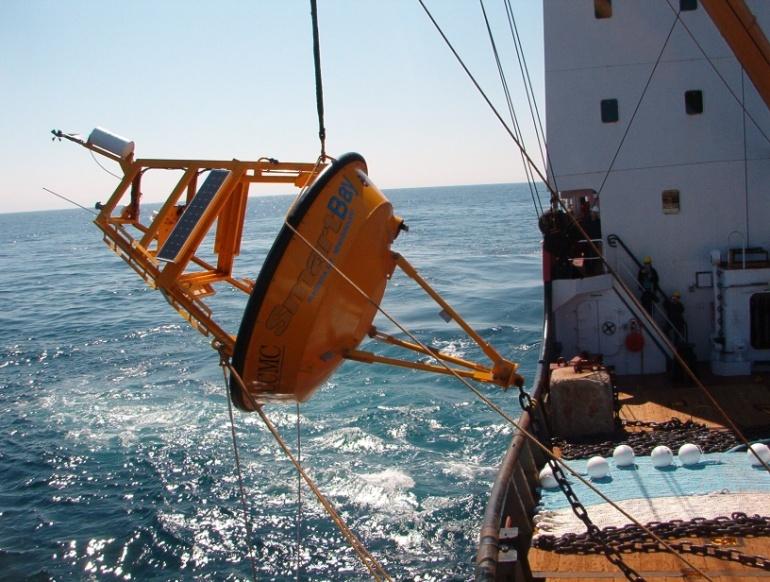
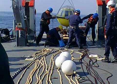
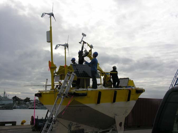
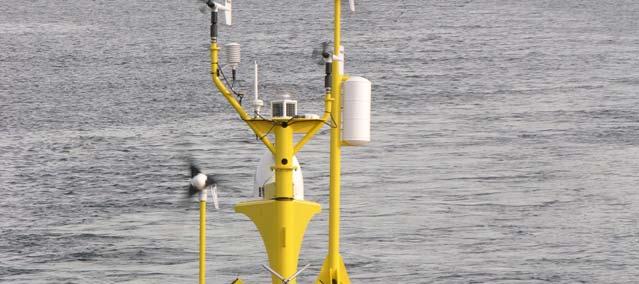
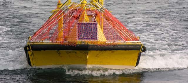
13 The WindSentinel Designed to be the world s first wind resource assessment buoy capable of accurately gathering wind data at turbine hub-height and across the blade span. Uses a Laser Wind Sensor Replacement for met towers Prospecting and siting Can reduce applied assessment uncertainty
: 0.")

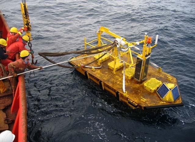
14 The WindSentinel Hull Wind Sentinel Physical Specs Length: 6.10m Beam: 2.92 m Water Line (from Deck): 0.61m Weight (Fully Assembled): 8700 kg Forward Mast Sensor Specs Laser Wind Sensor Lens to Deck: Laser Wind Sensor Profiling Height Port Anemometer to Deck: Starboard Anemometer to Deck: 2.50 m up to 300m 3.00 m 3.50 m


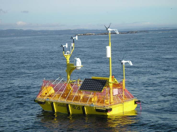
15 Power System 2 x 210W Solar Panels 2 x 400W Turbines Many Lead Acid Batteries The WindSentinel

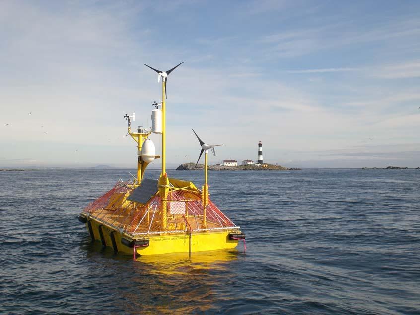
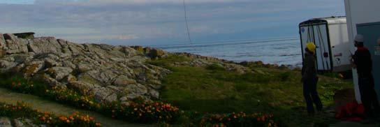
16 The WindSentinel WatchMan500 Remote configuration and diagnostics capabilities Diverse data collection, and communication capabilities. Expandable, Low Power

17 The WindSentinel Data Management System (DMS) Provides complete control of the WatchMan500 systems. Real-time and scheduled control of system operation and configuration. Data storage to MS SQL Database. Data can be pushed or polled from a station to the DMS.

18 The WindSentinel Communications A small list of the many supported options Cellular Modems Inmarsat D+, Inmarsat C Iridium GlobalStar AIS ARGOS, GOES VHF Radio
19 The WindSentinel Laser Wind Sensor (Pulsed Doppler Velocimeter) Solid state sensor Measures real-time horizontal and vertical wind speed and direction corrected for instantaneous motion Wind measurements taken at various bins up to 300m.
20 The WindSentinel Met Sensors Barometer Dual RM Young Wind Sensors Air Temperature and Relative Humidity Additional Sensors TRIAXYS Wave Sensor 3-axis compass Sea Surface Temperature Current Profiler Depth Sensor Power monitoring on all major power sinks and sources

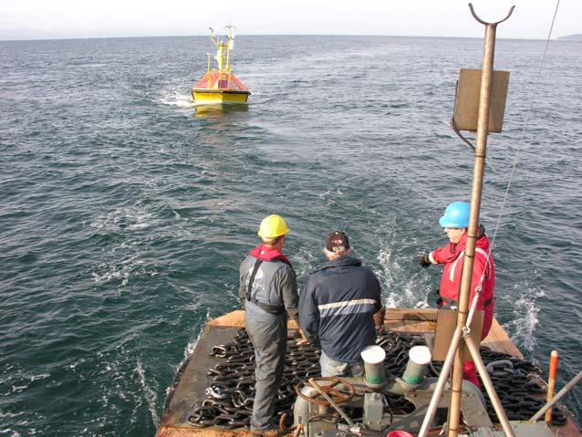
21 The Trial Comparison of wind data between a stationary and moving platform Proof of platform suitability for this application Performance evaluation
22 Trial Information Trial Date October 20, 2009 to November 20, 2009 Parameters measured Wave Motion Water Depth Basic MET (ie. Air Temp, Humidity, Surface Winds, Barometric Pressure) Wind Speeds and Directions at 100m, 150m and 200m bin heights

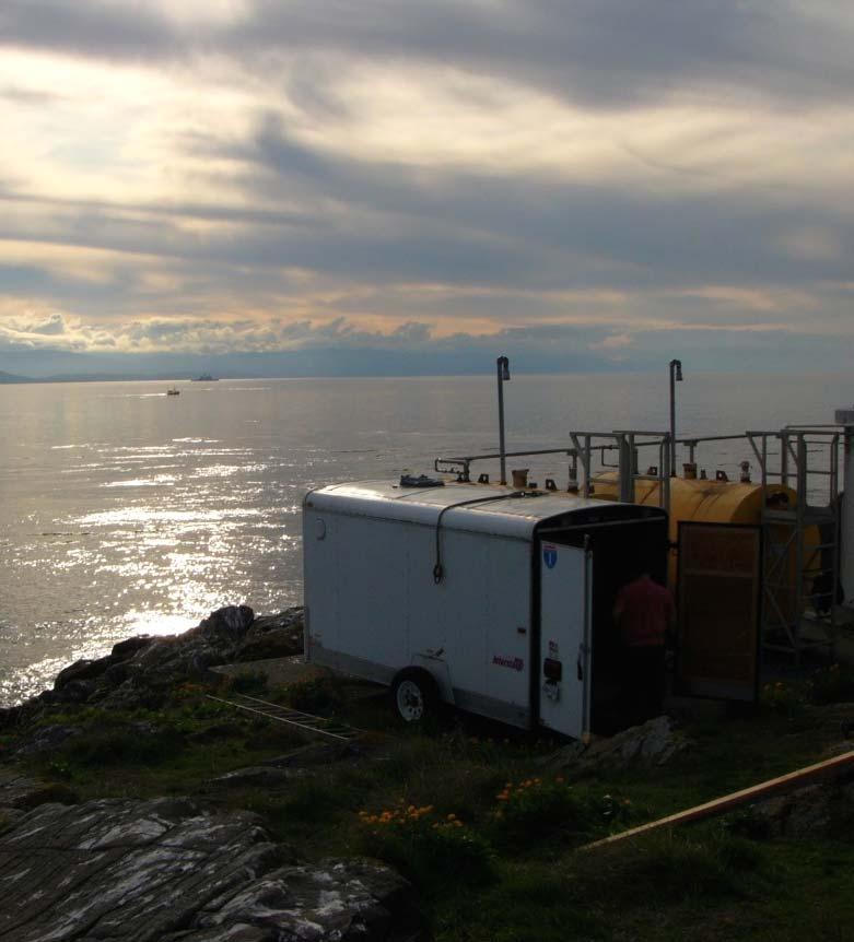
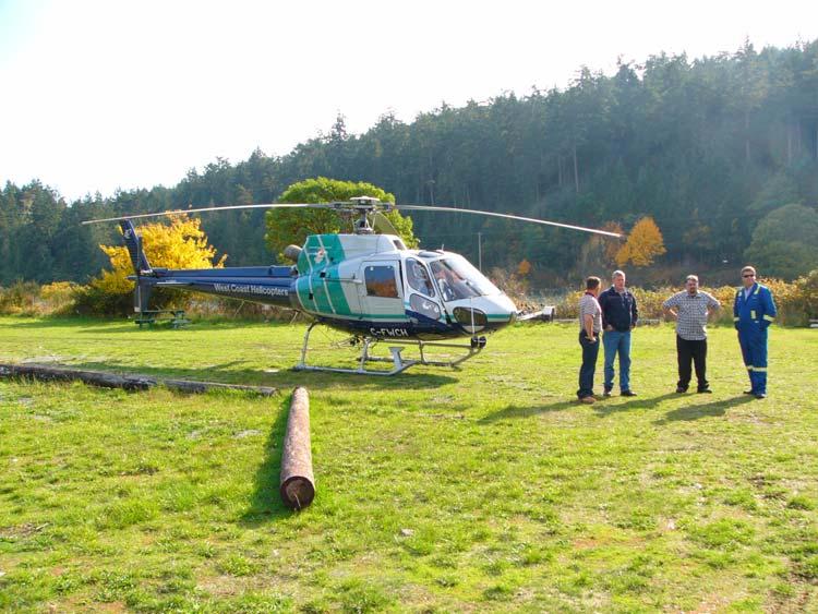
23 Land Station

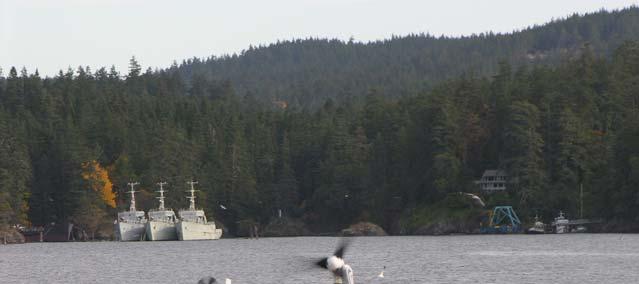
24 Location Race Rocks Test Site
25 Anticipated Issues The effects that obstructions or land mass may have on wind. Separation between the two sites (approximately 700m). Laser wind sensor performance. Impact of buoy motion Profiling height difference


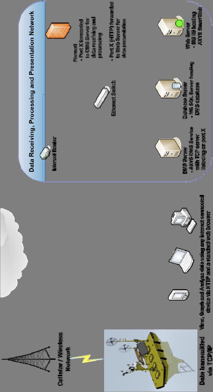
26 System configuration and data links
27 DMS and Data Storage Over the Trial Number of messages logged by the W500: > 7.8 million (1.8GB) Messages transmitted in real time: > Data managed by the DMS: ~10GB
28 Summary Wind Data Wind Sentinel Wind Data Summary Statistics Description Mean Min Max VIN 100m Wind Speed [m/s] VIN 150m Wind Speed [m/s] VIN 200m Wind Speed [m/s] AN1 Wind Speed [m/s] AN2 Wind Speed [m/s] Land Station Wind Data Summary Statistics Description Mean Min Max VIN 100m Wind Speed [m/s] VIN 150m Wind Speed [m/s] VIN 200m Wind Speed [m/s] AN1 Wind Speed [m/s]

29 Summary Wind Data -Data temperature/baro waves surface wind
30 Summary Conditions
31 Summary Wave Data Wind Sentinel TRIAXYS Wave Sensor Summary Statistics Description Mean Min Max Hmax Hsig TP
32 Summary Conditions -Data temperature/baro waves surface wind
33 Summary Conditions Wind Sentinel Meteorological Summary Statistics Mean Min Max Description Temp [ C] Humidity [%] Dewpoint [ C] Pressure[mb] Land Station Meteorological Summary Statistics Mean Min Max Description Temp [ C] Humidity [%] Dewpoint [ C] Pressure[mb]
34 Comparison Statistics Description 0-4m/s 4-8m/s 8-12m/s 12-16m/s 16-20m/s Mean Max Std Mean Max Std Mean Max Std Mean Max Std Mean Max Std Wind Speed 200m Wind Speed AN Wind Direction 200mφ
35 Anemometer Wind Sensor Difference Laser Wind Sensor Percent Difference
36 Correlation Sensor to Sensor
37
38 Correlation Wind difference to wave height
39
40 The WindSentinel - Outcome Shows good feasibility for a Laser Wind Sensor mounted on a buoy for use in a wind resource assessment We have shown that, if done correctly, wind measured from a Laser Wind Sensor on a moving platform is not significantly different then wind measured from a stationary Laser Wind Sensor
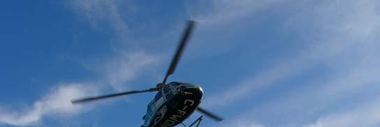
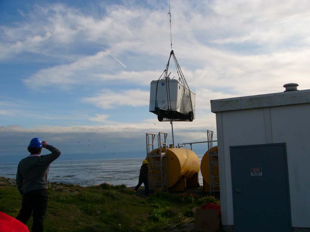
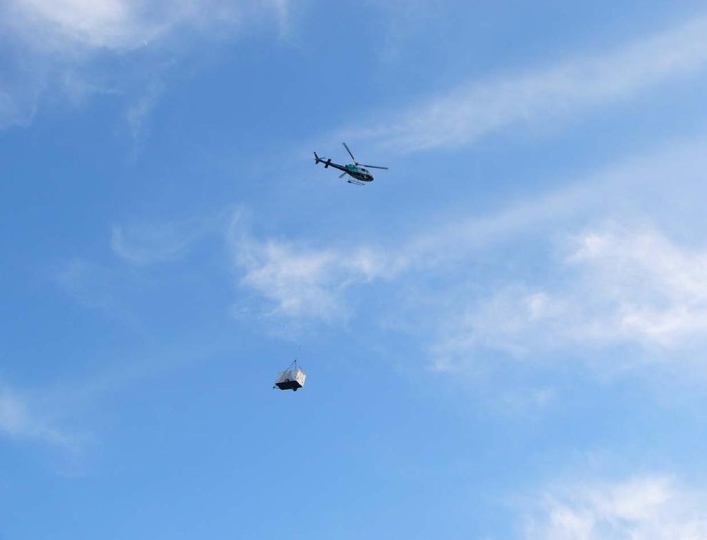
41 Issues Encountered and Solutions. System Issues Compass heading Wind turbine failure (12 m/s shutdown) Power requirements Deployment Issues Working within a Marine Protected Area Complex to deploy from a 35ft tug Land Station deployment location accessible only by air
42

43
44
45


46
47
48
49
50 Thank you. Questions will be taken at the end of the session.
TRIAXYS Acoustic Doppler Current Profiler Comparison Study
 TRIAXYS Acoustic Doppler Current Profiler Comparison Study By Randolph Kashino, Axys Technologies Inc. Tony Ethier, Axys Technologies Inc. Reo Phillips, Axys Technologies Inc. February 2 Figure 1. Nortek
Offshore Wind Energy Stringent quality assurance and quality control. Coastal and Freshwater Fast responding and flexible organisation
 Services Oceanographic and Positioning Equipment Rental Meteorological and Oceanographic Surveys Data Analysis and Characterisation Marine Energy Resource Assessment Real-Time Monitoring Founded in 2010,
National Report of China
 National Report of China Yu Ting (NMDIS), State Oceanic Administration (SOA), China DBCP 29, 27 Sep. 2013, Paris, France Contents 1 Current program status 2 Future deployment plan 3 Technical development
EMPOWERING OFFSHORE WINDFARMS BY RELIABLE MEASUREMENTS
 EMPOWERING OFFSHORE WINDFARMS BY RELIABLE MEASUREMENTS Joerg Bendfeld University of Paderborn Fakultät Elektrotechnik, Mathematik und Informatik Lehrstuhl für Elektrische Energietechnik Pohlweg 55 D-33014
SVP-B drifter built by METOCEAN Use and deployment instructions
 Centre de Meteorologie Marine Tel: +33 2 98 22 18 52 Meteo-France Fax: +33 2 98 22 18 49 13, rue du Chatellier E-mail: Pierre.Blouch@meteo.fr BP 90411 29604 BREST CEDEX France SVP-B drifter built by METOCEAN
Wind Project Siting and Permitting Blaine Loos
 Wind Project Siting and Permitting Blaine Loos Energy Project Analyst Center for Wind Energy at James Madison University Wind Project Siting and Permitting The Energy in Wind Resource Assessment (Macro-siting)
MOTUS Wave Buoys. Powered By the Aanderaa MOTUS Directional Wave Sensor
 MOTUS Wave Buoys Powered By the Aanderaa MOTUS Directional Wave Sensor Two Buoys, One Brain The Aanderaa MOTUS directional wave sensor factory calibrated and currently available on two proven buoy platforms:
7 YEARS METEOMAST AMRUMBANK WEST
 7 YEARS METEOMAST AMRUMBANK WEST Joerg Bendfeld(1), Jens Krieger(2) (1) University of Paderborn, Kompetenzzentrum für nachhaltige Energietechnik KET, Pohlweg 55, 33098 Paderborn, Germany, (2) airwerk GmbH,
South Bay Coastal Ocean Observing System California Clean Beaches Initiative
 South Bay Coastal Ocean Observing System California Clean Beaches Initiative Quarterly Report September 2003 to City of Imperial Beach Eric Terrill 1 1 Scripps Institution of Oceanography, University of
Executive Summary of Accuracy for WINDCUBE 200S
 Executive Summary of Accuracy for WINDCUBE 200S The potential of offshore wind energy has gained significant interest due to consistent and strong winds, resulting in very high capacity factors compared
REMOTE SENSING APPLICATION in WIND ENERGY
 REMOTE SENSING APPLICATION in WIND ENERGY Siraj Ahmed Professor & Head Department of Mechanical Engineering Maulana Azad National Iinstitute of Technology Bhopal, India sirajahmed@manit.ac.in Contents
3D Nacelle Mounted Lidar in Complex Terrain
 ENERGY 3D Nacelle Mounted Lidar in Complex Terrain PCWG Hamburg, Germany Paul Lawson 25.03.2015 1 DNV GL 125.03.2015 SAFER, SMARTER, GREENER Agenda Introduction and Project Background Lidar Specifications
Validation of Measurements from a ZephIR Lidar
 Validation of Measurements from a ZephIR Lidar Peter Argyle, Simon Watson CREST, Loughborough University, Loughborough, United Kingdom p.argyle@lboro.ac.uk INTRODUCTION Wind farm construction projects
Wind Project Siting & Resource Assessment
 Wind Project Siting & Resource Assessment David DeLuca, Project Manager AWS Truewind, LLC 463 New Karner Road Albany, NY 12205 ddeluca@awstruewind.com www.awstruewind.com AWS Truewind - Overview Industry
Results and conclusions of a floating Lidar offshore test
 Results and conclusions of a floating Lidar offshore test J. Gottschall, G. Wolken-Möhlmann, Th. Viergutz, B. Lange [Fraunhofer IWES Wind Lidar Buoy next to FINO1 met. mast] EERA DeepWind'2014 Conference,
The Wave Glider: A Mobile Buoy Concept for Ocean Science. 009 Liquid Robotics Inc.
 The Wave Glider: A Mobile Buoy Concept for Ocean Science 009 Liquid Robotics Inc. J. Manley & T. Richardson: Liquid Robotics Inc. DBCP XXV Paris September 28, 2009 1 Wave Glider Overview Unique Two Part
Wind measurements that reduce electricity prices
 Wind measurements that reduce electricity prices Extensive testing in three countries has proven that laser measurements of wind provide precise, reliable wind data. The research findings will make it
Available online at ScienceDirect. Energy Procedia 53 (2014 )
") Available online at www.sciencedirect.com ScienceDirect Energy Procedia 53 (2014 ) 156 161 EERA DeepWind 2014, 11th Deep Sea Offshore Wind R&D Conference Results and conclusions of a floating-lidar offshore
Available online at www.sciencedirect.com ScienceDirect Energy Procedia 53 (2014 ) 156 161 EERA DeepWind 2014, 11th Deep Sea Offshore Wind R&D Conference Results and conclusions of a floating-lidar offshore
The Wind Resource: Prospecting for Good Sites
 The Wind Resource: Prospecting for Good Sites Bruce Bailey, President AWS Truewind, LLC 255 Fuller Road Albany, NY 12203 bbailey@awstruewind.com Talk Topics Causes of Wind Resource Impacts on Project Viability
Meteorological Measurements OWEZ
 Meteorological Measurements OWEZ Half year report - 01-07-2008-31-12-2008 H. Korterink P.J. Eecen J.W. Wagenaar ECN-E--09-018 OWEZ_R_121_20080701-20081231_WIND_RESOURCE_2008_2 Abstract NoordzeeWind carries
Meteorological Measurements OWEZ
 Meteorological Measurements OWEZ Half year report 01-01-2008-30-06-2008 H. Korterink P.J. Eecen ECN-E--08-062 OWEZ_R_121_20080101-20080630_wind_resource_2008_1 Abstract NoordzeeWind carries out an extensive
The Evolution of an Autonomous Unmanned Surface Vessel and Software for Hydrographic Survey
 The Evolution of an Autonomous Unmanned Surface Vessel and Software for Hydrographic Survey Paul Donaldson In 2017, Leidos, Inc. participated in both the Gulf of Mexico Unmanned Systems Operational Demonstration
Crew Transfer Vessel (CTV) Performance Benchmarking. Presented by Stephen Phillips of Seaspeed Marine Consulting Ltd
 Performance Benchmarking. Presented by Stephen Phillips of Seaspeed Marine Consulting Ltd") Crew Transfer Vessel (CTV) Performance Benchmarking Presented by Stephen Phillips of Seaspeed Marine Consulting Ltd BACKGROUND - CT OWA : The Carbon Trust Offshore Wind Accelerator (OWA) brings together
Crew Transfer Vessel (CTV) Performance Benchmarking Presented by Stephen Phillips of Seaspeed Marine Consulting Ltd BACKGROUND - CT OWA : The Carbon Trust Offshore Wind Accelerator (OWA) brings together
RAMSTM. 360 Riser and Anchor-Chain Integrity Monitoring for FPSOs
 RAMS 360 Riser and Anchor-Chain Integrity Monitoring for FPSOs Introduction to RAMS Tritech s RAMS is a 360 anchor-chain and riser integrity monitoring system for Floating Production Storage and Offloading
7 th International Conference on Wind Turbine Noise Rotterdam 2 nd to 5 th May 2017
 7 th International Conference on Wind Turbine Noise Rotterdam 2 nd to 5 th May 2017 Sound power level measurements 3.0 ir. L.M. Eilders, Peutz bv: l.eilders@peutz.nl ing. E.H.A. de Beer, Peutz bv: e.debeer@peutz.nl
Increased Project Bankability : Thailand's First Ground-Based LiDAR Wind Measurement Campaign
 Increased Project Bankability : Thailand's First Ground-Based LiDAR Wind Measurement Campaign Authors: Velmurugan. k, Durga Bhavani, Ram kumar. B, Karim Fahssis As wind turbines size continue to grow with
Characterizing Ireland s wave energy resource
 Snapshots of Doctoral Research at University College Cork 2011 Characterizing Ireland s wave energy resource Brendan Cahill Hydraulics & Maritime Research Centre, UCC Introduction In theory, the energy
Country report - India NATIONAL INSTITUTE OF OCEAN TECHNOLOGY 07/10/2010
 Country report - India NATIONAL INSTITUTE OF OCEAN TECHNOLOGY 07/10/2010 XXVI DBCP meeting 28 September 2010 Department of Civil Engineering, NIT Trichy 2 FOCUS 1/5 of world population 50 % living along
WIND INDUSTRY APPLICATIONS
 zephirlidar.com sales@zephirlidar.com WIND INDUSTRY APPLICATIONS 2017 Zephir Ltd. All rights reserved. ZephIR, Zephir, ZephIR 300, ZephIR 300M ZephIR DM, ZephIR Care, ZephIR Direct, ZephIR Power and Waltz
WindProspector TM Lockheed Martin Corporation
 WindProspector TM www.lockheedmartin.com/windprospector 2013 Lockheed Martin Corporation WindProspector Unparalleled Wind Resource Assessment Industry Challenge Wind resource assessment meteorologists
Long-Term Autonomous Measurement of Ocean Dissipation with EPS-MAPPER
 Long-Term Autonomous Measurement of Ocean Dissipation with EPS-MAPPER Neil S. Oakey Bedford Institute of Oceanography Dartmouth, Nova Scotia Canada B2Y 4A2 phone: (902) 426-3147 fax: (902) 426-7827 e-mail:
COMPARISON OF CONTEMPORANEOUS WAVE MEASUREMENTS WITH A SAAB WAVERADAR REX AND A DATAWELL DIRECTIONAL WAVERIDER BUOY
 COMPARISON OF CONTEMPORANEOUS WAVE MEASUREMENTS WITH A SAAB WAVERADAR REX AND A DATAWELL DIRECTIONAL WAVERIDER BUOY Scott Noreika, Mark Beardsley, Lulu Lodder, Sarah Brown and David Duncalf rpsmetocean.com
WIND DATA REPORT. Paxton, MA
 WIND DATA REPORT Paxton, MA July 1, 2011 September 30, 2011 Prepared for Massachusetts Clean Energy Center 55 Summer Street, 9th Floor Boston, MA 02110 by Eric Morgan James F. Manwell Anthony F. Ellis
Ocean Observatories Initiative. Coastal & Global Scale Nodes. Hydrogen Safety. OOI Surface Mooring Hydrogen Safety Review
 Ocean Observatories Initiative Coastal & Global Scale Nodes Hydrogen Safety CP01 Mooring Timeline: 21 November 2013: CP01CNSM was deployed and transitioned to shore controlled operations. 17 Feb. 2014:
Valerijs Bezrukovs, Vladislavs Bezrukovs Ventspils University College Latvia. WREF2012 Denver, CO May 13-17, 2012
 Valerijs Bezrukovs, Vladislavs Bezrukovs Ventspils University College Latvia WREF2012 Denver, CO May 13-17, 2012 Baltic countries 2 Currently rise of WPP development in Baltic countries. Attractive for
OFFSHORE CREDENTIALS. Accepted for wind resource assessment onshore and offshore by leading Banks Engineers, globally
 OFFSHORE CREDENTIALS Accepted for wind resource assessment onshore and offshore by leading Banks Engineers, globally ZEPHIR OFFSHORE CREDENTIALS Accepted for wind resource assessment onshore and offshore
PROJECT CYCLOPS: THE WAY FORWARD IN POWER CURVE MEASUREMENTS?
 Title Authors: Organisation PROJECT CYCLOPS: THE WAY FORWARD IN POWER CURVE MEASUREMENTS? Simon Feeney(1), Alan Derrick(1), Alastair Oram(1), Iain Campbell(1), Gail Hutton(1), Greg Powles(1), Chris Slinger(2),
Dynamic Positioning Control Augmentation for Jack-up Vessels
 DYNAMIC POSITIONING CONFERENCE October 9-10, 2012 Design and Control Session Dynamic Positioning Control Augmentation for Jack-up Vessels By Bradley Deghuee L-3 Communications 1 Introduction Specialized
The NORCOWE legacy - data and instrumentation
 U N I V E R S I T Y O F B E R G E N Geophysical Institute The NORCOWE legacy - data and instrumentation J. Reuder 1, M. Flügge 1,2, M. Bakhoday Pakyabi 1,3, B. Svardal 2 1 Geophysical Institute, University
Wind Speed and Energy at Different Heights on the Latvian Coast of the Baltic Sea
 J. Energy Power Sources Vol. 1, No. 2, 2014, pp. 106-113 Received: July 1, 2014, Published: August 30, 2014 Journal of Energy and Power Sources www.ethanpublishing.com Wind Speed and Energy at Different
LONG TERM SITE WIND DATA QUARTERLY REPORT. Bishop and Clerks
 LONG TERM SITE WIND DATA QUARTERLY REPORT Bishop and Clerks April 1, 2012 June 30, 2012 Prepared for Massachusetts Clean Energy Center 55 Summer Street, 9th Floor Boston, MA 02110 by Frederick Letson James
SeaSmart. Jonathan Evans
 SeaSmart A new approach for rapid, on-site resource assessment at potential tidal stream energy array sites using MAS Marine Solutions for the Deep Data World Jonathan Evans Presentation Outline Marine
Marine Renewables Industry Association. Marine Renewables Industry: Requirements for Oceanographic Measurements, Data Processing and Modelling
 Marine Renewables Industry Association Marine Renewables Industry: Requirements for Oceanographic Measurements, Data Processing and Modelling October 2009 Table of Contents 1. Introduction... 1 2. Measurements
GL GH Offshore Wind Measurements
 GL GH Offshore Wind Measurements Akademia OFFSHORE PTMEW Gdansk 2012-12-12 Detlef Stein 1. GL Garrad Hassan in a nut shell 2. FINO platforms: wind measurements / O&M 3. Offshore wind sensing: Met Tower
South Bay Coastal Ocean Observing System California Clean Beaches Initiative
 South Bay Coastal Ocean Observing System California Clean Beaches Initiative Quarterly Report March 2004 to City of Imperial Beach Eric Terrill 1 1 Scripps Institution of Oceanography, University of California,
Quantifying Wave Measurement Differences in Historical and Present Wave Buoy Systems
 Quantifying Wave Measurement Differences in Historical and Present Wave Buoy Systems R. E. Jensen 1, V. Swail 2, R.H. Bouchard 3, and B. Bradshaw 2 1 Coastal and Hydraulics Laboratory 2 Environment and
Tutorial for the. Total Vertical Uncertainty Analysis Tool in NaviModel3
 Tutorial for the Total Vertical Uncertainty Analysis Tool in NaviModel3 May, 2011 1. Introduction The Total Vertical Uncertainty Analysis Tool in NaviModel3 has been designed to facilitate a determination
The MEDUSA Deep Sea and FUSION AUVs:
 1 The MEDUSA Deep Sea and FUSION AUVs: When Research and business get together EMRA 2017, Girona, Spain 15 May 2017 Bruno Cardeira/IST Deep Ocean Exploration -Why the effort? Portugal Exclusive Economic
LONG TERM SITE WIND DATA ANNUAL REPORT. Mass Turnpike Authority Blandford, MA
 LONG TERM SITE WIND DATA ANNUAL REPORT Mass Turnpike Authority Blandford, MA July 1, 2012 June 30, 2013 Prepared for Massachusetts Clean Energy Center 55 Summer Street, 9th Floor Boston, MA 02110 by Dylan
The OWEZ Meteorological Mast
 The OWEZ Meteorological Mast Analysis of mast-top displacements P.J. Eecen E. Branlard ECN-E--08-067 OWEZ_R_121_mast_top_movement Acknowledgement/Preface The Off Shore wind Farm Egmond aan Zee has a subsidy
COMPARISON OF DEEP-WATER ADCP AND NDBC BUOY MEASUREMENTS TO HINDCAST PARAMETERS. William R. Dally and Daniel A. Osiecki
 COMPARISON OF DEEP-WATER ADCP AND NDBC BUOY MEASUREMENTS TO HINDCAST PARAMETERS William R. Dally and Daniel A. Osiecki Surfbreak Engineering Sciences, Inc. 207 Surf Road Melbourne Beach, Florida, 32951
2018 Vic-Maui International Yacht Race
 Notice of Race Appendix A Amendments to Offshore Special Regulations 2018 Vic-Maui International Yacht Race www.vicmaui.org 2018 Vic-Maui International Yacht Race Notice of Race Appendix A Amendments
Mooring Modifications for the Reduction of Losses to Vandalism
 Mooring Modifications for the Reduction of Losses to Vandalism H. Paul Freitag Chris Meinig Andrew J. Shepherd Pacific Marine Environmental Laboratory Seattle, Washington, USA Linda D. Stratton JISAO/University
High Frequency Acoustical Propagation and Scattering in Coastal Waters
 High Frequency Acoustical Propagation and Scattering in Coastal Waters David M. Farmer Graduate School of Oceanography (educational) University of Rhode Island Narragansett, RI 02882 phone: (401) 874-6222
ATON System Workshop
 ATON System Workshop ATON System: Real-time current measurements from Coast Guard navigation buoys in ports, bays and the coastal ocean Aid-to-Navigation = ATON ATON System Workshop Outline: Overview of
Hydrographic Surveying Methods, Applications and Uses
 Definition: Hydrographic Surveying Methods, Applications and Uses It is the branch of surveying which deals with any body of still or running water such as a lake, harbor, stream or river. Hydrographic
Evaluation of wind flow with a nacelle-mounted, continuous wave wind lidar
 Downloaded from orbit.dtu.dk on: Jun 30, 2018 Evaluation of wind flow with a nacelle-mounted, continuous wave wind lidar Medley, John; Barker, Will; Harris, Mike; Pitter, Mark; Slinger, Chris; Mikkelsen,
Sontek RiverSurveyor Test Plan Prepared by David S. Mueller, OSW February 20, 2004
 Sontek RiverSurveyor Test Plan Prepared by David S. Mueller, OSW February 20, 2004 INTRODUCTION Sontek/YSI has introduced new firmware and software for their RiverSurveyor product line. Firmware changes
Strategic Advice about Floating LiDAR Campaigns. Borssele offshore wind farm
 Strategic Advice about Floating LiDAR Campaigns Borssele offshore wind farm Strategic Advice about Floating LiDAR Campaigns Borssele offshore wind farm Project number: ESMWT16419 Prepared: Dhruv Dhirendra
Site Summary. Wind Resource Summary. Wind Resource Assessment For King Cove Date Last Modified: 8/6/2013 By: Rich Stromberg & Holly Ganser
 Site Summary Wind Resource Assessment For King Cove Date Last Modified: 8/6/2013 By: Rich Stromberg & Holly Ganser Station ID: 2857 Latitude: 55 7 45.8 N Longitude: 162 16 10.6 W Tower Type: 30 m NRG Tall
Dynamic Positioning: Method for Disaster Prevention and Risk Management
 Available online at www.sciencedirect.com ScienceDirect Procedia Earth and Planetary Science 11 ( 2015 ) 216 223 Global Challenges, Policy Framework & Sustainable Development for Mining of Mineral and
Sonic Detection and Ranging (SODAR) Data Collection and Evaluation Report
 Data Collection and Evaluation Report") Sonic Detection and Ranging (SODAR) Data Collection and Evaluation Report Bolt Mountain, Pocahontas Land Corporation, B&L Excavating Bolt Mountain, Wyoming County, West Virginia (Data Evaluation Period:
Sonic Detection and Ranging (SODAR) Data Collection and Evaluation Report Bolt Mountain, Pocahontas Land Corporation, B&L Excavating Bolt Mountain, Wyoming County, West Virginia (Data Evaluation Period:
MOOS IvP Helm Based Simulations of Collision Avoidance by an Autonomous Surface Craft Performing Repeat-Transect Oceanographic Surveys
 MOOS IvP Helm Based Simulations of Collision Avoidance by an Autonomous Surface Craft Performing Repeat-Transect Oceanographic Surveys Michael A. Filimon Dept. of Ocean Engineering Daniel L. Codiga Grad.
Nortek Technical Note No.: TN-021. Chesapeake Bay AWAC Evaluation
 Nortek Technical Note No.: TN-021 Title: Chesapeake Bay AWAC Evaluation Last Edited: October 5, 2004 Authors: Eric Siegel-NortekUSA, Chris Malzone-NortekUSA, Torstein Pedersen- Number of Pages: 12 Chesapeake
"Real-Time Vertical Temperature, and Velocity Profiles from a Wave Glider"
 DISTRIBUTION STATEMENT A. Approved for public release; distribution is unlimited. "Real-Time Vertical Temperature, and Velocity Profiles from a Wave Glider" Luca Centurioni Scripps Institution of Oceanography
M. Mikkonen.
 Wind study by using mobile sodar technology M. Mikkonen Oulu University of Applied Sciences, School of Engineering, Oulu, Finland t3mimi00@students.oamk.com Abstract In this paper is presented a concept
The Next Generation Easy-to-Deploy (ETD) Tsunami Assessment Buoy
 Tsunami Assessment Buoy") The Next Generation Easy-to-Deploy (ETD) Tsunami Assessment Buoy R.A. Lawson and D. Graham Science Applications International Corporation 4025 Hancock Street San Diego, CA 92110 USA S. Stalin, C. Meinig,
The Next Generation Easy-to-Deploy (ETD) Tsunami Assessment Buoy R.A. Lawson and D. Graham Science Applications International Corporation 4025 Hancock Street San Diego, CA 92110 USA S. Stalin, C. Meinig,
Inuvik Wind Monitoring Update 2016
 Inuvik Wind Monitoring Update 2016 Source: MACA Prepared for By Jean Paul Pinard, P. Eng., PhD. 703 Wheeler St., Whitehorse, Yukon Y1A 2P6 Tel. (867) 336 2977; Email jpp@northwestel.net March 31, 2016
Full Classification acc. to IEC for SoDAR AQ510 Wind Finder. Vincent Camier, Managing Director, Ammonit Measurement GmbH
 Full Classification acc. to IEC 61400-12-1 for SoDAR AQ510 Wind Finder Vincent Camier, Managing Director, Ammonit Measurement GmbH Ammonit Company Profile German company, based in Berlin +25 years of know-how
MAPCO2 Buoy Metadata Report Project Title:
 MAPCO2 Buoy Metadata Report Project Title: Autonomous Multi-parameter Measurements from a Drifting Buoy During the SO GasEx Experiment Funding Agency: NOAA Global Carbon Cycle program PI(s): Christopher
Carbon Trust Offshore Wind Accelerator. OWA floating LiDAR campaign: Babcock trial at Gwynt Y Môr Copenhagen, 11 March 2015 Megan Smith
 Carbon Trust Offshore Wind Accelerator OWA floating LiDAR campaign: Babcock trial at Gwynt Y Môr Copenhagen, 11 March 2015 Megan Smith 1 Trial Overview Using RWE s Gwynt y Mor mast in the Irish Sea MeasNet-calibrated
WIND DATA REPORT. Mass Turnpike Authority Blandford, MA
 WIND DATA REPORT Mass Turnpike Authority Blandford, MA October 2011 December 2011 Prepared for Massachusetts Clean Energy Center 55 Summer Street, 9th Floor Boston, MA 02110 by Preeti Verma James F. Manwell
Windar Photonics Wind Sensor. Great at Control
 Windar Photonics Wind Sensor Version 1.0 2012 Contents Imagine Being Able to Predict the Wind 5-6 Wind Sensors in a New Light 7-8 You Harvest the Wind Better from the Top 9-10 Result of a Bright Idea 11-12
SLDMB Project NSS NIF. Brian Stone Canadian Coast Guard 2011
 SLDMB Project NSS NIF Brian Stone Canadian Coast Guard 2011 North Atlantic Coast Guard Forum Big challenges relates still to tidal drift and current. To get a reliable result of the maritime search activities,
APPENDIX G WEATHER DATA SELECTED EXTRACTS FROM ENVIRONMENTAL DATA FOR BCFS VESSEL REPLACEMENT PROGRAM DRAFT REPORT
 APPENDIX G WEATHER DATA SELECTED EXTRACTS FROM ENVIRONMENTAL DATA FOR BCFS VESSEL REPLACEMENT PROGRAM DRAFT REPORT Prepared for: B.C. Ferries Services Inc. Prepared by: George Roddan, P.Eng. Roddan Engineering
Pioneer Array Micro-siting Public Input Process Frequently Asked Questions
 Pioneer Array Micro-siting Public Input Process Frequently Asked Questions The National Science Foundation (NSF) has completed the micro-siting of the moored array of the Ocean Observatories Initiative
Wave Energy. ME922/927 Wave energy
 Wave Energy ME922/927 Wave energy 1 Global ocean wave energy resource 102 48 38 15 15 24 50 97 32 49 19 18 25 33 92 70 38 19 17 21 50 12 38 34 14 40 43 78 20 41 18 10 37 72 84 48 Annual average in kw/m
WIND DATA REPORT. Mt. Lincoln Pelham, MA
 WIND DATA REPORT Mt. Lincoln Pelham, MA May 2009 to April 2010 Prepared for Massachusetts Department of Energy Resources 100 Cambridge Street, Suite 1020 Boston, MA 02114 by Jonathan D. Black James F.
Lake Michigan Wind Assessment Project Data Summary and Analysis: October 2012
 Grand Valley State University ScholarWorks@GVSU Monthly Buoy Report Offshore Wind Project 1-1- Lake Michigan Wind Assessment Project Data Summary and Analysis: October Lake Michigan Offshore Wind Assessment
High Frequency Acoustical Propagation and Scattering in Coastal Waters
 High Frequency Acoustical Propagation and Scattering in Coastal Waters David M. Farmer Graduate School of Oceanography (educational) University of Rhode Island Narragansett, RI 02882 Phone: (401) 874-6222
LONG TERM SITE WIND DATA QUARTERLY REPORT. Bishop and Clerks
 LONG TERM SITE WIND DATA QUARTERLY REPORT Bishop and Clerks January 1, 2012 March 31, 2012 Prepared for Massachusetts Clean Energy Center 55 Summer Street, 9th Floor Boston, MA 02110 by Frederick Letson
Oceanographic Research With The LiquID Station
 Oceanographic Research With The LiquID Station Application Note OCEANOGRAPHIC RESEARCH The field of oceanography relies on knowing the precise physical, chemical, and biological state of seawater at different
WIND DATA REPORT. Bourne Water District
 WIND DATA REPORT Bourne Water District July to September 2010 Prepared for Massachusetts Clean Energy Center 55 Summer Street, 9th Floor Boston, MA 02110 by Dylan Chase James F. Manwell Utama Abdulwahid
Comparison of flow models
 Comparison of flow models Rémi Gandoin (remga@dongenergy.dk) March 21st, 2011 Agenda 1. Presentation of DONG Energy 2. Today's presentation 1. Introduction 2. Purpose 3. Methods 4. Results 3. Discussion
LiDAR Application to resource assessment and turbine control
 ENERGY LiDAR Application to resource assessment and turbine control Dr. Avishek Kumar The New Zealand Wind Energy Conference 13 th April 2016 1 SAFER, SMARTER, GREENER Agenda What is LiDAR? Remote Sensing
Echo Sounder Evaluation of XBT Drop Rate off the coast of Florida
 Echo Sounder Evaluation of XBT Drop Rate off the coast of Florida Lockheed Martin Sippican Grant Johnson Engineering Project Manager Ocean Products 9/22/2010 1 Introduction New fall rate evaluation approach
Wind Resource Assessment for NOME (ANVIL MOUNTAIN), ALASKA Date last modified: 5/22/06 Compiled by: Cliff Dolchok
, ALASKA Date last modified: 5/22/06 Compiled by: Cliff Dolchok") 813 W. Northern Lights Blvd. Anchorage, AK 99503 Phone: 907-269-3000 Fax: 907-269-3044 www.akenergyauthority.org SITE SUMMARY Wind Resource Assessment for NOME (ANVIL MOUNTAIN), ALASKA Date last modified:
813 W. Northern Lights Blvd. Anchorage, AK 99503 Phone: 907-269-3000 Fax: 907-269-3044 www.akenergyauthority.org SITE SUMMARY Wind Resource Assessment for NOME (ANVIL MOUNTAIN), ALASKA Date last modified:
Development of Self-Installing Deepwater Spar. Ashit Jadav February 2017
 Development of Self-Installing Deepwater Spar Ashit Jadav February 2017 Contents Introduction & Background ACE Spar breakdown Installation Sequence Main particulars, Hull design and Weight control Stability
TOPICS TO BE COVERED
 UNIT-3 WIND POWER TOPICS TO BE COVERED 3.1 Growth of wind power in India 3.2 Types of wind turbines Vertical axis wind turbines (VAWT) and horizontal axis wind turbines (HAWT) 3.3 Types of HAWTs drag and
ROV Development ROV Function. ROV Crew Navigation IRATECH SUB SYSTEMS 2010
 IR AT EC H SU B SY ST EM S 20 10 Remotely Operated Vehicle ROV INTRODUCTORY 2008 2008 1 KEY POINTS ROV Introductory ROV Development ROV Function Types of ROV ROV Crew Navigation ROV Components 2 ROV Development
LONG TERM SITE WIND DATA ANNUAL REPORT. Paxton, MA
 LONG TERM SITE WIND DATA ANNUAL REPORT Paxton, MA July 1, 2012 June 30, 2013 Prepared for Massachusetts Clean Energy Center Summer Street, 9th Floor Boston, MA 021 by Dylan D. Chase James F. Manwell Anthony
The Offshore Boundary Layer Observatory (OBLO) Possibilities for the offshore wind industry
 Possibilities for the offshore wind industry") The Offshore Boundary Layer Observatory (OBLO) Possibilities for the offshore wind industry Prof. Peter Haugan, Prof. Joachim Reuder Geophysical Institute, NORCOWE Science Meets Industry 08. November 2016,
The Offshore Boundary Layer Observatory (OBLO) Possibilities for the offshore wind industry Prof. Peter Haugan, Prof. Joachim Reuder Geophysical Institute, NORCOWE Science Meets Industry 08. November 2016,
EXPERIMENTAL INVESTIGATIONS OF BARGE FLOATER WITH MOONPOOL FOR 5 MW WIND TURBINE
 EXPERIMENTAL INVESTIGATIONS OF BARGE FLOATER WITH MOONPOOL FOR 5 MW WIND TURBINE 1 MR. G.VIJAYA KUMAR, 2 DR. R. PANNEER SELVAM 1 M.S. Research Scholar, Department of Ocean Engineering, IIT Madras, Chennai,
ON THE ACCURACY OF WIND AND WAVE MEASUREMENTS FROM BUOYS
 ON THE ACCURACY OF WIND AND WAVE MEASUREMENTS FROM BUOYS 1 Peter K. Taylor, Ewa Dunlap, 3 F.W. Dobson, 3 R. J. Anderson, and Val R. Swail ABSTRACT The reliability and accuracy of wind and wave measurements
Innovative and Robust Design. With Full Extension of Offshore Engineering and Design Experiences.
 Innovative and Robust Design by VL Offshore With Full Extension of Offshore Engineering and Design Experiences www.vloffshore.com Y Wind Semi Designed by VL Offshore The Y Wind Semi platform (foundation)
ITTC Recommended Procedures and Guidelines
 Page 1 of 6 Table of Contents 1. PURPOSE...2 2. PARAMETERS...2 2.1 General Considerations...2 3 DESCRIPTION OF PROCEDURE...2 3.1 Model Design and Construction...2 3.2 Measurements...3 3.5 Execution of
Hywind. Deep offshore wind operational experience. Finn Gunnar Nielsen, Statoil RDI
 Hywind. Deep offshore wind operational experience. Finn Gunnar Nielsen, Statoil RDI The starting point -2001 Inspired by floating sailing marks. Seawind matured during 2002 Tong, K.C. OWEMES seminar, Atena,
The Wave Glider: A Persistent Platform for Ocean Science
 The Wave Glider: A Persistent Platform for Ocean Science Justin Manley and Scott Willcox Liquid Robotics - Sunnyvale, CA justin.manley@liquidr.com, http://www.liquidr.com Abstract The Wave Glider is an
Surface Tracking Feature
 TELEDYNE RD INSTRUM ENTS A Teledyne Technologies Company Application Note FSA-022 (June 2008) Surface Tracking Feature 1 Introduction The following Application Note serves as a guide of how to use the
FIVE YEARS OF OPERATION OF THE FIRST OFFSHORE WIND RESEARCH PLATFORM IN THE GERMAN BIGHT FINO1
 FIVE YEARS OF OPERATION OF THE FIRST OFFSHORE WIND RESEARCH PLATFORM IN THE GERMAN BIGHT FINO1 Andreas Beeken, DEWI GmbH, Ebertstraße 96, D-26382 Wilhelmshaven Thomas Neumann, DEWI GmbH, Ebertstraße 96,