/ Regonal Stations
|
|
|
- Geoffrey Jeremy Ford
- 5 years ago
- Views:
Transcription
1
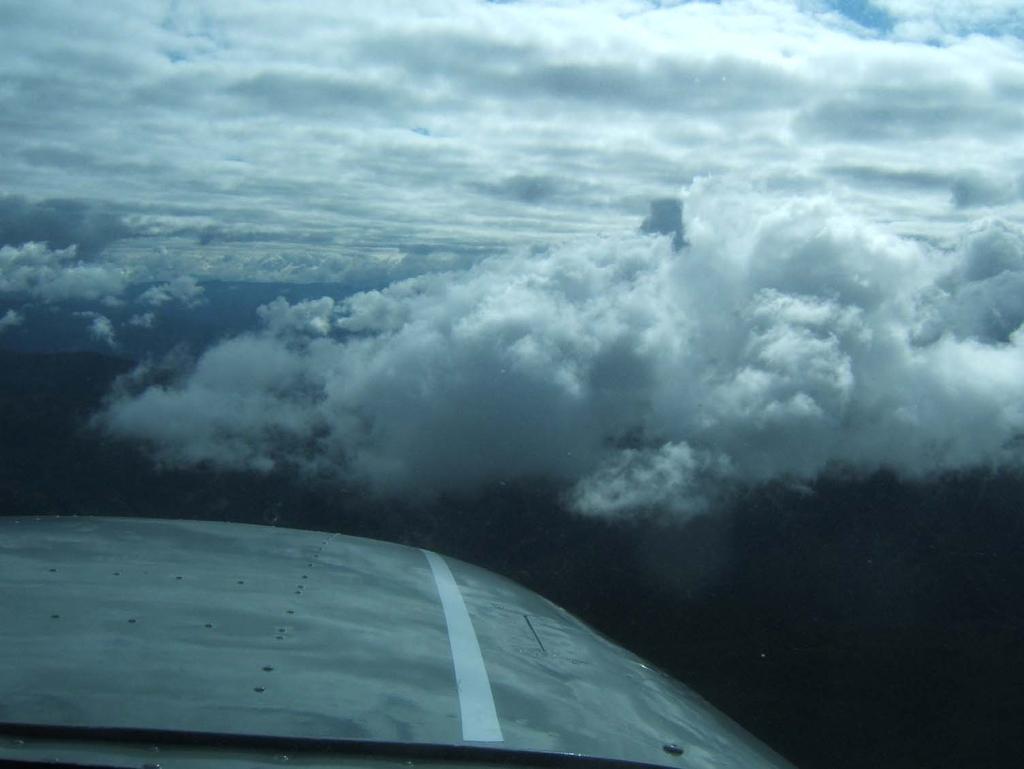
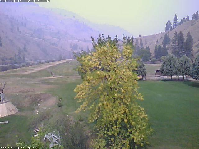
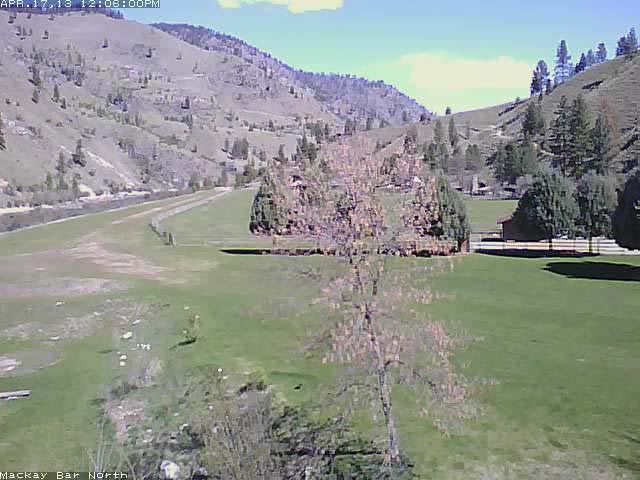
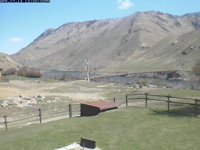
 BLM/USFS ROMAN Real time Observat`ion and Monitoring and Analysis Network Web Cam s: Johnson Cr.")
2 WEATHER SOURCES FSS WXBRIEF ASOS / METARS KSNT, KMYL, KLLJ, KSMN AOPA/NOAA Satellite, Radar, Surface, Winds, etc. NIFC / Faa.gov TFR s Noaa Automated Surface:METAR/ RAWS (Remote Automated WX Station) BLM/USFS ROMAN Real time Observat`ion and Monitoring and Analysis Network Web Cam s: Johnson Cr. Flying B, Stanley, McCall, Bogus Basin, MacKay Bar, Sulphur Cr. Commercial Operators: McCall Air, Arnold Aviation T-Craft Website News tab Bill McGlyns presentations

3 NOAA Surface Observation Map - Missoula / Regonal Stations
4 Moose Cr Raws Data
5
6
7
8
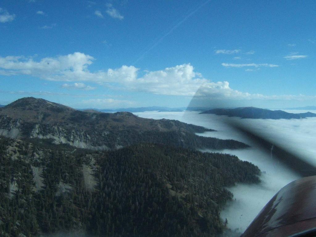
9 Flying B 5/22/08 9:14 AM
10
11
12
13
14
15
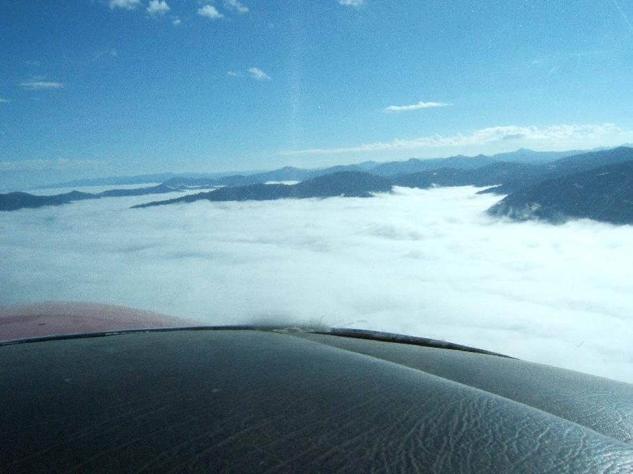
16 Lift Mountain / Canyon Weather - Orographic-Mechanical Lift as air flows over Mtns. - Thermal Lift Canyon Meteorology - Winds - Diurnal Effect - Flows Up in Day / Down in Evening (some exceptions) - Convergence Effect areas of confluence - Venturi Effect - Turbulence Fog (morning canyon fog common after a storm) Smoke
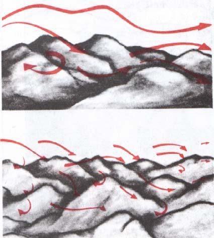
17 Orographic Lift over Mountains/Canyons

18 Thermal Lift over varying terrain
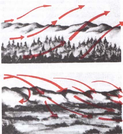
19 Thermal and Orographic Collide

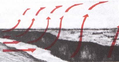
20 Diurnal Effect, Venturi, and Convergence Indian Cr. Pistol Cr. Indian Cr. Middle Fork Salmon

21 Big Cr. Drainage South Fork Salmon Monumental Cr. Middle Fork Salmon Johnson Cr. Marble Cr. Thermal, Orographic and Diurnal Effect effects combine and are different depending on direction of drainages We have a mixture N/S E/W and combinations of major drainages
22 Turbulence Slow Down to at or below Va Remember it s less with less weight Rule of Thumb ½ of % less gross weight). If at 10% less of max. gross weight, reduce Va 5%. Where to Expect it Lee side down wind side of Ridges Convergence areas in canyons Venturi areas wide to narrow canyon Over Area s of Thermal differences (shade/sun, trees/rock) Near Rotor, Lenticular, or Thunder Clouds Windy Conditions Mountain wave over rugged mountains or canyons
23
24
25
26
27

28 NASA Photo of Idaho Fires August 28, 2012

29 Halstead Fire from Stanley Airport

30 C Fire Recon Near the Needles

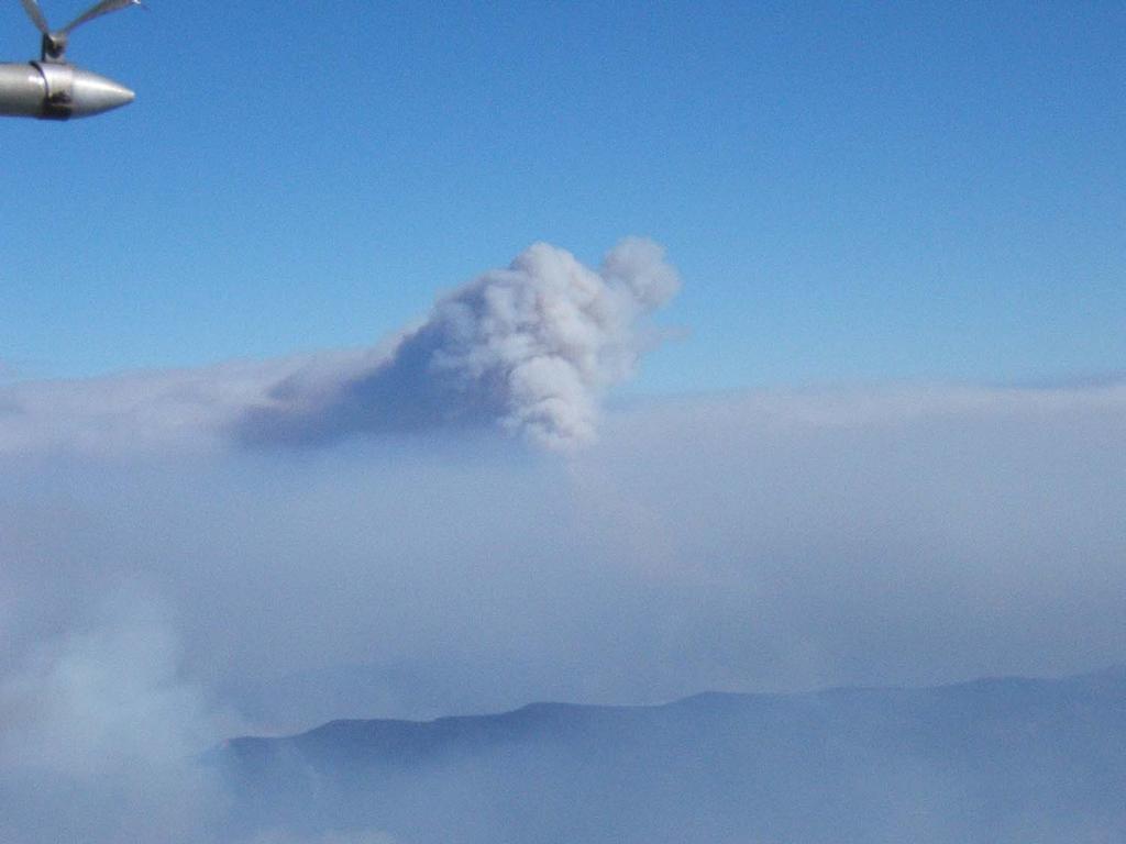
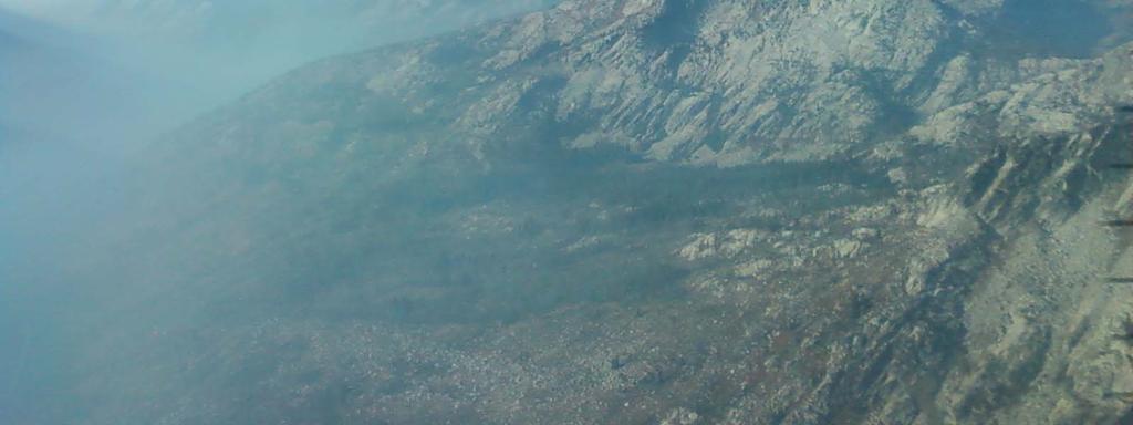
31 No TFR, but if you can see Avoid!
32 TFR s Trinity, Halstead and Mustang Fires KMAN to KSMN
33
34 TFR s Depicted TFR data may not be a complete listing. Pilots should not use the information on this website for flight planning purposes. For the latest information, call your local Flight Service Station at WX-BRIEF. Ask for: Abbreviated Briefing -- TFR updates.

35 FAA Description of Halstead TFR

36 Halstead Fire TFR Altitude: From the surface up to and including feet MSL 1330 to 0300 UTC Daily starting September 8 until further notice Frequency Telephone

37 TFR s Trinity, Halstead and Mustang Fires KMAN to KSMN
38 Avoiding the Halstead TFR KMAN to KSMN

39 Smoke over South Fork Salmon Pilot Peak barely visible

40 Chamberlain Basin about 2 miles out
41 Chamberlain Basin in pattern


42 Looking up South Fork toward Thunderbolt

43 East across South Fork to Rainbow Peak
44 Lick Creek Summit
45 Beaverslide Peak with Long Valley behind.

46 Three miles out, with McCall ASOS reporting 7 miles visibility
47 Smoke Flying Cautions VFR minimums can go to IFR w/o warning when flying with 1 to 3 miles visibility, you will not be able to detect change in smoke density. Plumes or banks of smoke can be very localized and quite dense. One to three miles visibility may be legal VFR but w/o adequate ground reference for navigation. August 21, a California pilot (Bill Scheck) accompanied by an experienced local back-country country instructor (Woody Woodruff) crashed near War Eagle Mountain as they turned up wrong drainage climbing out of Mackay Bar in smoke.
48 Cautions (continued) You will lose forward visibility as you climb into or descend through a smoke layer. Circling climb-out or descent over known landmark is best for maintaining spatial awareness and to avoid getting lost. Smoke is always more opaque looking into the sun. Caution when approach or departure requires a turn toward rising or setting sun.
Civil Air Patrol Auxiliary of the United States Air Force
 Mountain Flying Qualification Course Civil Air Patrol Auxiliary of the United States Air Force Mountain Flying Flying in Mountain Winds Determine direction and velocity of steady winds by observing dust,
Civil Air Patrol Auxiliary of the United States Air Force
 Mountain Flying Qualification Course Civil Air Patrol Auxiliary of the United States Air Force Mountain Weather Slopes Most U.S. mountain ranges are oriented north-south, while the prevailing winds are
APPI PPG LECTURE 5: FURTHER METEOROLOGY
 LECTURE 5: FURTHER METEOROLOGY Introduction: This lecture covers Further Meteorology and aims to give you more of an understanding of advanced weather conditions and patterns. However Meteorology is a
MOUNTAIN FLYING TEST
 MOUNTAIN FLYING TEST USE ANSWER SHEET (AF FORM 1584C, EXAM RECORD) ON THE LAST PAGE OF THIS TEST. 1. It is best to plan an early morning flight to take advantage of the air, which is: a. hotter and smoother.
Mountain Flying. the Mountains. challenging to do as long as we obey some long taught rules. and not above them?
 Mountain Flying l A Great Joy to Fly See and even land in the Mountains. l Mountain Flying is VERY Unforgiving l Mountain Flying is safe and very challenging to do as long as we obey some long taught rules.
Risk Management Plan NorCal Cross Country League and Sprint League
 Risk Management Plan NorCal Cross Country League and Sprint League Sprint League Rev 3-19-2019 All pilots are vetted before they can attend by me contacting their instructor to assess if they are skilled
Friday, August 3, 2018 Cobra flight #643, PIC #653, 2 landings Rio Grande, Santa Fe Baldy, Truchas, Jicartia
 Friday, August 3, 2018 Cobra flight #643, PIC #653, 2 landings Rio Grande, Santa Fe Baldy, Truchas, Jicartia Belen: 6:02 am Angel Fire: 9:08am Airtime: 3.1 Total PIC Time: 1714.8 Total Logged Time: 1736.0
Thursday, September 16, th Cobra flight, 15th solo flight Circled Ladron Peak
 Thursday, September 16, 2004 5th Cobra flight, 15th solo flight Circled Ladron Peak Launched 7:05am, Landing 8:50am Flight time: 1:45 hour (gpslog wheels up) Total time: 29:55 Dead Calm at first, 7mph
Friday, September 08, 2017 Cobra flight #597, PIC #610, 2 landings Mt Hossick, Hossick Lake, Spring Creek Falls, Gothic Mountain, Yule Lakes, Marble
 Friday, September 08, 2017 Cobra flight #597, PIC #610, 2 landings Mt Hossick, Hossick Lake, Spring Creek Falls, Gothic Mountain, Yule Lakes, Marble Pagosa Springs: 7:35 am Marble: 10:39 am Today s Airtime:
Mountain Flying. What s Different About Flying in the Mountains?
 Why? The mountains are a beautiful place to visit There are many out-of-the-way vacation spots that are hard to reach by car but easy to reach by plane (e.g. Big Bear, Mammoth) Learning to fly in the mountains
MET 200 Lecture 11 Local Winds. Last Lecture: Forces. Review of Forces. Balance of Forces
 MET 200 Lecture 11 Local Winds Last Lecture: Forces Scales of Motion Eddies Sea Breeze Mountain-Valley Circulations Chinook - Snow Eater Drainage Wind - Katabatic Wind 1 2 Review of Forces 1. Pressure
Exercise: Satellite Imagery Analysis. 29 June 2016 Japan Meteorological Agency
 Exercise: Satellite Imagery Analysis 29 June 2016 Japan Meteorological Agency Contents 1. Fog/Stratiform Cloud 2. Cb (Cumulonimbus)/Cg (Cumulus congestus) 3. Upper-level Flow Jet stream, upper trough,
OPERATIONAL USE OF A WIND PROFILER FOR AVIATION METEOROLOGY ABSTRACT
 OPERATIONAL USE OF A WIND PROFILER FOR AVIATION METEOROLOGY Miguel Angel Pelacho, Darío Cano, Eugenio Ayensa Spanish Agency of Meteorology (AEMET) Parque del Buen Retiro, Apdo. 285, 28080-MADRID E-mail:
DIRECCION DE PERSONAL AERONAUTICO DPTO. DE INSTRUCCION PREGUNTAS Y OPCIONES POR TEMA
 MT DIREION DE PERSONL ERONUTIO DPTO. DE INSTRUION PREGUNTS Y OPIONES POR TEM 1 TEM: 0643 OM-RT - Weather - hap. 6 OD_PREG: PREG20098600 (5301) PREGUNT: Every physical process of weather is accompanied
Mountain Fury Mountain Search Flying Course Syllabus Fourth Sortie : High Altitude Search
 Mountain Fury Mountain Search Flying Course Syllabus Fourth Sortie : High Altitude Search Objectives 1. Develop trainee's proficiency in planning and execution of mountain search sorties. 2. Develop trainee's
LOCAL WINDS. Prof. Stephan De Wekker Department of Env. Sciences Guest lecture EVSC 1300
 LOCAL WINDS Prof. Stephan De Wekker (dewekker@virginia.edu) Department of Env. Sciences Guest lecture EVSC 1300 SEA BREEZE 980 mb 990 mb 1000 mb LAND BREEZE The convergence of two lake breezes and
Stormy Weather. tropopause. z i
 Stormy Weather tropopause z i z x High Low Stormy Weather Tropopausez Venting by thunderstorms y Venting by fronts x Stormy Weather Height, z tropopause clouds clouds z i BL n cold air warm air z i BL
P2.17 OBSERVATIONS OF STRONG MOUNTAIN WAVES IN THE LEE OF THE MEDICINE BOW MOUNTAINS OF SOUTHEAST WYOMING
 P2.17 OBSERVATIONS OF STRONG MOUNTAIN WAVES IN THE LEE OF THE MEDICINE BOW MOUNTAINS OF SOUTHEAST WYOMING Larry D. Oolman 1, Jeffrey R. French 1, Samuel Haimov 1, David Leon 1, and Vanda Grubišić 2 1 University
Local Winds. Please read Ahrens Chapter 10
 Local Winds Please read Ahrens Chapter 10 Scales of Motion Microscale: meters Turbulent eddies Formed by mechanical disturbance or convection Lifetimes of minutes Mesoscale: km s to 100 s of km s Local
Early morning fog. Courtesy of NOAA, Image Source: Earth Science World Image Bank
 Weather Clouds Early morning fog Courtesy of NOAA, Image Source: Earth Science World Image Bank Beach Fog Bruce Molnia, Terra Photographics, Image Source: Earth Science World Image Bank Stratus Clouds
Basic Mountain Flying
 Advanced Manoeuvres Basic Mountain Flying This training introduces students to the principles of basic mountain flying and further develops their experience and understanding of operating near terrain
OBSTACLE DEPARTURE PROCEDURES Part 3
 OBSTACLE DEPARTURE PROCEDURES Part 3 In the last issue, I promised to discuss Visual Climb Over Airport (VCOA) departure procedures and to show examples of more complex ODPs than was discussed in that
Mountain Fury Mountain Search Flying Course Syllabus
 Mountain Fury Mountain Search Flying Course Syllabus Goals 1. Pilots who complete this program will be able to perform with precision and confidence all of the tasks and flight maneuvers required for safe
1. Sign in personnel, aircraft, and vehicles. Use mission flow chart
 A. PRE-FLIGHT BRIEFING 1. Sign in personnel, aircraft, and vehicles. Use mission flow chart 2. Discuss how the scanner watches for other aircraft during departure, cruise, and approach. 3. Have the trainee
A-License Information Packet
 A-License Information Packet 1. Objective The objective of this packet is to review several parts of the United States Parachute Association (USPA) A License Proficiency Card and to learn additional aspects
Aviation Merit Badge Knowledge Check
 Aviation Merit Badge Knowledge Check Name: Troop: Location: Test Score: Total: Each question is worth 2.5 points. 70% is passing Dan Beard Council Aviation Knowledge Check 1 Question 1: The upward acting
I2101 SIMULATOR ABBREVIATED CHECKLIST
 WORKSHEET I2101 SIMULATOR ABBREVIATED CHECKLIST Planned Route: Takeoff: KNSE, RWY 32 Altitude: 12,000 Route: PENSACOLA NORTH MOA Special Syllabus Requirements: -None Discuss Items a. Departures Four basic
South African Powered Paragliding Theoretical Knowledge Test
 South African Powered Paragliding Theoretical Knowledge Test Last Updated 5 February 2002 Question 1: (PTE) Explain what you understand about the Propeller Torque Effect, including its causes and effects
2 November WSI Hubcast VERSION 3.5 RELEASE NOTES
 2 November 2016 WSI Hubcast VERSION 3.5 RELEASE NOTES THE WEATHER COMPANY WSI Hubcast 2 2 WSI HUBCAST 3.5 RELEASE NOTES This document describes the major changes introduced with version 3.5 of the WSI
18 Flight Hazards over High Ground
 18 Flight Hazards over High Ground meteorology 18.1 Mountain Effect on Fronts When a warm front passes a mountain range, the air, is lifted over the mountain and will strengthen the formation of cloud
The total precipitation (P) is determined by the average rainfall rate (R) and the duration (D),
 is determined by the average rainfall rate (R) and the duration (D),") Orographic precipitation Common ingredients of heavy orographic precipitation The total precipitation (P) is determined by the average rainfall rate (R) and the duration (D), P = RD. (1) The rainfall rate
Orographic precipitation Common ingredients of heavy orographic precipitation The total precipitation (P) is determined by the average rainfall rate (R) and the duration (D), P = RD. (1) The rainfall rate
Climbs, descents, turns, and stalls These are some of the maneuvers you'll practice, and practice, and practice By David Montoya
 Climbs, descents, turns, and stalls These are some of the maneuvers you'll practice, and practice, and practice By David Montoya Air work stalls, steep turns, climbs, descents, slow flight is the one element
Winter Flying Safety. October, 2015
 Winter Flying Safety October, 2015 Winter Flying: Phases of Flight Preflight (including Wx briefing) Taxi & Takeoff Enroute Approach & Landing Night Currency Due to shorter days, many flights may be completed
SAMPLE OF WRITTEN EXAM QUESTIONS
 CIVIL AVIATION AGENCY THE REPUBLIC OF SLOVENIA SAMPLE OF WRITTEN EXAM QUESTIONS LICENCE PARAGLIDING PILOT December 2018 ELEMENTARY AERODYNAMICS, FLYING THEORY AND TECHNIQUE (A) ELEMENTARY AERODYNAMICS,
An Investigation of Dynamic Soaring and its Applications to the Albatross and RC Sailplanes
 An Investigation of Dynamic Soaring and its Applications to the Albatross and RC Sailplanes Christopher J. Lee Senior Project June 5, 2011 Aerospace Engineering California Polytechnic State University
BGA BRONZE ENDORSEMENT. Theoretical Knowledge Syllabus. V2 Nov 11
 BGA BRONZE ENDORSEMENT Theoretical Knowledge Syllabus Syllabus for BGA Bronze Endorsement Theoretical Knowledge Syllabus Air Law and Recommended Practices Airmanship Principles of flight 1 - lift, drag
PROCEDURES GUIDE CESSNA 172N SKYHAWK
 PROCEDURES GUIDE CESSNA 172N SKYHAWK THESE PROCEDURES ARE DESIGNED TO PROVIDE STANDARDIZED METHODS UNDER NORMAL CONDITIONS. AS CONDITIONS CHANGE, THE PROCEDURES WILL NEED TO BE ADJUSTED. PASSENGER BRIEFING
Ongoing research in Hong Kong has led to improved wind shear and turbulence alerts
 Ongoing research in Hong Kong has led to improved wind shear and turbulence alerts (published in the International Civil Aviation Organization (ICAO) Journal, Volume 58, Number 2, March 2003) Located in
Outline. Wind Turbine Siting. Roughness. Wind Farm Design 4/7/2015
 Wind Turbine Siting Andrew Kusiak 2139 Seamans Center Iowa City, Iowa 52242-1527 andrew-kusiak@uiowa.edu Tel: 319-335-5934 Fax: 319-335-5669 http://www.icaen.uiowa.edu/~ankusiak Terrain roughness Escarpments
I2103 WORKSHEET. Planned Route: Takeoff: KNSE, RWY 32 Altitude: 12,000 Route: RADAR DEPARTURE. Syllabus Notes None
 Planned Route: Takeoff: KNSE, RWY 32 Altitude: 12,000 Route: RADAR DEPARTURE Syllabus Notes None I2103 WORKSHEET Special Syllabus Requirements Proceed direct to homefield using any available NAVAID. Discuss
Wind: Small-scale and Local Systems
 Wind: Small-scale and Local Systems Scales of Atmospheric Motion Atmospheric motions/phenomena occur on many diverse spatial and temporal scales. Weather forecasters tend to focus on Mesoscale and synoptic
VI.B. Traffic Patterns
 References: FAA-H-8083-3; FAA-H-8083-25; AC 90-42; AC90-66; AIM Objectives Key Elements Elements Schedule Equipment IP s Actions SP s Actions Completion Standards The student should develop knowledge of
Global Weather Patterns
 Global Weather Patterns AZ State Standards Concept 2: Energy in the Earth System (Both Internal and External) Understand the relationships between the Earth s land masses, oceans, and atmosphere. PO 2.
Student Pilot Written Presolo Test for Chicago Glider Club September 1, 2012
 Student Pilot Written Presolo Test for Chicago Glider Club September 1, 2012 Student name and date Instructor name and review date Note: These questions are designed to satisfy FAR 61.87 (b) for local
VI.B. Traffic Patterns
 References: FAA-H-8083-3; FAA-H-8083-25; AC 90-42; AC90-66; AIM Objectives Key Elements Elements Schedule Equipment IP s Actions SP s Actions Completion Standards The student should develop knowledge of
Belen: 6:13 am Belen: 10:20 am Today s Airtime: 4.1 Total PIC Time: Total Logged Time:
 Saturday, May 19, 2018 Cobra flight #631, PIC #644, 2 landings Balls, Mt Taylor, Cerro Alesna, Cliff House, Blue Hole Spring, Banco de la Casa, Red Mesa Belen: 6:13 am Belen: 10:20 am Today s Airtime:
Wind Project Siting and Permitting Blaine Loos
 Wind Project Siting and Permitting Blaine Loos Energy Project Analyst Center for Wind Energy at James Madison University Wind Project Siting and Permitting The Energy in Wind Resource Assessment (Macro-siting)
FAA-S-ACS-6 June 2016 Private Pilot Airplane Airman Certification Standards. Task ACS Settings
 FAA-S-ACS-6 June 2016 Private Pilot Airplane Airman Certification Standards Cessna 172: mixture rich, carb heat out if below the green arc. Clearing Turns all manuevers! Task ACS Settings Traffic Pattern
Title: Gravity wave over flat terrain.
 Title: Gravity wave over flat terrain. Author: Daniel L. Johnson (MD), Mayo Clinic Health System, drdan@wwt.net Abstract: Wave is everywhere throughout the atmosphere, whereever shear exists. Standing
TECHNIQUES FOR OFF AIRPORT OPERATIONS
 Off Airport Ops Guide TECHNIQUES FOR OFF AIRPORT OPERATIONS Note: This document suggests techniques and procedures to improve the safety of off-airport operations. It assumes that pilots have received
Meteorology. Iain Darby NAPC/PH-NSIL IAEA. International Atomic Energy Agency
 Meteorology Iain Darby NAPC/PH-NSIL International Atomic Energy Agency Good Weather Information Accurate weather forecasts play a vital role in all aviation activity It is required by law in many countries
Gleim Instrument Pilot FAA Knowledge Test Prep 2018 Edition, 1st Printing Updates March 2018
 Page 1 of 6 Gleim Instrument Pilot FAA Knowledge Test Prep 2018 Edition, 1st Printing Updates March 2018 NOTE: Text that should be deleted is displayed with a line through it. New text is shown with a
Takeoff Performance. A 1 C change in temperature from ISA will increase or decrease the takeoff ground roll by 10%.
 The precise pilot does not fly by rules of thumb, axioms, or formulas. But there are times when knowledge of an approximate way to calculate things or knowledge of a simple rule can pay big dividends.
Avalanche Problem Essentials Wind Slabs. Development
 1 Avalanche Problem Essentials Wind Slabs This document is part of Decision Making in Avalanche Terrain: a fieldbook for winter backcountry users by Pascal Haegeli, Roger Atkins and Karl Klassen and provides
1. You may request a contact approach if there is 1 SM flight visibility and you can operate clear of clouds to the destination airport.
 HOLDING AND INSTRUMENT APPROACHES CONTACT AND VISUAL APPROACHES 1. You may request a contact approach if there is 1 SM flight visibility and you can operate clear of clouds to the destination airport.
Accident Prevention Program
 Accident Prevention Program Wind Shear "Tonto 55, final controller, how do you read...?" "55, loud and clear." This has been a good flight thought the Instructor Pilot (IP) as the pilot in front smoothly
Weather and Meteorology Sheet 1 Adiabatic Processes The definition is:- A system where heat is neither added nor taken from a process.
 Weather and Meteorology Sheet 1 Adiabatic Processes The definition is:- A system where heat is neither added nor taken from a process. The expansion and compression of gases are adiabatic. Consider the
FLYING OPERATIONS. Hard Landing
 Hard Landing The circling approach takes place close to the ground, at low speed, and in poor weather. Without doubt it is one of aviation s most difficult procedures. How can you reduce the risks? 34
Cessna 172S Skyhawk Standardization Manual
 Cessna 172S Skyhawk Standardization Manual This manual is to be utilized in conjunction with the manufacturers approved POH/ AFM and the Airplane Flying Handbook (FAA-H-8083-3A). This manual should be
Mountain Forced Flows
 Mountain Forced Flows Jeremy A. Gibbs University of Oklahoma gibbz@ou.edu February 3, 2015 1 / 45 Overview Orographic Precipitation Common Ingredients of Heavy Orographic Precipitation Formation and Enhancement
SOPs for Morgan County Airport 42U
 SOPs for Morgan County Airport 42U Morgan County Airport is located in the unincorporated township of Mountain Green Utah. It is approximately eight miles west of the town of Morgan, Utah. It is a public
Descend Pilot s Discretion
 Page 1 of 9 Descend Pilot s Discretion By Chris Reed, CFI, CFII, MEI Airplanes are one of only a few types of vehicles that can truly operate in three dimensions. Because of this, the pilot must be able
Meteorology. Circle the letter that corresponds to the correct answer
 Chapter 4 Worksheet 3 Meteorology Name: Circle the letter that corresponds to the correct answer 1) Natural convection and turbulence are most likely to occur when: a) temperature decreases rapidly with
ENVIRONMENTAL PHYSICS
 ENVIRONMENTAL PHYSICS Atmospheric Stability An understanding of why and how air moves in the atmosphere is fundamental to the prediction of weather and climate. What happens to air as it moves up and down
2. Study Setting. This section describes the study domain, major terrain features, land use, meteorology, and regional air quality and visibility.
 2. Study Setting This section describes the study domain, major terrain features, land use, meteorology, and regional air quality and visibility. 2.1 The Southwestern United States Figure 2-1 shows a terrain
Wind Power. Kevin Clifford METR 112 April 19, 2011
 Wind Power Kevin Clifford METR 112 April 19, 2011 Outline Introduction Wind Turbines Determining Wind Power Output The Price of Wind Power Wind Power Availability across the World and US California Wind
Historical and Current Climate in the Rio Grande National Forest Area. Peter Goble Nolan Doesken 10/19/2016
 Historical and Current Climate in the Rio Grande National Forest Area Peter Goble Nolan Doesken 10/19/2016 Geographic Orientation Geographic Orientation Geographic Orientation Rio Grande National Forest
Feature Articles. Annyong ha shimnikka
 Acoustics Shock Vibration Signal Processing October 2002 Newsletter Annyong ha shimnikka Feature Articles Vibration waves are one of the mechanisms by which nature displays its awesome power. Mountain
A Guide To Aviation Weather
 A Guide To Aviation Weather Richard D. Clark, Ph.D. Professor of Meteorology Student Assistants: Keith Liddick and Sam DeAlba Department of Earth Sciences Millersville University 16 NOV 2005 Outline Icing
Basic Instrument Scan. T6BDriver.com Created: 4 Feb 2016 Updated: 28 Aug 2016
 Basic Instrument Scan T6BDriver.com Created: 4 Feb 2016 Updated: 28 Aug 2016 Information Sources Attitude Instrument Flying Control-Performance Method Scanning (Cross-check) Scanning Errors Scan Pattern
Condor Cross-Country Training Program Redux
 Condor Cross-Country Training Program Redux Frank Paynter Last year about this time I wrote about the training syllabus I use for crosscountry instruction using Condor. I have been providing training in
Civil Air Patrol Auxiliary of the United States Air Force
 Mountain Flying Qualification Course Civil Air Patrol Auxiliary of the United States Air Force DENSITY ALTITUDE Pressure Altitude Pressure Altitude: Absolute altitude corrected for non-standard atmospheric
Local and Global Winds
 PART 2 Wind Local and Global Winds Wind is the horizontal movement of air. All wind is caused by air pressure differences due to the uneven heating of Earth's surface, which sets convection currents in
Table of Contents. 1. Training in the vicinity of the airfield. 2 Weather and Gliding
 Table of Contents Preface to the third edition 2 About the Author 3 Foreword by Ingo Renner 4 Foreword by Michael Sommer 5 Content at a glance 6-7 To my family / The use of icons 8 1. Training in the vicinity
13.6 AIRBORNE RADAR OBSERVATIONS OF BREAKING WAVES/ROTORS IN THE LEE OF THE MEDICINE BOW MOUNTAINS IN SE WYOMING, USA
 13.6 AIRBORNE RADAR OBSERVATIONS OF BREAKING WAVES/ROTORS IN THE LEE OF THE MEDICINE BOW MOUNTAINS IN SE WYOMING, USA Jeffrey R. French 1 *, Samuel Haimov 1, Larry Oolman 1, Vanda Grubišić 2, and Dave
Clouds and More Clouds AOSC 200 Tim Canty. Class Web Site: Lecture 12 Oct Hot air rises!
 Clouds and More Clouds AOSC 200 Tim Canty Class Web Site: http://www.atmos.umd.edu/~tcanty/aosc200 Topics for today: How to make clouds pt 1. Lecture 12 Oct 4 2018 1 Hot air rises! What happens then? 2
Piper PA Seminole 1. Standardization Manual
 Piper PA-44-180 Seminole Standardization Manual This manual is to be utilized in conjunction with the manufacturers approved POH/AFM and the Airplane Flying Handbook (FAA-H-8083-3A). This manual should
Vertical Motion and Atmospheric Stability
 Lesson 4 Vertical Motion and Atmospheric Stability This lesson describes the vertical structure of the atmosphere, atmospheric stability and the corresponding vertical motion. Adiabatic diagrams are introduced
Low Flying Introduction
 Advanced Manoeuvres Low Flying Introduction Commonly, low flying refers to any flight at or below 500 feet agl that may be practised only in designated low flying zones. By maintaining good situational
Meteorology. Circle the letter that corresponds to the correct answer
 Chapter 6 Worksheet 2 Meteorology Name: Circle the letter that corresponds to the correct answer 1) A steep pressure gradient: a. produces light winds. b. produces strong winds. c. is only possible in
Small Footprint Topo-Bathymetric LiDAR
 May 8, 2013 Small Footprint Topo-Bathymetric LiDAR PNAMP Remote Sensing Forum Russ Faux, Co-CEO, WSI Amar Nayegandhi, Manager of Elevation Technologies, Dewberry Colin Cooper, Senior Analyst, WSI Watershed
Mandatory Briefing Bardufoss (ENDU)
") Mandatory Briefing Bardufoss (ENDU) Introduction Norwegian CAA has reconsidered and reclassified Bardufoss aerodrome from Cat C to Cat B with the following requirements to be completed: An aerodrome briefing
Mandatory Briefing Bardufoss (ENDU) Introduction Norwegian CAA has reconsidered and reclassified Bardufoss aerodrome from Cat C to Cat B with the following requirements to be completed: An aerodrome briefing
Cessna 152 Standardization Manual
 Cessna 152 Standardization Manual This manual is to be utilized in conjunction with the manufacturers approved POH/ AFM and the Airplane Flying Handbook (FAA-H-8083-3A). This manual should be used as a
Low Level Wind Shear: Using Smoke Plumes for Guidance
 Low Level Wind Shear: Using Smoke Plumes for Guidance John Dutcher Dutcher Safety & Meteorology Services www.johndutcher.com Low Level Wind Shear Wind shear is defined as any rapid change in wind direction
Night Flying. Objective To operate the aircraft safely both on the ground and in the air at night.
 Instrument Flying Night Flying Flying VFR at night is inherently more risky than flying VFR during the day. These risks and threats can, and must, be managed carefully with good preparation and instrument
Gleim ATP FAA Knowledge Test 2011 Edition, 1st Printing Updates December 6, 2010
 Page 1 of 8 Gleim ATP FAA Knowledge Test 2011 Edition, 1st Printing Updates December 6, 2010 NOTE: Text that should be deleted from the outline is displayed as struck through with a red background. New
Exploring Wind Energy
 2013-2014 Exploring Wind Energy Student Guide SECONDARY Introduction to Wind What is Wind? Wind is simply air in motion. It is produced by the uneven heating of the Earth s surface by energy from the sun.
PRIVATE PILOT MANEUVERS Practical Test Standards FAA-S A
 PRIVATE PILOT MANEUVERS Practical Test Standards FAA-S-8081-15A Special Emphasis Areas Examiners shall place special emphasis upon areas of aircraft operation considered critical to flight safety. Among
AVIATION SAFETY BULLETIN
 AVIATION SAFETY BULLETIN Issued: 1 Apr 217 Ref: By: Area Affected: Reason: Effective: Pages: ASB.3.217 Director: Safety and Quality Flight Operations: Rotor wing EASA Notice Loss of Control Immediate 2
Bald Eagle Ridge. Bald Eagle Ridge. How to Get There. The World s Longest Diamond Mine. The World s Longest Diamond Mine. From Toronto.
 Bald Eagle Ridge The World s Longest Diamond Mine Bald Eagle Ridge The World s Longest Diamond Mine 320 320 o 350 o Williamsport, North End How to Get There 335 o 295 o 800 800 km Altoona Ridge Soaring
Glide Calculator SGS (e-version Jan 2007)
") PILOT's OPERATING INSTRUCTIONS Glide Calculator SGS 1-26 (e-version 1.0 26 Jan 2007) Figure 1 A. AMOUNT of altitude you need to accomplish your plan. B. Statute miles-to-go to your destination. C. Mileage
PILOT's OPERATING INSTRUCTIONS Glide Calculator SGS 1-26 (e-version 1.0 26 Jan 2007) Figure 1 A. AMOUNT of altitude you need to accomplish your plan. B. Statute miles-to-go to your destination. C. Mileage
Scales of Atmospheric Motion
 Lecture 12 Local Wind Systems Scales of Atmospheric Motion Small turbulent eddies (swirls) A synoptic eddy 1 Coriolis Effect The larger the scale, the longer the life time. Wind shear and turbulent eddy
Saturday, May 28, th Cobra flight, 57th solo Cruise up Rio Puerco, PPC, Tetilla 2 landings
 Saturday, May 28, 2005 47th Cobra flight, 57th solo Cruise up Rio Puerco, PPC, Tetilla 2 landings First Launch: 6:05am Final Landing: 10:25am Today s airtime 4:20 XC distance 213 miles Total logged time:
CHAPTER 9. More on meteorology
 CHAPTER 9 More on meteorology 1). Atmospheric Pressure Atmospheric pressure is the pressure with which the atmosphere acts downwards due to its weight. Pressure decreases with altitude because the column
PHSC 3033: Meteorology Stability
 PHSC 3033: Meteorology Stability Equilibrium and Stability Equilibrium s 2 States: Stable Unstable Perturbed from its initial state, an object can either tend to return to equilibrium (A. stable) or deviate
High resolution wind fields over the Black Sea derived from Envisat ASAR data using an advanced wind retrieval algorithm
 High resolution wind fields over the Black Sea derived from Envisat ASAR data using an advanced wind retrieval algorithm Werner Alpers (1), Alexis Mouche (2), Andrei Yu. Ivanov (3), and Burghard Brümmer
BFGC Soaring & Cross Country
 Lecture 2 Meteorology: Basic Weather Forecasting: Websites to use Pressure Charts Fronts Cloudbase Forecast Hidden Meanings Thermal Strength Trigger Temperature Advantageous Route Planning Principles of
Pressure and Density Altitude
 Pressure and Density Altitude Reference Sources Pilot s Handbook of Aeronautical Knowledge o Pages 9-1 to 9-4, Aircraft Performance o Pages 9-20 to 9-21, Density Altitude Charts Study Questions 1. Where
Cloud Development and Forms
 Chapter 6 Lecture Understanding Weather and Climate Seventh Edition Cloud Development and Forms Redina L. Herman Western Illinois University Mechanisms That Lift Air When air lifts, clouds develop and
Questionnaire for the theoretical part of education in skydiving. Meteorology
 1. At which approximately altitude is the atmospheric pressure ½ of the pressure at MSL (mean sea level)? a) 1.500m MSL b) 2.000m MSL c) 5.500m MSL d) 7.000m MSL 2. The rate of oxygen in the air is 21%.