Navigation for Offshore Sailing
|
|
|
- Godfrey Townsend
- 6 years ago
- Views:
Transcription
1 Navigation for Offshore Sailing
2 This new ship here, is fitted according to the reported increase of knowledge among mankind. Namely, she is cumbered, end to end, with bells and trumpets and clocks and wires which, it has been told to me, can call Voices out of the air or the waters to con the ship while her crew sleep. But sleep thou lightly It has not yet been told to me that the Sea has ceased to be the Sea - Rudyard Kipling
3 Outline Review Nautical Chart types and scales Buoyage System (IALA Region B) Light characteristics Rules of the Road Tidal currents Basic navigational inputs Basic Navigation Skills Planning a course to steer Estimating your position Knowing where you are Inshore Pilotage

4 Geographical Coordinate System
 Disadvantages Chart scale not constant with position Distance between lines of latitude are exaggerated in polar")
5 Mercator Projection Advantages Easy to use rectangular grid Straight lines cross Meridians at constant angle (Rhumb Lines) Disadvantages Chart scale not constant with position Distance between lines of latitude are exaggerated in polar regions
")
")
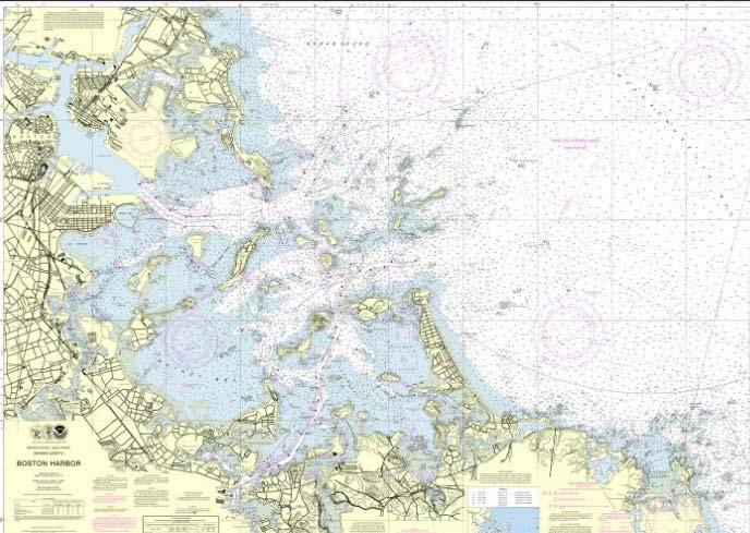
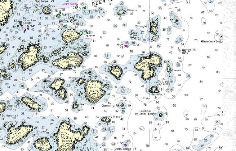
6 Nautical Chart Scales Boston Harbor Large scale (1/25,000) Covers small area Newport to Bermuda Small scale (1/1,058,400) Covers large area
7
8
9 8 Ways to Identify a Lateral Mark Color (Green, Red) Buoy shape (Cylindrical, Conical) Dayboard (Green Square, Red Triangle) Topmark (Cylinder, Cone (point upward)) Light Color (Green, Red) Reflector Color (Green, Red) ID Number (Odd, Even) Sound (Gong (clang), Bell (ding)) Light Rhythms Fixed Occulting Isophase Flashing Quick Group or Composite Group Morse Code Fixed and Flashing Alternating

10 Buoyage Example IALA Region B
11
12
13 Set Tidal Currents Direction in which an object will travel at a given time if carried by the tidal current NOTE: this is opposite to the way wind is represented Drift The distance that an object will travel in a given time if carried by the tidal current Current (or Flow) Ebb The speed at which an object will travel at a given time if carried by the tidal current Refers to the tidal current in the falling phase of the tide Flood Refers to the tidal current in the rising phase of the tide
14 Current Table

15 Current Chart
16 Tidal Currents Rule of Thirds and 50/90 Rule Slack Water Max Current C (kt) Slack Water Hour 1 Hour 2 Hour 3 Hour 4 Hour 5 Hour 6 Drift 1/3 C (nm) 2/3 C (nm) 3/3 C (nm) 3/3 C (nm) 2/3 C (nm) 1/3 C (nm) Current (kt) 0.5C.9C C.9C.5C 0
17 Basic Navigational Inputs Your eyes Look around Orient the chart Relate your visible surroundings to the chart Compass True Heading Variation Magnetic Heading Deviation Compass Heading Log / Clock Speed Distance run Depth sounder Local depth
18 Outline Review Nautical Chart types and scales Buoyage System (IALA Region B) Light characteristics Rules of the Road Tidal currents Basic navigational inputs Basic Navigation Skills Planning a course to steer Estimating your position Knowing where you are Inshore Pilotage
19 Planning a Course to Steer Course to Steer is what you tell the helm to steer By reference to a clear, distant, motionless visual mark (best) By reference to the compass at the helm (less good) By reference to wind ( e.g., close hauled, broad reach) Use your chart plotter or parallel rulers on the chart to determine the direction to your destination This will be a True Course Professional navigators always plot True Course on the chart Some navigators prefer to plot Magnetic Course Correct for leeway and current to get Course to Steer (in degrees True) Correct for Variation and Deviation to get Course to Steer (in degrees Per Steering Compass, or PSC ) Whatever system you use, be clear and consistent You will be reading your chart when you are tired and seasick Others will be reading your chart under similar conditions
20 Plotting your Desired Course Arrowhead indicates a course Prefix C indicates Course Suffix T or M indicates True or Magnetic If there is no leeway or current, you can correct this for Variation and Deviation and hand up to the helm as Course to Steer Note the compass course steered in the ship s log
 Note the compass course steered in the ship s log")
21 Correcting for Leeway (no current) Wind Remember: This is the course you are trying to make good through the water Estimate your leeway angle (in this case 9 o ) If there is no current, correct for Variation and instruct the helm to steer 068 o on the binnacle compass (corrected for Deviation if necessary) Note the compass course steered in the ship s log (068 o PSC)
22 Wind Correcting for Current With current, we must distinguish between the Course we make good through the water and our Desired Track (or Track) The Track is often called the Course Made Good Over the Bottom Since the Track will be different than our Course made good through the water, we label it differently
23 Wind Correcting for Current Draw a vector with the estimated 1 hour current set (direction) and drift (distance) Label it as a current vector
24 Wind Correcting for Current Connect the current vector to the desired track using the estimated distance the boat will travel through the water in the same interval (1 hour) Note: You don t have to use 1 hour, it just makes the math easier
25 Wind Correcting for Current Label the desired course made good through the water
26 Wind Correcting for Current Correct for leeway and label as course to steer (if desired) Correct for variation and deviation and hand up to the helm Note compass course steered (057 o PSC) in ship s log
27 Wind Correcting for Current Alternate Labeling Technique Construct current correction triangle on a separate plotting sheet or clear area on chart Plot Course to Steer directly on Track
28 Outline Review Nautical Chart types and scales Buoyage System (IALA Region B) Light characteristics Basic navigational inputs Basic Navigation Skills Planning a course to steer Estimating your position Knowing where you are Inshore Pilotage
29 The Ship s Log Time Log Course Weather Remarks PSC NNW10, 1005mb, Fair GPS Fix, GPS OFF
30 The Ship s Log Time Log Course Weather Remarks PSC 062 PSC NNW10, 1005mb, Fair N10 GPS Fix, GPS OFF, Close hauled on Port Tack PSC N10, 1005mb, Fair Close hauled, Port
31 The Ship s Log Time Log Course Weather Remarks PSC 062 PSC NNW10, 1005mb, Fair N10 GPS Fix, GPS OFF, Close hauled on Port Tack PSC N10, 1005mb, Fair Close hauled, Port PSC N10, 1005mb, Fair Tacked, Close hauled, Stbd
32 The Ship s Log Time Log Course Weather Remarks PSC 062 PSC NNW10, 1005mb, Fair N10 GPS Fix, GPS OFF, Close hauled on Port Tack PSC N10, 1005mb, Fair Close hauled, Port PSC N10, 1005mb, Fair Tacked, Close hauled, Stbd Where Are We? What do we do next?
33 Estimating Your Position Plot a Dead Reckoning Position Course steered and distance logged Use ship s log as the source of information Plot an Estimated Position Position adjusted for leeway and current
34 Plotting a Dead Reckoning Position. GPS 1900
35 Plotting a Dead Reckoning Position. GPS 1900 From 1900 to 2000, compass course steered was 062 o PSC and log difference is 6nm ( ) Course steered was 046 o T (Remember: TVMDC)
36 Plotting a Dead Reckoning Position GPS 1900 Draw a line from the 1900 position, along the course steered (046 o T) and mark a point at the distance traveled (6nm) Label this as your 2000 DR position NOTE: DR position is not corrected for leeway or current
37 Plotting an Estimated Position. GPS 1900 Plot a line representing your Course Made Good through the water (i.e., the course steered, adjusted for leeway) In this case it is 046 o T + 9 o = 055 o T Make the length of the line the distance traveled from (6nm)
38 Plotting an Estimated Position GPS 1900 From the end of the Course Made Good through the water, plot a line representing the estimated current set and drift over the time period In the absence of any new information, use the same set and drift that you used to calculate your course to steer Label the resulting Estimated Position with the time
39 Plotting an Estimated Position GPS 1900 Since nothing changed between 2000 and 2100, you can simply lay your plotting tool along a line between the 1900 GPS Fix and the 2000 EP and mark the 2100 EP along the extension of that line
40 Plotting an Estimated Position The distance between the 2000 EP and the 2100 EP should be the same as between the 1900 GPS Fix and the 2000 EP
41 Assess the Situation (predicted) On the present tack, the helm is steering 322C (306T) Accounting for leeway, the boat is making 297T through the water at ~6 knots Even accounting for current, this looks like a bad tack
42 Plan a Course to Steer Instruct the watch captain to return to port tack and remain closehauled. If the wind backs, the helm can stay with it up to 057 PSC, then maintain 057 PSC to parallel the desired track After tacking, make a log entry and get some sleep
43 Variations You can string multiple tacks together with multiple current estimates This is particularly helpful with tidal currents and longer passages
44 Outline Review Nautical Chart types and scales Buoyage System (IALA Region B) Light characteristics Rules of the Road Tidal currents Basic navigational inputs Basic Navigation Skills Planning a course to steer Estimating your position Knowing where you are Inshore Pilotage
45 Knowing Where You Are Position by immediate observation Position Fixes defined by lines Running Fix
46 Position by Immediate Observation Log Entry: 1535: Abeam Red Bell #2 Three and One-Half Fathoms Ledge. 1535
47 Position Defined by Lines. 1825
48 Position Defined by Lines Poor Cut small errors in bearing produce large position errors Good Cut position less sensitive to bearing errors Try to select objects whose LOPs will intersect at 45 o or more
49 Ranges Sources of Lines of Position Official range set up for navigation Excellent quality Unofficial range based on charted objects Quality depends on objects chosen Compass bearings on objects Quality depends on compass, observation conditions, and position stability of object Depth contours Quality depends on bottom contour, condition, and tide Distance off Measured by RADAR Measured by sextant Dipping of object of known height (typically lighthouses)
50 Using a Single Line of Position Let s say that you are keeping a series of estimated positions, using your estimates of your course made good through the water and current set and drift
51 Using a Single Line of Position At 1600, you get a good single LOP from a mark
52 Using a Single Line of Position You can update your estimated position by moving it from your initial estimate to the closest point along the LOP Note that this is not a fix. It is simply an adjusted estimated position X. 1600
53 The Running Fix At some later time, you get another LOP on the same mark
54 The Running Fix Plot your course made good through the water and estimated current set and drift just like you would for an Estimated Position
55 The Running Fix Advance the earlier line of position in the direction and distance you estimate that you ve traveled over the bottom Label it as an advanced LOP
56 The Running Fix Plot your running fix and label it as such RF
57 The Running Fix - Cautions The running fix appears precise, but it is only as accurate as your ability to estimate your distance and direction traveled over the bottom Your LOPs should subtend an angle of no less than degrees Running fixes are a very blunt navigational tool, but sometimes they re all you have
58 Special Cases of the Running Fix Doubling Angle on the Bow
59 Special Cases of the Running Fix Doubling Angle on the Bow Doubling Angle

 an amount equal to the vessel speed (in")
60 Special Cases of the Running Fix Doubling Angle on the Bow Doubling Angle Lighthouse B α Beam Bearing Drift Rate When abeam the Lighthouse, the distance between B and the Lighthouse is equal to the time (in minutes) that it takes the bearing angle to change (in degrees) an amount equal to the vessel speed (in knots)
61 Outline Review Nautical Chart types and scales Buoyage System (IALA Region B) Light characteristics Basic navigational inputs Basic Navigation Skills Planning a course to steer Estimating your position Knowing where you are Inshore Pilotage
62 Inshore Pilotage In waters crowded with buoys, beacons, and hidden hazards, there is often no time for formal chartwork Typically these occur at beginning or end of a passage often in unfamiliar waters Procedures must be simple to set up and follow Most navigation aboard X Dimension in and around Boston Harbor is inshore pilotage

63 Clearing or Danger Bearing
64
65
66 Inshore Pilotage Tips For complex harbor entries, plan ahead with appropriate bearings and informal ranges For landfall in low visibility, bias your course to steer so you know which way to turn when shore becomes visible Keep a chart on deck with you and refer to it often, even in familiar waters Prove your bearings with informal ranges where possible to account for current Communicate clearly to helm and crew give them time to prepare Check and double-check your information

67 Double Check Your Information
68 Celestial Navigation
69 Any point on the celestial sphere can be located by its Declination and Sidereal Hour Angle Declination is measured in reference to the celestial equator (parallel to earth s equator) Sidereal Hour Angle is measured in reference to the First Point of Aries (Vernal Equinox)
70 The Geographical Position of a celestial body is the point on Earth where the body is at the zenith The Declination of the GP is the same as that on the celestial sphere (equivalent to Latitude) The Greenwich Hour Angle of the GP is referred to the Prime Meridian
71 Hour Angles Prime Meridian GHA SHA LHA N GHA GP Observer The Sidereal Hour Angle and Declination of 57 Navigational Stars are documented in the Nautical Almanac for each day of the year (Polaris is treated separately) The Greenwich Hour Angle of Aries is documented in the Nautical Almanac for every second of the year
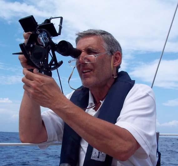
72 Observer s Horizon Zenith of Observer Altitude (H) Towards celestial body Geographical Position of celestial body For any observer on the earth, the celestial body will appear at a certain angle from the zenith (ZD) The body will also appear at an angular altitude (H) above the horizon (ZD = 90 o H) We measure H with a sextant
73 The Navigational Triangle AP : Assumed Position GP : Geographical Position of Celestial Body
74 The Navigational Triangle AP : Assumed Position (Lat, Lon) GP : Geographical Position of Celestial Body (Dec, GHA) Assumed Position comes from our Estimated Position Geographical Position comes from the Nautical Almanac
 x Cos(LHA) Cos(Z) = (Sin(Dec) Sin(Lat) x Sin(Hc)) / (Cos(Lat) x Cos(Hc)) In Northern Latitudes: In Southern Latitudes: Zn = Z when LHA > 180 o Zn = 360 o Z when LHA < 180 o Zn = 180 o Z")
75 The Navigational Triangle Knowns: Declination of body (Dec) Local Hour Angle of body (LHA) Assumed Latitude (Lat) From Law of Cosines for Spherical Geometry* Sin (Hc) = Sin(Dec) x Sin(Lat) + Cos(Dec) x Cos(Lat) x Cos(LHA) Cos(Z) = (Sin(Dec) Sin(Lat) x Sin(Hc)) / (Cos(Lat) x Cos(Hc)) In Northern Latitudes: In Southern Latitudes: Zn = Z when LHA > 180 o Zn = 360 o Z when LHA < 180 o Zn = 180 o Z when LHA > 180 o Zn = 180 o + Z when LHA < 180 o Given Dec, LHA, and Lat, one can solve for Hc and Zn *Note: Southern declinations and latitudes have negative sign in these equations
76 Observer s Horizon Zenith of Observer Altitude (H) Towards celestial body Geographical Position of celestial body We know the Computed Altitude of the body at our Assumed Position (Hc) (This is the altitude the body would have if we were at our Assumed Position) We know the azimuth from our Assumed Position to the GP of the body (Zn) We measure the Altitude of the body with our sextant and compare it with Hc We draw a line of position, perpendicular to Zn
77 True North. Assumed Position Zn Towards celestial body If our Observed Altitude (Ho) is less than Hc, then the LOP is plotted away from the celestial body by an amount equal to Hc Ho (minute of arc = nautical mile) If our Observed Altitude (Ho) is greater than Hc, then the LOP is plotted toward the celestial body by an amount equal to Ho Hc (minute of arc = nautical mile)
78 Summary Procedure Make an observation with the sextant and note the time, Hs, and the body name Convert Hs to Ho (corrections for refraction, sextant error, etc.) Get the GHA and Declination of the body from the Nautical Almanac for the time of the observation Compute the LHA of the body based on your Assumed Longitude Enter the the Sight Reduction Tables with LHA, Dec, and Assumed Latitude and get Hc and Zn Compare Hc to Ho and plot the Line of Position perpendicular to Zn
79 So Why is Celestial So Hard? You need to make a very accurate sextant measurement from a moving platform You need to make corrections to the sextant measurement Sextant index error, refraction, height of eye, parallax, diameter of body Requires table look-ups and arithmetic Several opportunities for error You need to get data from Nautical Almanac Requires several table look-ups and more arithmetic More opportunities for error You need to reduce the sights to find Zn and Hc Requires choosing a proper assumed position to use the tables More look-ups and arithmetic You need to correctly plot the LOPs
80 So Why is Celestial So Hard? You need to make a very accurate sextant measurement from a moving platform You need to make corrections to the sextant measurement Sextant index error, refraction, height of eye, parallax, diameter of body Requires table look-ups and arithmetic Several opportunities for error You need to get data from Nautical Almanac Requires several table look-ups and more arithmetic More opportunities for error You need to reduce the sights to find Zn and Hc Requires choosing a proper assumed position to use the tables More look-ups and arithmetic You need to correctly plot the LOPs Sextant: an entertaining, albeit expensive, device, which, together with a good atlas, is of use in introducing the boatman to many interesting areas on the earth's surface which he and his craft are not within 1,000 nautical miles of. - Beard and McKie
81 I looked in the Nautical Almanac and found that on that very day, June 7, the sun was behind time 1 minute and 26 seconds, and that it was catching up at a rate of 14/67 seconds per hour. The chronometer said that at the precise moment of taking the sun's altitude it was 25 minutes after 8:00 in Greenwich. From this date it would seem a schoolboy's task to correct the Equation of Time. Unfortunately I was not a schoolboy. Jack London, The Cruise of the Snark
82
MITNA January Matthew Wall Scott Dynes Steve Bussolari. Wednesday, 21 January 2015
 Navigation for Offshore Sailing MITNA January 2015 Matthew Wall Scott Dynes Steve Bussolari This new ship here, is fitted according to the reported increase of knowledge among mankind. Namely, she is cumbered,
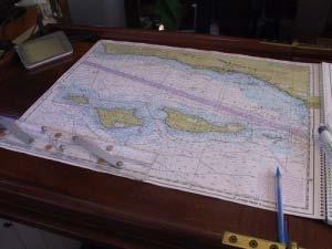
Chartwork Learn the basics for position fixing using a number of techniques and a simple equation for speed, distance and time.
 Chartwork Learn the basics for position fixing using a number of techniques and a simple equation for speed, distance and time. Chartwork Chartwork Tools Accurate chart work is the basis for good navigation.
OPERATIONS SEAFARER CERTIFICATION GUIDANCE NOTE SA MARITIME QUALIFICATIONS CODE. Deck: Chart Work
 Page 1 of 6 Compiled by Approved by Chief Examiner Syllabus Committee: 26 February 2013 OPERATIONS SEAFARER CERTIFICATION GUIDANCE NOTE SA MARITIME QUALIFICATIONS CODE Deck: Chart Work Page 2 of 6 COLUMN
Lat. & Long. Review. Angular distance N or S of equator Equator = 0º Must indicate N or S North pole = 90º N
 Navigation Part 2 1 Lesson Objectives Understand how a ships compass works and how it is used for navigation Measure distances on nautical charts Plot a course on a nautical chart Correct course headings
Navigation & Orienteering: Pre- Test
 Name: Class: Answer Key Date: Page 1 of 7 Navigation & Orienteering: Pre- Test There are three sections: Multiple Choice, True/False, and Short Answer. For the multiple choice, please select the BEST answer
28 Navigation Reminders Coastal Navigation by John C. Kelly, 2003
 28 Navigation Reminders Coastal Navigation by John C. Kelly, 2003 CRITICAL REMINDERS 1. Measure distance from latitude scales. 2. Take all bearings in degrees magnetic. 3. Always verify depth: surface
Basic Chartwork. Necessary Tools. Navigation is the one science in which no margin whatever is left for the faker. - Felix Riesenberg
 Page 1 of 14 www.bananawind.us Navigation is the one science in which no margin whatever is left for the faker. - Felix Riesenberg Basic Chartwork You wouldn't want to attempt open ocean sailing using
NAVAL RESERVE OFFICERS TRAINING CORPS NAVIGATION I LESSON GUIDE: 1 HOURS: 1
 NAVAL RESERVE OFFICERS TRAINING CORPS NAVIGATION I LESSON GUIDE: 1 HOURS: 1 TITLE: Introduction/Piloting Team I. Learning Objectives A. The student will know the professional core competency objectives
Nautical Navigation: Final Quiz
 Name: Nautical Navigation Final Quiz Class: (ver. 03/09/15) Date: Page 1 of 9 Nautical Navigation: Final Quiz There are three sections: Multiple Choice, True/False, and Short Answer. For the multiple choice,
National Maritime Center
 National Maritime Center Providing Credentials to Mariners U.S.C.G. Merchant Marine Exam (Sample Examination) Page 1 of 6 Choose the best answer to the following Multiple Choice Questions. 1. The following
 ON SHIPS OF 200 GRT/500 GT OR MORE Assessment Sheets Enclosure (1) to CG-543 Policy Letter 11-07 ASSESSMENT NO. OICNW-1-1A COMPETENCE: Plan and conduct a passage and determine position KNOWLEDGE, UNDERSTANDING
National Maritime Center
 National Maritime Center Providing Credentials to Mariners (Sample Examination) Page 1 of 17 Choose the best answer to the following Multiple Choice questions. 1. Your vessel is steering 263 T at 22 knots.
AUS small scale charts for coastal navigation. Scale: 1 to 150,000
 CHART-WORK SCALE Charts are available in different scales depending on their use. For passage planning you would use small scale charts and for close quarter manoeuvring you would use larger scale charts
National Maritime Center
 National Maritime Center Providing Credentials to Mariners Q212 Navigation General-Oceans (Sample Examination) Page 1 of 20 Choose the best answer to the following Multiple Choice questions. 1. A chart
National Maritime Center
 National Maritime Center Providing Credentials to Mariners Able Seaman Unlimited, Limited, Special, Special OSV, Sail, Fishing Industry (Sample Examination) Page 1 of 17 Choose the best answer to the following
National Maritime Center
 National Maritime Center Providing Credentials to Mariners (Sample Examination) Page 1 of 16 Choose the best answer to the following Multiple Choice Questions. 1. On U.S. charts, you can tell if a named
COXSWAIN NAVIGATION EXERCISES AUS197 NAME:
 COXSWAIN NAVIGATION EXERCISES AUS197 NAME: A deviation card is supplied at the end of this file. Check the answers Question 1 Using any chart (or use the AUS 197 extract) to: 1. Identify a distance of
National Maritime Center
 National Maritime Center Providing Credentials to Mariners (Sample Examination) Page 1 of 13 Choose the best answer to the following Multiple Choice Questions. 1. What is the approximate geographic range
Competency framework for Skipper Coastal / Offshore. Competency framework for Skipper Coastal/ Offshore
 Competency framework for Skipper Coastal/ Offshore Table of Contents... 1... 1 Function: Safety at the management level... 11 Manage safety aboard a coastal and vessel... 11 Competency framework for Skipper
National Maritime Center
 National Maritime Center Providing Credentials to Mariners (Sample Examination) Page 1 of 17 Choose the best answer to the following Multiple Choice questions. 1. Which is TRUE concerning privately maintained
Terrestrial Observations Chart Plot - Chesapeake Bay Entrance - Operational Level
 USCG 00326-NP-5 The following questions are based on chart 12221TR, Chesapeake Bay Entrance, and the supporting publications. The draft of your tow is 27 feet (8.2 meters). Use 10 W variation where required.
Pilotage. Planning for pilotage
 Pilotage Planning for pilotage Being one step ahead of the game is key to effective pilotage. Only then will you know what to expect and what s lurking around the next bend. It s useful to construct a
SAMPLE COASTAL SKIPPER CHARTWORK QUESTIONS Updated 17 October 2008
 SAMPLE COASTAL SKIPPER CHARTWORK QUESTIONS Updated 17 October 2008 Unless otherwise specified, all chartwork questions relate to chart SAN 3002. Some questions may ask you to use deviation card No1 for
UNIT FOUR NAVIGATION TEXTS, TASKS AND PROJECT
 UNIT FOUR TEXTS, TASKS AND PROJECT NAVIGATION - Navigation - Anchoring, Berthing, Leaving berth and Underway - Buoyage - Loading, Discharging & Trim - Project: Pilot Reading Glossary and Practice Navigation
Chart Features Maritime maps and Admiralty charts have these features:
 Introduction to Charts A chart or map of the area is an important safety item to carry on board. It allows the Master to obtain knowledge of the area to be travelled, and indicates the navigable channels
2005 ABC. Chapter 3 Part 2. Navigating with ATON's. Revision to D-13 Local Notes. Instructor Notes for Mike Brough. Mike Brough
 2005 ABC Chapter 3 Part 2 Navigating with ATON's Revision to D-13 Local Notes Instructor Notes for Mike Brough Mike Brough June 24 2008 June 24 2008 Slide 1 June 24 2008 New graphics Navigating on Water
Sail Canada Uniform Navigation Symbols and Terms
 Uniform Navigation Symbols and Terms This publication provides definitions, shows symbols and gives examples of the symbols and labels to be used on paper marine charts when planning and executing voyages.
Chapter IV - Sample Chart #1 Answers to Sample Chart #1
 Chapter IV - Sample Chart #1 Answers to Sample Chart #1 1. 29 10' N 2. 29 04' N 3. 28 57' N 4. 28 46' N 5. 28 38' N 6. 28 25' N 7. 28 17' N 8. 28 08' N 9. 27 51' N 10. 27 46' N Chapter IV - Sample Chart
Letter Latitude Longitude A B C D E F G
 Co-ordinates Problem Using your dividers and the chartlet on the following page complete this table. Letter Latitude Longitude A B C D E F G Nautical Charts Review. Questions 1. A Mercator projection
National Maritime Center
 National Maritime Center Providing Credentials to Mariners (Sample Examination) Page 1 of 5 Choose the best answer to the following Multiple Choice Questions. 1. The following questions are based on Chart
National Maritime Center
 National Maritime Center Providing Credentials to Mariners (Sample Examination) Page 1 of 19 Choose the best answer to the following Multiple Choice questions. 1. You are entering an African port and see
National Maritime Center
 National Maritime Center Providing Credentials to Mariners Q163 Navigation Problems-Chart 13205 TR (Sample Examination) Page 1 of 5 Choose the best answer to the following Multiple Choice Questions. Each
Stars and Compass Trophy and Novice Paper 2014!
 Stars and Compass Trophy and Novice Paper 2014 The Stars and Compass Trophy was established to promote the use and development of traditional navigation skills. This year, in a bid to encourage novice
National Maritime Center
 National Maritime Center Providing Credentials to Mariners (Sample Examination) Page 1 of 17 Choose the best answer to the following Multiple Choice questions. 1. The Coast Guard Captain of the Port has
IALA Buoyage System and Visual Aids to Navigation. by Aleksandr D. Pipchenko
 IALA Buoyage System and Visual Aids to Navigation by Aleksandr D. Pipchenko IALA buoyage regions chart Which types of marks are provided by the system? Six types of marks provided by the system: Lateral
Navigation Exercises for Practice Underway
 Workforms and Plotting Sheets for use with Navigation Exercises for Practice Underway www.starpath.com/kindle David Burch STARPATH Seattle, WA Copyright 2009, 2012 David Burch All rights reserved. No part
CHAPTER 8 PILOTING DEFINITION AND PURPOSE
 CHAPTER 8 PILOTING DEFINITION AND PURPOSE 800. Introduction Piloting involves navigating a vessel in restricted waters and fixing its position as precisely as possible at frequent intervals. More so than
 Page 1 of 6 Nav-Aid Basics Unlike the roads and highways that we drive on, the waterways we go boating on do not have road signs that tell us our location, the route or distance to a destination, or of
ELEMENTARY NAVIGATION
 ELEMENTARY NAVIGATION Chart Aus191 WGS84 MARINE RESCUE NEW SOUTH WALES Elementary navigation Registered Training Organisation Version 2.0 Acknowledgements This Elementary navigation Learner s Manual was
WORKBOOK NAVIGATION Tr. For Power-driven and Sailing Vessels DAVID BURCH LARRY BRANDT
 Piloting Dead reckoning Special publications Lights and buoys Electronic fixes Chart reading and plotting Compass use Navigation Rules Tides and currents Depth sounding navigation STARPATH This book provides
RECORD OF ASSESSMENT
 RECORD OF ASSESSMENT This record booklet can be used to document your completion of the proficiency assessments for Officer in Charge of the Navigational Watch (OICNW) in order to meet U.S. Coast Guard
Anchoring Is Important
 BCC Sailing Classes - Third Theory Anchoring Anchoring Is Important 1 The Anchor is your last resort. Anchoring Keep off a lee shore. Needs to be shaped (type of anchor) to bury in the type of bottom for
CERTIFICATES OF COMPETENCY IN THE MERCHANT NAVY DECK OFFICER STCW 95 OFFICER IN CHARGE OF NAVIGATIONAL WATCH REG. II/1 (UNLIMITED)
") CERTIFICATES OF COMPETENCY IN THE MERCHANT NAVY DECK OFFICER EXAMINATIONS ADMINISTERED BY THE SCOTTISH QUALIFICATIONS AUTHORITY ON BEHALF OF THE MARITIME AND COASTGUARD AGENCY STCW 95 OFFICER IN CHARGE
CERTIFICATES OF COMPETENCY IN THE MERCHANT NAVY DECK OFFICER EXAMINATIONS ADMINISTERED BY THE SCOTTISH QUALIFICATIONS AUTHORITY ON BEHALF OF THE MARITIME AND COASTGUARD AGENCY STCW 95 OFFICER IN CHARGE
National Maritime Center
 National Maritime Center Providing Credentials to Mariners (Sample Examination) Page 1 of 17 Choose the best answer to the following Multiple Choice questions. 1. The Coast Guard Captain of the Port has
Please contact our Education Officer if you are interested in any of these courses.
 Please contact our Education Officer if you are interested in any of these courses. Lt/Cdr Jack McKinnon, AP 770-365-9576 or Jakmck@frontier.com Elective Courses Six Elective Courses are offered by USPS.
CHAPTER 8 PILOTING DEFINITION AND PURPOSE
 CHAPTER 8 PILOTING DEFINITION AND PURPOSE 800. Introduction Piloting involves navigating a vessel through restricted waters. As in all other phases of navigation, proper preparation and strict attention
National Maritime Center
 National Maritime Center Providing Credentials to Mariners Q203 Navigation General-Near Coastal (Sample Examination) Page 1 of 20 Choose the best answer to the following Multiple Choice questions. 1. How
Navigation with Leeway
 Navigation with Leeway Leeway, as we shall use the term, means how much a vessel is pushed downwind of its intended course when navigating in the presence of wind. To varying extents, knowledge of this
Sailing Blind: The Challenges of a Submarine's Navigator
 Sailing Blind: The Challenges of a Submarine's Navigator John Clark, Physics Teacher and Military Historian, Deltona HS, Deltona 2012 Naval Historical Foundation STEM-H Teacher Fellowship Instructional
COMDTCHANGENOTE NVIC February 21, 2017
 Commandant United States Coast Guard US Coast Guard Stop 7509 2703 Martin Luther King Jr Ave SE Washington, DC 20593-7509 Staff Symbol: CG-MMC-2 Phone: 202-372-2357 Fax: 202-372-1246 Email: MMCPolicy@uscg.mil
Section D 4: Introduction to plotting
 Boating Course Student s Notes Section 4 Section 4: Introduction to plotting 4.1 General If a boat is being conned through a winding channel where there is a great deal of boat traffic, the helmsman is
Supplement to. Navigation Workbook for Practice Underway.
 Supplement to Navigation Workbook for Practice Underway. This file contains duplicate printable workrooms, plotting sheets, and logbook pages to use with the workbook as needed. They are the blank forms
UNITED STATES COAST GUARD AUXILIARY NAVIGATION SPECIALTY COURSE AUXNAV. Student Text and Study Guide
 UNITED STATES COAST GUARD AUXILIARY NAVIGATION SPECIALTY COURSE AUXNAV Student Text and Study Guide FOREWORD: The USCG Auxiliary Navigation Specialty Course is divided into two distinct and separate, yet
SKIPPER CATEGORY B (UP TO 24 NAUTICAL MILES FROM THE SHORE) SYLLABUS
 SYLLABUS") SKIPPER CATEGORY B (UP TO 24 NAUTICAL MILES FROM THE SHORE) SYLLABUS SUBJECTS/TOPICS TOTAL HOURS FOR EACH SUBJECT AREA 1. Candidates may be questioned on Code de la Mer 06 Covered for Skipper 12 Nautical
SKIPPER CATEGORY B (UP TO 24 NAUTICAL MILES FROM THE SHORE) SYLLABUS SUBJECTS/TOPICS TOTAL HOURS FOR EACH SUBJECT AREA 1. Candidates may be questioned on Code de la Mer 06 Covered for Skipper 12 Nautical
What is navigation? Diederik Willemsen
 Navigation course www.sailingissues.com This is an advanced online course on marine navigation, providing you with the conditio sine qua non of offshore sailing. Nowadays most sailors tend to rely on modern
NAVIGATION AND VESSEL INSPECTION CIRCULAR NO , CH-2
 Commandant United States Coast Guard US Coast Guard Stop 7509 2703 Martin Luther King Jr. Ave. SE Washington, DC 20593-7509 Staff Symbol: CG-MMC Phone: (202) 372-2357 Fax: (202) 372-1246 E-Mail: MMCPolicy@uscg.mil
NAVIGATION AND VESSEL INSPECTION CIRCULAR NO
 Commandant United States Coast Guard US Coast Guard Stop 7509 2703 Martin Luther King Jr. Ave. SE Washington, DC 20593-7509 Staff Symbol: CG-MMC Phone: (202) 372-2357 Fax: (202) 372-1246 E-Mail: MMCPolicy@uscg.mil
iii) Satisfactory completion of approved training in the following:
 Satisfactory completion of approved training in the following:") Enclosure (1) to NVIC 13-14 DISCUSSION OF QUALIFICATION REQUIREMENTS FOR MASTER AND OFFICER IN CHARGE OF A NAVIGATIONAL WATCH ON VESSELS OF LESS THAN 500 GT LIMITED TO NEAR-COASTAL WATERS 1. GENERAL. This
Enclosure (1) to NVIC 13-14 DISCUSSION OF QUALIFICATION REQUIREMENTS FOR MASTER AND OFFICER IN CHARGE OF A NAVIGATIONAL WATCH ON VESSELS OF LESS THAN 500 GT LIMITED TO NEAR-COASTAL WATERS 1. GENERAL. This
The objects lie in a straight line. Plotting radio bearings over a long distance. expose any loose connections. hs to the visible horizon
 BK NUM ANS QUESTION ANSWER A ANSWER B ANSWER C ANSWER D ILLUST 3 458 A The prevailing westerlies of the Southern Hemisphere blow 18-30 knots all year long during the summer months only during the winter
National Maritime Center
 National Maritime Center Providing Credentials to Mariners Q412 Navigation General-Near Coastal (Sample Examination) Page 1 of 14 Choose the best answer to the following Multiple Choice Questions. 1. Which
2 Boating Rules and Regulations... 73
 Contents at a Glance Chapter 1 Boat Design and Construction Chapter 2 Boating Rules and Regulations Chapter 3 Navigation Rules (ColRegs) Chapter 4 Boat Operating and Seamanship Chapter 5 Piloting and Navigation
 Master
 National Maritime Center
 National Maritime Center Providing Credentials to Mariners (Sample Examination) Page 1 of 5 Choose the best answer to the following Multiple Choice Questions. 1. (The following questions are based on Chart
Bermuda to Portland, ME
 Newport to Bermuda September 21-28, 2014 Bermuda to Portland, ME September 28 - October 5, 2014 Phillip Plisson Come experience the ultimate offshore sailing adventure Captain Richard Bailey, former captain
Southern Region, B.S.A. Yachting Initiative Program Elements PILOTING ESSENTIALS. Learning Objectives:
 PILOTING ESSENTIALS Learning Objectives: As a result of this session the participant should: Be familiar with the characteristics of a Nautical Chart. Be aware of the functionality of the Magnetic Compass.
National Maritime Center
 National Maritime Center Providing Credentials to Mariners (Sample Examination) Page 1 of 12 Choose the best answer to the following Multiple Choice Questions. 1. An alternating light. (A) shows a light
National Maritime Center
 National Maritime Center Providing Credentials to Mariners Q113 Navigation General-Near Coastal (Sample Examination) Page 1 of 18 Choose the best answer to the following Multiple Choice questions. 1. Your
Intermediate Cruising Standard (ASA 104)
") Intermediate Cruising Standard (ASA 104) Prerequisites: Basic Keelboat Sailing (ASA 101) and Basic Coastal Cruising (103) Certification General Description: Demonstrated ability to skipper a sloop-rigged,
Intermediate Cruising Standard (ASA 104) Prerequisites: Basic Keelboat Sailing (ASA 101) and Basic Coastal Cruising (103) Certification General Description: Demonstrated ability to skipper a sloop-rigged,
properly applied assessment in the use.1 landmarks.1 approved in-service of ECDIS is not experience The primary method of fixing required for those
 STCW Code Table A-II/3 Specification of minimum standard of for officers in charge of a navigational watch and for masters on ships of less than 500 gross tonnage engaged on near-coastal voyages Ref: https://www.edumaritime.net/stcw-code
THE CITY UNIVERSITY OF NEW YORK KINGSBOROUGH COMMUNITY COLLEGE OFFICE OF MARITIME TECHNOLOGY MT-30 INTRODUCTION TO MARITIME TECHNOLOGY I
 THE CITY UNIVERSITY OF NEW YORK KINGSBOROUGH COMMUNITY COLLEGE OFFICE OF MARITIME TECHNOLOGY MT-30 INTRODUCTION TO MARITIME TECHNOLOGY I Anthony D. DiLernia Maritime Technology Office: T-301C Telephone:
Search Techniques. Contents
 Search Techniques Contents Overview... 2 1. Developing the Search Plan... 2 1.1 Search Planning Sequence... 2 2. Search Terminology... 3 3. Search Patterns... 6 4. Searching and GPS... 8 5. Search Protocols...
AIR NAVIGATION. Key Revision. Press F5 to start.
 AIR NAVIGATION Key Revision Press F5 to start. This presentation may be used either as a revision aid or as a self-test program. Revision Self-test Instructions This presentation may be used either as
Race Management Policies for World Sailing Events Fleet Racing Updated for Oceania & Australian Laser Regattas
 Race Management Policies for World Sailing Events Fleet Racing Updated for Oceania & Australian Laser Regattas 31 Dec 2018 Principles in the revision Make the statements more the order in which they occur
For the love of the Vineyard and the sea Think Sail MV
 Youth Summer sailing syllabus For the love of the Vineyard and the sea Think Sail MV Racing Seamanship Gold Vondée Silver Volvo Bronze Sail Martha s Vineyard Youth sailing syllabus Clipper Swordfish Mackerel
ADMINISTRATIVE INSTRUCTION No. STCW-14 QUALIFICATION / CERTIFICATION REQUIRED FOR OPERATION OF A DOMESTIC VESSESL
 ADMINISTRATIVE INSTRUCTION No. STCW-14 QUALIFICATION / CERTIFICATION REQUIRED FOR OPERATION OF A DOMESTIC VESSESL (Issued under section 3(5) of the Gibraltar Merchant Shipping (Safety etc.) Ordinance 1993
Race Management Policies for SB20 World Championship 2018
 Race Management Policies for SB20 World Championship 2018 Based on Race Management Policies for World Sailing Events Fleet Racing 3 October 2017 Race Management Policies for SB20 World Championship 2018
Nautical Chart Challenge
 Discover Your World With NOAA Nautical Chart Challenge For as long as anyone in his family could remember, Francis Beaufort wanted to make scientific observations from the deck of a ship. In 1789 at the
REGION B ONLY. Figure Figure Figure Figure Figure Figure Figure Figure 10.60
 221 REGION B ONLY 10.5 LATERAL MARKS 10.5.1 Description of Lateral marks Port hand marks Shape: pillar buoy (Figures 10.53 and 10.54), can lighted buoy (Figures 10.55 and 10.56) or not lighted (Figures
Lesson 2: Sailing. A league is three nautical miles. (A nautical mile is about 800 feet longer than a mile on land.)
") Early Explorers -> 2: Sailing Lesson 2: Sailing Getting Started? Big Ideas What methods did sailors have for survival on the seas? & Facts and Definitions 8 Skills " Materials Introduction Navigation is
Early Explorers -> 2: Sailing Lesson 2: Sailing Getting Started? Big Ideas What methods did sailors have for survival on the seas? & Facts and Definitions 8 Skills " Materials Introduction Navigation is
National Maritime Center
 National Maritime Center Providing Credentials to Mariners (Sample Examination) Page 1 of 8 Choose the best answer to the following Multiple Choice questions. 1. On 1 September your 1115 zone time DR position
Gorgon - Pilotage - Passage Plan - PBG to Gorgon Marine Terminal - Alternative Route
 1.0 Introduction This work instruction outlines the passage plan to be used by vessels transiting from the Port of Barrow Island PBG to the Gorgon Marine Terminal, via the alternative route, with a Pilot
Rules Practice Exam 14
 1 BOTH INTERNATIONAL & INLAND Additional light signals are provided in the Annexes to the Rules for vessels. A. engaged in fishing B. not under command C. engaged in towing D. under sail 2 BOTH INTERNATIONAL
in the centre of the celestial sphere between the plane of true meridian and the direction to the celestial body
 FUNCTON NAVIGATION LEVEL OPERATIONAL NO CODE QUESTION ANSWER_ ANSWER_ ANSWER_ ANSWER_ CORREC T_ANSW ER 1 Altitude of the celestial body is the angle in the centre of the celestial sphere between the plane
Gorgon - Pilotage - Passage Plan Materials Offloading Facility (MOF) to PBG
 to PBG") Gorgon - Pilotage - Passage Plan Materials Offloading Facility (MOF) to PBG 1.0 Introduction Vessels transiting within port limits from the Materials Offloading Facility (MOF) to the Barrow Island Pilot
Gorgon - Pilotage - Passage Plan Materials Offloading Facility (MOF) to PBG 1.0 Introduction Vessels transiting within port limits from the Materials Offloading Facility (MOF) to the Barrow Island Pilot
INLAND WATERS SYLLABUS
 INLAND WATERS SYLLABUS As at 14 May 2012 Index Page 1. Nautical Terms 2 2. Knots and Ropework 3 3. Charts and Navigational Publications 3 4. Navigation 3 5. GPS 4 6. Other Navigational Instruments 4 7.
Navigating Barker Inlet: some exercises
 Introduction The Torrens Island and nvirons map A few things have changed since the Torrens Island and nvirons (TI) map was published. The most obvious from Barker Inlet is the new silo and bulk grain
Incident Report. Close Quarters Pegasus II & Distraction. 26 April 2006 Class B
 Incident Report Close Quarters Pegasus II & Distraction 26 April 2006 Class B NARRATIVE Pegasus II (See Photograph 1 Pegasus II) is a 15.46 metre commercial fishing vessel with a gross tonnage of 40. She
International Civil Aviation Organization
 International Civil Aviation Organization WORKING PAPER 11 August 2015 ENGLISH ONLY Agenda item 4 ICAO/IMO JOINT WORKING GROUP ON HARMONIZATION OF AERONAUTICAL AND MARITIME SEARCH AND RESCUE (ICAO/IMO
METHODS EMPLOYED IN LOCATING SOUNDINGS
 METHODS EMPLOYED IN LOCATING SOUNDINGS The soundings are located with reference to the shore traverse by observations made (i) entirely from the boat, (ii) entirely from the shore or (iii) from both. The
Kayak Navigation for Normal People Tim Mattson,
 Kayak Navigation for Normal People Tim Mattson, timothy.g.mattson@intel.com Deception pass chart provided by Don Beale Photo by Jodi Wright The Essence of Kayak Navigation A kayaker at ANY point should
Compass and chart fundamentals and basic piloting techniques Instructor Manual
 CHART SMART Compass and chart fundamentals and basic piloting techniques Instructor Manual CHART SMART Compass and chart fundamentals and basic piloting techniques This Learning Guide is one of a group
RACE MANAGEMENT POLICY GUIDELINES FOR THE FINN CLASS MAJOR CHAMPIONSHIPS 2018.
 RACE MANAGEMENT POLICY GUIDELINES FOR THE FINN CLASS MAJOR CHAMPIONSHIPS 2018. Please note that these policies are guidelines to the Race Management Team. Failure to observe these guidelines are not grounds
CREW BOOKLET. The Sea School P/L. (Sea School Certificate Level 1) Contents:
 Contents:") The Sea School P/L www.bluepeteraustralia.com ACN: 168709251 CREW BOOKLET (Sea School Certificate Level 1) Contents: Hopes and Concerns Crew Roles Program Outline Weather Tides Waves Minimal Impact Navigation
The Sea School P/L www.bluepeteraustralia.com ACN: 168709251 CREW BOOKLET (Sea School Certificate Level 1) Contents: Hopes and Concerns Crew Roles Program Outline Weather Tides Waves Minimal Impact Navigation
Gorgon - Pilotage - Passage Plan PBG to Materials Offloading Facility (MOF)
") 1.0 Introduction Vessels transiting within port limits from the Barrow Island Pilot Boarding Ground (PBG) to the require an approved passage plan which can be shared between Pilots and vessel Masters.
1.0 Introduction Vessels transiting within port limits from the Barrow Island Pilot Boarding Ground (PBG) to the require an approved passage plan which can be shared between Pilots and vessel Masters.
CHAPTER 9 NAVIGATIONAL DUTIES
 CHAPTER 9 NAVIGATIONAL DUTIES Navigation is the art or science of determining the position of a ship or aircraft and directing that ship or aircraft from one position to another. It can be regarded as
BOAT CREW HANDBOOK Navigation and Piloting
 BOAT CREW HANDBOOK Navigation and Piloting Captain John A. Henriques BCH 16114.3 December 2017 John Ashcroft Henriques John Ashcroft Henriques was one of the most important Revenue Cutter Service officers
LANGLEY SQUADRON MID-TERM KNOWLEDGE CHECK
 LANGLEY SQUADRON MID-TERM KNOWLEDGE CHECK Seamanship 1. (d) only (a) and (c) 2. (d) all of the above 3. (a) chocks 4. (a) placed at the end of the cord and the tool plugged directly in (a) Inboard Direct
CALCULATING IN-FLIGHT WINDS
 CALCULATING IN-FLIGHT WINDS SITUATION: The TH of your aircraft is 350 with the TAS of 150 kts. GS has been determined to be 160 kts, and the Track is 355. What is the wind? ESTIMATE! First compare TAS
STUDENT STUDY GUIDE ASA 104 INTERMEDIATE COASTAL CRUISING & BAREBOAT CHARTERING
 STUDENT STUDY GUIDE ASA 104 INTERMEDIATE COASTAL CRUISING & BAREBOAT CHARTERING Page 1 Intermediate Cruising Standard (ASA 104) Prerequisites: Basic Keelboat Sailing (ASA 101) and Basic Coastal Cruising
One of the most important gauges on the panel is
 stick & rudder flight advisor Is Your Airspeed Indicator Honest? An accuracy how-to H.C. SKIP SMITH One of the most important gauges on the panel is the airspeed indicator. This is particularly true if