Surface circulation in the Liguro-Provençal basin as measured by. satellite-tracked drifters ( )
|
|
|
- Ronald Hicks
- 6 years ago
- Views:
Transcription
1 Surface circulation in the Liguro-Provençal basin as measured by satellite-tracked drifters ( ) Pierre-Marie Poulain 1, Riccardo Gerin 1, Michel Rixen 2, Pietro Zanasca 2, Joao Teixeira 2,3, Annalisa Griffa 4,5, Maurizio De Marte 6 and Nadia Pinardi 7 1 Istituto Nazionale di Oceanografia e di Geofisica Sperimentale, OGS, Trieste, Italy 2 NATO Undersea Research Centre, La Spezia, Italy 3 California Institute of Technology, Pasadena, California, USA 4 Consiglio Nazionale delle Ricerche, CNR-ISMAR, La Spezia, Italy 5 University of Miami, Miami, Florida, USA 6 Istituto Idrografico della Marina, Genova, Italy 7 University of Bologna, Ravenna, Italy Corresponding Author: Pierre-Marie Poulain Istituto Nazionale di Oceanografia e di Geofisica Sperimentale (OGS) Borgo Grotta Gigante, 42/c Sgonico (Trieste), Italy Phone: Fax: ppoulain@inogs.it Submitted to the Journal of Marine Systems January
2 Abstract The surface circulation in the Liguro-Provençal basin (Northwestern Mediterranean) is studied using satellite-tracked drifters in Complex circulation patterns prevailed in the eastern Ligurian Sea, before the drifters eventually joined the Northern Current (NC) in the coastal area off Genoa. Between 5 E and 7 E30, most drifters were advected offshore before heading to the east and eventually closing a basin-wide cyclonic circulation. This offshore turning is related to the wind and wind stress curl during Mistral events. Although the Western Corsican Current was well delineated by the drifters, no signature of the Eastern Corsican Current was shown, indicating limited connectivity between the Tyrrhenian and Ligurian seas in summer Pseudo-Eulerian velocity statistics were calculated in the coastal region extending between Genoa and the Gulf of Lyons. Fast currents are evident on the shelf break, especially off Imperia (maximum of 90 cm/s) where the bathymetric slope is larger and the NC is closer to shore and narrower. In contrast, a stagnation area inshore of the NC near Fréjus is characterized by little mean flow and low velocity fluctuations. Mean currents are also reduced off Menton-Nice where the variability is maximum. More to the west, the NC broadens and slightly reduces in strength. Keywords: Surface Circulation; Drifters; Coastal Currents; Northwestern Mediterranean 2
3 1. Introduction The Liguro-Provençal basin (LPB) is located in the northwestern Mediterranean Sea (41-45 N, 5-10E ; Fig. 1) off the coasts of Italy and France. The LPB is connected to the east to the Tyrrhenian Sea through the Corsica Channel, whereas to the west, it confines with the Gulf of Lyons. The water circulation in the LPB was studied since the 1960s using hydrographic data (profiles of temperature and salinity) and consists of a mean basin-wide cyclonic gyre (Ovchinnikov, 1966; Crépon et al., 1982) which extends over the upper 500 m layer and can spread out to the west into the Catalan Sea. These results were confirmed about 20 years later by direct current measurements (with moored currentmeters) in the Corsica Channel (Astraldi et al., 1990; Astraldi and Gasparini, 1992) and between Corsica and France (Taupier-Letage and Millot, 1986; Millot, 1987; Sammari et al., 1995). The LPB circulation is connected to the Tyrrhenian and Balearic circulations by two northward flowing currents, located on the opposite sides of the Corsica Island. The first, called by Pinardi et al. (2006) the Eastern Corsican Current (ECC), brings Tyrrhenian water into the LPB. It is driven by the steric sea level difference between the Tyrrhenian Sea and the LPB, which is maximum in winter and due to the larger heat loss sustained by the LPB during this season (Astraldi and Gasparini, 1992; Astraldi et al., 1990), as well as by the wind stress curl as shown by Pinardi and Masetti (2000). These authors showed that the Corsica transport weakens dramatically in absence of wind forcing and in particular the transport can reverse in the summer season. West of Corsica, the other northward current, called Western Corsican Current (WCC) in Pinardi et al. (2006), appears to be more constant over the year. The WCC is part of the large cyclonic LPB circulation mainly forced by the geostrophic adjustment to the dense water formation processes occurring in winter in the central LPB (MEDOC Group, 3
4 1970; Crépon and Boukthir, 1987) and the dominant wind stress curl due to the Mistral wind regime (Pinardi and Navarra, 1993, Molcard et al., 2002). The confluence of the ECC and WCC north of Corsica forms the Northern Current (NC), also called the Liguro-Provençal-Catalan Current, which flows along the Italian (west of Genoa), French and Spanish coasts (Millot, 1991). Molcard et al. (2002) showed that the WCC and ECC are part of a basin-wide circulation pattern that is wind driven and that the confluence of the WCC and ECC produces the NC as a nonlinear intensification at the northern boundary of the domain. The NC transports about 2 Sv of sea water between the coast and 33 km offshore (Béthoux et al., 1988; Sammari et al., 1995). Speeds in the NC can be as large as 1 m/s at the surface and about 5 cm/s at depth (400 m). Its core is narrow and centered at 20 km or less from the shore in spring-summer, whereas it is broader and more distant from the coast in autumn (Sammari et al., 1995). Béthoux et al. (1988) showed that the NC seasonal variability is related to the local river runoffs and to the winter deep water formation processes. Numerical simulations (Pinardi and Navarra, 1993, Herbaut et al., 1997; Pinardi and Masetti, 2000, Mounier et al., 2005) demonstrated that the overall LPB cyclonic circulation, is actually thermohaline and wind driven. The cyclonic circulation is reinforced by the wind stress curl acting over the basin. The influence of the wind forcing on the NC in the Gulf of Lyons was qualitatively established by Millot and Wald (1980) using satellite thermal imagery and explained quantitatively by the modeling results. During Mistral wind events the surface flow associated with the NC veers offshore when reaching the Gulf of Lyons, forming the western limb of the LPB cyclonic circulation. Under no or weak wind conditions, and especially during the stratification period (summer), the surface NC continues westward along the coast towards the Catalan Basin (Millot and Wald, 1980). 4
5 Mesoscale variability is ubiquitous and dominant in most parts of the LPB and in particular in the NC (Taupier-Letage and Millot, 1986, Echevin et al., 2003, Sammari et al., 1995). There are marked seasonal variations in the mesoscale activity with a maximum in winter when the NC is deeper, stronger and narrower, closer to the coast and instability processes generate mesoscale structures. The circulation in the LPB was recently investigated using satellite altimeter data (Pujol, 2006; Birol et al., 2010). Objectively interpolated and along-track sea level anomalies combined with the mean dynamic topography of Rio et al. (2007) show clearly a depression of the order of 10 cm corresponding to the basin-wide cyclonic circulation in the LPB. The western and southern limbs of this circulation are usually located in the Catalan Sea and just north of the Balearic Islands (forming the Balearic Current), respectively, in good qualitative agreement with the historical maps based on hydrographic data. Monthy-averaged surface geostrophic currents derived from the altimeter data in the NC reach 10 cm/s in winter. Collocated and contemporaneous insitu ADCP measurements are comparable with these results (Birol et al., 2010), although being a little more energetic in terms of mean current and variability. The satellite altimeter data reveal substantial interannual variability of the NC during the period Lagrangian measurements in the LPB date back to 1982 when three surface drifters where deployed in the WCC during the DYOME experiment (Taupier-Letage and Millot, 1986). Surface speeds of cm/s were measured in the WCC. Highfrequency (presumably inertial) and mesoscale motions are noticeable in all the drifter trajectories. After a complex pathway, one drifter eventually joined the NC and moved westward along the French coast. Drifter deployed in the Tyrrhenian Sea 5
6 occasionally entered into the LPB through the Corsica Channel (see Mediterranean and Tyrrhenian drifter databases at the MedSVP web site: ). In a recent work by Rinaldi et al. (2010), Tyrrhenian drifters show complex circulation patterns in the Corsica Channel. In this study, we describe the surface circulation in the LPB (and the Gulf of Lyons) using the data of Lagrangian drifters purposefully deployed in the LPB to measure the surface water general circulation and dispersion. Although the drifters were deployed at a unique site in the central Ligurian Sea in order to better describe dispersion properties, during several episodes in 2007 and 2008, they covered the whole LPB and sampled adequately the NC, thus providing an opportunity to describe for the first time the LPB surface circulation based on in-situ drifter data. After a brief description of the data and methods (section 2), a qualitative description of the LPB based on the drifter trajectories is proposed (section 3). The influence of the Mistral wind forcing is also addressed, and in particular, its role in closing the LPB surface cyclonic circulation southeast of the Gulf of Lyons. The more abundant drifter data in the NC allows a description of its surface flow based on pseudo-eulerian statistics (section 4). Discussions and conclusions are found in section Data and methods 2.1 Drifter data Since the advent of satellite tracking in the late 1970s, the use of drifters has become an effective methodology to measure marine currents and water properties over a large range of spatial and temporal scales. Despite this sampling benefit, surface drifters have the drawback that they can slip with respect to the surface waters due to the direct effect of winds and waves, and they are therefore called quasi-lagrangian 6
7 drifters. This slip was reduced and quantified for a few types of drifters such as the Surface Velocity Program (SVP) and Coastal Ocean Dynamics Experiment (CODE) designs (Pazan and Niiler, 2001; Poulain et al., 2009). CODE drifters have been commonly used in coastal regions and marginal seas, such as the Gulf of Mexico (Ohlmann et al., 2001), the Adriatic Sea (Poulain, 1991; Ursella et al., 2006) and the Gulf of La Spezia (Molcard et al., 2009; Haza et al., 2010). CODE drifters were developed by Davis (1985) in the early 1980 s to measure the currents in the first meter under the sea surface. The CODE drifters used in this study were manufactured by Technocean (model Argodrifter). They consist of a slender, vertical, 1-m-long negatively buoyant tube with four drag-producing vanes extending radially from the tube over its entire length and four small spherical surface floats attached to the upper extremities of the vanes to provide buoyancy (Poulain, 1999). Direct slip measurements (P.-M. Poulain, Personal Communication) with acoustic currentmeters showed that the Technocean CODE drifters follow the surface currents within 2 cm/s. In addition to the standard satellite Argos tracking and telemetry, the drifters were equipped with Global Positioning System (GPS) receivers. The Dopplerbased Argos tracking has an accuracy of m and positions are typically available 6-12 times per day. GPS locations have a higher accuracy (~10 m; Barbanti et al., 2005) and are sampled more frequently (every hour). All the drifter data (GPS positions, sea surface temperature, battery voltage) were transmitted to the Argos satellite system. The drifters were deployed as part of Marine Rapid Environmental Assessment (MREA) exercises in small scale clusters (~1 km) of 3-5 units at a single location in the open Ligurian Sea in the vicinity of the ODAS buoy (9 E10.2, 43 N47.4 ; see 7
8 Fig. 1). Deployments were carried out in May 2007 and June 2007 as part of the MREA-07 and LASIE-07 (Ligurian Air-Sea Interaction Experiment) experiments (Teixeira, 2007; Fabbroni, 2009). In 2008, the deployments were repeated three times during the MREA-08 sea trial. Deployment details are listed in Table 1. Some drifters stranded on the Italian and French coasts and were successfully redeployed. Taken into account that some drifters failed transmitting right after deployments and that others were recovered and redeployed, the 26 CODE drifters used provided 34 individual trajectories in total. Both Argos and GPS data were quality controlled, combined and interpolated at 2-h uniform intervals using a kriging optimal interpolation method based on a structure function whose characteristics were calculated from the data themselves (Hansen and Poulain, 1996). They were subsequently low-passed filtered with a hamming filter with cut-off period at 36 hours, in order to eliminate tidal and inertial variability, and then subsampled every 6 hours. Velocities were then calculated as finite differences of the subsampled positions. The drifters covered a relatively large area of the LPB (Fig. 1), and some units even escaped into the Tyrrhenian, Catalan and Algerian basins. Spatial coverage is maximal in the eastern Ligurian Sea north of Corsica, and in the NC between Genoa and the Gulf of Lyons. Some drifters entered the Gulf of Lyons in 2008, before continuing towards the Catalan Sea. Because of stranding and sea hazards, drifters were rather short-lived (mean half life of 20.5 days) and, as a result, the temporal distribution of the data is very intermittent (Fig. 2, top panel). Temporarily, the LPB was sampled by the drifters during 14 May - 19 October 2007 (MREA07-LASIE07) and 1 October January 2009 (MREA08). The maximum data density occurred on 23 June 8
9 2007 with 12 drifters working simultaneously. If we examine the monthly distribution of the data, independently of the year (Fig. 2, bottom panel), it appears that no (few) data are available from February to April (in January and September), and that essentially the summer and fall conditions were sampled. Restricting the dataset to the NC area between the Gulf of Genoa and the Gulf of Lyons, the daily distribution becomes even more intermittent and only the months between June and November have data. The drifter data used in this study were also used by Fabbroni (2009) to validate numerical simulations of the dispersion of surface tracers using relocatable nested models, by Vandenbulcke et al. (2009) to predict surface drifter with super-ensemble techniques and by Schroeder et al. (2010) to study relative dispersion in the LPB. 2.2 Wind products Cross-Calibrated, Multi-Platform (CCMP) ocean surface wind velocity products were downloaded from the NASA Physical Oceanography DAAC for the period of study (Atlas et al., 2009). These products were created using a variational analysis method to combine wind measurements derived from several satellite scatterometers and microwave radiometers. Six-hourly gridded analyses with 25 km resolution were used (level 3.0, first-look version 1.1). These wind products were utilized to assess the effect of the northwesterly Mistral winds prevailing in most of the northwestern Mediterranean, and in particular in the Gulf of Lyons, on the surface currents. In order to confirm that the LPB cyclonic surface circulation is short cut with a south-southeastward current in front of the Gulf of Lyons, in other words, that the surface water flowing in the NC is deviated offshore 9
10 and closes the basin-wide cyclonic loop during Mistral events, the CCMP surface winds at one location southeast of the Gulf of Lyons (41 N52.5 and 5 E52.5 ) were used. These wind data were sorted in the following categories (winds blowing from the entire northwestern sector with speeds in excess of 5 m/s, considered in this paper as Mistral; all winds with speeds less than 5 m/s or blowing from the other sectors). These wind regimes are used in the next section, along with the drifter trajectories, to qualitatively show the influence of the Mistral when drifters are reaching the vicinity of the Gulf of Lyons. The CCMP winds were also used to calculate the curl of the pseudo wind stress. Both winds and pseudo wind stresses were averaged over selected periods to produce maps with the mean wind field and the zero wind stress curl lines. 2.3 Pseudo-Eulerian statistics Pseudo-Eulerian statistics of the surface velocity were computed in the area of the NC extending between the Gulf of Genoa and the Gulf of Lyons where the data are more abundant (dashed rectangle in Fig. 1). First, the coordinate system was rotated around, and distances were computed from, a point located at 43 N30, 7 E30. The rotation is 40 anti-clockwise from the zonal direction in order to align the x-axis approximately parallel to the coast. Second, the low-pass filtered 6-hourly drifter velocities were averaged in non-overlapping bins of 5 km (y-axis or cross-shore direction) by 10 km (x-axis or along-shore direction). This anisotropy was adopted because cross-shore variations are expected to be more pronounced than those in the along-shore direction. The following quantities were computed within the bins: number of 6-hourly observations, mean flow, velocity variance ellipses, kinetic energies of the mean flow (MKE) and of the fluctuating currents (EKE). Definitions 10
11 can be found in Poulain (2001). The statistics are only considered (and plotted) for the bins with at least 3 observations. In selected coastal areas, such as the area of Imperia, Menton-Nice and Fréjus, the drifter velocities were averaged in 4 km by 30 km rectangles oriented in the alongshore direction (rotated anti-clockwise by 40 with respect to the zonal direction and with 50% overlapping in the cross-shore direction) to study the structure of the NC and its relation to bathymetry. 3. Qualitative description and wind effects The first group of drifters deployed in May 2007 (Fig. 3a) moved coherently to the SE for about 10 days and then spread apart with some units eventually approaching the Italian coast and joining the NC. Two drifters were advected offshore near longitude 7 E, veered to the southeast towards Corsica and joined the WCC. One of these proceeded northward towards the Gulf of Genoa and closed a basin-wide cyclonic loop in about 35 days. In contrast, the other unit moved eastward north of Corsica and was trapped by a strong anticyclonic eddy located in the Corsica Channel. After completing a total of five loops, four around the Capraia Island and an extended one encircling the Elba Island as well, between late July and mid August 2007, this drifter finally escaped to the south in the Tyrrhenian Sea. The period of rotation in the anticyclone is about 3 days. The drifters deployed in June 2007 (two clusters separated by 5 days, see Table 1), remained in a tight group and moved northward before reaching the Italian coastal areas and joining the NC (Fig. 3b,c). As a result, all 10 units sampled the NC. One drifter travelled in a first cyclonic loop located between 7 and 9 E (size of about
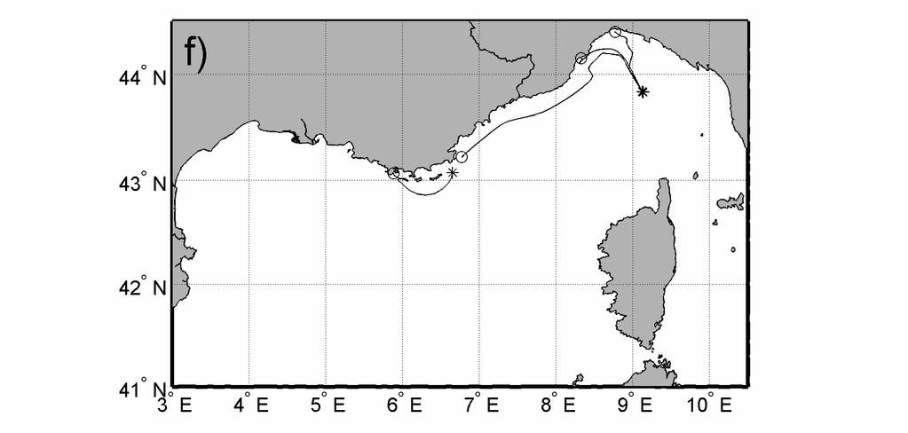
12 km and rotation period of 16 days) and then continued with the NC towards the Gulf of Lyons (Fig. 3b). There it was driven offshore again, moved to the south, and then to the east to reach the southwestern Corsican coast and joined the WCC. It continued with northward heading towards Genoa and entered the NC for the third time. This external loop in the LPB took about 2 months. A second drifter travelled approximately along the same path but stranded near the southern tip of Corsica. Another drifter re-circulated cyclonically from the NC to WCC but moved eastward north of Corsica (Fig. 3b). The drifters deployed during the second episode (on 22 June 2007), except for some units stranding on the French coast, stayed together as far as the Gulf of Lyons where they were driven offshore (Fig. 3c). One unit eventually came back with the WCC, was caught by a coastal eddy north of Corsica, and then reached the Corsica Channel in the Capraia anticyclone mentioned above. No basin-wide closed circulation was shown by the drifters released in Following the first two deployments (Fig. 3d,e), the drifters essentially moved to the northeast, turning anticyclonically into a southward current which extended into the Corsica Channel (Fig. 3d) and then almost reached the NC. Those which arrived in the vicinity of the Gulf of Lyons continued their westward motion, with some meandering and looping into the Gulf, towards the Catalan Sea. One unit was advected again offshore in front of the Gulf (near longitude 5 E, Fig. 3d) but made a U-turn near 6 E30, 41 N15, showing northwestward currents in late December 2008 and early January 2009 where all the other drifters (deployed in 2007) have shown southeastward flow. The last drifters deployed in late October 2008 moved to the northwest and one of them sampled the NC as far as the Gulf of Lyons (Fig. 3f). 12
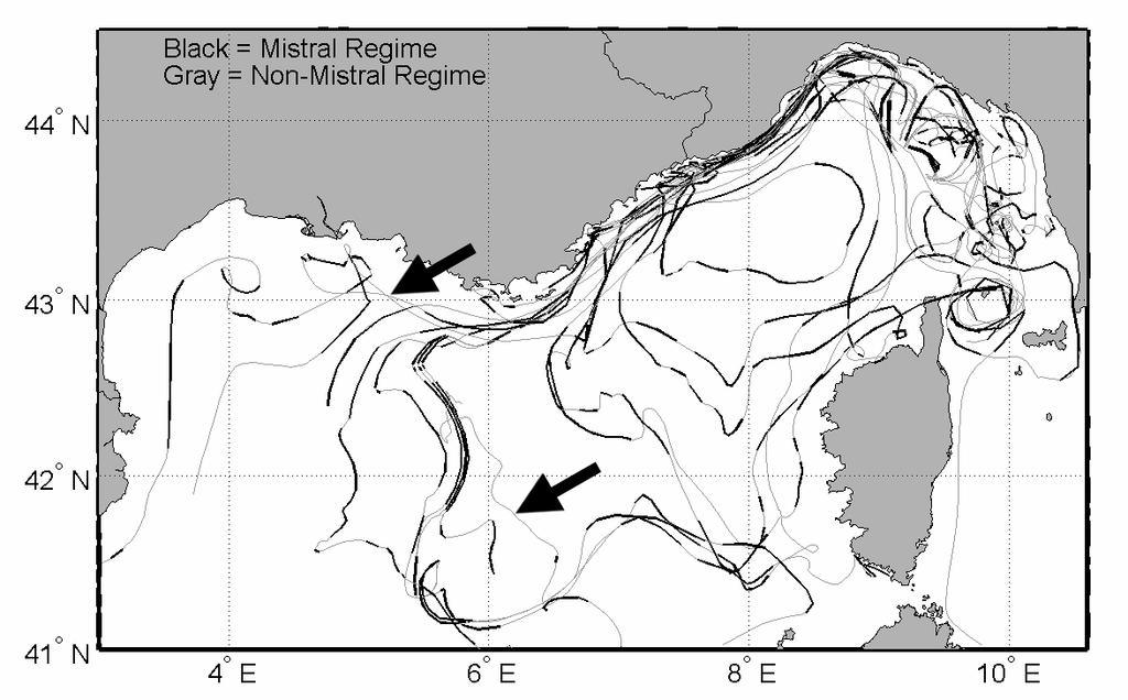
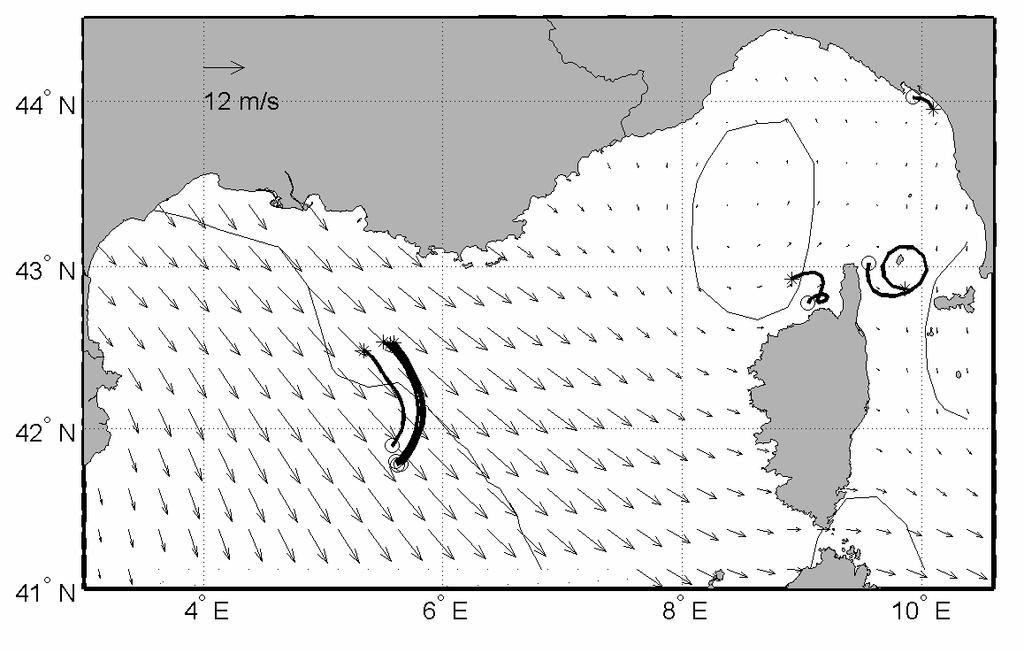
13 The surface speeds measured by the drifters are represented along the tracks in Fig. 4. Fast currents with speeds in excess of 50 cm/s are concentrated in the NC and in the the anticyclone located in the Corsica Channel. The maximum sub-inertial speed of 90 cm/s occurred in the NC off the Italian coast. Speeds are also substantial in the WCC and its extension into the NC, and in the Gulf of Lyons. Slow drifter motions are dominant in the eastern part of the LPB north of the Corsica Channel and in some very coastal areas off France and Corsica. The surface drifter motions sorted into Mistral and non-mistral wind regimes are depicted in Fig. 5. It can be seen that the re-circulation or short-cutting of the basinwide cyclonic circulation essentially appears between Corsica and France, and in front of the Gulf of Lyons, only if the Mistral winds are blowing. In contrast, the intrusion of two drifters onto the Gulf of Lyons shelf and the northwestward motion of one unit off the Gulf of Lyons (see black arrows in Fig. 5) occurred in 2008 under non-mistral wind conditions. The surface currents in the eastern Ligurian Sea and in the NC appear less directly influenced by the winds. All the Mistral events concomitant with drifters approaching the Gulf of Lyons were studied in detail. In total, three such events were found for the following periods: 2-6 July 2007, July 2007 and November 2008 (Fig. 6). In all cases, the mean Mistral wind exceeds 10 m/s and the mean wind stress curl changes sign along a line approximately oriented in the northwest-southwest direction and crossing the Gulf of Lyons in its central area, with positive (negative) curl to the east (west) of it. Contemporarily, the drifters move offshore to the south and southeast in the vicinity of the Gulf of Lyons (or more to the east in the Ligurian Sea), hence short-cutting the 13
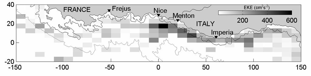
14 LPB basin-wide cyclonic circulation. For two events (28-31 July 2007 and November 2008; Fig. 6b,c) the offshore turning is approximately collocated with the zero wind stress curl curve. Whereas during 2-6 July 2007, the turning appears to the east of this curve in an area characterized by positive wind stress curl (Fig. 6a). 4. Pseudo-Eulerian statistics in the NC The geographical area of the NC between the Gulf of Genoa and the Gulf of Lyons was sampled by several drifters in June-October 2007 and October-November 2008 (see Fig. 2). If the drifter data are considered in bins of 10 km (along-shore direction) by 5 km (across-shore direction), the data density, i.e., the number of drifter 6-hourly observations, can be as large as in local coastal areas such as near Menton-Nice and Fréjus (Fig. 7). In contrast, the density remains low in areas where the currents are swift and the drifters move fast in and out of the bins. As a practical rule, we consider only the bins with at least 3 drifter observations to compute the velocity statistics. Note that the number of independent drifter observations might be less than the values depicted in Fig. 7 since observations separated by small temporal (e.g., 6 h) and spatial distances can be correlated. The averaging in bins allows to separate the kinetic energy of the surface currents into two components, the energy of the mean flow (MKE) and the energy of the fluctuations (EKE). The MKE (Fig. 8) is large in the NC west of about x = 100 km, all the way to the Gulf of Lyons. It is maximum (~1800 cm 2 /s 2 ) close to the coast near Imperia. Off France, the large MKE appears a little more offshore, more or less centered on the continental slope. Small values of MKE occur in the eastern area (near Genoa, x > 100 km) and in the coastal areas off Menton-Nice and Fréjus, all these areas being characterized by more abundant data (Fig. 7). The EKE (Fig. 9) is large in 14
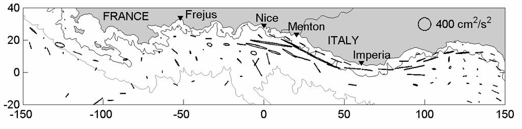
15 the area off Menton-Nice with values approaching (~700 cm 2 /s 2 ). It is also significant east of Menton in a narrow coastal (~10 km wide) band extending almost to Genoa. In the eastern region of the domain where the NC originates, mean currents (Fig. 10) are towards the coast and then westward, and have amplitude varying in 7-21 cm/s. Following the flow towards the west, the NC is seen to strengthen in a coastal strip (< km from shore) in water depth less than 200 m. The bin-averaged speed is maximal (~60 cm/s) in front of Imperia, that is in the same area where the maximum 6-hourly speed was found (Fig. 4). Upon reaching France off Menton-Nice, the NC decelerates and widens, in correspondence with the general broadening of the continental shelf and slope. Further downstream, the mean currents of the two branches, one entering the Gulf of Lyons and the other proceeding offshore can be as large as 50 cm/s. Reduced or practically no mean flow characterize the local coastal waters near Menton-Nice and Fréjus, inshore of the NC. Velocity variance ellipses (Fig. 11) confirms the dominance of the variability near the Italian coast (more or less inshore of the 200 m isobath) and the more extended maximum off Menton and Nice. The large eccentricity of the ellipses indicate that the fluctuating currents are essentially polarized and oriented parallel to the coast. There is a slight trace of cross-shore variability off Menton-Nice where the ellipses are less elongated. If the along-shore velocities are considered and averaged in elongated bins parallel to the coast (size of 4 km by 30 km and overlapping by 50%) in selected areas such as 30 km-wide regions off Imperia, Menton-Nice and Fréjus (Fig. 12), the following results are obtained: 1) The NC off Imperia (Fig. 12a) is limited within km 15
16 from shore above the continental slope. Its core with maximal (individual near 90 cm/s and averaged near 50 cm/s) and highly variable speeds is located between the coast and about 10 km offshore, in water depths less than 200 m; 2) Further to the west (Fig. 12b,c), the continental slope is less abrupt and the NC widens, weakens (average speeds less than 50 cm/s) and moves offshore between 15 and 35 km from the coast. In front of Menton-Nice (Fig. 12b) the currents are higly variable between 10 and 20 km from the coast, whereas off Fréjus (Fig. 12c) the currents are weak (averaged speed less than 10 cm/s) from the coast to about 10 km offshore. 5. Discussion and conclusions Satellite-tracked drifters were used to study the surface circulation in the LPB between May 2007 and January The drifters revealed a complex circulation in the eastern Ligurian Sea north of Corsica and a very weak signature of the ECC (Fig. 4). Instead, the transport through the Corsica Channel appears to be limited due to the prevalence of an anticyclonic eddy in summer The reduced connection between the Tyrrhenian and Ligurian seas in summer is in agreement with the results of Astraldi and Gasparini (1992), Astraldi et al. (1990) and the simulations of Pinardi and Masetti (2000). In contrast, the WCC is well delineated by the drifters with northward surface currents reaching 50 cm/s (Fig. 4). Most of the drifters deployed in the Ligurian Sea eventually ended up in the NC, a strong southwestward coastal current forming in the Gulf of Genoa and extending as far west as the Gulf of Lyons. Surface speeds in the NC can be as large as 90 cm/s, especially off Imperia where the NC core is narrow and located less than 10 km from the coast (Figs. 4, 10 and 12). Further to the west, in front of Menton-Nice, the NC is slightly weaker (speeds <= 50 cm/s) and broader (extending between 15 and 35 km from the coast; Fig. 12). The 16
17 currents inshore of the NC are highly variable. These results are compatible with those of Béthoux et al. (1988) and Sammari et al. (1995). Off Fréjus, the NC is still mainly located between 15 and 35 km from shore, but the inshore area is characterized by sluggish currents (resulting in a stagnation area where some drifters ultimately stranded or were picked up). Upon reaching the Gulf of Lyons, some drifters (those deployed in 2007, see Fig. 3a,b,c) moved offshore to the south-southeast and proceeded towards Corsica. They joined the WCC and closed a basin-wide cyclonic gyre in the LPB. It was shown that the recirculation or the offshore currents at the level of the Gulf of Lyons mainly occur during Mistral events (Figs. 5 and 6). In contrast, if the Mistral is not prevailing, the drifters continued moving towards the southwest on the continental slope and eventually entered the Gulf of Lyons before proceeding in the direction of the Catalan Sea (see the drifters deployed in 2008 in Fig. 3d,e,f). We therefore conclude that the Mistral winds are mainly responsible for the closing of the LPB cyclonic gyre between longitudes 5-6 E and for the formation of smaller subgyres such as the Ligurian-wide gyre of Fig. 3b. This recirculation was already noted by Ovchinnikov (1966) using hydrographic data, Pinardi and Navarra (1993) and Molcard et al. (2002) in wind driven numerical simulations of the Mediterranean Sea. The existence of a large-scale cyclonic circulation encompassing all the LPB, the area off the Gulf of Lyons and the Catalan Sea as shown in the historical (Crépon and al., 1982) and satellite altimeter (Pujol, 2006) maps is therefore not verified by the drifters. It is noticeable that the Mistral wind stress curl has its zero crossing line around 5-6 o E (Molcard et al., 2002; Fig. 7b,c) and this might induce the early closing of the LPB wide circulation into a smaller gyre, as mapped in Figs. 3b and 6a. The 17
18 position of the offshore turning of the sub-gyre is also about at the location of the Rhone Fan, a very important bathymetric structure developed from the centre of the Gulf of Lyons shelf to deep ocean (Madec et al., 1991). This bottom structure helps to form a stable cyclonic circulation eastward of the fan and that could produce the offshore turning of the drifters. This coincidence should be better explored in the future process models of the LPB basin scale circulation. Pseudo-Eulerian statistics (Figs. 7 to 11) focused on the area coastal area between the Gulf of Genoa and Gulf of Lyons, quantified some of the characteristics of the NC mentioned above. In particular, fast currents and maximal MKE (~1800 cm 2 /s 2 ) occur off Imperia, whereas small mean currents prevail off Menton-Nice and Fréjus. The latter areas are also characterized by a high density of observations, and high probability of stranding and pick up near Fréjus, indicating that drifters deployed offshore do enter them. The EKE and velocity variance ellipses are large along the coast between Imperia and Nice (maximum ~700 cm 2 /s 2 ). The ellipses are mainly oriented along the coast. They correspond to variations at temporal scales ranging between a few days to a few months and exclude seasonal variability. Acknowledgements We thank the following collaborators for their help with the drifter deployment and recovery operations: Craig Lewis, Anne Molcard, Joel Gaggelli, Nicoletta Fabbroni, Fabio Brunetti, Nevio Medeot and the captains and crew members of R/V Urania and Italian Navy vessels Galatea and Magnaghi. Cross-Calibrated, Multi-Platform Ocean Surface Wind Velocity (CCMP) products were obtained from the PO.DAAC web page: A. Griffa was supported by ONR grant N and by the EC ECOOP project. 18
19 References Astraldi, M., Gasparini, G.P., Manzella, G. and Hopkins, T.S., Temporal variability of currents in the Eastern Ligurian Sea. Journal of Geophysical Research, 95 (C2), Astraldi, M. and Gasparini, G. P., The seasonal characteristics of the circulation in the North Mediterranean basin and their relationship with the atmospheric climatic conditions. Journal of Geophysical Research, 97 (C6), Atlas, R., Ardizzone, J.V., Hoffman, R., Jusem, J.C. and Leidner, S.M., Crosscalibrated, multi-platform ocean surface wind velocity product (MEaSUREs Project). Guide Document. Physical Oceanography Distributed Active Archive Center (PO.DAAC). JPL, Pasadena, California, 18 May 2009, Version 1.0., 26p. Barbanti, R., Iungwirth, R. and Poulain, P.-M., Stima dell'accuratezza del drifter tipo CODE con GPS nella determinazione della posizione geografica, Rel. 32/2005/OGA/20, OGS, Trieste, Italy. Béthoux, J.-P., Prieur, L. and Bong, J.-H., Le courant Ligure au large de Nice. Oceanologica Acta (n spécial), Birol, F., Cancet, M. and Estournel, C., Aspects of the seasonal variability of the Northern Current (NW Mediterranean Sea) observed by altimetry. Journal of Marine Systems. Submitted. 19
20 Crépon, M., Wald, L. and Monget, J.-M., Low-frequency waves in the Ligurian Sea during December Journal of Geophysical Research, 87 (C1), Crépon, M. and Boukthir, M., Effect of deep water formation on the circulation of the Ligurian Sea. Annales Geophysicae, 5B (1) Davis, R. E., Drifter observation of coastal currents during CODE. The method and descriptive view. Journal of Geophysical Research, 90, Echevin, V., Crépon, M., and Mortier, L., Simulation and analysis of the mesoscale circulation in the northwestern Mediterranean Sea. Annales Geophysicae, 21: Fabbroni, N Numerical simulations of passive tracers dispersion in the Sea. Ph.D. Thesis, University of Bologna. 164p. Hansen, D.V., and Poulain, P.-M., Processing of WOCE/TOGA drifter data, Journal of Atmospheric and Oceanic Technology, 13, Haza, A.C., Ozgokmen, T.M., Griffa, A., Molcard, A., Poulain, P.-M. and Peggion, G., Transport properties in small scale flows: relative dispersion from VHF radar measurements in the Gulf of La Spezia. Ocean Dynamics. Submitted. Herbaut, C., Mortier, L. and Crépon, M., A sensitivity study of the general circulation of the western Mediterranean. Part II: the response to atmospheric forcing. Journal of physical Oceanography 27,
21 Madec, G., Chartier, M. and Crépon, M., The effect of thermohaline forcing variability on deep water formation in the western Mediterranean Sea: a highresolution three-dimensional numerical study. Dynamics of the Atmosphere and Oceans, MEDOC Group, Observation of formation of deep water in the Mediterranean, Nature, 227, Millot, C., The structure of mesoscale phenomena in the Ligurian Sea inferred from the DYOME esperiment. Annales Geophysicae, 5B (1), Millot, C., Mesoscale and seasonal variabilities of the circulation in the western Mediterranean. Dynamics of Atmospheres and Oceans, 15 (3-5), Millot, C. and Wald, L., The effect of Mistral wind on the Ligurian current near Provence. Oceanologica Acta, 3 (4), Molcard, A., Pinardi, N., Iskandarami, M., Haidvogel, D.B., Wind driven general circulation of the Mediterranean Sea simulated with a Spectral Element Ocean Model. Dynamics of Atmosphere and Oceans, 17, pp Molcard, A., Poulain, P.-M., Forget, P., Griffa, A., Barbin, Y., Gaggelli, J., De Maistre, J.C., and Rixen, M., Comparison between VHF radar observations and data from drifter clusters in the Gulf of La Spezia (Mediterranean Sea). Journal of Marine Systems, 78 (Supplement 1), S79-S89. 21
22 Mounier, F., Echevin, V., Mortier, L. and Crépon, M., Analysis of the mesocale circulation in the occidental Mediterranean Sea during winter given by a regional circulation model. Progress in Oceanography, 66, Ohlmann, J.C., Niiler, P.P., Fox, C.A. and Leben, R.R Eddy energy and shelf interactions in the Gulf of Mexico. Journal of Geophysical Research, 106, Ovchinnikov, I. M., Circulation in the surface and intermediate layers of the Mediterranean, Oceanology, 6, Pazan, S. E. and Niiler, P. P., Recovery of near-surface velocity from undrogued drifters. Journal of Atmospheric and Oceanic Technology, 18, Pinardi, N. and A. Navarra, Baroclinic wind adjustment processes in the Mediterranean Sea, Deep Sea Research II, Vol. 40, No. 6, Pinardi, N., Masetti, E, Variability of the large-scale general circulation of the, Mediterranean Sea from observations and modelling: a review. Palaeogeography, Palaeoclimatology, 158, pp Pinardi, N., E. Arneri, A. Crise, M. Ravaioli and M. Zavatarelli, The physical, sedimentary and ecological structure and variability of shelf areas in the Mediterranean Sea. The Sea Vol. 14 (A. R. Robinson and K. Brink Eds.), Harvard University Press, Cambridge, USA,
23 Poulain, P.-M., Drifter observations of surface circulation in the Adriatic Sea between December 1994 and March J. Marine Sys., 20, Poulain, P.-M., Adriatic Sea surface circulation as derived from drifter data between 1990 and 1999, J. Marine Sys., 29, Poulain, P.-M., Gerin, R., Mauri, E., and Pennel, R., Wind effects on drogued and undrogued drifters in the Eastern Mediterranean. Journal of Atmospheric and Oceanic Technology, 26 (6), Pujol, M.-I., Analyse de la variabilité de surface en Méditerranée à partir des données altimétriques et comparaison aux simulations MERCATOR et MOG2D. Thèse de Doctorat. Université Toulouse III Paul Sabatier U.F.R. P.C.A., 307p. Rinaldi, E., Buongiorno Nardelli, B., Zambianchi, E., Santoleri, R. and Poulain, P.- M., Lagrangian and Eulerian observations of the surface circulation in the Tyrrhenian Sea. Journal of Geophysical Research. Submitted. Rio, M.H, Poulain, P.M., Pascual, A., Mauri, E., Larnicol, G. and Santoleri, R., A mean dynamic topography of the Mediterranean Sea computed from altimetric data, in-situ measurements and a general circulation model. J. Marine Syst. 65 (1 4), Sammari, C., Millot, C. and Prieur, L., Aspects of the seasonal and mesoscale variabilities of the Northern current in the western Mediterranean Sea inferred from the PROLIG-2 and PROS-6 experiments. Deep-Sea Research I, 42(6),
24 Schroeder, K., Griffa, A. and Poulain, P.-M., Relative dispersion in the Ligurian Sea derived from surface drifters. Submitted. Taupier-Letage, I. and Millot, C., General hydrodynamical features in the Ligurian Sea inferred from the DYOME experiment. Oceanologica Acta, 9 (2), Teixeira, J., LASIE07 Trial Plan. NATO Undersea Research Centre, La Spezia, Italy. 30 pp. Ursella, L., Poulain, P.-M. and Signell, R. P., Surface drifter derived circulation in the northern and middle Adriatic Sea: Response to wind regime and season, J. Geophys. Res., 111, C03S04, doi: /2005jc003177, [printed 112(C3), 2007]. Vandenbulcke, L., Beckers, J.-M., Lenartz, F., Barth, A., Poulain, P.-M., Aidonidis, M., Meyrat, J., Ardhuin, F., Tonani, M., Fratianni, C., Torrisi, L., Pallela, D., Chiggiato, J., Tudor, M., Book, J.W., Martin, P., Peggion, G. and Rixen, M. (2009) Super-ensemble techniques: Application to surface drift prediction. Progress In Oceanography, 82 (3),
25 Figure captions Fig. 1. Composite diagram with all the drifter trajectories (back: MREA-07 and LASIE-07 and gray : MREA-08) in the LPB between 14 May 2007 and 23 January Star and open circle symbols indicate the deployment and last positions for each drifter, respectively. The area of the NC extending between the Gulf of Genoa and the Gulf of Lyons is depicted with a dashed rectangle. Fig. 2. Temporal distribution of the drifter data in the LPB: number of drifter-days per day (top panel) and per month (independently of the year; bottom panel). The embedded gray bars correspond to the area of the NC extending between the Gulf of Genoa and the Gulf of Lyons (see dashed rectangle in Fig. 1). Fig. 3. Trajectories of the drifters sorted by deployment episodes/clusters listed in Table 1. Star and open circle symbols indicate the deployment and last positions for each drifter, respectively. Fig. 4. Segments of drifter trajectories sorted by drifter speed in the LPB. The maximum sub-inertial speed of 90 cm/s occurred in the NC off the Italian coast (marked by a white dot). Fig. 5. Segments of drifter trajectories sorted by wind regimes. Wind regimes are defined considering the CCMP winds at 41 N52.5 and 5 E52.5 and sorting them into two categories (Mistral: winds blowing from the entire northwestern sector with speeds in excess of 5 m/s; Non-Mistral: winds with speeds less than 5 m/s and 25
26 blowing from the other sectors. Black arrows indicate northwestward drifter motion into and towards the Gulf of Lyons when Mistral is not blowing. Fig. 6. CCMP winds averaged over the periods of prevailing Mistral winds: (a) 2-6 July 2007, (b) July 2007 and (c) November The zero wind stress curl lines are also depicted, as well as segments of drifter trajectories corresponding to the time periods (star and open circle symbols indicate the first and last positions for each drifter, respectively). Fig. 7. Drifter data density in the NC area extending between the Gulf of Genoa and the Gulf of Lyons: number of 6-hourly observations in bins of 10 x 5 km 2 (gray tones). The 200 m and 2200 m isobaths are shown with thin black and gray curves, respectively. Coordinates are in km. Fig. 8. Same as in Fig. 7 but for the kinetic energy of the mean flow (MKE) and considering only bins with at least 3 observations. Fig. 9. Same as in Fig. 8 but for the kinetic energy of the fluctuating velocities (EKE). Fig. 10. Mean circulation in the NC area extending between the Gulf of Genoa and the Gulf of Lyons (vectors) along with the drifter trajectories (light gray). Drifter velocities were averaged in bins of 10 x 5 km 2 containing at least 3 observations. The 200 m and 2200 m isobaths are drawn with thin black and gray curves, respectively. Coordinates are in km. The location of the maximum speed is indicated by a black dot near Imperia. 26
27 Fig. 11. Same as in Fig. 10 but for the velocity variance ellipses. Fig. 12. Along-shore velocities off Imperia (a), Menton-Nice (b) and Fréjus (c) as a function of distance from the coast. Individual velocities in a 30 km-wide band are shown by dots, whereas the bin-averaged (in 30 km by 4 km) are depicted with a solid curve. Bathymetry is shown with gray shading. 27
28 Date Ship Experiment Number of drifters Number of kriged tracks 14-May-2007 ITN Galatea MREA Jun-2007 R/V Urania LASIE Jun-2007 R/V Urania LASIE Oct-2008 ITN Magnaghi MREA Oct-2008 ITN Magnaghi MREA Oct-2008 ITN Magnaghi MREA Total Table 1. Details on the drifter deployments conducted in the open Ligurian Sea from the Italian Navy ships Galatea and Magnaghi and the Italian Consiglio delle Ricerche (CNR) ship Urania during the MREA-07, LASIE-07 and MREA-08 experiments. 28

29 Fig

30 Fig

31 Fig

32 Fig

33 Fig. 4. Fig

34 a b Fig

35 c Fig


36 Fig. 7. Fig. 8. Fig

37 Fig. 10. Fig
38 38

39 Fig
Title: Surface circulation in the Liguro-Provencal basin as measured by satellite-tracked drifters ( )
") Editorial Manager(tm) for Ocean Dynamics Manuscript Draft Manuscript Number: Title: Surface circulation in the Liguro-Provencal basin as measured by satellite-tracked drifters (0-0) Article Type: Original
Editorial Manager(tm) for Ocean Dynamics Manuscript Draft Manuscript Number: Title: Surface circulation in the Liguro-Provencal basin as measured by satellite-tracked drifters (0-0) Article Type: Original
Surface Circulation in the Northeastern Mediterranean (NEMED)
") DISTRIBUTION STATEMENT A. Approved for public release; distribution is unlimited. Surface Circulation in the Northeastern Mediterranean (NEMED) Pierre-Marie Poulain Istituto Nazionale di Oceanografia e
DISTRIBUTION STATEMENT A. Approved for public release; distribution is unlimited. Surface Circulation in the Northeastern Mediterranean (NEMED) Pierre-Marie Poulain Istituto Nazionale di Oceanografia e
ON THE CYPRUS EDDY KINEMATICS
 ON THE CYPRUS EDDY KINEMATICS Arthur Prigent 1,2 and Pierre-Marie Poulain 1 1 Istituto Nazionale di Oceanografia e di Geofisica Sperimentale (OGS), Trieste, Italy 2 Ecole Nationale Supérieure de Techniques
Impact of the tides, wind and shelf circulation on the Gironde river plume dynamics
 Impact of the tides, wind and shelf circulation on the Gironde river plume dynamics F. Toublanc 1, N. Ayoub 2, P. Marsaleix 3, P. De Mey 2 1 CNES/LEGOS 2 CNRS/LEGOS 3 CNRS/LA, Toulouse, France 5th GODAE
Variability of surface transport in the Northern Adriatic Sea from Finite-Size Lyapunov Exponents" Maristella Berta
 Variability of surface transport in the Northern Adriatic Sea from Finite-Size Lyapunov Exponents" Maristella Berta Marseille, 29 November 2011 Outline Geographical setting (winds and circulation of Adriatic
THE CIRCULATION IN THE NORTERN PART OF THE DENMARK STRAIT AND ITS VARIABILITY ABSTRACT
 ICES em 19991L:06 THE CIRCULATION IN THE NORTERN PART OF THE DENMARK STRAIT AND ITS VARIABILITY Steingrimur J6nsson Marine Research Institute and University of Akureyri, Glenirgata 36, 600 Akureyri, Iceland,
Coastal Ocean Circulation Experiment off Senegal (COCES - II)
") DISTRIBUTION STATEMENT A. Approved for public release; distribution is unlimited. Coastal Ocean Circulation Experiment off Senegal (COCES - II) Pierre-Marie Poulain Istituto Nazionale di Oceanografia e
DISTRIBUTION STATEMENT A. Approved for public release; distribution is unlimited. Coastal Ocean Circulation Experiment off Senegal (COCES - II) Pierre-Marie Poulain Istituto Nazionale di Oceanografia e
Kathleen Dohan. Wind-Driven Surface Currents. Earth and Space Research, Seattle, WA
 Updates to OSCAR and challenges with capturing the wind-driven currents. Wind-Driven Surface Currents Kathleen Dohan Earth and Space Research, Seattle, WA ENSO OSCAR Surface currents from satellite fields
Currents measurements in the coast of Montevideo, Uruguay
 Currents measurements in the coast of Montevideo, Uruguay M. Fossati, D. Bellón, E. Lorenzo & I. Piedra-Cueva Fluid Mechanics and Environmental Engineering Institute (IMFIA), School of Engineering, Research
3 The monsoon currents in an OGCM
 3 The monsoon currents in an OGCM The observations show that both Ekman drift and geostrophy contribute to the surface circulation in the north Indian Ocean. The former decays rapidly with depth, but the
THE RESPONSE OF THE GULF OF MAINE COASTAL CURRENT SYSTEM TO LATE-SPRING
 THE RESPONSE OF THE GULF OF MAINE COASTAL CURRENT SYSTEM TO LATE-SPRING NORTHEASTERLY WIND FORCING Neal R Pettigrew and Huijie Xue School of Marine Sciences University of Maine, Orono ME 04469 The Gulf
Climatology of the 10-m wind along the west coast of South American from 30 years of high-resolution reanalysis
 Climatology of the 10-m wind along the west coast of South American from 30 years of high-resolution reanalysis David A. Rahn and René D. Garreaud Departamento de Geofísica, Facultad de Ciencias Físicas
An Atlas of Oceanic Internal Solitary Waves (February 2004) by Global Ocean Associates Prepared for Office of Naval Research Code 322 PO
 by Global Ocean Associates Prepared for Office of Naval Research Code 322 PO") Overview The is located in the North Atlantic Ocean between southern Ireland and southwest England (Figure 1). The Sea s western edge covers a continental shelf region characterized by rough and irregular
Overview The is located in the North Atlantic Ocean between southern Ireland and southwest England (Figure 1). The Sea s western edge covers a continental shelf region characterized by rough and irregular
A CYCLONIC EDDY NORTH OF LOMBOK *)
") A CYCLONIC EDDY NORTH OF LOMBOK *) by George Cresswell ABSTRACT A satellite drifter that passed from south to north through Lombok Strait in early 1988 became trapped in a cyclonic eddy 100 km north of
A CYCLONIC EDDY NORTH OF LOMBOK *) by George Cresswell ABSTRACT A satellite drifter that passed from south to north through Lombok Strait in early 1988 became trapped in a cyclonic eddy 100 km north of
Current mooring observations in the area of the South Kuril Islands
 Current mooring observations in the area of the South Kuril Islands Georgy Shevchenko, Gennady Kantakov 2* and Valery Chastikov 2 Institute of Marine Geology and Geophysics FEB RAS, Yuzhno-Sakhalinsk,
Imprints of Coastal Mountains on Ocean Circulation and Variability
 Imprints of Coastal Mountains on Ocean Circulation and Variability Shang-Ping Xie 1 with C.-H. Chang 1, W. Zhuang 2, N. Schneider 1, J. Small 3, B. Taguchi 4, and H. Sasaki 4 1 IPRC, University of Hawaii
Observations and Modeling of Coupled Ocean-Atmosphere Interaction over the California Current System
 Observations and Modeling of Coupled Ocean-Atmosphere Interaction over the California Current System Cape Blanco Dudley Chelton 1, Xin Jin 2, Jim McWilliams 2 & Tracy Haack 3 1 Oregon State University
(20 points) 1. ENSO is a coupled climate phenomenon in the tropical Pacific that has both regional and global impacts.
 1. ENSO is a coupled climate phenomenon in the tropical Pacific that has both regional and global impacts.") SIO 210 Problem Set 4 Answer key December 1, 2014 Due Dec. 12, 2014 (20 points) 1. ENSO is a coupled climate phenomenon in the tropical Pacific that has both regional and global impacts. (2 points) a)
SIO 210 Problem Set 4 Answer key December 1, 2014 Due Dec. 12, 2014 (20 points) 1. ENSO is a coupled climate phenomenon in the tropical Pacific that has both regional and global impacts. (2 points) a)
Observations of Near-Bottom Currents with Low-Cost SeaHorse Tilt Current Meters
 DISTRIBUTION STATEMENT A. Approved for public release; distribution is unlimited. Observations of Near-Bottom Currents with Low-Cost SeaHorse Tilt Current Meters Vitalii A. Sheremet, Principal Investigator
CHAPTER 7 Ocean Circulation
 1 2 3 4 5 6 7 8 9 10 11 12 13 14 CHAPTER 7 Ocean Circulation Words Ocean currents Moving seawater Surface ocean currents Transfer heat from warmer to cooler areas Similar to pattern of major wind belts
2 Observations. 2.1 Ekman drift
 2 Observations To define the monsoon currents and the associated circulation in the north Indian Ocean, we use climatological wind-stress data to estimate the surface Ekman drift, and hydrography and altimeter
Effects of very harsh 2012 winter conditions on the deep layer of the Southern Adriatic Sea
 Effects of very harsh 2012 winter conditions on the deep layer of the Southern Adriatic Sea Bensi M.*1, Cardin V.1, Rubino A.2, Notarstefano G.1, Poulain P.M.1 1 Istituto Nazionale di Oceanografia e di
Plate 3. CZCS-derived chl Climatological Monthly Means
 Plate 3. CZCS-derived chl Climatological Monthly Means 15 16 2. Interannual variability The assessment of interannual variability in the 1998-2003 SeaWiFSderived data set was carried out by generating
Chapter 22, Section 1 - Ocean Currents. Section Objectives
 Chapter 22, Section 1 - Ocean Currents Section Objectives Intro Surface Currents Factors Affecting Ocean Currents Global Wind Belts (you should draw and label a diagram of the global wind belts) The Coriolis
Geostrophic and Tidal Currents in the South China Sea, Area III: West Philippines
 Southeast Asian Fisheries Development Center Geostrophic and Tidal Currents in the South China Sea, Area III: West Philippines Anond Snidvongs Department od Marine Science, Chulalongkorn University, Bangkok
Wave-Current Interaction in Coastal Inlets and River Mouths
 DISTRIBUTION STATEMENT A. Approved for public release; distribution is unlimited. Wave-Current Interaction in Coastal Inlets and River Mouths Tim T. Janssen Department of Geosciences, San Francisco State
Intraseasonal Variability in Sea Level Height in the Bay of Bengal: Remote vs. local wind forcing & Comparison with the NE Pacific Warm Pool
 Intraseasonal Variability in Sea Level Height in the Bay of Bengal: Remote vs. local wind forcing & Comparison with the NE Pacific Warm Pool Shang-Ping Xie 1,3, Xuhua Cheng 2,3, Julian P. McCreary 3 1.
TRIAXYS Acoustic Doppler Current Profiler Comparison Study
 TRIAXYS Acoustic Doppler Current Profiler Comparison Study By Randolph Kashino, Axys Technologies Inc. Tony Ethier, Axys Technologies Inc. Reo Phillips, Axys Technologies Inc. February 2 Figure 1. Nortek
Prediction of Nearshore Waves and Currents: Model Sensitivity, Confidence and Assimilation
 Prediction of Nearshore Waves and Currents: Model Sensitivity, Confidence and Assimilation H. Tuba Özkan-Haller College of Oceanic and Atmospheric Sciences Oregon State University, 104 Ocean Admin Bldg
IMPACTS OF COASTAL PROTECTION STRATEGIES ON THE COASTS OF CRETE: NUMERICAL EXPERIMENTS
 IMPACTS OF COASTAL PROTECTION STRATEGIES ON THE COASTS OF CRETE: NUMERICAL EXPERIMENTS Tsanis, I.K., Saied, U.M., Valavanis V. Department of Environmental Engineering, Technical University of Crete, Chania,
Variability in the tropical oceans - Monitoring and prediction of El Niño and La Niña -
 Variability in the tropical oceans - Monitoring and prediction of El Niño and La Niña - Jun ichi HIROSAWA Climate Prediction Division Japan Meteorological Agency SST anomaly in Nov. 1997 1 ( ) Outline
SURFACE CURRENTS AND TIDES
 NAME SURFACE CURRENTS AND TIDES I. Origin of surface currents Surface currents arise due to the interaction of the prevailing wis a the ocean surface. Hence the surface wi pattern (Figure 1) plays a key
Impact of Typhoons on the Western Pacific: Temporal and horizontal variability of SST cooling Annual Report, 2011 James F. Price
 DISTRIBUTION STATEMENT A: Distribution approved for public release; distribution is unlimited. Impact of Typhoons on the Western Pacific: Temporal and horizontal variability of SST cooling Annual Report,
The drift of Modified Atlantic Water from the Alboran Sea to the eastern Mediterranean*
 SCI. MAR., 62 (3): 211-216 SCIENTIA MARINA 1998 The drift of Modified Atlantic Water from the Alboran Sea to the eastern Mediterranean* J. FONT 1, C. MILLOT 2, J. SALAS 1, A. JULIÀ 1 and O. CHIC 1 1 Institut
The Coriolis force, geostrophy, Rossby waves and the westward intensification
 Chapter 3 The Coriolis force, geostrophy, Rossby waves and the westward intensification The oceanic circulation is the result of a certain balance of forces. Geophysical Fluid Dynamics shows that a very
JOURNAL OF GEOPHYSICAL RESEARCH, VOL. 107, NO. C11, 3184, doi: /2001jc001190, 2002
 JOURNAL OF GEOPHYSICAL RESEARCH, VOL. 107, NO. C11, 3184, doi:10.1029/2001jc001190, 2002 A modeling study of shelf circulation off northern California in the region of the Coastal Ocean Dynamics Experiment
"Real-Time Vertical Temperature, and Velocity Profiles from a Wave Glider"
 DISTRIBUTION STATEMENT A. Approved for public release; distribution is unlimited. "Real-Time Vertical Temperature, and Velocity Profiles from a Wave Glider" Luca Centurioni Scripps Institution of Oceanography
OPERATIONAL AMV PRODUCTS DERIVED WITH METEOSAT-6 RAPID SCAN DATA. Arthur de Smet. EUMETSAT, Am Kavalleriesand 31, D Darmstadt, Germany ABSTRACT
 OPERATIONAL AMV PRODUCTS DERIVED WITH METEOSAT-6 RAPID SCAN DATA Arthur de Smet EUMETSAT, Am Kavalleriesand 31, D-64295 Darmstadt, Germany ABSTRACT EUMETSAT started its Rapid Scanning Service on September
Alongshore wind stress (out of the page) Kawase/Ocean 420/Winter 2006 Upwelling 1. Coastal upwelling circulation
 Kawase/Ocean 420/Winter 2006 Upwelling 1. Coastal upwelling circulation") Kawase/Ocean 420/Winter 2006 Upwelling 1 Coastal upwelling circulation We found that in the northern hemisphere, the transport in the surface Ekman layer is to the right of the wind. At the bottom, there
Kawase/Ocean 420/Winter 2006 Upwelling 1 Coastal upwelling circulation We found that in the northern hemisphere, the transport in the surface Ekman layer is to the right of the wind. At the bottom, there
RECTIFICATION OF THE MADDEN-JULIAN OSCILLATION INTO THE ENSO CYCLE
 RECTIFICATION OF THE MADDEN-JULIAN OSCILLATION INTO THE ENSO CYCLE By William S. Kessler and Richard Kleeman Journal of Climate Vol.13, 1999 SWAP, May 2009, Split, Croatia Maristella Berta What does give
Unsteady Wave-Driven Circulation Cells Relevant to Rip Currents and Coastal Engineering
 Unsteady Wave-Driven Circulation Cells Relevant to Rip Currents and Coastal Engineering Andrew Kennedy Dept of Civil and Coastal Engineering 365 Weil Hall University of Florida Gainesville, FL 32611 phone:
Modification of the Stratification and Velocity Profile within the Straits and Seas of the Indonesian Archipelago
 DISTRIBUTION STATEMENT A. Approved for public release; distribution is unlimited. Modification of the Stratification and Velocity Profile within the Straits and Seas of the Indonesian Archipelago Amy Ffield
Beach Wizard: Development of an Operational Nowcast, Short-Term Forecast System for Nearshore Hydrodynamics and Bathymetric Evolution
 Beach Wizard: Development of an Operational Nowcast, Short-Term Forecast System for Nearshore Hydrodynamics and Bathymetric Evolution Ad Reniers Civil Engineering and Geosciences, Delft University of Technology
The Setting - Climatology of the Hawaiian Archipelago. Link to Video of Maui Waves
 The Setting - Climatology of the Hawaiian Archipelago Link to Video of Maui Waves What caused this week s weather? What caused this weekend s weather? Today s Objective: Provide overview and description
Geophysical Fluid Dynamics of the Earth. Jeffrey B. Weiss University of Colorado, Boulder
 Geophysical Fluid Dynamics of the Earth Jeffrey B. Weiss University of Colorado, Boulder The Earth is a spinning sphere Coriolis force depends on latitude solar flux depends on latitude Michael Ritter,
Super-parameterization of boundary layer roll vortices in tropical cyclone models
 DISTRIBUTION STATEMENT A. Approved for public release; distribution is unlimited. Super-parameterization of boundary layer roll vortices in tropical cyclone models PI Isaac Ginis Graduate School of Oceanography
Winds and Ocean Circulations
 Winds and Ocean Circulations AT 351 Lab 5 February 20, 2008 Sea Surface Temperatures 1 Temperature Structure of the Ocean Ocean Currents 2 What causes ocean circulation? The direction of most ocean currents
10% water in the world is tied up in the surface ocean currents. (above the pycnocline) Primary source is wind: Westerlies, Trades, Polar Easterlies
 Primary source is wind: Westerlies, Trades, Polar Easterlies") Oceanography Chapter 9 10% water in the world is tied up in the surface ocean currents. (above the pycnocline) Primary source is wind: Westerlies, Trades, Polar Easterlies Coriolis deflects winds (and
Oceanography Chapter 9 10% water in the world is tied up in the surface ocean currents. (above the pycnocline) Primary source is wind: Westerlies, Trades, Polar Easterlies Coriolis deflects winds (and
EARTH, PLANETARY, & SPACE SCIENCES 15 INTRODUCTION TO OCEANOGRAPHY. LABORATORY SESSION #6 Fall Ocean Circulation
 EARTH, PLANETARY, & SPACE SCIENCES 15 INTRODUCTION TO OCEANOGRAPHY LABORATORY SESSION #6 Fall 2017 Ocean Circulation The focus of the Lab this week is circulation of the ocean and atmosphere. Here, you
Lesson: Ocean Circulation
 Lesson: Ocean Circulation By Keith Meldahl Corresponding to Chapter 9: Ocean Circulation As this figure shows, there is a connection between the prevailing easterly and westerly winds (discussed in Chapter
JOURNAL OF GEOPHYSICAL RESEARCH, VOL. 107, NO. C9, 3123, doi: /2000jc000768, 2002
 JOURNAL OF GEOPHYSICAL RESEARCH, VOL. 107, NO. C9, 3123, doi:10.1029/2000jc000768, 2002 A modeling study of shelf circulation off northern California in the region of the Coastal Ocean Dynamics Experiment:
PROC. ITB Eng. Science Vol. 36 B, No. 2, 2004,
 PROC. ITB Eng. Science Vol. 36 B, No. 2, 2004, 133-139 133 Semiannual Kelvin Waves Propagation along the South Coast of Sumatra-Jawa-Bali and the Lesser Sunda Islands Observed by TOPEX/POSEIDON and ERS-1/2
Appendix 5: Currents in Minas Basin. (Oceans Ltd. 2009)
") Appendix 5: Currents in Minas Basin (Oceans Ltd. 29) Current in Minas Basin May 1, 28 March 29, 29 Submitted To: Minas Basin Pulp and Power P.O. Box 41 53 Prince Street Hansport, NS, BP 1P by 22, Purdy
Appendix 5: Currents in Minas Basin (Oceans Ltd. 29) Current in Minas Basin May 1, 28 March 29, 29 Submitted To: Minas Basin Pulp and Power P.O. Box 41 53 Prince Street Hansport, NS, BP 1P by 22, Purdy
Section 1. Global Wind Patterns and Weather. What Do You See? Think About It. Investigate. Learning Outcomes
 Chapter 5 Winds, Oceans, Weather, and Climate Section 1 Global Wind Patterns and Weather What Do You See? Learning Outcomes In this section, you will Determine the effects of Earth s rotation and the uneven
Water circulation in Dabob Bay, Washington: Focus on the exchange flows during the diurnal tide transitions
 Water circulation in Dabob Bay, Washington: Focus on the exchange flows during the diurnal tide transitions Jeong-in Kang School of Oceanography University of Washington (206) 349-7319 nortiumz@u.washington.edu
Upstream environment for SBI - Modeled and observed biophysical conditions in the northern Bering Sea
 Upstream environment for SBI - Modeled and observed biophysical conditions in the northern Bering Sea Jaclyn Clement 1, Wieslaw Maslowski 1, Lee Cooper 2, Jacqueline Grebmeier 2, Waldemar Walczowski 3,
MEAN DISTRIBUTION AND SEASONAL VARIABILITY OF COASTAL CURRENTS AND TEMPERATURE IN THE FLORIDA KEYS WITH IMPLICATIONS FOR LARVAL RECRUITMENT
 BULLETIN OF MARINE SCIENCE, 64(1): 35 56, 1999 MEAN DISTRIBUTION AND SEASONAL VARIABILITY OF COASTAL CURRENTS AND TEMPERATURE IN THE FLORIDA KEYS WITH IMPLICATIONS FOR LARVAL RECRUITMENT Thomas N. Lee
Appendix E Cat Island Borrow Area Analysis
 Appendix E Cat Island Borrow Area Analysis ERDC/CHL Letter Report 1 Cat Island Borrow Area Analysis Multiple borrow area configurations were considered for Cat Island restoration. Borrow area CI1 is located
Seasonal and interannual variation of currents in the western Japan Sea: numerical simulation in comparison with infrared satellite imagery
 Seasonal and interannual variation of currents in the western Japan Sea: numerical simulation in comparison with infrared satellite imagery Olga Trusenkova*, Aleksandr Nikitin**, Vyacheslav Lobanov*, and
Section 6. The Surface Circulation of the Ocean. What Do You See? Think About It. Investigate. Learning Outcomes
 Chapter 5 Winds, Oceans, Weather, and Climate Section 6 The Surface Circulation of the Ocean What Do You See? Learning Outcomes In this section, you will Understand the general paths of surface ocean currents.
Data Analysis of the Seasonal Variation of the Java Upwelling System and Its Representation in CMIP5 Models
 Data Analysis of the Seasonal Variation of the Java Upwelling System and Its Representation in CMIP5 Models Iulia-Mădălina Ștreangă University of Edinburgh University of Tokyo Research Internship Program
Atmospheric Waves James Cayer, Wesley Rondinelli, Kayla Schuster. Abstract
 Atmospheric Waves James Cayer, Wesley Rondinelli, Kayla Schuster Abstract It is important for meteorologists to have an understanding of the synoptic scale waves that propagate thorough the atmosphere
Impact of fine-scale wind stress curl structures on coastal upwelling dynamics : The Benguela system as a case of study.
 IOVWST Meeting May 21, 2015, Portland (OR) Impact of fine-scale wind stress curl structures on coastal upwelling dynamics : The Benguela system as a case of study. Fabien Desbiolles1,2, Bruno Blanke1,
Observations on the circulation of the Saronikos Gulf: A Mediterranean embayment sea border of Athens, Greece
 Click Here for Full Article JOURNAL OF GEOPHYSICAL RESEARCH, VOL. 115,, doi:10.1029/2008jc005026, 2010 Observations on the circulation of the Saronikos Gulf: A Mediterranean embayment sea border of Athens,
Ocean Currents Unit (4 pts)
") Name: Section: Ocean Currents Unit (Topic 9A-1) page 1 Ocean Currents Unit (4 pts) Ocean Currents An ocean current is like a river in the ocean: water is flowing traveling from place to place. Historically,
Name: Section: Ocean Currents Unit (Topic 9A-1) page 1 Ocean Currents Unit (4 pts) Ocean Currents An ocean current is like a river in the ocean: water is flowing traveling from place to place. Historically,
Lecture 13 El Niño/La Niña Ocean-Atmosphere Interaction. Idealized 3-Cell Model of Wind Patterns on a Rotating Earth. Previous Lecture!
 Lecture 13 El Niño/La Niña Ocean-Atmosphere Interaction Previous Lecture! Global Winds General Circulation of winds at the surface and aloft Polar Jet Stream Subtropical Jet Stream Monsoons 1 2 Radiation
SEASONDE DETECTION OF TSUNAMI WAVES
 SEASONDE DETECTION OF TSUNAMI WAVES Belinda Lipa, John Bourg, Jimmy Isaacson, Don Barrick, and Laura Pederson 1 I. INTRODUCTION We here report on preliminary results of a study to assess the capability
Yellow Sea with contributions by John R. Apel
 with contributions by John R. Apel Overview The is a shallow inland sea lying between northeastern China and the Korean Peninsula, with depths in its central north-south trough in excess of 60 to 80 m
Wednesday, September 27, 2017 Test Monday, about half-way through grading. No D2L Assessment this week, watch for one next week
 Wednesday, September 27, 2017 Test Monday, about half-way through grading No D2L Assessment this week, watch for one next week Homework 3 Climate Variability (due Monday, October 9) Quick comment on Coriolis
Outline. 1 Background Introduction. 3 SST Amphidrome 4 Niño Pipe 5. SST in China Seas. Seasonality Spiral. Eddy Tracking. Concluding Remarks
 GHRSST XVIII Outline 1 Background Introduction 2 SST in China Seas 3 SST Amphidrome 4 Niño Pipe 5 Seasonality Spiral 5 stories in S(S)T oceanography 6 7 Eddy Tracking Concluding Remarks 2 Welcome to a
Training program on Modelling: A Case study Hydro-dynamic Model of Zanzibar channel
 Training program on Modelling: A Case study Hydro-dynamic Model of Zanzibar channel Mayorga-Adame,C.G., Sanga,I.P.L., Majuto, C., Makame, M.A., Garu,M. INTRODUCTION Hydrodynamic Modeling In understanding
DUXBURY WAVE MODELING STUDY
 DUXBURY WAVE MODELING STUDY 2008 Status Report Duncan M. FitzGerald Peter S. Rosen Boston University Northeaster University Boston, MA 02215 Boston, MA 02115 Submitted to: DUXBURY BEACH RESERVATION November
Figure 4, Photo mosaic taken on February 14 about an hour before sunset near low tide.
 The Impact on Great South Bay of the Breach at Old Inlet Charles N. Flagg and Roger Flood School of Marine and Atmospheric Sciences, Stony Brook University Since the last report was issued on January 31
Simulation of hydraulic regime and sediment transport in the Mekong delta coast
 Simulation of hydraulic regime and sediment transport in the Mekong delta coast 1. Introduction Coastal erosion in the Mekong Delta has been recorded in recent years and the erosion rate has been increasing
Ocean Circulation. Si Hui Lee and Frances Wen. You can access ME at
 Ocean Circulation Si Hui Lee and Frances Wen You can access ME at http://tinyurl.com/oceancirculation Earth - the blue planet - 71% area covered by the oceans - 3/4 of ocean area between 3000-6000m deep
COMPARISON OF CONTEMPORANEOUS WAVE MEASUREMENTS WITH A SAAB WAVERADAR REX AND A DATAWELL DIRECTIONAL WAVERIDER BUOY
 COMPARISON OF CONTEMPORANEOUS WAVE MEASUREMENTS WITH A SAAB WAVERADAR REX AND A DATAWELL DIRECTIONAL WAVERIDER BUOY Scott Noreika, Mark Beardsley, Lulu Lodder, Sarah Brown and David Duncalf rpsmetocean.com
The impact of ocean bottom morphology on the modelling of long gravity waves from tides and tsunami to climate
 The impact of ocean bottom morphology on the modelling of long gravity waves from tides and tsunami to climate Christian Le Provost and Florent Lyard Laboratoire d Etudes en Géophysique et Océanographie
Study of Passing Ship Effects along a Bank by Delft3D-FLOW and XBeach1
 Study of Passing Ship Effects along a Bank by Delft3D-FLOW and XBeach1 Minggui Zhou 1, Dano Roelvink 2,4, Henk Verheij 3,4 and Han Ligteringen 2,3 1 School of Naval Architecture, Ocean and Civil Engineering,
Lecture 7. More on BL wind profiles and turbulent eddy structures. In this lecture
 Lecture 7. More on BL wind profiles and turbulent eddy structures In this lecture Stability and baroclinicity effects on PBL wind and temperature profiles Large-eddy structures and entrainment in shear-driven
Advection of deep-sea and coastal water into the HNLC region of the northeast Pacific Ocean
 Advection of deep-sea and coastal water into the HNLC region of the northeast Pacific Ocean William Crawford, Nick Bolingbroke William Crawford, Nick Bolingbroke Inst. Ocean Sciences, Sidney, BC, Canada
Statistics of wind and wind power over the Mediterranean Sea
 Conférence Méditerranéenne Côtière et Maritime EDITION 2, TANGER, MAROC (2011) Coastal and Maritime Mediterranean Conference Disponible en ligne http://www.paralia.fr Available online Statistics of wind
Small- and large-scale circulation
 The Earth System - Atmosphere II Small- and large-scale circulation Atmospheric Circulation 1. Global atmospheric circulation can be thought of as a series of deep rivers that encircle the planet. 2. Imbedded
8.4 COASTAL WIND ANOMALIES AND THEIR IMPACT ON SURFACE FLUXES AND PROCESSES OVER THE EASTERN PACIFIC DURING SUMMER
 8.4 COASTAL WIND ANOMALIES AND THEIR IMPACT ON SURFACE FLUXES AND PROCESSES OVER THE EASTERN PACIFIC DURING SUMMER Ragoth Sundararajan * and Darko Koraĉin Desert Research Institute, Reno, NV, USA Michael
Week 6-7: Wind-driven ocean circulation. Tally s book, chapter 7
 Week 6-7: Wind-driven ocean circulation Tally s book, chapter 7 Recap so far Our goal (since week 3) has been to understand large-scale ocean circulation and its underlying physics, and to learn how to
Lagrangian Tracer Transport and Dispersion in Shallow Tidal Inlets & River Mouths
 DISTRIBUTION STATEMENT A: Approved for public release; distribution is unlimited. Lagrangian Tracer Transport and Dispersion in Shallow Tidal Inlets & River Mouths R. T. Guza & Falk Feddersen Scripps Institution
COMPARISON OF DEEP-WATER ADCP AND NDBC BUOY MEASUREMENTS TO HINDCAST PARAMETERS. William R. Dally and Daniel A. Osiecki
 COMPARISON OF DEEP-WATER ADCP AND NDBC BUOY MEASUREMENTS TO HINDCAST PARAMETERS William R. Dally and Daniel A. Osiecki Surfbreak Engineering Sciences, Inc. 207 Surf Road Melbourne Beach, Florida, 32951
Short-period gravity waves over a high-latitude observation site: Rothera, Antarctica
 Short-period gravity waves over a high-latitude observation site: Rothera, Antarctica K. Nielsen, D. Broutman, M. Taylor, D. Siskind, S. Eckermann, K. Hoppel, R. Hibbins, M. Jarvis, N. Mitchell, J. Russell
Pathways and Effects of Indonesian Throughflow water in the Indian Ocean using Trajectory and Tracer experiments in an OGCM
 Pathways and Effects of Indonesian Throughflow water in the Indian Ocean using Trajectory and Tracer experiments in an OGCM Vinu K V Ph.D Student Division of Ocean And Atmospheric Sciences, Hokkaido University,
Structure and discharge test cases
 Chapter 28 Structure and discharge test cases 28.1 Introduction Three test case have been implemented to test the performance and applicability of the structures and discharges modules. drythin Simulates
The GCOOS Mooring Plan Element Draft, 19 February 2011
 The GCOOS Mooring Plan Element Draft, 19 February 2011 1. Introduction In order to proceed with the establishment of a regional coastal ocean observing system for the Gulf of Mexico, it is essential to
Modelling study of the dispersal of pollutants at SHo Jacinto submarine outfall (Aveiro, Portugal)
") Modelling study of the dispersal of pollutants at SHo Jacinto submarine outfall (Aveiro, Portugal) M. Ramosl, M. Almeidal, P. Silval, J. Dubertl & J. Antunes do Carrno2 l Department of Physics, University
Modelling study of the dispersal of pollutants at SHo Jacinto submarine outfall (Aveiro, Portugal) M. Ramosl, M. Almeidal, P. Silval, J. Dubertl & J. Antunes do Carrno2 l Department of Physics, University
Orographic influences on the Adriatic sirocco wind
 European Geosciences Union 2007 Annales Geophysicae Orographic influences on the Adriatic sirocco wind Z. Pasarić, D. Belušić, and Z. B. Klaić Department of Geophysics, Faculty of Science, University of
Subsurface Ocean Indices for Central-Pacific and Eastern-Pacific Types of ENSO
 Subsurface Ocean Indices for Central-Pacific and Eastern-Pacific Types of ENSO Jin-Yi Yu 1*, Hsun-Ying Kao 1, and Tong Lee 2 1. Department of Earth System Science, University of California, Irvine, Irvine,
Monday, October 2, Watch for new assessment (Week 4/5 review) TA s have your tests, please see key (at course website)
 TA s have your tests, please see key (at course website)") Monday, October 2, 2017 Watch for new assessment (Week 4/5 review) TA s have your tests, please see key (at course website) Homework 3 Due date Wednesday, Oct 11 (8 pm) Be ready to watch another important
Monday, October 2, 2017 Watch for new assessment (Week 4/5 review) TA s have your tests, please see key (at course website) Homework 3 Due date Wednesday, Oct 11 (8 pm) Be ready to watch another important
RCEX: Rip Current Experiment
 RCEX: Rip Current Experiment Jamie MacMahan Oceanography Department, Spanagel 327c, Building 232 Naval Postgraduate School, Monterey, CA 93943 Phone: (831) 656-2379 Fax: (831) 656-2712 Email: jhmacmah@nps.edu
ASL Environmental Sciences inc.
 A Member of the SNC LAVALIN Group ASL Environmental Sciences inc. Gros Cacouna LNG Terminal Final report Drifter tracking study 501728 December 2004 Rev. 02 ENVIRONMENT Drifter tracking study Procean
SIO 210 Final examination Wednesday, December 11, PM Sumner auditorium Name:
 SIO 210 Final examination Wednesday, December 11, 2013 2-5 PM Sumner auditorium Name: Turn off all phones, ipods, etc. and put them away. This is a closed book exam. You may use one page of notes, both
Inlet Management Study for Pass-A-Grille and Bunces Pass, Pinellas County, Florida
 Inlet Management Study for Pass-A-Grille and Bunces Pass, Pinellas County, Florida Final Report Submitted By Ping Wang, Ph.D., Jun Cheng Ph.D., Zachary Westfall, and Mathieu Vallee Coastal Research Laboratory
State Estimation of the California Current System Using 4DVar Ocean Data Assimilation
 State Estimation of the California Current System Using 4DVar Ocean Data Assimilation Hajoon Song, Arthur J. Miller and Bruce Cornuelle Scripps Institution of Oceanography, UCSD International Workshop
Morphological Evolution Near an Inlet
 DISTRIBUTION STATEMENT A. Approved for public release; distribution is unlimited. Morphological Evolution Near an Inlet Steve Elgar Woods Hole Oceanographic Institution, MS11 Woods Hole, MA 02543 phone: