SAN DIEGO HARBOR SAFETY PLAN Approved January 2015
|
|
|
- Damon Walton
- 6 years ago
- Views:
Transcription

1 SAN DIEGO HARBOR SAFETY PLAN Approved January 2015 Mandated by California Oil Spill Prevention and Response Act of 1990 Notice of Disclaimer of Liability: This publication is not intended for navigational use, and should not be used for such purpose. For navigation information for San Diego Bay and surrounding environs mariners should refer to safety chart, Notices to Mariners, the Coast Pilot and/or Pilotage guides. The San Diego Harbor Committee assumes no liability for damages arising in connection with the use of this publication, and such liability is hereby expressly disclaimed.
2 TABLE OF CONTENTS Quick Reference Pull Out Guides EMERGENCY RESPONSE PROCEDURES... IV BEST MARITIME PRACTICES... V EXECUTIVE SUMMARY... 1 INTRODUCTION... 1 SCOPE OF THE HARBOR SAFETY PLAN... 1 SUMMARY OF THE HARBOR SAFETY PLAN... 5 SAN DIEGO HARBOR SAFETY COMMITTEE ORGANIZATION AND MEMBERSHIP... 6 GENERAL INFORMATION ABOUT SAN DIEGO BAY... 7 I. GEOGRAPHICAL BOUNDARIES... 8 II. HARBOR CONDITIONS... 9 GENERAL WEATHER, TIDE, CURRENT, AND SEA CONDITIONS OF SAN DIEGO HARBOR... 9 DESCRIPTION OF HARBOR DEPTHS, BERTHS, DREDGING, CHANNEL CONDITIONS SPECIAL NAVIGATION CONDITIONS MARITIME SECURITY CONDITIONS & MARITIME TRANSPORTATION SECURITY ACT OF III. AIDS TO NAVIGATION EVALUATION OF NAVIGATIONAL HAZARDS ACTION SUMMARY ON AIDS TO NAVIGATION IV. ANCHORAGES AND ANCHORAGE MANAGEMENT GENERAL PROCEDURES SPECIAL ANCHORAGES FOR U.S. GOVERNMENT VESSELS "B" STREET MERCHANT VESSEL ANCHORAGE ANCHORAGES FOR GENERAL USE SMALL CRAFT MOORING AND ANCHORAGE AREAS ANCHORAGE LIMITATIONS V. COMMUNICATIONS RADIO COMMUNICATIONS CELLULAR PHONES COMMUNICATION PROBLEMS VI. VESSEL TRAFFIC PATTERNS EVALUATION COMMERCIAL VESSELS MILITARY VESSELS RECREATIONAL BOATING SUMMARY OF VESSEL TRAFFIC AND CARGO LIMITED ACCESS AREAS SMALL VESSEL TRAFFIC EFFECTS ON SAFETY BOATER EDUCATION ACCIDENTS AND NEAR ACCIDENTS EMERGENCY ROUTING PROCEDURES FEDERAL, STATE, AND LOCAL LAWS San Diego Harbor Safety Plan Approved January 2015 i
3 VII. TUG ASSIST/ESCORT EVALUATION TUG EQUIPMENT STEERING AND STOPPING EFFECTIVENESS OF TUGS TUG MANNING VIII. VESSEL TRAFFIC SERVICE IX. BRIDGE MANAGEMENT REQUIREMENTS X. COMPETITIVE ASPECTS XI. PROJECT FUNDING SAN DIEGO MARINE INFORMATION SYSTEM PROJECT FUNDING BOATER EDUCATION XII. ENFORCEMENT XIII. HARBOR SAFETY COMMITTEE RECOMMENDATIONS AND ACCOMPLISHMENTS SAFETY AND NAVIGATION RECOMMENDATIONS BOATER EDUCATION RECOMMENDATIONS HARBOR SAFETY COMMITTEE ACCOMPLISHMENTS XIV. IMPLEMENTATION XV. APPLICABLE REGULATIONS AND GUIDELINES GUIDELINES FOR UNDERKEEL CLEARANCE IN SAN DIEGO BAY NON-TANK VESSEL CONTINGENCY PLAN REGULATIONS TUG ESCORT REGULATIONS FOR TANK VESSELS XVI. MISCELLANEOUS PILOTAGE EVALUATION VESSEL BALLAST PROCEDURES AND REQUIREMENTS LIMITED VISIBILITY GUIDELINES OTHER NAVIGATIONAL SAFETY CONCERNS: UNDERWATER OIL PIPELINES San Diego Harbor Safety Plan Approved January 2015 ii
4 APPENDICES Appendix A: Harbor Safety Committee Membership List A-1 Past Committee/Subcommittee Chairs Appendix B: Tug Escort Regulations, As Amended in 2005 B-1 Appendix C: Boater Education Materials: C-1 (1) Rule 9 Rules of the Road Poster (2) Guide to Boater Safety brochure Appendix D: Port of San Diego Vessel and Fuel Barge Calls, D-1 Appendix E: Port of San Diego Cargo and Fuel Volume Reports, E-1 Appendix F: Naval Ship Movements for F-1 Appendix G: Navy Fuel Depot Totals for G-1 Appendix H: Coast Guard Summary of Marine Casualty Statistics, H-1 Appendix I: Coast Guard Summary of Spills and Incidents, I-1 Appendix J: San Diego Harbor Safety Committee Bylaws J-1 Appendix K: List of Archive Items K-1 Appendix L: Office of Spill Prevention and Response Strategy for L-1 Implementation of San Diego Harbor Safety Plan, February 14, 1996 Appendix M: List of San Diego Harbor Safety Plan Annual Review Dates and M-1 Plan Changes Appendix N: Maritime Information: Federal, State, and Local Agency Websites N-1 Appendix O: U.S. Coast Guard Waterways Analysis and Management (WAMS) O-1 San Diego Harbor Safety Plan Approved January 2015 iii
5 EMERGENCY RESPONSE PROCEDURES Red Tab Pull Out Section In order to provide protection to the sensitive resources in San Diego Bay, it s essential that every effort be made to prevent illegal discharges to the water, and respond to other emergencies that may result in environmental impacts. When such an incident does occur, however, it s critical to make sure it s reported immediately, and to the right agency. The following user-friendly guide provides the necessary information. The vessel master, owner, operator or other responsible party shall take immediate action to contain and control the spill incident, without risking personal health and safety. When onscene, Coast Guard Sector San Diego (oil spills) or the San Diego Fire Department (HAZ-MAT spills) will assume responsibilities as On-Scene Incident Commander until response actions are complete. Anyone causing, observing, or discovering a hazadous spill emergency situation CALL IMMEDIATELY: 1. U.S. Coast Guard Sector San Diego (619) State Office of Emergency Services (OES) (800) OILS-911 ( ) 3. USCG National Response Center and Terrorist Hotline (NRC) (800) Provide as much information as possible including location, type of material (if known),quantity, any immediate threat to life or health, and any impacts to natural resources. Other Important Agencies to Contact S.D. Fire Dept/ Emergency Services (619) Harbor Police (619) Port of San Diego (619) U.S. Navy Port Operations (619) Hr. Navy Regional Duty Office (619) U. S. Coast Guard Waterways Management Division (619) San Diego Harbor Safety Plan Approved January 2015 iv
6 Red Tab Pull Out Section BEST MARITIME PRACTICES INTRODUCTION Best Maritime Practices (BMPs) are accepted and agreed upon methods to conduct vessel transits or operations that are necessary for or enhance the safety of vessels, personnel, dockside facilities and marine resources. These BMP s are not to be considered regulations or laws, but guidelines to assist the mariner with local knowledge while operating in the vicinity of Port of San Diego. This BMP section has been designed as a quick pullout reference guide for safe and environmentally sound vessel movements and operations in and around the port area: The BMPs that are covered in this section include: 1. Important General Information 2. Pre-Arrival Guidelines 3. Vessel Speed and Wake Management 4. Under-keel Clearance 5. Radio Communication 6. Recreational, Naval and Commercial Vessel Interaction 7. Reduced Visibility 8. Heavy Weather Contingency Plans These Best Maritime Practices are intended as a brief guide for the mariners upon San Diego Bay. More detailed and extensive information, regulations and recommendations are found on the following websites. Port of San Diego, Tariff Information, ( Port of San Diego, Port and Harbor Conditions ( NOAA, Office of Coast Survey, Charts and Publications, ( NOAA, Office of Coast Survey, Online Chart Viewer ( USCG Navigation Rules ( San Diego Harbor Safety Plan ( and U.S. Customs & Border Protection ( It is important to note that these BMPs are not intended to be in conflict nor do they replace existing federal, state, and local regulations that are already in place. Nothing in these Best Maritime Practices precludes a master or pilot from taking necessary steps and prudent actions to avoid or mitigate unsafe conditions. San Diego Harbor Safety Plan Approved January 2015 v
7 Red Tab Pull Out Section 1. IMPORTANT GENERAL INFORMATION Please be advised that the Port of San Diego lacks a Vessel Traffic System (VTS). Marine traffic on San Diego Bay is diverse and extensive. It consists of: Naval vessels of all sizes, cargo ships, cruise ships, research ships, tugboats, excursion vessels, commercial fishing and sport fishing vessels, barges, mega yachts and pleasure/recreation boats of every class. Mariners and boaters can expect to find security zones, restricted navigation areas (RNA), special regulated areas and physical barriers to deter unauthorized entry into both water and landside areas of the Port's U.S. naval and military facilities, commercial seaport cargo terminals, cruise ship terminal, and certain other facilities such as sport fishing, harbor excursion and passenger ferry dock areas. Maritime Transportation Security Act (MTSA) regulated facilities in San Diego Bay include: National City Marine Terminal, Tenth Avenue Marine Terminal, Port of San Diego Cruise Ship Terminal (B Street Pier, Broadway Pier, Grape Street Piers), and several sport fishing, excursion vessel and research vessel dockings. Detailed information concerning maritime security programs and regulations (MTSA, TWIC, America's Waterway Watch, Facility Security, etc.) can be found at the U.S. Coast Guard's Homeport - Maritime Transportation Security Act (MTSA) website: Per the Port Tariff, a pilot is required for vessels over 300 gross tons to enter the port. A pilot is recommended for all other non-recreational vessels upon an initial visit to the Port of San Diego. For more details see the Port of San Diego Tariff website ( There is a process for large private yachts to request exemption from pilotage once they have transited San Diego Bay under the observation of a San Diego Bay Pilot. Contact the San Diego Bay Pilots' Association for more information. 2. PRE-ARRIVAL GUIDELINES Notice of Arrivals (NOA) are required for vessels. In general, an NOA is required for any vessel over 300 gross tons, per CFR 33 CFR, Part 160, Subpart C, However, there are additional rules for tugs and barges and any vessel carrying Certain Dangerous Cargoes. The timing of required notice is usually 96 hours, but it may be less depending on the vessel's transit. Refer to the regulations to determine your requirements. Failure to follow the regulations will result in controls placed on the vessel, crew and/or passengers by the U.S. Coast Guard and/or Customs & Border Protection. A Regulated Navigation Area (RNA) is in place for all of San Diego Bay, Mission Bay and their Approaches. Vessels over 100 gross tons must check in with the Captain of the Port or his representative on VHF channel 16 upon entering the Regulated Navigation Area (RNA) as described at 33 CFR The RNA can be seen on NOAA charts and Vessels using the Automatic Identification System (AIS) are exempted from this requirement, as described in 33CFR For additional information about the RNA go to the USCG regulations at: 33 CFR, Part165, subpart B, at the Electronic Code of Federal Regulations website. San Diego Harbor Safety Plan Approved January 2015 vi
8 Red Tab Pull Out Section The best source of local information is the Nautical Chart (41 st Edition, Edition Date: 10/08) and U.S. Coast Pilot 7 ( 41 st Edition, 2009). Make sure your Automatic Identification System (AIS) is updated properly. Please consult the National Vessel Movement Center website at and the NOA regulations 33 CFR, Part 160, Subpart C, at the Electronic Code of Federal Regulations website. 3. SAFE VESSEL SPEED AND WAKE MANAGEMENT a. Safe Vessel Speed As a general rule, the areas of San Diego Bay that are not regulated by a speed zone are to be navigated at a safe and prudent speed with regards to Inland Rule 6 of the U.S. Coast Guard. Every vessel shall at all times proceed at a safe speed so that she can take proper and effective action to avoid collision and be stopped within a distance appropriate to the prevailing circumstances and conditions. In determining a safe speed the following factors shall be among those taken into account: The state of visibility. The traffic density including concentrations of fishing vessels or any other vessels. The manageability of the vessel with special reference to stopping distance and turning ability in the prevailing conditions. At night, the presence of background light such as from shore lights or from back scatter from her own lights. The state of wind, sea and current, and the proximity of navigational hazards. The draft in relation to the available depth of water. South San Diego Bay is governed by a 5 mph speed limit. This is the area delineated by concrete pylons and posted with 5 mph signs. Areas near anchorages are also 5 mph. All lagoons are posted as 5 mph zones. These include the Shelter Island Yacht Basin, the America's Cup Harbor, Harbor Island West and East Lagoons, and Glorietta Bay. For more information about speed limits please consult Coast Pilot 7 (41 st Edition, 2009) for San Diego Bay ( and the Port of San Diego, Tariff Guidelines, Section IV Rules and Regulations (Vessels) at b. Wake Management Generating large wakes can cause excessive damage (and possibly loss of life) at other marine operations on the bay. Every mariner needs to consciously and consistently manage the wake being generated. A large wake would have dangerous impacts on the following areas: near a fuel dock or where a commercial bunkering operation is taking place; while passing a tugboat alongside a ship or barge; near a dry dock operation; by San Diego Harbor Safety Plan Approved January 2015 vii
9 Red Tab Pull Out Section an operating floating crane; and near a dock where passengers are embarking or disembarking a vessel, such as at the Coronado Ferry Terminal. In most cases a reduction of speed will reduce the size of the wake generated. Listen for no wake securite calls on VHF 16 and VHF 13. During bunkering operations make a securite call and request a no wake zone. 4. UNDERKEEL CLEARANCE An Underkeel Clearance of a minimum of 4 feet is required for ship channel entrance, a minimum of 2 feet is required for main ship channel and a minimum 1 foot is required alongside the berth. If a vessel is being moored when the height of tide is critical to keep this vessel in compliance with these under keel clearance guidelines, the vessel s representative should communicate the operations and contingency plan to the Port of San Diego and USCG Captain of the Port. 5. RADIO COMMUNICATIONS All commercial vessels should stand by VHF channels 16 and 13 at all times while underway on San Diego Bay. Calling bridge to bridge via channel 13 initially is most efficient. Recreational vessels with VHF radios are encouraged to monitor 16. US Navy Control One monitors channel 12 and can be a good source for current Naval traffic. Securite calls on channels 16 and 13 are recommended for commercial vessels operating on the bay. 6. RECREATIONAL, NAVAL AND COMMERCIAL VESSEL INTERACTION Interaction implies radio communications, effects of wakes, sound signals, traffic patterns, and blinding halogen deck lights. At all times, the Inland Navigational Rules are applicable to all of San Diego Bay and Mission Bay (33 C.F.R and 33 C.F.R ). The Inland Navigational Rules are found at 33 U.S.C Furthermore, because the Inland Navigational Rules apply to personal water craft (see 33 U.S.C for definition of "vessel"), operators of personal water craft must comply with the Inland Rules of Navigation in Mission Bay and San Diego Bay. a. San Diego Bay and USCG Rule 9 Recreational vessel operators should be sensitive to the fact that large commercial and naval vessels are severely limited in their ability to stop or alter course and many times are limited in their ability to sight small vessels due to "blind spots" that extend more than 1/2 mile ahead, and therefore cannot easily avoid a collision with a smaller, more maneuverable recreational vessel. For your safety, please use caution when crossing San Diego Harbor Safety Plan Approved January 2015 viii
10 Red Tab Pull Out Section their path or when navigating in close proximity to large commercial vessels or navy vessels. Small vessels, according to Rule 9, shall remain clear of large commercial and naval vessels that for navigational safety and the practice of prudent seamanship navigate primarily within the main channel. Tugs with tows have limited maneuverability. Be aware of ships and tugs coming up behind you in the main channel. Per the Coast Guard Captain of the Port, the shipping channels of San Diego Harbor are considered "Narrow Channels" for the purposes of enforcing Rule 9 of the Inland Navigation Rules, which states: "A vessel of less than 20 meters (66 feet) in length, or a sailing vessel shall not impede the passage of a vessel that can safely navigate only within the narrow channel or fairway." (USCG Inland Navigation Rules, Rule 9 (b)). An action such as crossing in front of a large vessel (i.e. Naval Vessels, Cargo Ships) is also a violation if such a crossing impedes the travel of one of these vessels. Please remember that these vessels can take up to two miles to come to a stop, and they cannot turn to avoid a potential collision. For more information about Rule 9 requirements for small craft vessels and sailboats operating in San Diego Bay please consult the Coast Pilot 7 (41 st Edition, 2009) for San Diego Bay ( and the Port of San Diego Tariff Guidelines, Section IV - Rules and Regulations (Vessels) at b. Guidelines for Small Craft to Ensure Safe Operation Recreational vessels should follow the Guidelines for Small Craft listed below to ensure the safe operation of their craft while in and around the port. (1) Do not approach within 100 yards of a US Naval vessel. You must operate at a minimum speed within 500 yards of a US Naval vessel. (2) Know and Comply with Rule 9. (3) Pass tugs and large vessels at a safe distance. (4) Ensure critical systems and equipment aboard your vessel are functioning. (5) Know your vessel s position. (6) Monitor (Listen to) VHF Channel 16 at all times while underway. (7) Understand VHF Radio Use. (8) Listen for Coast Guard Information Broadcasts. (9) Know that commercial vessels also monitor Channel 13. (10) Know that naval vessels also monitor Channel 12. (11) Wear PFDs or have them readily accessible. (12) Know how to identify Coast Guard and other law enforcement vessels. (13) Know the danger signal. (14) Be aware of potential damage and injury caused by your vessel s wake. San Diego Harbor Safety Plan Approved January 2015 ix
11 (15) Read the Coast Guard Notice to Mariners. Red Tab Pull Out Section (16) Know the local aids to navigation and the local hazards to navigation. (17) Know what to do to be safe in the fog and at night. (18) When you head offshore know when you have crossed into Mexican waters and how to clear U.S. Customs & Border Protection requirements when you return to San Diego Bay. 7. REDUCED VISIBILITY The Coast Pilot 7 (41 st Edition, Chapter 4, page 268, paragraph 47) provides the following reduced visibility guideline that was adopted by the SD Harbor Safety Committee in : No vessel over 1600 designed displacement tons should transit the Coronado Bay Bridge in low visibility if the bridge is not held visually within stopping distance. Tank ships or barges carrying petroleum products, explosives, or hazardous materials should not commence a movement in the approaches to or in outer or inner San Diego Harbor, with a visibility of less than 0.5 nautical miles (1,000 yards). The Coast Pilot 7 (41 st Edition, chapter 4, page 268, beginning with paragraph 43) offers the mariner excellent weather info for San Diego Bay. Localized current conditions can be found by listening to VHF radio channel WX2. 8. HEAVY WEATHER CONTINGENCY PLANS All companies and vessels are recommended to have a contingency plan in dealing with heavy weather in San Diego. All commercial maritime operators in San Diego should have heavy weather plans developed to ensure safety. San Diego Harbor Safety Plan Approved January 2015 x
12 EXECUTIVE SUMMARY INTRODUCTION The San Diego Harbor Safety Plan (SD HS Plan) is designed to provide mariners using the waters of San Diego Bay an up-to-date guide to critical navigation issues that will enhance vessel safety, with the ultimate goal of pollution prevention and protection of the region s valuable resources. This plan has been developed by the San Diego Harbor Safety Committee (HSC) as mandated in the California Oil Spill Prevention and Response Act of 1990 (OSPR Act), (Government Code Sections et seq.). The goals of the OSPR Act are to improve the prevention, removal, abatement, response, containment, clean up, and mitigation of oil spills in the marine waters of California. The OSPR Act and its implementing regulations (California Code of Regulations Title 14 Sections ) created harbor safety committees for the major harbors of California 1 to plan for the safe navigation and operation of tankers, barges, and other vessels within each harbor.(by preparing).a harbor safety plan, encompassing all vessel traffic within the harbor. The San Diego Harbor Safety Committee (SD HSC) was officially sworn in on May 13, 1992 and held its first meeting on that date. The first SD HS Plan was submitted to OSPR and approved on July 28, The OSPR Act and its implementing regulations mandate that the SD HSC annually review its previously adopted Plan and recommendations and submit the annual review/update to the Administrator of the Office of Spill Prevention and Response (OSPR) for review. SCOPE OF THE HARBOR SAFETY PLAN The San Diego Harbor Safety Plan is primarily concerned with navigational safety of San Diego Bay and its approaches. The San Diego Harbor Safety Planning area includes all the navigable reaches of San Diego Bay and state waters out to three nautical miles extending from the Mexican border at N northward to the San Diego County line at N. These boundaries coincide with the boundaries of the US Coast Guard (USCG) Area Contingency Plan 2. The Figure 1 map shows the regional area covered by the SD Harbor Safety Plan. Figure 2 map shows harbor details inside San Diego Bay. 1 2 Harbor Safety Committees were established for the five major harbors of California: San Diego Bay, San Francisco Bay (including San Pablo and Suisun Bays), Los Angeles/Long Beach harbors, Port Hueneme, and Humboldt Bay. The federal Oil Pollution Act of 1990 (OPA 90) resulted in the formation of Area Committees and their development of a Regional Oil Spill and Hazardous Substance Pollution Contingency Plan by the U.S. Coast Guard (Area Contingency Plan). The Area Committees ensure that comprehensive contingency plans are developed for all U.S. waters for response and cleanup of all oil spills. The Area Contingency Plan is the plan for Federal and State actions which center on the on-scene coordinator for response to oil spills. The designated Federal On-Scene Coordinator is the U.S. Coast Guard Captain of the Port. San Diego Harbor Safety Plan 1 Approved January 2015

13 Figure 1: The San Diego Harbor Safety Planning Area Note: Map is not to be used for navigational purposes San Diego Harbor Safety Plan 2 Approved January 2015

14 San Diego Harbor Safety Plan 3 Approved January 2015 Figure 2: San Diego Bay Harbor Note: Map is not to be used for navigational purposes
15 The San Diego Bay entrance is 10 miles NW of the Mexican border. The Bay encompasses 12,000 acres and is 14 miles long and, at half-tide, has an area of 18 square miles and a water volume of 300 million cubic yards. It s depth ranges from 55 feet deep at the entrance to a few feet deep at the extreme southern end. The Bay is considered one of the finest natural harbors in the world, and affords excellent protection in most weather. A low narrow sand spit, which expands to a width of 1.6 miles at Coronado North Island, on its northern end, separates the Bay from the Pacific Ocean at Coronado Road. The Bay lies entirely within the County of San Diego and is bounded by five cities: San Diego, National City, Chula Vista, Imperial Beach, and Coronado. Ecologically, San Diego Bay is considered one of the most important embayments of the California coast and has nationally and internationally significant natural resources. The Bay is a major stop on the Pacific Flyway and many species of birds, finfish, shellfish, turtles, bottom-dwelling invertebrates, and plants are dependent on the Bay. Over 50 endangered, threatened, or rare species are found in the Bay. San Diego Bay s extensive shelter from ocean waves makes it one of the finest natural harbors in the world. Three separate marine terminals provide facilities for a variety of commercial cargo handling and cruise ship operations. Principal cargo includes fresh and frozen foodstuffs, lumber, bulk cargo, cement, sand, fertilizer, automobiles, steel cargos, containers, and fuel oil. Passenger cruise ships also frequent the harbor on a daily basis. A total of 594 voyages by deep draft commercial cargo vessels and cruise ships, representing 1350 transits in and out of San Diego Bay, occur annually. The Navy has designated San Diego Bay as a West Coast megaport. The Port of San Diego is also designated as a Strategic Port for the deployment of military cargoes of the Armed Forces of the United States in support of national defense. Half of the U.S. Naval Pacific Fleet is home ported in the Bay, making it instrumental in our National Defense. The San Diego area is also a major tourist and convention destination. As host of past America's Cup Yacht races, San Diego Bay has established itself as a sailing and yachting center in California. Recreational boaters for the San Diego/Mission Bay area have been numbered at 200,000. The Bay is also home to a large sport fishing and whale migration observation fleet. The Pt. Loma kelp bed, near the mouth of the Bay, is world famous as a diving, snorkeling, and surfing location. Planning for safe navigation within San Diego Bay area involves consideration of a complex variety of inbound and outbound commercial cargo vessels, cruise ships, Navy vessels, recreational boats, commercial and sports fishing boats, all of which must transit in and around restricted military zones, commercial vessel lanes, environmentally sensitive areas, and recreational areas. San Diego Harbor Safety Plan 4 Approved January 2015
16 SUMMARY OF THE HARBOR SAFETY PLAN It is recommended that mariners using San Diego Bay familiarize themselves with the Harbor Safety Plan, although it is not to take the place of required vessel navigation and safety standards. The OSPR Act required the HSC to prepare a Harbor Safety Plan to evaluate the following: Sounding checks. Anchorage designations. Traffic and routings from port construction and dredging projects. Procedures for routing vessels during emergencies that impact navigation. Communications systems. Channel design plans. Placement and effectiveness of navigational aids. Bridge management requirements. Small vessel congestion in shipping channels. Recommendations as to whether establishing or expanding the VTS systems within the harbors is desirable. Recommendations for funding projects. The San Diego HS Plan is divided into sixteen chapters and a set of appendices to address the above requirements. The Appendices provide specific information on key issues and initiatives that affect vessel safety in San Diego Bay. To facilitate the use of this Plan, the primary sections and general information are contained in the main body of the plan. A summary of the HS Plan sections is provided below: Emergency Response Procedures Best Maritime Practices I. Geographic Boundaries. A detailed description of the geographical boundaries of the harbor. II. III. IV. Harbor Conditions. A description of existing and expected conditions of weather, tidal ranges, and other factors. Aids to Navigation and Navigational Hazards. An evaluation and list of the aids to navigation in the harbor, and list of navigational hazards. Anchorage and Anchorage Management. A description of the existing anchorages and any limitations to those anchorages. V. Communications. A review and evaluation of the adequacy of current ship-to-ship and ship-to-shore communications used in the harbor area. VI. Vessel Traffic Patterns. A description of the types of vessels which call on the ports or facilities within the harbor area, and an assessment of current safety issues. VII. Tug Escort/Tug Assist. A description of the usage of tug escorts in the harbor, including a procedure for a case-by-case determination of need, based on specific criteria. San Diego Harbor Safety Plan 5 Approved January 2015
17 VIII. Vessel Traffic Service. A description of the San Diego Marine Information Systems (SDMIS) for the harbor area. IX. Bridge Management Requirements. An assessment of the physical limitations affecting vertical and horizontal clearances. X. Competitive Aspects. An identification and discussion of the economic impacts of implementing the provisions of the plan. XI. Project Funding. XII. Enforcement. An analysis of, and suggested mechanisms to, ensure that the provisions of the plan are fully and uniformly enforced with regularity. XIII. Harbor Safety Committee Recommendations and Accomplishments. Includes Recommendations and actions taken to implement recommendations. XIV. Implementation. Provides an overview of implementation avenues for the recommendations contained in the Harbor Safety Plan. XV. Applicable Regulations and Guidelines. Includes Underkeel Clearance Guidelines, Non-Tank Oil Spill Contingency Plan regulations, and Tug Escort regulations. XVI. Miscellaneous. Pilotage Evaluation Report, Ballast Water Regulations, Limited Visibility Guidelines, and Underwater Pipelines. Appendices A-O, including list of Archived Items. SAN DIEGO HARBOR SAFETY COMMITTEE ORGANIZATION AND MEMBERSHIP The San Diego HSC consists of representatives from the following: Port of San Diego, pilot organization, pleasure/recreational boaters, tank-barge operators, environmental organization, tug/barge operators, labor organization, excursion vessels, maritime law, tug escort/ship assist operators, ships agents, commercial fishing, U.S. Coast Guard, U.S. Navy, U.S. Army Corps of Engineers, National Oceanic and Atmospheric Association, and California Coastal Commission. The Office of Spill Prevention and Response is the administrative liaison. A complete list of the HSC members is included in Appendix A. The full committee meets every two months; with Chairman-appointed subcommittees meeting on an on-going basis. The sub-committees consist of special focus groups that review appropriate subject matter, and make recommendations to the full committee. All meetings are open to the public and are publically noticed at the Unified Port of San Diego Administration Building, the OSPR website ( The OSPR website also has a list of the current Committee members, an archive of past meeting minutes, and the OSPR Act of 1990 and its implementing regulations governing the Harbor Safety Committees. The Harbor Safety Committee/Harbor Safety Plan process is a long term, on-going effort requiring continual work to address navigation and boating issues in SD Bay area, with annual HS Plan updates. The latest version of the SD HS Plan can be found at the OSPR website ( and the Port of San Diego website ( San Diego Harbor Safety Plan 6 Approved January 2015
18 One of the key elements of the SD HSC s charter is to make recommendations for improvements, and track those recommendations. For a complete summary of current recommendations made by the HSC, turn to Chapter XIII. A summary of implemented Harbor Safety Committee recommendations is also included in that chapter. GENERAL INFORMATION ABOUT SAN DIEGO BAY General information about San Diego Bay and ocean conditions is available from the following agencies. Agency The San Diego Unified Port District San Diego Coastkeeper The Environmental Health Coalition The San Diego Convention and Visitors Bureau Phone (619) (619) (619) (619) San Diego Bay Project The following agencies have additional navigation and ocean resource information as well as specific federal, state, and local requirements for oil spill response, containment, clean-up and restoration. Agencies with oil spill response, navigation and ocean resource information Phone Office of Oil Spill Prevention and Response (800) 911-OILS (916) U.S. Coast Guard, Sector San Diego (619) or VHF Channel 16 National Response Center (oil spill report) Port of San Diego OES: Governor s Office of Emergency Services NOAA (619) (800) OILS-911 (800) (831) U.S Navy Port of Operations (619) San Diego Harbor Safety Plan 7 Approved January 2015
19 I. GEOGRAPHICAL BOUNDARIES As shown in Figure 1 above, the San Diego Harbor Safety Plan study area includes all the navigable reaches of San Diego Bay, Mission Bay and state waters out to three nautical miles extending along the coast of San Diego County from the Mexican border at N northward to the San Diego County line at N These boundaries coincide with the boundaries of the San Diego Area Contingency Plan. The San Diego Harbor Safety Plan is concerned with navigational safety of San Diego Bay and its approaches, Mission Bay, and the waters along the San Diego Coast. Approaches to San Diego Bay entrance are straightforward and can be made from north through west to south-southwest. There are no designated approach lanes to the entrance Buoy SD. There are submarine safety lanes designated on Chart #18765 and the U.S. Navy does extensive surface, subsurface, and air training off the coast. All live fire and intensively interactive naval exercises are held well off the immediate coastline and do not encroach on the vicinity of the harbor approaches. The following table lists the nautical charts for the San Diego Bay region. NOAA Charts for San Diego Bay Area Chart Number Chart Name Approaches to San Diego Bay (harbor chart) San Diego Bay (harbor chart) Approaches to San Diego Bay (coast chart) San Diego to Santa Rosa Island (coast chart) NOAA's chart site: San Diego Harbor Safety Plan 8 Approved January 2015
20 II. HARBOR CONDITIONS GENERAL WEATHER, TIDE, CURRENT, AND SEA CONDITIONS OF SAN DIEGO HARBOR Weather In the San Diego Bay area, visibility is reduced to less than 0.5 mile, mostly by radiation fog, on about 3-7 days per month from September through April. December is the foggiest month with the worst fog during the late night and early morning hours. Dense fog occurs frequently at North Island and Imperial Beach. Fog signal records indicate that, in general, it is foggier around the entrance of the Bay than it is in the North sections. For example, the fog signal at Point Loma in December is operating about 20% of the time compared to 10% at Ballast Point. Winds in the area are strongest from November through April when they blow 17 knots or more about 2% of the time. In general, daily (diurnal) winds all year are strongest from the northwest at about 5-12 knots and mainly associated with the afternoon sea breeze. The exceptions are as follows: - During the summer, the winds during a strong Catalina Eddy can be just as strong as the afternoon sea breeze. - The strongest winds (for example, gusts in excess of 20 knots) are almost always reported during the October-March period due to pacific storms (typically south through west in direction), and although infrequent, Santa Ana Winds (north to northeast in direction). Gales are rare. Wind gusts have reached 50 knots or more during the winter season. Strong winds often blow in a Southerly direction, but they also blow from West and East along the coast. Winds are often affected by local topography, particularly when the flow is off the land. For example, at Imperial Beach, East winds blow 15-20% of the time from November through March. During the late spring and summer, South through Northwest winds prevail at both locations. However, at the more exposed Imperial Beach, West winds occur up to 25% of the time whereas the flow is more variable at San Diego. By October, the wind regime begins to reestablish itself. Prevailing wind during winter months is Northwest to North, force 4 (11-16 knots). Prevailing wind during the summer months is West to Northwest, force 4 (11-16 knots). For more information contact: National Weather Service, (619) , VHF Channel 2 ( MHZ), Tides San Diego Bay is free of excessive tidal ranges. The mean range of tide is 4.0 feet at San Diego, and the diurnal range of tide is up to 10 feet. Daily predictions in Tide Tables format can be obtained from local agencies or business. Real time tides and tide predictions can be found at the NOAA National Ocean Service website: San Diego Harbor Safety Plan 9 Approved January 2015
21 Currents The currents set generally in the direction of the channels. In the vicinity of the Bay s entrance the usual velocity varies from 0.5 to an extreme of over three knots depending upon the stage of the tide and weather conditions. South of the end of Zuniga Jetty there is a slight set toward Zuniga shoal on the ebb tide. There is a crosscurrent deflected from Ballast Point care should be taken while passing Ballast Point because a vessel may take a sudden sheer. Eddies are usually encountered along the ends of the municipal piers making docking difficult. The velocity and direction of the eddies are irregular, and the greatest care must be exercised by even the most experienced vessel operator. Those unfamiliar with San Diego Bay should not attempt to dock large vessels without a pilot. Calculated tidal currents of various berths within San Diego Harbor are: Naval Fuel Depot: up to 2.4 knots. Naval Supply Center: up to 1.8 knots. 10 th Avenue Terminal: up to 2.1 knots. 24 th Street Terminal: up to 1.2 knots. Predictions for tidal currents are posted at NOAA National Ocean Service website: Sea Conditions Approaches: The approaches to San Diego (from sea to buoys 5 and 6) and the main channel entrance (buoys 5 and 6 to buoys 9 and 10) are open roadsteads (see NOAA Chart 18722). Ground swells and seas can combine to a sea state reaching 15 with isolated reports of 20. The recorded minimum sea state is ; maximum sea state is and mean sea state is Ground swells from the Southwest to West and largest ground swells from the West to Northwest can reach in as far as buoys 9 and 10. Extreme sea states from the Southwest can be felt as far in as the Naval Fuel Depot at La Playa. Inner Harbor: All other inner harbor areas are not subject to ground swells. On rare occasions extreme weather from the southwest across the longer reaches of the South Bay can generate a sea state of 4 in an area from northern 32 nd Street Naval Station to 10 th Avenue Marine Terminal. Wakes: Wakes from large and small vessels are encountered in all areas of the harbor. The greatest amount of wake activity is in the Ballast Point area and diminishing as one proceeds farther in the harbor down to the 24 th Street Terminal. DESCRIPTION OF HARBOR DEPTHS, BERTHS, DREDGING, CHANNEL CONDITIONS Channel and Anchorage Depths The dimensions of San Diego Harbor are defined by the 1968 River and Harbor Act (House Document 365, 90 th Congress and 2nd Session) and maintained by the U.S. Army Corps of Engineers, Los Angeles District. San Diego Harbor Safety Plan 10 Approved January 2015
22 The US Army Corps of Engineers (USACE) determines the depth of parts of navigable channels, anchorages and turning basins Maintenance dredging is performed by the USACE periodically to restore depths to design specifications. The methods, procedures, and frequency of when soundings are conducted within San Diego Bay and its approaches are considered adequate. The channel depths are as follows: a. 51 feet from Buoy 4 to Buoys 9/10 for a width of 800 feet. b. 47 feet to the carrier turning basin for a width of feet. c. 47 feet in the carrier turning basin. d. 42 feet in Central Bay first section for a width of feet from the turning basin to the Coronado Bridge. e. 37 feet in Central Bay second section for a width of feet from the Coronado Bridge south to Naval Station Pier13. f. 35 feet in the south bay for a width of feet southward from Pier 13 to Sweetwater Channel. Additionally, two adjacent anchorage areas are included in the harbor design. They occupy the area between Harbor Island and the North Bay Channel. The design depth of the western section is 26 feet and the design depth of the eastern section is 36 feet. Berths As San Diego Bay does not have any major navigable tributaries, silting conditions alongside berths used by tankers are negligible. 1. The U.S. Navy currently has an established program for regular, periodic hydrographic surveys of its berths. The U.S. Navy tanker berthing facilities consist of: (a) The Defense Fuel Support Point at Point Loma, also known as the La Playa fuel pier, primarily served by Military Sealift Command transport tank vessels. (b) The South Sierra pier at Naval Base Point Loma. (c) Various berths at Naval Base San Diego depending on vessel drafts. (d) Various berths at Naval Base Coronado. 2. Contact the Unified Port District of San Diego for information on location and berthing depths for the commercial vessel berthing facilities used by tanker vessels. Maintenance Dredging For Safe Navigation The USACE conducts its hydrographic condition surveys of the federal navigation channel annually. Recent surveys showed a few high spots within the federal channel that require maintenance dredging. The Corps of Engineers will request funding to initiate sediment testing and design efforts for the maintenance dredging. Funding for dredging projects depends on the annual federal budget. Planned dredging operations include the entrance and approach navigation channels from Ballast Point seaward, as well as in the aircraft carrier turning basin adjacent to Coronado Island. San Diego Harbor Safety Plan 11 Approved January 2015
23 Special Channel Conditions San Diego Bay channel depths are a nominal 51+ feet at the entrance and 37 feet to the Naval Station. At the entrance to the buoyed channel from the vicinity of Buoys 5 and 6 to the vicinity of Buoys 9 and 10 there can be swell action which may cause difficulties to inbound vessels. SPECIAL NAVIGATION CONDITIONS There is a single bridge spanning San Diego Bay. The San Diego/Coronado Bridge has a charted vertical clearance of 195 feet between the two middle channel openings with a horizontal clearance of 600 feet. The charts for the Bay show an in-bound lane between piers 18 and 19, and an out-bound lane between piers 19 and 20. It is accepted practice in San Diego Harbor to use the span between 19 and 20 for both directions of traffic, if the channel is clear. The U.S. Coast Guard has the legal authority to restrict movement for special contingencies and has procedures for establishing security and safety zones. Alternate routing of vessels is determined on a case-by-case basis by the U.S. Coast Guard Captain of the Port. Circumstances that might require the Captain of the Port to exercise this authority include a change in the Maritime Security Condition to address an urgent security threat, or to keep mariners aware from a safety hazard such as a chemical spill or fire on a ship. MARITIME SECURITY CONDITIONS & MARITIME TRANSPORTATION SECURITY ACT OF 2002 Per the Maritime Transportation Security Act of 2002, the Coast Guard may change the local Maritime Security Condition (MARSEC). Regulated facilities and vessels must immediately increase their security posture and report attainment to the Coast Guard. MARSEC I is the lowest security level. MARSEC II would be set if there is a threat to the port, or if there has been a security incident somewhere else. Restrictions would depend entirely on the threat or incident. The restrictions may range from fairly unobtrusive to operation controls on facilities or vessels that have significant impact. MARSEC III would be set for an attack on the port, an imminent attack, or a serious security threat. It will require significant security restrictions, with a possibility of complete port closure. For more information about planning for these contingencies, contact Security Requirements for Commercial Vessel Operations The Maritime Transportation Security Act of 2002 (MTSA) specifies security requirements encompassing commercial port and vessel operations. MTSA regulated facilities in San Diego Bay include: National City Marine Terminal, Tenth Avenue Marine Terminal, Port of San Diego Cruise Ship Terminal (B Street Pier, Broadway Pier, Grape Street Piers), and several sport fishing, excursion vessel and research vessel docking facilities The MTSA regulated facilities and vessels operate in accordance with Facility Security Plans (FSPs) and Vessel Security Plans (VSPs), respectively, which are reviewed and approved by the Coast Guard. The FSP's for the regulated facilities specify access control and security measures to reduce the risk of San Diego Harbor Safety Plan 12 Approved January 2015
24 terrorist actions. Entry into a regulated facility without authorization, from both land side or water side, is strictly prohibited. Transportation Worker Identification Credential (TWIC) The TWIC is a federally mandated security program through which the Transportation Security Administration will conduct appropriate background investigations and issue the biometrically enabled and secure TWIC cards. Effective April 15, 2009, individuals must possess a TWIC and have a bona fide business need for entry in order to have unescorted access onto any MTSA regulated facility or MTSA regulated vessel. In addition, all mariners that hold a license or document issues by the Coast Guard must also have a TWIC. TWIC program and enrollment information can be found at or by calling Visitor Escort Requirements Visitors and persons not holding a TWIC may enter regulated facilities and regulated vessels when escorted by an individual who holds both a TWIC and authorization of that facility or vessel to serve as a TWIC escort, maintaining side-by-side accompaniment and monitoring of the visitor throughout his/her stay on the facility or vessel. San Diego Harbor Safety Plan 13 Approved January 2015
25 III. AIDS TO NAVIGATION EVALUATION OF NAVIGATIONAL HAZARDS Areas of possible navigational concerns are referenced in the Coast Pilot 7 and current NOAA Charts. Mariners should report any discrepancies in Aids to Navigation to the U.S Coast Guard, Sector San Diego The waters of San Diego Bay are charted on NOAA Charts and The charts include extensive depth soundings and depict locations of various wrecks and obstructions. The entrance to San Diego Bay is through a narrow buoyed channel roughly defined by Point Loma to the west and North Island to the east. Up-to-date NOAA nautical charts are considered adequate for transiting San Diego Bay. San Diego Bay Approach Lighted Whistle Buoy "SD" Arriving vessels generally steer on Buoy SD for their approach and then navigate a course, leaving the buoy on their port side to line up on the entrance channel. Departing vessels use Buoy SD as a mark for course changes and leave Buoy SD to starboard. This creates a potential close quarters crossing or meeting situation between arriving and departing vessels. Additionally, arriving ships navigating on southerly courses may experience a change in steering response after rounding Buoy SD because of prevailing sea swell conditions. This may delay the time it takes an arriving vessel to steady-up on its new course entering San Diego Bay and intensify a close quarters situation with vessels departing San Diego Bay. Radio Beacons During low visibility recreational and fishing boats often converge around buoys and wait for the weather to clear. A problem is created for larger vessels as standard radar cannot distinguish between marks which are buoys and those which are boats. Two RACONs are now operating on the San Diego/Coronado Bay Bridge and one on the San Diego Bay Approach Lighted Whistle Buoy "SD. Channel Entrance Range Lights and Buoy Lights For vessels with low bridge elevations, range and buoy lights are difficult to see at night because of the ambient light of the City of San Diego. Zuniga Jetty Since the construction of Zuniga Jetty, it has submerged and become dangerous. The five signs placed at different locations along Zuniga Jetty to mark its location are ambiguous. In low visibility, their similarity of appearance could lead to a misinterpretation of the location of a sign and a resultant inaccurate estimate by a vessel of its location in the main entrance channel. During high tides and low visibility conditions, vessels have become stranded on the jetty. Zuniga Jetty is listed as a danger to navigation in US Coast Pilot 7, depicted on chart as submerged, and noted on A Guide to Boater Safety for San Diego Bay. San Diego Harbor Safety Plan 14 Approved January 2015
26 ACTION SUMMARY ON AIDS TO NAVIGATION 1. The U.S. Coast Guard completes a Waterways Analysis and Management Survey (WAMS) every five years. The last WAMS was conducted in 2004 and is included in Appendix O. In 2009 the Coast Guard will complete a WAMS of Mission Bay, South San Diego Bay and the basins (Shelter Island and Harbor Island) in the bay. Two subsequent WAMS have been reviewed for the main channel of San Diego Bay, and Oceanside / Del Mar. 2. The Eleventh Coast Guard District publishes any temporary or permanent changes to Aids to Navigation in the weekly LOCAL NOTICE TO MARINERS. Use this Local Notice to Mariners to keep charts and Light Lists current. Important information which missed the weekly printing deadline is disseminated by a Broadcast Local Notice to Mariners on VHF Channel 22A. 3. To obtain the LOCAL NOTICE TO MARINERS contact: Commander (dpw) Eleventh Coast Guard District Bldg Alameda, CA (510) Fax: (510) Internet Site: To submit Information: 4. THE LIGHT LIST can be obtained from local agents, nautical bookstores, or: Superintendent of Documents U.S. Government Printing Office Washington D.C Internet site: (select USCG light list from menu drop down) 5. A source of 24-hour information is Navigation Information Service Watchstander at: (707) Private Aids to Navigation Information can be obtained at: (510) San Diego Harbor Safety Plan 15 Approved January 2015
27 IV. ANCHORAGES AND ANCHORAGE MANAGEMENT GENERAL PROCEDURES Berthing for commercial vessels generally is available without delay at the Port of San Diego. When anchoring of a commercial vessel is required inside the harbor, pilots generally assist these vessels to a suitable anchorage. Mooring is allowed only in designated areas. It is of concern to the SD HSC that anchor lights are not required by certain length vessels in special anchorage and certain other areas as specified in Rule 30, "Inland Navigation Rules." The federal anchorages for San Diego Bay are set by 33 CFR There are three anchorage grounds; two for government vessels and one for commercial vessels. They are described below. SPECIAL ANCHORAGES FOR U.S. GOVERNMENT VESSELS The administration of these special anchorages is exercised by the Commander, Navy Region Southwest and Navy Port Operations. These anchorages are reserved exclusively for the anchorage of vessels of the United States Government and of authorized harbor pilot boats. No other vessel shall anchor in these areas except by special permission obtained in advance from the Commander, Navy Region Southwest and Port Operations. For information contact: U.S Navy Port Operations (619) The U.S. government vessel anchorage locations are as follows: 1. U.S. Government Vessel Anchorage Area 1 is located approximately 100 yards due west of the channel and west of a line extending approximately ' from Ballast Point Light. Depths vary between 34 and 67 feet. The waters bounded by a line connecting the following points: Latitude Longitude 32 42'13.2"N '11.0"W 32 41'12.0"N '00.3"W and thence along the shoreline to the point of beginning. 2. U.S Government Vessel Anchorage Area 2 encompasses anchorage berths Nos. 212, 213, 214, 215, and 216, located due south of Harbor Island and printed on Chart No (San Diego Bay). San Diego Harbor Safety Plan 16 Approved January 2015
28 The waters are bounded by a line connecting the following points: Latitude Longitude 32 43'25.6"N '46.1"W 32 43'25.3"N '52.0"W 32 43'08.2"N '58.0"W 32 42'57.9"N '54.0"W and thence easterly along the northern boundary of the channel to: Latitude Longitude 32 43'05.0"N '30.5"W 32 43'27.2"N '14.0"W and thence along the shoreline of Harbor Island to the point of beginning. "B" STREET MERCHANT VESSEL ANCHORAGE The B Street merchant vessel anchorage area is located due west from the southwest corner of the "B" Street pier-head and abuts the special anchorage for U.S. Government vessels located off Harbor Island. A segment of the anchorage is within 100 yards of the channel boundary. Depths vary between 19 and 40 feet. This area is reserved for the use of merchant vessels calling at the Port of San Diego while awaiting a berth. The administration of this anchorage is exercised by the Executive Director, Unified Port of San Diego. For information contact: Port of San Diego, Marine Operations (619) The B Street anchorage locations are as follows: The waters bounded by a line connecting the following points: Latitude Longitude 32 43'00.8"N '36.3"W 32 43'00.8"N '23.0"W 32 43'05.0"N '30.5"W 32 43'27.2"N '14.0"W 32 43'20.2"N '53.0"W and thence due east to the shoreline, and thence along the shoreline and pier to the point of beginning. ANCHORAGES FOR GENERAL USE Anchorages for general use include all navigable waters of the harbor except: Designated Channels, cable and pipeline areas, Special Anchorages (above), Naval Security Zones, Restricted Areas (see 33 CFR 334), the U.S. Coast Guard Safety Zone, Unified Port District (UPD) Regulated Areas and South San Diego Bay (southward of a line drawn between the mouth of Sweetwater Channel and a point on the southerly shore of Crown Cove on the Silver Strand). San Diego Harbor Safety Plan 17 Approved January 2015
29 Additionally, anchoring northerly of South San Diego Bay is generally prohibited except for vessels engaged in fishing during daylight hours and permitted vessels in UPD regulated anchorages. Authorization to anchor in North or Central San Diego Bay outside designated anchorage areas, for limited periods of not more than 72 hours, may be obtained by application to the Chief of Police, Harbor Police Department. Vessels anchoring in the portions of the harbor other than the areas accepted above, shall leave a free passage for other craft and shall not obstruct the approaches to wharves in the harbor. For more information contact: Port of San Diego, Marine Operations (619) SMALL CRAFT MOORING AND ANCHORAGE AREAS The small craft mooring and anchorage areas are comprised of areas established for longer term anchoring and mooring of noncommercial, recreational vessels. For more information, contact: San Diego Harbor Police: (619) or (619) or The general locations of these small craft anchorages are away from main ship channel areas and are identified below. Anchorage Designation Location A-1 La Playa Cove, Shelter Island Yacht Basin A-1a, A-1b, A-1c Shelter Island Roadstead, bayward of Shelter Island A-2 Shelter Island Commercial Basin A-3 Laurel Street Roadstead, due east of the Coast Guard Sector A-4 Bay Bridge Roadstead, northeast of western terminus of the San Diego Coronado Bay Bridge A-5 Glorietta Bay A-6 Naval Amphibious Base A-7 The California Department of Parks and Recreation has not pursued development of an anchorage at A-7 and it appears it may not be done. Boaters may, however, anchor parallel to the beach between Fiddler's Cove and Crown Cove. Anchorage in this area is limited to 72 hours a month and requires a permit from the Harbor Police. A-8 Sweetwater Anchorage, west of 24th Street Marine Terminal, defined by lighted Buoys A,B,C and D and Buoys E and F. (This anchorage is closed as of October 31, 2008) San Diego Harbor Safety Plan 18 Approved January 2015
30 Anchorage Location Designation A-9 The A-9 anchorage, southwest of the Coast Guard Sector, has been approved by the Coastal Commission and adopted in the Port Master Plan. Boundary buoys will be installed in the area upon completion of the remediation project currently in progress in A-9. A-9 is bounded by the following: Latitude Longitude 32 43'35.9"N '02.2"W 32 43'31.5"N '13.2"W 32 43'26.9"N '11.2"W 32 43'25.9"N '07.7"W 32 43'34.8"N '03.2"W ANCHORAGE LIMITATIONS 1. Anchoring depths and anchor swing radii vary between each of the possible anchorage areas within San Diego Bay. 2. The area surrounding the turning basin at the 24th Street Marine Terminal has numerous wrecks and obstacles that may impair tug escort ability to maneuver. 3. At times anchored and/or moored vessels break loose and drift into the navigational channel and other areas. San Diego Harbor Safety Plan 19 Approved January 2015
31 V. COMMUNICATIONS RADIO COMMUNICATIONS Present coverage of the San Diego Bay area by VHF Marine Radio is considered adequate. There are no radio communication silent areas or blind spots within the harbor area. U.S. Coast Guard Sector San Diego and San Diego Unified Port District Harbor Police maintain a 24-hour per day listening watch on VHF Channel 16. The services of Port pilots are normally arranged in advance of ship arrivals by ship's agents; however, requests for a pilot can be relayed to the pilots by calling the San Diego Harbor Police on VHF Channel 16. Ship-to-ship and ship-to-shore communications within the waters of and approaches to San Diego Bay are conducted almost exclusively on VHF marine radio frequencies in the MHz band. The level of usage is variable with intermittent time spans of congestion on certain frequencies during periods of high vessel activity among recreational boaters, fishermen, military vessels, and commercial vessels. With the exception of the landmass of Point Loma, extending to heights in excess of 400 feet and bordering the west side of San Diego Bay, the topography surrounding the Bay is low-lying and conducive to the line-of-sight propagation of VHF radio communications. Currently there is no vessel traffic control system in San Diego Bay. Vessels may enter, depart, or move within the Bay without any prior radio coordination or advance communication of their intentions. Commercial vessels should make security calls via VHF 13 and 16 of their intentions while transiting the area to facilitate safe vessel movements. The San Diego Marine Information System (SDMIS) is available at under the SD Marine Information Link on the Port of San Diego website. SDMIS website provides an interactive chart, a view of San Diego Bay, maritime information, winds, currents, tides, vessel schedules, and a site map. The site map contains useful links to scheduled yachting events. Also, U.S. Naval Station San Diego, call sign "Control 1," maintains a listening watch from 0600 to 2200 on VHF Channel 12 and has information on most U.S. Navy and Military Sealift Command vessel arrivals, departures, and intra-harbor movements. The Port's pilots normally advise "Control 1" of their in-progress piloting activities on board commercial vessels and receive current naval vessel movement information from "Control 1." The pilots then coordinate directly with other vessel traffic via VHF radio to discuss navigational matters. The U.S. Navy's "Control 1" in the meantime continues to provide vessel traffic information to commercial vessels. The U.S Navy's "Control 1" has relocated to Naval Base San Diego. Vessels moving in San Diego Bay can expect to encounter U.S. Navy vessels during their transit. The U.S. Navy vessels make extensive use of VHF Channel 12 for ship-to-ship communications, in addition to monitoring Channels 13 and 16. For security reasons, U.S. Navy submarine movements, which are within the main entrance channel and between points outside the Bay to the submarine base near Ballast Point, may occur under radio silence or with abbreviated radio communications with other vessels operating in their vicinity. The U.S. Navy submarines make use of Channel 14 to communicate with assisting tugboats, pilots, and shore units. Certain naval vessel movements are escorted by U.S. Coast Guard vessels, so communications may be established with the escort vessels. This is especially important to be San Diego Harbor Safety Plan 20 Approved January 2015
32 advised of any distance requirements under temporary security zones used to protect the naval vessel. The U.S. Coast Guard San Diego Sector and San Diego Unified Port District Harbor Police maintain a 24-hour per day listening watch on VHF Channel 16. The services of Port pilots are normally arranged in advance of ship arrivals by ship's agents; however, requests for a pilot can be relayed to the pilots by calling the San Diego Harbor Police on VHF Channel 16. Current Usage, VHF Marine Radio Channels The following table outlines the authorized and prevailing usage of VHF Marine Radio Channels within San Diego Bay and identifies the channels normally monitored by certain radio equipped vessels/users that frequent San Diego Bay. CHANNEL AUTHORIZED USE CUSTOMARY USERS 16 Distress, Safety, and Calling All VHF-Equipped Vessels 09 Calling Commercial and Non- Commercial Vessels 06 Intership Safety 12 Port Operations 13 Navigational, Bridge-to- Bridge High usage by U.S. Navy for ship-to-ship and ship-toshore communication USN's "Control 1." 22 Coast Guard Liaison 77, 67 Port Operations Pilots/Tugboats 19a Commercial Foss Maritime (Pactow Tugboats) 80 International Sportfishing Boats 73, 80, 05a Port Operations, Commercial Harbor Excursion Vessels 14 Commercial, Port Ops U.S. Navy Submarines 10 Commercial Harbor Tug and Barge R.E. State Eng. Crowley Marine Services 73 Port Operations USN Fleet Training Group Vessels 11 Commercial Pacific Tugboat Service San Diego Harbor Safety Plan 21 Approved January 2015
33 CHANNEL AUTHORIZED USE CUSTOMARY USERS 7a Commercial NASSCO 68, 69, 71, 78 Non-commercial (Ship-to- Ship or Ship-to-Shore) Working Channels for Recreational Vessels 28, 86 Public Correspondence San Diego Marine Radio Telephone Operator CELLULAR PHONES A growing use of cellular telephone services to support ship-to-shore communications has been noted. In the area of the entrance channel to San Diego Bay and seaward, there appears to be an overlapping of Mexican and U.S. cellular systems. Interference and inability to make calls from cellular phones in this area has been observed. The cellular communications systems used in the harbor area are considered to be adequate. COMMUNICATION PROBLEMS 1. Interference a. Improper and unauthorized use of the VHF Marine Radio channels by certain users has created sporadic interference for authorized users. As an example, transmissions from non-english speaking users have interrupted pilots working with tugs on VHF Channel 77 and 12. Because of language barriers, persons causing interference often cannot readily be advised to stop improper use of a radio channel. b. The improper use of VHF Channel 13, the designated channel for the Vessel Bridge-to-Bridge Radiotelephone Act, to transmit other than navigationalrelated information has been reported. This channel is designated for the exchange of navigational information to facilitate safe passage between certain sizes and types of vessels. Operators on these vessels are required to maintain a listening watch on Channel 13 and, when necessary, transmit and confirm the intentions of their vessel and any other information necessary for the safe navigation of vessels. c. Interference from radio transmissions from and to other ports, including Los Angeles/Long Beach, has been reported. Users of VHF channel 05a are urged to use the low power setting while transmitting to help eliminate the carry over problem. 2. Slow Response or Non-Response to Call-Ups Commercial vessels in San Diego Bay may, on occasion, experience slow response from military vessels when they call-up military vessels on VHF Channel 13 or 16. U.S. Navy submarines may not acknowledge call-ups. VHF Channel 12 is used as a primary channel for ship-to-ship communication between Navy ships and shore units. 3. Confusion Caused by Military Parlance Military vessel operators use standard H.O.102 parlance when communicating with commercial vessels. As an example, a military vessel operator may inquire of a San Diego Harbor Safety Plan 22 Approved January 2015
34 commercial vessel "Interrogative your intentions" in lieu of stating, "What are your intentions?" If there is any doubt as to the meaning of a communication, it is necessary to ask for clarification. San Diego Harbor Safety Plan 23 Approved January 2015
35 VI. VESSEL TRAFFIC PATTERNS EVALUATION The San Diego shipping channel consists of a main channel with no branches or stems in its entire length to National City Marine Terminal (also referred to as 24th Street Terminal). There are approximately 9,000 deep draft vessel transits of the Bay per year. There is one major choke point at Ballast Point near the entrance. This is the narrowest point in the channel and just inside is the U.S. Naval Submarine Base. It should be noted that submarines can be getting underway or maneuvering to berth at all hours of the day. In poor visibility conditions submarines can often paint on radar as a small contact due to their inherent construction characteristics of a small conning tower above water with approximately 90% of the remainder of the vessel submerged. Bayward of the U.S. Submarine Base, on the port hand, is the Naval Fuel Pier where contract tankers and, occasionally, naval combatants load and discharge fuel. To starboard in this same stretch is a naval ammunition pier on North Island. At the end of Shelter Island, near the entrance range-markers, is the outlet from the Shelter Island Yacht Harbor. A large measure of the small craft traffic will be found in this vicinity, particularly on weekends. At the other end of Shelter Island is the entrance to America s Cup Harbor (formerly known as Commercial Basin) where the majority of sport fishing boat traffic is berthed. After an eastward leg, the channel enters a turning basin area before heading toward the center spans of the San Diego/Coronado Bridge. Bordering on this turning basin are the Embarcadero with its Cruise Ship Terminal and the adjacent Navy Pier with the USS MIDWAY aircraft carrier museum ship. Across the channel and turning basin area are the Naval aircraft carrier berths on Naval Air Station, North Island. The next channel leg toward the Coronado Bridge has the Port of San Diego's Tenth Avenue Marine Terminal on the port hand. Between this section and on through the bridge, commercial shipyards give way to the U. S. Naval Station; all of these activities on the port hand. The channel then narrows, then proceeds to the Port of San Diego's National City Marine Terminal. It should be noted that the San Diego/Coronado Bridge has a vertical clearance of 195 feet over the two middle channel openings with a horizontal clearance of 600 feet. The charts for the Bay show an in-bound lane between piers 18 and 19, and an out-bound lane between piers 19 and 20. It is accepted practice in San Diego Harbor to use the span between 19 and 20 for both directions of traffic, if the channel is clear. COMMERCIAL VESSELS On average, there are three to four large commercial vessels (container ships, bulk freighters, break-bulk freighters, roll on/roll off (RO-RO) automobile carrier vessels, or cruise ships) in the port at any one time. RO-ROs call on the Port s National City Marine Terminal (NCMT) at a frequency of four to five vessels per week. Various bulk and break-bulk freighters call at the port s Tenth Avenue Marine Terminal (TAMT), at a frequency of three to five vessels per week. Barges transporting sand and aggregate materials operate on a weekly basis between TAMT and the Port of Ensenada, Baja California. A number of locally-based work barges also transit the waterway in support of a variety of maritime-industrial business activities. Cruise ships make San Diego Harbor Safety Plan 24 Approved January 2015
36 regular calls at the Port s B Street Pier Cruise Ship Terminal and are projected to make 220 calls during A commercial fishing fleet, consisting mainly of sportfishing vessels, operates out of the America s Cup Harbor Basin at Shelter Island and the port s commercial fishing berthing facility at the G Street Mole. The Port of San Diego s commercial vessel traffic has continued to grow as the Port continues to develop its marine terminal facilities. Figure 3 shows that the Port s commercial cargo and cruise ship activity have increased at a rate of approximately 5% annually over the past 5 years. Almost 2,200,000 metric tons of cargoes were handled through the Port facilities in A total of 750 voyages by deep draft commercial cargo vessels and cruise ships, representing 1500 transits in and out of San Diego Bay, occur annually. Appendix D and E has additional data and charts about the Port s vessel calls and cargo volumes from Appendix D&E - Vessel Port Calls By Type, CY Containers Reefers Vessel Calls Dry Bulk Break Bulk Vehicles Lumber Sand Cruise Ships 0 CY 2004 CY 2005 CY 2006 CY 2007 CY 2008 CY 2009 CY 2010 CY 2011 CY 2012 CY 2013 CY 2014 Source: Port of San Diego, 2015 Appendix D & E, San Diego Harbor Safety Plan Note: CY= Calendar Year Cargo Commodity In 2008 a new facility to accommodate mega yachts up to 400 feet in length opened along the Port s North Embarcadero area in downtown San Diego. Construction of the Port Pavilion at Broadway Pier has been completed. The new terminal is expected to attract new cruise business to San Diego and provide a viable third berth for cruise vessels. The Port of San Diego is also designated as a Strategic Port to support the deployment of military cargoes of the Armed Forces of the United States in support of national defense. Both the Tenth Avenue Marine Terminal and the National City Marine terminal are used for military cargo operations. Special security zones are in effect during such operations. San Diego Harbor Safety Plan 25 Approved January 2015
37 MILITARY VESSELS Military vessels make up the bulk of large vessel traffic in San Diego harbor and frequently transit the waterway in route to berths at Naval Base Point Loma, Naval Base San Diego, and Naval Base Coronado (including the Naval Amphibious Base adjacent to Glorietta Bay). Naval vessels of all classes, from 50' long amphibious landing craft to 1115' long aircraft carriers, can be found in the harbor. Landing craft and smaller vessels usually moor at the amphibious base in Glorietta Bay. Aircraft carriers moor at wharfs at Naval Base Coronado, submarines moor at Naval Base Point Loma, yet the bulk of the fleet moors at the Naval Base San Diego. Occasionally, U.S. Naval and U.S. Coast Guard vessels moor downtown at either Broadway or B-Street Pier which belong to the Port of San Diego. The Coast Guard has two main bases in San Diego Bay. The Ballast Point Moorings at Naval Base Point Loma are home to the 110' Patrol Boat, Coast Guard Cutter (CGC) EDISTO and the 87' Patrol Boat, CGC SEA OTTER. The Sector San Diego Moorings adjacent to Harbor Drive are homeport to the 87' Patrol Boats CGC HADDOCK and CGC PETREL, as well as two 41' Utility Boats and three 33' Special Purpose Craft-Law Enforcement boats. San Diego is also the homeport for two 378' High Endurance Cutters, CGC CHASE and CGC HAMILTON, which are moored at Naval Base San Diego. The 175' Buoy Tender USCG Cutter GEORGE COBB, home ported in San Pedro, CA, is responsible for servicing all of the primary Aides to Navigation in San Diego Bay. Various classes of cutters frequent San Diego for training purposes and usually moor at the Naval Pier Downtown or at Naval Base San Diego. Two other Coast Guard units based in San Diego are the Maritime Safety and Security Team and the Pacific Tactical Law Enforcement Team, located at Marine Corps Recruit Depot San Diego. The U.S. Navy houses their Afloat Training Group (ATG) at the Naval Base San Diego. ATG trains and tests all U.S. Military and U.S. Coast Guard ships larger than 110' feet in length. Training is conducted while the vessel is underway, at anchor, or moored. The testing vessels normally anchor south of Harbor Island. Underway drills are conducted outside of San Diego Bay. Drills and training that can be conducted pier-side are conducted at one of the three metro San Diego bases. RECREATIONAL BOATING Recreational boaters for the San Diego/Mission Bay area have been numbered at 200,000. Marinas inside San Diego harbor are located at Shelter Island, Harbor Island, Marriott Hotel, Chula Vista Harbor, Coronado Cays, Glorietta Bay, and Sweetwater Channel. Considering the vicinity of the marinas to the main shipping channel, recreational boaters present a hazard to navigation to larger commercial traffic restricted in their maneuverability. There have been numerous complaints from both the Navy and the San Diego Pilots about Inland Navigational Rule 9 violations in which recreational boaters impede the safe passage of larger vessels confined to a narrow channel. The HSC has recommended and implemented boater education materials to improve boater safety. These are discussed in more detail on the following page under Boater Education. SUMMARY OF VESSEL TRAFFIC AND CARGO As shown in Figure 2 (see above) commercial vessel traffic in San Diego Bay has shown a slight decrease since the end of CY2006. This is due to ongoing economic conditions which should improve beginning in CY2010. Figure 3 provides a summary of the average annual San Diego Harbor Safety Plan 26 Approved January 2015
38 commercial and military vessel traffic for the Port of San Diego. The specific reports on Port of San Diego vessel arrivals and cargo volumes by classification can be found in the Appendix D and E. Figure 4: Port of San Diego Average Annual Vessel Traffic VESSEL MOVEMENTS (Inbound and Outbound) VESSEL TYPE Subtotal by Vessel Type Total Cargo Others Total Annual Movements for All Vessel Types Deep Draft Commercial Vessel (Cargo plus Cruise) 82, Cargo Ships (largest vessel: 1,000 length,106 beam, 41 draft) 740 Bulk 20 Container Ships 100 General Cargo 180 Roll On/Roll Off 440 Cruise Ships (largest vessel: 1,000 length, 106' beam, 34 draft) Excursion Ships (largest vessel: 222 length, 57 beam, 6 draft) Commercial Sportfishing (average vessel size: 123 length, 32 berth, 13 draft) Military (largest vessel: 1,115 length, 252 beam (flight deck), 39 draft) ,000 68,000 10,094 10,094 3,144 3,144 Note: Tug traffic was not included in the above statistics since inner harbor tug movements alone exceed 7,000 for a typical year. Note: Detailed statistics for Port of San Diego Arrivals and Departures are in Appendix D and E. Several types of cargo frequent the Port of San Diego. Cargos include containers, lumber, bulk cement, sand and fertilizer, fresh and frozen foodstuffs, automobiles, steel, project cargos and fuel oil. The most common large vessels in the harbor are cruise/passenger ships and naval vessels. The oil and fuel that move through the Bay are the result of naval operations and cruise ship activities where oil and fuel may transit the harbor several times per week according to the level of vessel. The majority of petroleum products transported in San Diego Harbor are JP-5, DFM, IFO 380 and MGO. The main import destinations are the Naval Fuel Depot, La Playa and the Bunker Fuel Facility at TAMT. These oils are then transferred to various military vessels as cargo and/or service oil. These vessels operate in and out of the harbor on regular local training San Diego Harbor Safety Plan 27 Approved January 2015
39 exercises and other operations. Fuels for cruise vessels are stored at TAMT until transferred by barge to the B Street Cruise Ship Terminal whenever required. U.S. Navy ship, foreign ship, service craft, and tug movements are summarized in Appendix F. Navy Fuel Depot totals are summarized in Appendix G. LIMITED ACCESS AREAS Recreational boaters need to be aware of the following limited access areas in San Diego Bay. All of these areas are noted on Chart and should be referenced per the appropriate references, including U.S. Coast Pilot 7 (45 st Edition, 2013). U.S. Navy Security Zones, Restricted Areas, and Naval Vessel Protection Zones The Navy has installed Physical Protection Barriers to protect its assets at Naval Bases San Diego, Coronado and Point Loma. Security Zones are in place at Naval Station San Diego, Naval Station Pt. Loma, Naval Station Coronado and other noted areas on North Island as per Chart No persons or vessels may enter these Security Zones. Additionally, nothing may be placed in or taken from these areas. Temporary Restricted Areas are in place when loading and unloading ammunition. The Coast Guard has also established regulations for the safety or security of U.S. naval vessels in the navigable waters of the United States. Under 33 CFR , Naval Vessel Protection Zones are permanently established around naval vessels while they are within United States territorial waters. Each zone surrounds the naval vessel with a 500 yard radius, whether the naval vessel is underway, anchored, or moored (except when the naval vessel is moored within a restricted area or within a naval defensive sea area). This includes any vessel owned, operated, chartered, or leased by the U.S. Navy or under the operational control of the U.S. Navy. The Navigation Rules shall apply at all times within a naval vessel protection zone. Within a naval vessel protection zone, starting at 500 yards, all vessels shall operate at the minimum speed necessary to maintain a safe course and shall proceed as directed by the official patrol. At 100 yards, no vessel or person is allowed to approach the naval vessel without authorization from the official patrol. Vessels requesting to pass within 100 yards of a U.S. naval vessel shall contact the official patrol on VHF-FM ch.16. When conditions permit, the official patrol may: (1) permit vessels constrained by their navigational draft or restricted in their ability to maneuver to pass within 100 yards of a U.S. naval vessel in order to ensure a safe passage in accordance with the Navigation Rules; and (2) permit commercial vessels anchored in a designated anchorage area to remain at anchor within 100 yards of passing naval vessels. Violations of these regulations are punishable as a felony, Restricted Areas at the Amphibious Docks of Naval Station Coronado, Pt. Loma Bait Barge, and Ballast Point Access to Restricted Areas is limited to non-stop passage for the security of government property and/or to provide protection to the public from risks of damage. San Diego Harbor Safety Plan 28 Approved January 2015
40 Regulated Navigation Area (RNA) at the Arco Terminal Dry-Dock at U.S. Naval Sub Base Pt. Loma During submarine docking/undocking operations, mariners transiting within the RNA shall proceed at a speed that generates no wake from their vessel. A Broadcast Notice to Mariners will be issued to inform the maritime community of the dates and times of the docking/undocking operations. Security Zones around Cruise Ships within San Diego Bay For the protection of cruise ships calling on San Diego the following stipulations are in place as per 33CFR : All waters, extending from the surface to the sea floor, within a 100 yard radius around any cruise ship that is anchored at a designated anchorage within the San Diego port area inside the sea buoys bounding the port of San Diego. The shore area and all waters, extending from the surface to the sea floor, within a 100 yard radius around any cruise ship that is moored at any berth within the San Diego port area inside the sea buoys bounding the Port of San Diego; and all waters, extending from the surface to the sea floor, within a 100 yard radius around any cruise ship that is underway on the waters inside the sea buoys bounding the Port of San Diego. In accordance with the general regulation in Sec of the part, entry into or remaining in these zones is prohibited unless authorized by the Coast Guard Captain of the Port, San Diego or his designated representative. Persons desiring to transit the area of the security zones may contact the Captain of the Port at telephone number (619) or on VHF-FM channel 16 (156.8 MHz) to seek permission to transit the area. If permission is granted, all persons and vessels must comply with the instructions of the Captain of the Port or his or her designated representative. Security Zone around Coronado Bay Bridge There is a security zone around all pilings and other infrastructure of the Coronado Bay Bridge. 33CFR requires mariners to stay at least 25 yards away. Permission to enter the security zone near the pilings, for example to conduct environmental surveys, may be requested through the Captain of the Port's office (call ). This permission must be requested in advance; it will not be granted on-the-spot. Regulated Navigation Area for all of San Diego Bay A Regulated Navigation Area (RNA) is in place for all of San Diego Bay, Mission Bay and their Approaches. All vessels 100 gross tons or greater (including tug and barge combinations when combined weight is 100 gross tons or greater) must obtain permission from the Coast Guard Sector when entering, moving within, or departing the RNA. It is recommended that mariners request permission to transit by calling (619) or by hailing Coast Guard Sector San Diego via VHF-FM marine band radio on channel 16 ( MHz) at least 30 minutes prior to transit to avoid delays. (Public vessels and vessels operating properly installed, operational, type approved Automated Information System (AIS) as denoted in 33 CFR are exempted from making requests as required in this regulation). This regulation is found in 33 CFR San Diego Harbor Safety Plan 29 Approved January 2015
41 Safety Zone at the U.S. Coast Guard Base Vessels may transit the area of this safety zone without permission, but may not anchor, stop, remain within the zone, or approach within 100 yards (92 meters) of the land area of Coast Guard Sector San Diego or structures attached thereto. Note that Temporary Safety Zones may be established for marine events and other on-water operations for safety and environmental purposes. Military operations and national security events may necessitate the establishment of Temporary Security Zones. No person may enter a safety zone or security zone unless authorized by the Captain of the Port. These specific zones will be published in the Local Notice to Mariners (and/or broadcast on VHF-FM Ch. 16). Special Local Regulations / Marine Events Annual marine events are listed in 33 CFR These are routine events that have been approved and described in the regulations, including safety zones and other navigation safety requirements. For information about marine events in the San Diego area, please call SMALL VESSEL TRAFFIC EFFECTS ON SAFETY As host of past America's Cup Yacht races, San Diego Bay established itself as a sailing and yachting center in California. The presence of a large kelp bed and excellent ocean fishing supports a large fleet of dive, whale watching, bottom and surf fishing vessels in San Diego Bay. These vessels use the same navigation channel as the larger vessels when entering and exiting the Bay. In addition to ocean going small vessel traffic, there is significant traffic within the Bay. The vast majority of small vessel recreational traffic is encountered on the weekends in San Diego Bay. During the summer months, on Wednesday evenings, there is a large (and largely informal) gathering of sailboats for a race known locally as the "Beer Can Regatta". This race can virtually cover the entrance area with sailboats from about 17:00-20:00 hours, local time. Existing conflicts and potential problems associated with the interface between small recreational and fishing vessels, and larger commercial and military vessels were discussed at length by the Committee. Although there is ongoing communication between recreational boaters and commercial/navy interests in the Bay, the Committee recognized the need for continuing efforts to expand and improve this dialogue and to enhance this relationship in order to ensure the safety of both small boats and shipping. In this light, the Harbor Safety Committee has explored, in depth, with representatives of recreational boaters, commercial interests, San Diego Bay Pilots, U.S. Coast Guard, and the U.S. Navy, means to address these areas of conflict. The Committee found the following to be primary sources of existing difficulty during navigation in the Bay. Small Vessel Traffic Hazards 1. Failure of recreational boaters to recognize the limitations of the large vessels regarding maneuverability and depth restrictions that confine their safe navigation to the main ship channel. 2. Failure of some recreational boaters to know or respect the Rules of the Road and Rule 9 (Steering and Sailing Rules-Narrow Channels). San Diego Harbor Safety Plan 30 Approved January 2015
42 3. Some members of the boating public operating boats in an unsafe manner. 4. Sailboats (racing and otherwise) interfering in the passage of larger vessels and unwittingly getting into the wind shadow of the larger vessel which causes the sailboats to lose maneuverability. 5. Races (with or without permits) with courses that cross the navigation channel during use by a larger vessel. 6. Recreational fishermen fishing in the channel and anchoring near the channel markers. 7. Failure of some recreational boaters to monitor and use proper channel for radio communication. It s each boater s responsibility to use proper radio practices, protocol, and language. 8. Failure of recreational boaters to recognize the boundaries of the main channel. BOATER EDUCATION The Chair of the SD HSC appointed an Education Subcommittee to evaluate and implement recommendations (see Chapter XIII) concerning the need for establishing and/or upgrading existing educational or public awareness programs for all waterway users. A focus of the HSC s efforts has been on the interaction of small vessels and ships. The HSC has published the following educational materials to improve recreational boating safety: (1) Rule 9 poster (posted at the marina and boat launches; and (2) A Guide to Boater Safety, San Diego Bay (distributed to marinas, the Port of San Diego, and tackle shops). Copies are provided in Appendix C. ACCIDENTS AND NEAR ACCIDENTS Accidents and Pollution Incidents There are strict reporting requirements for casualties and potential casualties already in place (46CFR4.03 and 4.04). Any violations of the Inland-International Navigation Rules that result in a near collision, grounding, or other hazard to the Port must be reported to the Coast Guard Sector San Diego at (619) for investigation, potential penalty and the capturing of lessons learned. The most recent condensed USCG reports for marine casualties, spills and incidents are in Appendix H and I. The charts below (taken from Appendix H and I) show the number of accidents and pollution incidents in San Diego Bay from Figure 5 below shows that the number of collisions, allisions and groundings have significantly decreased since San Diego Harbor Safety Plan 31 Approved January 2015
43 Appendix H: San Diego Bay Allisions, Collisions, Groundings (By Calendar Year) Calendar Year Total Number * 5 Calendar Year = January to December * 2014 = data is thru 24 September 2014 Source: USCG Sector San Diego, Investigations Division, Total bumber Total bumber Figure 6, below, shows a decrease in spill incidents since However, the number of reported pollution incidents appears to have increased between Two factors that should be taken into consideration when interpreting this increase. First, increased enforcement and second, education outreach for reporting of all size spills has significantly improved, thus there could have been more spills in the past that were not reported. It is also worth noting that the total spill data for 2008 is significantly affected by the Navy spill data. San Diego Harbor Safety Plan 32 Approved January 2015

44 Figure 6: Oil and Hazardous Substance Incidents in San Diego Bay Figure 7, below, shows that the volume of oil and hazardous substance spills has significantly decreased since It is worth noting that the total spill data for 2008 is significantly affected by the Navy spill that was the largest spill volume in Figure 7: Gallons of Oil and Hazardous Substance Spilled in San Diego Bay Gallo ns Calendar Year Known Gallons Spilled by the Navy Total Reported Gallons Spilled Note: (1) The Navy spill da ta is for only, no da ta available for Source: U SCG Sector San Diego, Invesigations Division, 2009 San Diego Harbor Safety Plan 33 Approved January 2015
45 Near Accidents There are no clear guidelines for reporting near accidents if they do not result from violations of the Rules of the Road. That they do occur is, of course, a given. Anecdotal evidence supports that there have been many close calls. Representatives of California s five Harbor Safety Committees and the U.S. Coast Guard met in an attempt to reach agreement on a uniform definition of "near miss" incidents. All five Harbor Safety Committees (San Diego, Los Angeles/Long Beach, Port Hueneme, San Francisco, and Humboldt) have now agreed to the following definition: A reportable 'Near Miss' is an incident in which a pilot, master or other person in charge of navigating a vessel, successfully takes action of a 'non-routine nature' to avoid collision with another vessel, structure, or aid to navigation, or grounding of the vessel, or damage to the environment. The next step is to identify, collect and correlate statistical data on near misses in a consistent manner within California, and to encourage the timely reporting of such incidents so that, by analysis, improvement to the safe management of vessel movements in the State's waterways may be recommended and implemented. The SD HSC fully supports and will continue to participate in the joint state-wide endeavor of all five Harbor Safety Committees and the U.S. Coast Guard to develop a standardized system for reporting and recording data on "near misses." EMERGENCY ROUTING PROCEDURES The U.S. Coast Guard has the legal authority to restrict movement for special contingency and has procedures for security and safety zones. Alternate routing of vessels is determined on a case-by-case basis by the Captain of the Port. This is determined to be adequate by the Committee. FEDERAL, STATE, AND LOCAL LAWS During their deliberations the SD HSC reviewed the various jurisdictional issues and laws governing vessel movement in San Diego Bay. Current recommendations are listed in Chapter XIII regarding the support by the HSC to change various federal, state, and local laws. Most of these recommendations apply to navigation on the federal and state level, and mooring ordinances on the local level. A compendium of California statutes and regulations relating to oil spill prevention and response can be found online at the California Office of Oil Spill Prevention and Response Website at under the laws and regs link. Chapter XV provides further discussion of regulations and guidelines of particular importance to San Diego boaters. San Diego Harbor Safety Plan 34 Approved January 2015
46 VII. TUG ASSIST/ESCORT The SD HSC submitted recommendations to the California Office of Spill Prevention and Response for the promulgation of Tug Escort regulations. A copy of the 2006 Amended Tug Escort Regulations (14 CCR Sections ) is contained in the Appendix A. The most recent update of the Tug Escort regulations (14 CCR Sections ) can be found online at the California Office of Spill Prevention and Response website at under the laws and regs link. EVALUATION The area with a need for tug escort for petroleum product transportation embraces over 12.8 nautical miles of navigable waters and reaches from the San Diego Entrance Buoy to National City Marine Terminal. The majority of petroleum products transported in San Diego Harbor are JP-5 and DFM. The main import destination is the Naval Fuel Depot, La Playa. These oils are then transferred to various military vessels as cargo and/or service oil. These vessels operate in and out of the harbor on regular local training exercises and other operations. Development of a practical, effective and economical plan to increase the safe transit and spill prevention of petroleum products upon the waters and coast line of the San Diego Harbor area required a comprehensive analysis. Considerations of the ecology, shoreline developments, industries, economics, present technology, available equipment, local operations, and weather and sea conditions are among the matters considered. The present commercial procedure for inbound laden tank vessels is for the assisting tug(s) to meet the vessel at Buoys 5/6 or as otherwise directed. Tugs assisting outbound laden tank vessels are generally released after the ship has cleared Buoys 5/6. When and how the tug(s) are made fast to both inbound and outbound vessels and when tugs are released are factors determined by the Pilot and/or Master. These decisions depend on terminal location, vessel size, other vessel traffic, weather, currents and other varying factors. TUG EQUIPMENT A minimum of five commercial ship assist tugs and five Navy assist tugs are assigned to San Diego Harbor. The commercial tugs have bollard pull ranges from 23 tons to 34 tons, and the Navy tugs all have a bollard pull of 34 tons. All of these tugs are outfitted with an operable bow winch fitted with wire(s) and all tugs are fendered for ship assist. The Tug Escort Inventory on the following page provides a detailed description of the tugs in the San Diego Harbor. Five commercial escort tugs are regularly operated on San Diego Bay. The configurations of these tugs are primarily conventional twin screw tugs and range from 2000 hp to 3500 hp. These tugs perform both ocean and harbor service and are occasionally rotated between other ports. Four 2400 hp zt-drive (propeller forward) tractor tugs and one 4400 hp Z-drive tug are berthed at the National Station San Diego. These tugs are dedicated to naval operations except in emergency situations. All are fendered for ship and submarine assist. San Diego Harbor Safety Plan 35 Approved January 2015
47 It is the opinion of the SD HSC that the tugs available in San Diego Harbor provide a sufficient selection of sizes, shapes and power so that, including all the committee recommendations, any tanker using the port can be safely handled. Figure 8: 2008 Escort Tug Inventory - San Diego Bay CERTIFIED TUGS Adv. Hp: Bolla rd Pull Year Built Lengt h Beam Draf t GT Tow Wire Fende red COMMERCIAL USE TUGS FOSS MARITIME COMPANY 1 Pacific Queen *tf Yes 2 Pacific Knight *tf Yes 3 Pacific Viking T Yes CROWLEY MARINE SERVICES 4 Saturn T Yes 5 Spartan T Yes NAVY/U.S. GOVT SPECIAL SERVICE CONTRACT EDISON CHOUEST OFFSHORE 1 C-Tractor-7*** zt Yes 2 C-Tractor-8*** zt Yes 3 C-Tractor-9*** zt Yes 4 C-Tractor-10*** zt Yes 5 C-Tractor-14*** Z Yes LEGEND: * - kort nozzled s -single screw f:-flanking rudders zt - azimuthing propellers, tractor(propellers forward) t- twin screw z - azimuthing propellers(z-drive) STEERING AND STOPPING EFFECTIVENESS OF TUGS A tug's effectiveness in steering and controlling an assisted vessel is affected by a number of variables. Factors such as, but not limited to, the ship's size, tonnage, draft, handling characteristics and speed, conditions of currents, available water, wind, width of berth, and the tug's maneuverability, rudder power, and push/pull capabilities are among the variables The majority of escort tasks will be of relatively short durations, projecting that the escorts tug(s) will also serve as the assist tug(s). Both calculated stopping power needs and local knowledge on assist effectiveness of existing equipment is major considerations in recommending the number and total power of escort tugs. Traditionally the push/pull capability of tugs has been measured by the engine manufacturers indicated horsepower and bollard testing. San Diego Harbor Safety Plan 36 Approved January 2015
48 TUG MANNING The current manning level practices in San Diego for escort tugs is dependent on tug size, power, deck equipment, job function, and contractual requirements or other policies. All personnel meet or exceed federal licensing or certification requirements. The HSC finds that the current manning levels for harbor operations are sufficient to perform the necessary work involved with escort services. In any event, no tug should engage in escort services with less than a crew of three. San Diego Harbor Safety Plan 37 Approved January 2015
49 VIII. VESSEL TRAFFIC SERVICE San Diego Bay does not have a Vessel Traffic Service (VTS), but does have a system of communication between the U.S. Navy and the Pilots of the San Diego Bay Pilots Association whereby each commercial pilot has an individual cell phone and can be called directly from the Navy Control One to coordinate vessel moves. Vessel movements are announced on marine VHF Channel 12 as occurring by the entity making the move to Control One who acts as a clearing house for the information. This arrangement has been adequate. However, with expected increase in traffic, it is advisable that a more sophisticated system be instituted. While the current system of communications and cooperation between the major commercial entities, the San Diego Bay Pilots, and the Navy's "Control One" organization seems adequate, all are in agreement that there is room for improvement. Known Ship Movements are available from: San Diego Unified Port District: (619) Navy Region SW Port Operations: (619) It is the opinion of pilots, commercial entities, and others, that a coordinated communication system would smooth the movement of shipping and eliminate delays. It would allow advance planning of both departure/arrival times and better planning of the actual passing of ships in the channel at the safest and most opportune point. These improvements would significantly reduce the risk of an accident A web based information and operating system that provides real time marine information to a multitude of San Diego Bay users has been installed. This system is called the San Diego Maritime Information System (SDMIS) and can be found at: The system includes an electronic chart with point and click information overlays for port services, hazards, security zones, construction projects and marine events; environmental sensors for wind, and current speed and direction; identification of environmentally sensitive areas with detailed management and protection information; digital video camera coverage of select San Diego Bay facilities and waterways; central information hub for San Diego Bay operating requirements, weather, and vessel scheduling; programmed and real time deep draft vessel maneuvering areas; and pre-programming for display and monitoring of AIS/GPS transponder equipped vessels. 3 The OSPR provided grant funds to the District for the installation and operation of the marine information system. The District agreed to administer the grant funds to build the marine information system, retain ownership thereof, and operate the system. The web-based system averages 400 hits per day. 3 NOTICE OF DISCLAIMER OF LIABILITY: The SDMIS website is intended for information purposes only. The information is intended for use by persons experienced in maritime navigation and vessel maneuvering with the knowledge that there could be errors. Errors in data, chart information, or equipment malfunctions may give incorrect results. All information provided by the SDMIS site is provided AS IS and has no guarantee of or warranty of any kind. All expressed and implied guarantees and warranties are hereby voided. In no event will the San Diego Unified Port District, the United States Coast Guard, or the United States Navy be liable for any damages or injuries as a result of the use or misuse of the SDMIS system and associated products all the information supplied. San Diego Harbor Safety Plan 38 Approved January 2015
50 IX. BRIDGE MANAGEMENT REQUIREMENTS There is a single bridge spanning San Diego Bay. The San Diego/Coronado Bridge has 195 feet of vertical clearance over the two middle channel openings with a horizontal clearance of 600 feet. The charts for the Bay show an in-bound lane between piers 18 and 19, and an outbound lane between piers 19 and 20. It is accepted practice in San Diego Harbor to use the span between 19 and 20 for both directions of traffic, if the channel is clear. X. COMPETITIVE ASPECTS The Harbor Safety Committee for the Port of San Diego has determined that the Harbor Safety Plan outlined herein should have a minimal additional economic impact upon the maritime industry, the Port Authority, tenants and users of the Port, and the surrounding community. Nothing in the San Diego Harbor Safety Plan would put the Port of San Diego at a competitive disadvantage with other ports within the United States. However, as with all long range outlooks, we do suggest the possibility of future unknown fiscal impacts on the Port, the maritime industry, and the local community, based upon needs, requirements, or legislation that are all unknown at this time. An evaluation of the economic impact of the Plan will be conducted as recommendations are made and implemented. It was the determination of OSPR that the tug escort regulations did not impose a significant economic impact. XI. PROJECT FUNDING SAN DIEGO MARINE INFORMATION SYSTEM PROJECT FUNDING There is no consistent source of funding to allow the San Diego Marine Information System to continue to operate from year to year. Safety of navigation in our California Harbors is highly dependent upon accurate tidal and current information. In the past decade, mariners have been aided by a variety of environmental sensing systems to access real time tide, current and wind information, which provide more accurate information than published tide tables. In San Francisco, Los Angeles and Long Beach harbors a Physical Ocean Real Time System (PORTS) was installed; the Ports of San Diego, Hueneme and Humbolt Bay have differing systems and capabilities. All agreed on the proven value of the systems to our harbors, particularly during storms which buffer our coast. However, the systems do not have uniform capabilities and coverage, installation and maintenance or permanent funding. A PORTS or PORTS type system should have an ongoing appropriation of maintenance and operating funding from federal (i.e., NOAA) and State (i.e., OSPR) funds, and/or Port budgets. BOATER EDUCATION A grant was obtained from BOAT/U.S. which funded development and distribution of 250 laminated signs for posting in marinas, four permanent signs for posting at boat launch ramps, 1,000 black and white Rule 9 flyers for distribution by regulators, and production and copying costs for a video to demonstrate the problem of vessel traffic in the navigation channel. In-kind support for the Port District has been volunteered for assistance and general support for the San Diego Harbor Safety Plan 39 Approved January 2015
51 educational signage regarding Rule 9. The U.S. Coast Guard could be a source for funding for buoyage changes, signage, and marina posting. The U.S. Coast Guard Auxiliary already produces many boating safety materials and could be encouraged to support some of the recommendations herein. In view of the above advantages accruing to all concerned, it is anticipated that funding could be provided on a shared basis, from all the economic beneficiaries of such a system, while concurrently providing a safer San Diego Bay for all of its users. XII. ENFORCEMENT The goal of the Harbor Safety Committee is to prevent an oil spill in San Diego coastal, harbor, and estuarine waters. The effectiveness of the Harbor Safety Plan hinges on the enforcement of navigational laws and practices and on fostering a cooperative ethic among those who use the Bay. The Committee is committed to strong enforcement of speed limits, Rules of the Road, and adherence to Rule 9 as imperative safety of navigation to be improved in San Diego Bay. The U.S. Coast Guard has primary authority for enforcement of federal requirements in the navigable waters offshore and within San Diego Bay and Mission Bay, with the San Diego Harbor Police enforcing local ordinances and regulations. It has been noted by the HSC that Harbor Police personnel must observe a violation to issue a citation. Efforts to support reporting of Rule 9 and other violators were supported through increased coordination and communication between commercial pilots and San Diego Harbor Police. Harbor Police are now issuing citations and distributing Rule 9 flyers. The Coast Guard Marine Event Permit process includes notification of all agencies that may have an interest in permitted activities. All Marine Event sponsors must submit an application for a Marine Event Permit to Coast Guard Sector San Diego. The Marine Events staff will determine if an event requires a permit. Applications forms are available by calling (619) San Diego Harbor Safety Plan 40 Approved January 2015
52 XIII. HARBOR SAFETY COMMITTEE RECOMMENDATIONS AND ACCOMPLISHMENTS SAFETY AND NAVIGATION RECOMMENDATIONS 1. The SD HSC joined with the other California HSCs to support legislation for authorization of a statewide California Physical Oceanographic Real-Time System (CalPORTS) to be established and permanently financed by NOAA and/or the State of California. PORTS is of proven value to the broad public in terms of marine safety, protecting the environment, use by recreational boaters, academia, and preventing oil spills in California waters. Safety of navigation in our harbors is highly dependent upon real time tidal and current information. San Diego Harbor has in place a Marine Information System which provides real time tide and current information. This system should be funded to allow continued operation until a PORTS system is evaluated, installed, and funded for permanent operation. OSPR should continue its oversight role. 2. Dredging of the navigational channel should be accomplished to provide an 800 foot wide channel from sea to Buoy 20. A ship control simulation of channel transit demonstrated a problem in negotiating the channel turn in vicinity of Buoy 17. Widening the channel will ease the turn and provide for increased safety of deep draft ship passages. See 1997 Ship Control Simulation of Channel Transit contained in the archives. 3. Clarify the signage on Zuniga Jetty. 4. When the technology is available, the HSC requests that the intensity of aid to navigation lights be increased on the navigational range lights. This would allow mariners to readily distinguish the range lights from background light sources. This is being addressed in a systematic manner as filament bulbs in the Coast Guard's aids to navigation are being replaced with LED lights. In addition to higher intensity, the LED lights last longer, require less maintenance and do not require bulky, acid based batteries. However, this upgrade process will take time due to funding restraints and to ensure that the changes in light characteristics are duly approved and reflected in the proper official references. This LED light upgrade will eventually include the lights on the fixed ranges. 5. The San Diego Port District should continue program of clearing hazards west of National City Marine Terminal. Tug maneuvering room must be maintained in the area west of the channel and turning basin for safety in docking deep draft ships. 6. Coast Guard should insure that all marine events are properly permitted and monitored. 7. Request that the Harbor Police and USCG be on patrol during peak periods of traffic. 8. Report detected violations of VHF Marine Radio communication procedures to the FCC. BOATER EDUCATION RECOMMENDATIONS 9. Educate marine VHF radio users about the authorized use for the various radio channels (highlighting channels recreational boaters are not allowed to use), and proper radio power settings to limit transmission carry-over (interference). San Diego Harbor Safety Plan 41 Approved January 2015
53 10. Emphasize navigational rules, safe operation, and limitations of large vessels. 11. Post signs in marinas, boat launching ramps and frequently used boating areas that warn of the danger of boating near large vessels and remind recreation boaters of the importance of Rule 9. These signs will contain two or three graphics depicting the result of interfering with a large ship and simple text reminding boaters of their obligation to respect Rule 9. Monitoring of the signs is required, as some are subject to weathering. 12. Request that OSPR urge the California Department of Motor Vehicles (DMV) to continue to include Safe Boating flyers with each boat registration, reminding vessel owners of rules of the road and safe boating practices. 13. Request the San Diego Log to feature Do You Know pointers column on proper boating rules and environmental tips regarding safe boating in San Diego Bay. These would be selected from and provided by USCG Auxiliary materials, Port District Safe boating Guide, environmental Health Coalition s Baywatch-A Guide for Boaters, and other existing sources. 14. Convene a meeting as part of Safe Boating Week with OSPR, Coast Guard, Pilots, yacht club racing committees, and recreational boaters to evaluate anticipated race courses for the season, potential impacts on large vessel traffic, and to discuss ways to avoid conflict in the channel. 15. San Diego Harbor Safety Committee members and other volunteers will be available to public groups, marinas, yacht clubs, and other boating groups to speak on safety issues and educate about the potential problems in the Bay. 16. Explore options for requiring safe boating classes and/or Bay cleanup for those that are caught violating the law or otherwise endangering safety on the Bay. 17. Request the Department of Boating and Waterways, DMV, and lawmakers require nonprofessional licenses, similar to automobile driver s licenses, for all boat operators. HSC supports legislation requiring mandatory boater education HARBOR SAFETY COMMITTEE ACCOMPLISHMENTS 1. Developed and published Best Maritime Practices for vessels operating in and around San Diego Bay. 2. Published information regarding the effects of sea and swell conditions in the main channel in the Coast Pilot. 3. Investigated the relocation of Buoys 16, 17, and 19; the elimination of Buoy 16A. A series of three Ship Simulation exercises using computerized interactive ships was carried out at Marine Safety International in 1997 to study this issue. 4. Installed frequency agile, dual frequency X and S band Radio Beacons (RACON) at the center span of the Coronado Bridge and Buoy SD Prohibited anchoring between the main ship channel and Shelter Island. San Diego Harbor Safety Plan 42 Approved January 2015
54 6. Supplied the Harbor Police with flyers to distribute to boaters from their patrol boats describing Rule Established MOU between Bay Pilots and Navy concerning communications. 8. Developed and install permanent signs at four public launch ramps graphically depicting Rule 9 information. 9. Posted educational Rule 9 signs at every marina and most marine businesses in San Diego Bay. 10. Produced and installed Rule 9 decals on rental boats. 11. Developed a Speaker s Bureau. A list was developed soliciting participation by a wide range of volunteer speakers. A news release was submitted to the boating industry and major media. A mailing list of 22 boating and bay related groups was developed to receive the list of speakers. 12. Publicized availability of boater insurance rate discounts for graduates of safe boating classes. 13. Received news media coverage for HSC education issues. 14. Provided Rule 9 education materials at Coast Guard Safe Boating Week open house and at the festival Day at the Docks. 15. Grant funds were applied for and obtained for HSC recreational boater education projects. 16. Aided in enforcement of Rule 9, by supplying Pilots with Harbor Police s dispatch number to immediately warn or ticket violators. 17. Minimum Visibility Guidelines established and published in Coast Pilot. 18. Underkeel Clearance Guidelines established. 19. Tug Escort Regulations established. 20. Funding obtained and consortium formed to develop VTIS system. 21. Addition of two more permanent aids to navigation to North Island mitigation area. 22. Completed A GUIDE FOR BOATER SAFETY pamphlet and distributed to local marina operators and boaters. 23. Provided a single contact point for representatives of the Red Bull Air Races to reach out to groups in the San Diego harbor complex that might have issues that needed to be addressed for the event to be permitted. 24. Participated in the Coast Guard s Waterways Management Questionnaire (WAMS). San Diego Harbor Safety Plan 43 Approved January 2015
55 25. Potential hazard to navigation identified from sport fishing vessels using high intensity lights that were not properly shrouded in effect blinding other mariners. Outreach by Coast Guard to Sports Fishing Association of California addressed the issue. 26. Brought to the public s attention through the LOG and other outreach by committee members the navigation hazard posed by poorly lighted bluefin tuna pens located between Ensenada and San Diego. 27. Continue to work on improving safety of navigation around the submerged Zuniga Jetty. The Zuniga Jetty is listed as a danger to navigation in US Coast Pilot 7 and is depicted ion chart18773 as submerged. In addition, the SD HSC noted the submerged Zuniga Jetty as hazard in the safe boating brochure A Guide to Boater Safety, San Diego Bay. (See Recommendation 3). XIV. IMPLEMENTATION The OSPR strategy for implementing the plan and plan implementation schedule dated February 14, 1996 is attached as Appendix N. Many of the actions include requests for investigations by the USCG, CalTrans, OSPR and the San Diego Unified Port District. In addition, the HSC has formed subcommittees to evaluate and implement education and pilotage recommendations. A list of HSC recommendations that have been implemented is provided in the previous Chapter XIII. San Diego Harbor Safety Plan 44 Approved January 2015
56 XV. APPLICABLE REGULATIONS AND GUIDELINES GUIDELINES FOR UNDERKEEL CLEARANCE IN SAN DIEGO BAY These guidelines are for underkeel clearance during the normal weather conditions for San Diego Bay and its entrance channel. Generally, a maximum 34 foot still water draft provides an adequate safety margin for vessels entering and transiting the bay, and mooring at berths with at least 35 feet charted depth. This guidance sets forth recommended limits for vessels whose draft may equal or exceed 34 feet due to vessel loading, trim, list, squat, and heave. Any adverse weather conditions or abnormal bottom changes will require a case by case reevaluation. Underkeel clearance is understood to mean the minimum calculated clearance between the deepest point on the vessel and the bottom after tide (plus or minus), trim, list, squat 4, and expected heave due to the existing sea swell condition are taken into account. The underkeel clearance margins set forth in this guide provide the safety factor necessary to account for unpredictable variations in the bottom, the height of tide, vessel squat, and response of the vessel to the sea conditions. Geographic Area of San Diego Bay a. Channel Entrance, between Buoy SD and Buoys 9 & 10 b. Main Channel, between Buoys 9 & 10 and Buoys 40 &41 c. Outside of Main Channel and at any berth 5 Underkeel Clearance Margin 4 feet 2 feet 1 foot These guidelines are minimum standards. The pilot organization management, the vessel s master/operator and the USCG should concur with any deviation below these standards. NON-TANK VESSEL CONTINGENCY PLAN REGULATIONS California s Nontank Vessel Contingency Plan Regulations (14 CCR Sections ) stipulate that all nontank vessels of 300 gross tons or greater shall not operate in the State s marine waters (within 3 nautical miles of shore) unless the vessel owner or operator has a 4 5 An estimate for squat can be calculated by using the formula: Squat (in meters) = Cb x (V2 100) where Cb = vessel's block coefficient, and V = vessel's speed in Knot NOTES: If the depth of the berth or anchorage for vessels to be moored, loaded or unloaded at a berth, or anchored when the published tidal depth within the next 24 hours (or the period prior to the vessel's departure, whichever is longer) will be less than the vessel's draft plus 1 foot, the vessel master, owners, operators, charterers or agents and the pilot shall first notify the U.S. Coast Guard Captain of the Port San Diego, the San Diego Unified Port District Marine Operations Department, and the San Diego Bay Pilots Associations, Inc. The notification by the vessel master, owners, operators, charterers or agents shall include the vessel's cargo operations plan for maintaining the recommended underkeel clearance at all times. A contingency plan should be outlined to take into account unexpected delays caused by mechanical failures of loading/unloading equipment or labor problems that may prevent a vessel from being unloaded and departing on schedule. San Diego Harbor Safety Plan 45 Approved January 2015
57 California approved oil spill contingency plan that provides response equipment, personnel, and procedures sufficient to respond to all spills up to the reasonable worst case spill. These regulations can be found at the California Office of Spill Prevention and Response website, under the OSPR Regulations link: TUG ESCORT REGULATIONS FOR TANK VESSELS The San Diego Harbor Safety Committee submitted recommendations to the California Office of Spill Prevention and Response for Tug Escort Regulations, which OSPR subsequently promulgated. A copy of the 2005 Amended Tug Escort Regulations (14 CCR Sections ) is contained in the Appendix A. The most recent update of the Tug Escort regulations (14 CCR Sections ) can be found online at the California Office of Spill Prevention and Response website at under the regulations link. California s Tug Escort Regulations for San Diego Bay (14 CCR Sections ) stipulate that escort tugs shall be available to influence the speed and direction of travel of a tank vessel in the event of a casualty, or a steering or propulsion failure, thereby reducing the possibility of a grounding or collision and the risk of an oil spill. San Diego Harbor Safety Plan 46 Approved January 2015
58 XVI. MISCELLANEOUS This section addresses the following issues that can impact safe navigation in the region including, but not limited to: (1) vessel pilotage evaluation; (2) vessel ballast procedures or requirements; (3) limited visibility guidelines; and (4) other areas of concern for navigational safety underwater pipelines. PILOTAGE EVALUATION Pilotage in San Diego Bay is regulated by the Board of Port Commissioners of the San Diego Unified Port District in accordance with the San Diego Unified Port District Act (California Harbors and Navigation Code, Appendix 1). The Board assumed regulation of the San Diego harbor pilots in January This action followed the elimination of the Board of Pilot Commissioners for the harbor of San Diego resulting from the Governor's action to reorganize the executive branch of the California State Government and in the Reorganization Plan of It is not mandatory that foreign vessels, U.S. vessels in foreign trade, or U.S. government vessels take a pilot in San Diego Bay. However, vessels over 300 GT are required to get USCG Captain of the Port permission then notify both the San Diego Bay Pilots Association and the Port District s Marine Operations Office before transiting without a Pilot. In practice, all of the deep draft vessels do have a Pilot aboard while transiting. Rules and regulations adopted by the Board govern pilots and pilotage within San Diego Bay. The Board's regulations address: the authorization and certification of pilots; qualifications for pilots including license and physical examination requirement; pilot rules of conduct; insurance; and pilot accountability including various reports required of pilots. The charges (rates, fees), rules pertaining to pilotage, and conditions upon which pilotage is provided, including a description of vessels subject to pilotage, are contained in the Port's tariff. The San Diego Pilotage Advisory Council is made up of representatives of the State, Coast Guard, Industry, the Port and the Pilots. This council meets to discuss pilotage issues then makes recommendations to the Port of San Diego for implementation. The Port s Board determines, from time to time, the number of pilots required and by resolution designates the persons authorized to perform pilot services in an independent capacity and not as an officer, employee, agent, or independent contractor of the Port District. Four Authorized Pilots for the Port of San Diego are organized as a single group and provide pilot services under the business name of San Diego Bay Pilots Association, Inc. A fifth relief Authorized Pilot is available if needed. The Port District does not specifically require that the pilots join together in association. The pilots maintain their own training program that includes training under the senior pilots prior to and following their designation by the Board. The pilots administer their own work schedule through their Association and distribute the piloting tasks workload by a system of rotating periods of on-duty, stand-by, and offduty/vacation shifts. San Diego Harbor Safety Plan 47 Approved January 2015
59 Compulsory Pilotage The Coast Guard has indicated that it is engaged in the rule making process which is intended to mandate a federal licensed pilot be on board all vessels subject to pilotage when underway in any port in California. There is currently a Memorandum of Understanding under consideration between the State of California and the U.S. Coast Guard. The draft memorandum is contained in the archives. The SD HSC has created the Pilotage Subcommittee (to examine all aspects of pilotage on San Diego Bay) and Education Subcommittee (to implement the educational recommendations), and has referred the appropriate recommendations to them. Pilotage Subcommittee Actions An analysis of commercial pilotage in San Diego Bay resulted in the several recommendations and implemented actions which are discussed in Chapter XIII. The full report with findings and adopted tables is archived at the San Diego Harbor safety Committee s Secretariat s office. VESSEL BALLAST PROCEDURES AND REQUIREMENTS Ballast Water Regulations California s new Ballast Water Management regulation for vessels operating with the Pacific Coast Region, promulgated by the California State Lands Commission pursuant to Public Resources Code became effective March 22, The new regulation establishes a Pacific Coast Region, defined essentially as coastal waters ranging from the Aleutian Islands to near the tip of Baja California. Vessels taking ballast from ports within this region and traveling on coastal voyages must perform a coastal exchange at a minimum distance of 50 miles out and 200 meters depth prior to discharge in California. Vessels arriving from outside Exclusive Economic Zone (EEZ), and therefore outside of the Pacific Coast Region, are still required to perform a mid-ocean exchange (minimum 200 miles out and at a minimum of 2000 meters depth) prior to discharging into California waters. This is in conformity with International Maritime Organization (IMO) guidelines for coastal ballast water management, although IMO exemptions for deviation and delay are not provided under the California regulation. Vessel owners and operators may petition State Lands for Alternative Compliance measures. There are no set criteria for alternative compliance; they will be reviewed on a case-by-case basis. Additional details about California s ballast water program and regulations can be found at the State Lands Commission Ballast Water Program website: LIMITED VISIBILITY GUIDELINES Currently, there are no requirements regarding navigation in reduced or restricted visibility beyond Rules of the Road. The Committee recognizes that there should be a greater standard of care for movement of vessels in poor visibility. The Committee feels that it is important to establish guidelines for navigation in limited visibility and intends to develop these guidelines. San Diego Harbor Safety Plan 48 Approved January 2015
60 The HSC adopted the following guideline in FY and submitted it to NOAA for inclusion in the next U.S. Coast Pilot 7. It is now included in the Coast Pilot 7 (40 Edition, Chapter 4, page 266, paragraph 47). No vessel over 1600 designed displacement tons should transit the Coronado Bay Bridge in low visibility if the bridge is not held visually within stopping distance. Tank ships or barges carrying petroleum products, explosives, or hazardous materials should not commence a movement in the approaches to or in outer or inner San Diego Harbor, with a visibility of less than.5 nautical miles (1,000 yards). OTHER NAVIGATIONAL SAFETY CONCERNS: UNDERWATER OIL PIPELINES Three major pipelines move fuel around and under San Diego Bay. A jet fuel pipeline carries jet fuel from Pt. Loma to Naval Air Station North Island. This pipeline runs underneath the mouth of San Diego Bay and is noted on the NOAA nautical chart as location 32/42/04.46N., 117/13/ The second pipeline, which is not yet noted on the NOAA nautical chart, carries jet fuel from Pt. Loma to the Marine Corps Air Station Miramar. San Diego Harbor Safety Plan 49 Approved January 2015
61 Appendix A 2015 Harbor Safety Committee Membership List Committee Chair Capt. Richard Goben Hornblower Cruises 2825 Fifth Avenue San Diego, CA Business: (619) Fax: (619) Committee Vice - Chair Capt. Ken Guyer 3255 Homer Street San Diego, CA Phone: (619) ken.guyer@marriott.com Committee Secretariat Dinah Kilcoyne Executive Assistant I Port of San Diego Phone: (619) dkilcoyn@portofsandiego.org Appendix A Updated August 11 th, 2015 San Diego Harbor Safety Plan, Approved 2015 A-1
62 REPRESENTING REPRESENTATIVE TERM EXP. Pilots Organization 1º Capt. Lyle Donovan San Diego Bay Pilots Association San Diego, CA Phone: (619) º Pleasure Boats 1º Capt. Debra Marks P.O. Box 6625 San Diego, CA Phone: (619) º Jerry Lounsbury 357 Alameda Blvd. Coronado, CA Phone: (619) Environmental Organization Member 1º Mr. Jim Peugh Audubon Society 2776 Nipoma St. San Diego, CA Phone: (619) º Vacant 02/12/15 03/04/17 09/18/16 03/24/18 Appendix A Updated August 11 th, 2015 San Diego Harbor Safety Plan, Approved 2015 A-2
63 Marina Manager 1º Tony Reese Cabrillo Isle Marina 1450 Harbor Drive San Diego, CA Phone: (619) /26/18 Tug/Barge Operators 2º Capt. Ken Guyer 3255 Homer Street San Diego, CA Phone: (619) º Capt. Stephen Frailey Pacific Tug Boat Service 1444 Cesar E. Chavez Pkwy. San Diego, CA Phone: (619) Mob: (619) º Captain Keith Ullrich Pacific Tugboat Service 1444 Cesar E. Chavez Pkwy. San Diego, California Phone: (619) /26/18 05/14/17 09/18/16 Labor Organization 1º Vacant San Diego Unified Port District 2º Vacant 1º Mr. Brion Bargo San Diego Unified Port District Representative 1140 North Harbor Drive, Box 18 San Diego, California /18/16 Appendix A Updated August 11 th, 2015 San Diego Harbor Safety Plan, Approved º Mr. Bruce Cummings San Diego Unified Port District Representative 623 Switzer Street, 10 th Avenue Marine Terminal San Diego, CA Phone: (619) A-3 09/18/16
64 California Coastal Commission Excursion Vessels Organization 1º Jonathan Bishop 725 Front Street,Suite300 Santa Cruz, CA Phone: (831) º Vacant 1º Capt. Richard Goben (Chair) Hornblower Cruises 2825 Fifth Avenue San Diego, CA Business: (619) Fax: (619) /18/17 03/04/17 Commercial Fishing 2º Capt. Josh Gaylord 1050 N. Harbor Drive San Diego, CA Phone: ( Fax: (619) º Captain Ann Kinner Seabreeze Books & Charts 1254 Scott Street San Diego, CA Phone: (619) º Vacant Maritime Law 1º Philip E. Weiss, Esquire Weiss & Jones, LLP 1551 Shelter Island Drive San Diego, CA Phone: (619) Fax: (619) º Vacant 03/04/17 09/24/17 05/21/17 Tug Escort/Ship Assist Operators 1º Paul P. Borde Crowley Marine Services:2492 Manchester Ave, Cardiff, CA Phone: (760) º Vacant 03/4/2017 Appendix A Updated August 11 th, 2015 San Diego Harbor Safety Plan, Approved 2015 A-4
65 Ships Agent 1º Captain Ilias Katsanis General Manager SSA Marine Diego, CA Phone1090 Water Street San: (619) ext. 6 Ilias.Katsanis@SSAMarine.com 05/26/18 Tank Barge Operators LIAISONS United States Coast Guard United States Navy 2º Mark Drewelow C2C Vessel Agent 1217 Ahlrich Avenue Encinitas, CA Phone: (619) mark@c2conline.net 1º Capt. Harvey Vallier The Jankovich Company 961 Harbor Drive San Diego, CA Phone: (619) harveyv@tjcoil.com 2 º Russell Gott The Jankovich Company 961 Harbor Drive San Diego, CA Phone: (619) Russg@tjcoil.com 1º LCDR Kris Szczechaviz US Coast Guard, Sector San Diego 2710 N. Harbor Drive San Diego, CA Business: (619) Kris.j.Szczechowicz@uscg.mil 2 º LT. Robert Cole US Coast Guard, Sector San Diego 2710 N. Harbor Drive San Diego, CA Business: (619) Robert.d.cole@uscg.mil 1º Jeffrey M. Beaty, Region Program Director (N31), NRSW Port Operations Wk:(619) Cell: (619) Jeffrey.beaty@navy.mil 05/26/18 03/24/18 09/18/16 N/A N/A N/A Appendix A Updated August 11 th, 2015 San Diego Harbor Safety Plan, Approved 2015 A-5
66 Army COE OSPR NOAA Port of San Diego (secretariat) 2 º Paul Patricio Harbor Master CNRSW Port Operations Business: (619) paul.patricio@navy.mil Keith D. Ayers U.S. Army Corps of Engineer Los Angeles district P.O. Box Los Angeles, CA Phone: (213) kayers@spl.usace.army.mil Jack Prescott CA-DF&W/OSPR 3838 Ruffin Road San Diego, CA Business: (310) Jack.Prescott@wildlife.ca.gov Jeffrey Ferguson University of California Santa Barbara Ocean Sciences Ed. Bldg. 514, MC615 Santa Barbara, CA Phone: (805) Fax: (805) Cell: (301) jeffrey.ferguson@noaa.gov Dinah Kilcoyne Phone: (619) dkilcoyn@portofsandiego.org N/A N/A N/A N/A N/A Appendix A Updated August 11 th, 2015 San Diego Harbor Safety Plan, Approved 2015 A-6
67 Appendix B Tug Escort Regulations, As Amended in 2005 Appendix B Updated January 2015 San Diego Harbor Safety Plan, Approved January 28, 2015
68 852. Purpose and Scope. CALIFORNIA CODE OF REGULATIONS TITLE 14, DIVISION 1, SUBDIVISION 4, OFFICE OF SPILL PREVENTION AND RESPONSE CHAPTER 4. VESSEL REQUIREMENTS SUBCHAPTER 5. ESCORT TUG REGULATIONS FOR SAN DIEGO HARBOR, SECTIONS Approved March 30, 2005 Effective April 29, 2005 The regulations in this subchapter set forth tank vessel escort requirements for the San Diego Harbor. Escort tugs shall be available to influence the speed and direction of travel of a tank vessel in the event of a casualty, or a steering or propulsion failure, thereby reducing the possibility of a grounding or collision and the risk of an oil spill. The Administrator shall periodically review the tug/tank vessel matching criteria and other requirements of this subchapter within two years of the effective date of this subchapter. The review will include a survey of the tank vessel-related incidents in U.S. waters to determine the type of failures that have occurred, an assessment of tug technology and any advances made in design and power, and the escort tug-related rules and policies that are implemented by other coastal states and maritime organizations. At the conclusion of the review, the Administrator will determine whether it is necessary to modify the tug/tank vessel match criteria or any other requirements of this subchapter. Authority: Sections and , Government Code. Reference: Section and , Government Code Definitions. Definitions governing the construction of this subchapter can be found in Government Code Section , and in Chapter 1, Section 790 of this Subdivision. Authority: Sections and , Government Code. Reference: Sections , and , Government Code Minimum Requirements for Escort Tugs. (a) Only tugs meeting the requirements set forth in this subchapter shall be allowed to provide escort services. Appendix B Updated January 2015 San Diego Harbor Safety Plan, Approved January 28, 2015
69 (b) The owner/operator of any tug offering escort services to tank vessels shall submit the tug to bollard pull testing before providing escort services. See Section of this subchapter for testing requirements. (c) A tug must demonstrate a minimum ahead bollard pull of 10 tons to qualify for escort service. (d) In order to escort tankers over 20,000 deadweight tons, a tug must demonstrate a minimum ahead bollard pull of 18 tons. (e) The tug(s) assigned to a tank vessel shall be capable of providing a combined total ahead bollard pull of no less than 2 pounds of thrust per deadweight ton of assigned tank vessel. (f) An escort tug's primary assist lines must have a specified breaking strength not less than 1.5 times the tug's maximum bollard pull. (g) For any transit between Ballast Point and sea that requires an escort tug(s), a tank vessel shall have at least one escort tug which is adequately equipped to perform in open ocean conditions. (h) Escort tugs must have the capability to communicate with the tank vessel by primary and secondary VHF-FM radios. (i) Escort tugs shall be fendered as appropriate to absorb the impact of normal skin-to-skin operations, protecting both the tank vessel and the escort tug from metal to metal contact. To the extent possible, the fendering shall have a surface which minimizes sliding when the escort tug is working at an angle to the tank vessel. (j) Any tugs working beyond the Line of Demarcation must have crews that are certified in accordance with the International Convention of Standards of Training, Certification, and Watchkeeping for Seafarers 95 (STCW) Testing Requirements for Escort Tugs. (a) All testing shall be conducted under the supervision of the American Bureau of Shipping (ABS) standards and practices, or other classification society recognized by the International Association of Classification Societies (IACS) at the expense of each owner/operator. Alternatively, a building certificate of bollard pull for the class will be accepted. (b) A copy of the test certificate and tug specifications are to be provided by the tug owner/operator, in writing, to the United States Coast Guard Captain of the Port and the San Diego Harbor Safety Committee before providing escort services. (1) Tug specifications shall include, but are not limited to, the following: (A) tug name; (B) tug owner/operator; (C) tug length; (D) for tractor tugs, bollard pull ahead; (E) for conventional tugs, bollard pull ahead and astern; (F) type and configuration of the propulsion system; (G) type and configuration of the steering system; (H) type and configuration of ocean towing equipment. (c) The braking force shall be re-measured after any modifications and/or repairs to the main engines, hull, shaft-drive line, or steering, that could affect the bollard pull. A copy of the bollard pull test certificate and tug specifications are to be provided by the tug owner/operator, in writing, to the United States Coast Guard Captain of the Port and the San Diego Harbor Safety Committee before providing escort services. (d) Escort tugs that submit to the Escort Tug Inspection Program, as Appendix B Updated January 2015 San Diego Harbor Safety Plan, Approved January 28, 2015
70 described in Sections 851.8(a)(4)(B) and (a)(7)(B), can perform escort duties in any port in the state, if the tugs meet the requirements of the appropriate subchapter (i.e., Subchapter 1, San Francisco Bay Region; Subchapter 2, Los Angeles/Long Beach Harbor; Subchapter 3, Port Hueneme Harbor; Subchapter 4, Humboldt Bay; Subchapter 5, San Diego Harbor), of this Chapter 4 of the California Code of Regulations. Authority: Sections and , Government Code. Reference: Sections and , Government Code Minimum Escort Tug Requirements for Barges. Only those barges designed or modified to carry 5,000 long tons or more of oil or petroleum products as cargo, and which are laden with 5% or more of the vessel's deadweight tonnage in oil or petroleum products, shall be required to engage escort tug(s) in accordance with this subchapter. (a) Each barge shall engage escort services as follows: (l) for inbound transits prior to passing between buoys 5 and 6, escort tug(s) shall remain with the barge until it is properly berthed or anchored; (2) for outbound transits from the berth or anchorage, escort tug(s) shall remain with the barge until either safely at sea or after passing between buoys 5 and 6; (3) while shifting from one location to another within the harbor. (b) Before commencing an escorted transit, the pilot or master of the dedicated tug of a barge shall initiate communications with the escort tug. During this pre-escort communication, all parties shall plan and discuss the details of the escorted transit including, but not limited to, the following: (1) the intended route; (2) the intended destination; (3) the speed of the barge; (4) the positioning of the tug(s) relative to the barge being escorted; (5) the manner in which an emergency connection would be made between the tug(s) and barge; (6) radio communications, including primary and secondary frequencies; and (7) anticipated weather, tidal, and sea conditions. (c) Barges shall have a minimum of one escort tug in addition to their dedicated tug. (d) Exemption: Where an emergency or extraordinary circumstances exist to threaten public safety, the environment, and/or the vessel, its crew or cargo, the pilot or master of the dedicated tug of a barge is authorized to override this section consistent with provisions of the Inland Navigational Rules Act (33 USC 2001 et seq.) for same or similar circumstances. The pilot or master shall report any such event to the United States Coast Guard Captain of the Port. For purposes of this section, an emergency or extraordinary circumstances shall include, but not be limited to, any of the following: (1) imminent and immediate danger to the vessel, its cargo or its crew; (2) imminent and immediate danger to a marine terminal, service or escort tug; (3) imminent and immediate danger to a vessel in the proximity of the escorted vessel; or (4) any emergency declared by the U.S. Coast Guard Captain of the Port. Authority: Sections and , Government Code Reference: Section and , Government Code Remedies. Authority : Sections and , Government Code Reference: Sections , , and , Government Code. Appendix B Updated January 2015 San Diego Harbor Safety Plan, Approved January 28, 2015
71 Appendix B Updated January 2015 San Diego Harbor Safety Plan, Approved January 28, 2015
72 APPENDIX C.1 Los Angeles/Long Beach Harbor Safety Committee CERTIFIED BOLLARD PULL TEST RESULTS As of April 2015 AMNAV MARTIME CORP.*** Name Total HP (Adv) Ahead Kips Astern Kips Prop Length Test Port Bollard Pull Issued Date (and ETIP extension status when applicable) INDEPENDENCE Z 78 Longview, WA 04/09/07 (ETIP extension) AVENGER NR T 91.8 NR 03/09/04 (ETIP extension) DEFIANT NR T 97.7 NR 02/25/04 (ETIP extension) DELTA LINDSEY NR Z 100 NR 09/09/10 (ETIP extension) ENTERPRISE NR T 99 NR 03/09/04 (ETIP extension) LIBERTY NR Z 94.7 NR 08/15/05 (ETIP extension) PATRICIA ANN NR Z 78 NR 01/02/08 (ETIP extension) PATRIOT NR T 68.9 NR 10/06/09 (ETIP extension) REVOLUTION NR Z 78 NR 06/30/06 (ETIP extension) SANDRA HUGH NR Z 78 NR 07/31/07 (ETIP extension) July 9, 2015 C.1-1
73 APPENDIX C.1 Los Angeles/Long Beach Harbor Safety Committee CERTIFIED BOLLARD PULL TEST RESULTS As of April 2015 BAYDELTA MARTIME CORP.*** Name Total HP (Adv) Ahead Kips Astern Kips Prop Length Test Port Bollard Pull Issued Date (and ETIP extension status when applicable) DELTA BILLIE NR Z 100 NR 04/04/09 (ETIP extension) DELTA CATYRUN NR Z 100 NR 01/05/2011 (ETIP extension) July 9, 2015 C.1-2
74 APPENDIX C.1 Los Angeles/Long Beach Harbor Safety Committee CERTIFIED BOLLARD PULL TEST RESULTS As of April 2015 CROWLEY MARINE SERVICES, INC.*** Name Total HP (Adv) Ahead Kips Astern Kips Prop Length Test Port Bollard Pull Issued Date (and ETIP extension status when applicable) SCOUT T 103 Richmond, CA MASTER TR 103 Treasure Island, CA LEADER TR 103 Richmond, CA ADMIRAL TR 103 Richmond, CA VALOR Z 100 Everett, WA 12/07/09 (ETIP extension) 5/10/10 (ETIP extension) 9/29/09 (ETIP extension) 11/2/09 (ETIP extension) 7/20/07 (ETIP extension) GOLAIH Z 98.9 Everett, 12/13/14 WA GUARD NR TR 120 NR 07/23/07 (ETIP extension) RESOLUTE NR Z 110 NR 02/26/04 (ETIP extension) NR Z 78.7 NR 10/31/13 TIOGA July 9, 2015 C.1-3
75 APPENDIX C.1 Los Angeles/Long Beach Harbor Safety Committee CERTIFIED BOLLARD PULL TEST RESULTS As of April 2015 FOSS MARITIME*** Name Total HP (Adv) Ahead Kips Astern Kips Prop Length Test Port Bollard Pull Issued Date (and ETIP extension status when applicable) CAMPBELL FOSS Z 78 Portland, OR 12/21/11 (ETIP extension) BRYNN FOSS Z Pt. Tacoma, WA ALTA JUNE Z 73.4 Pt. Tacoma, WA CAROLYN DOROTHY 5080 *Nonhybrid mode Z 78 Pt. Tacoma, WA ARTHUR FOSS TR Richmond, CA LYNN MARIE Z 92 Richmond, CA 8/3/07 (ETIP extension) 8/6/08 (ETIP extension) 1/27/09 (ETIP extension) 12/19/08 (ETIP extension) 9/30/04 (ETIP extension) EDITH FOSS NR T 73.3 NR 06/23/11 (ETIP extension) MORGAN FOSS NR Z 78 NR 08/31/05 (ETIP extension) PACIFIC ESCORT PACIFIC KNIGHT NR TR NR 3/12/03 (ETIP extension) NR T 77.2 NR 04/06/02 (ETIP extension) PACIFIC QUEEN NR T 77.2 NR 07/24/1997 (ETIP extension) July 9, 2015 C.1-4
76 APPENDIX C.1 * Foss Maritime will notify the Marine Exchange and local pilots when operating in non-hybrid mode. July 9, 2015 C.1-5
77 APPENDIX C.1 Los Angeles/Long Beach Harbor Safety Committee CERTIFIED BOLLARD PULL TEST RESULTS As of July 2015 MILLENNIUM MARITIME*** Name Total HP (Adv) Ahead Kips Astern Kips Prop Length Test Port Bollard Pull Issued Date (and ETIP extension status when applicable) MILLENNIUM MAVERICK Z 100 LA 12/11/12 (ETIP extension) TIM QUIGG Z 80 LA 5/3/11 (ETIP extension) MILLENNIUM DAWN Z 105 SFO 1/25/11 (ETIP extension) JOHN QUIGG Z LA 11/7/12 (ETIP extension) ERNEST CAMPBELL Z 107 SFO 1 /25/2011 ROBERT FRANCO Z 100 Everett 4/4/2013 MICHELLE SLOAN TR 80 LA 4/23/15 LELA FRANCO Z 80 LA 6/30/15 July 9, 2015 C.1-6
78 APPENDIX C.1 *** Updated bollard pull information and Escort Tug Inspection Program (ETIP) information are available from the Marine Exchange of Southern California Web page: ETIP compliant vessels have received an extension on their bollard pull date from the State of California. Note: Pursuant to State Regulations, tugs must have their bollard pull re-tested every three years or be accepted into the ETIP to extend their bollard pull date. * Equipped with Kort-type Nozzles **** Equipped with Flanking Rudders + Equipped with Kort-type Nozzles and Flanking Rudders ++ Sister tug to be tested within 6 months of relocation to LA/LB S T TR Z NR Single Screw Twin Screw Tractor Tug Z-Drive Tug Not reported 1. Due to its specific design, a tractor-type tug can, under certain circumstances, apply significantly increased tension on the tow line. 2. Flanking rudders can, under certain conditions, increase usefulness and effectiveness when the tug operates astern. 3. Kort-type nozzles increase bollard pull when going ahead (towing), but can reduce it when going astern (backing. 4. Z-Drive-type tugs have kort-type nozzles, which increase the bollard pull when going ahead. Rotating nozzles give the vessel approximately 90% of ahead bollard pull when going astern. July 9, 2015 C.1-7
79 Appendix C Boater Education Materials: (1) Rule 9 Poster (2) Guide to Safe Boating in San Diego Bay Appendix C Updated June 2007 San Diego Harbor Safety Plan, Approved 2007
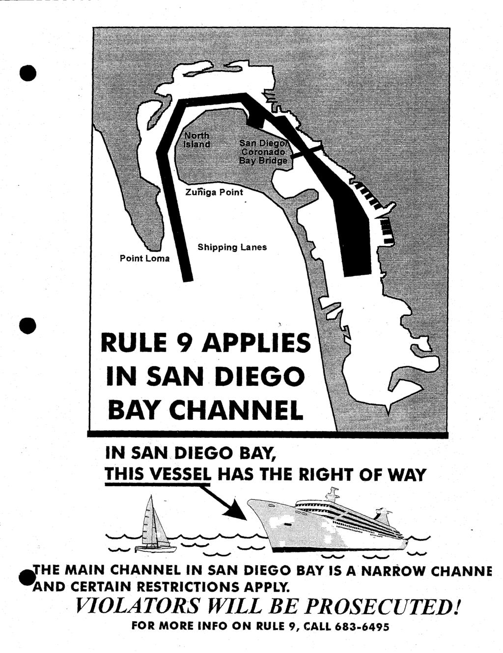
80


81 2006 Produced under a grant from the Dept. of Fish & Game s Office of Spill Prevention & Response. Layout: Rob Hughes 7,500 pieces 05/06 This pamphlet was created by the San Diego Harbor Safety Committee. For additional copies of this pamphlet, please contact: San Diego Baykeeper 2924 Emerson Street, Suite 220 San Diego, CA A Guide To Boater Safety San Diego Bay Sharing San Diego Bay Thousands of recreational boaters, huge ships, tugs, barges, ferries and other commercial vessels must share the use of the port of San Diego. This can be a challenge to all vessels using this extensive facility. Public awareness of the rules that commercial vessels operate under in our waterways can help provide recreational boaters with the best protection against navigational dangers within a port and save lives and property. This pamphlet is only a supplement to other recreational boater information on seamanship and the Rules of the Road. It makes the assumption that all recreational boaters know the rules and appropriate marine signals. For a refresher class in boating safety, contact the U. S. Coast Guard Auxiliary at SAIL, the U. S. Power Squadron at SEA-SKIL, Introduction to Boating at or the Coast Guard s Boating Safety hotline at Dangers Inside a Commercial Port Deep Draft Vessels and Coast Guard s Rule 9: Avoid ship channels. Rule 9 means that in a harbor channel, the ship has the right-of-way over small boats. That includes sail boats! Stay as far to the side as depth allows when a ship approaches. Avoid large ships and cross well behind them whenever possible. Don t put your life at risk by thinking a ship can get out of your way. Vessel speeds can be deceptive. So, don t take chances. Large Ship Dangers: Commercial vessels, including towboats, tugboats and ferries operate 365 days a year, 24 hours a day. The speed of a ship, towboat, or tugboat can be deceptive. A tow can travel one mile in seven minutes... and ships even faster. It generally takes up to a mile and a half for these vessels to stop. For example: If a water skier or windsurfer falls a thousand feet in front of a moving tug or tow, that person in the water has less than one minute to get out of the way of that vessel! Large vessels must maintain speed to steer safely and they must stay in the channel it s the only place deep enough for them to maneuver. Many channels are unmarked. Other channels extend bank to bank, so expect vessel traffic on any portion of the waterway. Wake and prop wash Submerged tow line Tugboat Dangers: When tugboats are towing or pushing barges, the danger of wheel wash is a regular occurrence in a port. Wheel wash is a strong underwater current caused by towboats or large vessel engines that creates a severe wake turbulence hundreds of yards behind these vessels. Never pass closely behind a tugboat or a large vessel. Under no circumstances ever pass between a tug and its tow! A tugboat without barges in front could be towing a barge or other objects on a long submerged line that s difficult to see. Never pass closely behind a tugboat and watch for barges or towed objects. Barges are not self-propelled! Visibility Dangers: A ship s blind spot can extend for hundreds of feet in front of deep-draft ships, tugboats and towboats pushing barges. Watch for ship, tugboat, towboat or ferry navigation lights at night. Do not rely on trying to hear a vessel approaching. Pay strict attention to the vessel sidelights. If you can see both sidelights (red and green), you re dead ahead, and directly in the path of danger! Use safe anchorages. Coast Guard navigational aids, such as buoys, mark channels for shipping. It is illegal and dangerous to tie to them. Each year commercial vessels ram and sink boats anchored in navigational channels or tied off to buoys. Naval & Cruise Ship Protection Zone: Do not approach within 100 yards of any U. S. Naval vessel. If you need to pass within 100 yards of a U. S. Naval vessel to ensure a safe passage in accordance with the Navigational Rules, you must contact the U. S. Naval vessel or the Coast Guard escort vessel on Channel 16. You must operate at minimum speed within 500 yards of any U.S. Naval vessel and proceed as directed by the Commanding Officer or the vessel patrol. Violations of the Naval and Cruise Ship Protection Zone are a felony offense, punishable by up to six years in prison and/or up to $250,000 in fines. Tips To Keep You Afloat: Maintain a vigilant lookout - Designate at least one person on your boat to watch out for commercial traffic. Both the Navigational Rules and common sense require this! Deploy a marine radar reflector - Use the reflector to increase your chance of detection by ships, especially in fog or at night Monitor your VHF radio on Channel 16 Understand whistle signals - Five or more short blasts on the whistle is the danger signal. Stay clear of vessels sounding this signal! Navigational gear - Always have the appropriate navigational gear (i.e., compass, charts, and GPS) for coastal waters, especially when cruising to offshore islands. GPS can enhance the Coast Guard and other rescue and assistance efforts to locate you in an emergency. Cell phones - cell telephone coverage offshore is unreliable. Do not depend on your cell phone for offshore emergencies. Local ordinances - Familiarize yourself with existing speed limits and other port ordinances. Never pass close ahead of large ships - Large ships often travel at greater speeds than your recreational craft. Also, they cannot stop or change course as readily. If your engine fails or you lose the wind, a large ship may not be able to avoid you. Never pass between a ship and the dock when the ship is docking. Do not anchor or loiter in shipping channels or in Pilot Boarding Areas. As far as possible, stay out of the Pilot Boarding Areas and minimize your time spent in the Precautionary Area outside the breakwater. Rules of the Road - Know and follow the Navigational Rules of the Road. Be aware that specific rules apply in the vicinity of large ships when operating in narrow channels and traffic separation lanes. L i n e of s i g h t B l i n d S p o t Weather - Listen to the NOAA Weather Radio broadcast. If the weather forcast is bad, don t go out. Keep Your Boat Safe Have safety equipment for your boat type and size: Lifejackets for every person on board. They must be U.S. Coast Guard approved and properly fitted. Working VHF, NOAA chart and fire extinguishers A man overboard retrieval plan If the most knowledgeable boater on board your vessel is hurt or overboard, who takes command? Protect your family - Take a Boating Safety Class! Always remember: Alcohol and boating are a deadly mix!


 Shelter Island North Island Naval Air Station San Diego International Airport Harbor Island Coast Guard")


82 San Diego Bay LOS ANGELES 125 mi. BNSF INTERSTATE 8 Riverside 100 mi. Using Your Marine Radio Every vessel in San Diego has a channel they are permitted to use by law. All recreational boaters must use the proper radio channel for routine and emergency communications. The prudent mariner uses the proper marine radio channel for their type of vessel and its activity. By using the correct radio channel all boaters help ensure the safety of their passengers, their vessels and the Bay. There are a number of VHF channels used by both ships and commercial interests associated with the Port of San Diego. These are as follows: Channel 16 - International Hailing & Distress Channel 13 - Commercial Vessel to Vessel Marine Radio Channel - 28 and 86 Working Channels - 61, 62, 63, 64, 68, 69, 70, 71, 72, & 78 Point Loma Shelter Island Harbor Is. North Island Point Loma Marine Corps Recruit Depot Liberty Station/Prominade Centre (Formerly Naval Training Center) Shelter Island North Island Naval Air Station San Diego International Airport Harbor Island Coast Guard Cruise Terminal/ B Street Pier Broadway Pier Port Administration INTERSTATE 5 San Diego U.S. Naval Supply Base Commander Naval Base San Diego BNSF STATE 163 Cold Storage Area Tenth Avenue Marine Terminal STATE 94 SD&IV INTERSTATE 15 PHOENIX 355 mi. INTERSTATE 805 If your VHF radio is out of service, the following emergency telephone numbers may be helpful: San Diego Coast Guard Sector Command Center - Joint: San Diego Harbor Police: Ballast Point Zuniga Point Ballast Point Zuniga Point Coronado Coronado San Diego Bay Bridge SD&IV BNSF Naval Station All spills must be reported to the following: - National Response Center and Terrorist Hotline: California State Warning Center: For Oil and Hazardous Waste Clean-up: CLEANUP - To report violations: Zuniga Jetty Bell Buoy Zuniga Jetty Naval Amphibious Base San Diego Bay National City National City Marine Terminal Hints on proper VHF radio etiquette: Set your radio to the low power setting Speak clearly and slowly Keep all communications brief Monitor Channel 16 while underway Switch to a common working channel to converse. When you have completed your conversation, switch back to Channel 16*. *Do Not Use Channel 16 for a radio check. Use Channel 09. Bell Buoy EMERGENCY RADIO CALL PROCEDURE 1. Ensure radio is turned on. 2. Select Channel 16 and switch to high power. 3. Press the transit button and clearly say: MAYDAY, MAYDAY, MAYDAY, THIS IS ; MY POSITION IS (GIVE YOUR CURRENT POSITION OR LOCATION AND DESCRIBE THE EMERGENCY); THERE ARE PERSONS ON BOARD. Warning, sending a false distress call is a violation of Federal law [14 U.S.C. 88(c)] and is punishable by fines and/or imprisonment. WEAR A LIFE JACKET! WEAR A LIFE JACKET! Traffic Separation Zone ft Marine Cargo Terminal Cruise Ship Terminal This map is not for navigational use. Keep an up to date navigation chart on board. Pacific Ocean Coronado Cays Channel Chula Vista Channel Coronado Cays Imperial Beach SD&IV Chula Vista Harbor INTERSTATE 5 Chula Vista SD&IV TIJUANA, MEXICO 5 mi.
83 Appendix D and E Unified Port of San Diego: (1) Vessel Port Calls (2) Fuel Barge Calls (3) Cargo (Tonnage) By Type (4) Fuel Cargo (Gallons) Appendix D&E Updated September 2015 San Diego Harbor Safety Plan, Approved 2015
84 Appendix D&E - Vessel Port Calls By Type, CY Containers Reefers Vessel Calls Dry Bulk Break Bulk Vehicles Lumber Sand Cruise Ships TOTAL 0 CY 2004 CY 2005 CY 2006 CY 2007 CY 2008 CY 2009 CY 2010 CY 2011 CY 2012 CY 2013 CY 2014 Source: Port of San Diego, 2015, Appendix D & E, San Diego Harbor Safety Plan Note: CY= Calendar Year Cargo Commodity
85 -2014 (By Calendar Year) Tonnages, Vessel Calls, Fuel Barge Vessel Containers Vehicles Break Bulk Dry Bulk TOTAL CY , , , , ,759, CY , , , , ,303, CY , , , , ,403, CY , , , , ,489, CY , , , , ,653, CY , , , , ,553, CY , , , , ,701, Note: CY Calendar Vessel Port Calls Containers Reefers Dry Bulk Break Bulk Vehicles Lumber Sand Cruise Ships TOTAL CY CY CY CY CY CY CY CY CY CY CY CY CY Note: CY Calendar Year Cargo Tonnages Fuel Barges / Barrels / Trip Calls Fuel Barges / Trip Calls
86 Barrels Trips CY , CY , CY CY , CY CY , CY CY , CY CY , CY CY CY , CY CY , CY , CY , Note: CY Calendar Year
87 Appendix D&E - Port Cargo Tonnages By Type of Cargo, CY ,800, ,600, ,400, ,200, Metric Tons 1,000, , , , , Containers Vehicles Break Bulk Dry Bulk TOTAL 0.00 CY 2010 CY 2011 CY 2012 CY 2013 CY 2014 Source: Port of San Diego, 2015, Appendix D & E, San Diego Harbor Safety Plan Note: CY= Calendar Year Calendar Years
88 Appendix D&E - Vessel Port Calls By Type, CY Containers Reefers Vessel Calls Dry Bulk Break Bulk Vehicles Lumber Sand Cruise Ships 0 CY 2004 CY 2005 CY 2006 CY 2007 CY 2008 CY 2009 CY 2010 CY 2011 CY 2012 CY 2013 CY 2014 Source: Port of San Diego, 2015 Appendix D & E, San Diego Harbor Safety Plan Note: CY= Calendar Year Cargo Commodity

89 Appendix D&E - Fuel Barge Port Calls, CY Fuel Barge Trips CY 2009 CY 2010 CY 2011 CY 2012 CY 2013 CY 2014 Calendar Year
90 Naval Ship Moves in San Diego Bay in Fiscal Year Fiscal Year = October through September Ship Moves = Homeported METRO ships Barge Moves = Barges Visiting Ships = Non-Homeported or Foreign ships SOURCE: U.S. Navy, 2015

91 Appendix D & E - Fuel Barge Barrels CY , , , , Barrels of Fuel 500, , , , , CY 2009 CY 2010 CY 2011 CY 2012 CY 2013 CY 2014 Calendar Year
92 Years Navy Fuel Depot Data for San Diego Bay Fiscal Years AOs (grey hulled tankers) Tankers (commercial tankers) JP5 BBLs Received/ Issue DFM BBLs Received/ Issue ,995,501 2,546, ,544,589 2,788, ,027,434 2,852, ,495,236 2,321, ,471,000 3,500, ,534,000 3,419, ,365,000 3,171, ,841,000 3,909, ,836,000 4,048, ,463,000 3,818, ,229,000 4,906, ,528,000 3,758, ,297,000 3,537, ,564,000 3,995, ,596,000 3,435, ,962,000 2,411, ,823,000 2,607, ,214,000 2,596, ,444,000 1,747, ,397,000 1,773, ,829,000 2,194, ,529,000 2,103,000 Years = Fiscal Year September to October AO= designation of grey hulled tankers Tankers = commercial tankers delivering product at the Navy facilities JP BBLs Received/issued = Jet propulsion fuel in barrels, received and issued DFM BBLs Received/issued = Diesel fuel in barrels, received and issued Revised June 2007 San Diego Harbor Safety Plan, Approved July 2007
93 Vessels Calling at Navy Fuel Depot in San Diego Bay Fiscal Years N u m b e r o f V e s s e l s AOs (grey hulled tankers) Source: US Navy, Fiscal Year September to October AO= designation of grey hulled tankers Tankers = commercial tankers delivering product at the Navy facilities JP BBLs Received/issued = Jet propulsion fuel in barrels, received and issued DFM BBLs Received/issued = Diesel fuel in barrels, received and issued Years

94 Barrels of Jet Fuel and Diesel Fuel Marine Received and Issued at Navy Fuel Depot in San Diego Bay Fiscal Years (Sept - Oct) B a r r e l s Years JP5 BBLs Received/ Issue DFM BBLs Received/ Issue Source: US Navy, Years Fiscal Year = September thru October AO = designation of grey hulled tankers Tankers = commercial tankers delivering product at the Navy facilities JP BBLs Received/issued = Jet propulsion fuel in barrels, received and issued DFM BBLs Received/issued = Diesel fuel marine in barrels, received and issued
95 Appendix H: San Diego Bay Allisions, Collisions, Groundings (By Calendar Year) Calendar Year Total Number * 5 Calendar Year = January to December * 2014 = data is thru 24 September 2014 Source: USCG Sector San Diego, Investigations Division, Total Number Total Number
96 CY 2005 Qtr 1 10 CY 2005 Qtr 2 9 CY 2005 Qtr 3 13 CY 2005 Qtr 4 2 CY 2005 Total 34

97 CY 2005 Collisions, Allisions, and Groundings USCG Sector San Diego Ports Series CY 2005 Qtr 1 CY 2005 Qtr 2 CY 2005 Qtr 3 CY 2005 Qtr 4
98 Appendix I Oil And Hazardous Substance Spills For San Diego Bay Appendix I Updated January 2015 San Diego Harbor Safety Plan, Approved January 28, 2015
99 APPENDIX I: USCG OIL AND HAZARDOUS SUBSTANCE SPILLS, BY INCIDENTS AND VOLUME, FOR SAN DIEGO BAY Pollution: Total Reported Pollution Incidents Total Incidents Unknown Source Total Incidents Source Identified Known Source Resulting from a Mystery N/A N/A N/A N/A N/A N/A N/A N/A N/A N/A N/A N/A N/A Total Potential Only Incidents N/A N/A N/A N/A N/A N/A N/A N/A N/A N/A N/A N/A Total Incidents Involving the Navy N/A N/A N/A N/A N/A Known Gallons Spilled by the Navy N/A N/A N/A N/A N/A N/A Total Reported Gallons Spilled Monthly Breakdown Mar Apr May Category: Jan Feb Jun Jul Aug Sep Oct Nov Dec # Spills: # Mystery: # Kown Source Gallons Spilled: Monthly Breakdown Mar Apr May Category: Jan Feb Jun Jul Aug Sep Oct Nov Dec # Spills: # Mystery: # Kown Source Gallons Spilled: Monthly Breakdown Mar Apr May Category: Jan Feb Jun Jul Aug Sep Oct Nov Dec # Spills: # Mystery: # Known Source: Gallons Spilled: Monthly Breakdown Mar Apr May Category: Jan Feb Jun Jul Aug Sep Oct Nov Dec # Spills: # Mystery: # Known Source: Gallons Spilled: Monthly Breakdown Mar Apr May Category: Jan Feb Jun Jul Aug Sep Oct Nov Dec # Spills: # Mystery: # Kown Source Gallons Spilled: Monthly Breakdown Mar Apr May Category: Jan Feb Jun Jul Aug Sep Oct Nov Dec # Spills: # Mystery: # Known Source: Gallons Spilled: Monthly Breakdown Mar Apr May Category: Jan Feb Jun Jul Aug Sep Oct Nov Dec # Spills: # Mystery: # Known Source: Gallons Spilled: Source: USCG Sector San Diego, Investigations Division, 2009
 The Unknown Navy spill Source data is for Total 1999-2008 Incidents only, Source no Identified data available Total for Incidents 1993-1998.")
100 Appendix I: Total Oil and Hazardous Substance Pollution Incidents # Incidents Calendar Year Total Note: Incidents (1) The Unknown Navy spill Source data is for Total Incidents only, Source no Identified data available Total for Incidents Involving the Navy Total Reported Pollution Incidents Source: USCG Sector San Diego, Investigations Division, 2009

101 Gallons Year Note: (1) The Navy spill data Known is for Gallons Spilled only, by no the data Navy available for Total Reported Gallons Spilled Source: USCG Sector San Diego, Invesigations Division, 2009
102 Appendix J San Diego Harbor Safety Committee Bylaws
103 SAN DIEGO HARBOR SAFETY COMMITTEE BYLAWS Article I: Name Section 1. The San Diego Harbor Safety Committee (hereinafter referred to as the Committee). Article II: Purpose Section 1. The Committee is established pursuant to Section of the Government Code and Title 14, California Code of Regulations, Sections ; and is responsible for planning for the safe navigation and operation of tankers, barges and other vessels within the harbor. The Committee shall prepare a Harbor Safety Plan encompassing all vessel traffic within the harbor. Article III: Membership Section 1. Members; Qualifications; Chairperson; Expenses (a) The Committee shall consist of members appointed by the Administrator of the Department of Oil Spill Prevention and Response (hereinafter referred to as the Administrator). Membership requirements are established by Section of the Government Code. (b) Any member completing a three-year term may apply to succeed himself. (c) The Chairperson of the Committee is appointed by the Administrator from the membership specified in Section of the Government Code. (d) Each member of the Committee shall be reimbursed for actual and necessary expenses incurred in the performance of Committee duties. (e) The Committee may petition the Administrator to designate up to five additional At-large membership categories that may be needed to conduct the Committee s business and to reflect the makeup of the local maritime community. The Committee may also petition the Administrator for the removal of any At-large membership category. The approval of such petitions shall be at the sole discretion of the Administrator. At-Large members shall include an excursion boat operator and a commercial fishing boat operator who shall have navigational expertise as defined in Section of the Government Code. The petition shall specify the requirements of the At- Large member position. (f) A member s appointment shall be terminated as a result of any of the following circumstances: (1) The member voluntarily resigns for any reason. (2) The member is removed by the Administrator for cause including: (i) Failure to meet attendance standards. (ii) Falsifying application materials Harbor Safety Plan Update - Approved January 28, 2015
104 (g) One alternate representative to each primary representative shall be appointed and sworn by the Administrator in the same manner as the primary representative and should be subject to the recommendation of the primary member. All applicants should be considered. (1.) The alternate shall be selected from the same membership category as the primary member and shall meet the same qualifications. (2.) The alternate may vote only in the absence of the primary member of that category. (3.) The alternate may continue to serve after the resignation or removal of the primary member until a new primary member is appointed and sworn. Alternate member may apply for primary member position. Harbor Safety Committee members appointed pursuant to Section , while performing their duties, shall be entitled to the same rights and immunities granted public employees. Those rights and immunities attach as of the date of appointment of the member to the Harbor Safety Committee. Section 2. Attendance (a) A representative from each category named in Section 1. (a) and (e) is expected to attend each regularly scheduled meeting of the San Diego Harbor Safety Committee. (b) In accordance with Section 1. (f) (2) (i), Failure to meet attendance standards, is grounds for a member s appointment to be terminated as follows: (1.) The primary member to miss 75% of meetings in a calendar year. (2.) The category, primary and alternate, to miss 50% of meetings in a calendar year. i. Primary member will make every effort to have alternate attend meetings in his/her absence. If neither can attend a meeting, notification of absence shall be made by the primary or alternate to the Chairperson or Secretariat. ii. Non-attendance by both primary and alternate to over 50% of meetings, with notice, will be addressed by the Chairperson, and action will be taken, as Chairperson deems necessary. (c) In all other circumstances regarding attendance, the Chairperson shall take action, as he/she deems necessary, and announce to the next full Committee meeting the action taken. Article IV: Officers Section 1. San Diego Harbor Safety Committee (a) Chairperson appointed by the Administrator from the membership specified in Article III. (b) Vice-chairperson appointed by the Administrator from the membership specified in Article III (only primary and at-large primary), and a different category than that of the Chairperson. (c) Executive Secretary (Secretariat) contracted by the Administrator to serve as administrative staff to the Committee Harbor Safety Plan Update - Approved January 28, 2015
105 Article V: Meetings Section 1. Meetings shall be duly noticed to members and alternates of the Committee and subcommittees and open to the public. (a) The Committee shall meet at least once per quarter at a location and time as designated by the Chairperson. (b) Meetings shall be conducted in accordance with Roberts Rules of Order, the Ralph M. Brown Act (Open Meetings for Local Legislative Bodies) and these bylaws. (c) A quorum consisting of a simple majority of voting members excluding federal agencies must be present in order that business can be legally transacted. Should a quorum not be present the Committee can proceed as a Committee of the whole, but cannot take action on any item. (d) The Committee may take action on an item not appearing on the agenda by determining that an immediate need exists and it came to the attention of the Committee after the agenda was distributed. This determination must be approved by a two-thirds (2/3 rd ) vote of all appointed Committee members or, if less than two-thirds (2/3 rd ) of all appointed members are in attendance, by a unanimous vote of those appointed members present. (e) An agenda shall be drafted by the Secretariat as directed by the Chairperson for each meeting and distributed to members, alternates and interested parties at least seven (7) days prior to the scheduled meeting. In accordance with the Brown Act, agendas for full Committee meetings shall be posted 72 hours in advance at the Secretariat s office and at the meeting location. Postings shall be visible from the outside of buildings. (f) Meeting minutes shall be taken by the Secretariat and published within ten days to all members, alternates and interested parties to permit any required action to be set in motion in a timely manner. Section 1. Article VI: Voting (a) Passage of any item subject to vote by Committee members shall require a simple majority of appointed members or their alternates present at the meeting. (b) Members shall recuse themselves from voting in case of potential conflict of interest. Article VII: Subcommittees and Work Groups Section 1. Establishment (a) The Committee may establish subcommittees and work groups as necessary. Subcommittee meetings shall be duly noticed and open to the public. (b) A subcommittee shall be composed of a chairperson appointed by the Chairperson of the San Diego Harbor Safety Committee and other members and alternates as appointed by the Subcommittee Chairperson to assist in forming recommendations for approval of the full Harbor Safety Committee. (c) A subcommittee in toto may or may not be called into session at any one time, but may also serve as a pool from which to form working groups. (d) Subcommittee and working group members shall have expertise contributing to the named purpose of the subcommittee and to the legitimate presentation of completed staff work for approval by the full Harbor Safety Committee Harbor Safety Plan Update - Approved January 28, 2015
106 (e) Members of subcommittees or working groups may be selected from the membership of the Harbor Safety Committee. Article VIII: Submissions from Committee Section 1. Harbor Safety Plan (a) The Committee shall prepare and submit the San Diego Harbor Safety Plan and annual updates to the Administrator by July 1 of each year or as directed otherwise by the Administrator. (b) The Committee shall make recommendations or requests to the Administrator as necessary regarding harbor safety, and may make recommendations or requests to other governmental agencies. Article IX: Bylaws Review, Acceptance and Amendments Section 1. Enactment of Bylaws (a) Must be included as an agenda item in a regular meeting of the San Diego Harbor Safety Committee. (b) Must be noticed in accordance with Article V: Meetings of these bylaws. (c) Must be approved by a majority of San Diego Harbor Safety Committee voting members in attendance. (d) Shall become effective upon Committee approval, and shall continue in force until amended or repealed. Section 2. Amendment of Bylaws The bylaws may be amended, repealed or re-enacted in whole or in part by a majority approval by the voting members of the Committee. Section 3. Bylaw Provision Disclaimer Should any provision of the bylaws be, or become, invalid, unenforceable, void, or prohibited by law or otherwise, the remaining provisions shall remain in full force and effect Harbor Safety Plan Update - Approved January 28, 2015
107 Appendix K List of Archive Items Appendix K Updated January 2015 San Diego Harbor Safety Plan, Approved January 28, 2015
108 ARCHIVES Archived Items may be accessed by contacting the Harbor Safety Committee Liaison for the Department of Fish & Game Office of Spill Prevention & Response Jack Prescott at 4949 Viewridge Ave. San Diego, CA Archive Item: 1. Tug Escort Regulations 2. Ballast Water Regulations 3. Non-Tanker Regulations 4. Oil Pollution Act of OSPR Compliance Review Report on Commercial Pilotage 7. History of Previous Harbor Safety Committee Recommendations Letter to California Dept. of Transportation regarding proposals to replace or repair the communication control system on the Coronado Bridge and other HSC recommendations regarding aids to navigation. 9. MOU State Lands and Fire Marshall 10. Draft MOU 1996 the State and C.G. regarding Pilotage Appendix K Updated January 2015 San Diego Harbor Safety Plan, Approved January 28, 2015
109 Appendix L Office of Spill Prevention and Response Strategy for Implementation of San Diego Harbor Safety Plan, February 14, 1996 Appendix L Updated January 2015 San Diego Harbor Safety Plan, Approved January 28, 2015
110 Appendix M San Diego Harbor Safety Plan Annual Review Dates and List of Changes SD HS Plan 2015 Update, Approved January 2015 M - 1
111 HARBOR SAFETY PLAN HISTORY VERSION DATE ADOPTED Final Adopted July 28, 1993 First Annual Review August 3, 1994 Second Annual Review June 21, 1995 Third Annual Review December 11, 1996 Fourth Annual Review November 12, 1997 Fifth Annual Review September 23, 1998 Sixth Annual Review May 26, 1999 Seventh Annual Review & Reformat November 29, 2000 Eighth Annual Review & Reformat June 30, 2001 Ninth Annual Review June 30, 2002 Tenth Annual Review June 30, 2003 Eleventh Annual Review June 30, 2004 Twelfth Annual Review June 30, 2005 Thirteenth Annual Review and Reformat June 30, 2006 Fourteenth Annual Review and Reformat June 30, 2007 Fifteenth Annual Review and Reformat June 30, 2008 Sixteenth Annual Review and Reformat June 30, 2009 Seventeenth Annual Review and Reformat June 30, 2013 Eighteenth Annual Review and Reformat January 28, 2015 SD HS Plan 2015 Update, Approved January 2015 M - 2
112 LIST OF CHANGES TO SAN DlEGO HARBOR SAFETY PLAN 2001 Annual Update and Review 1 Addition of page following Table of Contents containing information on new Naval Vessel Protection Zones and change in USCG Notification Requirements for vessels bound for or departing US ports. Changes are a result of increased port security measures in effect post-september 11, Update of membership roster for Pages Update of Appendix D, E, F, G, H, I, and J Annual Update and Review 1 Page 3 Section VIII, updated to read, "Vessel Traffic Service (VTS). Establishment of SDMIS for the Harbor Area." 2 Page 6 USCG information page updated (numbered to Page 6) 3 Page 7 Corrected Bill Lewis' address to read, "2091 Shelter Island Drive". 4 Page 8 Added alternate phone number to Corliss Nugent's listing, (858) Page 12 Under, "San Diego Bay and Area Charts:" corrected Chart #I8675 to read "#18772". 6 Page 19 After 2" Hazard, "San Diego Bay Channel Entrance, decreasing depths to shoreline." Added, "Aids to navigation are range markers at southern tip of Shelter Island shown in their 'as planned' position oriented to 353T for the inbound approach. The actual position is offset from 'as planned'. Refer to Local Notice to Mariners and to U.S. Coast Pilot 7." 7 Page 24 Under RADIO COMMUNICATIONS, 2ndparagraph, after 1'' sentence, added, "San Diego Marine Information System (SDMIS) is available at providing an interactive chart, a view of San Diego Bay, maritime information, winds, currents, tides, vessel schedules and site map." 8 Page 25 In line for channel 11, deleted "SeaTrac" and replaced with "Westcoast Marine". 9 Page 27 4 th paragraph, last sentence, changed, 24 th Street Terminal' to read, "National City Marine Terminal". Under "Commercial Vessels", 1'' paragraph, next to last sentence, corrected to read, "Cruise ships make regular calls at the Port's B Street Pier Cruise Ship Terminal." SD HS Plan 2015 Update, Approved January 2015 M - 3
113 Last paragraph, 2 nd sentence, deleted as redundant. 10 Page 28 Under LIMITED ACCESS AREAS, 3 rd paragraph, changed 2 nd sentence to read, Access to Restricted areas is limited to non-stop passage for the security of government property and/or to provide protection to the public from risks of damage." 11 Page 33 Under EVALUATION, 1 st paragraph, 2 nd line, changed, 24 th Street Terminal" to read, "National City Marine Terminal". 12 Page 34 3 rd line, corrected 1 st sentence to read, Five 2400 hp tractor tugs and one 4400 hp tractor tug are berthed at the Naval Station San Diego." 13 Page 35 Updated Escort Tug Inventory. 14 Page 36 Last paragraph, changed last sentence to read, "A web based system effect. The San Diego Marine lnformation System (SDMIS) is in place and operating. Web site is It provides an interactive chart, view of San Diego Bay, maritime information, winds, curents, tides, vessel schedules and site map." 15 Page 37 Under PROJECT FUNDING, San Diego Marine Information System (SDMIS) Project Funding, sentences 3 and 4, changed to read, "A web based information and operating system that provides real time marine information to a multitude of San Diego Bay users has been installed. The system includes electronic chart with point and click information overlays for port services, hazards, security zones, construction projects and marine events " 16- Page 38 Top of page, after, "transponder equipped vessels." Changed to read, "The OSPR has provided grant funds to the District " Delete last sentence of the paragraph. 17- Page 40 Recommendation 14, corrected "OPSR" to read, "OSPR. Recommendation 15, changed, "This recommendation is being fulfilled." To read, "Complete". Recommendation 16, changed as above to read. "Complete". 18 Pag41 Recommendation 23, second line, deleted "should" as being repetitious of sense of first line. 19 Page 47 Under PILOTAGE EVALUATION: 3 rd paragraph, line 2, changed "designation" to read, "authorization" SD HS Plan 2015 Update, Approved January 2015 M - 4
114 5 th paragraph, 1 st sentence, changed to read, "Four Authorized Pilots for the Port of San Diego I1 2" sentence, changed to read, "A fifth pilot is retired, but retains status as an 'Authorized Pilot'. 20 Update of Appendix D, E, F, G, H and I 2003 Annual Update and Review 1 Page 2 Under "The Process", first paragraph, 2"dsentence: corrected date of "update" to read correctly (May 28, 2003). 2 Page 7 Paragraph 2. Title: deleted "Commercial Fishing" 3 Page 8 Changed "West Coast Tug and Barge" to read, "Pacific Tugboat Service". Under "Alternate", added Phone: (61 9) , Fax: (61 9) Page 10 Paragraph I., United States Coast Guard, changed "LCDR" to "CDR". 5 Page 25 Changed "West Coast Tug & Barge" to "Pacific Tugboat Service" 6 Page 28 Under "LIMITED ACCESS AREAS", added reference to updated page 6 of the plan, "San Diego Area Security Zones" 7 Page 33 Changed "Tug Equipment" description to read... A minimum of seven commercial ship assist tugs assigned to San Diego Harbor are of the conventional twin-screw design. The available bollard pull ranges from 1,700 H.P. (22 t) to 3500 H.P. (34 t). The fleet has an average age of 27.7 years and average length of 83.7 ft. All of these tugs are outfitted with an operable tow winch fitted with wire(s) and all tugs are fendered for ship assist. These tugs perform both ocean and harbor service and are occasionally rotated between other ports. Some of the physical designs preclude their use in extreme flair and counter situations and in tight quarters. Thirteen other commercial tugs are regularly operated on San Diego Bay. The configuration of these tugs are primarily conventional push tugs and small conventional model bow tugs. Available bollard pull ranges from 450 H.P. (4 t) to 1250 H.P. (11 t). This fleet has an average age of 26.3 years and an average length of 45.9 ft. This fleet is used in a variety of applications including dead ship moves, barge moves, smaller ship assists, large ship assists in tight quarters, marine construction and general harbor and ocean towing. Five 2400 H.P. tractor tugs... 8 Page 35 Change "WEST COAST MARINE" to read "PACIFIC TUGBOAT.SERVICE SD HS Plan 2015 Update, Approved January 2015 M - 5
115 9 - Page 38 Paragraph at top of page, delete last sentence. No longer needed. Last paragraph, 2 nd sentence, deleted as redundant. 10 Page 28 Under LIMITED ACCESS AREAS, 3 rd paragraph, changed 2 nd sentence to read, Access to Restricted areas is limited to non-stop passage for the security of government property and/or to provide protection to the public from risks of damage." 11 Page 33 Under EVALUATION, 1 st paragraph, 2 nd line, changed, 24 th Street Terminal" to read, "National City Marine Terminal". 12 Page 34 3 rd line, corrected 1 st sentence to read, Five 2400 hp tractor tugs and one 4400 hp tractor tug are berthed at the Naval Station San Diego." 13 Page 35 Updated Escort Tug Inventory. 14 Page 36 Last paragraph, changed last sentence to read, "A web based system effect. The San Diego Marine lnformation System (SDMIS) is in place and operating. Web site is It provides an interactive chart, view of San Diego Bay, maritime information, winds, curents, tides, vessel schedules and site map." 15 Page 37 Under PROJECT FUNDING, San Diego Marine Information System (SDMIS) Project Funding, sentences 3 and 4, changed to read, "A web based information and operating system that provides real time marine information to a multitude of San Diego Bay users has been installed. The system includes electronic chart with point and click information overlays for port services, hazards, security zones, construction projects and marine events " 16- Page 38 Top of page, after, "transponder equipped vessels." Changed to read, "The OSPR has provided grant funds to the District " Delete last sentence of the paragraph. 17- Page 40 Recommendation 14, corrected "OPSR" to read, "OSPR. Recommendation 15, changed, "This recommendation is being fulfilled." To read, "Complete". Recommendation 16, changed as above to read. "Complete". 18 Pag41 Recommendation 23, second line, deleted "should" as being repetitious of sense of first line. 19 Page 47 Under PILOTAGE EVALUATION: SD HS Plan 2015 Update, Approved January 2015 M - 6
116 3 rd paragraph, line 2, changed "designation" to read, "authorization" 5 th paragraph, 1 st sentence, changed to read, "Four Authorized Pilots for the Port of San Diego I1 2" sentence, changed to read, "A fifth pilot is retired, but retains status as an 'Authorized Pilot'. 20 Update of Appendix D, E, F, G, H and I 2003 Annual Update and Review 1 Page 2 Under "The Process", first paragraph, 2"dsentence: corrected date of "update" to read correctly (May 28, 2003). 2 Page 7 Paragraph 2. Title: deleted "Commercial Fishing" 3 Page 8 Changed "West Coast Tug and Barge" to read, "Pacific Tugboat Service". Under "Alternate", added Phone: (61 9) , Fax: (61 9) Page 10 Paragraph I., United States Coast Guard, changed "LCDR" to "CDR". 5 Page 25 Changed "West Coast Tug & Barge" to "Pacific Tugboat Service" 6 Page 28 Under "LIMITED ACCESS AREAS", added reference to updated page 6 of the plan, "San Diego Area Security Zones" 7 Page 33 Changed "Tug Equipment" description to read... A minimum of seven commercial ship assist tugs assigned to San Diego Harbor are of the conventional twin-screw design. The available bollard pull ranges from 1,700 H.P. (22 t) to 3500 H.P. (34 t). The fleet has an average age of 27.7 years and average length of 83.7 ft. All of these tugs are outfitted with an operable tow winch fitted with wire(s) and all tugs are fendered for ship assist. These tugs perform both ocean and harbor service and are occasionally rotated between other ports. Some of the physical designs preclude their use in extreme flair and counter situations and in tight quarters. Thirteen other commercial tugs are regularly operated on San Diego Bay. The configuration of these tugs are primarily conventional push tugs and small conventional model bow tugs. Available bollard pull ranges from 450 H.P. (4 t) to 1250 H.P. (11 t). This fleet has an average age of 26.3 years and an average length of 45.9 ft. This fleet is used in a variety of applications including dead ship moves, barge moves, smaller ship assists, large ship assists in tight quarters, marine construction and general harbor and ocean towing. Five 2400 H.P. tractor tugs... 8 Page 35 Change "WEST COAST MARINE" to read "PACIFIC TUGBOAT SD HS Plan 2015 Update, Approved January 2015 M - 7
117 SERVICE. 9 Page 38 Paragraph at top of page, delete last sentence. No longer needed. 10 -Pages 41 to 43 The Port of San Diego Pilots Association should review Recommendations 20. Through 27 as to applicability and make recommendation to the Navigation Safety and Piloting Subcommittee in the premises. These recommendations can remain in the Plan as stated, but some have been overtaken by events and should be modified or eliminated to reflect reality. Further, items requiring funding should be identified with the suggested source of funding. 11- Page 47 Last paragraph, line 7, the sentence was partially corrected, but turned out not making sense. The intent was to designate those deep draft ships that required "intensive" power supplies. As written recommend delete "intensive" between words "deep draft" and "ships" 12-Page 48 Under "PIPELINES" ---line 4: The fuel storage tanks of the former SDG&E facility at National City have been demolished. Remediation of the soil at the former tank farm currently is in progress. The pipeline from the former tank farm to the National City Marine Terminal vessel berths has been abandoned as follows. The pipeline has been "pigged" to remove any fuel product. The valves and fill connections of the pipeline have been removed from the vaults at the vessel berths and the pipeline has been sealed off, in a gas-free condition, and inerted with nitrogen. The pipeline is approximately 4' below grade. 13 -Page 33. Recommendation 16A, Section VII, second paragraph. That one is very old and was completed a few years back. It was a change to the Tug Regulations, which did get made -in So that can go. There are three recommendations that OSPR did take some kind of action, #8 on, #I4 on page 40, and #20 on page #4I. 14- Page 39 #8 requests that we get the DMV to continue to send out their flyers on boating laws. This is no longer necessary; DMV sends out with every new registration, a 26-page pamphlet called the ABC'S of California Boating Laws. 15 -Page 40 #I4 asks OSPR to require rental agencies to require boat renters to read the rules of the road and boating under the influence regulations prior to execution of the rental agreement. OSPR doesn't have the legal authority to do that. However, the Department of Boating and Waterways considers boat rentals to be under their purview, but considers that the proposed requirement is not an enforceable law or regulation. The Deputy Director of Boating and Waterways is willing to come to a meeting SD HS Plan 2015 Update, Approved January 2015 M - 8
118 and discuss what agencies can handle what issues and talk about their educational outreach program. The recommendation should be deleted. 16 -Page 41 The third recommendation, #20, concerns state pilotage, requesting OSPR to consider covering San Diego under State Pilotage Regulations The California Harbors and Navigation Code, sections through 1203, detail how to go about incorporate the SD Pilots, establishing a local pilotage board, define the area of operation, what vessels are subject to pilotage, training criteria and so on in great depth. However, in 1997, OSPR did complete an MOU signed by the ports of Long Beach, LA, Port Hueneme and San Diego, that details the initial competency and qualifications of pilots, standards for maintaining proficiency and professional growth, enforcement, the local pilotage advisory council. There is no state license for private pilot organizations. So if incorporation is not an option, the MOU is as far as OSPR is able to go on pilotage issues. The pilotage recommendations in the plan may be moot points. This should probably be discussed by the subcommittee and then the whole committee. I can distribute copies of the MOU to whoever would need them. The Harbors and Navigation Code is at Update of Appendix D, E, F and G 2004 Chanqes to the SD Harbor Safetv Plan Paqe Number 2 Under "The Process", change to "this plan was updated Sept 2004 and represents..." 5 Emergency Response Procedures, Add: Report Suspicious Activity: Pollution Reporting Incidents including Oil Spills -National Response Center and Terrorist Hotline San Diego Coast Guard Sector Command Center -Joint Add "The Navy has installed Physical Protection Barriers to protect its assets at 32 nd Street Naval Station, the Aircraft Carrier Basin and the Submarine Base." - Add June 29, 2004 Memo Titled: "Implementation of International Ship & Port Facility Security Code and Regulated Navigation Area" San Diego Harbor Safety Committee Membership Updates -See 2004 Roster SD HS Plan 2015 Update, Approved January 2015 M - 9
119 35 Updated Tug Inventory Chart 38 Delete last sentence of first paragraph "As of September 2000, the District is preparing a Request for Proposals to Develop and install the SDMIS". 49 Appendix -Add: P -Tug Escort Regulations Q -San Diego Harbor Safety Committee Bylaws R -San Diego Coast Guard Sector Command Center -Joint Add Appendices P -Tug Escort Regulations Q -San Diego Harbor Safety Committee Bylaws R -San Diego Coast Guard Sector Command Center -Joint 2005 Changes to the SD Harbor Safety Plan Page Number 6 Delete Notification of Arrival in US Ports section San Diego Harbor Safety Committee Membership Updates 11 Remove "...encompasses 12,000 acres and is 14 miles long and, at half-tide, has an area of 18 square miles and a water volume of 300 million cubic yards" from the second paragraph, first sentence. Moved to first paragraph, second sentence. -Use acronym SDB for "San Diego Bay" -Updated phone number for Environmental Health Coalition to (61 9) Last contact listing, change 'Supercomputer Oil-Spill Modeling' to "Project" 1 Update San Diego Bay and Area Charts: Add #I8765, Submarine Safety Lanes 20 Under: Anchorages for General Use, first paragraph "...between the mouth of Sweetwater Channel and a point on the southerlv shore of Crown Cove on the Silver Strand". Second paragraph "...South San Diego Bay is generally prohibited except for vessels engaqed in fishinq durinq daylight hours and permitted vessels in UPD requlated anchorages. Authorization to anchor in North or Central San Diego Bay outside designated anchorage areas, for limited periods of not more than 72 hours, may be obtained by application to the Chief of Police. Harbor Police Department." 21 Update Contact Phone Number: Contact Phone Number: Port of San Diego, Marine Operations (61 9) Change "A minimum of seven (change to four) commercial ship assist tugs..." 34 Under STEERING AND STOPPING EFFECTIVENESS OF TUGS, third paragraph: Delete "A more accurate assessment is by "bollard pull" testing. Such testing is conducted by connecting a tug to a shore side dynamic measuring device and applying SD HS Plan 2015 Update, Approved January 2015 M - 10
120 full tug's power in both the ahead and astern modes. The tugs push/pull capability is indicated by the measuring device in a designated measurement standard." -Under TUG MANNING, last word, change two to three. 35 Updated Tug Inventory Chart Appendix 0 Updated LIST OF CHANGES TO SAN DIEGO HARBOR SAFETY PLAN 2006 Changes to Harbor Safety Plan Updated the text, facts, and figures in all the Chapters throughout the Plan.. Updated, reorganized, and re-titled the Appendices. Added a new Appendix O: - Maritime Information: Federal, State and Local Agency Websites. Deleted the following Appendices: - Resources for Emergency Response Environmental Clean-up, Firefighting, and Salvage (was Appendix B): out of date - USCG WAMS Report (was Appendix J): out of date - OSPR Outreach Program 1995 (was Appendix L): out of date 2007 Changes to Harbor Safety Plan Updated the text, facts, and figures in all the Chapters throughout the Plan. Reformated and streamlined the Plan Chapters to make the Plan easier to read and a little more consitent with layout of the other HSC plans. Updated, reorganized, and re-titled the Appendices. Added a new Appendix O: Added a map of the SD Harbor Safety Planning Area on Page 2 of the Plan Changes to Harbor Safety Plan Updated the text, facts and figures in all the Chapters throughout the Plan. Updated, reorganized and re-titled the Appendices. The HSC voted to remove reference to the Encina Marine terminal in text and Appendix J because the Harbor Safety Plan does not include operational aspects of the terminal. Added a section on Best Maritime Practices at the direction of OSPR management. Removed the table of reportable quantities on the Emergency Response Procedures page. Reportable quantities differ between hazardous materials and oil spills. SD HS Plan 2015 Update, Approved January 2015 M - 11
121 Status update change was made on the CalPORTS accomplishment and recommendation section 2009 Changes to Harbor Safety Plan A. Maritime Security - MTSA, TWIC (Page vi and 32) Summary Paragraph referencing MTSA, TWIC was added to the BMP#1 - Important General Information Section. See page vi. The four new detailed paragraphs, written by Mark Taylor and now revised by Mike Dolan (USCG), have been moved to the Chapter VI, Vessel Traffic Patterns - Federal, State and Local Laws, page 32. (Seemed logical place.) B. BMP #2 - Pre-Arrival Guidelines (page vi) LCDR Mike Dolan made revisions to NOA and Port Tariff paragraphs to address Capt Marks request for clarity about whether Pre-Arrival check-in applies to Yachts, and what the procedure is. See BMP section, page vi. C. Inland Navigation Rules (page viii and 32) Per suggestion/request from Sterling Stires, a short paragraph referencing Inland Navigation Rules apply to San Diego Bay and Mission Bay was added to the BMP #6 Recreational, Naval, and Commercial Vessel Interaction. See page viii. Per Sterling, similar paragraph was added to Chapter VI Federal, State, and Local Laws. See page 8. Per Sterling, similar paragraph was added to Chapter VI Federal, State, and Local Laws. See page 32. D. USCG Updates to Limited Access Areas (Page 26,27) U.S. Navy Security Zones, Restricted Areas, and Naval Vessel Protection Zones (page 26). LCDR Mike Dolan updated text. Security Zone around Coronado Bay Bridge (page 27). LCDR Mike Dolan updated text E. XII Enforcement (page 39) I made changes made to 2 nd paragraph (i.e., US Coast Guard has primary authority ) based on my notes that said to clarify navigable waters. Is my revision okay or should the text be left as was? F. Recommendations and Accomplishments (pages 41, 42, 43) LCDR Mike Dolan, USCG updated Nav. Safety Recommendation #4 with one more new sentence at end. (page 41) Deleted Boater Education Recommendation 13: Publicize the availability and list of insurance agencies who offer discounts on insurance rates to those boaters who graduate from approved Safe Boating classes. (page 42) Deleted Accomplishments # 4. Relocated Buoy SD1 approximately one mile east placing it in line with the entrance range and 5. Installed additional gated pair entrance Buoys. Eliminate Buoy 3. (page 43) G. Maintenance Dredging For Safe Navigation (page 12) 2 deletions per 3/25 mtg. H. Action Summary On Aids To Navigation (page 14) addition per USCG SD HS Plan 2015 Update, Approved January 2015 M - 12
122 I. Recreational Boating (page 24) addition per Capt Marks J. Two new maps added HS Plan region and SD Bay Harbor (page 2 and 3) and Data tables/ charts are all updated (pages 23, 25,30, 31, 36) 2015 Changes to Harbor Safety Plan Under contacts my needs to be updated to: Jack.Prescott@wildlife.ca.gov & the phone changed to my cell number: Back to the top of the page under the Harbor Safety Plan bullet click the link & it goes to the plan that is dated as All the dates need to reflect 2014 since the end of May on the cover page & in the footers. Reference to page numbers is in the PDF viewer numbering, the plan page number is in ( ). Section VI. Vessel Traffic Patterns Commercial Vessels top of page 36 (25) the cruise ship calls need to reflect for Summary of Vessel Traffic & Cargo page 37 (26) has incorrect Figure reference of Figure 2 it should be Figure 3. The traffic forecast should be updated also. Figure 3: Port of San Diego Vessel Port Calls: needs updating since 2009 on page 36 (25) along with the supporting statements on vessel activity in the paragraph above it also references Appendix D & E for additional data last updated Figure 4: Port of San Diego Average Annual Vessel Traffic: page 38 (27) data needs updating: Port of San Diego Average Annual Vessel Traffic Page 42 (31) Accident And Near Accidents, Accidents and Pollution Incidents :reference to Appendix H & I last update Requested updated info from USCG Figure 5: Collisions, Allsions, and Groundings in San Diego Bay : page 43 (32) data needs updating Requested updated info from USCG Statement at bottom of page 43 (32) referencing Figure 6: Oil & Hazardous Substance Incidents in San Diego Bay needs updating: Suggest pairing down the number of years to last 5 with new data from USCG. Requested updated info from USCG Figure 6: : Oil & Hazardous Substance Incidents in San Diego Bay page 44 (33) pair down to last 5 years. Requested updated info from USCG Figure 7: Gallons of Oil & Hazardous Substance Spilled in San Diego Bay 44 (33) pair down to last 5 years. Requested updated info from USCG Update link page 45 (34) Federal, State, And Local Laws to VII. TUG ASSIST/ESCORT update link to Figure 8: 2008 Escort Tug Inventory San Diego Bay page 47 (36)needs updating remove Foss Tugs & update Crowley tugs the Edision Chouest Offshore tugs info is good. SD HS Plan 2015 Update, Approved January 2015 M - 13
123 Appendix N Maritime Information Federal, State, and Local Agency Websites
124 Links to California Maritime Information Websites General San Diego Maritime Information links San Diego Marine Information System (SDMIS) (Interactive charts, winds, currents, links to other agencies) Coast Guard San Diego Sector Ports Operations Information for Safety and Efficiency (POISE) US Coast Guard Sector San Diego U.S. Coast Guard Local Notice to Mariners, District 11 NOAA Nautical Charts San Diego Unified Port District Recreational Boating Information Boating Rules and Regulations _rules_page/index.asp Harbor Police Bay Services General Links Government Agencies California Boating and Waterways California Office of Spill Prevention and Response 2 January 2015 Harbor Safety Plan Update
125 Regulations: Tug Escort, Harbor Safety Committees, Oil Spill Prevention and Response Plans, Financial Liability California Harbor Safety Committees (San Diego, LA/LB, Port Hueneme, San Francisco, Humboldt): Harbor Safety Plans, Bylaws, Meeting Dates and Minutes, Governing Regulations and Statutes, etc. California Department of Fish and Game California State Lands Commission Ballast Water Program and Regulations Webpage llast_water_default.htm Marine Facilities Division Regulations California Coastal Commission U.S. Coast Guard Home Port Page (note: no "www") click on "Port Directory" choose "San Diego" on the pull down menu see all things related to USCG San Diego U. S. Navy Pacific Fleet 3 January 2015 Harbor Safety Plan Update
126 Miscellaneous Marine Exchange of Southern California San Francisco Marine Exchange US Coast Guard San Diego Area Contingency Plan (note: no "www") click on "Port Directory" choose "San Diego" on the pull down menu find "Safety And Security" on the page Click on Area Contingency Plan 4 January 2015 Harbor Safety Plan Update
; LTJG Colleen Patton Approved by: D11 (dpw); Mr.")
127 WATERWAY ANALYSIS AND MANAGEMENT SYSTEM (WAMS) REPORT SAN DIEGO BAY - FEDERAL CHANNEL (Waterway 83771; WAMS D11 ID # 10) PREPARED: June 2015 by: USCG SECTOR SAN DIEGO WATERWAYS MANAGEMENT DIVISION Written by: LCDR John Bannon Reviewed by: LCDR Kris Szczechowicz Reviewed by: D11 (dpw-wams); LTJG Colleen Patton Approved by: D11 (dpw); Mr. Mike VanHouten next due:
128 TABLE OF CONTENTS Section Title Page Title/Signature Page 1 Table of Contents 2 I. Executive Summary 3 II Information Collection 4 A. Narrative Description B. Users III Waterway Research and Information 11 A. Public Comments B. Casualty History C. Traffic Patterns D. Key Changes Since 2007 E. Thru J.: ATON information K. Chart Alterations L. NOAA review IV Criticality Determination 15 V Study Results / Analysis Findings 16 VI Report Recommendations 17 VII Points of Contact 19 VII Enclosures 1. Casualty Data 2. Local Notice to Mariners Advertisement 3. Criticality Worksheet(s) 4. Survey Report (n=35) 20 2
129 I. EXECUTIVE SUMMARY 1. The last San Diego Bay Federal Channel WAMS study was done in The 2014 WAMS study covers changes and data review from 2007 to The study began July 2013 and completed May The study was due in 2012 (five year review period) and is three years behind. The long research period and delay of the report is not a factor in any navigation hazards or degradation to the waterway, but due to unit staffing changes and priority of projects. The next report will be due Upon a waterway review, the Aids (45+ key aids) supporting the San Diego Bay Federal Channel are deemed adequate, appropriate and sufficient. There are no pressing concerns nor any marine casualties attributed to the Aids. Recommendations are listed on Page 19. Rule Nine remains the top Navigation concern for the channel, followed by Naval Vessel Protection Zone infractions. Information from this report was shared with the San Diego Harbor Safety Committee in May Furthermore, San Diego Bay does not utilize a Vessel Traffic Service or Marine Traffic Center. Naval Port Operations and Coast Guard/Harbor Police jointly monitor traffic. Transit time for deep drafts from beginning to end of channel is about 1.5 to 2.5 hours. 3. Federal channel is 12 miles long and includes 12+ commercial mid/large size mooring areas, three commercial terminals, and two main anchorage areas for deep draft vessels. The Channel includes four main areas: Approach Channel (miles 0 to 2); Entrance Channel (miles 2 to 4); North San Diego Bay (miles 4 to 8; above Coronado Bridge); South San Diego Bay (miles 8 to 12; below Coronado Bridge). 4. For criticality determination, The San Diego Bay Federal Channel is determined to be: a. Military Critical. The U.S. Navy Third Fleet resides in San Diego Bay. The Naval Fleet includes nuclear and conventional submarines, nuclear carriers, and a variety of (20+) carriers, destroyers and other combat ships. There are thousands of Naval and Coast Guard transits in or out of the Bay annually. The San Diego Bay Federal Channel is determined not to be: b. Navigation Critical. Channel use includes a variety of military and commercial vessels. Despite the traffic, it is not considered Navigation Critical (see Enclosure (2)) as scored in two separate evaluation systems. The complexity of traffic, review of the depth/width of the channel, weather and commerce were all factored. During calculations, the added total of the points was 111, four below the minimum to designate as navigationally critical. But it is very close and borderline Navigation Critical; very much worth monitoring. c. Environmentally Critical. A change from the 2007 WAMS study. Upon closer examination of hazardous cargo (Soda Ash, Potash, Bauxite; and not reflecting deep draft fuel tanks) transiting the Federal channel, San Diego Bay is relatively free of Hazmat shipments, unlike other D11 major ports. A score of 25 was given the waterway. A score of 35 or higher is determined to be Environmentally Critical. Environmental damage relating to oil spills would be significant on local economy and protected areas/environmental sensitive areas, but not critical. 3
130 II. INFORMATION COLLECTION A. NARRATIVE DESCRIPTION (1) 2007 San Diego Federal Channel WAMS report, summary: (a) The last WAMS report was submitted in It captured data from Casualty data from Port of San Diego provided information on Marine Casualties in San Diego. Majority of the accidents were in 2006 (41%), followed by 2005 (27%) and finally 2004 (32%). Out of the five categories of casualties capsizing was (07%), personal injury at (07%), flooding and sinking (07%), Collision (59%), and collision with injury at (20%). The information given did not give specific vessel statistics or locations (i.e. in or outside the channel?). (b) The previous report did not include any recommended changes except for the comment stating It is recommended that the Zuñiga Jetty be further reviewed for the upcoming San Diego Bay WAMS Report. Many items of concern for the waterways outside the federal channel will be addressed in the San Diego Bay WAMS Study (2015). (c) The waterway in 2007 was determined to be military and environmentally critical, but not navigation critical. Our 2015 report concurs with the 2007 report, with the exception that we recommend changing the environmentally critical determination to non-critical. (2) CHARTS. All charts for San Diego Bay Federal Channel were found to be geographically correct. (a) The smallest scale chart is the San Diego Bay is NOAA chart #18773, SAN DIEGO BAY, 43rd edition. It has a scale of 1:12,000 and was last updated by the Defense Mapping Agency or NOAA May (b) The next largest scale chart is the San Diego Bay is NOAA chart #18772, APPROACHES TO SAN DIEGO BAY, 48th edition. It has a scale of 1:20,000 and was last updated by the Defense Mapping Agency December (c) San Diego Bay also appears on NOAA chart #18765, APPROACHES TO SAN DIEGO AND MISSION BAY, 17th edition. This chart has a scale of 1:100,000 and was last updated by the Defense Mapping Agency November (d) San Diego Bay also appears on NOAA chart #18740, SAN DIEGO TO SANTA ROSA ISLAND, 44th edition. This chart has a scale of 1:234,270 and was last updated by the Defense Mapping Agency July
131 (3) GEOGRAPHIC FEATURES: (a) Channel Overview: San Diego Bay Federal Channel is the only entrance into San Diego Bay. San Diego Bay is a natural harbor. However, the Bay does require routine dredging by the Army Corp of Engineers (ACE). The bay is 14 miles long, and the federal channel is 12 miles long. Point Loma on the west side of the entrance to San Diego Bay is a ridged peninsula with a max height of 400 feet. Thick kelp beds extend from the west open ocean side to more than 1.5 miles around to the south to Ballast Point on the east side. Along the channel, good visual and radar returns exist, even with the fog and thick marine layer clouds. The Channel is also well marked with aids to show the dredged limits for deep draft vessels, which is well centered until reaching the Coronado Bridge. In clear weather the skyline of the city of San Diego is very prominent upon approach. Other shoreside prominent visual markers exist. At night, there is prominent back scatter city lights. (b) The Approach Channel begins with the Sea Buoy, a Safe Water Mark. Point Loma Light at the southern tip is 88 feet above the water. As you enter the Entrance Channel from the Approach Channel, the federal channel Range Light becomes visible. (c) The Entrance Channel to San Diego Bay is between Point Loma to the west and Zuniga Jetty to the east. The Entrance Channel was dredged to a width of 800 feet to mile 2.4, narrowing to 600 feet at mile 3.0 and continuing at that width to the Carrier Turning Basin adjacent to the north side of Coronado. Point Loma is marked by a single light house at the seaward end, and Zuniga Jetty has a north and south extension. Through this congested narrowing which includes Naval fuel and ammo piers, submarine base, bait barges and high concentration of recreational sailing and all size power craft, is a well needed gated pair to mark the limits of the protected Channel. In addition, Naval, Coast Guard, Customs and Border Patrol, and Harbor Police LE boats have a strong presence in the area. The Zuniga jetty has a light and fog signal at the seaward end, helping small to medium sized vessels find the Channel from the East. A total of five lights run the submerged jetty to the end of the northern extension. Inside the entrance are lit gated buoys and a front and rear range guiding transit of the San Diego Bay Approach Channel. Ballast Point, low and sandy, projects 0.4 mile northeast from the east side of Point Loma, 1.3 miles north from Point Loma Light. Ballast Point Light, 16 feet above the water, is shown from a dolphin with a green and white diamond-shaped day mark off the end of the point; the light has a sound signal. Three piers of the Naval Submarine Base are just north of Ballast Point. (d) The North Bay Channel includes off of Shelter and Harbor Island, and Coronado. The Carrier turning basin is dredged to 42 feet. Much of the Small Passenger Vessels (T-boats) transit to and from this portion of the channel/waterway. (e) The Central Bay Channel has a depth of 40 feet between mile 7.1 and The Central Bay includes the cruise ship terminals (2 piers) and main Embarcadero, including Small Passenger Vessels (K-boats) (Flagship and Hornblower) and the 5
132 San Diego Maritime Museum. The Central and South Bay are separated by the only bridge, the Coronado Bridge. Central Bay also has the Tenth Avenue Marine Terminal, available for container cargo and bulk/break bulk, as well if needed, car (RO-RO) use. (f) The South Bay Channel is authorized to a depth of 35 feet between miles 8.84 and just past mile 11. The South Bay Channel hugs the East Side, while the west side is shallow and provides for entrance to Glorietta Bay and Naval Base Coronado. Along the east side is BAE Systems and General Dynamics NASSCO shipyards, and Naval Base San Diego. The South Bay dredged portion of the Federal Channel ends at 24 th Street Terminal (National City Marine Terminal), a major destination for car carriers, lumber barges and Military Outloads. There is a pier face for RO- ROs in the Sweetwater Channel. (g) Ship Channel dredging: A Federal project provides for a dredged channel with depths of 47 feet in the entrance and through North San Diego Bay to the turning basin on the NE side of North Island (near Pier K), thence 42 feet to just NW of the San Diego-Coronado Bay bridge, thence 37 feet to a basin SW of the National City Marine Terminal. With a width of 800 to 600 ; the Navy deepened the outer and inner entrance channels to a depth of -55 Mean Lower Low Water (MLLW) and -47 MLLW respectively. Army Corp of Engineers recently funded the dredging of the Approach and Entrance Channels (2012). There are no other currently planned dredging projects for (h) Facilities: B Street Pier Cruise Ship Terminal, Broadway Pier, Tenth Avenue Marine Terminal (Berths 1 thru 8), and National City Marine Terminal (Berths 24-1 thru 24-4 and and 24-11). The San Diego Unified Port District owns the deep draft commercial facilities in the bay and operates them either independently or in conjunction with private firms. The port piers and wharves have water, rail, and highway connections. There are a number of smaller privately operated wharves and piers used for receiving oil, repairing vessels, and for mooring and fueling small crafts (which are covered in greater depth in the San Diego Bay WAMS report). (i) Marinas: Numerous marinas are located adjacent to the Federal Channel. There are also launch ramps (4), boat yards (3), fishing piers (4) and fuel docks (3); (again, covered in greater depth in the San Diego Bay WAMS report). (j) Industry: The Port serves as a transshipment facility for the region. The year-round mild climate is conducive to handling all types of cargo, such as containers, dry bulk, liquid bulk, refrigerated, vehicle, break bulk, and project cargo. The Port s three marine cargo facilities are Tenth Avenue Marine Terminal, National City Marine Terminal, and the Broadway/B Street Cruise Ship Terminals. Cars Lumber Potash Windmill parts Cruise ship Military Sand Cement Bananas Bauxite Pineapples 6
133 (4) BRIDGES: (a) The Coronado Bridge is the only bridge spanning the Federal Channel of San Diego Bay. The 2.1 mile bridge span reaches a maximum height of 200 feet, allowing the U.S. Navy ships and car carriers which operate out of the nearby Naval Station San Diego and National City Marine Terminal to pass underneath it (including an empty draft aircraft carrier). (5) ANCHORAGES: (a) Inner Bay: There are eight inner smaller vessel anchorages administered by the Port of San Diego (SD Mooring Company) adjacent to the federal channel within San Diego Bay. (b) There are six military anchorage for Navy vessels within San Diego Bay just off of Harbor Island (33 CFR ), and more than 30 outside of San Diego Bay that the Navy administers. (c) There is one commercial anchorage area (33 CFR ) for temporary, awaiting berth commercial, generally deep draft vessels or large mega-yachts, where multiple vessels could fit. (6) ENVIRONMENTAL FACTORS: B. USERS (a) The currents set generally in the direction of the channels. In the vicinity of the entrance the usual velocity varies from a half to 5 knots depending upon the stage of the tide. In the San Diego Bay area, visibility is reduced to less than a half mile, mostly by radiation fog about 3 to 7 days per month from September through April. December is the foggiest month. This fog is worst during the late night and early morning hours. Temperatures are moderate. The average high is 71 F and the average low, 57 F. August is the warmest month with an average temperature of 72.2 F. Precipitation is light and falls, on average, only 70 days each year. Winds in the area are strongest from March through September, when they blow 17 knots or more about two percent of the time. (1) VESSELS: (a) San Diego Bay is utilized significantly by small sailing, pleasure craft, commercial fishing and passenger carriers, personal watercrafts and paddlecrafts. This includes sport fishing, whale watching and diving operations. The larger vessels are container ships, and multi deck car carriers. San Diego Naval Base is the principal homeport of the Pacific Fleet, consisting of 54 ships, 3 main base locations and over 120 tenant commands. (b) There are 3 tug, tow and barge companies/groups, led by Crowley, Pacific and USN 7
134 tractor tugs. There are no more Foss Tugs in San Diego. (c) There are approximately 10+ sailing clubs. Regattas are common year-round. Often regattas use channel aids as part of their courses. (d) For fishing, there are roughly 175 T-boats, several K-boats, thousands of uninspected passenger vessels, and 365 commercial fishing vessels working out of San Diego. (e) There are several Ferry boats that operate between the Embarcadero and Coronado. (f) There are numerous military small boats operating in San Diego Bay. (g) There is one sea plane operator, who largely operates in South Bay out of the Channel. (2) PILOT AND PROFESSIONAL GROUPS: (a) A Port of San Diego pilot group represents San Diego Bay. There are 3 pilots. They will soon add a part-time 4 th pilot. (b) USN Pilots utilize three tractor tugs, and assist mainly with docking operations. (c) The most prevalent professional organization is the Sportfishing Association of California (SAC) which is made up of commercial and commercial for hire fishing boat owners and operators. (3) PORT AUTHORITIES: (a) The San Diego Bay Unified Port District is the port authority within San Diego Bay. The Port is governed by a seven-member Board of Port Commissioners; one commissioner each is appointed by the city councils of Chula Vista, Coronado, Imperial Beach and National City, and three commissioners are appointed by the San Diego City Council. The Harbor is served by the Harbor Unit of the Police Department. Sworn police officers and supervisors provide marine and land-based law enforcement services to residents, visitors, and boaters 24 hours a day. Harbor Unit officers are trained in emergency medical procedures, CPR, dive rescue and salvage, boating rescues, and fire fighting. (b) Port of San Diego is the fourth largest of the 11 ports in California, and includes the cities Chula Vista, Coronado, Imperial Beach, National City and San Diego. The port oversees two maritime cargo terminals, two cruise ship terminals, 20 public parks, the Harbor Police Department and the leases of hundreds of tenant and sub tenant businesses around San Diego Bay. The Port of San Diego is an economic engine, an environmental steward of San Diego Bay and the surrounding tidelands, and a provider of community services and public safety. (c) San Diego Bay Harbor Police operates from the headquarters building across from 8
135 their airport. The Harbor Unit currently operates a fleet of three Crystaliner rescue boats and a 35 ft Safe boat, and two firestorm fire boats. In order to accommodate boating visitors to San Diego Bay, the San Diego Unified Port District maintains a public access Guest Dock facility at the Harbor Police Sub Station, 1401 Shelter Island Drive, San Diego. The station is located on the southern end of Shelter Island at the entrance to the Shelter Island Yacht Basin. The facility has 26-slips; it can host recreational vessels up to 65-feet in length which can stay for periods of up to 15 days, within a 40 day period. This station also acts as CBP customs check-in dock where vessels can call in to CBP to be inspected on a designated 24 hour phone. CBP has a variety of high speed law enforcement vessels. (4) HARBOR MARINE INTERESTS: (a) There are ten yacht clubs in the bay with a governing body called the San Diego Association of Yacht Clubs. The following are the San Diego Bay participating clubs: California Yacht Club, Chula Vista Yacht Club, Coronado Cays Yacht Club, Coronado Yacht Club, Navy Yacht Club San Diego, San Diego Yacht Club, Silver Gate Yacht Club, Southwestern Yacht Club, Cortez Racing Association, and Point Loma Yacht Club. (b) Fuel piers: There are five commercial fuel docks in San Diego Harbor, all of them are in the northern part of the bay in Shelter and Harbor Islands. Shelter Island has Pearson s Fuel Services, High Seas Fuel Dock, and Shelter Island Fuel Dock. Harbor Island has Harbor Island West Fuel Dock and Cortez Fuel Dock. The military has a fuel pier at Point Loma, across and north east of the Bravo Ammo Pier, located on North Island. Currently the military fuel pier is under construction to increase size and modernize. In 2013, the security zone around the fuel pier was increased to meet the longer pier into the waterway. (c) Repair Yards: There are between five and 10 different sized yards located throughout the bay. Marine Group, General Dynamics NASSCO, and BAE are the leading ones for larger vessels; others are located in the small harbors of San Diego Bay. (5) DEPARTMENT OF DEFENSE: UNITED STATES NAVY (a) Naval Base San Diego, sometimes referred to as 32 nd Street Naval Station, is the largest United States Naval base on the west coast and is the principal homeport of the Pacific Fleet, consisting of 54 ships and over 120 tenant commands. The base is composed of 13 piers stretched over 977 acres of land and 326 acres of water. (b) Point Loma Naval Base includes Commander Third Fleet, Naval Mine and Anti Submarine Warfare Command, Space and Naval Warfare Systems Command, and Submarine Squadron Eleven and a Coast Guard Detachment. Title 33, Code of Federal Regulations (CFR), Section (San Diego Harbor, CA naval 9
136 restricted area adjacent to Point Loma) and 33 CFR (Pacific Ocean off Point Loma, CA naval restricted area). (c) Naval Amphibious Base (NAB) Coronado is home to a major Navy shore command, supporting over 30 tenant commands, and is the West Coast focal point for special and expeditionary warfare training and operations. (6) The Army Corps of Engineers (ACOE) Los Angeles Office performs maintenance dredging of the San Diego Harbor Channel. The only dredge work that the ACOE has performed at San Diego Harbor in the past five years is the San Diego Harbor Entrance Channel from Nov 8 th to Dec 22 nd, All work was seaward of Ballast Point. The Entrance Channel has a design depth of -55 ft at Mean Low Low Water (MLLW), and any high spots shallower than -55 ft were dredged. They removed 441,000 cubic yards of material from the channel. Annually, the ACOE performs hydrographic surveys of the harbor. (7) U.S. Customs and Border Protection use the San Diego Bay for law enforcement patrols and customs inspections. III. WATERWAY RESEARCH AND INFORMATION A. PUBLIC COMMENT (1) Public comment for this report update was solicited via an ELEVENTH COAST GUARD DISTRICT LOCAL NOTICE TO MARINERS (LNM), Enclosure (2). (1) Online Survey: Link given in LNMs. (2) Survey groups. Interviews conducted with members of Harbor Safety Committee. (3) Interviews of key operators included Port Pilots, and an inbound car carrier transit (December 2014) to review night to morning aids. B. CASUALTY HISTORY (1) Coast Guard MISLE data for San Diego Bay has been compiled in a spread sheet. There were 23 incidents directly relating to navigation. (2) Eleventh District Recreational Boating Safety representative shared information on Recreational boating incidents from None of the information pertained to aids to navigation issues. Specifically, there were no incidents located in San Diego Federal Channel. C. TRAFFIC PATTERNS (1) San Diego Bay is home to various types of vessels. The Navy s Pacific Fleet houses 10
137 over fifty vessels. The channel has a very simple Lateral Traffic Scheme that follows the basic red-right-returning system of the International Association of Lighthouse Authorities (IALA) B Maritime Buoyage System. (2) The bay has many regulated no wake zones, safety zones, and security zones. The weather is a factor during fog situations or when heavy winds frequent the bay during various times of the year. The width and dredge depth is sufficient for the type of vessels transiting the bay. (3) There are no barge lanes. Lumber and fuel barges are not in excessive amounts. Weekly trips to San Clemente Island and refueling within the Bay do occur for barge traffic. D. KEY AID CHANGES SINCE 2007 (1) Disestablished San Diego Bay Channel Lighted Buoy 41 (LLNR 2050). This Aid was removed due to not deemed necessary, around (2) Upgraded all lighted buoys to LED. (3) SD Safe Water Mark was temporarily lost in D11 dpw added virtual eaton MMSI. E. AID ASSIGNMENT LIST Table 1 is a listing of federal aids to navigation in San Diego Bay Channel. These aids are listed in geographical order, as you would pass them when navigating through the approach channel to the south bay. Aid Name SD Bay App. LWB SD SD Bay App. LB3 SD Bay App. LB 4 SD Bay Channel LB 5 SD Bay Channel LB 6 SD Bay Channel LB 7 Light List # 10 (1485) Sound Signal Whistle Light or Color White FL MO (A) 1490 None Green FL 6s 1493 Bell Red FL Q 1495 None Green FL 2.5s 1510 None Red FL 4s 1515 None Green FL 4s Note RACON reestablished Hull/ Daymark 8 x 26 Red & White Safe H20 Mark 8 x 26 Green 8 x 26 Red 8 x 26 Green 8 x 26 Red 8 x 26 Green Primary Unit USCGC GEORGE COBB USCGC GEORGE COBB USCGC GEORGE COBB USCGC GEORGE COBB USCGC GEORGE COBB USCGC GEORGE COBB 11
138 SD Bay Channel LB 8 SD Bay Channel LB 9 SD Bay Channel LB 10 SD Bay Channel LB 11 SD Bay Channel LB 12 Ballast Point Light B SD Bay Channel LB 14 SD Bay Channel LB 15 SD Bay Channel LB 16 SD Bay Channel LB 16A SD Bay Channel LB 17 SD Bay Channel LB 18 SD Bay Channel LB 19 SD Bay Channel LB 20 SD Bay Channel LB 21 SD Bay Channel LB 22 SD Bay Channel LB 22A 1545 None Red FL 2.5s 1550 None Green FL 2.5s 1555 None Red FL 4s 1560 None Green FL 4s 1565 None Red FL 2.5s 1570 Horn White FL 4s 1585 None Red FL Q 1590 None Green FL 2.5s 1620 None Red FL 2.5s 1625 None Red FL Q 1630 None Green FL 4s 1645 None Red FL 4s 1650 None Green FL Q 1710 None Red FL Q 1715 None Green FL Q 1830 None Red FL 4s Assist subs coming in/out of channel Marks kink in channel Perhaps move more outboard? 1825 None None Good one to try to downsize 8 x 26 Red 8 x 26 Green 8 x 26 Red 8 x 26 Green 8 x 26 Red 16FT Tower 6 x 20 Red 7 x 17 Green 7 x 17 Red 6 x 20 Red 6 x 20 Green 6 x 20 Red 6 x 20 Green 6 x 20 Red 6 x 20 Green 6 x 20 Red Class 2 Nun Red USCGC GEORGE COBB USCGC GEORGE COBB USCGC GEORGE COBB USCGC GEORGE COBB USCGC GEORGE COBB ANT SAN DIEGO USCGC GEORGE COBB USCGC GEORGE COBB USCGC GEORGE COBB USCGC GEORGE COBB USCGC GEORGE COBB USCGC GEORGE COBB USCGC GEORGE COBB USCGC GEORGE COBB USCGC GEORGE COBB USCGC GEORGE COBB USCGC GEORGE COBB SD Bay Channel LB 23 SD Bay Channel LB 24 SD Bay Channel LB None Green FL 4s 1840 None Red FL 4s 1845 None Red FL 4s Outside the Channel; marks shoals. 6 x 20 Green 5 x 11 Red 5 x 11 Red USCGC GEORGE COBB USCGC GEORGE COBB USCGC GEORGE COBB 12
139 SD Bay Channel LB 26A SD Bay Channel LB 28 SD Bay Channel LB 30 SD Bay Channel LB 32 SD Bay Channel LB 33 SD Bay Channel LB 34 SD Bay Channel LB 36 SD Bay Channel LB 38 SD Bay Channel LB 39 SD Bay Channel LB None Red FL 6s 1980 None Red FL 4s 2005 None Red FL 4s 2010 None Red FL 4s 2015 None Green FL 2.5s 2020 None Red FL 2.5s 2035 None Red FL 4s 2040 None Red FL 2.5s 2042 None Green FL Q None Red FL 4s Good one to try to downsize Marks wreck. Good one to trial downsize Good one to trial downsize Good one to trial downsize 5 x 11 Red 5 x 11 Red 5 x 11 Red 5 x 11 Red 5 x 11 Green 5 x 11 Red 5 x 11 Red 5 x 11 Red 5 x 11 Green 5 x 11 Red USCGC GEORGE COBB USCGC GEORGE COBB USCGC GEORGE COBB USCGC GEORGE COBB USCGC GEORGE COBB USCGC GEORGE COBB USCGC GEORGE COBB USCGC GEORGE COBB USCGC GEORGE COBB USCGC GEORGE COBB F. MINOR AIDS. The Minor Aids serving San Diego Bay were reviewed by Coast Guard D11 dpw, GEORGE COBB and/or ANT San Diego in accordance with required ATON tasking. All of the aids meet or exceed the type, color, naming convention and spacing requirements. All lit aids were upgraded to LED. G. MAJOR AIDS (A major light has nominal range of 10 nm; shore aid) Aid Name Point Loma Light (1891) Entrance Range Front Light Light List # Sound Signal Light or Color Hull/Daymark Primary Unit 5 Horn White 88FT Tower ANT SAN 1bl ev 30 Fog signal DIEGO sec 22 nm (detected) 1500 Horn Green 28 ft tower (range ANT SAN FL Q 8-10 miles). LED. DIEGO 1 blast ev 10s (1s bl) Activated by USCG Entrance Rear Light Range 1505 None Green FL6s MRAAS conversion 56 ft tower (range 8-10 miles). LED ANT SAN DIEGO H. ELECTRONIC AIDS 13
140 eaton Virtual (briefly Virtual & Synthetic SD Buoy Pier B Street Sound Signal Zuniga Light Z Point Light Signal Jetty Loma Fog Light List # Sound Signal Light or Color Hull/Daymark MMSI Primary Unit (whistle) Satellite 8x26 Safe Water D11(dpw) Mark. For echarting, 9 MMSI is Cruise Ships 1 blast ev ANT SAN 15 sec (2s DIEGO Bl) 1800 Horn Activated upon request 1520 Horn Continuously. 1 bl ev 10 sec (1 s bl) 5 Horn 1bl ev 30 sec White FL 2.5s White 22 nm MRASS conversion Support to boaters entering from east entrance to channel Note: Discrepant. Operating back up Light. Structure safety concerns to fix. 28FT Tower Lighthouse 88 ft. ANT SAN DIEGO ANT San Diego VLB 44.LED I. PATON Aid Name Light List # Sound Light or Color Hull/Daymark Primary Unit Signal SD Coronado Bay 1860 Horn (2). 1 N/A None CALTRANS Bridge Fog Signal bl ev 10s (1s bl) San Diego 1861 None None None CALTRANS Coronado Bay Bridge RACON C San Diego 1859 None None None CALTRANS Coronado Bay Bridge RACON T Tenth Avenue N 1850 None FG 10ft POSD Berth Light Tenth Avenue S 1855 None FG 10ft POSD Berth Light WR 32A 2014 None QR? PATON; marks wreck (outside of channel) Navy Lighted Mooring Ball 1720 None White FL 4s Class 2 WU USN; just outside of channel Nat l City Berth 2025 None Fixed Green None POSD 14
141 Light Light J. SERVICING UNITS. The primary ATON servicing unit in San Diego Bay is Coast Guard Cutter GEORGE COBB and the Coast Guard Aids to Navigation Team (ANT) San Diego. K. CHART ALTERATIONS/CORRECTIONS. No chart corrections are recommended at this time. L. REVIEW OF NOAA (1) Coast Pilot. a. Current edition is Volume 7, 47 th Edition (2015). b. Information has been verified to be correct and accurate. SSD initiated six recommendations to NOAA for correcting Coast Pilot in the Pilotage section of San Diego bay entry to update outdated information. There were also some minor grammar corrections in the San Diego Bay section and Pilot information changes. Changes completed and updated. (2) 2015 Coast Guard Light List. Volume VI Light List is accurate. IV. CRITICALITY DETERMINATION (1) For criticality determination, The San Diego Bay Federal Channel is determined to be: a. Military Critical. The U.S. Navy Third Fleet resides in San Diego Bay. The Naval Fleet includes nuclear and conventional submarines, nuclear carriers, and a variety of (20+) carriers, destroyers and other combat ships. There are thousands of Naval and Coast Guard transits in or out of the Bay annually. The San Diego Bay Federal Channel is determined not to be: b. Navigation Critical. Channel use includes a variety of military and commercial vessels. Despite the traffic, it is not considered Navigation Critical (see Enclosures (2)) as scored in two separate evaluation systems. The complexity of traffic, review of the depth/width of the channel, weather and commerce were all factored. During calculations, the added total of the points was 111. ***Note: This is four below the minimum to designate as navigationally critical. But it is very close and borderline Navigation Critical; very much worth monitoring. San Diego Bay Federal Channel is not a complex, challenging channel. It does get busy and Navigation Rule 9 does come into play. Traffic density for deep draft, type of cargo, general area, number and type of aids allows the recommendation to not list it as Navigation Critical. c. Environmentally Critical. A change from the 2007 WAMS study. In 2007, listed it as Environmentally Critical. Upon closer examination of limited hazardous cargo (Soda Ash, Potash, Bauxite; and not reflecting deep draft fuel tanks) transiting the Federal channel, San Diego Bay is relatively free of Hazmat 15
142 shipments, unlike other D11 major ports. A score of 25 was given to the waterway. A score of 35 or higher is determined to be Environmentally Critical. *** Note: Environmental damage relating to oil spills would be significant on local economy and protected areas/environmental sensitive areas. But the mechanism to determine Environmentally Critical factors in much more than just vessel oil spill concerns. (2) Completed worksheets covered in Enclosure (3). V. ANALYSIS FINDINGS A. Key Findings. (1) SD Federal Channel WAMS addresses channel aids and those aids used in addition to navigate (Point Loma Lighthouse; certain aids just off of the channel). All other aids beyond the channel within San Diego Bay will be covered in a separate San Diego Bay (Small Harbor/Waterway) WAMS. (2) After a thorough review of all aids supporting the San Diego Bay Federal Channel (day/night transits; review of key documents, data collection) and discussion with key stakeholders and associations, all aids found to be adequate in sound and visibility, necessary, properly used, and helpful to the Mariner. No new aids are recommended. (3) There were no major corrections to NOAA charts, Coast Pilot, or Coast Guard Light List referring to federal channel aids (several Light List/Chart corrections were done for tertiary aids to be removed). Coast Pilot was updated to reflect changes in the San Diego Bay Piloting Association. (4) During the time the SD Buoy (Safe Water Mark) was off station (sunk) from April to August 2014, a virtual synthetic eaton was successfully established. Several mariners (including Coast Guard cutters) could not see the AIS on their electronic charting. When the SD Buoy was recovered and another hull placed on scene, the RACON was not initially reestablished, but subsequently was. (5) No significant trends were found from the Survey findings. (6) No significant trends were found from the Marine Casualty data review (Enclosure (1)). (7) San Diego Bay Pilot Association has three pilots. They are in the process of hiring a fourth pilot as they anticipate greater RO-RO, general cargo and car carrier port calls in coming years, and address increasing age of current three pilots and/or emergencies. (8) Army Corp of Engineers dredged the Approach and Entrance Channels, November 2012 to January (9) Three to five car carriers a week (PASHA, 24 th Street Terminal) are offloaded in San Diego, one in every eight new cars coming into the U.S. Weekly container traffic 16
143 (Dole) at the Tenth Avenue Marine Terminal brings in the majority of west coast bananas and avocados. Breakdown by cargo type is dry bulk (50%) and break bulk (10%), containers (20%) and vehicles (15%), and liquid bulk (5%) cargo. Maritime commerce was estimated in 2013 with bringing into the Port of San Diego $457 million. Port vessel calls are projected to decrease from FY15 to FY16 (-5; ), then steadily increases in FY17 (469) to FY20 (496). (10) There are on average 25 permitted marine events that affect and/or cross the Federal channel. There are also another 25 that are in close proximity but not permitted by the Coast Guard, as they are not determined to increase the hazards on the waterway. Large events include the two December Parade of Lights that involve 250 decorated recreational boats crossing the Federal channel on a Sunday evening for 2-3 hrs. The Big Bay Boom fireworks marine event involves 5 fireworks barges in and/or adjacent to the federal channel. Both events are well coordinated with USN and commercial traffic by Coast Guard planning. (11) In the past two years, the Coronado Bridge RACON has been intermittently working. This PATON is owned and operated by the California Transportation Division (CALTRANS). (12) Channel Range lights Recently the rear range was solarized. Solar power had issues in summer 2014, so increasing batteries and getting a new solar calc. With LED, viewing from 8 NM or more is not as easy, especially if slightly east of course (Pilots). (13) There is an increase in recreational (kayakers/sailboats) impacting the federal channel, as are commercial fishing vessels setting traps in the channel. (14) Pier B Sound Signal (LLNR 1800) system has too much static causing it to go off frequently, day or night (USN transmissions leading cause). Recommend MRAAS as soon as possible. Same with Entrance Range Front Light (LLNR 1500) and Ballast Point Light B (LLNR 1570). (15) There are no recommendations to changing ATON from lit to unlit, or vice-versa; or to enav. VI. RECOMMENDATIONS (1) No immediate or urgent SSD, ANT San Diego or D11 dpw action required in regards to the San Diego Bay Federal Channel aids to navigation. (2) Recommend reclassifying San Diego Bay Federal Channel (or San Diego Bay) as Not Environmentally Critical, due to WAMS scoring not meeting required score, and lack of large scale hazardous cargo transiting the waterway. This is a change from the 2007 report. (3) Support MRRAS conversion of San Diego Pier B sound signal. We ve been waiting for available equipment since Pier B Sound Signal (LLNR 1800) system has too much static causing it to go off frequently, day or night (USN transmissions leading 17
144 cause). Recommend MRAAS as soon as possible. Same with Entrance Range Front Light (LLNR 1500) and Ballast Point Light B (LLNR 1570). (4) Maintain SD Buoy (Safe Water Mark). Complete a formal survey later on. As per ATON listening sessions in 2014, aid was considered by large and small boating community as a key aid (even if not mandated; Safe Water Marks). (5) Continue to support FY16 CEU funding for the repair of the 100-year old Point Loma Light. A SSMR is in place for repair of the tower/footing, at an estimated cost of $1 million. Multiple options are being evaluated currently. Eleventh District (dpw) POC. (6) The keeping of Eleventh District (dpw) support for FY16 CEU funding also is recommended for tower maintenance to: Zuniga LT W (LLNR 11535) and SD Bay Entrance Range Front LT tower (LLNR 1500). *Note: 2 others on the list, outside of SD Bay: Oceanside Breakwater LT 1 (LLNR 2295) and Mission Bay North Jetty LT 1 (LLNR 2280). All on FY16 funding, to start in FY16. (7) Downsizing Buoys 33 and 22A is recommended in FY16. Buoy 33 marks shoal to the Marine Group Boat Yard and Tenth Avenue Marine Terminal. Buoy 22A, which is just outside the Federal Channel, marks the shoals off of Coronado. ANT San Diego can easily work both aids if downsized from 5x11 to 5 th Class Foam. (8) If Recommendation 7 is executed, and after a suitable review period, perhaps the downsizing of 22A, 26A, 33, 39, and 40 from 5x11 to 5 th class Foam (remain lighted) could be explored. This would allow ANT San Diego to work on those aids; but now able to be worked by ANT vs. COBB, thus saving resources/costs. The result would allow ANT San Diego to work all afloat aids in South San Diego Bay. (9) Recommend Eleventh District hires a Civilian position in Waterways Management at Sector San Diego. For Sector San Diego, a LT and MST1/MST3 limits sufficient waterway expertise, consistency or enough professionalism for the maintenance of history and customer service due to the changing of petty officers annually and the potential for LT billet to be TDY, on LV, or gapped if advanced. 18
145 VII. POINTS OF CONTACT Coast Guard Sector San Diego Waterways Management Division Attn: Division Chief 2710 North Harbor Drive San Diego, CA Officer in Charge Coast Guard Aids to Navigation Team Attn: Officer in Charge 2710 North Harbor Drive San Diego, CA Port of San Diego Marine Terminal Superintendent & Wharfingers Maritime Operations Maritime Division (619) (619) San Diego Harbor Police Department 3380 North Harbor Drive San Diego, CA Office: (619) Work Cell: (619) Shelter Island Drive San Diego Ca Harbor Safety Committee (led by Port of San Diego/CA OSPR) USCGC GEORGE COBB (WLM 564) Attn: Commanding Officer San Pedro, Calif Onshore: Offshore: Mobile: Paul Patricio CNRSW Waterfront Ops PM & Harbormaster; USN 3 rd Fleet; including POC for USN Pilots. Office: (619) San Diego Bay Pilots Association San Diego Bay Pilots Association Inc. Tenth Avenue Marine Terminal 626 Switzer St. San Diego, CA Office / dispatch Office fax or Sportfishing Association of California (SAC) calsportfishing@gmail.com North Harbor Drive Suite 100 San Diego CA Pasha: NCMT (Cars) Dole: Bananas/Fruit NASSCO BAE 19
146 VIII. ENCLOSURES Enclosure (1) Marine Casualty Data directly related to Federal Channel. (a) Marine Casualty Data from MISLE 2007 to 2012 Waterway Name Date Latitude Longitude San Diego Bay: North Island Naval Air Station San Diego Bay: North Island Naval Air Station: Museum USS REAGAN Submarine N 32 43' 00.00" W ' 00.00" N 32 42' 29.00" W ' 42.00" San Diego Harbor N 32 43' 09.00" W ' 37.00" San Diego Harbor N 32 40' 50.00" W ' Channel Entrance: 58.00" Naval Base Point Loma: Buoys 11 & 12 San Diego Bay: North Island Naval Air Station: Bait Barge San Diego Harbor: Coronado Island: Navy's Carrier Basin N 32 42' 33.00" San Diego Harbor: Tom Hams Lighthouse Restaurant: 500 Yds South N 32 43' 12.00" San Diego Harbor: Buoy 20 San Diego Harbor: Tenth Avenue Marine Terminal San Diego Bay: North Island Naval Air Station: Lighted Channel Buoy 16 N 32 42' 07.00" N 32 41' 47.00" W ' 03.00" W ' 00.00" W ' 42.00" N 32 43' 00.00" W ' 15.00" N 32 41' 43.00" W ' 09.00" Length (ft.) 52 0 Breadth (ft.) 30 0 Event Type Allision Event Class Broadside Allision Head-on Allision Broadside Groundin g Outside marked channel Collision Special Circumstances Allision Head-on Boat 1 Boat 2 Boat 1 Boat 2 Collision Overtaking 26' 0.0 Capsize Overwhelmed by Sea and/or Wind Allision Astern W ' 45.00" Allision Astern 20

147 Enclosure (2) Local Notice to Mariners Advertisement 21

. 22")
148 Enclosure (3) WAMS Criticality Worksheet and D11 Criticality Worksheet (2 documents). 22
149 23

150 Enclosure (4) Survey Results. Hard copy with Sector San Diego. 61 pages D11 dpw has a copy 24
The LA/LB Harbors handle more than 5,500 commercial vessel arrivals per year (excluding local coastwise and Catalina Island traffic).
.") X. SMALL CRAFT For the purpose of the Los Angeles and Long Beach Harbor Safety Plan, pleasure vessels, commercial fishing vessels and sportfishing boats are designated as small craft. A. BACKGROUND: The
X. SMALL CRAFT For the purpose of the Los Angeles and Long Beach Harbor Safety Plan, pleasure vessels, commercial fishing vessels and sportfishing boats are designated as small craft. A. BACKGROUND: The
HELSINKI COMMISSION HELCOM SAFE NAV 4/2014 Group of Experts on Safety of Navigation Fourth Meeting Helsinki, Finland, 4 February 2014
 HELSINKI COMMISSION HELCOM SAFE NAV 4/2014 Group of Experts on Safety of Navigation Fourth Meeting Helsinki, Finland, 4 February 2014 Agenda Item 3 Accidents and ship traffic in the Baltic Sea Document
WORK-REST REQUIREMENTS FOR PILOTS
 AN ORDER OF THE BOARD OF PILOT COMMISSIONERS FOR THE PORT OF CORPUS CHRISTI AUTHORITY REGARDING WORK-REST REQUIREMENTS FOR PILOTS AND COMBINED BEAM RESTRICTION Whereas, the current Rules and Regulations
World Shipping Council. National Oceanographic and Atmospheric Administration
 Comments of the World Shipping Council Submitted to the National Oceanographic and Atmospheric Administration In the matter of Endangered and Threatened Species; Petition for Rulemaking to Establish a
GENERAL LIMITATIONS AND RESTRICTIONS. LNGC Temporary Exemption (Effective August 21, 2018)
") RULES AND REGULATIONS GOVERNING PILOTS AND PILOTAGE ON THE CORPUS CHRISTI SHIP CHANNEL EFFECTIVE AUGUST 1, 2013 AMENDED EFFECTIVE MAY 13, 2014 AMENDED EFFECTIVE OCTOBER 1, 2014 AMENDED EFFECTIVE JANUARY
RULES AND REGULATIONS GOVERNING PILOTS AND PILOTAGE ON THE CORPUS CHRISTI SHIP CHANNEL EFFECTIVE AUGUST 1, 2013 AMENDED EFFECTIVE MAY 13, 2014 AMENDED EFFECTIVE OCTOBER 1, 2014 AMENDED EFFECTIVE JANUARY
BookletChart. Intracoastal Waterway Matecumbe to Grassy Key NOAA Chart A reduced-scale NOAA nautical chart for small boaters
 BookletChart Intracoastal Waterway Matecumbe to Grassy Key NOAA Chart 11449 A reduced-scale NOAA nautical chart for small boaters When possible, use the full-size NOAA chart for navigation. Published by
LOCAL NOTICE TO MARINERS
 USCG Notice to Mariners 3/7/18 (View full Notice here) LNM 10/18 Coast Guard District 1: U.S. Department of Homeland Security United States Coast Guard LOCAL NOTICE TO MARINERS COASTAL WATERS FROM EASTPORT,
GENERAL LIMITATIONS AND RESTRICTIONS. Draft Restrictions
 RULES AND REGULATIONS GOVERNING PILOTS AND PILOTAGE ON THE CORPUS CHRISTI SHIP CHANNEL EFFECTIVE AUGUST 1, 2013 AMENDED EFFECTIVE MAY 13, 2014 AMENDED EFFECTIVE OCTOBER 1, 2014 I GENERAL The Rules and
MAC Transit Advisories as of April 30, 2018
 MAC Transit Advisories as of April 30, 2018 The Mariners Advisory Committee for the Bay and River Delaware was established in October 1964. Its members and associate members are mainly comprised of master
Delaware River Vessel Reporting System Mariners Advisory Committee For
 Delaware River Vessel Reporting System Mariners Advisory Committee For the Bay and River Delaware The Mariner's Advisory Committee is comprised of Master Mariners, River Pilots, and concerns itself with
3.9 Marine Transportation
 3.9 Marine Transportation 3. Affected Environment and Environmental Analysis 3.9 Marine Transportation 3.9.1 Introduction This section describes existing marine vessel transportation within the Port, the
IMO RESOLUTION A.960(23) Adopted 5 December 2003 (Agenda item 17)
 Adopted 5 December 2003 (Agenda item 17)") INTERNATIONAL MARITIME ORGANIZATION E IMO ASSEMBLY 23rd session Agenda item 17 A 23/Res.960 5 March 2004 Original: ENGLISH RESOLUTION A.960(23) Adopted 5 December 2003 (Agenda item 17) RECOMMENDATIONS
INTERNATIONAL MARITIME ORGANIZATION E IMO ASSEMBLY 23rd session Agenda item 17 A 23/Res.960 5 March 2004 Original: ENGLISH RESOLUTION A.960(23) Adopted 5 December 2003 (Agenda item 17) RECOMMENDATIONS
PILOTAGE DIRECTIONS REVIEWED DECEMBER 2016
 PILOTAGE DIRECTIONS REVIEWED DECEMBER 2016 REVISION LIST Revision No. Date Details Approved by: Original All sections 12 Dec 2013 First edition of C W Brand v1.0 Pilotage Directions Revision 2 all sections
National Maritime Center
 National Maritime Center Providing Credentials to Mariners Q301 Rules of the Road-Inland (Sample Examination) Page 1 of 19 Choose the best answer to the following Multiple Choice Questions. NO reference
Harbourmaster s Office Tamaki River. Navigation Safety Operating Requirements 2014
 Harbourmaster s Office Tamaki River Navigation Safety Operating Requirements 2014 Auckland Council Harbourmaster s Office TAMAKI RIVER Navigation Safety Operating Requirements FOREWARD The purpose of these
THE SYLLABUS FOR WRITTEN EXAMINATION PILOT'S FOURTH CLASS LICENCE (TEES AND HARTLEPOOL) AND
 AND") PD TEESPORT CONSERVANCY DIVISION HARBOUR MASTER'S OFFICE THE SYLLABUS FOR WRITTEN EXAMINATION IN RESPECT OF A PILOT'S FOURTH CLASS LICENCE (TEES AND HARTLEPOOL) AND PILOTAGE EXEMPTION CERTIFICATE (Issued
PD TEESPORT CONSERVANCY DIVISION HARBOUR MASTER'S OFFICE THE SYLLABUS FOR WRITTEN EXAMINATION IN RESPECT OF A PILOT'S FOURTH CLASS LICENCE (TEES AND HARTLEPOOL) AND PILOTAGE EXEMPTION CERTIFICATE (Issued
AK-APC-NTV Operating Procedures for Cargo and Passenger Non Tank Vessels Transiting and Operating in Alaska Waters December 26, 2015
 AK-APC-NTV Operating Procedures for Cargo and Passenger Non Tank Vessels Transiting and Operating in Alaska Waters December 26, 2015 The Alternative Planning Criteria (APC) Operating Procedures were developed
Harbourmaster s Office Operation of Superyacht in the Auckland Region Navigation Safety Operating Requirements
 Harbourmaster s Office Operation of Superyacht in the Auckland Region Navigation Safety Operating Requirements Foreword Maritime Rule 90 requires that every vessel of 500 Gross tonnage or greater carries
MARINER S GUIDE TO THE FORTH
 MARINER S GUIDE TO THE FORTH INTRODUCTION 1. The Statutory Harbour Authority s area of jurisdiction on the River and Firth of Forth ( The Forth ) extends from approximately one mile west of the Isle of
COOPERATIVE VESSEL TRAFFIC SERVICE (CVTS) TAMPA BAY, FLORIDA
 TAMPA BAY, FLORIDA") COOPERATIVE VESSEL TRAFFIC SERVICE (CVTS) TAMPA BAY, FLORIDA USERS MANUAL Oct 2010 1 st Edition Serving the Port of Tampa, Port Manatee, Port of Saint Petersburg, and the Waterways of Tampa Bay 1 Table
COOPERATIVE VESSEL TRAFFIC SERVICE (CVTS) TAMPA BAY, FLORIDA USERS MANUAL Oct 2010 1 st Edition Serving the Port of Tampa, Port Manatee, Port of Saint Petersburg, and the Waterways of Tampa Bay 1 Table
Port Sections Guide Section 01
 s Guide 01 Cow Bay Marina Date 10/1/2016 Position (lat / lon) Minimum controlled water depth Chart datum Range of water densities Tidal range alongside Bottom type Dredging regime Distance pilot station
Visiting Lake Macquarie
 Visiting Lake Macquarie Lake Macquarie is the largest coastal salt water lake in Australia and is a prime boating destination for both small and large vessels. Many sailing regattas and fishing activities
DUBLIN PORT COMPANY PILOTAGE BYE-LAWS. 1st July Dublin Port Company Pilotage Bye-Laws, 1 st July 2018 Page 1
 DUBLIN PORT COMPANY PILOTAGE BYE-LAWS 1st July 2018 Dublin Port Company Pilotage Bye-Laws, 1 st July 2018 Page 1 Contents PILOTAGE BYE-LAWS... 3 1) Interpretation... 3 2) Compulsory Pilotage and Exempted
U. S. Coast Guard Sector Boston Merrimack River Approach and Entrance, MA. Waterways Management Survey
 U. S. Coast Guard Sector Boston Merrimack River Approach and Entrance, MA. Waterways Management Survey The Waterways Analysis and Management Survey (WAMS) process is an essential component of both the
HOUSTON SEA CHEST CLOGGING SURVEY
 HOUSTON SEA CHEST CLOGGING SURVEY *** YOUR HELP IS VOLUNTARY AND ANONYMOUS*** ***PLEASE DO NOT INCLUDE VESSEL NAME OR NUMBER *** IT IS 2015 MENHADEN SEASON IN THE HOUSTON SHIP CHANNEL To Vessel Master/Chief
Severe Weather Planning Information. Maritime Stakeholders
 Severe Weather Planning Information for the Maritime Stakeholders Port Arthur Captain of the Port Zone Sabine-Neches Waterway, Calcasieu Waterway and Gulf Intracoastal Waterway Revised: May 2018 INTRODUCTION
3.7 VESSEL TRANSPORTATION Environmental Setting Area of Influence Setting. Vessel Transportation Service
 3.7.1 Environmental Setting 3.7.1.1 Area of Influence The vessel transportation analysis covers the waters serving POLB, and the San Pedro Bay, which is shared with POLA. This analysis considers the shipping
ASSOCIATED BRITISH PORTS - LOWESTOFT
 ASSOCIATED BRITISH PORTS - LOWESTOFT PILOTAGE DIRECTION (With Amendments To 01/02/2012) 1. AUTHORISATION Pilotage Act 1987. Associated British Ports Lowestoft (Pilotage) Harbour Revision Order 1988. 2.
BookletChart. Sand Key to Rebecca Shoal NOAA Chart A reduced-scale NOAA nautical chart for small boaters
 BookletChart Sand Key to Rebecca Shoal NOAA Chart 11439 A reduced-scale NOAA nautical chart for small boaters When possible, use the full-size NOAA chart for navigation. Published by the National Oceanic
References: Manual Chapt. 9 ISO 9001 par.7 ISO par. 4 ISM Code par. 7; 8
 SQEMS OPERATING PROCEDURE OP-SAF-03 1 of 5 References: Manual Chapt. 9 ISO 9001 par.7 ISO 14001 par. 4 ISM Code par. 7; 8 1. SCOPE This Procedure establishes criteria for the control and management of
Whitstable Harbour Pilotage Information
 Whitstable Harbour Pilotage Information (Issue 4 October 2014) Contents 1. Pilotage Services 2. Pilotage Directions 3. Pilotage Directions - Supporting Information 4. Passage Plan 5. Pilotage Recruitment
TICES TO MARINERS 1 TO 46 ANNUAL EDITION 2018 SECTION A AIDS TO NAVIGATION AND MARINE SAFETY
 A5 NAVIGATION SAFETY 10 Routeing of Ships 1 GENERAL 1.1 Rule 10 of the Collision Regulations applies to all ships navigating in or near a routeing system. 1.2 The information on ships' routeing in this
COAST GUARD ADVISORY NOTICE (CGAN ) To: Distribution Date: September 1, 2017
 To: Distribution Date: September 1, 2017") Commander United States Coast Guard Sector New York 212 Coast Guard Drive Staten Island, NY 10305 Staff Symbol: (spw) Phone: (718) 354-2353 Fax: (718) 354-4190 COAST GUARD ADVISORY NOTICE (CGAN 2017-016)
Commander United States Coast Guard Sector New York 212 Coast Guard Drive Staten Island, NY 10305 Staff Symbol: (spw) Phone: (718) 354-2353 Fax: (718) 354-4190 COAST GUARD ADVISORY NOTICE (CGAN 2017-016)
LOCAL NOTICE TO MARINERS
 USCG Notice to Mariners 3/26/15 (View full Notice here) LNM 12/15 Coast Guard District 1 : U.S. Department of Homeland Security United States Coast Guard LOCAL NOTICE TO MARINERS COASTAL WATERS FROM EASTPORT,
Marine Safety Information Bulletin COAST GUARD GUIDANCE FOR DEAD SHIP MOVEMENT IN SECTOR HONOLULU CAPTAIN OF THE PORT ZONE.
 Marine Safety Information Bulletin 16-002 U.S. DEPARTMENT OF HOMELAND SECURITY U. S. Coast Guard Sector Honolulu Sand Island Parkway Honolulu, Hawaii 96819 (808) 842-2600 COAST GUARD GUIDANCE FOR DEAD
Incident Report. Close Quarters Pegasus II & Distraction. 26 April 2006 Class B
 Incident Report Close Quarters Pegasus II & Distraction 26 April 2006 Class B NARRATIVE Pegasus II (See Photograph 1 Pegasus II) is a 15.46 metre commercial fishing vessel with a gross tonnage of 40. She
APC Operating Procedures Oil Tankers
 APC Operating Procedures Oil Tankers August 2013 The APC Operating Procedures were developed to aid the Master and Operator of oil tankers in ensuring all aspects of the APC are complied with when transiting
Rules Practice Exam 7
 1 INTERNATIONAL ONLY The light which may be used with a vessel's whistle is to be. A. used when the whistle is broken B. used prior to sounding the whistle C. used only at night D. a white light 2 INTERNATIONAL
NavRule Practice Exam, 70 Series Practice April 18, Labeled C have been copied to collection
 1C. INTERNATIONAL & INLAND There are two classes of vessel which, to the extent necessary to carry out their work, do not have to comply with the rule regarding traffic separation schemes. One of these
ADANI PORTS & SEZ LTD. ++ MUNDRA PORT ++ GENERAL INFORMATION
 ADANI PORTS & SEZ LTD. ++ MUNDRA PORT ++ GENERAL INFORMATION LOCATION Mundra Port is all weather, independent, commercial port with geographical and hydrological advantages on the West Coast of India,
3.7 VESSEL TRANSPORTATION Environmental Setting Area of Influence Setting
 3.7 VESSEL TRANSPORTATION 3.7.1 Environmental Setting 3.7.1.1 Area of Influence The vessel transportation analysis covers the waters of San Pedro Bay, which includes the Pier S site. Given the proximity
World Shipping Council. Bureau of Ocean Energy Management Department of the Interior
 Comments of the World Shipping Council Submitted to the Bureau of Ocean Energy Management Department of the Interior In the matter of Commercial Leasing for Wind Power Development on the Outer Continental
PILOTAGE INFORMATION
 PILOTAGE INFORMATION Revised A PILOTAGE DIRECTIONS The Gloucester Harbour Trustees is the Competent Harbour Authority for the Gloucester Harbour under the Pilotage Act 1987 and responsible for the provision
GUIDELINES FOR NAVIGATION UNDER THE CONFEDERATION BRIDGE
 (12/2009) GUIDELINES FOR NAVIGATION UNDER THE CONFEDERATION BRIDGE REVISION 1 DECEMBER 2009 Responsible Authority The Regional Director Marine Safety Atlantic Region is responsible for this document, including
Port of Port Elizabeth Information
 LOCATION Latitude 34º 01 S Longitude 25º 42 E PILOTAGE Pilotage is compulsory. Rendezvous point is 2.2 nautical miles NE of the port entrance on the leading lights. Pilot transfer is by pilot boat, unless
This direction contains the requirements for the compulsory pilotage areas within the Auckland region. This
 Harbourmaster s Direction 2-15 Pilotage Foreword This direction contains the requirements for the compulsory pilotage areas within the Auckland region. This direction updates and supersedes previous Harbourmaster
SAN DIEGO BAY PARADE OF LIGHTS 2017 SKIPPER'S INFO AND INSTRUCTIONS PLEASE READ ALL THE ENCLOSED INFORMATION AND FOLLOW INSTRUCTIONS.
 SAN DIEGO BAY PARADE OF LIGHTS 2017 SKIPPER'S INFO AND INSTRUCTIONS ***NOTICE THE CHANGE IN THE STARTING TIME*** PLEASE READ ALL THE ENCLOSED INFORMATION AND FOLLOW INSTRUCTIONS. QUESTIONS? Email: SDParadeOfLights@gmail.com
UNITED NEW YORK SANDY HOOK PILOTS BENEVOLENT ASSOCIATION AND UNITED NEW JERSEY SANDY HOOK PILOTS BENEVOLENT ASSOCIATION
 UNITED NEW YORK SANDY HOOK PILOTS BENEVOLENT ASSOCIATION AND UNITED NEW JERSEY SANDY HOOK PILOTS BENEVOLENT ASSOCIATION TO: All Shipping Agents and Interested Parties January 19, 2017 SUBJECT: Anchorage
SOLAS requirements for nonpassenger ships 300 or above but less than 500 gross tonnage
 SOLAS requirements for nonpassenger ships 300 or above but less than 500 gross tonnage Guidance for owners, masters and surveyors for ships undertaking international voyages SOLAS requirements applied
New Requirements for Commercial Fishing Industry Vessels Section 604 Coast Guard Authorization Act of 2010 (Public Law )
") New Requirements for Commercial Fishing Industry Vessels Section 604 Coast Guard Authorization Act of 2010 (Public Law 111-281) On October 15, 2010, the President signed the law that included provisions
New Requirements for Commercial Fishing Industry Vessels Section 604 Coast Guard Authorization Act of 2010 (Public Law 111-281) On October 15, 2010, the President signed the law that included provisions
LAW AND PUBLIC SAFETY BOAT REGULATION COMMISSION MOTOR VEHICLE COMMISSION. Readoption with Amendments: N.J.A.C. 13:82. Boating Regulations
 LAW AND PUBLIC SAFETY BOAT REGULATION COMMISSION MOTOR VEHICLE COMMISSION Readoption with Amendments: N.J.A.C. 13:82 Boating Regulations Proposed: August 17, 2009 at 41 N.J.R. 3033(a). Adopted: November
International regulations and guidelines for maritime spatial planning related to safe distances to multiple offshore structures (e.g.
 International regulations and guidelines for maritime spatial planning related to safe distances to multiple offshore structures (e.g. wind farms) Introduction This is a summary of the most important international
Chittagong, Bangladesh (Asia Region)
") General Information: Port Information (Asia Region) Extract of port information from Chittagong Port Authority: The Port of Chittagong is the principal Port of the People's Republic of Bangladesh. It is
General Information: Port Information (Asia Region) Extract of port information from Chittagong Port Authority: The Port of Chittagong is the principal Port of the People's Republic of Bangladesh. It is
General Directions for Navigation in the Forth
 General Directions for Navigation in the Forth Forth Ports Limited, in exercise of their powers under section 3 of the Forth Ports Authority Order 1980 and having carried out the consultations required
Code of Federal Regulations
 Page 1 of 6 Code of Federal Regulations Title 33 - Navigation and Navigable Waters Volume: 2 Date: 2010-07-01 Original Date: 2010-07-01 Title: Section 165.1325 - Regulated Navigation Areas; Bars Along
National Maritime Center
 National Maritime Center Providing Credentials to Mariners Able Seaman Unlimited, Limited, Special, Special OSV, Sail, Fishing Industry (Sample Examination) Page 1 of 17 Choose the best answer to the following
Harbor Safety Committee HEAVY WEATHER (WX)
") HEAVY WEATHER (WX) SOC Quick Reference Risk Petroleum transfers Mooring buoys- Operating Policies and Weather Criteria General mooring policies, breakaway prevention Derelict and unattended vessels (abandoned
HEAVY WEATHER (WX) SOC Quick Reference Risk Petroleum transfers Mooring buoys- Operating Policies and Weather Criteria General mooring policies, breakaway prevention Derelict and unattended vessels (abandoned
properly applied assessment in the use.1 landmarks.1 approved in-service of ECDIS is not experience The primary method of fixing required for those
 STCW Code Table A-II/3 Specification of minimum standard of for officers in charge of a navigational watch and for masters on ships of less than 500 gross tonnage engaged on near-coastal voyages Ref: https://www.edumaritime.net/stcw-code
Enhanced Discussion of Requirements for Commercial Fishing Vessels
 Update on U.S. Commercial Fishing Industry Vessel Requirements Based On Section 604 of the Coast Guard Authorization Act of 2010 (Public Law 111-281) And Section 305 of the Coast Guard and Maritime Transportation
Rules Practice Exam 12
 1 INLAND ONLY You are on vessel "A", and vessel "B" desires to overtake you on your starboard side as shown. After the vessels have exchanged one blast signals, you should. Diagram 31 A. alter course to
Commandant United States Coast Guard NAVIGATION AND VESSEL INSPECTION CIRCULAR NO. 2-97, CHANGE 1
 Commandant United States Coast Guard 200 Second Street, S.W. Washington, DC 20593-000 Staff Symbol: G-MOC Phone: 202-267-464 A DISTRIBUTION SDL No. 34 a b c d e f g h I j k l m n o p q r s t u v w x y
Vessel Traffic in the Salish Sea Mitigating Risk... Captain Joe Raymond Coast Sector Puget Sound
 Vessel Traffic in the Salish Sea Mitigating Risk.... Captain Joe Raymond Coast Sector Puget Sound Overview Prevention Waterways Management Oil Spill Data Mitigating Risks Sector Puget Sound AOR Blan k
3.9 Marine Transportation
 3.9 Marine Transportation 3. Affected Environment and Environmental Analysis 3.9 Marine Transportation 3.9.1 Introduction This section describes existing marine vessel transportation within the Port, the
Nome Harbor Page 2 of 12
 Nome Harbor Nome Harbor Page 2 of 12 Condition of Improvements 30 December 2015 Nome Harbor, Alaska (CWIS No. 010422, 012270, 072742, 087755) Authorization (1) Rivers and Harbors Act, 8 August 1917 (House
SECTION SUMMARY. Section 3.10 Marine Transportation
 Section.0 Marine Transportation 0 0 0 SECTION SUMMARY This section describes existing marine transportation within the Port and identifies potential impacts to marine transportation including navigation
Forth Ports Limited. Port of Dundee. Marine Guidelines and Port Information
 Forth Ports Limited Port of Dundee Marine Guidelines and Port Information LIST OF AMENDMENTS DATE PAGE NUMBER 22 NEW EDITION 7 March 2016 Ruling Depths 18 23 rd Application updated 3 23 rd - Tug fleet
How To Enter Kushiro Port and Things To Be Aware of When Entering
 How To Enter Kushiro Port and Things To Be Aware of When Entering 1.How to enter Kushiro Port (1)How to enter the East Area When entering the port from Nemuro, navigate while maintaining a safe distance
Forth Ports Limited. Port of Dundee. Rig Move Guidelines
 Forth Ports Limited Port of Dundee Contents 1 Introduction... 4 2 Pre-Arrival... 4 2.1 Planning Meetings... 4 2.2 Priority of Movements... 4 2.3 Confirmation/Cancellations... 5 2.4 Weather Parameters...
Towed Barge Standard of Care
 Lower Columbia Region Harbor Safety Committee Towed Barge Standard of Care Page 1 of 6 A. 1. Purpose The Columbia River is intended to eliminate conflicts between towing vessels conducting astern towing
Wexford Harbour. Yachting Guide. Navigation
 Wexford Harbour Yachting Guide Navigation This document supersedes all previous editions. Approvals: Yacht Club Committee April, 2015 Wexford Board of Directors April, 2015 # Date Section Revision 1 6.5.2015
Rules Practice Exam 11
 1 BOTH INTERNATIONAL & INLAND While underway in fog, you hear a vessel sound one prolonged blast followed by two short blasts on the whistle. What does this signal indicate? A. A vessel towing B. A vessel
NOTICES TO MARINERS 1 to 46 ANNUAL EDITION 2018
 NOTICES TO MARINERS 1 to 46 CANADIAN COAST GUARD www.notmar.gc.ca Notices to Mariners 1 to 46 Annual Edition 2018 Published under the authority of: Canadian Coast Guard Programs Aids to Navigation and
SAFETY OF NAVIGATION STANDARDS IN THE PORTS OF NAUTICAL TOURISM WITH A SPECIAL FOCUS ON THE MAINTENANCE OF THE PORT ORDER
 SAFETY OF NAVIGATION STANDARDS IN THE PORTS OF NAUTICAL TOURISM WITH A SPECIAL FOCUS ON THE MAINTENANCE OF THE PORT ORDER Ranka Petrinović, Ph. D, Full Professor Nikola Mandić, Ph. D, Assistant Professor
You must stop your. pass with caution on the port side of vessel "B" The vessel moving upstream against the current
 BK NUM ANS QUESTION ANSWER A ANSWER B ANSWER C ANSWER D ILLUST 1 1 C 1 2 B INLAND ONLY You are navigating in a narrow channel and must remain in the channel for safe operation. Another vessel is crossing
SECTION 3.6 VESSEL TRANSPORTATION
 3.6 VESSEL TRANSPORTATION The vessel transportation analysis assesses the waters serving Channels 2 and 3, the POLB, and San Pedro Bay. Given the proximity of the Project to the POLA, the vessel transportation
ANCHORING. Small Craft Advisories (sustained winds 21 to 33 knots
 SOC Quick Reference ANCHORING Risk General Information All Puget Sound regions other than Smith Cove East and West in Elliott Bay and Commencement Bay All Weather Visibility Gale Warnings (sustained winds
National Maritime Center
 National Maritime Center Providing Credentials to Mariners U.S.C.G. Merchant Marine Exam (Sample Examination) Page 1 of 22 U.S.C.G. Merchant Marine Exam: Illustrations: 10 Choose the best answer to the
Gorgon - Pilotage - Passage Plan Materials Offloading Facility (MOF) to PBG
 to PBG") Gorgon - Pilotage - Passage Plan Materials Offloading Facility (MOF) to PBG 1.0 Introduction Vessels transiting within port limits from the Materials Offloading Facility (MOF) to the Barrow Island Pilot
Gorgon - Pilotage - Passage Plan Materials Offloading Facility (MOF) to PBG 1.0 Introduction Vessels transiting within port limits from the Materials Offloading Facility (MOF) to the Barrow Island Pilot
SECTION THREE PILOTAGE DEFINITIONS
 SECTION THREE PILOTAGE First Revised Page... 30 Original Page... 30 DEFINITIONS (a) Pilotage is the charge, calculated in accordance with the pilotage rates named in this Tariff, assessed against a vessel,
ADMINISTRATIVE INSTRUCTION No. STCW-14 QUALIFICATION / CERTIFICATION REQUIRED FOR OPERATION OF A DOMESTIC VESSESL
 ADMINISTRATIVE INSTRUCTION No. STCW-14 QUALIFICATION / CERTIFICATION REQUIRED FOR OPERATION OF A DOMESTIC VESSESL (Issued under section 3(5) of the Gibraltar Merchant Shipping (Safety etc.) Ordinance 1993
U.S. Department Of Homeland Security
 U.S. Department Of Homeland Security CHANGE NUMBER DATE OF CHANGE RECORD OF CHANGES DATE ENTERED BY WHOM ENTERED i CONTENTS INTRODUCTION... iv LEGAL CITATIONS... vi CONVERSION TABLE... vii NAVIGATION RULES...
Enclosure (5) to NVIC 03-16
 to NVIC 03-16") TOWING OFFICER ASSESSMENT RECORD LIMITED LOCAL AREA LOCAL LIMITED AREA (LLA) TOAR INSTRUCTIONS FOR USE The following Towing Officer Assessment Record (TOAR) is intended as a model for endorsements as Limited
TOWING OFFICER ASSESSMENT RECORD LIMITED LOCAL AREA LOCAL LIMITED AREA (LLA) TOAR INSTRUCTIONS FOR USE The following Towing Officer Assessment Record (TOAR) is intended as a model for endorsements as Limited
Introduction Environmental Setting. Section 3.10 Marine Transportation Vessel Transportation Safety
 Section.0 Marine Transportation 0 0.0. Introduction This section describes existing marine transportation within the Port of Los Angeles (Port) and the West Basin and potential s on marine transportation
MARINE SAFETY REGULATION 2016 EXEMPTION ORDER. Clause 140(1)
") MARINE SAFETY REGULATION 2016 EXEMPTION ORDER Clause 140(1) I, Angus Mitchell, Executive Director, NSW Maritime, a delegate of Roads and Maritime Services (RMS), pursuant to clause 140(1) of the Marine
MARINE SAFETY REGULATION 2016 EXEMPTION ORDER Clause 140(1) I, Angus Mitchell, Executive Director, NSW Maritime, a delegate of Roads and Maritime Services (RMS), pursuant to clause 140(1) of the Marine
SECTION II NM 26/10 NAVIGATION PUBLICATIONS ALMANACS CORRECTIONS
 NAVIGATION PUBLICATIONS ALMANACS CORRECTIONS NAUTICAL ALMANAC Ed 2011 NEW EDITION (NGA) 26/10 SAILING DIRECTIONS CORRECTIONS PUB 140 8 Ed 2010 NEW EDITION (NGA) 26/10 COAST PILOT CORRECTIONS COAST PILOT
Sailing Instructions SILVER GATE YACHT CLUB. CLIPPER RACE SATURDAY, JUNE 16, 2018 First warning 11:55 am. 1. Rules
 CLIPPER RACE SATURDAY, JUNE 16, 2018 First warning 11:55 am 1. Rules 1.1. The Race will be governed by the rules as defined in the Racing Rules of Sailing (RRS), including US Sailing Prescriptions, except
2005 ABC. Chapter 3 Part 2. Navigating with ATON's. Revision to D-13 Local Notes. Instructor Notes for Mike Brough. Mike Brough
 2005 ABC Chapter 3 Part 2 Navigating with ATON's Revision to D-13 Local Notes Instructor Notes for Mike Brough Mike Brough June 24 2008 June 24 2008 Slide 1 June 24 2008 New graphics Navigating on Water
National Maritime Center
 National Maritime Center Providing Credentials to Mariners (Sample Examination) Page 1 of 8 Choose the best answer to the following Multiple Choice Questions. 1. Assume that your vessel has just entered
Pilotage Directions 2017
 Pilotage Directions 2017 1. Commencement These Pilotage Directions shall come into force on 31 st August 2017 on which date the existing Pilotage Directions are revoked. 2. Short Title These Pilotage Directions
V. HARBOR DEPTHS, CHANNEL DESIGN AND PROPOSED CONSTRUCTION AND DREDGING
 V. HARBOR DEPTHS, CHANNEL DESIGN AND PROPOSED CONSTRUCTION AND DREDGING A. DISCUSSION: For the most part, projects that involve dredging and construction require a comprehensive design and review process
Coastal and marine recreation in New England is ingrained in the region s economic and
 RECREATION Coastal and marine recreation in New England is ingrained in the region s economic and social fabric. Recreation on the ocean and coast includes many of New Englanders most time-honored and
Movement and traffic procedures
 Section 3 Movement and traffic procedures Maritime Safety Queensland, through the authority of the Regional Harbour Master, has jurisdiction over the safe movement of all shipping within the pilotage area.
World Shipping Council. Bureau of Ocean Energy Management U.S. Department of the Interior
 Comments of the World Shipping Council Submitted to the Bureau of Ocean Energy Management U.S. Department of the Interior In the matters of Commercial Leasing for Wind Power Development on the Outer Continental
BookletChart. Chesapeake Bay Tangier Sound, Northern Part NOAA Chart A reduced-scale NOAA nautical chart for small boaters
 BookletChart Chesapeake Bay Tangier Sound, Northern Part NOAA Chart 12231 A reduced-scale NOAA nautical chart for small boaters When possible, use the full-size NOAA chart for navigation. Published by
HELCOM Submerged and The Nairobi International Convention. HELCOM Submerged Expert Group meeting in Bonn, Germany, 22 nd of April 2015
 HELCOM Submerged and The Nairobi International Convention HELCOM Submerged Expert Group meeting in Bonn, Germany, 22 nd of April 2015 The Nairobi International Convention on the Removal of Wrecks 2007
WAK-APC-T Operating Procedures for Oil Tankers Transiting or Operating in Western Alaska Waters
 WAK-APC-T Operating Procedures for Oil Tankers Transiting or Operating in Western Alaska Waters RECORD OF CHANGE WAK-APC-T Operating Procedures for Oil Tankers Transiting or Operating In Western Alaska
NOTICE TO MARINERS. No 03 of Port of Southampton Precautionary Area (Thorn Channel)
") NOTICE TO MARINERS No 03 of 2016 (Update and Re-Issue of Notice to Mariners No 03 of 2014) Port of Southampton Precautionary Area (Thorn Channel) 1 NOTICE IS HEREBY GIVEN that all vessels navigating within
NOTICE TO MARINERS No 03 of 2016 (Update and Re-Issue of Notice to Mariners No 03 of 2014) Port of Southampton Precautionary Area (Thorn Channel) 1 NOTICE IS HEREBY GIVEN that all vessels navigating within
 Page 1 of 6 Nav-Aid Basics Unlike the roads and highways that we drive on, the waterways we go boating on do not have road signs that tell us our location, the route or distance to a destination, or of
U.S. Aids To Navigation System Brochure U.S. Coast Guard, Office of Aids to Navigation (202) ,
 ,") AIDS TO NAVIGATION Learning Objectives: As a result of this session the participant should: Understand the principal buoyage systems in the United States. Become aware of the characteristics of the buoy
AIDS TO NAVIGATION Learning Objectives: As a result of this session the participant should: Understand the principal buoyage systems in the United States. Become aware of the characteristics of the buoy
LOWER MISSISSIPPI RIVER PRE-ENTRY INFORMATION
 LOWER MISSISSIPPI RIVER PRE-ENTRY INFORMATION Notice of Arrivals Prior to Arrival at any U.S. port, the vessel master should ensure a complete and accurate Notice of Arrival has been submitted to National