SESSION THREE: FACTORS THAT INFLUENCE WEATHER IN SOUTH AFRICA
|
|
|
- Georgiana Austin
- 6 years ago
- Views:
Transcription
1 SESSION THREE: FACTORS THAT INFLUENCE WEATHER IN SOUTH AFRICA KEY CONCEPTS: In this section we will focus on the following aspects: Factors determining the weather of South Africa Influence of the oceans on South Africa s weather Influence of latitudinal position and altitude of the sub-continent on South Africa s weather. Effect of the interior plateau on South Africa s weather Anticyclonic circulation Identification of three anticyclones on synoptic charts o South Atlantic / St Helena High o South Indian / Mauritius High o Kalahari / Continental High o Resultant weather and travelling disturbances X-PLANATION: OCEANS, LATITUDINAL POSITION ALTITUDE AND SOUTH AFRICA S WEATHER. The influence of the oceans Ocean currents influence the areas adjacent to them. The cold Benguela Current is found on the west coast. It causes cold air above the ocean which holds very little moisture. Fog can form on the west coast with very little rainfall. Brought to you by Page 1
2 The warm Agulhas current (Mozambique current) on the east causes the air to be warmer, more humid, unstable and increases the rainfall. Oceans moderate temperatures along the coast, causing summer to be less hot and winters less cold than in the interior. Places along the coast have a maritime climate (low temperature range) The influence of South Africa s latitudinal position South Africa is situated between the latitudes 22 S and 33 S. This means that our climate is dominated by the belt of subtropical highs. The three high that affect South Africa are the South Atlantic High, Kalahari High and the South Indian High. This subsiding air generally results in clear skies and sunshine, which is found over most of Southern Africa Latitudinal position also allows the influence of mid-latitude cyclones. This causes rainfall over the South Western Cape in winter. Results in a coastal low which cause Berg Winds. The influence of South Africa s altitude Most of South Africa is situated on a plateau. These regions that are situated on the plateau are generally cooler. Steep escarpment along the eastern side of the plateau prevents moist air reaching the interior in winter, resulting in dry conditions over the plateau. THE INTERIOR PLATEAU AND SOUTH AFRICA S WEATHER. Winter: The subsiding air in the Kalahari High Pressure Cell heats up at Dry Adiabatic lapse rate and is warmer than the air from the coastal areas. This causes a Brought to you by Page 2
3 Summer: temperature inversion. The temperature inversion sinks below the escarpment and prevents any moist air from entering the central plateau. Therefore, no or very little rain occurs over the interior in winter. In summer the Sub tropical High pressure belt (which includes the Kalahari high pressure) moves south with the Heat Equator. The subsiding air masses and clear conditions shift to south of the country. The Kalahari high pressure system lifts due to continental heating. This allows the moist tropical air masses to bring in humid air over the interior which causes summer rain over the interior. ANTICYCLONIC CIRCULATION Subtropical Anticyclones in South Africa (3 High Pressure Cells) Anticyclones are associated with descending air, and so there are clear skies and the air is dry Air circulates in an anticlockwise direction around high pressure cells in the southern hemisphere. South Africa falls in the belt of the subtropical high pressure cells. The three high pressure cells are found more north in winter and are further south in summer. Brought to you by Page 3
4 South Atlantic High Pressure Causes stable conditions on the west coast. Can ridge in behind the front and causes the cold front to move across the land. South Indian High Pressure Causes north easterly or southeasterly onshore winds Brings rain to the eastern side. It further from the land in summer, but moves over the land in winter. Kalahari high Pressure ( Inland High Pressure) It is lower in winter, as the landmass is cold and there is less air rising Temperature inversion develops below the level of the escarpment in winter. Moist air is unable to reach the plateau. The inversion lies at an altitude higher than the escarpment in summer, which allows moist air to reach the plateau. The descending air of the HP leads to stable conditions, clear skies and no rain over the plateau in winter. This lead to frost in winter. It contributes to berg winds formation RESULTANT WEATHER AND TRAVELLING DISTURBANCES Learner Note: Many of the weather phenomenon explained here are found under travelling disturbances in the examination guidelines but they are a result of the movement of the three high pressure systems. The effect of the interior plateau on South Africa s weather is repeated as it is a winter condition. We also discussed Berg winds under tertiary circulation. Under summer conditions we will discuss: - Effect of interior plateau on South Africa s weather Brought to you by Page 4

5 - Line thunderstorms. Under winter conditions we will discuss: - Effect of interior plateau on South Africa s weather - Winter rainfall over South Western Cape. - Coastal low - Berg winds Summer Weather Conditions: A. Effect of interior plateau on South Africa s weather: Summer: Brought to you by Page 5

6 In summer the Sub tropical High pressure belt (Kalahari high pressure) moves south with the Heat Equator. The subsiding air masses and clear conditions shift to south of the country. The Kalahari high pressure system lifts due to continental heating. This allows the moist tropical air masses to bring in humid air over the interior which causes summer rain over the interior B. Line Thunderstorms/ The Moisture Boundary: The moisture boundary develop where the cool dry air from the South West pushed into the country from the South Atlantic HP meets the worm moist air coming from the North East (South Indian HP). The cool air lifts the warm air and line thunderstorms develop along this boundary. The moisture boundary develops in summer when the land heats up enough to cause low pressure cells in the interior of the country. These thunderstorms will form in a line which can extend laterally for hundreds of kilometres. These "squall lines" can persist for many hours and produce damaging winds and hail. The rain cooled air or "gust front" spreading out from underneath the squall line acts as a mini cold front, continually lifting warm moist air to fuel the storms. Brought to you by Page 6

7 Brought to you by Page 7

8 Winter Weather Conditions: A. Effect of interior plateau on South Africa s weather Winter: The subsiding air in the Kalahari High Pressure Cell heats up at Dry Adiabatic lapse rate and is warmer than the air from the coastal areas. This causes a temperature inversion. The temperature inversion sinks below the escarpment Brought to you by Page 8
. Here the warm air is forced to rise underneath the cool dense air.")
9 and prevents any moist air from entering the central plateau. Therefore, no rain occurs over the interior in winter. B. Winter Rainfall Over South Western Cape. Passing mid-latitude cyclones cause frontal rain over the South Western Cape in the winter rainfall area (Mediterranean area.). Here the warm air is forced to rise underneath the cool dense air. The warm air rises, cools, condenses and precipitates. C. Coastal Low Pressure Systems: Coastal Low pressure systems develop during summer and winter in SA. These low pressure sytems cause complete different weahter on either side of the pressure cell. The air moves in a clockwise direction around the cell. On the one side of the pressure cell, air will move from the land to the sea and will cause warmer drier conditions. On the other side of the pressure cell where the air mover from the sea to the land, moist cloudy conditions will develop that can lead to rain along the coastline (more along the east coast). Along the west coast the air is dry and cool and advection fog often developes rather that rain at the onshore side of the LP. Brought to you by Page 9

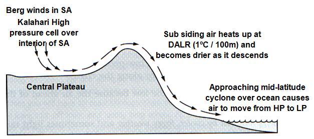
10 D. Berg Winds: Ahead of the mid latitude cyclone, berg wind conditions occur, where air flows from the Kalahari High Pressure cell to the costal low pressure. As the air subsides from the plateau and down the escarpment, it heats at Dry Adiabatic temperature lapse rate and become drier and hotter. This causes hot dry uncomfortable conditions which is generally replaced quickly with cold conditions associated with the cold front. It causes veld fires. Brought to you by Page 10

11 Brought to you by Page 11
12 X-AMPLE QUESTIONS: Question 1: Refer to the FIGURE 1A below showing the weather forecast for 15 May FIGURE 1B is a cross-section through the eastern half of the country explaining the sunny conditions at all the inland weather stations. FIGURE 1A: FIGURE 1B Brought to you by Page 12
 (4) 1.4 With reference to FIGURE 1B, explain why sunny conditions are indicated for all the inland weather stations. (3 x 2) (6) 1.")
13 1.1 What is meant by the term inversion shown in FIGURE 1B? (1 x 2) (2) 1.2 Name the high-pressure cell associated with the label subsided air of continental origin. (1 x 2) (2) 1.3 Why does an inversion develop at the lower side of the high pressure cell mentioned in QUESTION 1.2? (2 x 2) (4) 1.4 With reference to FIGURE 1B, explain why sunny conditions are indicated for all the inland weather stations. (3 x 2) (6) 1.5 Will the inversion shown in FIGURE 1B be higher or lower than its current position during the summer months? (1 x 2) (2) 1.6 The vertical positional change of the inversion from winter to summer is of great importance to farmers on the South African plateau. Explain this statement. (2 x 2) (4) [20] Question 2: 2.1 Refer to MAP 1 to answer the questions MAP Does this map illustrate summer or winter conditions? (1 x 2) (2) Motivate you answer in (3 x 2) (6) Identify the weather feature called Celestine in the North Eastern corner of the map. (1 x 2) (2) Where and under what conditions did Celestine develop? (4 x 2) (8) Explain what weather can be expected at Celestine. (3 x 2) (6) Which parts of SA will be influenced by the weather systems like Celestine? (1 x 2) (2) When will Celestine dissipate? (3 x 2) (6) Explain how the rain over the central interior developed. (3 x 2) (6) Brought to you by Page 13
 (2) 2.2.4. Describe the weather conditions in Durban. (3 x 2) (6) 2.2.5. Explain why the weather is like what you mentioned in 2.2.4. (3 x 2) (6) 2.2.6. Identify the 3 high pressures on the map.")
14 2.2 Refer to Map 2 on the following page o answer the following questions: MAP Does this map illustrate summer or winter conditions? (1 x 2) (2) Motivate you answer in (3 x 2) (6) Identify the weather systems South of SA and over SA. (1 x 2) (2) Describe the weather conditions in Durban. (3 x 2) (6) Explain why the weather is like what you mentioned in (3 x 2) (6) Identify the 3 high pressures on the map. (3 x 2) (6) Describe the weather over the interior of SA. (3 x 2) (6) Account for the weather over the interior of SA. (3 x 2) (6) Question 3: Refer to FIGURE 3.1 showing the formation of a storm line. 3.1 What is meant by the term storm line as mentioned in the statement above? (1 x 2) (2) 3.2 Describe some of the processes (air movement, influx of air) which lead to line thunderstorms occurring. (3 x 2) (6) 3.3 What name is given to the band of low pressure that extends across the South African interior along which line thunderstorms develop? (1 x 2) (2) 3.4 Do line thunderstorms develop on the eastern or western side of the band of low pressure mentioned in QUESTION 3.3? (1 x 2) (2) 3.5 Discuss the consequences of line thunderstorms for farming activities in South Africa s interior. (2 x 2) (4) Brought to you by Page 14

15 Figure 3.1. X-ERCISE QUESTIONS Question 1: The Kalahari high-pressure cell causes a subsidence inversion over the South African interior. The base height of this subsidence inversion varies from summer to winter. Study FIGURE 2.4 below, a cross-section that shows how the base height of the subsidence inversion varies from summer to winter. Brought to you by Page 15
16 1.1 Define the term temperature inversion. (1x2) (2) 1.2 Which of the diagrams, Figure 2.4A or 2.4B, represents summer months? (1x2) (2) 1.3 Give one reason for your answer to Question 1.2. (1x2) (2) 1.4 Describe the effect that the base height of the subsidence inversion will have on the climate of the South African interior during summer months. (4x2) (8) Question 2: Figures 2.3A and 2.3B show weather conditions that South Africa experience at different times of the year. Also read the extract on droughts below. If the conditions illustrated in Figure 2.3B persist, South Africa may experience a severe drought. EXTRACT Hot, dry weather from January to March 2007 wilted crops in southern Africa. The severe drought produced near-record temperatures that, combined with a lack of rainfall, caused extensive crop damage, particularly in western crop areas. In South Africa, the anticipated yield from the corn crop dropped from ten million tons in December to six million tons in April, because farmers could not plant in the dry conditions and many of the crops that were planted, wilted in the dry heat. The last South African drought of this magnitude occurred in 1992.The CSIR said, The and droughts were the most Brought to you by Page 16

17 severe meteorological droughts of the 20th century in southern Africa. In the drought, 70% of the crops failed. It was estimated that half of the population in the affected area was at risk of malnutrition, other related health problems, and even starvation. 2.1 During which season would South Africa experience the weather conditions represented in A and B respectively? (2x2) (4) 2.2 Name the weather system labelled X on both diagrams. 1X2) (2) 2.3 Weather system X is responsible for the development of stable conditions which frequently occur over the South African interior during winter. Briefly explain why weather system X is responsible for the development of the stable conditions over the interior. (2X2) (4) 2.4 In which one of the diagrams, A or B, is the above-mentioned condition clearly visible? (1X2) (2) 2.5 Figure 2.3C is a graph showing the vertical temperature gradient as experienced in Figure 2.3.B. (a) Describe the temperature changes as shown on the graph in figure 2.3C. (3X2) (6) (b) What is the zone labelled Y known as? (1X2) (2) 2.6 What is a drought? (1X2) (2) 2.7 Explain why the persistence of the condition illustrated in Figure 2.3B can result in drought over the South African interior. (3x2) (6) 2.8 Write a short essay (no longer than 12 lines) in which you discuss measures that can be introduced to reduce the effect of persistent droughts in South Africa. Also give reasons why it is important to reduce the effect of persistent droughts. (6x2) (12) Question 3: Refer to FIGURE 2.3 showing the position of the three high-pressure cells over Southern Africa that has major effects on the weather and climate. 3.1 Identify the THREE high pressure cells labelled X, Y and Z respectively (3x2) (6) Brought to you by Page 17
 is mainly responsible for the different weather conditions experienced over the South African interior during summer and winter? (1x2) (2) 3.")
18 3.2 Which ONE of the three high-pressure cells mentioned in QUESTION 3.1(a) is mainly responsible for the different weather conditions experienced over the South African interior during summer and winter? (1x2) (2) 3.3 State and explain THREE difference in the weather conditions experienced during winter and summer over the South African interior by referring to the role played by the high-pressure cell mentioned in QUESTION 3.1(b). (3x2) (6) 3.4 Which season does this synoptic map represent and give a reason for you answer. (2x2) (4) 3.5 Give a reason from the map to support that the weather systems are high pressure cells (1x2) (2) 3.6 Name the ocean currents that are found on the east and west coast of RSA. (2x2) (4) Question 4: The Figure below illustrates the development of thunderstorms belt over South Africa. Refer to the diagrams below to answer the following questions Identify the weather features labelled P and Q respectively on the map. (2) 4.2. State the season that is indicated in the figure. (1 x 2) (2) 4.3. Motivate your answer in 4.2. (2 x 2 = 4) Brought to you by Page 18
19 4.4. Compare the winds labelled S and T in table form. (4 x 1 = 4) 4.5. Explain why clouds form over the central part of South Africa. (2 x 2 = 4) 4.6. What type of rain will occur along the thunderstorm boundary? (1) 4.7. Give one advantages and one disadvantage of line thunderstorms. (2 x 2 = 4) Brought to you by Page 19
20 ANSWERS TO HOMEWORK X-ERCISES SESSION 3: FACTORS THAT INFLUENCE WEATHER IN SOUTH AFRICA Question 1: 1.1 A rise/ increase in temperature with increase in height/ altitude. (1x2) (2) B. (1x2) (2) 1.3 Inversion layer is above the escarpment. The base of the inversion is higher above sea level Moist air is adverted onto the plateau (1x2) (2) 1.4 Summer Moist air will reach the interior High humidity More condensation Cloud formation Precipitation [Any four for Summer] (4x2) (8) Question 2: 2.1 A = summer B = winter (2X2) (4) 2.2 Kalahari / Continental High Pressure Cell (1X2) (2) 2.3 Descending air Air warms adiabatically as it goes down Blocks moisture No condensation will occur [Any two] (2X2) (4) 2.4 B (1X2) (2) 2.5 (a) From 0 to 1000 m there is a decrease in temperature with height At Y there is an increase in temperature with height Above Y there is a decrease in temperature with height (3X2) (6) (b) Temperature inversion (1X2) (2) 2.6 A period when rainfall is below average for a region during which vegetation cover decreases. (1X2) (2) 2.7 Kalahari HP remains lower than the escarpment Moisture is blocked from the ocean to reach the interior The Kalahari HP is associated with stable air Rainfall will decrease over the interior If the stability of air persists the interior will experience dry conditions over a period of time (3X2) (6) 2.8 Prevention measures Plant trees to reduce run-off and increase infiltration Eliminate alien trees which use high quantities of water Build dams in areas with low evaporation Brought to you by Page 20
21 Question 3: Contour ploughing to reduce run-off/ apply scientific ploughing techniques Limit irrigation in dry areas/ less wasteful irrigation techniques Water transfer schemes to increase water Recycling of water for re-use Conserve underground water supplies Decentralisation of activities away from one major water source Public awareness campaigns on importance of using water sparingly Importance of introducing preventative measures Droughts reduce yields of crop farmers Reduction in number of livestock Negative implication for exporting Farmers suffer economically Farm workers laid off Fewer raw materials for industries Unemployment rises Balance of trade affected negatively [Any SIX must include both sections] (6x2) (12) 3.1 X - South Atlantic (St. Helena) HP Y- Kalahari (Continental) HP Z - South Indian (Mauritius) HP (3X2) (6) 3.2 Y / Kalahari (Continental) HP (1x2) (2) 3.3 Summer Winter Moist air Dry air Cloudy No clouds Rainfall Little/no rain No frost Frost at night (3x2) (6) 3.4 Winter the inland HP / Kalahari HP on the land (2x2) (4) 3.5 Anticlockwise circulation in SH (1x2) (2) 3.6 Warm Mozambique Current East and Cold Benquela West (2x2) (4) Question 4: 4.1. P South Atlantic Ocean High pressure Q South Indian Ocean High Pressure cell (2 x 1) (2) 4.2. Summer (1x2) (2) 4.3. Cloud formation over the interior i ndicates Low Pressure over central plateau no Kalahari HP Land must be warm to cause Low pressure and drag wind in from HP s Moisture boundary over land HP s far from land (2x2) (4) Brought to you by Page 21
22 4.4. S South Westerly s Cold, dry, stable T - North Easterlies Moist, warm, unstable (2x2) (4) 4.5. The stable cold air from the SW lifts the warm moist unstable air from NE as it meets along the moisture front. Warm conditions overland in summer contributes to instability. Air is lifted, cooled and reaches dew point temperature and condensation takes place and clouds form. (2x2) (4) 4.6. Convection rain heavy thunder showers (2x2) (2) 4.7. Advantage: - supply water for rivers, - faming Disadvantage: - showers cause flooding - hail can cause damage to crops - many areas does not get rain (2x2) (4) Brought to you by Page 22
Wind is caused by differences in air pressure created by changes in temperature and water vapor content.
 Topic 8: Weather Notes, Continued Workbook Chapter 8 Wind is caused by differences in air pressure created by changes in temperature and water vapor content. Wind blows from high pressure areas to low
CLIMATOLOGY. GEOGRAPHY Grade 12
 CLIMATOLOGY Checklist Make sure you: Are able to discuss and analyse Mid-latitude and Tropical Cyclones Understand Subtropical Anticyclones and the affect of the resultant weather over South Africa. Can
Chapter 8 Air Masses
 Chapter 8 Air Masses Air Masses - 1 1. An Air Mass is a large body of air usually about 1500 km across and several km thick, that has homogeneous physical properties. 2. The important physical properties
Nevis Hulme Gairloch High School John Smith Invergordon Academy. Gairloch High School / Invergordon Academy
 Nevis Hulme Gairloch High School John Smith Invergordon Academy 1 Gairloch High School / Invergordon Academy ATMOSPHERIC CIRCULATION The Three Cell Model Global Winds The ITCZ The purpose of this presentation
Weather EOG Review Questions
 Weather EOG Review Questions 1. Which statement best describes runoff? A Water vapor cools off and changes into water droplets. B Water in the form of rain, snow, sleet, or hail falls from clouds. C Precipitation
Understanding Weather
 Understanding Weather Images Graphic of the atmosphere. Enlarge Cirrus clouds. Enlarge Air masses Air masses are parcels of air that bring distinctive weather features to the country. An air mass is a
Lornshill Academy. Geography Department Higher Revision Physical Environments - Atmosphere
 Lornshill Academy Geography Department Higher Revision Physical Environments - Atmosphere Physical Environments Atmosphere Global heat budget The earth s energy comes from solar radiation, this incoming
ATMOSPHERIC CIRCULATION. WIND = The horizontal movement of air. Results from the differences in air pressure. Always moves from HIGH to LOW.
 ATMOSPHERIC CIRCULATION WIND = The horizontal movement of air. Results from the differences in air pressure. Always moves from HIGH to LOW. Pressure differences result from variations in temperature. AIR
Length of day for a full year. Ocean Gyres. Wet. Adiabatic. lapse rate, starts at. dewpoint Dry Adiabatic lapse rate
 Vernal Equinox March 20, 11:57 AM, CDT Sun will rise exactly in the east and set exactly in the west. All latitudes get 12 hours of day and 12 hours of dark. Length of day for a full year Wet Adiabatic
Air Masses and Fronts
 Air Masses and Fronts A huge body of air that has similar temperature, humidity, and air pressure at any given height is called an air mass. A single air mass may spread over millions of square kilometers
APPI PPG LECTURE 5: FURTHER METEOROLOGY
 LECTURE 5: FURTHER METEOROLOGY Introduction: This lecture covers Further Meteorology and aims to give you more of an understanding of advanced weather conditions and patterns. However Meteorology is a
Global Wind and Pressure Belts as a Response to the Unequal Heating of the Atmosphere
 GRADE 11 GEOGRAPHY SESSION 3: GLOBAL AIR CIRCULATION Key Concepts In this lesson we will focus on summarising what you need to know about: The mechanics present to create global wind and pressure belts
Social Studies CHAPTER 2: PART 2 CLIMATE AND WEATHER
 Social Studies CHAPTER 2: PART 2 CLIMATE AND WEATHER Climate Weather and Identity Climate and weather have a large influence on how Canadians build their identity. We will study the factors that contribute
The atmospheric circulation system
 The atmospheric circulation system Key questions Why does the air move? Are the movements of the winds random across the surface of the Earth, or do they follow regular patterns? What implications do these
Local Winds. Please read Ahrens Chapter 10
 Local Winds Please read Ahrens Chapter 10 Scales of Motion Microscale: meters Turbulent eddies Formed by mechanical disturbance or convection Lifetimes of minutes Mesoscale: km s to 100 s of km s Local
ATOMOSPERIC PRESSURE, WIND & CIRCULATION
 ATOMOSPERIC PRESSURE, WIND & CIRCULATION A. INTRODUCTION Important because: pressure patterns drive wind patterns which in turn drive oceanic circulation patterns o atmospheric & oceanic circulation: major
Unit Test Study Guide:
 Name: Homeroom: Date: Unit 6: Meteorology Study Guide Unit Test Study Guide: Atmosphere & Weather Use the summary points below as a resource to help you study for our unit test Monday! EARTH S ATMOSPHERE:
WINDS Understand the cause of wind and how it affects climate Chapter 4 Pages 59-67
 WINDS Understand the cause of wind and how it affects climate Chapter 4 Pages 59-67 What is Wind? A wind is a horizontal movement of air across a surface. Vertical movements are currents or updrafts and
Moisture and Stability in the Atmosphere
 Moisture and Stability in the Atmosphere Humidity can be measured as: HUMIDITY Absolute humidity the mass of water vapour in a volume of air (g/m 3.) Relative Humidity the proportion of the actual mass
LAB H - ATMOSPHERE AND CLIMATE LAB II STABILITY AND PRECIPITATION PATTERNS
 Introduction LAB H - ATMOSPHERE AND CLIMATE LAB II STABILITY AND PRECIPITATION PATTERNS This lab will provide students with the opportunity to become familiar with the concepts of atmospheric stability
PHSC 3033: Meteorology Stability
 PHSC 3033: Meteorology Stability Equilibrium and Stability Equilibrium s 2 States: Stable Unstable Perturbed from its initial state, an object can either tend to return to equilibrium (A. stable) or deviate
Deserts and Desert Environments
 Deserts and Desert Environments Introduction Aeolian geomorphology is the study of the effect of wind on Earth surface processes and landforms Wind: the movement of air from one place to another, specifically
In comparison to depressions, these can be quite boring, at least in terms of the weather they bring.
 Anticyclones In comparison to depressions, these can be quite boring, at least in terms of the weather they bring. In summary, anticyclones; Are larger than low pressure systems, Last longer than low pressure
Canada s Natural Systems. Canadian Geography 1202
 Canada s Natural Systems Canadian Geography 1202 Canada s Natural Systems Natural System: A system found in nature Here are the four natural systems that we will explore in the next few weeks 1. Canada
McKnight's Physical Geography 11e
 Chapter 2 Lecture McKnight's Physical Geography 11e Lectures Chapter 5 Atmospheric Pressure and Wind Michael Commons Ohio Northern University Atmospheric Pressure and Wind The Nature of Atmospheric Pressure
Canada s vast size creates a diverse range of weather conditions and climatic conditions. Warming trend for last 10 years Wet Spring Dry five summers
 Chapter 4 Weather and Climate Canada s vast size creates a diverse range of weather conditions and climatic conditions. Weather examples: Rainy today Snow tomorrow Fog on Wednesday 23 degree C today High
Weather drivers in Victoria
 August 2008 Weather drivers in Victoria Key facts Major weather drivers in Victoria are: El Niño - Southern Oscillation frontal systems cut-off lows blocking highs Southern Annular Mode cloudbands Figure
Lecture 13 El Niño/La Niña Ocean-Atmosphere Interaction. Idealized 3-Cell Model of Wind Patterns on a Rotating Earth. Previous Lecture!
 Lecture 13 El Niño/La Niña Ocean-Atmosphere Interaction Previous Lecture! Global Winds General Circulation of winds at the surface and aloft Polar Jet Stream Subtropical Jet Stream Monsoons 1 2 Radiation
Weather drivers in South Australia
 August 2008 Key facts Weather drivers in South Australia Major weather drivers in South Australia are: El Niño - Southern Oscillation frontal systems cut-off lows blocking highs Indian Ocean Dipole cloudbands
Water Budget I: Precipitation Inputs
 Water Budget I: Precipitation Inputs Forest Cover Global Mean Annual Precipitation (MAP) Biomes and Rainfall Forests won t grow where P < 15 / yr Forest type depends strongly on rainfall quantity, type
Atmospheric & Ocean Circulation-
 Atmospheric & Ocean Circulation- Overview: Atmosphere & Climate Atmospheric layers Heating at different latitudes Atmospheric convection cells (Hadley, Ferrel, Polar) Coriolis Force Generation of winds
Ocean Currents that Redistribute Heat Globally
 Ocean Currents that Redistribute Heat Globally Ocean Circulation Ocean Currents Fig. CO7 OCEAN CURRENTS Surface ocean currents are similar to wind patterns: 1. Driven by Coriolis forces 2. Driven by winds
Review for the second quarter. Mechanisms for cloud formation
 Review for the second quarter Mechanisms for cloud formation 1 Rising air expands and cools; Sinking air compresses and warms. (18) (24) Dry adiabatic lapse rate (10 o C/km): the rate of temperature decrease
First of all, you should know that weather and climate are not the same thing.
 First of all, you should know that weather and climate are not the same thing. WEATHER IS: Short term Limited area Can change rapidly Difficult to predict WEATHER is what s happening outside your window
LAB H - ATMOSPHERE AND CLIMATE LAB II STABILITY AND PRECIPITATION PATTERNS
 Introduction LAB H - ATMOSPHERE AND CLIMATE LAB II STABILITY AND PRECIPITATION PATTERNS This lab will provide students with the opportunity to become familiar with the concepts of atmospheric stability
ATS 351 Lecture 6. Air Parcel. Air Parcel Movement: Why does rising air expand and cool? Stability & Skew-T Diagrams
 ATS 351 Lecture 6 Stability & Skew-T Diagrams To demonstrate stability, a parcel of air is used Expands and contracts freely Always has uniform properties throughout Air Parcel Air Parcel Movement: Why
Santa Ana Winds. Surface weather map showing typical Santa Ana conditions.
 Santa Ana Winds Surface weather map showing typical Santa Ana conditions. High Desert Elevation ~1500-2000 ft Santa Ana Winds ~1500 meters 0 meters Santa Ana Winds ~875 mb ~1500 meters ~875 mb Horizontal
Chapter- 9. Multiple Choice Questions
 Chapter- 9 Multiple Choice Questions 1. The low-latitude climates: a. are located along the equator b. are located between the tropics of cancer and capricorn c. do not include the ITCZ d. are restricted
2 Air Masses and Fronts
 CHAPTER 16 2 Air Masses and Fronts SECTION Understanding Weather BEFORE YOU READ After you read this section, you should be able to answer these questions: How is an air mass different from a front? How
Meteorology I Pre test for the Second Examination
 Meteorology I Pre test for the Second Examination MULTIPLE CHOICE 1. A primary reason why land areas warm up more rapidly than water areas is that a) on land, all solar energy is absorbed in a shallow
Atmospheric Circulation
 Atmospheric Circulation Why do we say Earth's temperature is moderate? It may not look like it, but various processes work to moderate Earth's temperature across the latitudes. Atmospheric circulation
- wet tropical climate
 (1 of 13) Further Reading: Chapter 10 of the text book Outline - wet tropical climate - coastal trade wind climate - wet-dry and monsoon climate - dry tropical climate (2 of 13) Introduction Previously,
Meteorology. Circle the letter that corresponds to the correct answer
 Chapter 4 Worksheet 3 Meteorology Name: Circle the letter that corresponds to the correct answer 1) Natural convection and turbulence are most likely to occur when: a) temperature decreases rapidly with
Meteorology. Circle the letter that corresponds to the correct answer
 Chapter 7 Worksheet 2 Meteorology Name: Circle the letter that corresponds to the correct answer 1) Which of the following factors contributes to the general subsidence in the latitude zone 20 degrees
The student will be expected to demonstrate an understanding of the cause of winds and how winds affect climate.
 The student will be expected to demonstrate an understanding of the cause of winds and how winds affect climate. In this lesson you will: 2.3.1 Define the term prevailing winds. (k) 2.3.3 State the impact
Air Pressure and Wind
 Air Pressure and Wind 19.1 Understanding Air Pressure Air Pressure Defined Air pressure is the pressure exerted by the weight of air. Air pressure is exerted in all directions down, up, and sideways. The
1.3: CLIMATE GEOGRAPHY. pgs
 1.3: CLIMATE GEOGRAPHY pgs. 76-89 INTRODUCTION WEATHER: Is the combination of temperature, precipitation, cloud cover and wind that we experience EACH DAY. Example: 22 0 C and clear skies. CLIMATE: The
Atmospheric Circulation. Recall Vertical Circulation
 Today s topics: Atmospheric circulation: generation of wind patterns on a rotating Earth Seasonal patterns of climate: Monsoons and Sea Breezes Tropical Cyclones: Hurricanes and typhoons Atmospheric Circulation
Lecture 13 March 24, 2010, Wednesday. Atmospheric Pressure & Wind: Part 4
 Lecture 13 March 24, 2010, Wednesday Atmospheric Pressure & Wind: Part 4 Synoptic scale winds Mesoscale winds Microscale winds Air-sea interactions The largest synoptic scale wind. Monsoon: Arabic for
Envs, Geol, Phys 112: Global Climate. Energy-Atmosphere System Review Aguado & Bert, Ch. 1, 2, 3, 4, 5, 6, 9, 10
 Exam 1 Review Energy-Atmosphere System Review Aguado & Bert, Ch. 1, 2, 3, 4, 5, 6, 9, 10 Location on Earth (L04) Latitude & Longitude great circles, prime meridian, time zones, cardinal points, azimuth
Weather & Atmosphere Study Guide
 Weather & Atmosphere Study Guide 1. Draw a simple water cycle diagram using the following words: Precipitation, Evaporation, Condensation, Transpiration 2. In your own words, explain the difference between
Chapter. Air Pressure and Wind
 Chapter Air Pressure and Wind 19.1 Understanding Air Pressure Air Pressure Defined Air pressure is the pressure exerted by the weight of air. 19.1 Understanding Air Pressure Air Pressure Defined Air pressure
Name: Date: Day/Period: CGC1P1: Interactions in the Physical Environment. Factors that Affect Climate
 Name: Date: Day/Period: CGC1P1: Interactions in the Physical Environment PART A: Weather and Climate Factors that Affect Climate 1. The words weather and climate are often incorrectly used interchangeably.
Atmosphere Circulation
 Atmosphere Circulation Winds What Causes Winds? Difference in air pressure due to unequal heating of the atmosphere. Temperatures vary according to the amount of sun it gets. Uneven heating of the Earth
Explain List Describe Compare Identify
 Objective:S.W.A.B.T. Explain how an air mass forms. List the four main types of air masses. Describe how air masses affect the weather of North America. Compare the characteristic weather patterns of cold
3/22/11. General Circulation of the Atmosphere. General Circulation of the Atmosphere
 Chapter 10 General refers to the average air flow, actual winds will vary considerably. Average conditions help identify driving forces. The basic cause of the general circulation is unequal heating of
Higher Atmosphere. Earth s Heat Budget. Global Insolation. Global Transfer Of Energy. Global Temperatures. Inter Tropical Convergence Zone
 Higher Atmosphere Earth s Heat Budget Global Insolation Global Transfer Of Energy Global Temperatures Inter Tropical Convergence Zone Climate Graph Earth s Heat Budget Task 1 Use the Power Point to help
Land and sea breezes are an example of which type of heat transfer?
 TEST #7 REVIEW Land and sea breezes are an example of which type of heat transfer? Land and sea breezes are an example of which type of heat transfer? convection The diagram above represents what? The
CLIMATES IN SOUTH AFRICA
 CLIMATES IN SOUTH AFRICA South Africa has various climates throughout the country. It is in the Southern Hemisphere and is surrounded by ocean except for at its Northern borders. South Africa s climates
Fluid Circulation (Student Mastery Objectives) -The most frequent type of heat transfer of energy in the atmosphere is convection.
 -The most frequent type of heat transfer of energy in the atmosphere is convection.") Fluid Circulation (Student Mastery Objectives) -The most frequent type of heat transfer of energy in the atmosphere is convection. -Differences in density affect the circulation of fluids. Cold air is
Fluid Circulation (Student Mastery Objectives) -The most frequent type of heat transfer of energy in the atmosphere is convection. -Differences in density affect the circulation of fluids. Cold air is
Global Weather Patterns
 Global Weather Patterns AZ State Standards Concept 2: Energy in the Earth System (Both Internal and External) Understand the relationships between the Earth s land masses, oceans, and atmosphere. PO 2.
Monsoon. Arabic word mausim means season. Loose definition: a wind/precipitation pattern that shifts seasonally
 Monsoon Arabic word mausim means season Loose definition: a wind/precipitation pattern that shifts seasonally Classical criteria (Ramage 1971) Prevailing wind shifts 120 o between Jan & July Average frequency
Water Budget I: Precipitation Inputs
 Water Budget I: Precipitation Inputs Forest Cover Forests and Rainfall Forests won t grow where P < 15 / yr Forest type depends strongly on rainfall quantity, type (snow, rain) and timing (summer, winter)
Air Masses and Fronts. Holt Science and Technology Weather and Climate Chapter 2, Section 2
 Air Masses and Fronts Holt Science and Technology Weather and Climate Chapter 2, Section 2 Types of Air Masses Changes in weather are caused by the movement and interaction of air masses. An air mass is
18.1 Understanding Air Pressure 18.1 Understanding Air Pressure Air Pressure Defined Measuring Air Pressure Air pressure barometer
 18.1 Understanding Air Pressure 18.1 Understanding Air Pressure Air Pressure Defined Air pressure is the pressure exerted by the weight of air. Air pressure is exerted in all directions down, up, and sideways.
8 th Grade Science Meteorology Review
 8 th Grade Science Meteorology Review #1 Where does Earth get the energy that produces global weather patterns? A: The sun B: Humidity C: Air masses D: Cyclones A. The Sun #2 Do all of the areas on Earth
Warm front and cold front video 3:50
 Construct an explanation of the relationship between air pressure, weather fronts, and air masses and meteorological events such as tornados and thunderstorms Unpacked : Warm front and cold front video
CHAPTER 9. More on meteorology
 CHAPTER 9 More on meteorology 1). Atmospheric Pressure Atmospheric pressure is the pressure with which the atmosphere acts downwards due to its weight. Pressure decreases with altitude because the column
Atmospheric Circulation (Ch. 8) Ocean & Atmosphere are intertwined Gases & waters freely exchanged Wind Weather Climate
 Ocean & Atmosphere are intertwined Gases & waters freely exchanged Wind Weather Climate") Atmospheric Circulation (Ch. 8) Ocean & Atmosphere are intertwined Gases & waters freely exchanged Wind Weather Climate Atmospheric Structure Consists of Layers Separated by Temperature Stratosphere: Temperature
Atmospheric Circulation (Ch. 8) Ocean & Atmosphere are intertwined Gases & waters freely exchanged Wind Weather Climate Atmospheric Structure Consists of Layers Separated by Temperature Stratosphere: Temperature
Lecture Outlines PowerPoint. Chapter 18 Earth Science 11e Tarbuck/Lutgens
 Lecture Outlines PowerPoint Chapter 18 Earth Science 11e Tarbuck/Lutgens 2006 Pearson Prentice Hall This work is protected by United States copyright laws and is provided solely for the use of instructors
Atmospheric Circulation. Density of Air. Density of Air: H 2 O and Pressure effects
 Today s topics: Atmospheric circulation: generation of wind patterns on a rotating Earth Seasonal patterns of climate: Monsoons and Sea Breezes Tropical Cyclones: Hurricanes and typhoons Atmospheric Circulation
Small- and large-scale circulation
 The Earth System - Atmosphere II Small- and large-scale circulation Atmospheric Circulation 1. Global atmospheric circulation can be thought of as a series of deep rivers that encircle the planet. 2. Imbedded
CHAPTER 6 Air-Sea Interaction
 CHAPTER 6 Air-Sea Interaction What causes Earth s seasons? Tilt (23.5 ) responsible for seasons 2011 Pearson Education, Inc. Distribution of Solar Energy Distribution of Solar Energy Atmosphere absorbs
PHYSICAL GEOGRAPHY. By Brett Lucas
 PHYSICAL GEOGRAPHY By Brett Lucas ATMOSPHERIC PRESSURE AND WIND Atmospheric Pressure and Wind Atmospheric Processes The Nature of Wind General Circulation of the Atmosphere Modifications of General Circulation
ESCONDIDO FIRE DEPT TRAINING MANUAL Section Engine Module Page 1 of 15 Wildland Fire Weather Revised
 Engine Module Page 1 of 15 WEATHER Weather is the most critical element of fire behavior. Weather is also the most unpredictable element. Firefighting personnel should be knowledgeable in local weather
Weather Unit Study Guide
 Weather Unit Study Guide - 2018 Weather vs Climate What does weather measure? The condition of the earth's atmosphere at a particular time and place. How are climate and weather different? Climate is the
Physical Geography. Physical Geography III of the United States and Canada. Formation of Great Lakes. Climates of North America. Definitions 2/21/2013
 Physical Geography III of the United States and Canada Ancient Glacial Lakes As the Ice Age ended, areas of North America beyond the terminal moraine were flooded with melt water Prof Anthony Grande AFG
Topic 4 Temperature, Atmospheric Circulation and Climate. Temperature Concepts and Measurement 10/2/2017. Thermometer and Instrument Shelter
 Topic 4 Temperature, Atmospheric Circulation and Climate Temperature Controls Global Temp. Patterns Atmospheric Circulation Primary High and Low Pressure Areas Global Circulation Model Local Winds Ocean
Applied Earth Science Climate Exam Practice Questions Page 1
 Name: 1. Which combination of climate factors generally results in the coldest temperatures? A) low elevation and low latitude B) low elevation and high latitude C) high elevation and low latitude D) high
Atmosphere & Weather. Earth Science
 Atmosphere & Weather Earth Science Energy Transfer in the Atmosphere Earth s energy is provided by the SUN! Energy is important to us because it 1. Drives winds and ocean currents. 2. Allows plants to
Ecology. Professor Andrea Garrison Biology 3A Illustrations 2014 Cengage Learning unless otherwise noted
 Ecology Professor Andrea Garrison Biology 3A Illustrations 2014 Cengage Learning unless otherwise noted Ecology Ecology (oikos = house) is the study of where an organism lives and all the interactions
Greenhouse Effect Activity
 Greenhouse Effect Activity Objectives: The student will: 1. Read and use weather instruments. 2. Collect and record temperature readings. 3. Describe the concept of the greenhouse effect. Materials: Fish
GEOGRAPHY UNIT 2 REVIEW. 1. The daily atmospheric conditions, such as heat, moisture and air movement for a particular area are known as
 UNIT 2 REVIEW GEOGRAPHY Name: 1. The daily atmospheric conditions, such as heat, moisture and air movement for a particular area are known as 2. The average conditions of the weather for a long period
El Niño Unit (2.5 pts)
") T. James Noyes, El Camino College El Niño Unit (Topic 9B) page 1 Name: Section: El Niño Unit (2.5 pts) El Niño is a warm ocean current that flows along the Equator and towards the west coast of South America
T. James Noyes, El Camino College El Niño Unit (Topic 9B) page 1 Name: Section: El Niño Unit (2.5 pts) El Niño is a warm ocean current that flows along the Equator and towards the west coast of South America
(a) Deflection to the left, slower velocity means greater deflection, greatest deflection at the south pole
 Deflection to the left, slower velocity means greater deflection, greatest deflection at the south pole") 1 Test 2 Aid Sheet Exam: A single 8.5 by 11 inch aid sheet (both sides) and Type 2 nonprogrammable calculators are permitted. The time allowed for this Test (Part A plus Part B combined) is 90 minutes.
1 Test 2 Aid Sheet Exam: A single 8.5 by 11 inch aid sheet (both sides) and Type 2 nonprogrammable calculators are permitted. The time allowed for this Test (Part A plus Part B combined) is 90 minutes.
Natural Regions of the World
 Natural Regions of the World Revision for Competitive Exams 10x10learning.com 1 Concept of Natural Regions provides a framework for understanding the diversity of physical and biological environment Taiga
Vertical Motion and Atmospheric Stability
 Lesson 4 Vertical Motion and Atmospheric Stability This lesson describes the vertical structure of the atmosphere, atmospheric stability and the corresponding vertical motion. Adiabatic diagrams are introduced
CfE Higher Geography Physical Environments. The Inter-tropical Convergence Zone
 CfE Higher Geography Physical Environments The Inter-tropical Convergence Zone * We already know that the Equator is a belt where the trade winds converge, bring air from the Tropics to the Equator. It
Local Winds & Microclimates. Unit 2- Module 1
 Local Winds & Microclimates Unit 2- Module 1 Objectives Overview of local winds (sea & land breezes, valley winds) Overview of microclimates (valley, urban, woodland) Local Winds Local Winds Local winds
Winds and Ocean Circulations
 Winds and Ocean Circulations AT 351 Lab 5 February 20, 2008 Sea Surface Temperatures 1 Temperature Structure of the Ocean Ocean Currents 2 What causes ocean circulation? The direction of most ocean currents
Lecture The Oceans
 Lecture 22 -- The Oceans ATMOSPHERE CIRCULATION AND WINDS Coriolis effect Prevailing winds and vertical circulation Zones of pressure, evap. & ppt. Factors modifying global winds -- Differential heating
Agronomy 406 World Climates
 Agronomy 406 World Climates January 30, 2018 Monsoons. Ocean properties and circulation. Review for today: Online textbook: 1.3.1 (Sea water) Composition and properties. For Thursday: Rahmstorf, S.: The
Heart of England Offshore Cruising Association HOEOCA
 Sailing Weather Penny Tranter 19 January 2017 Heart of England Offshore Cruising Association HOEOCA Weather and climate The difference between weather and climate? Weather is the state of the atmosphere
Cloud Development and Forms
 Chapter 6 Lecture Understanding Weather and Climate Seventh Edition Cloud Development and Forms Redina L. Herman Western Illinois University Mechanisms That Lift Air When air lifts, clouds develop and
Scales of Atmospheric Motion
 Lecture 12 Local Wind Systems Scales of Atmospheric Motion Small turbulent eddies (swirls) A synoptic eddy 1 Coriolis Effect The larger the scale, the longer the life time. Wind shear and turbulent eddy
Pacific Climate Variability
 Pacific Climate Variability Pacific Islands Climate Education Partnership You may have heard the term climate variability. What does the term climate variability mean? What are the causes and effects of
3 Global Winds and Local Winds
 CHAPTER 1 3 Global Winds and Local Winds SECTION The Atmosphere BEFORE YOU READ After you read this section, you should be able to answer these questions: What causes wind? What is the Coriolis effect?
GEOGRAPHY PAPER 1 MEMORANDUM
 GEOGRAPHY PAPER 1 MEMORANDUM QUESTION 1 1.1 1.1.1 Katabatic, cold 1.1.2 warmer, north-facing 1.1.3 warmer 1.2 1.2.1 true 1.2.2 false 1.2.3 true 1.2.4 true 1.2.5 false 1.3 1.3.1 Inter-tropical convergence
ATMS 310 Tropical Dynamics
 ATMS 310 Tropical Dynamics Introduction Throughout the semester we have focused on mid-latitude dynamics. This is not to say that the dynamics of other parts of the world, such as the tropics, are any
Section 6. The Surface Circulation of the Ocean. What Do You See? Think About It. Investigate. Learning Outcomes
 Chapter 5 Winds, Oceans, Weather, and Climate Section 6 The Surface Circulation of the Ocean What Do You See? Learning Outcomes In this section, you will Understand the general paths of surface ocean currents.