SAN FRANCISCO, SAN PABLO AND SUISUN BAYS HARBOR SAFETY PLAN
|
|
|
- Brittany West
- 6 years ago
- Views:
Transcription

1 SAN FRANCISCO, SAN PABLO AND SUISUN BAYS HARBOR SAFETY PLAN Voted on by the Harbor Safety Committee of the San Francisco Bay Region June 8, 2017 Pursuant to the California Oil Spill and Prevention Act of 1990 Submitted by the Harbor Safety Committee of the San Francisco Bay Region c/o Marine Exchange of the San Francisco Bay Region 505 Beach Street, Suite 300 San Francisco, California Telephone: (415)
2 Table of Contents Introduction... iii Harbor Safety Committee Organization... v Executive Summary... viii I. Geographic Boundaries... 1 II. General Weather, Currents and Tides... 3 III. Aids to Navigation IV. Anchorages V. Surveys, Charts and Dredging VI. Contingency Routing VII. Vessel Speed and Traffic Patterns VIII. Accidents and Near-Accidents IX. Communication X. Bridges XI. Small Passenger Vessels Ferries XII. Small Vessels XIII. Vessel Traffic Service XIV. Tug Escort / Assist for Tank Vessels XV. Pilotage XVI. Underkeel Clearance XVII. Economic and Environmental Impacts XVIII. Plan Enforcement XIX. Recommendations Implemented or Addressed XX. Harbor Safety Committee Educational Materials Table of Appendices... ii Table of Maps... ii i
3 Table of Appendices Appendix A: Best Maritime Practices Appendix B: Bylaws of the Harbor Safety Committee of the San Francisco Bay Region Appendix C: Annual Work Group Reports Appendix D: Tug Escort Regulations and OSPR Escort Recap Appendix E: Clearing House List of Certified Tug Escort Boats Appendix F: Clearing House Report on Escorted Vessel Movements Appendix G: Clearing House List of Tanker Movements and Total Vessel Movements in San Francisco Bay Appendix H: Recommendations for Conducting Escort Training On San Francisco Bay Appendix I: Sites of the Physical Oceanographic Real Time System (PORTS) Instruments That Measure Currents, Tides, Meteorological Data And Salinity Appendix J: Vehicular Bridge Inventory Appendix K: Coast Guard Marine Safety Office Bay Port Safety Statistics Appendix L: Coast Guard Marine Safety Office Bay Pollution Statistics Appendix M: SLC-MFD Waterborne Petroleum Cargo Statistics Appendix N: Assessment of Offshore Emergency Towing Capabilities Appendix O: Recommendations to Be Addressed Table of Maps Map 1 Geographic Limits of the Harbor Safety Plan Map 2 Vessel Traffic System San Francisco Service Area Map 3 Tug Escort Zones ii
4 Introduction In 1990, the California Legislature enacted the Oil Spill Prevention and Response Act (OSPRA). The goals of OSPRA are to improve the prevention, removal, abatement, response, containment and cleanup and mitigation of oil spills in the marine waters of California. The Act (SB 2040) created harbor safety committees for the major harbors of the state of California to plan for the safe navigation and operation of tankers, barges, and other vessels within each harbor [by preparing] a harbor safety plan, encompassing all vessel traffic within the harbor. The Harbor Safety Committee of the San Francisco Bay Region was officially sworn in September 18, 1991 and held its first meeting on that date. The original Harbor Safety Plan for San Francisco, San Pablo and Suisun Bays was adopted August 13, SB 2040 mandates that the Harbor Safety Committee must annually review its previously adopted Harbor Safety Plan and recommendations and submit the annual review to the OSPR Administrator for comment. The full committee of the Harbor Safety Committee holds regular monthly public meetings. The committee chairperson may appoint work groups to review the mandated components of the Harbor Safety Plan and timely issues. All committee and work group meetings are noticed to the public. Public comments are received throughout discussions of the various issues, which results in full public participation in developing the recommendations of the Harbor Safety Plan of the San Francisco Bay Region. The San Francisco Bay Harbor Safety Plan encompasses a series of connecting bays, including the San Francisco, San Pablo and Suisun Bays, and the Sacramento River to the Port of Sacramento and the San Joaquin River to the Port of Stockton. The distance from the San Francisco lighted horn buoy outside the Bay to the Ports of Stockton and Sacramento is approximately one hundred miles. The 548-square-mile Bay has an irregular 1,000 mile shoreline composed of a variety of urban and suburban areas, marshes and salt ponds. Several significant islands are located within the Bay, including Angel Island, Alcatraz Island, Yerba Buena Island and Treasure Island. Map 1 depicts the geographic boundaries of the area covered by the Harbor Safety Plan. The San Francisco Bay system is the largest estuary on the Pacific Coasts of North and South America. Waters from the two major river systems and the Bay flow through the Golden Gate, which is less than a mile wide at its narrowest point. Because of the volume of water moving through the narrow opening on a daily basis, tides and strong currents occur in the Bay. While the Bay is extremely deep (356 feet) under the Golden Gate Bridge because of the swiftly moving volume of water, the Bay is very shallow in many areas and subject to sedimentation from the rivers emptying into the Bay. Sediment also is deposited outside the entrance to San Francisco Bay where a semicircular bar extends into the Pacific Ocean. The Bay itself is less than 18 feet deep over two-thirds of its area, and the Bay bottom is predominantly mud. A dredged Main Ship Channel allows deepdraft vessels to navigate the Bay. iii
5 The Bay presents a number of hazards to navigation, such as strong tides and currents and variable bottom depths, which confine large vessels to defined shipping lanes within the Bay. Navigating the Bay becomes more complex during periods of restricted visibility. The San Francisco Bar Pilots regularly compile recommended guidelines for safe navigation entitled Port Safety Guidelines for Movement of Vessels on San Francisco Bay and Tributaries. The guidelines are sent to members of the shipping industry, and are based on a general consensus among pilots as to recommended navigation practices. The Bay supports a variety of uses, including shipping, fishing, ferry transit and various recreational activities. There are seven ports, a number of marine terminals, and military facilities at the Military Ocean Terminal Concord (MOTCO) and Moffet Field. Because the water depths near refineries in Contra Costa and Solano Counties cannot safely accommodate larger oil tankers, large tankers lighter oil to smaller tankers or barges to move cargo in-bay to marine terminals. Map 3 identifies the location of marine terminals in the plan area. In addition, an expanding ferry system annually makes over 85,000 (2004) trips, mainly to and from San Francisco in the central part of the Bay. Because much of the Bay shoreline is urbanized, recreational boating and the growing sports of board sailing and paddle sports are popular, with an estimated 20,000 boat berths around the Bay, exclusive of the Sacramento and San Joaquin Rivers, as well as numerous boat launch sites. The shipping industry is a particularly vital part of the Bay Area economy. Shipping spokespersons estimate that approximately 100,000 jobs are dependent upon the shipping industry and that the industry contributes nearly $5 billion to the regional economy. Thus, vessel traffic in the Bay consists of a complex variety of inbound and outbound vessels, wholly in-bay vessel movements, tugs, government vessels, ferries, recreational boats, commercial and sports fishing boats, board sailors, paddle sports enthusiasts and personal watercraft (jet skis) within the series of bays, channels and rivers that comprise the San Francisco Bay planning area. iv
6 Organization of the Harbor Safety Committee of the San Francisco Bay Region The San Francisco Harbor Safety Committee consists of representatives from the following: ports (four), dry cargo vessel operators (two), tank ship operators (two) or one ship operator and one oil marine terminal operator, and one tug operator, one tank barge operator, a passenger ferry or excursion vessel operator, the regional pilot organization, a vessel labor union, a commercial fishing representative, a recreational boater, an environmental organization, the U.S. Coast Guard Captain of the Port, the U.S. Army Corps of Engineers, the National Oceanic and Atmospheric Administration and the San Francisco Bay Conservation and Development Commission. A complete list of committee members is found in Appendix B. Chair...Captain Lynn Korwatch Marine Exchange of the San Francisco Bay Region 505 Beach Street, Suite 300 San Francisco, California Ph: (415) Fax: (415) korwatch@sfmx.org Vice Chair...John Berge Pacific Merchant Shipping Association 70 Washington Street, Suite 305 Oakland, California Ph: (510) Fax: (510) jberge@pmsaship.com Executive Secretary...Captain Lynn Korwatch Marine Exchange of the San Francisco Bay Region 505 Beach Street, Suite 300 San Francisco, California Ph: (415) Fax: (415) korwatch@sfmx.org v
7 Harbor Safety Committee Work Groups Dredging Chad Culbertson, Chair Chevron Shipping Co. LLC 841 Chevron Way Richmond, California Phone: (510) Ferry Operations... Tom Kirsch, Chair Blue & Gold Fleet Pier 41 Marine Terminal San Francisco, California Ph: (510) Navigation... Robert Carr, Chair San Francisco Bar Pilots Pier 9, East End San Francisco, California Ph: (203) PORTS... Chris Peterson, Chair Port of Oakland 530 Water Street Oakland, California Phone: (510) Fax: (510) Prevention through People... Margot Brown, Chair National Boating Federation 3217 Fiji Lane Alameda, California Ph: (510) Fax: (510) Tugs... Robert Gregory, Chair Foss Maritime Co Canal Blvd. Richmond, California Ph: (510) Fax: (510) vi
8 For a list of all Committee members, see: To review the regulations governing the Harbor Safety Committee, see: Highlighted headings in this Safety Plan indicate Best Maritime Practices (BMPs) that have been adopted by the SF Harbor Safety Committee. For a compilation of BMPs, please see Appendix A. vii
9 Executive Summary 2016/2017 The Harbor Safety Committee continued its collaborative process to engage the maritime community in working to increase navigation safety in the Bay. The Tug Work Group culminated nearly a year s worth of investigation and submitted to the OSPR Administrator an assessment of emergency towing capabilities in the areas offshore, as required by Senate Bill 414. Also during : The Dredging Issues Work Group authored a letter to the House Appropriations Committee requesting support for FY 2018 funding for dredging operations. The Ferry Operations Work Group worked with maritime partners as the Bay Area s ferry system grew in a robust economy. The Navigation Work Group met to discuss requirements for laying buried cables and pipelines in the Bay, specifically where these cross or infringe on a navigational channel. The workgroup developed and forwarded a set of proposed amendments to the USACE national permit process; however, these were ultimately not accepted by USACE. See Appendix C, Annual Work Group reports, for additional activities over the past year. viii
10 I. I. Geographic Boundaries The policies and recommendations contained in the San Francisco Bay Harbor Safety Plan address vessel safety in the marine waters bounded to the west by the San Francisco Offshore Precautionary Area, the navigable waters shoreward of the San Francisco Offshore Precautionary Area east of W. and north of N. extending eastward through the Golden Gate, San Francisco, San Pablo and Suisun Bays, up to and including the Ports of Sacramento and Stockton, which establish the eastern boundary of the plan area. NOAA charts cover the Harbor Safety Plan Area. (See map following page.) 1
11 2 I.
12 II. II. General Weather, Currents and Tides The majority of the background information presented here is derived from the National Weather Service and can be viewed in its entirety in the U.S. Coast Pilot 7, Pacific Coast, published by NOAA and available from the following website: The Coast Pilot information is augmented with observations from local sources. Ships traveling into the Bay encounter diverse weather, currents, tides and bottom depths. Because of the often varied and changing set of harbor conditions, mariners must be observant about current conditions to navigate safely. Weather Bay Area weather is seasonably variable with three discernible seasons affecting the marine environment. The Bay Area has several climate regimes, or microclimates. Significant differences in temperature, winds, and fog patterns over relatively short distances are due to variations in air mass between land and sea and to the complex terrain of the coastal mountain ranges. Wind direction is generally west to east; however, there is a great deal of variation due to the complex geography. Because of the many microclimates of the San Francisco Bay Area, mariners who navigate the waters from outside the Golden Gate, through the San Francisco Bay and Delta and into the Central Valley must be aware of how weather conditions can change significantly over short distances and over short periods of time. Mariners must also be aware of the unique weather conditions and weather hazards that are most prevalent during each season. Winds Winter. Winter is the season with the most significant seas, both in terms of locally driven wind waves as well as open ocean swells that are generated by long fetches of strong winds over the eastern Pacific. Winter winds from November to February shift frequently and have a wide range of speeds dependent on the procession of offshore high and low pressure systems. Calms occur 15 to 40 percent of the time inside the Bay and 10 to 12 percent outside. Extreme wind conditions of 50 knots gusting to 75 knots have occurred during the winter. The strongest winds tend to come from the Southeast to Southwest ahead of a cold front. 3
13 II. Seas are sometimes large enough to produce breakers across the San Francisco Bar, several miles west of the Golden Gate. These breaking waves in the open ocean present a significant danger to mariners, especially those unfamiliar with the area. Breakers across the bar are most common with a long period westerly swell around the time of maximum ebb current through the Golden Gate. Spring. Spring is generally the windiest season, with average speeds in the Bay of 6-12 knots, with wind speeds of knot winds up to 40 percent of the time. Wind speeds sometimes reach gale force over the coastal waters outside the Golden Gate, and approach gale force locally in northern San Francisco Bay. Wind direction stabilizes as the Pacific High Pressure System becomes the dominant weather influence. Northwesterly winds are generated and reinforced by the sea breeze. Inside the Bay, winds are channeled and vary from Northwest to Southwest. Strong springtime winds over the coastal waters produce rough and choppy seas with a short period swell. The large long-period swells common during the winter months still roll through the coastal waters quite often during the early spring, but taper off considerably by late spring as the storm track across the Pacific becomes less active. Summer. Summer winds are the most constant and predictable. The winds outside the Golden Gate are normally from Northwest to North and are generated by the strong Pacific High Pressure System. This condition lasts through October until the system weakens and the winter cycle starts again. Winds inside the Bay are local depending on the land contours acting on the onshore flow. One of the few occurrences that will alter this pattern is when a high pressure system settles over Washington and Oregon. When this happens a Northeast flow develops, bringing warm dry air and clearing away the summer fog. Small craft advisory conditions (20 to 25 knots) occur nearly every day in summer through the central and northern San Francisco Bay and eastward through the Carquinez Strait. Wind speeds sometimes locally reach 30 knots in these areas. Gales are rare in summer, but can occur during an unusually intense onshore push. During the summer months, seas in the coastal waters are mostly generated from local winds and therefore have a short period and tend to be choppy. Large, long-period swells from the open ocean contribute much less to the overall wave height than during the late fall to early spring time frame. 4
14 II. Safety Considerations in Severe Weather: Large Vessels, Tugs with Tows 1600 Gross Tons or Greater, and All Tugs with Tows in Petroleum Service Extreme wind conditions occasionally require the San Francisco Bar to be closed to vessel traffic. The following practices apply to large vessels of 1600 gross tons or more, to tows with tugs of 1600 gross tons or more, and to tugs in petroleum service. They are meant to serve as guidelines, and are not meant to relieve the mariner of his or her responsibility to follow applicable rules and regulations addressing prudent seamanship. Factors to consider when closing the Bar or limiting transits in the Bay. A number of factors must be considered when limiting transits in the Bay or closing the Bar due to severe weather, including sea state, tidal influences, visibility, traffic density, and wind advisories issued by NOAA. The size, class and condition of the vessels being addressed must also be considered. The HSC recommends a tiered approach, applying greater caution as conditions worsen. Sustained winds exceeding 25 knots in the Bay Vessels should closely evaluate whether it is safe to transit in the Bay. Size, class and sail area of the vessel, tidal influences, visibility, and traffic density should all be considered. VTS San Francisco will establish regular communications with bridge watches of VTS users in Bay Area anchorages, and more closely monitor swing circles to ensure vessels are not drifting. Sustained winds exceeding 40 knots in the Bay Transits to and from berths are not recommended. Sustained winds exceeding 40 knots and/or seas exceed 12 ft. at the Sea Buoy Bar traffic restrictions and closure should be considered. Size and class of the vessel, draft, swell period, tidal influences, visibility, and traffic density should all be considered. Strong ebb tides should be avoided, and a minimum of 10 feet underkeel clearance is recommended. Procedures for Closing the Bar or Restricting Bar Traffic Bar closures are exercised on a situational basis without specifically defined weather or security conditions. 5
15 II. The most recent San Francisco Bar Pilot over the Bar, inbound or outbound, shall make the recommendation to the dispatcher that the Bar should be considered for closure, or traffic limited to one-way traffic. In the event that the station boat is boarded off, then the station boat captain will make the recommendation to the dispatcher. The dispatcher will then notify the Operations Pilot, who will notify the Port Agent. The Operations Pilot or Port Agent will then notify the U.S. Coast Guard VTS and Command Duty Officer at the Sector San Francisco Command Center. The Captain of the Port will consult with the Operations Pilot or Port Agent prior to closing the bar under Captain of the Port authority. The Coast Guard will then issue a Marine Safety Broadcast communicating the closure or traffic restriction. The procedure for lifting traffic restrictions or re-opening the Bar will be the same as that for restricting traffic or closing the Bar. Vessels under Federal Pilotage or Public Vessel may petition the Captain of the Port to transit the San Francisco Bar. Safety Considerations in Severe Weather: Tugs with Tows Less Than 1600 Gross Tons Not in Petroleum Service The winter months from November to February typically bring storm systems to the Bay area that result in high winds and adverse sea conditions. Extreme wind conditions of 50 knots gusting to 75 knots have occurred during the winter, occasionally requiring the San Francisco Bar to be closed to tug and tow traffic. These best practices are meant to serve as guidelines, and are not meant to relieve the mariner of his or her responsibility to follow applicable rules and regulations addressing prudent seamanship. Furthermore, they are designed to address vessels in the service of routine cargo transport, and are not meant to prohibit tug rescue or salvage operations. Factors to consider when closing the Bar or limiting transits in the Bay. A number of factors must be considered when limiting transits in the Bay or closing the Bar due to severe weather, including sea state, tidal influences, visibility, traffic density, and wind advisories issued by NOAA. The size and condition of the vessels being addressed must also be considered. The Tug Escort Work Group recommends a tiered approach, applying greater caution as conditions worsen. Sustained winds exceeding 25 knots in the Bay Tugs with tows should closely evaluate whether it is safe to transit in the Bay. Size and sail area of the vessel, tidal influences, visibility, operator skill and traffic density should all be considered. 6
16 II. VTS San Francisco will establish regular communications with bridge watches of VTS users in Bay Area anchorages, and more closely monitor swing circles to ensure vessels are not dragging. Sustained winds exceeding 40 knots in the Bay Transits to and from berths are not recommended, but may be performed following a careful risk management evaluation by the vessel operator and vessel management. Sustained winds exceeding 40 knots and/or seas exceed 12 ft at the Sea Buoy Bar traffic restrictions and closure should be considered for tugs and tows. Size of the vessel, draft, swell period, tidal influences, visibility, and traffic density should all be considered. Strong ebb tides should be avoided, and a minimum of 10 feet underkeel clearance is recommended. Fog Fog is a common occurrence in the Bay Area, particularly around the Golden Gate. It is most frequent during the summer, occasional during fall and winter, and infrequent during spring. Although daily and seasonal fog cycles are predictable, long-term fluctuations are not. Fog patterns can differ within the Bay region on the same day because of the unique geography of the Bay, which consists of two mountain ranges and the large expanse of bays and a major river system. Depending on the location, an area may experience high, dense or relatively little fog. The following is a brief summary of fog conditions in the Bay. Winter. Winter fogs are usually radiation fog or tule fog. With the clear skies and light winds of winter, land temperature drops rapidly at night. In low, damp places such as the Delta and Central Valley (where tule grass and marsh plants grow), an inversion develops over the inland valleys. Widespread radiation fog will then develop if the surface is sufficiently moist (e.g., after soaking rains). Tule fog is notoriously thick and dense. In the winter months from late November to early March, fog can develop in the Valley overnight. Visibilities often fall to near zero in the Delta, southern Sacramento Valley, and northern San Joaquin Valley, making marine navigation in these areas difficult. Lowest visibilities occur late during the night through mid-morning hours. Visibilities improve by late morning and often the fog layer lifts into a low overcast during the afternoon. 7
17 II. Sometimes, if there is a light offshore flow during a tule fog event, dense fog can drift westward from the Delta through the Carquinez Strait and into San Francisco Bay. Visibilities can drop below 0.5 mile and stay below 0.5 mile for many hours, and in worst cases, several days. In contrast to the summer fog that moves from sea to land at about 14 knots, the winter tule fogs move slowly seaward at about one knot. Summer. Summer fog is dependent on several routine conditions. The Pacific High becomes well established off the coast and maintains a constant Northwest wind. It also drives the cold California Current south and causes an upwelling of cold water along the coast. Air closest to the surface becomes chilled so that the temperature increases with altitude. This process forms an inversion layer at feet, where the air is warmer at this level than the air below it. Moist, warm ocean air moving toward the coast is cooled first by the California Current, then more by cold coastal water. Condensation occurs and fog will form to the height of the inversion layer. This happens often enough to form a semi-permanent fog bank off the Golden Gate during the summer. Under normal summer conditions a daily cycle is evident. A sheet of fog forms off the Golden Gate headlands during the morning and becomes more extensive as the day passes. As the temperature in the inland valleys rises, a local low pressure creates a steady onshore wind. By late afternoon, the fog begins to move through the Golden Gate at a speed of about 14 knots on the afternoon sea breeze. Once inside the Bay it is carried by local winds. In general, the northern part of the Bay is the last to be enveloped and the first to clear in the morning. There are times when the flow is strong enough to carry the sea fog as far east as Sacramento and Stockton. If this continues for a number of days, cooler ocean air replaces the warm valley air and causes the sea breeze mechanism to break down. Winds then diminish and the Bay Area clears for a few days; the valley then slowly reheats and the cycle begins anew. Safety Considerations in Reduced Visibility Navigating the San Francisco Bay Region during periods of reduced visibility requires mariners to exercise additional caution and vigilance. The Bay region is one of the foggiest harbors in the United States. In-Bay distances are long. There is not a single regional climate, but a series of microclimates with variable fog. During summer, 30 to 40 percent of parts of the Bay may experience foggy conditions. In winter, the fog is generally denser tule fog. Dense fog is defined by the National Weather Service as fog that reduces visibility to one-half mile or less on the San Francisco Bay or to one mile or less over the coastal waters. Spring and summer fog is not usually dense over the bays and into the Delta and Central Valley. However, fog can often be dense over the coastal waters when the marine layer is shallow (typically less than 1000 feet deep). During shallow marine layer 8
18 II. scenarios, the coastal mountains act as a barrier blocking fog and low clouds from moving inland. Even with a shallow marine layer, fog can still advect into the Bay through the Golden Gate. In this situation, dense fog is almost always limited to local sections of the San Francisco Bay, primarily from the Golden Gate to Berkeley. General Guidelines for all vessels. The following guidelines should be used by the mariner when planning, initiating or transiting on the navigable waters of the San Francisco Bay and Delta Region. Nothing in this guidance precludes vessel Masters, Pilots, and operators from taking proactive measures to ensure the safety of their vessel at all times. Mariners are at all times to comply with the requirement of the International Regulations for Avoiding Collisions at Sea, or COLREGS. Critical Maneuvering Areas (CMAs). Critical Maneuvering Areas (CMA) are locations within the San Francisco Bay and Delta Region where additional standards of care are required due to the restrictive nature of the channel, proximity of hazards, or the prevalence of adverse currents. The dynamic and unpredictable nature of visibility conditions in the San Francisco Bay can introduce uncertainty and additional risk when transiting these areas. Guidelines for Large Vessels, Tugs with Tows 1600 Gross Tons or greater, and All Tugs with Tows in Petroleum Service Navigating in Reduced Visibility Applicability: These guidelines apply to the following: Large Vessels (power driven vessels of 1600 gross tons or more) Tugs with tows of 1600 gross tons or more All tugs with tows in petroleum service. 1. Vessel Masters, Pilots and operators should at all times use proactive voyage planning to attempt to avoid CMAs during periods of reduced visibility. 2. Vessels should not transit within a CMA when visibility is less than 0.5 nautical mile and should comply with the applicable CMA guidelines listed below. 3. Vessels should expect delays at berth, anchor or sea if visibility in a CMA along their planned voyage is less than 0.5 nautical mile. 4. Vessels should make visibility reports as part of their underway report to the VTS and at any point in their transit when visibility conditions change substantially and navigation safety allows the report to be made. 9
19 II. 5. Vessel masters, pilots or operators should notify VTS upon determination that a scheduled transit will be delayed or cancelled. If underway, they shall make a sailing plan deviation report per VTS regulations. Should a CMA-related delay introduce additional risks threatening the overall safety of the vessel or the port, then vessel Masters, Pilots, and operators are expected to proactively mitigate these risks through appropriate action and associated communication with VTS. 6. All vessels which encounter unexpected visibility of less than 0.5 nautical mile within a CMA are advised to exercise extreme caution during the transit. 7. Vessels docked: Vessels at a dock within the Bay should not commence a transit if visibility is less than 0.5 nautical mile at the dock. 8. Vessels at anchor: Vessels at anchor within the Bay should remain at anchor when visibility is less than 0.5 nautical mile at anchorage. 9. Vessels proceeding to dock: Vessels proceeding to a dock should anchor if visibility at the dock is known to be less than 0.5 nautical mile, unless, under all circumstances, proceeding to the dock is the safest option. The following ten locations within the San Francisco Bay and Delta Region are identified by the Harbor Safety Committee as Critical Maneuvering Areas (CMA). The specific guidelines listed below apply to Large Vessels, Tugs with Tows 1600 Gross Tons or greater, and All Tugs with Tows in Petroleum Service operating in each CMA: 1. Redwood Creek : Vessels should not transit through Redwood Creek when visibility is less than 0.5 nautical mile. 2. San Mateo-Hayward Bridge: Vessels should not proceed southbound past San Bruno Shoal Channel Light 1 and Lighted Buoy 2 if the visibility is known to be less than 0.5 nautical mile at the San Mateo-Hayward Bridge. Northbound vessels should not transit through the San Mateo Hayward Bridge if visibility is less than 0.5 nautical mile. 3. Islais Creek Channel (inland from Lash Terminal Approach Lighted Buoy 2 and Lash Terminal Lighted Approach Buoy 5): Vessels should not transit Islais Creek Channel when visibility is less than 0.5 nautical mile. 4. Oakland Harbor Regulated Navigation Area (RNA): Vessels should not transit within the Oakland Harbor RNA (33CFR ) when visibility is less than 0.5 nautical mile. 10
20 II. 5. The San Francisco Oakland Bay Bridge (West of Treasure Island): Outbound/northbound vessels should not transit the San-Francisco Oakland Bay Bridge (West of Yerba Buena Island) when visibility is less than 0.5 nautical mile. Vessels transiting the Bay Bridge CMA in any condition of reduced visibility should generally do so via the A-B or D-E span unless vessel traffic, environmental or other safety factors dictate otherwise. 6. Richmond Inner Harbor (inland from Lighted Buoy 2): Vessels should not transit within Richmond Inner Harbor when visibility is less than 0.5 nautical mile. 7. Richmond-San Rafael Bridge, East Span: Southbound vessels should not proceed past Point San Pablo if visibility is known to be less than less than 0.5 nautical mile at the East Span of the Richmond-San Rafael Bridge. Northbound vessels should not enter Southampton Shoal Channel if visibility is known to be less than less than 0.5 nautical mile at the East Span of the Richmond-San Rafael Bridge. 8. Union Pacific Bridge (Benicia-Martinez Railroad Draw-Bridge): Large vessels must comply with the applicable regulations for the Benicia- Martinez Railroad Draw-bridge and RNA (33CFR e3). Eastbound tugs and tows < 1600GT in petroleum service should not enter the Benicia-Martinez RNA if visibility is less than 0.5 nautical mile. If visibility reduces to less than 0.5 nautical mile at the UP Bridge after entering the RNA, vessels should not transit the bridge. Westbound tugs and tows < 1600 GT in petroleum service should not proceed past Suisun Bay Channel Lighted Buoy 7 if visibility at the UP Bridge is less than 0.5 nautical mile. 9. New York Slough, up-bound: Vessels should not proceed past the NY buoy marking the entrance to New York Slough when visibility is less than 0.5 nautical mile. 10. Rio Vista Lift Bridge: Vessels should not transit the Rio Vista Lift Bridge when visibility is less than 0.5 nautical mile. Guidelines for Tugs with Tows less than 1600 Gross Tons Not in Petroleum Service Navigating in Reduced Visibility. (For Tugs with Tows < 1600GT in petroleum service, reference the Guidelines for Navigating in Reduced Visibility for Large Vessels.) Vessel Masters, Pilots and operators should at all times use proactive voyage planning to attempt to avoid CMAs during periods of reduced visibility. 11
21 II. 1. Vessels should comply with the applicable CMA guidelines listed below. 2. Vessels should expect delays at berth, anchor or sea if visibility in a CMA along their planned voyage is less than 0.25 nautical mile. 3. Vessels should make visibility reports as part of their underway report to the VTS and at any point in their transit when visibility conditions change substantially and navigation safety allows the report to be made. 4. Vessel masters, pilots or operators should notify VTS upon determination that a scheduled transit will be delayed or cancelled. If underway, they shall make a sailing plan deviation report per VTS regulations. Should a CMA-related delay introduce additional risks threatening the overall safety of the vessel or the port, then vessel Masters, Pilots, and operators are expected to proactively mitigate these risks through appropriate action and associated communication with VTS. 5. All vessels which encounter unexpected visibility of less than 0.25 nautical mile within a CMA are advised to exercise extreme caution during the transit. 6. Vessels docked: Tugs with Tows < 1600 GT at a dock within the Bay should not commence a transit if visibility is less than 0.25 nautical mile at the dock. 7. Vessels at Anchor: Tugs with Tows < 1600 GT at anchor within the Bay should remain at anchor when visibility is less than 0.25 nautical mile at anchorage. 8. Vessels proceeding to dock: Tugs with Tows < 1600 GT proceeding to a dock should anchor if visibility at the dock is known to be less than 0.25 nautical mile, unless, under all circumstances, proceeding to the dock is the safest option. The following ten locations within the San Francisco Bay and Delta Region are identified by the Harbor Safety Committee as Critical Maneuvering Areas (CMA). The specific guidelines listed below apply to all Tugs with Tows < 1600 GT Not in Petroleum Service operating in each CMA: Redwood Creek: Tugs with Tows < 1600 GT should not transit through Redwood Creek when visibility is less than 0.25 nautical mile. San Mateo-Hayward Bridge: Tugs with Tows < 1600 GT should not proceed southbound past San Bruno Shoal Channel Light 1 and Lighted Buoy 2 if the visibility is known to be less than 0.25 nautical mile at the San Mateo-Hayward Bridge. Outbound Tugs with Tows < 1600 GT should not transit through the San Mateo Hayward Bridge if visibility is less than 0.25 nautical mile. 12
22 II. Islais Creek Channel (inland from Lash Terminal Approach Lighted Buoy 2 and Lash Terminal Lighted Approach Buoy 5): Tugs with Tows < 1600 GT should not transit Islais Creek Channel when visibility is less than 0.25 nautical mile. Oakland Harbor Regulated Navigation Area (RNA): Tugs with Tows < 1600 GT should not transit within the Oakland Harbor RNA (33CFR ) when visibility is less than 0.25 nautical mile. The San-Francisco Oakland Bay Bridge (West of Treasure Island): Outbound/northbound Tugs with Tows < 1600 GT should not transit the San-Francisco Oakland Bay Bridge (West of Yerba Buena Island) when visibility is less than 0.25 nautical mile. Tugs with Tows < 1600 GT transiting the Bay Bridge CMA in any condition of reduced visibility should generally do so via the A-B or D-E span unless vessel traffic, environmental or other safety factors dictate otherwise. Richmond Inner Harbor (inland from Lighted Buoy 2): Tugs with Tows < 1600 GT should not transit within Richmond Inner Harbor when visibility is less than 0.25 nautical mile. Richmond-San Rafael Bridge, East Span: Southbound Tugs with Tows < 1600 GT should not proceed past Point San Pablo if visibility is known to be less than less than 0.25 nautical mile at the East Span of the Richmond-San Rafael Bridge. Northbound Tugs with Tows < 1600 GT should not enter Southampton Shoal Channel if visibility is known to be less than less than 0.25 nautical mile at the East Span of the Richmond-San Rafael Bridge. Union Pacific Bridge ((Benicia-Martinez Railroad Draw-Bridge): Tugs with Tows < 1600GT not in petroleum service should not transit the Union Pacific bridge if visibility is less than 0.25 nautical mile. New York Slough, up-bound: Tugs with Tows < 1600 GT should not proceed past the NY buoy marking the entrance to New York Slough when visibility is less than 0.25 nautical mile. Rio Vista Lift Bridge: Tugs with Tows < 1600 GT should not transit the Rio Vista Lift Bridge when visibility is less than 0.25 nautical mile. 13
23 II. Currents and Tides Currents The currents at the entrance to San Francisco Bay are variable and can attain considerable velocity. Immediately outside the Golden Gate bar is a slight current to the North and West known as the Coast Eddy Current. The currents that have the greatest effect on navigation in the Bay and out through the Golden Gate are tidal in nature. Golden Gate Flood Current. In the Golden Gate the flood or incoming current sets (direction of flow) straight in with a slight tendency to the northern shores and with heavy turbulence at both Lime Point and Fort Point when the flood is strong. This causes an eddy or circular current between Point Lobos and Fort Point. Golden Gate Ebb Current. The ebb or outgoing current has been known to reach more than 6.5 knots between Lime and Fort Points. It sets from inside the northern part of the Bay toward Fort Point. As with the flood, it causes an eddy between Point Lobos and Fort Point, and a heavy rip and turbulence reach a quarter of a mile south of Point Bonita. Golden Gate Current Maximums. In the Golden Gate the maximum flood current occurs about an hour-and-a-half before high water, with the maximum ebb occurring about an hour-and-a-half before low water. The average maximums are 3 knots for the flood and 3.5 knots for the ebb. In-Bay Currents. Inside the Golden Gate the flood sets to the Northeast and causes swirls and eddies. This is most pronounced between the Golden Gate, Angel Island and Alcatraz Island. The current sets through Raccoon Strait (north of Angel Island), taking the most direct path to the upper Bay and the Delta area. The ebb current inside the Golden Gate is felt on the south shore first. The duration of the ebb is somewhat longer than the flood due to the addition of runoff from the Sacramento and San Joaquin Rivers. Tides Tides in the San Francisco Bay Area are semi-diurnal in that there are usually two cycles of high and low tides daily, but with inequality of the heights of the two. Occasionally the tidal cycle will become diurnal (only one cycle of tide in a day). As a result, depths in the Bay are based on mean lower low water (MLLW), or the average height of the lower of the two daily low tides. The mean range of the tide at the Golden Gate is 4.1 feet, with a diurnal range of 5.8 feet. During the periodic maximum tidal variations the range may reach as much as 9 feet and have lowest low waters 2.4 feet below mean lower low water datum. 14
24 II. Safety Considerations Associated with Current and Tide Conditions. In late 1991, the National Oceanic and Atmospheric Administration (NOAA) stopped publishing the local tidal current charts due to significant errors in predictions that exceeded NOAA standards. Because safe navigation is highly dependent upon accurate tidal and current information, the Physical Oceanographic Real Time System (PORTS) was installed to give near-real time tide and current data updated every six minutes. PORTS is managed by the Marine Exchange of the San Francisco Bay Region (SFMX) with technical assistance from NOAA/NOS. Consistent funding is still to be identified for long term operation of the system in the Bay. PORTS continues to be of great benefit to recreational boaters, commercial shippers, vessel masters and pilots in providing accurate knowledge of winds, currents and other environmental parameters used by the San Francisco maritime community. Data from the sensors is collected and subject to automatic preliminary quality control at the Data Acquisition System (DAS) located at the SFMX. The data is quality-tested in much greater detail on a 24-hour/7-day per week basis under a program called the Continuous Operating Real Time Monitoring System or CORMS. CORMS employs knowledgeable oceanographers at NOAA s National Ocean Service headquarters in Silver Spring, Maryland, who monitor the data quality and sensor performance using data quality control tests and remote sensor and DAS diagnostics. Access to PORTS information may be obtained by logging onto the SFMX website at or by contacting the automated voice response number: (866) Marine Weather Services The National Weather Service (NWS), a part of the National Oceanic and Atmospheric Administration (NOAA), provides marine weather warnings and forecasts to serve all mariners who use the waters for livelihood or recreation. The warning and forecast program is the core of the NWS s responsibility to mariners. Warnings and forecasts help the mariner plan and make decisions protecting life and property. The NWS also provides information through weather statements and outlooks that supplement basic warnings and forecasts. The following are the basic marine warning products the NWS offers: Small Craft Advisory: Forecast winds of 22 to 33 knots and/or hazardous sea conditions (usually seas greater than 10 feet). Gale Warning: Forecast winds of 34 to 47 knots. Storm Warning: Forecast winds of 48 knots or higher. Dense Fog Advisory: Visibility reduced to one-half mile or less in the Bay. Visibility reduced to one mile or less in the coastal waters. 15
25 II. Special Marine Warning: Potentially hazardous over-water events of short duration (two hours or less) such as thunderstorms with strong gusty winds. Advisories and warnings listed above are headlined in the Coastal Waters Forecast (CWF). In addition to headlining hazardous weather conditions, the CWF includes forecast information on wind speed and direction, waves, swell, and significant weather (including fog, rain or showers, and thunderstorms). Beginning in March 2006, NWS San Francisco Bay Area began issuing a specific forecast for the San Francisco Bar as part of the Coastal Waters Forecast (CWF) product. The bar forecast includes expected sea state conditions for the next two periods (e.g., tonight and tomorrow), times of maximum ebb current through the Golden Gate and across the bar, and expected hazards such as a small craft advisory for hazardous bar conditions and/or breaking waves on the bar. The bar forecast is updated four times a day along with the rest of the CWF. Marine Warning and Forecast Dissemination Marine weather observations, forecasts, and warnings are disseminated through a wide variety of methods, including those listed below. NOAA Weather Radio (NWR): The NWR network provides voice broadcasts of coastal marine forecasts on a continuous cycle. Broadcast coverage extends across the bays and typically offshore about 25 nautical miles. When severe weather threatens, an alarm tone is sent to automatically turn on compatible NWR receivers in the transmitter s coverage area. Transmitters that broadcast in the San Francisco Bay Area include: Frequency Call Sign Location MHz KHB-49 San Francisco (Mt. Pise) KDX-54 San Francisco North Bay Marine (Big Rock Ridge) KEC-49 San Jose/Monterey (Mt. Umunhum) WWF-64 San Jose/Monterey Marine (Mt. Umunhum) KZZ-75 East Bay/Delta (Mt. Diablo) 16
26 II. The Internet National Weather Service San Francisco Bay Area: weather.gov/sanfrancisco NWS San Francisco Bay Area marine forecast web page: Point and Click Marine Forecast: The NWS now offers the opportunity to get a sitespecific forecast instead of relying on a zone forecast: By selecting any spot on the interactive map, the web page user will receive a forecast table that will include specific information on winds, waves, swells and other parameters for the next seven days. Buoy and Coastal Observation Information: Wind and wave data from offshore buoys, as well as other coastal weather observations, can be found at: Buoys data can also be obtained over the phone using the National Data Buoy Center s dial-a-buoy service: Use the buoy number below when prompted to access the latest buoy observations. Buoy # Lat/Long Location N/123.3W Bodega Bay N/122.8W San Francisco N/122.9W Half Moon Bay N/122.4W Monterey N/122.6W San Francisco Bar 17
27 III. III. Aids to Navigation The waters of the San Francisco Bay Area are marked to assist navigation by the U.S. Aids to Navigation System. This system encompasses buoys and beacons conforming to the International Association of Lighthouse Authorities. The U.S. Aids to Navigation System is intended for use with nautical charts. The exact meaning of a particular aid to navigation may not be clear to an individual unless the appropriate nautical chart is consulted. Additional important information supplementing that shown on charts is contained in the Light List, Coast Pilot and Sailing Directions. Aids to navigation in the Bay region are regularly reviewed. These reviews, known as the Waterway Analysis and Management System Studies (WAMS), are conducted by the U.S. Coast Guard with input from pilots and other waterway users. One of the results of these reviews was the establishment of new precautionary areas in the Central Bay and its approaches. (The prior traffic routing scheme, originally established in 1972, corrected the problems of contrary vessel movements in the Bay at that time.) The revised traffic routing scheme established a deep water traffic lane and a precautionary area between the Main Ship Channel traffic lanes and the Deep Water Traffic Lane (DWTL). It also established the Central Bay traffic lanes and expanded the associated precautionary areas. The northern traffic lanes were redesigned and the separation zones in the channel deleted. The Coast Guard also established Regulated Navigation Areas (RNAs) for San Francisco Bay and the ship channels of Oakland Harbor, Richmond Harbor/Southampton Shoal Channel, North Ship Channel, Pinole Shoal Channel and the channel under the Union Pacific Railroad Bridge in the Carquinez Strait. Lighted buoys mark many of the major rocks near shipping channels in the Bay. A lighted buoy and a racon (radar beacon) mark Harding Rock, a submerged rock near the DWTL northwest of Alcatraz Island. Arch and Shag Rocks, which are submerged near Harding Rock, are unmarked. The Coast Guard determined that it was not necessary to mark these rocks. However, in September 1996, the Coast Guard established the San Francisco Bay North Channel Lighted Buoy 1 in position N, W to mark the shoal east of Alcatraz Island for deep-draft vessel traffic. In addition to the hazards posed by rocks both above and below the water, area bridges create an additional challenge when navigating the Bay. There are racons on most bridges in the Bay Region. This is of major importance because racons are invaluable for radar navigation, particularly in fog, which is common to the Bay. Racons appear on radar screens as large coded signals extending in an arc behind the racon position. With racons placed on the center span of bridges, the mariner can determine the center of the bridge span, even in limited visibility. The Harbor Safety Committee continues to emphasize the importance of racons on bridges. 18
28 IV. IV. Anchorages Due to the extent of the Bay, a number of federally designated anchorages have been established in the San Francisco, San Pablo, and Suisun Bays and the San Joaquin and Sacramento Rivers. The Coast Pilot lists the area s anchorages and limitations. See 33 CFR for regulations governing anchorages in the San Francisco Bay region. The regulations can be found in the Code of Federal Regulations at Anchorage 9 is the only anchorage designated by the U.S. Coast Guard Captain (COTP) of the Port where lightering of tankers and bunkering of vessels is allowed. Several explosive anchorages also exist, primarily within Anchorages 5 and 9 (see Map below). Explosive Anchorage 14, within Anchorage 9, was realigned in 1997 to provide deeper water in order to allow vessels laden with explosives, and with drafts of 38 feet or greater, to safely anchor. This also minimized potential overcrowding of vessels anchored within the northern portion of Anchorage 9. Notice of activation of an explosive anchorage is made in the Coast Guard Notice to Mariners to advise vessels not to anchor within the area while vessels are laden with explosives within the Anchorage. The Vessel Traffic Service (VTS), working in conjunction with the SF Bar Pilots (SFBP) developed an anchorage berthing scheme in anchorage 9 in South San Francisco Bay. This berthing scheme is intended to provide more efficient and organized use of available anchorage space and leverage AIS technology to manage the anchoring of vessels. The scheme creates twenty-four anchor berths laid out in three north-south columns and eight east-west rows. At the center of each berth is a.1 nautical mile (NM) (200 yards) drop bucket inside which vessels are to drop anchor. The layout provides for.6 NM (1200 yards) of north-south separation and.45 NM (900 yards) of east-west separation between vessels, allowing more than sufficient room for vessels to swing with the current without colliding. The western-most column lays.25 NM from the western anchorage boundary and the northern-most row lays.35 NM from the northern anchorage boundary, also allowing vessels to swing with the current while remaining inside the anchorage. 19
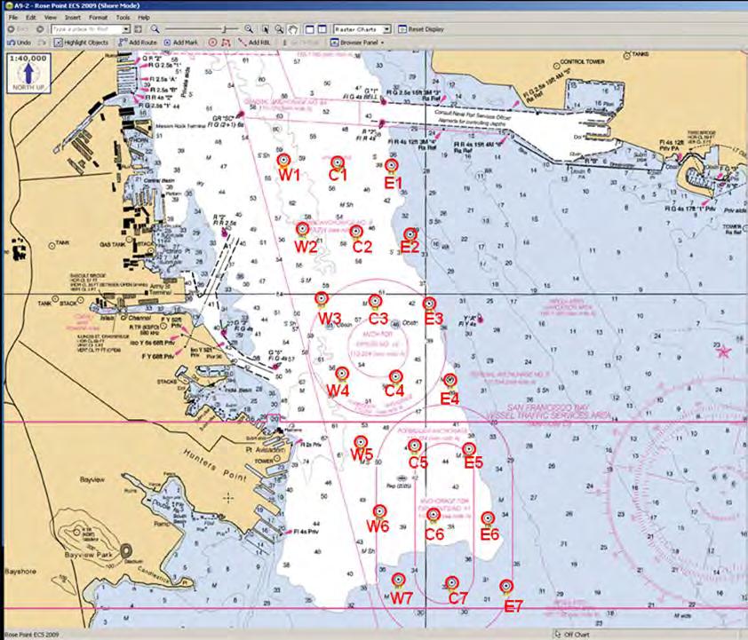
29 20 IV.

30 IV. Following successful implementation of the Anchorage 9 scheme, VTS adopted similar schemes for Anchorage 7 west of Treasure Island, and Anchorages 8 and 8A, west of the island of Alameda. Anchorage 7 can accommodate two vessels requiring temporary anchorage while waiting to proceed to pier facilities or other anchorage grounds. Vessels may not remain for more than 12 hours without COTP authorization, and must be prepared to move within one hour of notification by the COTP. No dangerous cargo or combustible liquids may be loaded unless authorized by the COTP. 21
 are intended for smaller, lighter draft vessels such as ATBs, Tug/Tow and USCG Cutters.")
31 IV. Anchorage 8 accommodates up to five vessels, though two smaller drop buckets with 0.2nm swing circles (8E1 and 8E2) are intended for smaller, lighter draft vessels such as ATBs, Tug/Tow and USCG Cutters. Anchorage 8A can accommodate a single vessel and is activated by VTS when additional space is needed. See Appendix A, Anchorages 7-9 Berthing Protocols, for coordinates. 22
32 V. V. Surveys, Charts and Dredging The rivers and streams that empty into San Francisco Bay carry large quantities of silt into the harbors and shipping channels of the Bay. Therefore, channel depths must be regularly maintained and shoaling controlled in order to accommodate deep-draft vessels. Beginning in 1868, Congress passed the River and Harbor Act and the federal government began dredging a channel to create a main ship channel in the approaches to San Francisco Bay. Maintenance dredging accounts for approximately 5,000,000 cubic yards of sediments dredged from the San Francisco Bay, Sacramento and San Joaquin ship channels annually. Actual channel depths may vary from project depths and must be checked with the most recent hydrographic surveys. Presently the project depth of the Main Ship Channel from the Pacific Ocean into the Bay is 55 feet deep and 2,000 feet wide. However, continual sedimentation flowing out of the river systems into the ocean reduces the Main Ship Channel from its authorized depths. According to the U.S. Army Corps of Engineers (USACE), there are no current plans to change the entrance channel s authorized width or depth. The depth of the main channel limits the draft of vessels able to enter the Bay. During the past century, the federal government deepened a number of shipping channels, removed several shoals and reduced rocks near Alcatraz Island. There are a number of federally dredged channels in the Bay, some of which are narrow. For example, Pinole Shoal is 600 feet wide and the Stockton Main Ship Channel is 200 feet wide. Bay Area ports and channels are maintained to various authorized project depths. (Consult the latest Coast Pilot 7 or NOAA charts.) Deep-draft vessels in the Bay are often constrained to navigate only within the main shipping channels. Groundings have been reported in many areas of the region, in part due to the narrow width of many of the channels. Groundings can result in damage to vessels and property, with the potential for serious environmental consequences. A ship aground in a channel can block the transit of other vessels or create new shoaling, and may cause serious delays to Bay commerce. Maneuvering deep-draft ships in narrow channels with minimal underkeel clearance poses high navigational risks, given the complexities of tides, currents and weather conditions in the Bay. 23
33 V. Surveys Surveys provide information on actual channel depths, reducing the risk of vessel groundings. The frequent shoaling and silting in the channels of San Francisco Bay and its tributaries require channel surveys to be conducted on a routine basis. Emergency surveys should be conducted when there is evidence that shoaling has occurred. Due to seasonal shoaling, some areas are surveyed on a more frequent basis. Even charts based on modern surveys may not show all seabed obstructions or shallow areas due to localized shoaling. The variable hydrodynamics of the Bay estuary are due to a number of factors such as drought and flood cycles, dredging projects and in-bay dredge disposal that may affect navigation channels. Strong seismic events may alter the bottom typography of the Bay due to liquefaction and lateral spread. Recent observations have indicated that manmade channels may be influencing tidal currents to a greater degree than anticipated, affecting sediment accretion. Accumulation of disposed dredged material at the disposal site near Alcatraz Island resulted in the need for a new approach to dredged material management, leading to adoption of the Long Term Management Strategy (LTMS) for the placement of dredged material in the San Francisco Bay region by the state and federal agencies that regulate dredging and disposal. The LTMS provides the basis for uniform federal and state dredged material disposal policies and regulations, with a focus on minimizing in-bay disposal of dredged material. Charts NOAA s Office of Coast Survey (OCS) designed a chart maintenance plan to provide support for the nation s largest commercial ports and trade routes. Selection of these ports and routes is based upon the tonnage and value of goods moving through them. Raster Chart Products: NOAA has been active in developing electronic chart products. NOAA s entire suite of 1,000 nautical charts is available in several formats for free download from the OCS website ( Print-on-Demand Charts (POD): Print-on-Demand (POD) hard copy paper charts are available for purchase from over a dozen certified vendors. An up to date list of NOAA certified POD product distributors is available on the Coast Survey website at: 24
34 V. San Francisco Bay NOAA Nautical Charts Chart Number Chart Scale Chart Title :207,840 San Francisco to Point Arena :100,000 Gulf of the Farallones :40,000 Entrance to San Francisco Bay :20,000 S.F. Bay: Candlestick Pt. to Angel Island :40,000 S.F. Bay: Southern Part :80,000 Small Craft Chart: S.F. Bay to Antioch :20,000 S.F. Bay: Angel Island to Pt. San Pedro :40,000 San Pablo Bay :10,000 Mare Island Strait :40,000 Suisun Bay :10,000 Carquinez Strait :10,000 Suisun Bay: Roe Island and Vicinity :10,000 Suisun Bay: Mallard Island to Antioch :40,000 San Joaquin River, Antioch to Medford I :40,000 Sacramento and San Joaquin Rivers :40,000 Sacramento River :20,000 Stockton Deep Water Channel :20,000 Sacramento to Colusa :210,668 Point Sur to San Francisco Vector-Based Charts: NOAA Continues to roll out vector-based Electronic Navigation Charts (ENC) suitable for Electronic Chart Display and Information System (ECDIS) platforms. The vector charts include active information on navigationally significant features such as aids to navigation, bridges, anchorages, obstructions, wrecks, rocks, cables, traffic separation schemes, pipelines, platforms, cautionary and dredged areas. The ENCs for the SF Bay region are compiled and available online at Hydrographic Surveys: USACE maintained channels are periodically surveyed by USACE. NOAA periodically surveys other areas of the Bay and its approaches. Specific hydrographic survey requests or concerns can be communicated to the Coast Survey California Navigation Manager. Contact information can be found online at 25
35 V. Navigational Issues Associated with Channel Design and Dredging Harding, Shag, and Arch rocks are large submerged rocks located approximately one to one-and-a-quarter nautical miles northwest of Alcatraz Island. The tops of the rocks are 35, 34, and 32 feet respectively below the surface of the water at MLLW. The submerged rocks are within the westbound traffic lane that passes north of Alcatraz Island and is designated for large vessels over 1,600 tons drawing 28 feet or less outbound to sea. Most inbound vessels sail south of Alcatraz Island; however, ships with a draft of more than 45 feet sail north of Alcatraz in the deep water traffic lane in order to maintain safe depths in the deeper waters within this area. Blossom Rock is 39 feet below the surface of the water at MLLW and is located approximately one nautical mile to the southeast of Alcatraz Island, posing a potential hazard to navigation for deep-draft vessels transiting Central San Francisco Bay. Harding, Arch, Shag and Blossom Rocks were lowered many decades ago for the shipping lanes, but today s large tankers and container ships have deeper drafts and now must avoid the submerged rocks. 26
36 VI. VI. Contingency Routing Dredging and construction may impact the routing of vessels in the Bay. Dredging of the shipping lanes is essential for safe navigation to the ports and marine terminals because so much of the Bay is shallow and subject to sedimentation. Therefore, maintenance dredging occurs on an ongoing basis. In addition, major projects to deepen various ports have taken place to accommodate the modern deep-draft vessels. The six major bridges that span San Francisco Bay shipping lanes require regular maintenance of bridge fender systems. In addition, there are projects to strengthen the supports of several bridges for the purpose of seismic safety. Maintenance and construction work on the bridges often impacts navigation lanes. During the many stages of a dredging or construction project that might impact the navigation of vessels, the project proponent and managers consult with pilots, vessel operators, the U.S. Coast Guard, affected port authorities and appropriate agencies. This ensures that consideration is given to the safety of navigation and any restrictions that may impact the movement of vessels. The USCG Vessel Traffic Service (VTS SF or VTS) has authority under the Ports and Waterways Safety Act to direct vessel movement in case of emergency to ensure the safety and security of the Port. The Captain of the Port has authority to create Safety Zones and to regulate vessel traffic in the event of an oil spill, disaster or emergency. San Francisco Vessel Mutual Assistance Plan (SF-VMAP). SF V-MAP is composed of member vessels, the Coast Guard, and passenger vessel operators who came together to develop an emergency response plan that would ensure a sufficient level of safety exists on small passenger vessels and enhance local capabilities to manage a catastrophic, waterborne Search and Rescue incident. Contingency Routing. Cooperation and consultation between pilots, the USCG, port authorities and appropriate agencies and contractors should continue from the project planning stage through the construction stage of projects that may impact safe navigation in the Bay. The planning stage should include an evaluation of various alternatives to ensure harbor safety. To reduce the risk of accidents occurring during harbor construction, dredging and waterway modification projects, the long-standing permitting procedures of the U.S. Coast Guard, the San Francisco Bay Conservation and Development Commission, the U.S. Army Corps of Engineers, the U.S. Environmental Protection Agency and the San Francisco Bay Regional Water Quality Control Board should be specifically referenced as mandates. 27
37 VI. Contractors are responsible for informing the USCG in advance of their planned and actual construction so that the USCG may advise and establish Safety Zones and/or provide cautionary notices and/or rerouting orders to mariners. A Safety Zone is a directive concerning a water area, a shoreline area or a combination thereof to limit access to authorized vessels. The Captain of the Port is authorized to establish temporary Safety Zones. Planning for alternate contingency routing during a construction project is not the responsibility of the Harbor Safety Committee. Project planning and construction are underway for seismic retrofitting of various major bridges in San Francisco Bay. These seismic retrofit activities will affect mariners on a daily basis for several years. The Coast Guard, with input from the Harbor Safety Committee, has worked with Caltrans, bridge owners and contractors to develop guidelines for construction activity on the bridges. Sector San Francisco, VTS and S.F. Bar Pilots will continue to review the plans for mooring construction equipment at bridge sites to ensure a safe path for navigation. Bridge owners are responsible for ensuring that reliable communications exist between the bridge, the VTS and transiting vessels so they can pass information about the location of construction equipment or other factors affecting navigation. The Eleventh Coast Guard District, Bridge Section provides information about bridge activities via telephone, letter, Local Notice to Mariners and Broadcast Notice to Mariners as appropriate. Mariners are reminded that heavy rain and high winter flows may result in reduced vertical and horizontal navigational clearances under bridges. Flotsam and drift may accumulate at bridge piers and abutments. Mariners should approach all bridges with caution and due consideration to existing navigational conditions. Notification of bridge-related discrepancies should be provided to the VTS via marine radio or telephone to ensure appropriate Notices to Mariners are issued. Construction, retrofit and maintenance activities at bridges involve the use of scaffolds, temporary trestles, and marine construction equipment. (See Appendix J, Vehicular Bridge Inventory.) General information about construction activities is provided in the weekly Local Notice to Mariners. Immediate information is provided by Broadcast Notice to Mariners and VTS advisories. Some projects have special considerations such as minimum wake or scaffolding that reduces vertical clearance. The Local Notice to Mariners and VTS provide contact information to the various work sites, allowing mariners access to timely information. Commercial vessels may be asked to provide their "air draft" and their vertical clearance requirement directly to the bridges or to VTS to assist the bridges in anticipating the need for moving scaffolding. Mariners are advised to transit the work site with minimum wake to ensure safe working conditions at the bridge. The cooperation of the maritime community during essential bridge work is appreciated.. 28
38 VII. VII. Vessel Speed and Traffic Patterns Ship Traffic A variety of commercial, military and public vessels enter, exit and transit the Bay. Many vessels such as ferries and tugs remain entirely within the Bay. Container ships, oil tankers and bulk carriers account for the greatest percentage of ship arrivals; however, a broad range of cargo transits the region every year. Other categories of ships include vehicle carriers, break bulk, chemical tankers and passenger ships. Occasionally, surface combatants, submarines and naval auxiliaries such as oil tankers and supply ships transit the Bay. Public vessels often encountered on the Bay include those of the U.S. Coast Guard, the Army Corps of Engineers, NOAA, and the Military Sealift Command. In order to safely transit the shipping channels to marine oil terminals in the North Bay and Carquinez Strait, some large oil tankers lighter oil to barges or to smaller ships. Lightering is the process of transferring oil from a larger ship tanker into smaller vessels to reduce the draft of the larger tanker. The large tanker can then proceed to a marine terminal and continue discharging the balance of its cargo. Lightering operations in the Bay take place in Anchorage 9 just south of the Oakland-Bay Bridge. The California State Lands Commission provides annual reports of the amount of oil shipped through the region (see Appendices). Speed of Vessels In the Central Bay, where vessel traffic is heaviest, vessels must navigate around Alcatraz Island and transit under the Bay Bridge to the Port of Oakland. Federal regulation 33 CFR Parts 162 and 165 became effective May 3, 1995 (see Captain of the Port Advisory # below). These regulations state in part that the maximum speed for all power driven vessels of 1,600 or more gross tons shall not exceed 15 knots through the water from the COLREGS Demarcation Line to the southern tip of Bay Farm Island, Alameda and the Union Pacific Railroad Bridge in Benicia. The regulations can be found on the web in the Code of Federal Regulations at This standard also applies to a tug with a tow of 1,600 or more gross tons. Power driven vessels of 1,600 or more gross tons shall in any case have their engines ready for immediate maneuver and shall not operate in control modes or with fuels that prevent an immediate response to any engine order ahead or astern or preclude stopping their engines for an extended period of time. 29
39 VII. Following the November 7, 2007 allision of the Cosco Busan container vessel with the San Francisco-Oakland Bay Bridge, the Navigation Work Group analyzed the facts of the incident to determine if amendments were needed to speed limitations in the Bay to improve navigation safety. After consideration, the Work Group found, and the HSC agreed, that existing speed limitations in San Francisco Bay are adequate. COTP Advisory # (4 May 1995): ENFORCEMENT OF NAVIGATION RULES IN SAN FRANCISCO BAY This advisory provides a listing of the major deep-draft channels in San Francisco Bay and adjacent waters which the Captain of the Port considers to be "narrow channels or fairways" within the meaning of the International and Inland Rules of the Road. Rule 9, in both the International and Inland Rules of the Road, establish requirements for vessels navigating in the vicinity of narrow channels or fairways. Vessels and powerboats less than 20 meters (approximately 65 feet), all sailboats and vessels engaged in fishing shall not impede the passage of a vessel that can safely navigate only within a narrow channel or fairway. Additionally, a vessel shall not cross a narrow channel or fairway if such crossing impedes the passage of a vessel that can safely navigate only within that channel or fairway. The term "shall not impede" means a small craft must keep well clear and not hinder or interfere with the transit of larger vessels. Small craft and fishing vessels shall not anchor or fish in narrow channels if large vessels or barges being towed are transiting. Coast Guard enforcement efforts, combined with a public education and information program, are further intended to draw public attention to the serious hazards created when smaller vessels impede large vessels. This effort should result in an improved level of navigational safety and reduce the risk of collisions, groundings and their potential consequences. The Captain of the Port considers the following areas to be "narrow channels or fairways" for the purpose of enforcing the International and Inland Rules of the Road. This list is not all-inclusive, but identifies areas where deep-draft commercial and public vessels routinely operate. Included in this list and marked by an asterisk (*) are the Regulated Navigation Areas (RNAs) in San Francisco Bay, which were designated in 33 CFR 162 and 165 (May 1995). The regulations can be found in the Code of Federal Regulations at a. All traffic lanes and precautionary areas in the San Francisco Bay eastward of the San Francisco Approach Lighted Horn Buoy SF (LLNR 360) to the San Francisco -Oakland Bay Bridge and the Richmond -San Rafael Bridge to include: 30
40 VII. *1. Golden Gate Traffic Lanes which include the Westbound and Eastbound Lanes west of the Golden Gate Precautionary Area. *2. Golden Gate Precautionary Area. *3. Central Bay Traffic Lanes, which include the Deep Water Traffic Lane, The Eastbound Lane (south of Alcatraz Island), and the Westbound Lane (south of Harding Rock). *4. Central Bay Precautionary Area. *5. North Ship Channel between North Channel Lighted Buoy "A" and the Richmond -San Rafael Bridge. *6. Southampton Shoal Channel including the Richmond Long Wharf maneuvering area. *7. Richmond Harbor Entrance Channel and the Point Potrero Reach ending at Point Potrero Turn and including the Turn Basin at Point Richmond. 8. Point Potrero Turn. 9. Richmond Harbor Channel in its entirety. 10. Santa Fe Channel in its entirety. *b. Oakland Harbor Bar Channel including the Outer Harbor Entrance Channel and the Inner Harbor Entrance Channel. c. Oakland Outer Harbor. d. Oakland Inner Harbor from Inner Harbor Channel Light "5" (LLNR 4670) to, and including, the Brooklyn Basin South Channel. e. Alameda Naval Air Station Channel in its entirety. f. South San Francisco Bay Channels between the central Bay Precautionary Area and Redwood Creek Entrance Light "2" (LLNR 5180). g. Redwood Creek between Redwood Creek Entrance Light "2" (LLNR 5180) and Redwood Creek Day-beacon "21" (LLNR 5265). *h. San Pablo Straight Channel from the Richmond-San Rafael Bridge to San Pablo Bay Channel Light "7" (LLNR 5900). *i. Pinole Shoal Channel in San Pablo Bay between San Pablo Bay Channel Light "7" (LLNR 5900) and San Pablo Bay Channel Light "14" (LLNR 5935). j. Carquinez Strait between San Pablo Bay Channel Light "14'.' (LLNR 5935) and the Benicia-Martinez Highway Bridge. k. Mare Island Strait between Mare Island Strait Light "2" (LLNR 6095) and Mare Island Causeway Bridge. l. Suisun Bay Channels between the Benicia-Martinez Highway Bridge and Suisun Bay Light "34" (LLNR 6655). 31
41 VII. m. New York Slough between Suisun Bay Light "30" (LLNR 6585) and San Joaquin River Light "2" (LLNR 6670). n. Sacramento River Deep Water Ship Channel from Suisun Bay Light "34" (LLNR 6655) to the Port of Sacramento. o. San Joaquin River from San Joaquin River Light "2" (LLNR 6670) to the Port of Stockton. Rules of the Road Enforcement: Timely reporting and enforcement of Rules of the Road infractions promotes safer navigation. Vessel masters, pilots, and operators are encouraged to report incidents, which merit investigation. Reports will be fully investigated and may result in license suspension or revocation proceedings or the assessment of civil penalties. 32
42 VIII. VIII. Accidents and Near-Accidents Accidents. The Coast Guard compiles reports of marine accidents or reportable casualties of commercial, military and recreational vessels. A reportable casualty is defined in Title 46, Code of Federal Regulations, Part 4 (46 CFR ). The regulations can be found on the web in the Code of Federal Regulations at Reporting Requirements. The regulations can be found on the web in the Code of Federal Regulations at Analysis and Actions Taken to Alleviate Accidents. Major bridges span shipping channels, connecting various populated areas of the Bay. The bridges are important traffic connectors under which large vessels must carefully navigate between spans. Vessels have struck all Bay bridges during the past 25 years, resulting in damage to the vessels and/or the bridges. Radar beacons (racons) have been added to most of the region s bridges to enhance the vessel operator s ability to safely navigate between bridge spans in all types of weather. In 1992, the Harbor Safety Committee recommended that the Coast Guard and VTS devise a more consistent system of reporting accidents and near-accidents, standardized with other areas, and to analyze the statistics on an annual basis with recommendations for improvements. This recommendation has been essentially accomplished in San Francisco Bay. As part of this effort, the Harbor Safety Committee worked for adoption of a statewide definition of near-miss. The following definition was adopted by the five California Harbor Safety Committees: A reportable Near-Miss Situation is an incident in which a pilot, master, or other person in charge of navigating a vessel, successfully takes action of a non-routine nature to avoid: a collision with another vessel, structure or aid to navigation; the grounding of a vessel; or damage to the environment. 33
43 VIII. The HSC also participated in establishing a system for voluntary reports of near-miss situations for the Coast Guard in order to prevent vessel accidents. A voluntary reporting form was adopted and included in the Vessel Traffic Service, San Francisco, June 1995 User s Manual. In addition, the Captain of the Port included the report form in the Marine Safety Office newsletter, and the San Francisco Bar Pilots Association made the report form available to its members. However, due to the Freedom of Information Act, the Coast Guard determined that anonymity could not be provided to persons making reports. The USCG considered a program to address near-misses (or non-reportable near casualties); however, the program was put on hold in November 2002 due to a lack of funding. 34
44 IX. IX. Communication Radio Communications Ship-to-ship and ship-to-shore communication for the maritime community in the San Francisco Bay Area is almost exclusively on marine VHF (very high frequency) radio. The level of usage varies with periods of saturation depending on the time of day and level of vessel traffic. Additional communication modes include telex, fax, internet, cell phones and AIS (Automatic Identification System) messaging. VHF radio is expected to continue as the primary method for ship-to-ship and ship-toshore radio communications. Cell phones help to amplify or clarify information that would not normally be passed, or would be limited, over VHF radio. Nonetheless, cell phones are not a substitute for VHF radio as the primary means of communication with and between vessel traffic in the Bay Area. AIS helps mariners to more quickly identify other vessels thereby reducing the duration and number of radio transmissions. Please see Chapter XXI for brochures that address radio communication and safe vessel operations available from the San Francisco Marine Exchange. Current Usage CHANNEL USE SAN FRANCISCO BAY COMMON FREQUENCY USAGE 06 Intership safety. Also often used for non-distress traffic between USCG and other vessels. 10 San Francisco Bar Pilots Pilot Boats Agents San Francisco Marine Exchange Chevron Richmond Long Wharf 12 Vessel Traffic Service San Francisco offshore traffic. Used between outer limit of Offshore Precautionary Area and VTS outer limit (38 nautical mile radius from Mt. Tamalpais). 13 Bridge to bridge navigation 14 Vessel Traffic Service San Francisco in-shore traffic. Use from outer limit of Offshore Precautionary Area, throughout San Francisco Bay, up to Stockton and Sacramento. 16 Hailing/distress/safety. 21A U.S. Coast Guard reserved working frequency between USCG units only. 22 Notice to Mariners 35
45 IX. CHANNEL 23A 7A, 11, 77 18A, 19A 79A, 80A, 88A 7A, 8, 9, 11, 18A, 19A 9, 68, 69, 71, 72, 78A USE U.S. Coast Guard and public working channel USCG reserved working frequency for communications between USCG units and other vessels. Common tug working frequencies. Commonly used by fishing vessels. Port Operations Commercial intership and ship to shore working channels. Commercial vessel business and operational needs. Port Operations Non-commercial; supplies repairs, berthing, yacht harbors/marinas. TUG COMPANY CHANNELS 9 Westar Marine Services 10 Crowley Marine Services Foss Maritime Company 18A AMNAV Maritime Services Baydelta Maritime Brusco Tug & Barge Oscar Niemeth Towing SeaRiver Maritime Seaway Towing Company Starlight Marine Services MARINE OPERATORS 26, 84, 87 San Francisco 27, 28, 86 Sacramento, Stockton, Delta VESSEL TRAFFIC SERVICE RADIO COVERAGE VTS has complete radio coverage throughout the region on its designated frequencies. Existing Limitations Due to the many hills in the region that restrict line of sight, VHF Channel 13 has a number of blind spots because of the one-watt transmission limitation on the channel. Equipment 1. San Francisco Vessel Traffic Service (VTS). VTS communications equipment consists of four remote sites located throughout the region that ensure complete VHF radio coverage of the VTS area. 36
46 IX. 2. San Francisco Bar Pilots. The San Francisco Bar Pilots headquarters is located at the East end of Pier 9, San Francisco. The antenna for their primary system is located on Mt. Tamalpais. 3. San Francisco Marine Exchange. The Marine Exchange is located at 505 Beach Street in San Francisco. The Exchange shares the antenna on Mt. Tamalpais with the Bar Pilots. Their communication equipment includes: A 50-watt transceiver on Channel 10. A standard transceiver with a local antenna monitoring Channels 13, 14, & 18A. Marine Exchange Communication System The San Francisco Marine Exchange, a non-profit agency that serves as the Clearing House for tug escorting of regulated tankers and barges, has backup battery systems and generating capacity for its computer, phone, and radio systems. 37
47 X. X. Bridges The San Francisco Bay Area is crossed by a number of bridges that carry automotive and rail traffic. Most shipping traffic transits through moveable or fixed bridges with adequate vertical clearance for normal passage. Geographic Boundaries The boundaries of the area in this chapter are set in the West by the COLREGS Demarcation Line (Between Pt. Bonita and Mile Rocks), and in the East to include the Rio Vista Highway Bridge in the Sacramento River and the Antioch Highway Bridge in the San Joaquin River. Schedule of Bridge Openings Oceangoing vessels may transit under two vertical lift bridges, the Benicia-Martinez Railroad Drawbridge and the Rio Vista Highway Drawbridge. Both bridges are operated 24 hours a day and open for vessel traffic upon request. Approximately 30 minute notice is beneficial and the bridges may be contacted by VHF or telephone. For vessels intending to transit through the Benicia-Martinez Railroad Drawbridge, there is a well-established protocol for requesting a lift. Copies of the protocol are available at the VTS website, BRIDGE VHF CHANNELS PHONE NUMBER Benicia-Martinez RR Bridge 13 (925) Rio Vista 9, 13, 16 (707) Adequacy of Ship-to-Bridge Communications Ship to bridge communications takes place via VHF radio on designated channels or as required by drawbridge regulations (Title 33 CFR 117). Communications are considered to be adequate by the local maritime community. 38
48 X. Physical Characteristics of Bridges When required by the Eleventh Coast Guard Bridge Office, under the provisions of Title 33 Code of Federal Regulations, Part 118, bridges over navigable waterways in the Eleventh Coast Guard District, are lighted and marked as permitted obstructions on the waterway. Standard markings include a range of two green lights marking the center of the bridge, which in the case of drawbridges, will shift from green to red when the drawspan is in anything but the full open-to-navigation position. Bridge piers in or adjacent to the navigational channel may be lighted at night with fixed red lights to identify them as obstructions. When required, bridges are equipped with sound producing devices that are used during periods of reduced visibility. The region now has 12 Racons mounted on bridges. A racon is a radar sensor (radar beacon) that sends out a radar emission that shows up as a distinctive mark on a ship s radarscope. The racons were installed because there is a high volume of vessel traffic transiting under bridges and the Bay Area has the highest number of foggy days in the nation when visibility is less than one-half mile. Racons are located on the following Bay Area bridges: Benicia-Martinez (1) SF-Oakland Bay Bridge (3) Richmond-San Rafael Bridge (2) San Mateo-Hayward Bridge (1) Antioch Bridge (1) Rio Vista Bridge (1) Golden Gate Bridge (1) I-80 Crocket-Vallejo (2) Bridge Clearances (See Appendices for most recent list of bridge clearances.) Benicia-Martinez Railroad Drawbridge To improve navigational safety for all vessels sailing through the relatively narrow opening of the drawbridge at Benicia, the Coast Guard has completed a number of initiatives: Established a Regulated Navigational Area (RNA) at the bridge, which prohibits deep-draft vessel transits when visibility is less than 1000 yards. The Coast Guard revised the RNA to change the name of the bridge to the Benicia-Martinez RR Bridge, added a third visibility checkpoint, and clarified the procedures for downbound vessels that are moored or anchored between the Railroad Drawbridge and New York Point (that intend to transit the RNA once underway). 39
49 X. Installed white lights on the main channel piers to better identify the primary navigation channel. The white pier lights recommended for installation on the main channel piers have provided better visibility in foggy conditions and have been made permanent. Asked the Union Pacific Railroad (UPRR) to change the working frequency of the bridge radiotelephone to VHF Channel 13, to allow vessels and bridge operators to communicate directly instead of using Vessel Traffic Service Channel 14. This change went into effect in Investigated bridge malfunctions and created natural working group to find solutions to process and equipment problems. Had Caltrans make modifications to the RACON on the adjacent highway bridge, which has improved the signal to downbound vessels. Most of the recommended bridge improvement items have been completed by UPRR. UPRR has installed a new auxiliary power system including a new generator and transformers, along with a new signal system. New enhancements include replacement of the bridge lift motors, installation of a computerized system to monitor train locations and track conditions and a computer system to track vessels upbound or downbound for the bridge. To preserve the solutions implemented as a result of the natural working group ( ), concerning the operation of the Benicia-Martinez Railroad Drawbridge, rail and waterway industry representatives and the Coast Guard continue to meet semi-annually to discuss problems with the bridge and to develop solutions. In addition to the elimination of near miss ship events with the bridge, there has been a significant reduction in rushhour commuter rail and Amtrak traffic delays, due to the coordination by the SF Bar Pilots to make minor adjustments in ship arrival times at the bridge, when possible, to avoid impacting scheduled commuter rail traffic. 40
50 XI. Small Passenger Vessels Ferries XI. Small passenger vessels (ferries) operate year round on San Francisco Bay, San Pablo Bay and their tributaries, carrying nearly six million passengers on 240 transits per day. In total, passenger vessels made up nearly 60 percent of all transits tracked by the San Francisco USCG Vessel Traffic Service (VTS) annually. Other ferries carry tourists and dinner cruises year round in the Central Bay. In 2007, the state legislature established the San Francisco Bay Area Water Emergency Transportation Authority (WETA), as a regional agency with responsibility to develop and operate a comprehensive Bay Area public water transportation system and to coordinate the emergency response of waterborne transit. WETA is charged with coordinating emergency response activities for water transit services in cooperation with MTC and other agencies, consistent with the provisions of July 2009 Emergency Response. In June 2012, WETA launched its first new ferry route connecting South San Francisco s Oyster Point Marina and Oakland s Jack London Square. WETA carries more than 1.9 million passengers annually on a fleet of 12 high-speed ferry vessels, serving the cities of Alameda, Oakland, San Francisco, South San Francisco and Vallejo. Because of concerns associated with an increasing number of commuter ferries sharing the Bay with large shipping vessels and recreational boaters, the HSC requested the Ferry Operations Work Group develop an approach and maneuvering scheme in the vicinity of the congested San Francisco Ferry Building, as well as a routing protocol in the Central Bay to decrease the risk of collision for commute ferries. The routing was adopted by the HSC in 2008, and is included at the end of this chapter. Small Passenger Vessel Services Small passenger vessels are defined as less than 100 gross tons that are inspected and certified by the U.S. Coast Guard to carry passengers for hire. T vessels carry fewer than 149 passengers, K vessels carry more than 149 passengers. One H vessel (larger than 100 gross tons) is based in San Francisco. Note: This overview is meant to describe larger private and public vessel operators and does not include the sport fishing or smaller vessel operators that meet the definition of small passenger vessel. Ferry: Regularly scheduled, operate year round, and provide point-to-point service. Regularly-Scheduled and Excursion: Seasonal and year round scheduled service, including sightseeing tours, dining, and/or entertainment. 41
51 Geographical Scope. Ferry routes bring passengers from outlying cities in the region to the city of San Francisco. Excursion routes operate primarily in the central San Francisco Bay. The following are small passenger vessel terminal locations as of June 2012: San Francisco Downtown Ferry Terminal Fisherman s Wharf, San Francisco San Francisco China Basin Ferry Terminal Oyster Point, South San Francisco Larkspur Terminal Gateway Alameda Clay St. Oakland Harbor Bay Isle, Alameda Vallejo, Mare Island Sausalito Tiburon Small passenger vessels also operate on an unscheduled basis out of marinas in Sausalito, Alameda, Oakland and Berkeley. Small Passenger Vessel Safety Program U.S. Coast Guard San Francisco Vessel Mutual Assistance Plan. The purpose of the San Francisco Vessel Mutual Assistance Plan (SF V-MAP) is to ensure that a sufficient level of safety exists. It is intended to enhance local capabilities to effectively manage a catastrophic, in port Search and Rescue incident. The objectives of the SF V-MAP are to: 1. Create a sufficient level of safety as required by 46 CFR (f). 2. Provide effective and expedient emergency support by member vessels for a marine search and rescue operation on San Francisco Bay involving a large number of victims or potential victims. 3. Ensure lifesaving equipment available on each member vessel is appropriate for the waters of San Francisco Bay. 4. Promote professionalism in emergency preparedness and response. 5. Provide, through mutual assistance, a more effective and timely means to rescue all persons in the water (PIW). XI. 42
52 Best Practices XI. S.F. Bay Area ferry operators participated in the Harbor Safety Committee Ferry Operations Work Group to develop common best maritime practices for safe passenger vessel operation in the Bay. San Francisco Bay Area Ferry Operation in Inclement Weather. As described in the Harbor Safety Plan, localized microclimates can alter visibility along an entire route or a portion of a route. During summer, channel fog is prevalent in the central San Francisco Bay with outer areas clear. In winter months Tule fog can be widespread, dense in the morning with clearing later in the day. The Master of a ferry is the person in charge of the vessel, responsible for the safety of the passengers and crew at all times, and has the authority to decide if it is safe to get underway or to proceed. In reduced visibility and inclement weather conditions, the following practices are followed: A go or no-go decision to get underway is made by the vessel Master or the company Operation Manager, based on conditions along the entire route, using all available information including the experience of the Master and operations manager. Look-outs: the vessel Master assigns crewmembers for look-out duty based on the existing or anticipated conditions; the applicable regulations are found in the Navigation Rules and Regulations, Rule 5 Look-out (text attached). Safe speed: the vessel is required to proceed at a speed appropriate to the prevailing circumstances and conditions, which include state of visibility and the manageability of the vessel with special reference to stopping distance and turning ability. Other factors include participation in fixed ferry routes, wind advisories issued by NOAA, sea state, traffic density, and applicable Navigation Rules and Regulations (see attached verbiage from Rule 6 Safe Speed). Equipment: each ferry is required to have at minimum one radar; commuter ferry vessels generally have two operational radars onboard; the vessel Master is required to have a radar observer license endorsement. Global Positioning Satellite, Automatic Identification System and Electronic Charting navigation systems are also installed and used to assist navigation. In conditions of high wind and waves: 43
53 Go/no-go decision is made by the vessel Master or the company Operation Manager, based on conditions along the entire route, using all available information including the experience of the Master and operations manager. Factors to be considered include size of the vessel, direction of the winds and seas, orientation of departure and arrival piers to prevailing conditions, and limitations of ferries to travel at slower speeds. Passenger safety: Captain can maneuver the vessel to minimize wave effects. Crew duties include rough weather announcements and passenger safety management. XI. High Speed Ferry Operations (over 30 Knots). U.S. Coast Guard Navigation and Vessel Inspection Circulars (NAVIC) 5-01 and 5-01 Change 1 provide specific guidance for high speed passenger vessels and include approved vessel operation manuals, training programs and risk assessment tools (matrix). Vessel equipment: operators have exceeded minimum requirements for navigation electronics including dual radar, Global Position Satellite and electronic charting with Automatic Identification System overlay. Manning/Training: Vessels traveling at high speed are required to have a minimum of two qualified watch-standers during normal operations. Vessel operators have developed approved training programs for high speed navigation in compliance with NAVIC 5-01 and 5-01 Change 1. Ferry Traffic Routing Protocol The Ferry Traffic Routing Protocol consists of planned routes and communications procedures for improving ferry navigation safety. When ferries follow routes, the Closest Point of Approach (CPAs) with other ferries is greatest at points where speeds are typically greatest. The adopted routes cross at predetermined locations at nearly right angles, enabling ferries to predict crossing situations and plan ahead. Within an approximately one-half nautical mile zone around the San Francisco Ferry Building, the protocol calls for port-to-port meeting and heightened radio communications. For inbound Ferry Building ferries, the protocol requires planning far enough in advance to avoid getting within approximately one-half nautical mile from the Ferry Building if another ferry is still at the inbounder s dock. This reduces crowding around the Ferry Building. With ferry routes charted on nautical charts, other types of vessels can more easily predict the locations of ferries and steer clear. The Ferry Traffic Routing Protocol supports aggressive use of electronic nautical charts (ENCs) with intergraded Automatic Identification System (AIS). When all ferries consistently update their AIS data and follow routes, the protocol will ultimately lead to reduced VTS-ferry communications. 44
54 Ferry routes and the Ferry Building Approach Zone are shown in Appendix A and are incorporated herein. Water Taxis In response to increasing congestion on the Bay Bridges and land-based public transit, smaller vessels carrying fewer than 49 passengers and crew are approved to operate between Berkeley and other East Bay stops to San Francisco and Redwood City. These routes are not included among the current ferry routes. However, it is expected that these vessels will broadcast an AIS signal to identify their transits, maintain communication with other vessels via VHF channels 13 and with VTS on channel 14 when necessary. Also, as agreed during a Ferry Work Group meeting in early 2017, water taxis will operate clear of the High Speed Ferry Protocol lanes and cross these lanes as close to 90 degrees as possible. As timetables and frequency of Water Taxi service continues, modifications to safety protocols may be adopted. XI. 45
55 XII. Small Vessels XII. Background Within the Bay, many recreational boats and commercial fishermen transit navigational shipping lanes and some approaches to port and marine terminal facilities. The central part of the Bay, with the heaviest concentration of population in close proximity to the shoreline, has the largest number of small boat marinas along the San Francisco, Alameda, Contra Costa, and Marin County shorelines. Two-thirds of approximately 20,000 Bay Area marina berths are located in the Central Bay. This number does not include facilities on the Sacramento and San Joaquin Rivers. The last Sunday in April (Opening Day on the Bay), Memorial Day, Labor Day, Independence Day and Fleet Week are times of extreme congestion by small vessels. There are many occasions where six or eight races may be held in the same venue, with vessels starting at five-minute intervals. This may lead to more racing congestion than a single large popular regatta. Race instructions now carry a warning regarding interference with large vessels. Motorized vessels occupying berths in the Bay area constitute only 15 percent of registered vessels using the Central Bay. Numerous boat ramps and launches encourage use of the Bay by smaller motorized vessels and increasingly popular non-motorized vessels such as canoes, kayaks, windsurfers and paddleboards. While only a percentage of boat owners and renters are on the Bay at any given time, sunny weekends may bring thousands of pleasure boat users on the Bay's waterways. Coast Guard, commercial ship, tug and ferry operators note that small craft are difficult to spot in periods of limited visibility, and present a poor or non-existent image on radar. Because of the limited navigable channels in the Bay, small craft may constitute a hazard to navigation. In addition to the Bay s commercial fishing fleet, comprising approximately 1,000 boats, charter boats carrying numerous fishermen also fish the Bay and areas west of the Golden Gate Bridge. However, of this number, about 150 to 200 boats, principally berthed in San Francisco, Sausalito and Oakland, are used full-time for commercial fishing. Many of the licensed commercial fishermen are part-time operators, fishing on weekends and holidays by trailering small boats to launch ramps. In the Bay the only commercial fish caught are herring, anchovies and halibut, with herring the most important in-bay fishery. During the December to March herring season, additional boats from other areas enter the Bay to lay their nets. The State Department of Fish and Wildlife controls the number of boats fishing in the Bay during the herring season and regulates the manner of fishing. 46
56 Vessel Traffic Incidents XII. Sail and motor boats. Thousands of recreational boats are concentrated near the major inbound and outbound Bay shipping lanes. While many sailboats and motorboats are on the Bay, particularly on weekends, few near-misses or accidents are reported to the Coast Guard or Vessel Traffic Service. A number of reported and unreported near-misses may be prevented by small boats properly yielding the right-of-way to large vessels that cannot change course. Kayaks, sail and paddle boards. A number of near-misses have been reported to the HSC by passenger ferry and cargo vessel operators over the past several years. Tragically, a fatality occurred in 2011 when a paddler was swept out of his kayak and never found when he tried to ride the prop wash of two operating tugs along the San Francisco waterfront. Also reported, a number of board sailors cross in front of tankers and container ships off Crissy Field, which is close to the Golden Gate Bridge. Competitive races are sponsored at this location throughout the year. Paddle boarders and kayakers attempt to traverse the Oakland Estuary turning basin while tugs are moving large container ships in the confined area. Fishing boats. Many commercial and recreational fishermen have worked side by side with inbound and outbound ship traffic plus in-bay vessel traffic for many years. Once commercial fishing gear is set in an area, it will remain in that location for a period of time. Subject to winds and tides, the gear may move in directions the fisherman may not have intended. Since this may create an obstruction, a warning regarding possible interference with other vessels should be made to VTS. The following boater education programs are available to the boating public in the nine Bay area counties. U.S. Power Squadrons U.S. Coast Guard Auxiliary California Dept. of Boating and Waterways Courses.aspx National Association of State Boating Law Administrators Subjects Boating Safety Rules of the Road, Basic Rescue Boating Safety Rules of the Road, Basic Rescue Water Safety/Grades K 12, General Variety of courses In addition, the U.S. Coast Guard has a website dedicated to promote boating safety: 47
57 Mandatory boater education and licensing in California is slated to begin in 2018, affecting only boat operators under 20 years of age. XII. USCG-mandated Rule 9 applies to all vessels, and is enforced in California by various local agencies such as Sheriff's patrols, as well as USCG. RULE 9 places the obligation on the small [under 20 meters] vessel operator to avoid impeding a large vessel while operating in a deep draft channel or fairway. Rule 5 states: "Every vessel shall at all times maintain a proper look-out by sight and bearing as well as by all available means appropriate to the prevailing circumstances and conditions so as to make a full appraisal of the situation and of the risk of collision." 48
58 XIII. XIII. Vessel Traffic Service The U.S. Coast Guard established the Vessel Traffic Service (VTS SF or VTS) in San Francisco Bay in 1972, following a serious collision between two tank vessels that resulted in great environmental damage to the Bay. The Coast Guard continues to operate the VTS system and monitors nearly 400 vessel movements per day. The region is considered a difficult navigation area because of its high-traffic density, frequent episodes of fog and challenging navigational hazards. In 1996 Congress considered reducing the current level of funding for VTS SF. In response, the Harbor Safety Committee voted to support continued federal funding to maintain VTS SF at its current level in order to ensure navigational safety in the Bay. The VTS for the San Francisco Bay region has six components: (1) Automatic Identification System (AIS), (2) radar and visual surveillance, (3) VHF communications network, (4) a position reporting system, (5) traffic schemes within the Bay, and (6) a 24- hour center that is staffed with specially trained vessel traffic control specialists. The geographic area served by VTS SF includes San Francisco Bay, its seaward approaches, and its tributaries as far as Stockton and Sacramento. VTS Mission The primary mission of VTS San Francisco is to coordinate safe, secure and efficient transit of vessels in San Francisco Bay, including its approaches and tributaries, in an effort to prevent accidents or terrorist actions, which could result in loss of life, damage to property or the environment. VTS implements and enforces the portions of the Ports and Waterways Safety Act that enhance navigation, vessel safety and marine environmental protection and promote safe vessel movement, by reducing the potential for collisions, allisions and groundings, and the loss of lives and property associated with these incidents. VTS provides the mariner with information related to the safe navigation of a waterway. This information enhances the safe routing of vessels through congested waterways or waterways of a particular hazard. Under certain circumstances, VTS may issue directions to control the movement of vessels in order to minimize the risk of collision between vessels, or damage to property or the environment. The owner, operator, charterer, master or other person directing the movement of a vessel remains at all times responsible for the manner in which the vessel is operated and maneuvered and is responsible for the safe navigation of the vessel under all circumstances. 49
59 VTS Authority XIII. VTS regulatory authority comes from 33 CFR 161 Vessel Traffic Service Regulations. These regulations give VTS the authority to manage, control or direct vessel traffic within the VTS area. VTS may issue measures or directions to enhance navigation and vessel safety and to protect the marine environment, including, but not limited to: 1. Designating temporary reporting points and procedures; 2. Imposing vessel operating requirements; or 3. Establishing vessel traffic routing schemes. The regulations can be found on the web in the Code of Federal Regulations at During conditions of vessel congestion, restricted visibility, adverse weather, or other hazardous circumstances, VTS may control, supervise, or otherwise manage traffic, by specifying times of entry, movement, or departure to, from, or within a VTS area. Participation is required for all vessels that fall under the Bridge-to-Bridge Radio Telephone Act. Active participation (through a series of reports) is required for all vessels that fall under the Vessel Movement Reporting System (VMRS), defined as: powerdriven vessels 40 meters in length or greater; tugs, 8 meters or greater while towing; and passenger vessels certificated to carry 50 or more passengers for hire. Through the exchange of vessel transit information, VTS provides vessel operators with up-to-date information, thereby facilitating safe transits for vessels interacting on the waterways. VMRS Reporting Requirements Sailing Plan Report Unless otherwise stated, at least 15 minutes before navigating a VTS area, a vessel must report the: (a) Vessel name and type; (b) Position; (c) Destination and ETA; (d) Intended route; (e) Time and point of entry; and (f) Dangerous cargo on board or in its tow, as defined in 33CFR
60 Position Report XIII. A vessel must report its name and position: (a) Upon point of entry into a VMRS area; (b) At designated reporting points as set forth in subpart C; or (c) When directed by the Center. Note: Vessel position reporting requirements vary depending on a vessel s ability to transmit AIS information to VTS. Sailing Plan Deviation/Amplification Report A vessel must report: (a) Any significant deviation from its Sailing Plan or from previously reported information; or (b) Any intention to deviate from a VTS issued measure or vessel traffic routing system. Final Report (FR). A vessel must report its name and position: (a) On arrival at its destination; or (b) When leaving a VTS area. Offshore. Vessels are required to make radio reports on VHF Channel 12 when entering or exiting the offshore VTS reporting area, which extends approximately 30 miles west from the Golden Gate Bridge. Inbound vessels are required to report 15 minutes prior to crossing the offshore boundary, upon entering the respective Traffic Separation Scheme (TSS), and upon entering the precautionary area. Outbound vessels are required to report once at the San Francisco Sea Buoy, again at the TSS entrance buoy, at the terminus of the TSS and finally at the outer boundary of the VTS area. Radio reports include the name and type of vessel, route, course, speed, position and estimated times of arrival to various geographic locations. The VTS broadcasts a traffic report every 30 minutes: at minute 15 and 45 of each hour. 51
61 XIII. Within the Bay. Vessels report 15 minutes prior to and upon getting underway, docking, mooring, or anchoring or when departing from the VTS area. Position reports are also made when passing under most bridges, when pilots change, when emergencies arise and when deviating from standard procedures. Ferries operating on a scheduled route make one report prior to departure, and do not report again unless they deviate from their schedule or route. Traffic Routing within San Francisco Bay On May 3, 1995, the Coast Guard established seven Regulated Navigation Areas (RNAs) to reduce vessel congestion where maneuvering room is limited. These RNAs apply to the waters of the Central Bay, Oakland Harbor, San Pablo Bay, and the Benicia-Martinez Railroad Bridge. There are four VHF radio/communications sites located throughout the Bay which give VTS full radio coverage. VTS operates on channel 14 VHF for inshore traffic and channel 12 for offshore traffic, and monitors channel 13 throughout the VTS area. VTS Training Program Overview VTS Operators undergo extensive training. Before these traffic management specialists begin on-the-job training in the Operations Center, they undergo three months of intensive training at the VTS in the classroom and self-study, plus up to three weeks of offsite training. Offsite training typically includes a two week National VTS Certification course and a one-week Nautical Rules Course. All training is tailored to the individual needs of the trainee. After this initial classroom and self-study period, new Operators/Traffic Management Specialists then undergo three to four months of closely supervised on-the-job training. This training cycle can be shortened if the person has previous VTS experience; however, the average time for a new employee to become qualified in their primary job is six months. New supervisors can take an additional two to three months before qualification. Outreach and Partnership The San Francisco Bar Pilots and the U.S. Coast Guard Vessel Traffic Service San Francisco, as well as other members of the maritime community, continue to share professional information in order to foster a team approach to the issue of navigation safety within the San Francisco Bay Area. VTS participates in the following outreach and partnership programs: 52
62 XIII. VTS-Pilots Issue Committee (VPIC). Founded in 1995, the VPIC comprised of the VTS Director, Operations Center Supervisor, Training Coordinator and members of the San Francisco Bar Pilots meets as needed to discuss how VTS and the Bar Pilots can better serve each other. Both agencies might bring in scenarios or review recordings, then discuss the interactions from their respective points of view. For example, VTS may explain why a particular deviation request from RNA regulations was not granted. With the VPIC interaction, VTS can explain the response from a VTS perspective, and the pilots can then explain why a requested deviation seemed safer from the pilot s point of view. In addition to providing a forum for discussion, VPIC has produced an anchorage berthing protocol, the development of a communication protocol to resolve communication issues around marine construction projects, and the refinement of reporting procedures in order to provide mariners with more accurate reports of ongoing marine construction in the Bay area. San Francisco Vessel Mutual Assistance Plan (SF-VMAP). SF-VMAP is composed of member vessels, the Coast Guard and passenger vessel operators who came together to develop an emergency response plan that would ensure that a sufficient level of safety exists on small passenger vessels and enhance local capabilities to manage a catastrophic, waterborne Search and Rescue incident. VTS was active in the creation of this plan and continues to participate in annual drills and meetings. The San Francisco Marine Exchange is working in partnership with the Coast Guard to perform the administrative requirements of SF-VMAP. Outreach. VTS personnel spend many hours with people from various segments of the San Francisco Bay maritime community to learn about mariners concerns and to educate mariners on how VTS can assist them. VTS personnel have been active participants on the Prevention through People Work Group, the Tug Escort Work Group, the Ferry Operations Work Group and the Navigation Work Group. Outreach efforts also have included many non-traditional stakeholders in the Bay area, such as the California Department of Transportation bridge engineers responsible for overseeing the various seismic retrofit projects in progress throughout the Bay. VTS personnel also assist with USCG outreach in preparation for commercial fishing seasons. Marine Events. San Francisco Bay has more permitted marine events than any other port or city in the United States. VTS has an active outreach program to the boating public, which includes meeting with various recreational boating organizations throughout the year. VTS works closely with other Coast Guard personnel and yachting organizations during the permit process to prevent recreational vessels from impeding commercial traffic. The Coast Guard hosts annual Marine Event Workshops aimed at educating event coordinators about commercial maritime traffic, Rule 9 of the Navigation Rules and VTS operations. 53
63 XIII. VTS Ship Ride Program. All VTS personnel are required to participate in approximately six ship rides and/or shore-side visits each year. This, by far, is the best method for direct, person-to-person contact with port stakeholders and the sharing of suggestions. The requirements cover almost all areas of the maritime community: piloted ships, tugs, ferryboats and shore facilities. VTS Operations and Requirements Over the years since the inception of VTS San Francisco, the Coast Guard has periodically identified the need for upgrading VTS equipment to include state-of-the-art technology. VTS system of tracking vessels by computer was initially installed in In 2000, the software and hardware were upgraded, and a renovation of VTS communications system was completed. This communication system upgrade involved replacing radios at each of the VTS high sites, converting them from an analog to a digital microwave system and installing a new radio control system. In December 2004, VTS was upgraded with Automatic Identification System antennas and software. 54
64 XIV. XIV. Tug Escort / Assist for Tank Vessels The following section provides a history of the evolution of Tug Escorting for Tankers within San Francisco Bay with some updated information. Current requirements pertaining to escort tugs can be found in: TITLE 14, CALIFORNIA CODE OF REGULATIONS SUBDIVISION 4. OFFICE OF SPILL PREVENTION AND RESPONSE CHAPTER 4. VESSEL REQUIREMENTS SUBCHAPTER 1. TANK VESSEL ESCORT REGULATIONS FOR THE SAN FRANCISCO BAY REGION Sections "851.8 Requirements for Escort Tugs; Braking Force Measurement, Crew and Training Standards, Equipment and Stationing Criteria." "851.9 Tanker and Tug Matching Criteria, and Tanker Crew and Equipment Requirements" " Barge and Tug Matching Criteria, and Barge Crew and Equipment Requirements" In 1990, Senate Bill 2040 (the Oil Spill Prevention and Response Act) established that tug escorting was beneficial for tanker operations and directed expeditious development of escorting regulations for San Francisco Bay. The requirement is based on the legislative finding that there is a navigational safety advantage of tug escorts. Tug escorts can improve tanker safety in at least two ways. Tug escorts can serve as emergency maneuvering aids in the event of loss of steering or propulsion, and a tug escort may also assist as an independent aid in the navigation of a tanker. The Final Report of the States/British Columbia Oil Spill Task Force (1990) concluded that the risk of an oil spill could be reduced by eight to 11 percent with the mandatory use of tug escorts. That report, endorsed by the State of California, suggested that the escorts be highly maneuverable, have speed complementary to the tanker with sufficient power to control tanker direction, and that the power and number of escort tugs should be proportionate to the deadweight tonnage of the tanker. 55
65 XIV. The Harbor Safety Committee (HSC) established a Tug Escort Subcommittee, which created Interim Guidelines for tug escorting in San Francisco Bay. The Interim Guidelines recommended: minimum requirements for tug escort equipment and crews; a formula for matching tugs to tankers; establishing a central Clearing House to measure bollard pull and monitor and document compliance with the regulations; setting tug escort zones in the Bay; and various operational considerations. OSPR caused emergency regulations to be established in the winter of 1992 based on the Interim Guidelines. In the spring of 1993, the HSC adopted a revised set of Permanent Guidelines to supersede the emergency regulations. The Permanent Tug Escort Guidelines differed from the Interim Guidelines in a number of significant respects. The Permanent Guidelines altered the formula for matching tugs to vessels by changing the bollard pull formula from ahead static bollard pull equal (or greater) than the dead weight tonnage of a regulated vessel to the astern static bollard pull in the same ratio. Additionally, performance standards for stopping a tanker; equipment standards and inspection of tugs; positioning of regulated vessels; and training requirements for tug escort crews were established. During the State s administrative process, OSPR chose to reject the permanent guidelines on the basis of their lack of rationale and scientific basis for matching tugs to tankers. The subcommittee began what grew into a two-year process of preparing a scientific study of how to match escort tugs to tankers, with the assistance of a consultant and by holding extensive public hearings on the results of the study. Based on state funding concerns and time limitations, industry volunteered to engage a consultant in conjunction with an industry-based Technical Advisory Group and the Tug Escort Subcommittee acting as a policy board. Glosten Associates was hired to prepare a professional study focusing on the specifics of tug escorting on San Francisco Bay. Additionally, the State funded a peer reviewer, Michael M. Baristas of the University of Michigan, to review the consultant s work and to mitigate concern regarding bias. Their reports were completed in the winter of The Glosten Study had adopted a dual-failure standard (the simultaneous loss of both propulsion and steering) as the basis for measuring the force (tanker demands) required to recover from the tanker machinery failure and remain within the tactical area of performance. Further, the tactical area was based on the ninety-fifth percentile of success in stopping the tanker within the available reach and transfer. After review of the enabling scope of work and industry concerns regarding the likelihood of a dual failure and the attendant tanker demands, the dual standard was thought to be unreasonable. The subcommittee set up various working groups to review failure probability, waterway characteristics, and commercial and navigational safety implications of demand standards and requested that Glosten calculate demands based on single failures. These efforts resulted in a second Glosten Study and reports on failure probability and waterway specific characteristics. The subcommittee reviewed these reports and adopted a single failure standard for the development of matching criteria. 56
66 XIV. The process involved close involvement and participation by the interested public and OSPR. On August 10, 1995, the full Harbor Safety Committee reviewed and adopted the Tug Escort Subcommittee s guidelines on a vote of twelve to one. The HSC promptly transmitted the new guidelines and recommendations to OSPR for implementation. The Committee publicly reviewed the regulatory language proposed by OSPR. During the review of the regulations, several issues were identified as not being in compliance with the Committee s recommendations. The most critical issues were related to the intended use of checklists to review and develop a transit-specific plan versus OSPR s new requirements that plans be filed with OSPR thirty days in advance. OSPR subsequently agreed to modify its proposed language to comply with the intent of the Committee s guidelines, which the Committee adopted in January OSPR held a public hearing on the proposed permanent tug escort regulations on March 19, Approximately 15 people testified at the hearing. Most supported the new regulations but a sizable group protested the use of a single-failure standard instead of a dual-failure standard. Many of those who commented also suggested minor modifications to the regulations, such as individualized, company-specific check lists and reducing pilot liability. Written comments were also received. In addition to the public hearing process on regulations, OSPR was required at the time by law to have regulations reviewed by the State Inter-Agency Oil Spill Prevention Committee, which reviewed and approved the regulations for implementation, and by the OSPR Technical Advisory Committee, which is purely advisory and has no approval or disapproval authority. The issue of dual- versus single-failure standard was again debated and it was concluded to continue with the single-failure standard. The Tug Escort regulations became effective January 1, (See Appendices for current list of certified tug escorts, the current Clearing House Report on escorted vessel movements and for Amended Tug Escort Regulations.) There have been no significant issues in implementing the regulations. It should be noted that the 1997 Tug Escort regulations require that: The OSPR Administrator shall review the matching criteria and other program elements within two years of the effective date of this subchapter. The program review will include a survey of the tanker-related incidents in U.S. waters to determine the types of failures that have occurred, an assessment of tug technology and any advances made in design and power, and the tug escort organizations. At the conclusion of the review, the Administrator will determine whether it is necessary to modify the tug/tanker matching criteria or any other provision of the program requirements... 57
67 XIV. The OSPR review to determine whether any changes should be made to the tug/tanker matching formula met the January 1, 1999 deadline; however, the regulations did not require a report and none was prepared. Rather than conduct a review every two years, the HSC, on behalf of the Administrator, reviews incidents on an ongoing basis at its monthly meetings. If further evaluation is warranted, issues are referred to the appropriate Work Group for additional analysis. Any findings and recommendations are brought before the full Committee for discussion and vote. Subsequently, in , the HSC Tug Escort Work Group initiated a sunshine review of the entire tug escort regulations for the San Francisco Bay Region. The Work Group met for a one-and-a-half year period. The meetings were well attended by representatives of tanker operators, tug operators, the San Francisco Bar Pilots, marine terminal operators, the U.S. Coast Guard, OSPR, State Lands Commission, the San Francisco Marine Exchange and a host of other local maritime professionals. The cornerstone of the regulatory review was a thorough examination of the tug/tanker matching matrix. The Work Group met with Dr. David Gray, Naval Architect of Glosten Associates from the Seattle-based company that developed the original tug/tanker matching matrix. Dr. Gray reviewed the assumptions upon which the matching formula was based and the present mix of tankers that call in the Bay. After much deliberation, the Work Group concluded that the tug/tanker matrix remains valid and should not be modified (determination made at the January 15, 2002 Work Group meeting and reported to the HSC at its February 14, 2002 meeting). Training for Tug Escort Crews. As a result of its study of the tug/tanker matching matrix, the Work Group determined that in order for tug escorts to be effective in an emergency, training of escort tug and ship crews under pilot direction should be addressed. The Work Group concluded that training exercises could not be mandated by regulation, as the training exercises must be individual to the tugs and vessels because of the wide variety of tankers, barges and tugs and variety of conditions on the Bay. The Work Group prepared guidelines entitled Recommendations for Conducting Escort Training on San Francisco Bay, which outlines procedures for tug and ship crews, as well as pilots, to participate in live training exercises under agreed-upon, non-emergency conditions. A draft of the Recommendations was circulated to various tug, tanker, and barge companies and to the S.F. Bar Pilots. The Committee adopted the guidelines on May 9, 2002 (see Appendices). The HSC Secretariat, through the Marine Exchange, then sent a letter to all affected parties in the maritime community, encouraging companies to adopt the Recommendations. The Tug Escort Work Group reports that tug escort emergency maneuvers are being conducted on a voluntary basis in accordance with the HSC s Recommended Guidelines. 58
68 XIV. In September 2008, the Tug Escort Work Group was given a presentation of a Simulator Training Program for Tugs and Pilots that is being used in Puget Sound for tug captains, Puget Sound Pilots and B.C. Pilots. Over the years it has become evident that the opportunity for on-the-water exercises involving tankers and tugs has been extremely limited at best, with few individuals trained for actual events. However, with maritime simulators becoming more sophisticated in their ability to replicate a variety of situations and with a California Maritime Academy (CMA) simulator operational within a few months, the Work Group decided to explore the opportunity for simulating local conditions on a cost-effective basis to the maritime community within the San Francisco Bay Area. The Work Group concluded that in addition to promoting simulator training for tugs escorting tankers, simulator training is applicable to tugs assisting and docking container ships, bulk carriers and chemical ships thus providing industry-wide benefits for safe navigation. The Harbor Safety Committee encourages the maritime industry to provide simulator training for tug personnel with pilot participation for emergency tug operations, based on local conditions. The training will improve communication between pilots and tug masters, offer in-house training to tug industry personnel, and provide valuable lessons learned for emergency situations in a controlled environment. Training Update. At the inception of escort regulations tractor tugs were just beginning to be introduced in San Francisco Bay. Many of the maneuvers that a tractor tug could perform to help reduce speed or steer a tanker were innovative. As tractor tugs have become the dominant escorting tug these maneuvers have become common practice among all escorts and now are incorporated during normal assists performed on tankers and non-tank vessels. For example, arresting maneuvers to reduce speeds are practiced on many container ships entering the port of Oakland. The training that in the past would require a full-scale drill is now accomplished during everyday operations. In addition to on water training, companies are making extensive use of simulators to address training in their Safety Management Systems. Often this training will incorporate all other industry segments so that there are pilots, vessel operators, and tug crew in the simulator training together. Most facilities have dual simulators so that a tug operator can be in one simulator working with the pilot and the vessel crew in the other simulator. Industry has made use of these facilities to simulate tug/vessel interactions in common navigational areas and also made use of them to simulate interactions at terminals only in the design stage. Training will continue to play a critical role in safe transits through San Francisco Bay. 59
69 XV. Pilotage XV. Pilotage is of primary import to Bay shipping because of complex local conditions consisting of narrow navigation channels, many bridges, swift tides and currents, variable weather patterns, and large numbers of ships and small vessels. For more than onehundred-fifty years, the State has regulated pilotage over the Golden Gate bar through the State Board of Pilot Commissioners, which was created in San Francisco Bar Pilots. This category of pilots is also referred to as Bar Pilots. A state license is required for a Bar Pilot to handle vessels entering the Bay and operating inside the Bay. A federal pilot s license is also required. The State Board of Pilot Commissioners regulates the number, licensing, training and disciplining of Bar Pilots for the Bays of San Francisco, San Pablo and Suisun. Federal Pilots. Federal pilots are licensed by the U.S. Coast Guard to handle U.S. flag vessels under enrollment. State licenses for these pilots are not required. Ports of Stockton and Sacramento. The Ports of Stockton and Sacramento have separate pilotage authority from the Board of Pilot Commissioners. In practice, these ports issue commissions to certain pilots licensed by the state. Docking Pilots. Section 1179 of the Harbors and Navigation Code allows shipping companies who expressed their intent to the Board of Pilot Commissioners before July 1, 1983, to have their own employees used as pilots in lieu of Bar Pilots. In the Bay, a grandfathering clause allows one shipping company to use its own employee(s) who are not subject to State Board of Pilot Commission regulations as pilots for docking. These employees are federally licensed. Harbors and Navigation Code Preventing Unlicensed Person from Performing Pilotage. State legislation requires the use of pilots on San Francisco Bay and provides penalties to prevent unlicensed persons from performing pilotage. The penalty for acting as a pilot while not holding a pilot license was increased to a maximum of $25,000 (Harbors and Navigation Code Section 1126). 60
70 XVI. XVI. Underkeel Clearance Many of the navigation channels within the purview of the Harbor Safety Plan are subject to shoaling due to the nature of the Bay estuarial system, which is more fully described in Chapter V, Surveys, Charts and Dredging. Accurate tidal information is essential in order to calculate the recommended underkeel clearance for a safe vessel transit. This is particularly critical as frequently there are significant variances of depth in certain channels. The Harbor Safety Committee reiterates the importance of utilizing and supporting the real time accurate measurement of tides, such as NOAA s PORTS, which is recommended in Chapter II, General Weather, Tides and Currents. Underkeel clearance is the distance between the deepest point on the vessel and the bottom of the channel in still water conditions. The below listed underkeel clearances are minimum standards recommended during normal, calm conditions. Vessels should adhere to the following guidelines for the minimum static underkeel clearance. A. Vessels under way west of the Golden Gate Bridge: No less than ten percent (10%) of the vessel s draft B. Vessels under way east of the Golden Gate Bridge: No less than two (2) feet. C. Vessels at final approach to berth and at berth: Always afloat. Masters and pilots should use prudent seamanship and should evaluate the need for additional clearance to accommodate the effects of roll, list, pitch and squat. 61
71 XVII. Economic and Environmental Impacts XVII. The Harbor Safety Plan must identify and discuss the potential economic and environmental impacts of implementing the provisions of the plan, and describe the significant differences in the restrictions that could vary from port to port within the geographic boundaries of the plan. Economic Impacts. In order to make an economic assessment of the impacts of implementing the plan, recommendations that have a cost implication are identified with their potential economic impact. The following recommendations have a direct cost and an economic impact: Tides and Currents. Federal, State and/or local funding is necessary for the USACE to conduct frequent, up-to-date surveys of major shipping channels and turning basins, and for the San Francisco Marine Exchange to operate and maintain the PORTS system. Harbor Depths, Channel Design and Dredging. Conducting comprehensive annual condition surveys noting depths alongside and at the head of their facilities would be a cost for each facility owner or operator. Conducting more frequent, up-to-date surveys of channels known to shoal rapidly (i.e. Pinole Shoal Channel and Bulls Head Channel) would require an allocation of funds from the USACE and/or NOAA. Bridge Management. The cost or installation and maintenance of energy absorbing fendering systems, bridge clearance gauges, water level gauges at bridge approach points, navigational lighting and racons on bridges over navigable waterways, where needed, would be borne by the individual bridge owners and operators such as the Union Pacific Railroad, Caltrans and the Golden Gate Bridge District. Tug Escorts. The cost of tug escorts and standby tugs for ships and barges underway carrying more than 5,000 long tons of oil bulk as cargo in tug escort zones defined in the plan are directly borne by the shipper. Pilotage. Future recommendations for pilotage may have cost implications. Small Vessels. Federal, State and/or local funding is necessary to maintain and enhance the publication and distribution of pamphlets, brochures, videos, signs and other materials to increase boater education on shipping lanes, rules of navigation and safety guidelines for recreational boaters operating smaller vessels. Each of the recommendations listed above has a cost that would be incurred by a commercial operator, port facility or government agency if that recommendation were implemented. To that extent, these would be economic impacts of the Harbor Safety Plan. Generally these items of cost are either capital items (such as new navigational equipment on bridges) or additional duties for an established agency. 62
72 XVII. The economic impact of the Harbor Safety Plan appears to fall equally on government agencies and private industry. The USACE, NOAA, bridge owners and operators, and each port and facility operator would be required to spend money to improve facilities they own or operate in order to meet the recommendations of the Harbor Safety Plan. In addition, private industry would be required to meet the cost of escort tugs and possible increased pilotage. Differences in Restrictions from Port to Port. Seven ports are within the geographic boundaries of the Harbor Safety Plan: San Francisco, Oakland, Richmond, Redwood City, Benicia, Sacramento and Stockton. Nothing in this plan would create an advantage for any one of these ports as compared to any other port within the plan area. Environmental Impacts San Francisco Bay is a unique geographical area. It is the largest estuary on the Pacific Coast between Alaska and the tip of South America, with a shoreline, including sloughs, certain waterways and islands, of approximately 1,000 miles. Sixty-five percent of the rain and snowfall in California drains into rivers and creeks that feed the Bay. Because of its size, depth and shelter from the open ocean, San Francisco Bay is a major harbor. Reflecting the trend in total U.S. commodities, a large percentage of the material shipped through the harbor is petroleum. The Bay presents a number of challenges to navigation, such as shallow waterways, narrow shipping lanes, vessel traffic, strong tides and currents, and occasional bad weather conditions, such as dense fog and strong winds. The Harbor Safety Plan has increased the level of navigational safety for the San Francisco Bay region, including the Ports of Sacramento and Stockton. A major oil spill in the Bay would cause millions of dollars in damage to the marine environment, adversely affecting a variety of natural resources including wildlife habitats, water quality, commercial and recreational fishing, recreational areas, in addition to affecting human safety, marine businesses and personal property. (The 2007 Cosco Busan oil spill resulted in a settlement of $44.4.million for natural resource damages and penalties and reimbursement of governmental entities for response costs incurred.) San Francisco Bay is part of the Pacific Flyway; in the winter months over one million birds use the area, which could be severely impacted by a sizeable oil spill. The wetlands, tidal flats, and open water of the San Francisco Bay Estuary provide essential habitat food, water, shelter and other benefits for over 500 species of fish, amphibians, reptiles, birds and mammals. A number of these species are threatened or endangered. In addition, there are almost as many invertebrate species in the ecosystem as all other animals combined, bringing the total number of species that use the Estuary to over 1,000. Just outside the Golden Gate, several marine sanctuaries protect some of the most productive coastal waters in the world. Spilled oil and certain cleanup operations can threaten the different types of marine habitats and other Bay resources. 63
73 XVII. As mentioned above, the Harbor Safety Plan has increased navigational safety throughout San Francisco Bay, thereby reducing the likelihood of a maritime accident that could result in the spill of a hazardous material, such as oil. Further, the Harbor Safety Committee, composed of representatives from the maritime community, port authorities, pilots, tug operators, the U.S. Coast Guard, the Office of Spill Prevention and Response, the petroleum and shipping industries, recreational boaters, the USACE and others with expertise in shipping and navigation, regularly meet to develop additional strategies to further safe navigation and oil spill prevention and to update the Harbor Safety Plan accordingly. As such, the Harbor Safety Plan has an overall beneficial impact on the environment since it furthers navigational safety and oil spill prevention, thereby helping protect the Bay from the adverse environmental impacts of a potential oil spill. 64
74 XVIII. Plan Enforcement XVIII. The Oil Spill Prevention and Response Act (Act) provides for the Harbor Safety Committee to suggest mechanisms to ensure that the provisions of the Harbor Safety Plan be fully, uniformly and regularly enforced. Traditionally, the U.S. Coast Guard has been responsible for the regulation of vessel movements and inspections through the authority vested with the Captain of the Port. Within the geographic boundaries of the Harbor Safety Plan, almost all oil terminals are privately operated and outside of the jurisdiction of local port authorities. The USCG also has been the mainstay of enforcement within the plan boundaries, and it is expected that it will continue in this role. Under the Act, the State Lands Commission and the California Department of Fish and Wildlife are granted dramatically increased roles and enforcement responsibilities. The State Lands Commission inspects facilities and vessels that are moored alongside the above-mentioned privately operated terminals, and monitors the cargo transfer operations. In the event of a violation, the appropriate state or federal agency is notified. The Department of Fish and Wildlife enforces state regulations under the Act and monitors vessel bunkering operations along with the Coast Guard, and has the power to impose criminal and civil penalties for violations. Tug Escorts are monitored by the Clearing House (CH), which was established to monitor the tug escort program for the Department of Fish and Wildlife. The Marine Exchange of the San Francisco Bay Region administers the CH. The CH will confirm that all applicable tankers are escorted by an appropriate tug, and that the escort tug is on station prior to the movement of the vessel. In the event that the tug is not on station, the CH contacts the pilot, the master of the vessel, and the shipping company and/or agent and advises them accordingly. The vessel may not proceed until the escort tug is on station. The CH notifies the Department of Fish and Wildlife of suspected violations. In the event that the tug breaks down during an escort, the master and the pilot will determine the safest course of action: whether to stop, to return to dock or to proceed. Review and update of the Harbor Safety Plan is mandated to take place annually on or before July 1. At that time, all aspects of the Harbor Safety Plan are assessed and the findings and recommendations for improvements are sent to the Administrator. Coordination of Enforcement Responsibilities The Coast Guard and the Department of Fish and Wildlife coordinate policies and procedures to the greatest extent possible with each other and with other federal, state, and local agencies. Cooperation and coordination between agencies minimizes enforcement efforts required for all federal, state, and local regulations. This cooperation is essential since, relative to the Harbor Safety Plan, the Coast Guard is the primary enforcement agency for federal regulations, and the Department of Fish and Wildlife is the primary enforcement agency for state regulations. 65
75 XIX. Recommendations Implemented or Addressed XIX. The Harbor Safety Committee, through its work groups, adopted the following recommendations to reduce the risk of oil spills in the San Francisco Bay Region. The respective chapter of the Harbor Safety Plan includes background discussion of the issues addressed by each recommendation. The following recommendations have been implemented by the responsible agency. I. Geographical Boundaries No recommendations. II. General Weather, Tides and Currents No recommendations. III. Aids to Navigation No recommendations. IV. Anchorages It was recommended that the USCG adopt pre-designated anchorage areas within the existing general anchorages throughout the VTS SF area, and in particular within General Anchorage 9, so that VTS SF may manage safer and more disciplined anchoring practices. The final resolution was to divide the anchorage into two areas: the western side has been designated for deep-draft vessels and the eastern side for lighter-draft vessels. In addition, VTS requires that vessels not anchor closer than 750 yards from one another. V. Harbor Depths, Charts and Dredging 1.a. The recommendation to establish a new two-way Traffic Separation Scheme north of Alcatraz to allow safer navigation of deeply laden tankers has been implemented, and is now referred to as the Deep Water Traffic Lane. (Date established: 1992) 1.b. The recommendation requesting the Corps of Engineers to further evaluate the lowering of Harding, Arch, Shag and Blossom Rocks has been implemented. The USACE determined that there was not a Federal interest in pursuing a structural alternative (physically lowering some or all of the rocks) as a result of the Feasibility Study for the proposed project. No further action. (See Ch. V, section on Navigational Issues Associated with Channel Design and Dredging.) 66
76 2. The recommendation to eliminate the dogleg at buoy C of the San Rafael main ship channel to maintain proper two-way traffic separation has been addressed. This action was evaluated and found cost prohibitive. (Date addressed: 1993) XIX. VI. Contingency Routing No recommendations. VII. Vessel Speed and Traffic Patterns For the San Francisco main ship channels from the COLREGS Demarcation Line to and between the southern tip of Bay Farm Island and the Dumbarton Railroad Bridge: a) The maximum speed for all power driven vessels of 1,600 or more gross tons shall not exceed 15 knots through the water from the COLREGS Demarcation Line to and between the southern tip of Bay Farm Island and Dumbarton Railroad Bridge; and b) Power-driven vessels of 1,600 or more gross tons shall in any case have their engines ready for immediate maneuver and shall not operate in control modes or with fuels that prevent an immediate response to any engine order ahead or astern or preclude stopping their engines for an extended period of time. VIII. Accidents and Near-Accidents The HSC adopted a definition of a reportable Near Miss situation to standardize reporting along the California Coast. However, after consulting with the other California Harbor Safety Committees, the idea to establish a systematic reporting of a near miss was abandoned because of the issue of potential liability by the reporting party. The USCG considered a program to address non-reportable near casualties on a national and international level, but put the program on hold in November 2002 because of lack of funding. (Date addressed: 2002) IX. Communication 1. The recommendation to alleviate congestion on Channel 13 was implemented when the USCG shifted the primary VTS channel to Channel 14. The Harbor Safety Committee endorsed the Coast Guard s efforts to improve the existing system. (Date addressed: 1994) 2. The Harbor Safety Committee recommends the acquisition of adequate backup power supplies for the San Francisco Bar Pilots and San Francisco Marine Exchange communications systems. At a minimum, portable diesel generators obtainable commercially should be procured and arrangements made to provide means of powering minimal lighting and communications circuits. 67
77 X. Bridges XIX. 1. Bridge clearance gauges should be installed where needed, particularly drawbridges. (Note: USCG requires bridge clearance gauges. Please notify CG District 11 Bridge Administration of any discrepancies.) 2. Water level gauges should be installed at approach points to bridges. (Note: Water level gauges are not under the jurisdiction of the USCG. However, proposals to install gauges or other items on bridges will require permission from the bridge owner, followed by review and approval from the CG District 11 to ensure permitted bridge structures are not altered without approval.) 3. Request the Golden Gate Bridge Highway and Transportation District to install a RACON (radio beacon) to mark the center of the channel between the towers of the Golden Gate Bridge to better serve the mariner, particularly during periods of restricted visibility and heavy seas. (Note: RACONS were installed some time ago. Please notify CG District 11 Bridge Administration of any discrepancies.) 4. Request the Department of Transportation (Caltrans) to install racons on the D-E span of the San Francisco-Oakland Bay Bridge (instead of the G-H span), and the A-B span because the spans vary in height and width and currents can reach considerable velocities running parallel to the towers. (Note: RACONS were installed some time ago. Please notify CG District 11 Bridge Administration of any discrepancies.) 5. Request Caltrans and the Golden Gate Bridge District to shield bridge floodlights to reduce the glare for ships. (Note: Completed) XI. Small Passenger Vessels Ferries 1. The Ferry Operations Work Group recommends that the ferry routes developed by the Work Group working with ferry operators, captains and the VTS, be adopted by the Harbor Safety Committee and incorporated into the Harbor Safety Plan. 2. The Work Group further recommends the HSC work with NOAA to include the routes and accompanying notes on area nautical charts. (Date established: May 2008) XII. Small Vessels 1. Pilots, Masters, and other interested parties should be invited to witness a series of races from the St. Francis Yacht Club race deck to obtain a view of events from the competitors level. 2. The Yacht Racing Association of San Francisco Bay should furnish full annual race schedules to all interested shippers, and, in particular, the Harbor Safety Secretariat for distribution. 68
78 3. The Yacht Racing Association should furnish optional courses and rounding marks used by participating entities. The race committee for each day s event should choose a course compatible with anticipated large vessel traffic. XIX. 4. The Coast Guard Auxiliary should observe and report infractions. The U.S. Coast Guard suggested that a mailer be prepared, to be inserted with vessel license renewal notices, advising owners of Inland Steering and sailing rules, Rule Expand the distribution of existing educational pamphlets available from the U.S. Coast Guard. These pamphlets provide information regarding the above-mentioned courses and the phone number for the Boating Education Hotline at (800) that would provide information regarding the scheduling of these classes. Distribute these educational pamphlets by: enclosing them in the boat registration renewal notices sent to boat owners by the Department of Motor Vehicles in the State of California (a follow-up mailing might also be considered to remind boat owners of these courses); enclosing them in local boat marina mailings to slip renters; requesting marinas to offer a one-time slip rental rebate for completion of a safe boater course. 6. Encourage vessel operators to document and report violations of the Rules of the Road to the local U.S. Coast Guard office. This would include a direct request to the San Francisco Bar Pilots to assist in this reporting effort. 7. Make public by publishing punitive actions taken against offenders by the U.S. Coast Guard. This information should be distributed to local yachting and boating magazines and marina newsletters. In addition, the California Department of Motor Vehicles should distribute a summary of punitive activities to registered boat owners. 8. Encourage the ongoing efforts of the local U.S. Coast Guard Auxiliary and Power Squadron organizations in their boating education and safety efforts. XIII. Vessel Traffic Service 1. Scope of Coverage a. Develop standard VTS traffic management procedures for U.S. ports that conform to international standards. b. Make mandatory for civilian and military vessels the current voluntary participation in VTS and extend required participation to include vessels certified to carry 49 passengers or more (i.e., ferries). c. Incorporate the provisions of International Rule 10 in the federal regulations regarding VTS. 69
79 XIX. d. Expand the area of sensor coverage by VTS SF to monitor the navigable waters of San Pablo Bay north of the San Rafael-Richmond Bridge and east of the Carquinez Straits to New York Point and Antioch. It is anticipated by this committee that San Pablo Bay may be covered by radar surveillance alone while television monitors, in addition to radar, may be needed in the area of the Strait where continuous change of heading could make radar monitoring alone difficult. Sensor coverage expansion has been repeatedly requested. 2. Changes in VTS Operations and Requirements a. Adopt a dedicated VHF working frequency, Channel 14, for the exclusive use of VTS SF ship/shore communication system. Channel 13 should continue to be monitored and used for ship/ship communications. b. Upgrade the current equipment used by VTS SF to include state-of-the-art technology (U.S. Coast Guard, Port Needs Study: Vessel Traffic Services Benefits, Volume I: Study Report and Volume II, Appendices, Part 2). 3. The Harbor Safety Committee supports continued federal funding for VTS San Francisco in order to ensure navigational safety in the San Francisco Bay Area. XIV. Tug Escort/Assist for Tank Vessels Over a period of five years, the Harbor Safety Committee took the following steps to establish tug escorting in the Bay: 1) Adopted Interim Tug Escort Guidelines in ) Adopted Permanent Tug Escort Guidelines in ) Adopted Revised Permanent Tug Escort Guidelines in ) Amendments to Revised Permanent Guidelines Adopted January 1996 (Revised tug escort regulations effective January 1, 1997). 5) Recommended establishing a technical pilotage committee to review waterways specific maneuvers of tankers and tugs. XV. Pilotage 1. The recommendation that the California Harbor and Navigation Code be amended to add requirements for shipping company employees eligible to pilot vessels in the Bay Area has been addressed by State and Federal regulation. (Date addressed: 1996) 70
80 2. The recommendation that Coast Guard regulations be amended for pilotage has been deleted as not under the purview of the Harbor Safety Committee. 3. The recommendation that the Board of Pilot Commissioners work with the San Francisco Bar Pilots to incorporate in the Pilot training program enhanced training in advanced electronic navigation systems, providing exposure to a greater number of systems and variety of presentations has been implemented. (Date addressed: 2008) XIX. 4. The recommendation that the Board of Pilot Commissioners adopt a regulation to require that pilots licensed by the Pilot Commission be equipped with, and trained in the use of, portable electronic navigation equipment, commonly known as Portable Pilot Units ("PPUs"). The regulation should require that pilots be equipped with PPUs at all times while piloting except when the pilot deems that embarking on or disembarking from a vessel while carrying a PPU may present an unacceptable safety hazard to the pilot or when circumstances would prevent its use. (Date addressed: 2008, Title 7 CCR Section 219(y)) Such PPUs shall, at a minimum, have the following capabilities: (a) Displaying approved electronic navigation charts (ENCs) issued by the cognizant U.S. government authority; (b) Displaying the vessel's position and heading on such ENCs to the accuracy required by the International Maritime Organization (IMO) for Automatic Identification Systems (AIS); and (c) Displaying other navigational information as provided through the vessel's AIS pilot plug. XVI. Underkeel Clearance 1. The recommendation that guidelines for underkeel clearances of vessels carrying oil or petroleum products as cargo or as fuel be established has been implemented by establishing the following minimum static underkeel clearances in normal, calm conditions: Vessels west of the Golden Gate Bridge: No less than ten percent (10%) of the vessel s draft. Vessels under way east of the Golden Gate Bridge: No less than two (2) feet. Vessels at final approach to berth and at berth: Always afloat. Masters and pilots should use prudent seamanship and should evaluate the need for additional clearance to accommodate the effect of roll, list, pitch and squat. XVII. Economic and Environmental Impacts No recommendations. 71
81 XVIII. Plan Enforcement XIX. The Coast Guard and the State Department of Fish and Wildlife should coordinate policies and procedures to the greatest extent possible with each other and with other federal, state, and local agencies. XIX. Substandard Vessel Inspection Program Support the U.S. Coast Guard vessel inspection program of targeting substandard vessels in the Bay. 72
82 XX. Harbor Safety Committee Educational Materials The Harbor Safety Committee has produced a number of educational materials in an effort to increase safe use of the Bay. Copies of the following are available by contacting the San Francisco Marine Exchange at Your Guide to Recreational Marine Radio Communications for San Francisco Bay. Brochure. July Where The Heck Is Collinsville? Brochure. February Revised February Mariners, Do You Speak Channel 14? Brochure. April Sharing the Bay. Video, also available in CD and DVD format. Early Rules 9 & 5...Laws To Live By. Brochure. May P.O.R.T.S. (Physical Oceanographic Real-Time System) Brochure. December Kayakers, Be Alert! Safety Sticker. April Knowledge for Novice Boaters. Laminated safety placard. January 2007 Stop Mayday Hoax Calls. Laminated poster for USCG. January XX. 73
83 Appendix A Best Maritime Practices The five California Harbor Safety Committees are directed by OSPR to adopt and incorporate into the individual Harbor Safety Plans, Best Maritime Practices (BMPs) to ensure that vessels in transit will be aware of the guidelines of operation in the state s harbors. These guidelines, summarized in this section, provide important information necessary for safe, reliable and environmentally sound vessel movements in and around San Francisco Bay. The BMPs also are available on the Marine Exchange website: INDEX - Best Maritime Practices Page No. LARGE VESSELS, TUGS with TOWS >1600 Gross Tons, and All Tugs with Tows in Petroleum Service Speed Restrictions on San Francisco Bay...75 Guidelines for Navigating in Reduced Visibility...76 Guidelines for Navigating in Severe Weather...78 TUGS with TOWS <1600 Gross Tons Not in Petroleum Service Guidelines for Navigating in Reduced Visibility...80 Guidelines for Navigating in Severe Weather...82 ESCORT TUGS Emergency Training for Tug Escorting...82 SMALL PASSENGER VESSELS - Ferries Guidelines for Navigating in Reduced Visibility and Severe Weather...83 Traffic Routing Protocols (with route diagrams)...85 BUNKERING Communication Procedures to Improve Safety During Bunker Barge Transfer Operations...94 Safe Bunkering Operations Alongside Oakland Berths 35, 37 and Statewide Best Bunkering Practices...99 ANCHORAGES 7-9 BERTHING PROTOCOLS DEAD SHIP TOWS EMERGECNY OFFSHORE TOWING
84 Appendix A General Guidelines for All Vessels. The following guidelines should be used by the mariner when planning, initiating or transiting on the navigable waters of the San Francisco Bay and Delta Region. Nothing in this guidance precludes vessel Masters, Pilots, and operators from taking proactive measures to ensure the safety of their vessel at all times. Mariners are at all times to comply with the requirement of the International Regulations for Avoiding Collisions at Sea, or COLREGS. Critical Maneuvering Areas (CMA). Critical Maneuvering Areas (CMA) are locations within the San Francisco Bay and Delta Region where additional standards of care are required due to the restrictive nature of the channel, proximity of hazards, or the prevalence of adverse currents. The dynamic and unpredictable nature of visibility conditions in the San Francisco Bay can introduce uncertainty and additional risk when transiting these areas. Large Vessels, Tugs with Tows > 1600 GT and All Tugs with Tows in Petroleum Service: Speed Restrictions on San Francisco Bay Large Vessels are power driven vessels of 1600 gross tons or more, tugs with tows of 1600 gross tons or more, and all tugs with tows in petroleum service. Specific areas where a 15 knot speed limit applies within the San Francisco Bay region are prescribed in 33 CFR : Golden Gate Traffic Lanes, which include the westbound and eastbound lanes west of the Golden Gate Precautionary Area Golden Gate Precautionary Area Central Bay Traffic Lanes, which include the Deep Water Traffic Lane, the eastbound lane (south of Alcatraz Island) and the westbound lane (south of Harding Rock Central Bay Precautionary Area North Ship Channel between North Channel Lighted Buoy A and the Richmond-San Rafael Bridge Southampton Shoal Channel including the Richmond Long Wharf maneuvering area Richmond Harbor Entrance Channel Oakland Harbor Bar Channel including the Outer and Inner Harbors Entrance Channels San Pablo Strait Channel Pinole Shoal Channel 75
85 Appendix A Benicia-Martinez Railroad Drawbridge Additionally, power driven vessels of 1,600 or more gross tons shall have their engines ready for immediate maneuver and shall not operate in control modes or with fuels that prevent an immediate response to any engine order ahead. Note: In instances where a slower speed than the 15 knot RNA limit is required for safe navigation, the COLREGS will prevail. See Harbor Safety Plan Chapter VII: Vessel Speed and Traffic Patterns for discussion. Large Vessels, Tugs with Tows 1600 Gross Tons or greater, and All Tugs with Tows in Petroleum Service: Guidelines for Navigating in Reduced Visibility Applicability: These guidelines apply to the following: Large Vessels (power driven vessels of 1600 gross tons or more) Tugs with tows of 1600 gross tons or more All tugs with tows in petroleum service. 1. Vessel Masters, Pilots and operators should at all times use proactive voyage planning to attempt to avoid CMAs during periods of reduced visibility. 2. Vessels should not transit within a CMA when visibility is less than 0.5 nautical mile and should comply with the applicable CMA guidelines listed below. 3. Vessels should expect delays at berth, anchor or sea if visibility in a CMA along their planned voyage is less than 0.5 nautical mile. 4. Vessels should make visibility reports as part of their underway report to the VTS and at any point in their transit when visibility conditions change substantially and navigation safety allows the report to be made. 5. Vessel masters, pilots or operators should notify VTS upon determination that a scheduled transit will be delayed or cancelled. If underway, they shall make a sailing plan deviation report per VTS regulations. Should a CMA-related delay introduce additional risks threatening the overall safety of the vessel or the port, then vessel Masters, Pilots, and operators are expected to proactively mitigate these risks through appropriate action and associated communication with VTS. 6. All vessels which encounter unexpected visibility of less than 0.5 nautical mile within a CMA are advised to exercise extreme caution during the transit. 76
86 Appendix A 7. Vessels docked: Vessels at a dock within the Bay should not commence a transit if visibility is less than 0.5 nautical mile at the dock. 8. Vessels at anchor: Vessels at anchor within the Bay should remain at anchor when visibility is less than 0.5 nautical mile at anchorage. 9. Vessels proceeding to dock: Vessels proceeding to a dock should anchor if visibility at the dock is known to be less than 0.5 nautical mile, unless, under all circumstances, proceeding to the dock is the safest option. The following ten locations within the San Francisco Bay and Delta Region are identified by the Harbor Safety Committee as Critical Maneuvering Areas (CMA). The specific guidelines listed below apply to Large Vessels, Tugs with Tows 1600 Gross Tons or greater, and all Tugs with Tows in Petroleum Service operating in each CMA: 1. Redwood Creek : Vessels should not transit through Redwood Creek when visibility is less than 0.5 nautical mile. 2. San Mateo-Hayward Bridge: Vessels should not proceed southbound past San Bruno Shoal Channel Light 1 and Lighted Buoy 2 if the visibility is known to be less than 0.5 nautical mile at the San Mateo-Hayward Bridge. Northbound vessels should not transit through the San Mateo Hayward Bridge if visibility is less than 0.5 nautical mile. 3. Islais Creek Channel (inland from Lash Terminal Approach Lighted Buoy 2 and Lash Terminal Lighted Approach Buoy 5): Vessels should not transit Islais Creek Channel when visibility is less than 0.5 nautical mile. 4. Oakland Harbor Regulated Navigation Area (RNA): Vessels should not transit within the Oakland Harbor RNA (33CFR ) when visibility is less than 0.5 nautical mile. 5. The San-Francisco Oakland Bay Bridge (West of Treasure Island): Outbound/northbound vessels should not transit the San-Francisco Oakland Bay Bridge (West of Yerba Buena Island) when visibility is less than 0.5 nautical mile. Vessels transiting the Bay Bridge CMA in any condition of reduced visibility should generally do so via the A-B or D-E span unless vessel traffic, environmental or other safety factors dictate otherwise. 6. Richmond Inner Harbor (inland from Lighted Buoy 2): 77
87 Appendix A Vessels should not transit within Richmond Inner Harbor when visibility is less than 0.5 nautical mile. 7. Richmond-San Rafael Bridge, East Span: Southbound vessels should not proceed past Point San Pablo if visibility is known to be less than less than 0.5 nautical mile at the East Span of the Richmond-San Rafael Bridge. Northbound vessels should not enter Southampton Shoal Channel if visibility is known to be less than less than 0.5 nautical mile at the East Span of the Richmond-San Rafael Bridge. 8. Union Pacific Bridge (Benicia-Martinez Railroad Draw-Bridge): Large vessels must comply with the applicable regulations for the Benicia- Martinez Railroad Draw-bridge and RNA (33CFR e3). Eastbound tugs and tows < 1600GT in petroleum service should not enter the Benicia-Martinez RNA if visibility is less than 0.5 nautical mile. If visibility reduces to less than 0.5 nautical mile at the UP Bridge after entering the RNA, vessels should not transit the bridge. Westbound tugs and tows < 1600 GT in petroleum service should not proceed past Suisun Bay Channel Lighted Buoy 7 if visibility at the UP Bridge is less than 0.5 nautical mile. 9. New York Slough, up-bound: Vessels should not proceed past the NY buoy marking the entrance to New York Slough when visibility is less than 0.5 nautical mile. 10. Rio Vista Lift Bridge: Vessels should not transit the Rio Vista Lift Bridge when visibility is less than 0.5 nautical mile. Large Vessels, Tugs with Tows 1600 Gross Tons or greater, and All Tugs with Tows in Petroleum Service: Guidelines for Navigating in Severe Weather A number of factors must be considered when limiting transits in the Bay or closing the Bar due to severe weather, including sea state, tidal influences, visibility, traffic density, and wind advisories issued by NOAA. The size, class and condition of the vessels being addressed must also be considered. The HSC recommends a tiered approach, applying greater caution as conditions worsen. Sustained winds exceeding 25 knots in the Bay Vessels should closely evaluate whether it is safe to transit in the Bay. Size, class and sail area of the vessel, tidal influences, visibility, and traffic density should all be considered. 78
88 Appendix A VTS San Francisco will establish regular communications with bridge watches of VTS users in Bay Area anchorages, and more closely monitor swing circles to ensure vessels are not dragging. Sustained winds exceeding 40 knots in the Bay Transits to and from berths are not recommended. Sustained winds exceeding 40 knots and/or seas exceed 12 ft at the Sea Buoy Bar traffic restrictions and closure should be considered. Size and class of the vessel, draft, swell period, tidal influences, visibility, and traffic density should all be considered. Strong ebb tides should be avoided, and a minimum of 10 feet underkeel clearance is recommended. Procedures for Closing the Bar or Restricting Bar Traffic Bar closures are exercised on a situational basis without specifically defined weather or security conditions. The most recent San Francisco Bar Pilot over the Bar, inbound or outbound, shall make the recommendation to the dispatcher that the Bar should be considered for closure, or traffic limited to one-way traffic. In the event that the station boat is boarded off, then the station boat captain will make the recommendation to the dispatcher. The dispatcher will then notify the Operations Pilot, who will notify the Port Agent. The Operations Pilot or Port Agent will then notify the U.S. Coast Guard VTS and Command Duty Officer at the Sector San Francisco Command Center. The Captain of the Port will consult with the Operations Pilot or Port Agent prior to closing the bar under Captain of the Port authority. The Coast Guard will then issue a Marine Safety Broadcast communicating the closure or traffic restriction. The procedure for lifting traffic restrictions or re-opening the Bar will be the same as that for restricting traffic or closing the Bar. Vessels under Federal Pilotage or Public Vessel may petition the Captain of the Port to transit the San Francisco Bar. Adopted January See Harbor Safety Plan Chapter II: General Weather, Currents and Tides for discussion. 79
89 Appendix A Tugs with Tows less than 1600 Gross Tons Not in Petroleum Service: Guidelines for Navigating in Reduced Visibility. (For Tugs with Tows < 1600GT in petroleum service, reference the Guidelines for Navigating in Reduced Visibility for Large Vessels.) 1. Vessel Masters, Pilots and operators should at all times use proactive voyage planning to attempt to avoid CMAs during periods of reduced visibility. 2. Vessels should comply with the applicable CMA guidelines listed below. 3. Vessels should expect delays at berth, anchor or sea if visibility in a CMA along their planned voyage is less than 0.25 nautical mile. 4. Vessels should make visibility reports as part of their underway report to the VTS and at any point in their transit when visibility conditions change substantially and navigation safety allows the report to be made. 5. Vessel masters, pilots or operators should notify VTS upon determination that a scheduled transit will be delayed or cancelled. If underway, they shall make a sailing plan deviation report per VTS regulations. Should a CMA-related delay introduce additional risks threatening the overall safety of the vessel or the port, then vessel Masters, Pilots, and operators are expected to proactively mitigate these risks through appropriate action and associated communication with VTS. 6. All vessels which encounter unexpected visibility of less than 0.25 nautical mile within a CMA are advised to exercise extreme caution during the transit. 7. Vessels docked: Tugs with Tows < 1600 GT at a dock within the Bay should not commence a transit if visibility is less than 0.25 nautical mile at the dock. 8. Vessels at Anchor: Tugs with Tows < 1600 GT at anchor within the Bay should remain at anchor when visibility is less than 0.25 nautical mile at anchorage. 9. Vessels proceeding to dock: Tugs with Tows < 1600 GT proceeding to a dock should anchor if visibility at the dock is known to be less than 0.25 nautical mile, unless, under all circumstances, proceeding to the dock is the safest option. The following ten locations within the San Francisco Bay and Delta Region are identified by the Harbor Safety Committee as Critical Maneuvering Areas (CMA). The specific guidelines listed below apply to all Tugs with Tows less than 1600 GT not in petroleum service operating in each CMA: 1. Redwood Creek: Tugs with Tows < 1600 GT should not transit through Redwood Creek when visibility is less than 0.25 nautical mile. 2. San Mateo-Hayward Bridge: 80
90 Appendix A Tugs with Tows < 1600 GT should not proceed southbound past San Bruno Shoal Channel Light 1 and Lighted Buoy 2 if the visibility is known to be less than 0.25 nautical mile at the San Mateo-Hayward Bridge. Outbound Tugs with Tows < 1600 GT should not transit through the San Mateo Hayward Bridge if visibility is less than 0.25 nautical mile. 3. Islais Creek Channel (inland from Lash Terminal Approach Lighted Buoy 2 and Lash Terminal Lighted Approach Buoy 5): Tugs with Tows < 1600 GT should not transit Islais Creek Channel when visibility is less than 0.25 nautical mile. 4. Oakland Harbor Regulated Navigation Area (RNA): Tugs with Tows < 1600 GT should not transit within the Oakland Harbor RNA (33CFR ) when visibility is less than 0.25 nautical mile. 5. The San-Francisco Oakland Bay Bridge (West of Treasure Island): Outbound/northbound Tugs with Tows < 1600 GT should not transit the San-Francisco Oakland Bay Bridge (West of Yerba Buena Island) when visibility is less than 0.25 nautical mile. Tugs with Tows < 1600 GT transiting the Bay Bridge CMA in any condition of reduced visibility should generally do so via the A-B or D-E span unless vessel traffic, environmental or other safety factors dictate otherwise. 6. Richmond Inner Harbor (inland from Lighted Buoy 2): Tugs with Tows < 1600 GT should not transit within Richmond Inner Harbor when visibility is less than 0.25 nautical mile. 7. Richmond-San Rafael Bridge, East Span: Southbound Tugs with Tows < 1600 GT should not proceed past Point San Pablo if visibility is known to be less than less than 0.25 nautical mile at the East Span of the Richmond-San Rafael Bridge. Northbound Tugs with Tows < 1600 GT should not enter Southampton Shoal Channel if visibility is known to be less than less than 0.25 nautical mile at the East Span of the Richmond-San Rafael Bridge. 8. Union Pacific Bridge ((Benicia-Martinez Railroad Draw-Bridge): Tugs with Tows < 1600GT not in petroleum service should not transit the Union Pacific bridge if visibility is less than 0.25 nautical mile. 9. New York Slough, up-bound: Tugs with Tows < 1600 GT should not proceed past the NY buoy marking the entrance to New York Slough when visibility is less than 0.25 nautical mile. 10. Rio Vista Lift Bridge: 81
91 Appendix A Tugs with Tows < 1600 GT should not transit the Rio Vista Lift Bridge when visibility is less than 0.25 nautical mile. Adopted February Amended February See Harbor Safety Plan Chapter II: General Weather, Currents and Tides for discussion. Tugs with Tows <1600 Gross Tons Not in Petroleum Service: Guidelines for Navigating in Severe Weather A number of factors must be considered when limiting transits in the Bay or closing the Bar due to severe weather, including sea state, tidal influences, visibility, traffic density, and wind advisories issued by NOAA. The size and condition of the vessels being addressed must also be considered. The Tug Escort Work Group recommends a tiered approach, applying greater caution as conditions worsen. Sustained winds exceeding 25 knots in the Bay Tugs with tows should closely evaluate whether it is safe to transit in the Bay. Size and sail area of the vessel, tidal influences, visibility, operator skill and traffic density should all be considered. VTS San Francisco will establish regular communications with bridge watches of VTS users in Bay Area anchorages, and more closely monitor swing circles to ensure vessels are not dragging. Sustained winds exceeding 40 knots in the Bay Transits to and from berths are not recommended, but may be performed following a careful risk management evaluation by the vessel operator and vessel management. Sustained winds exceeding 40 knots and/or seas exceed 12 ft at the Sea Buoy Bar traffic restrictions and closure should be considered for tugs with tows. Size of the vessel, draft, swell period, tidal influences, visibility, and traffic density should all be considered. Strong ebb tides should be avoided, and a minimum of 10 feet underkeel clearance is recommended. Adopted February See Harbor Safety Plan Chapter II: General Weather, Currents and Tides for discussion. 82
92 Appendix A Emergency Training for Tug Escorting A set of recommendations for conducting Escort Training on San Francisco Bay is included in the Harbor Safety Plan (Appendix J). The guidelines anticipated live escort training exercises; however, few opportunities arise for on-water exercises involving tankers and tugs, with few individuals trained for emergency events. With maritime simulators becoming more sophisticated in their ability to replicate a variety of situations and with a California Maritime Academy simulator operational, the HSC found simulating local conditions to be a cost-effective alternative to on-water exercises. The Work Group concluded that in addition to promoting simulator training for tugs escorting tankers, simulator training is applicable to tugs assisting and docking container ships, bulk carriers and chemical ships thus providing industry-wide benefits for safe navigation. The HSC recommends the use of simulators to improve communication between pilots and tug masters, offer in-house training to tug industry personnel, and provide valuable lessons learned for emergency situations in a controlled environment. Adopted November See Harbor Safety Plan Chapter XIV: Tug Escort/Assist for Tank Vessels for discussion. Small Passenger Vessels - Ferries: Recommended Guidelines for Navigating in Reduced Visibility and Severe Weather Safety Practices The Master of a ferry is the person in charge of the vessel, responsible for the safety of the passengers and crew at all times, and has the authority to decide if it is safe to get underway or to proceed. In reduced visibility and inclement weather conditions, the following practices are followed: A go or no-go decision to get underway is made by the vessel Master or the company Operation Manager, based on conditions along the entire route, using all available information including the experience of the master and operations manager. Look-outs: the vessel Master assigns crewmembers for look-out duty based on the existing or anticipated conditions; the applicable regulations are found in the Navigation Rules and Regulations, Rule 5 Look-out (text attached). 83
93 Appendix A Safe speed: the vessel is required to proceed at a speed appropriate to the prevailing circumstances and conditions, which include state of visibility and the manageability of the vessel with special reference to stopping distance and turning ability. Other factors include participation in fixed ferry routes, wind advisories issued by NOAA, sea state, traffic density, and applicable Navigation Rules and Regulations (see attached verbiage from Rule 6 Safe Speed). Equipment: each Ferry is required to have at minimum one radar; commuter ferry vessels generally have two operational radars onboard; the vessel Master is required to have a radar observer license endorsement. Global Positioning Satellite, Automatic Identification System and Electronic Charting navigation systems are also installed and used to assist navigation. In conditions of high wind and waves: Go/no-go decision is made by the vessel Master or the company Operation Manager, based on conditions along the entire route, using all available information including the experience of the master and operations manager. Factors to be considered include size of the vessel, direction of the winds and seas, orientation of departure and arrival piers to prevailing conditions, and limitations of ferries to travel at slower speeds. Passenger safety: Captain can maneuver the vessel to minimize wave effects. Crew duties include rough weather announcements and passenger safety management. High Speed Ferry Operations (over 30 Knots) U.S. Coast Guard Navigation and Vessel Inspection Circulars (NAVIC) 5-01 and 5-01 Change 1 provide specific guidance for high speed passenger vessels and include approved vessel operation manuals, training programs and risk assessment tools (matrix). Vessel equipment: operators have exceeded minimum requirements for navigation electronics including dual radar, Global Position Satellite and electronic charting with Automatic Identification System overlay. Manning/Training: Vessels traveling at high speed are required to have a minimum of two qualified watch-standers during normal operations. Vessel operators have developed approved training programs for high speed navigation in compliance with NAVIC 5-01 and 5-01 Change 1. Adopted February See Harbor Safety Plan Chapter XI: Small Passenger Vessels - Ferries for discussion. 84
94 Appendix A Passenger Ferry Traffic Routing Protocol To avoid future possible ferry collisions, particularly in light of expanded fast ferry service, a protocol for ferry navigation in the San Francisco and San Pablo Bays includes routes and a Ferry Building Approach Zone, as shown in Figures 1-7 below. Adopted May See Harbor Safety Plan Chapter XI: Small Passenger Vessels - Ferries for discussion. 85

95 Appendix A 86

96 Appendix A 87

97 Appendix A 88

98 Appendix A 89

99 Appendix A 90

100 Appendix A 91

101 Appendix A 92
102 Appendix A 93
103 Appendix A Communication Procedures to Improve Safety During Bunker Barge Transfer Operations Alongside Container Vessels Container Vessel Bunker Barge Safety Program and Delivery Notice. This document outlines the process for essential communication between the agents, bunker barge operators (tankermen) and terminal s Marine Department to ensure a safe and productive work environment. The Container Operator has adopted this Best Management Practices Program and has instituted it to assist all parties involved in the vessel operations when vessel bunkering is involved in the operation. The Bunker Delivery Notice appears at the end of this section. The Agent will the notice to the Ship, Terminal and the Bunker Barge operator prior to the stevedoring operation. The terminal, ship and barge operator will reply to the by including the contact phone/cell number of the person working that vessel/shift. This will be the cross check that all parties are aware of during a planned bunkering operation. Essential Communications: Contact between the Tankerman and Terminal The Bunker Barge Operator (Tankerman/Person in Charge (PIC)) must contact the Designated Facility Contact prior to beginning the barge operation. This will allow the Tankerman/PIC to learn the planned stevedore operation in the CFS/CLO and highlight any possible conflicts. (A Check Sheet shall be used for this function.) The Bunker Barge representative (Tankerman/PIC), must communicate with the Designated Facility Contact, and Chief Engineer/Chief Mate, (vessel PIC) prior to beginning the barge operation. This will allow the Tankerman to learn the planned stevedore operation and highlight any possible conflicts so they may be eliminated. Essential Communications: Tankerman Check Sheet a. What are the bay designations directly forward and aft of the house on this vessel that overlap the bunker barge? b. Is there any planned loading, discharging, or lashing in these bays? c. When does the terminal plan to work these bays? d. Is any of the work in these bays going to extend into the two or three offshore positions? e. Can these positions be worked in a specific time frame so possible conflicts are avoided? f. What time periods is the stevedore going to shut down cargo operations for breaks, lunch, etc.? 94
104 Appendix A Understanding the Bunkering Process #1 Vessels contract for Bunkers Oil Companies notify barge operators Agents coordinate delivery notifications with barge operators and terminals Bunker Barge arrival time and duration of pumping is established Understanding the Bunkering Process #2 Vessel Arrives for Cargo Operations Agent Coordinates bunker barge arrival Terminal plans operations Cargo Flow Sheet or Crane letter of Operations (CFS or CLO) is prepared Outlines what cargo is to be moved in what sequence Terminal will plan around bunker operations if possible Terminal gives CFS/CLO to Agent to pass to Chief Engineer/PIC and Tankerman/PIC Understanding the Bunkering Process #3 Bunker Barge Arrives for Bunker Ops Optimal placement to minimize exposure. Vessel insures BUNKER OPERATION SIGN is posted. DOI is signed by Chief Engineer/PIC and Tankerman/PIC. Tankerman/PIC /Chief Mate/Chief Engineer/PIC will have a copy of Cargo Flow Sheet or Crane letter (CFS/CLO). Tankerman/PIC should understand what cargo adjacent to the barge is to be handled and when. Tankerman/PIC shall have contact with the vessel Superintendent at all times. Understanding the Bunkering Process #4 Vessel cargo operations commence. Lashers sent aboard to unlash containers. Crane lowered over hold/hatch to be worked. Work commences in accordance with CFS/CLO Lashers sent aboard to re-lash containers Bunker operations could start before, during or after cargo operations Tankerman/PIC, Chief Mate & Superintendent must understand where the stevedoreoperator is relative to the Cargo Flow Sheet or Crane letter and the bunkering process. 95
105 Appendix A Area or Zone of Concern Tankerman/PIC, Terminal Personnel, (Superintendents, Foremen, Lashers, Crane Operators) and Vessel Personnel (Chief Mate and Engineer/PIC) all must be mindful of and take particular care when lashing or cargo operations take place in the outer three stacks of containers in bays adjacent to the bunker barge if the transfer is in progress. Essential Communications: Bunker Delivery Notice To inform all concerned parties of the planned bunkering operations, the Vessel Agent (or other carrier assigned representative), will complete a Bunker Delivery Notice. The Agent will forward the notice by to BOTH the terminal and the bunker barge operator prior to the start of any stevedoring operation. Post Incident Response It is expected that the Tankerman will be alert to the crane working near the barge and the cargoflow that has been planned. It is expected that the Tankerman/PIC will determine the proper action to take regarding oil transfer process should any incident occur which affects the safety of the operation. Any incident will require direct communications between the parties involved who shall be readily available. This will allow for adjustments to working plans to correct conflicts. Long Term Incident Resolution It is expected that the Operations Department s management personnel, vessel representative, and the barge operator will discuss mutually agreeable adjustments to minimize Tankerman exposures that may be determined as the result of the incident and the post incident investigation. Ideas and lessons learned will be shared among all parties including the other Port Terminals. Adopted February
106 Appendix A Bunker Delivery Notice Date: Vessel: Reference #: Bunker Barge Co. & Phone: Name of Bunker Barge: Name of Bunker Barge PIC: Contact Phone # of Barge PIC: Bunker Barge Emergency Contact #: Amount and type to be bunkered: Delivery Time of Bunkers: Location of Delivery of Bunkers: Bunker Barge to Land Side to as Vessel (select Port or Starboard): Estimated duration of bunker delivery: Designated Facility Contact: Terminal Emergency Phone #: Name of Vessel PIC for bunkers: Telephone number of vessel: Location of Bunker Manifold/Riser: Agent for Vessel: Agent Cell Phone #: Agent 24 Hour Contact #: Port: Voyage: Port or Starboard 97
107 Appendix A SAFE BUNKERING OPERATIONS ALONGSIDE OAKLAND BERTHS 35, 37 and The following best practices are in addition to Recommended Best Practices for Safe Bunkering Operations Alongside Cargo Vessels. 1. Prior to arrival of the bunker barge alongside the receiving vessel, the tug captain or mate will contact the Marine-Exchange for arrival and departure information for all vessels transiting OOH (Oakland Outer Harbor) or OIH (Oakland Inner Harbor) over the intended duration of the transfer. 2. Following arrival, the tug captain or mate will notify Vessel Traffic to request all vessels to proceed slowly and with caution when passing the bunker barge. (Not to be confused with a minimum wake). 3. The tug will monitor VHF channels 13 and 14 and the channel agreed to in paragraph 6 at all times during the transfer. 4. Tug will remain made fast to the barge at all times during the bunker transfer. The tug will be standing-by with engines running and with a licensed officer in the (operating) wheelhouse when vessels are transiting the immediate area. 5. A minimum of 2 headlines, 2 spring lines and 2 stern lines will be used to secure the tug/barge unit to the vessel. One bow and one stern line will be from the offshore cleat, bitt or chock of the barge. 6. In order to provide direct communications with the barge and tug, the barge or tug will provide the receiving vessel with a walkie talkie for the ship s watch stander who will be stationed at the manifold area to tend the hose and lines. 7. Tug Captain or Mate will obtain from the Pilot Dispatcher the name and unit number of each pilot on vessels transiting the area for possible direct communications. (Pilot list is a useful tool for gathering transit information). 8. Bunker transfer operations will cease when vessels are transiting the immediate area in OOH and OIH. 9. A second man will be stationed on the barge when vessels are transiting the immediate area in OOH and OIH. 10. The pilot of the vessel transiting the area of concern will contact the tug standing by the barge on VHF channel 13 to confirm that the measures noted above have all been met and that the tug is standing by. 98
108 Appendix A BUNKERING -- BEST MARITIME PRACTICES FOR THE STATE OF CALIFORNIA A. GENERAL INFORMATION 1. The marine waters of California are environmentally sensitive and a precious environmental and economic resource. Bunkering operations, while routine in many parts of the country, do in fact pose risks different than those normally expected of standard shore to ship oil transfer operations. The California Department of Fish and Wildlife (DFW), Office of Spill Prevention and Response (OSPR), and representatives of the shipping and petroleum industry have jointly developed the following guidelines to address those risks and ensure safe bunkering operations in the State of California. They recognize that the safe transfer of fuel oil into a vessel requires diligence, safety consciousness and the use of proper procedures. Safe bunkering is the product of good communication, proper crew training and compliance with international, federal, state and local laws including but not limited to; "Any owner, operator, or person-in-charge of an onshore or offshore facility or vessel over which the U.S. has jurisdiction (i.e., a U.S. vessel or a facility or foreign vessel in U.S. waters) from which oil or an EPA designated hazardous substance is discharged in "such quantities as may be harmful" into navigable waters of the U.S., upon the adjoining shorelines, into contiguous zone waters, in connection with activities under the OSCLA or the DPA, or that may affect natural resources under exclusive U.S. management authority, is subject to a civil penalty assessment separate from any other civil or criminal penalty or liability imposed by the Federal Water Pollution Control Act (FWPCA) (except in the case of certain EPA permit related discharges). This act prescribes that a civil penalty of not more than $5,000 for each offense shall be assessed. The FWPCA also requires that the person-in-charge of the vessel or facility must, as soon as acquiring knowledge of any discharge of "such quantities as maybe harmful" of oil or reportable quantity of hazardous substance, immediately notify the appropriate agency (the Coast Guard). The NRC has been identified as the primary location for receiving reports of oil discharges or hazardous substances releases. When the NRC cannot be contacted, 33 CFR lists other agencies that may be notified. Failure to give immediate notice makes the responsible person subject to criminal penalties of not more than $10,000 or a year's imprisonment, or both. Masters, licensed officers and operators, and other persons certificated by the Coast Guard may also be subject to suspension and revocation (S&R) proceedings conducted under the authority of 46 U.S.C. Chapter 77 and 46 CFR 5. Discharges may also result in other civil penalty and criminal fine provisions under Section 309 of the FWPCA, the Rivers and Harbors Act 99 (the Refuse Act), and the APPS 1980." (Marine Safety Manual COMDTINST M , 1.E.7 p ) 99
109 Appendix A 2. Bunkering Operations within California waters are subject to U.S. Coast Guard regulations, Title 33 Code Federal Regulations, Parts 155 and 156, and California Code of Regulations (CCR) *, Title 14, Chapter 3, Subchapter 6. These regulations are listed in paragraph 7 below. Beyond the regulations, the guidelines below represent the cooperative efforts of OSPR and stakeholders to develop the best way to further mitigate risks to the environment during bunkering operations. As such, it is expected that industry members follow them, educate and enforce them among industry groups and make recommendations to OSPR, and the appropriate local Harbor Safety Committees as changes are needed. Vessels intending to conduct bunkering operations while at anchor should also carefully review the guidance in the following additional best maritime practice. 3. Some bunkering operations are conducted alongside vessels at berth and, in the case of container vessels, may be conducted simultaneously with container operations. This adds some additional risk to bunkering operations and the personnel involved for which additional precautions are necessary. The procedures associated with these bunkering operations are covered in the Harbor Safety Plans. 4. The OSPR and the U.S. Coast Guard inspectors frequently monitors fuel/oil transfer operations throughout all of California s harbors and bays based on the level of risk, amount of fuel/oil, familiarity with company operations, procedures and track records. Either agency may stop any bunkering operation or prohibit planned operations due to safety concerns or unacceptable risk. 5. The OSPR will periodically review the safety record of bunkering operations and work with the Harbor Safety Committees to determine if changes are needed to promote safety. Changes could include additional best maritime practices or a formal regulatory initiative. 6. Definitions: In addition to the terms defined in applicable federal regulations, the following definitions apply: a. Bunkering: The transfer of petroleum base products from one vessel to another vessel for the purpose of replenishing fuel for vessel propulsion, hotel services or machinery lubrication while at anchor or dockside. b. Receiving Vessel: The vessel receiving the fuel or lubes in a bunkering operation. c. Delivering vessel: The vessel delivering the fuel or lubes in a bunkering operation. d. Moderate Weather: Sustained winds from 21 to 33 knots or higher gusts (Small Craft Advisory). e. Heavy Weather: Sustained winds from 34 to 47 knots or higher gusts (Gale Warnings). 100
110 Appendix A 7. Regulations: Bunkering operations must be conducted in strict accordance with the letter and intent of all regulations. If there is a conflict, real or perceived, between the regulations and the guidelines in this document, then the regulations shall take precedence. However, any such conflict should be reported to the applicable Harbor Safety Committee. In the state of California Bunkering operations fall under following regulations: a. 33 CFR 152 Notice of Discharge and Removal of Discharged Oil* b. 33 CFR 155 Oil or Hazardous Material Pollution Prevention Regulations for Vessels* c. 33 CFR 156 Oil and Hazardous Material Transfer Operations* d. 46 CFR Tank Vessels* e. CCR Title 14, Chapter 3, Subchapter 6 Oil Transfer and Vessel Operations* Additionally, bunkering activities may also be subject to local regulations and terminal requirements and or guidelines. As laws and regulations may change from time to time, a vessel operator should check with their agent and/or local authorities for the most current regulations and requirements. B. Best Maritime Practices BUNKERING Maritime safety is a people process. Virtually every marine accident or oil spill is the result of human error. The below Best Maritime Practices have been developed to further mitigate the risk of spills to deck and or water. It is well-trained people working conscientiously together that make safe seamanship a reality. 1. Prior to Arrival of the Receiving Vessel a. Pre-Arrival Information (Receiving Vessel) Prior to bunkering, the following information will be provided to the delivering barge company by the receiving vessel: Estimated time of arrival. Location in port where bunkering will take place. Name and Contact information for the vessel s QI (Qualified Individual). Copy of California Vessel Oil Spill Contingency Plan Approval Letter. Confirmation of Federal and State Certificates of Financial Responsibility ( COFR ). Verification of the OSPR required spill kit onboard the ship. Location of bunker station o distance forward from the vessel s stern. o distance of bunker connection from water line to rail. 101
111 Appendix A o o o distance of bunker connection from rail. bunker manifold flange size and bolt configuration. Side of vessel, port or starboard. Complete the Pre-Arrival Check List. Acknowledgement that Hot Work and other restricted activity will not be conducted until the delivering vessel has departed. b. Notifications * The ship should make notifications to their OSRO and their twenty-four hour shoreside QI in the event they are contracted through 3rd party services. c. Identify Person-In-Charge* The first step in safe bunkering is to identify the vessel s Person-In-Charge ( PIC ), who is responsible for the bunkering operation. They must be a licensed or authorized master, mate or engineer. d. Identify the Oil Transfer Procedures The PIC must identify and be familiar with the vessel s oil transfer procedures. Oil Transfer Procedures shall be prominently posted for easy reference! Transfer Procedures shall include; The location of pipelines, valves, vents and overflows, The numbers and duties of people assigned to the transfer operation, All relevant procedures before, during and following oil transfer, Detail critical steps for communication, Steps for topping off tanks, and Steps for initiating an emergency shutdown. Weather and sea state limits that require transfer shutdown. e. Designate Key Transfer Personnel * The Person-In-Charge is responsible for ensuring an adequate number of personnel are ready and available to safely execute the transfer process. While the number may vary with the ship, weather, and port there shall be no less than 3 individuals on the receiving vessel assigned to the operation, and these individuals shall have no other assigned duties during the transfer process. f. Develop a Pre-Loading Plan (Receiving Vessel) Pre-Loading Plan Includes; Tanks and Capacities 102
112 Appendix A Oil Level and Type Expected Final Tank Gauges and Percentage of Tank Capacity Tank Loading Sequence Monitoring Procedures monitoring includes the fuel oil transfer as well as tank levels and valve alignments. Post a Completed Load Plan Max pressure at ships manifold Max rate of transfer Personnel shall include: o Person-In-Charge (PIC) Responsible for the transfer operation.* o Point-of-Transfer Watch This person remains at the connecting point between the transferring and receiving vessels throughout the transfer process. o Deck Rover Watch Responsible for monitoring the deck and over the sides for spills; should be aware of all the source locations for a potential release of oil. o Additional Personnel Good seamanship dictates that there will be circumstances that require the receiving vessel to assign additional personnel. They may include but are not limited to the following. Monitoring of multiple tank levels at different locations. Topping of tanks. Need for an anchor watch. Rain or other environmental circumstances that affect the operation. The PIC will ensure that all personnel on their vessel assigned to the transfer operation are well rested and within their work hour limitations. Even a crewmember within their work hour limitations can be fatigued due to a number of circumstances. A fatigued crewmember should be relieved by a rested crewmember. g. Pre-Arrival Training A good bunkering operation begins with proper preparation. Everybody who is involved in the training session should be told everything about the bunker operation. Not more than 48 hours prior to arrival, all members of the crew 103
113 Appendix A that may be called upon to participate in the loading operation shall attend a training session. Training shall include: Review Bunkering -- Best Maritime Practices (BMP) Review Vessel Specific Transfer Procedures Review Crew Roles and Responsibilities Review Pre-Loading Plans Communication Procedures Stop the Transfer Responsibility Ensure everyone involved in the bunkering operation knows he or she has the responsibility to stop the transfer process at any time, should anything appear to be out of order. If watches will change during the bunkering operation, include relief personnel in training session and the pre-loading plan. A log entry shall be made of the crewmembers, their rating and the time of the training session. 2. Bunkering Operations * a. Prepare Deck and Receiving Areas To include, but may not be limited to the following: Close and secure all required hatches, doors and portholes. Seal all scuppers and drains from which overflowing oil might spill over the side of the vessel. Ensure a well-lit receiving area to provide for efficiency, safety and crew alertness. Post all proper warning signs and signals. Make a visual inspection of all the applicable equipment on both the receiving and delivering vessels. b. Mooring Equipment * The delivering vessel shall be responsible for the safe mooring of their vessel alongside the receiving vessel. They shall use fenders of sufficient size and type to prevent steel to steel contact between the two vessels. Mooring lines will be of sufficient size and type to hold the delivering vessel alongside the receiving vessel during the maximum expected tidal, wave, and wind conditions. c. Provide Safe Access Between Vessels The receiving vessel must provide safe access to and from the barge utilizing a gangway or an appropriate accommodation ladder, in order to facilitate face to face communications between the receiving and the delivering vessels for purposes for a 104
114 Appendix A pre-transfer conference and other required communications. Where safe access cannot be provided an alternate method of facilitating a face to face conference must meet the following guidelines and a notification will be made to OSPR and USCG by the delivering vessel; Both the receiving vessel and delivering vessel s PICs will still execute a conference in sight of each other with a clear method of communication in order to cover all items outlined in the pre-transfer document as well as the Declaration of Inspection.* Direct communications between PIC s will be made in order to alert the delivering vessel when the receiving vessel is topping off, or switching between tanks.* Reiterate the need for a 10 minute standby notice before any tank switches. Direct communications between both PICs no less than every 20 minutes. d. Establish Communications * The receiving vessel and delivering vessel shall agree on the communications to be used during the process. These include: Coordinating radio frequencies, Common English phrases, Proper hand signals, and Use of air horns. Ensure everyone involved knows he or she has the responsibility to stop the transfer process at any time, should anything appear to be out of order e. Conduct a Pre-Transfer Conference Each pre-transfer conference is unique. Different people, different languages, different fuel requirements, different conditions all play a role in determining the content and structure of the conference. Out of these differences, a common understanding must be established and a common process used. The pre-transfer conference must include the following: Be conducted in English. A vessel agent can arrange for a translator or interpreter. If one is necessary they must remain for the duration of the transfer operation. Be conducted face to face. (Except as allowed for in Section c.) Thoroughly review the Declaration of Inspection (DOI) and Load Plans, with both PICs discussing and initialing each item including:* Products, Sequence and Flow rate of Oil* 105
115 Appendix A Key Procedures* Identify Key Personnel* Watch Changes* MSDS information for the product(s) to be transferred* Notification of Shutdown or topping off procedures.* f. Connect Oil Transfer Hose* Be sure to handle the hose carefully. It may still contain oil from a previous transfer. The receiving vessel shall: Check the hose for obvious defects. Check the hose support and lead. The weight of the hose should not put undue strain on the manifold, rail or other fittings. Use a new unused gasket. Tighten all bolts, evenly, with a matching bolt in every hole. Double check alignment of all valves. Ensure containments are kept free and clear of debris and rain water. g. Complete and Sign the Declaration of Inspection (DOI)* Both vessels must keep a copy of the DOI for 30 days, along with a copy of the vessels load plan. h. Begin Fuel Delivery Fuel flow should commence at a slow rate. All tanks should be sounded to ensure fuel is loading into the designated tanks and not into the wrong tanks. The pressure should be monitored on the delivering and the receiving vessel s manifold. A high pressure reading could signal a blockage or improper alignment. Receiving vessel must alert barge crew at least 10 minutes before changing tanks, topping off tanks, or securing the loading operation. The delivering vessel and receiving vessel should compare the amount of fuel transferred between each vessel and at regular intervals. If upon comparison in the amount of fuel transferred, a discrepancy of concern is identified, the transfer should be secured until the discrepancy is rectified. Bunker transfer rate should be compared at regular intervals. This practice will help to avoid tank overfills and enable a PIC to 106
116 Appendix A estimate the time for topping off tank(s) or stripping of tank(s), tank switching and time of completion. Maintain constant communication. A regular schedule of communications should be established. Not to exceed 20 minute intervals, a status report exchange between the receiving vessel and delivering vessel shall take place*. This is in addition to the notifications above. Failure to receive a response from any effort to communicate shall result in an immediate shutdown of operations. Verify operation and accuracy of gauging systems. Test and verify bunker tanks alarm, settings and overfill alarm units.* Bunker tanks which have been secured should be checked frequently during the remaining loading operations to avoid an overflow. i. Securing Bunker Operations and Disconnecting Transfer Hose Upon securing of bunker operations; Check to make sure there is no flow at the manifold before closing the bunker manifold valve. The PIC s on both vessels should check fuel tank levels and verify all valves are securely closed. The receiving and delivering vessel s crews should verify that the hose is depressurized and drained back into the barge. The hose connection shall be blanked and bolted with a matching bolt in every hole. * It should be cleaned of any surface oil before being passed back to the delivery vessel. Hot Work and other restricted activity should remain secured until the delivering vessel has departed. j. Number of Vessels Involved A receiving vessel may receive bunkers and lubricating oils from two separate delivering vessels at the same time, provided: Each transfer has a separate Person in Charge ( PIC ) unless otherwise approved by the Coast Guard Captain of the Port. That each system is completely separate from the other or is otherwise effectively isolated or segregated by means of blank (spectacle) flanges which may be visually verified. 3. Should a Spill Occur a. STOP THE PRODUCT FLOW Notify the barge immediately to Shut Down and inform the barge of what happened and whether or not the flow has been stopped. Delivery vessel to inform receiving vessel when transfer is stopped. 107
117 Appendix A Bunker manifolds to be shut. When shut down, advise delivery vessel if outflow has stopped. Barge to commence deploying boom. (Even if release is not believed to have reached the water). b. WARN PERSONNEL Ensure the personnel on the ship, barge and shore are aware of the spill and are taking the necessary precautions to remain safe and secure the vessel. c. SHUT OFF IGNITION SOURCES Motors, electrical circuits, open flames, welding, etc. d. CONTAIN / CONTROL SPILL Ensure the barge is deploying their boom Check ship s containment to ensure it is effective and sufficient e. MAKE APPROPRIATE NOTIFICATIONS AS PER VESSEL OIL SPILL CONTINGENCY PLAN* CCR, Title 14, Chapter 3, (g) and (d), Shall make notification within 30 minutes, after discovery of a discharge or threatened discharge of oil into marine water. Required notifications shall not be construed as requiring notification before response. Communicate the incident to your company QI/OSRO* Injuries Damage Extent of release Resources required State of California s CalEMA* National Response Center* f. Notify U.S. Coast Guard Vessel Traffic Service (VTS) 4. Port Specific Items a. Heavy Weather Wind: Vessels will not come alongside in preparation for bunkering at anchor or pier side if sustained winds are at or exceed 34 knots. If bunkering operations have already begun when sustained wind reach 28 knots personnel in charge of bunkering operations will continuously monitor environmental conditions and take any additional measures necessary to reduce risk of injury, vessel damage or pollution, and prepare for worsening weather. When sustained winds reach 34 knots bunkering operations will cease and hoses will be drained and disconnected. Seas: For bunkering operations from one vessel to another vessel while at anchor, operations will cease, and hoses drained and disconnected when waves 108
118 Appendix A or swells reach 5 ft. The wind and sea conditions criteria have been developed with industry input and are used by operating companies in California. These standards are based on historical observations and experience in handling these vessels under the above prevailing conditions. Heightened safety and precaution should be taken during short interval wave periods. Electrical Strom: When an electrical storm is anticipated in the vicinity of a bunker transfer, shutdown and secure transfer operations. All tank openings and ventilation valves must be closed, including any bypass valve fitted on the tank venting system.* Sheltered Waterway: The aforementioned wind and sea guidelines may not be applicable when a receiving vessel is being bunkered at a wharf or pier in a sheltered waterway. The criteria for securing a bunkering operation in these types of locations would be dependent upon adverse movement of either the receiving vessel or delivering vessel caused by the prevailing wind or sea conditions. Tug Availability: During bunkering operations with the potential to have adverse weather conditions involving vessels at anchor, at least one tug will remain ready to render assistance during the entire bunkering operation. The attending tug(s) must have sufficient horsepower to maneuver and control at least the delivering vessel involved in the bunkering operation under all conditions. 5. Ongoing Compliance and Continual Improvement a. Drills and Exercises:* Equipment deployment drills shall be conducted twice a year by each bunker delivery company in each port.. These drills shall be conducted in an environment and under conditions similar to those that would be encountered during an actual oil transfers operation. The ability to deploy oil spill boom shall be drilled to demonstrate proficiency to the Administrator. At least one of these drills will be monitored by OSPR staff, and any documentation generated, including the list of the crew participating in the drill, will be submitted to OSPR. OSPR s Drills and Exercises Unit must be contacted in advance to schedule these monitored equipment deployment drills. If oil spill boom has been successfully deployed during a transfer operation, this may be counted toward the twice a year equipment deployment requirement. Any relevant documentation generated, including the list of the crew participating in the deployment, will be submitted to OSPR. 109
119 Appendix A Vessel transfer units that utilize the services of an OSRO for standby booming, that have been rated to deploy the containment equipment, are not required to meet the twice yearly equipment deployment drills. In addition to these scheduled equipment deployment drills, the Administrator may also require the successful completion of an announced or unannounced equipment deployment drill. The vessel owner/operator shall maintain adequate records of drills and exercises, for a period of at least three years, to include records of any offvessel drills and exercises (i.e., drills and exercise not held aboard the vessel) of the spill response organization and resources identified in the contingency plan. These records shall be maintained at the United States location of either the Qualified Individual or the vessel owner/operator. Contingency plans should indicate the location of these records. All exercises conducted aboard the vessel shall be documented in the vessel s log. When the owner/operator possess like boom deployment systems on their vessels, it is adequate to run a drill on one system, as a representative of the entire company. b. Inspections and Monitoring:* The OSPR Administrator should carry out an inspection program which shall include the following: The Administrator shall conduct a system safety inspection of each delivery vessel engaged in transfer operations in the marine waters of California. Such an inspection should determine whether the vessel is in compliance with equipment, procedures, and other requirements as specified in this Plan. Monitoring transfer operations at the transfer site, including monitoring pre-booming requirements. Additionally, twice a year equipment deployment drills shall be conducted by the bunker delivery companies in each port to meet the booming requirements. The bunker company has successfully demonstrated to the Administrator their ability to deploy and maneuver boom through deployment drills demonstrating the following: sufficient boom, trained personnel and equipment, maintained in a stand-by condition at the point of transfer, such that at least 1200 feet of boom, or an amount sufficient to meet the containment requirements, whichever is greater, can and will be deployed for the most effective containment immediately, but no longer than 30 minutes, after discovery of a spill. Prior to each transfer operation, the transfer until shall provide, for the duration of the entire transfer operation, either pre-booming or standby booming if the aforementioned requirements are not met. These standards may not reflect the 110
120 Appendix A exigencies of actual spill response. However, these standards must be used to determine the amount of equipment and personnel that must be available, in such cases pre-booming may be required. c. Pre-Booming:* Transfer units must carry or provide at the point of transfer appropriate equipment and supplies for the containment and removal of both persistent oil, and #1 and #2 grade oil spills in water adjacent to the transfer site. For pre-booming, the transfer unit shall deploy boom so as to enclose the water surface area adjacent to the receiving unit which will provide common containment area for: Either of the following: o The entire receiving unit and the point of transfer; or o Those portions of the receiving unit or seawall from which oil may spill into the water. Where the hull of the transfer unit or seawall is capable of acting as an effective barrier on the side of the receiving unit, the boom on that side may be deployed so that it provides containment of the receiving unit and the transfer unit or seawall. The boom shall be periodically checked and the boom position shall be adjusted as necessary throughout the duration of the transfer; especially during tidal changes and significant wind or wave events, to maintain maximum containment in the event that oil is spilled into the water. 111
121 Appendix A 112
122 Appendix A New Anchorage 9 Berth Layout Information Sheet Twenty-four.1NM (200 yard ) Drop Buckets Arranged in three North-South Columns and Eight East/West Rows Spacing:.6NM north/south (1200 yds) between rows,.45nm east/west (900 yds) between columns Western-most column is.25 NM (500 yards) from western boundary Northern-most row is.35 NM (700 yards) from the northern boundary Accommodates twenty-four vessels Vessels should strive to let go anchor in center of drop bucket ANCHORAGE 9 BERTH COORDINATES COORDINATES INDICATE CENTER OF.1NM (200YD) DROP BUCKET Berth Latitude Longitude Western Column W1 37º 'N 122º 'W W2 37º 'N 122º 'W W3 37º 'N 122º 'W W4 37º 'N 122º20.886'W W5 37º 'N 122º 'W W6 37º 'N 122º 'W W7 37º 'N 122º 'W W8 37º 'N 122º 'W Center Column C1 37º 'N 122º 'W C2 37º 'N 122º 'W C3 37º 'N 122º 'W C4 37º 'N 122º 'W C5 37º 'N 122º 'W C6 37º 'N 122º 'W C7 37º 'N 122º 'W C8 37º 'N 122º 'W Eastern Column E1 37º 'N 122º 'W E2 37º 'N 122º 'W E3 37º 'N 122º 'W E4 37º 'N 122º 'W E5 37º 'N 122º 'W E6 37º 'N 122º 'W E7 37º 'N 122º 'W E8 37º 'N 122º 'W 113
123 Appendix A 114
124 Appendix A Dead Ship Towing 1. Vessel Representative Responsibilities: The Vessel Representative of the Dead Ship Tow Project should execute the following measures directly after the Tow has been confirmed. a. Fully review the vessel specifics of the ship to be towed. b. Verify the vessel's seaworthiness and watertight integrity. Items to verify include, but are not limited to, the following: All compartments have been entered and inspected Sea valves are closed or wired shut Bilges are free of oil and water All moveable equipment is secured in place with wire or by welding The rudders are locked by using structural steel of acceptable size and quantity (NOTE: the lock should transfer the rudder load from the yoke to structural members of the tow s hull) The shafts are locked Vents to tanks and other closed spaces should be covered to prevent water entry, but not plugged so as to prevent the escape of air or gas All hatches, scuttles, doors, and other watertight closures are secure c. Complete a Dead Ship Tow Plan to ensure a safe and efficient route that is sure to accommodate navigational clearances, tides/currents, marine projects, and vessel traffic. The tow plan should include but is not limited to the following; Vessel Vessel Type VIN (if applicable) LOA Draft Air Draft Beam Location of origin Vessel s destination POC Name/24hr Phone Weather Conditions Tides/Currents Lead Tug Name and Class Lead Tug Master Name Pilot Designator/Name if Applicable Assist Tugs Name and Class Tug Working Frequency Diagrams of Tow Configurations for Intended Route International voyage plan (if applicable)* 115
125 Appendix A * NOTE: For any dead ship greater than 79 feet LOA or 150 gross tons transiting on a coastwise domestic or international voyage, the vessel will require a single voyage Coastwise Load Line Authorization or an International Load Line Exemption Certificate from the U.S. Coast Guard Sector San Francisco Officer in Charge of Marine Inspections. To obtain a load line exemption certificate, contact the Inspections Division via (510) to schedule a vessel examination. Such requests for inspection should be made a minimum of 30 days in advance of the scheduled towing operation to accommodate scheduling limitations. d. Ensure that tugs assigned adhere to the minimum towing capacities listed below Class Static Bollard Pull Ahead Static Bollard Pull Astern A+* 100, ,000 A 85,000 55,000 B 60,000 45,000 C 35,000 20,000 D 20,000 10,000 * Tractor Tug Vessel's LOA in Feet Draft In Feet Tugs Required Greater Than 1000 N/A A+, A+, A+, A Greater than 38' A+, A+, A+, A Less than 38' A+, A+, A+, A All A+, A+, A, A All A, A, B, or A, B, C, C All A, B, C All B, C All C, C All C e. Develop and employ a towing arrangement that enables the towing vessel(s) to maintain control of the dead ship at all times. f. Ensure that the personnel assigned to conduct the tow hold the appropriate licenses in accordance with Title 46, Code of Federal Regulations (CFR), Part 15. NOTE: It is recommended that a State Licensed Pilot be contracted for all Dead Ship Tows greater than 500 feet LOA transiting through the UP Railroad Bridge. 116
126 Appendix A g. Contact Sector San Francisco Waterways Safety via (415) no less than 48 hours prior to the intended Dead Ship Tow to notify them of the intended operation and to verify that a Tow Plan has been completed and is in place. NOTE: Sector San Francisco Waterways Safety Branch may request to review a copy of the Dead Ship Tow Plan at any time. 2. Vessel Representative/Pilot Responsibilities : Prior to the commencement of the scheduled tow, the Vessel Representative shall perform the following. a. Hold a pre-departure conference with all concerned parties to review the tow plan and discuss the communications protocol to be used during operations. b. Be prepared to answer the following questions: Do tugs assigned have the towing capacity to maintain control of the vessel at all times? Do navigational clearances along the proposed route accommodate vessel specifications? Are there any marine projects that would reduce clearances along proposed route? Are the winds forecasted to exceed 25 knots along the intended route? Is visibility less the ½ NM? Does any of the above warrant any deviation from the existing Tow Plan? c. Report to Vessel Traffic Service (VTS) San Francisco prior to conducting operations within the VTS Service Area and as dictated upon commencement of the operation in accordance with 33 CFR d. If special circumstances prevent the vessel or towing personnel from adhering to the best practice guidelines herein, the vessel representative should contact the Sector San Francisco Waterways Safety via (415) to justify deviation(s). 117
127 Appendix A BEST MARITIME PRACTICE- EMERGENCY OFFSHORE TOWING TABLE OF CONTENTS Section 1: Overview Section 2: Geographic Scope Section 3: General Guidelines / Community Responsibilities Section 4: Vessel/Owner/Operator (RP) Responsibilities Section 5: Tug Company Responsibilities Section 6: Appendices Appendix A: Offshore Towing Risk Matrix Appendix B: SF Bay Tug List [Text Removed; see Appendix C: Emergency Tow Vessel Capability Matrix Appendix D: SOLAS regulation II-1/3-4 Appendix E: Sample Emergency Tow Booklet (ETB) Appendix F: Communication Checklist Appendix G: Ship Rescue Requirement Checklist Appendix H: Tow Configuration Examples 1. OVERVIEW The objective of this Best Maritime Practice is to set forth the Harbor Safety Committee s expectations regarding the planning and execution of emergency towing operations. This BMP provides guidance to ensure that the best towing assets with the most appropriate equipment and properly trained crews are deployed from San Francisco Bay for emergency towing. This BMP has been compiled so that the assigned tug(s) and vessel in distress have a common understanding of what is likely to occur in the event an emergency towing operation is necessary. The following entities have a role in executing this Best Maritime Practice: 1) The San Francisco Harbor Safety Committee With representatives from within the Maritime Industry, Regulators, Environmentalists, and the general public this organization has proven to be a valuable team to insure all stakeholder interests are represented. 2) Vessel Owners/Operators The companies that operate the vessels that provide the resources to keep our economy moving. 3) San Francisco Bay Area-based Tug Companies The companies that conduct various towing operations on San Francisco Bay and are capable of performing offshore Emergency Ship Towing. 2. GEOGRAPHIC SCOPE The jurisdiction of the Harbor Safety Committee of the San Francisco Bay includes all of the inland Bay waters and extends to the SF buoy and the sea approaches to San Francisco Bay east of that point. This BMP is intended to protect the resources within the San Francisco Bay by ensuring that appropriate actions are taken to prevent a drift grounding along the CA coast and the consequent environmental damage, which would ensue both to the coast and possibly to the Bay. The tenets of this BMP apply to emergencies within the Bay, and those outside of San Francisco Bay, which may require the deployment 118
128 Appendix A of the organic tug assets normally available in San Francisco Bay. The anchorages and dock spaces which may be the final destination for any vessel experiencing a loss of propulsion whether offshore or within the Bay are located within San Francisco Bay, as are many of the Potential Places of Refuge (PPOR). The decision on the final destination for an emergency tow will be made by a Unified Command, defined in Section 3 below. 3. GENERAL GUIDELINES / COMMUNITY RESPONSIBIITIES EARLY NOTIFICATION The USCG has developed a Homeport Alert Warning System for early notification to tug companies of potential offshore emergencies that may require the use of tugs. This early notification is for informational purposes only and allows the industry to begin to assess their equipment and crew capabilities and timelines for an organized potential response. The tug company can greatly reduce the risk to its crews and be more productive preparing the tug while it is in the harbor rather than having crews do the prep work on deck at sea. Once a company is selected by the Responsible Party, response time will be dependent on the urgency of the situation. All tug companies with interest in and capabilities of responding to Emergency Ship Towing situations offshore are encouraged to sign up for and enroll in the Home Port Alert Warning System, which may be done by contacting the Coast Guard. RESPONSE PRIORITY The Harbor Safety Committee has established the following priority actions for emergency towing situations. Parties should consult closely with the Coast Guard to collaboratively establish specific priorities for each emergency towing incident: Triage assess the situation and send appropriate assets to address the highest concern situation (eg, drift grounding) Stabilize initially stabilize the drifting vessel and isolate it from immediate danger. If adequate assets are not initially available to begin a towing evolution, it may be necessary to send smaller / less powerful assets to temporarily stabilize and hold the vessel. Tow once the highest risk situations have been avoided and the situation is stable, commence tow to gain full control of the situation. Identify Destination Identify a destination for the towed vessel (if applicable). Should the situation warrant use of the PPOR process (as determined by the Coast Guard and/or appropriate Unified Command), begin vetting process for PPOR within the Bay. Note: the typical emergency ship towing scenario will not require use of the PPOR process. For incidents that occur within the San Francisco Bay, available tug assets will be immediately dispatched to respond to the situation. Due to the traffic density within the Bay, most casualties which result in the need for such assistance occur where adequate tug assistance is immediately available. This BMP outlines the procedures and practices to ensure timely and appropriate response to incidents in the offshore environment. 119
129 Appendix A The Typical Decision/Action Matrix for Emergency Offshore Towing (Appendix A) graphically depicts the risk-based priority for getting tugs underway and on scene outside of the Golden Gate. The Matrix is a tool designed to assist the Coast Guard, vessel operators and towing companies in determining the highest risk areas, and to inform vessel operators of potential actions and expectations of the Coast Guard given the distance offshore. The Matrix does not definitively dictate the boundaries between the areas of highest, medium and low risk, but rather is a tool to enhance risk assessment and decision making. Other factors such as prevailing weather, vessel traffic conditions, and vessel material condition also impact assessment of risk and associated response posture. The goal of any response should be to prevent a vessel from drifting into the highest risk (red) areas without the assistance of adequate tugs to stabilize and control the situation. When an incident occurs further off the coast, where the risk of the vessel drifting near shore is reduced, it is possible and prudent to spend more time preparing a response and tow plan. Under normal circumstances, the Coast Guard will direct the RP to ensure that adequate tugs to control the situation are in place at the 12nm line. The matrix is designed to prompt action in such a manner as to ensure this safeguard is in place and actionable. The Coast Guard will typically require a minimum two tug escort for vessels entering San Francisco Bay following a loss of propulsion. AVAILABLE TOW VESSELS AND RECOMMENDED TOWING EQUIPMENT An inventory of towing vessels in the San Francisco Bay that may assist a vessel offshore is available on the San Francisco Marine Exchange web site in the Harbor Safety Committee pages, This list identifies tugs which may be available for dispatch to an offshore emergency. The list is for guidance and reference only, since at any given time an individual tug on the list may not be available for various reasons. Specific guidance regarding the appropriate equipment to be carried on a towing vessel is outlined in Section 5 below. The Ship Rescue Requirement Checklist template (Appendix G) is recommended to ensure that preparation is thorough. EMERGENY TOW VESSEL CAPABILITY MATRIX Parties involved in dispatching a rescue tug should refer to the Emergency Tow Vessel Capability Matrix (Appendix C) in this document as a guide with the understanding that circumstances may warrant the need for additional resources. The matching of rescue tugs to a vessel depends on a multitude of variables. Multiple studies have been completed on this subject and there are many variables which determine a suitable matching of tug quantities and power. The Matrix in Appendix C was compiled by the West Coast Offshore Vessel Traffic Risk Management Project which was cosponsored by the Pacific States/British Columbia Oil Spill Task Force and the US Coast Guard, Pacific Area. Information was evaluated from five studies from separate sources to develop this Matrix. INCIDENT MANAGEMENT/UNIFIED COMMAND The RP should refer to their applicable emergency response plans to determine their responsibilities and needs. For certain incidents, the Coast Guard may determine the need for a Coast Guard Unified Command (UC) and Incident Command Post (ICP). In the event that either the Vessel Response Plan 120
130 Appendix A (VRP) indicates the stand-up of a UC or if the Coast Guard determines the need for a UC, the following personnel, at a minimum, should be represented and present within the ICP: USCG Federal On Scene Coordinator (USCG FOSC) State On Scene Coordinator (SOSC) Vessel Representative (RP) Applicable Towing Company representative Salvage Representative (as applicable under Salvage and Marine Fire Fighting Plan) TOW DESTINATION The vessel owner will work with Federal regulators (and in some cases State regulators and other stakeholders via Unified Command) to gain approval for the destination, taking into consideration the nature of the vessel s casualty and repair needs. The vessel operator, Pilots, or regulators may require additional tugs to be dispatched as the vessel approaches the San Francisco Bay and certain points within the Bay to ensure safe transit. CONTINUAL IMPROVEMENT / EXERCISE FREQUENCY The San Francisco Harbor Safety Committee is committed to partnering for the greater public trust of California shorelines and is committed to conducting drills and exercises to maintain proficiency and to improve best practices. These exercises will provide the Harbor Safety Committee with a sound feedback mechanism on the applicability of this best practice and will allow the best practice an efficient means for continual improvement. a. The Tug Work group will organize and execute periodic drilling of Emergency Towing Situations. i. The Tug Workgroup should hold a table top exercise testing the incident response, incident management and response resources no less than twice in 3 years. ii. The Tug Workgroup should also perform a field exercise involving an actual ship with the objective of testing tow gear, techniques and communication, and sharing lessons learned across the local maritime community, no less than once every 3 years. iii. An actual Emergency Ship Tow may count towards drill credit if the towing company involved is willing to present to the Workgroup a review of the actual tow. 4. VESSEL/OWNER/OPERATOR (RP) RESPONSIBILITIES GENERAL This Best Maritime Practice is intended to assist owners/operators in preparing their ship for an emergency towing incident. Every Ship Master calling upon San Francisco Bay should review this best practice in its entirety prior to his/her first arrival in San Francisco Bay. Owners, operators and crews 121
131 Appendix A should take into consideration that the nature of an emergency does not allow much time for deliberation. Accordingly, emergency procedures should be developed and practiced beforehand. The International Maritime Organization has developed Guidelines for owners/operators on preparing emergency towing procedures (MSC.1/Circ.1255) and Guidelines on emergency towing arrangement for tankers (MSC.35(63), as amended) to assist vessels with meeting the requirements of SOLAS regulation II-1/3-4 (Appendix D). The IMO has also developed Guidelines for Safe Ocean Towing (MSC/Circ884), which does not apply to salvage or rescue towing services but provides additional guidance which may be useful for towing vessels. SHIP EVALUATION The Master/Crew/Owner/Operator of a vessel should prepare an evaluation to identify their ship s towing capabilities and limitations under various towing configurations. This evaluation/inspection should take into consideration the structure of the ship, the safe working loads of the mooring and ground tackle aboard the ship, the ability to use powered equipment under various causalities, and the equipment aboard the vessel that could be used in an emergency towing situation. Consult SOLAS regulation II-1/3-4 (Appendix D) for further details. PROCEDURES In conjunction with the Ship Evaluation, the vessel owner/operator shall develop procedures for making up to a rescue tug. Procedures should be developed for various emergency scenarios taking into consideration scenarios involving an immediate threat of grounding, weather conditions (mild & severe), and non-availability of onboard power. Procedures should be specific to facilitate proper execution by crew members. Diagrams of possible rigging scenarios could be developed into a matrix to allow for rapid identification of a tow plan once a ship finds itself in a specific situation. TRAINING As with any casualty the possibility of a successful outcome is increased if the crew is trained in dealing with such a situation. The ship-specific procedures should be shared with the crew and Emergency Towing Drills should be incorporated into the ship s drill schedule. Through regular drills and post-drill critiques the ship-specific procedures can be updated and improved from lessons learned during training which will further increase the chance of a successful outcome in an emergency situation. EMERGENCY TOW BOOK The inventory gathered during the evaluation process and the resulting procedures should then be documented in a ship-specific Emergency Tow Book (ETB). A sample template of an ETB developed by the IMO is included as Appendix E. Vessel Owner/Operators/Agents should have access to this information and be able to immediately distribute it via to the towing company and to other industry parties participating in the response. Receipt of a copy of the ETB prior to departure on to the distressed vessel will assist the towing companies to more efficiently prepare for the job and is a key factor in the success of the emergency tow. 122
132 Appendix A NOTIFICATION Early notification to the Coast Guard of a vessel casualty is a key element of initiating an effective response. Vessel owners and operators are required to provide notifications to the Coast Guard in accordance with 46CFR4 and 33 CFR 161 (when within the VTS Area). COMMUNICATION In the event of a casualty that may require an emergency tow, time is critical. Early activation of a response by the vessel will decrease the severity of the casualty. Most vessels will never encounter the need to activate such a response, but, if required, the complexity of the situation will be hectic and difficult to relay. The checklist contained in (Appendix F) is included in this BMP to serve as a reference for the timely and accurate communication of key information needed to begin a response. Owners/Operators/Brokers should expedite the decision of which tug company to use so that the tug company can activate its plan. VRP ACTIVATION The RP shall activate their Vessel Response Plan (VRP); and/or their Salvage and Marine Firefighting Plan (SMFFP) as applicable under 33CFR155. The provisions of this BMP are non-regulatory in nature and are complementary guidance to VRPs and SMFFPs. The goal of this BMP is to prevent a drift grounding situation by ensuring that appropriately sized and equipped tugs are dispatched to enact the Emergency Towing requirement of the SMFFP in a timely manner. In the event that either the Vessel Response Plan (VRP) indicates the stand-up of a UC or if the Coast Guard determines that a UC is needed, the RP must have a representative present in the UC. 5. TUG COMPANY S RESPONSIBILITIES GENERAL This Best Maritime Practice is also intended to provide towing companies who may be called upon to respond with guidance to ensure that their tug is prepared to respond safely and effectively. Tug companies intending to engage in emergency ship towing operations are encouraged to review and ensure that their Safety Management System is inclusive of control measures that are applicable to such towing operations. Each tug company offering emergency towing services should have specific procedures contained in their Safety Management System (SMS), or equivalent Operations Manual. The procedures should include specific requirements for what information, equipment, and crew complement is required for various emergency towing scenarios. The Ship Rescue Requirement Checklist template (Appendix G) can be a useful tool in ensuring that preparation is thorough. Making up the vessel to the tug is the largest variable in the towing operation; therefore the tug operators procedures need to address various possible makeups. Appendix H shows examples of possible towing configurations that could be used for an emergency towing operation. Procedures should be divided up, separating tasks that should be completed prior to departure, while underway to the vessel, on scene arrival, and during the tow to the final destination. Job safety should be the number one priority and safety meetings with the crew 123
133 Appendix A should be held prior to departure and frequently during the operation, specifically including prior to making up to the vessel and after and an on scene risk assessment has been completed. TRAINING It is important not only to have procedures, but also to incorporate those procedures into the tug company s training regimen. Not all the mariners working on tugs regularly handle the gear required to accomplish an emergency tow so it is critical that drills and exercises be held to simulate offshore towing operations. Drills should include a review of procedures for deploying an Orville Hook, use of a line throwing apparatus, deployment of an Emergency Ship Towing System (ESTS), a review of various kinds of ground tackle used in connecting a vessel tow. Tug companies offering Emergency Ship Towing services should participate in the Periodic HSC Emergency Towing Exercises. Tug companies should also attempt to hold training with their customers to incorporate ships into the training to more closely simulate actual responses. COMMUNICATION The USCG Home Port Alert Warning System alerts tug companies of the possibility of an emergency tow and allows them to begin the process of preparation. Swift and timely preparation can save valuable time in the overall response and significantly reduce risk. The USCG Home Port Alert Warning System message is for information purposes only; it does not award the job to a specific tug company. To the maximum extent possible, Owners/Operators/Brokers should expedite the decision of which tug company to use so that company can begin its preparations accordingly. As soon as a tug company has been selected, it should be sent a copy of the ship s Emergency Tow Book (ETB). After an initial review of the ETB, the tug company should make direct contact with the vessel to discuss the specifics of the casualty using the communication checklist (Appendix F) as a reference to ensure that all pertinent information is gathered. A preliminary tow plan should be agreed upon during this communication, such that the vessel and the tug can begin preparations. This first communication should also establish the primary and back up methods of communication, as well as a schedule of communications between the vessel and the lead tug. RISK ASSESSMENT Tug Companies should conduct a full Risk Assessment prior to getting underway. The Risk Assessment should be conducted with the objective of identifying and implementing any necessary control measures that will reduce the risk to personnel and equipment during the upcoming operation. If the company does not have an official Risk Assessment process in place, the local Coast Guard Sector has several tools available that may assist in this process. MANNING It is the sole responsibility of the tug company to ensure that their tug is crewed adequately. In addition to the minimum manning requirements of 46CFR15, the tug company should ensure that a suitable number of crew, with appropriate training to fulfill their roles on the voyage, are aboard the tug to safely execute the emergency towing operation. 124
134 Appendix A EQUIPMENT It is up to the towing company to ensure that suitable rescue towing equipment is inventoried, maintained in good working order and is readily available to be deployed. Since the various tug companies employ various equipment packages, a specific equipment list will not be included in the BMP. However, the Ship Rescue Requirement Checklist template (Appendix G) can be a useful guide for ensuring that preparation is thorough. DEVELOPING THE TOW PLAN The towing company should develop a tow plan consistent with its Safety Management System/Operations Manual and the ship s Emergency Towing Booklet. The tow plan should incorporate the tenets of the Best Practices of Dead Ship Towing as applicable to the situation. Tow plans are intended to be dynamic, allowing for deviations and adjustments as dictated by the changing conditions. Where conditions permit, the tow plan should be drafted and available for review prior to the tug departing for the Emergency Ship Tow. ARRIVING ON SCENE/EVALUATION OF SHIP When the tug arrives at the vessel s location the tug Master should circle the ship to check its condition, drafts and trim. Once that is done the Master should stop the tug and lay ahead and then astern of the ship to see how the ship and tug will drift and lay relative to each other when at each location. Keep in mind that different ships will lay to weather, seas and current differently and will drift to the lee side at different rates. If the Master determines that the actual conditions are significantly different than what was identified in the initial risk assessment, the Master should conduct an additional risk assessment and take necessary action to mitigate those risks.. COMMUNICATING THE TOW PLAN Once the tug Master establishes his final operational plan for taking the ship under tow, he should provide the ship with a copy so the vessel understands the rigging and what is expected of them in the operation. A final pre-job conference must be held between the Master of the lead tug and the vessel s Master once the vessels are in close proximity to one another. Close radio communications between the tug and ship are crucial to executing a successful tow. Often ships have communication procedures routing all external coms (from the tug) through the ship s bridge and then on to the working deck crew. This can be very challenging. If possible, the Master of the lead tug should request direct communications with the working deck supervisor. EXECUTING THE TOW PLAN Once the final tow plan has been communicated to the satisfaction of both Maters, the Tug Master should proceed with the tow connection, ensuring that personnel safety remains the priority. The Tug Master should now be able to pick the best orientation of his tug relative to the ship and position the tug to make the tow connection. In most cases this will end up being in the lee of the ship s bow, but it depends on the connection method to be used and the sea conditions. If the ship has severe 125
135 Appendix A bow damage, then a stern first tow will have to be considered. The Master should choose the position of the tug which reduces maneuvering and holds the tug at a constant safe distance to the vessel. If the weather is heavy, the disabled vessel is not in immediate danger of going aground on a lee shore, and it is in the interest of safety, the Master may choose to delay the tow connection until weather and sea conditions improve. Any such decision should be communicated to the Unified Command. TOW ARRANGEMENTS, CONNECTION METHODS AND GEAR The ship s connection to the tug s tow gear will depend on the arrangement set forth in the Ship s Emergency Tow Book (ETB). Preferably prior to departure, the tug should obtain a copy of the ship s ETB and talk to the vessel master in order to ensure that the tug s gear is ready to be deployed. (Since every Emergency Ship Tow varies, it is not possible to outline exactly how a tug should connect to a ship. That being said, it is important for Tug Companies to utilize all resources available to them to execute a successful tow. TOWING DESTINATION The Tow Plan should include a destination for the ship well before the tug and ship are made up. The vessel owner must work with Federal (and State regulators and other stakeholders as required) to gain approval of the destination taking into consideration the nature of the vessel s casualty and associated repair needs. Vessel owners, Pilots, and/or regulators may require additional tugs or other operational controls as the vessel approaches its destination. Parties should reference the existing Best Maritime Practice for Dead Ship Towing in San Francisco Bay. 126

136 Appendix A 127

137 Appendix A 128
138 Appendix A 129

139 Appendix A 130
140 Appendix A 131
141 Appendix A 132

142 Appendix A 133
143 Appendix A 134

144 Appendix A 135
145 Appendix A 136
146 Appendix A EMERGENCY TOWING BOOKLET (in accordance with SOLAS Ch.II-1, Reg.3-4) SHIP NAME : M/V "ABCD" Owner name 137
147 Appendix A - Table of Contents - Chapter 1 - GENERAL DESCRIPTION General Limitation during towing operation Master s response Safety considerations Towing preparations Chapter 2 - SHIP SPECIFIC DATA General information Draft and displacement range Anchor, anchor chain and mooring lines Radio equipment Power supply and steering equipment Lifting devices Deck tools and other equipment Mooring & Towing fittings on fore mooring deck Mooring & Towing fittings on aft mooring deck Chapter 3 - ORGANIZATION OF TASKS Staff arrangement and communication Tasks and equipment Chapter 4 - TOWING PATTERNS General Towing from bow Towing from stern Chapter 5 - DECISION MATRIX Decision matrix for determining towing pattern
148 Appendix A 5.2 Decision matrix (if ETS is not fitted) Decision matrix (if ETS is fitted) Chapter 6 - PROCEDURES FOR CONNECTING TOWING LINES General Towing from bow (Pattern F1 if on-deck power is available) Towing from bow (Pattern F1 if on-deck power is NOT available) Towing from stern (Pattern A1) Towing from bow (Pattern F3) Towing from stern (Pattern A3) Chapter 7 - CURRENT STATUS General Damage and seaworthiness Steering and propulsion Power system
149 Appendix A GENERAL DESCRIPTION General This booklet is prepared for use in emergency towing situations in accordance with SOLAS Ch.II- 1, Regulation 3-4 and related MSC.1/Circ The following information is included in this booklet: a) Drawings of fore and aft deck showing possible emergency towing arrangements; b) Inventory of equipment on board that can be used for emergency towing; c) Means and methods of communication; d) Sample procedures to facilitate the preparation for and conducting of emergency towing; e) Organization of tasks; and f) Communication plan listing all information that is required to be communicated to the towing ship. A copy of this booklet should be kept at hand by the owners/operators. A copy should be also kept in a common electronic file format, which will allow faster distribution to the concerned parties. A minimum of three copies should be kept on board and located in the following locations: a) The bridge; b) A forecastle space; and c) The ship s office or cargo control room. Owners, operators and crew should take into consideration that the nature of an emergency does not allow time for deliberation. Accordingly, the procedures should be practiced beforehand. Typical procedures for connecting towing lines are introduced in Chapter 6 of this booklet. Limitation during towing operation Not all ships have the same degree of shipboard equipment, so that there may be limits to possible towing procedures. Nevertheless, the intention of this booklet is to predetermine what can be accomplished. The towing load should not exceed the safety working loads of deck fittings as shown in 2.8 and 2.9 of this booklet. When heavy weather which will significantly increase the towing load is 140
150 Appendix A forecasted, special considerations are to be paid to the towing speed, towing line arrangement, and ship s stability. The loading points on stand-rollers are so high that great bending moments are generally transferred to the supporting structures. Consequently, stand-rollers are not to be used in towing line arrangement as far as practicable. Master s response The master of a ship or shipowner s representative, when recognizing that the ship is in distress and may need towing assistance, should make the initial notification of the incident to the following parties: a) Nearest port states; b) Flag states; and c) Other relevant parties (shipper, insurer, etc.). The master should complete the tables in Chapter 7 CURRUENT STATUS, and prepare to communicate with the towing ship. All information from Chapter 1 to Chapter 7 of this booklet should be delivered to the towing ship. The master should ensure that towing lines do not become taut until towing lines are tied to the connection system of towing ship and that everyone on deck have been notified. When the power system on board is not available or alternative connection procedures are introduced by the towing ship, the master should try to make a best decision possible considering the ship s current status in consultation with the towing ship. When an alternative procedure is adopted, it should be well informed to all staff. The master should ensure that survival crafts are made ready for use. Safety considerations The Chief Officer on the mooring deck should be in contact with the Bridge at all times. Everyone on deck should be equipped with personnel life saving appliances and be alert to avoid hazardous situations such as slips, trips, fall, etc. All crew should be well informed of the work procedures and tasks. When the towing line becomes strained in tension, all on-deck staff should be evacuated to a safe location. The crew should have a good knowledge about the equipment stowage location and its accessibility. Any identified improvements to stowage arrangements should be implemented. Whilst engaged in towing operations, the minimum number of crew essential to carry out duties is to be on deck, and they should never be exposed to a rope or wire under tension or load. Wherever possible, the deck should be cleared of crew whilst towing. 141
151 Appendix A Towing preparations It is recommended that the towed ship is to display the navigation lights, shapes and, if manned, make sound signals required by the International Regulation for Preventing Collisions at Sea, 1972, as amended. Due consideration should be given to the reliability of the lights and sound signals and their ability to function for the duration of the voyage. Prior to sailing, the watertight integrity of the towed ship should be confirmed by an inspection of the closing arrangement for all hatches, valves, air pipes, and other openings through which water might enter. It should also be confirmed that any watertight doors or other closing arrangements within the hull are securely closed and that any portable closing plates are in place. The securing arrangements and weather protection for the cargo, equipment and store carried on the towed ship should be carefully examined to ensure that they are adequate for the voyage. When appropriate, the rudder should be secured in the amidships position and measures should be taken to prevent the propeller shaft from turning. The towed ship should be at a suitable draught for the intended voyage. The towed ship should have adequate intact stability in all the loading and ballast conditions to be used during the voyage. Life saving appliances in the form of lifejackets and lifebuoys should be provided whenever personnel are likely to be on board the towed ship even if only for short periods of time. When personnel are expected to remain on board for longer periods of time, life rafts should be provided. Other life saving appliances, including distress signals, fire appliances and radio equipment, including means of communication with the towing ship, should be provided whenever the towed ship is continually manned. 142
152 Appendix A SHIP SPECIFIC DATA General information 1 Ship s name 2 Call sign 3 Type of ship 4 IMO number 5 Flag 6 Port of registry 7 Classification 8 Classification ID No. 9 Year of built 10 Ship Yard 11 Yard Hull No. 12 Gross tonnage 13 Principal dimensions 14 Height of mooring deck at centerline above base line LOA LBP Breadth Depth Fore deck Aft deck Fore deck Particulars 15 Is emergency towing system(ets) fitted? Yes No Aft deck Particulars Yes No Draft and displacement range Draft [meters] Displacement [tons] Full load condition Lightest sea going condition 143
153 Appendix A Anchor, anchor chain and mooring lines Equipment Number Mooring lines Type Diameter Length Number Min. Breaking Load Anchor Type Weight Number Anchor chain Grade Length Diameter Radio equipment No. Equipment Fitted or not Phone No. etc. 1 VHF radio installation Yes No 2 MF radio installation Yes No 3 MF/HF radio installation Yes No 4 Inmarsat B Yes No 5 Inmarsat C Yes No 6 Inmarsat F Yes No 7 Navtex receiver Yes No 8 2-way VHF radio telephone (3EA) Yes No 9 Weather facsimile Yes No 10 Maritime telephone Yes No 11 Portable Wireless Radio Yes No 12 Power supply and steering equipment No. Equipment Location Particulars 1 Main generator 2 Em cy generator 3 Main steering gear pump 4 Em cy steering gear pump 5 When all power supplies are halted, manual steering is possible? Yes No 144
154 Appendix A Lifting devices Device SWL [tons] Location Fore mooring deck Aft mooring deck Rope handing davit Portable davit Provision crane Fuel oil hose handling davit S/G Room Davit Deck tools and other equipment No. Equipment Location Particulars 1 Stopper Chain 2 Shackle for the above and sling wire for connecting hawser 3 Sledgehammer, bar, hand hammer and knife 4 Stopper Rope 5 Pin punch for joining shackle 6 Seizing wire or Sprit Pin 7 Life line throwing apparatus 8 145
155 Appendix A Mooring & Towing fittings on fore mooring deck 146
156 Appendix A No. Deck fittings Particulars SWL [tons] 1 Mooring winch(c) 25 ton x 15m/min - 2 Windlass(P) 40 ton x 9m/min - 3 Windlass(S) 40 ton x 9m/min - 4 Panama chock A-type 360x Roller fairlead A- type, Ø Bollard A- type, Ø Bollard A- type, Ø Bollard A- type, Ø Roller fairlead A- type, Ø Roller fairlead A- type, Ø Panama chock A-type 360x Bollard A- type, Ø Bollard A- type, Ø Chain compressor Roller-type Pedestal fairlead A- type, Ø *The SWL of bollard is based on towing eye splice use. 147
157 Appendix A Mooring & Towing fittings on aft mooring deck 148
158 Appendix A No. Deck fittings Particulars SWL [tons] 1 Mooring winch(c) 25 ton x 15m/min - 2 Mooring winch(p) 25 ton x 15m/min - 3 Mooring winch(s) 25 ton x 15m/min - 4 Panama chock A-type 360x Roller fairlead A- type, Ø Roller fairlead A- type, Ø Bollard A- type, Ø Bollard A- type, Ø Panama chock A-type 360x Roller fairlead A- type, Ø Roller fairlead A- type, Ø Panama chock A-type 360x Bollard A- type, Ø Bollard A- type, Ø *The SWL of bollard is based on towing eye splice use. 149
159 Appendix A ORGANIZATION OF TASKS Staff arrangement and communication Bridge Captain Towing 3 rd Officer Quartermaster ECR Chief Engineer Mooring deck 3 rd Engineer Chief Officer (On-deck operations) 2 nd Officer 2 nd Engineer Bosun (Winch & Rope handling) Deck man A Deck man B Deck man C Deck man D Deck man E Deck man F 150
160 Appendix A Tasks and equipment Equipment No. Person Personnel life saving appliance Portable wireless radio Ondeck tools Task Position 1 Captain O Communication with towing ship Overall responsible person 2 3rd Officer Assistant to Captain 3 Quartermaster Steering Bridge 4 Chief Officer O O 5 2nd Officer O O 6 2nd Engineer O O Communication with Bridge, Responsible person on deck Assistant to Chief Officer 7 Bosun O O Winch & rope operations 8 Deck man A O O 9 Deck man B O O 10 Deck man C O O 11 Deck man D O O 12 Deck man E O O 13 Deck man F O O 14 Chief Engineer Winch & rope handling Responsible person in engine room 15 3rd Engineer Assistant to Chief Engineer Mooring Deck ECR 151
161 Appendix A TOWING PATTERNS General This chapter describes typical towing patterns on fore and aft deck. Towing from bow The following figures show the typical arrangements of towing line connection for towing from bow. [Pattern F1] TOWING LINE TOWING SHIP BOLLARD 152
162 Appendix A [Pattern F2] 153
163 Appendix A [Pattern F3] Use a chafing chain from chain stopper or Smit bracket (if ETS is fitted). CHAIN STOPPER CHAFING CHAIN TOWING SHIP TOWING LINE 154
164 Appendix A Towing from stern The following figures show the typical arrangements of towing line connection for towing from stern. [Pattern A1] TOWING SHIP TOWING LINE BOLLARD 155
165 Appendix A [Pattern A2] 156
166 Appendix A [Pattern A3] Use a storage drum and strong point (If ETS is fitted). TOWING SHIP STRONG POINT TOWING LINE 157
167 Appendix A DECISION MATRIX Decision matrix for determining towing pattern The towing pattern should be decided by the ship s master, in consultation with the master of towing ship, by using the following Decision Matrix. The ship should be towed from the bow as far as possible. If it is not possible to tow from the bow for some reasons such as grounding, collision, etc., towing from the stern may be selected as an alternative. For determining the towing pattern, the following status and surrounding conditions should be taken into account. a) Ship s position; b) Weather and sea conditions; c) Short-term marine forecast for the area of the incident; d) Direction and rate of drift; e) Distance and estimated time to any possible grounding location; f) Availability of propulsion system; and g) Availability of power supply for deck machinery. Decision matrix (if ETS is not fitted) Condition Towing pattern Bow Stern Status Imminent and immediate danger, e.g. risk of grounding in less than 1 hour F1 A1 1. The pattern F1 or A1 is to be used provided that the towing force is controlled so as not to exceed the Safe Working Load (SWL) of the deck fittings. 2. If the weather is severely bad, the additional towing lines are to be connected between the towed ship and the towing ship. The duration of being towed is long F2 A2 1. If possible, the two (2) set of towing lines are to be used. 2. If possible, a chain is to be used so that the towing force can be controlled so as not to exceed the Safe Working Load (SWL) of deck fittings. Decision matrix (if ETS is fitted) Condition Towing pattern Bow Stern Status Imminent and immediate danger, e.g. risk of grounding in less than 1 hour F3 A3 1. The pattern A3 is the preferred method in this condition, time of deployment is less than 15 minutes. 2. Alternative Pattern F3 if the time allowed is 1 hour. 158
168 Appendix A PROCEDURES FOR CONNECTING TOWING LINES General This chapter describes the towing patterns of F1, F3, A1, and A3. Similar procedures should be adopted for the other patterns. The typical procedures are introduced for connecting towing lines in either case of on-deck power available case or not. Any identified improvement recognized through mariners experience should be implemented. 159
169 Appendix A Towing from bow (Pattern F1 if on-deck power is available) [Step 1] Receive the messenger rope from the towing ship. [Step 2] Pass the messenger rope through the closed chock. MESSENGER ROPE TOWING VESSEL TOWING LINE [Step 3] Wind the messenger rope by using warping head until the eye splice of the towing line reaches the bollard. MESSENGER ROPE TOWING LINE TOWING SHIP BOLLARD 160
170 Appendix A [Step 4] Connect the rope stopper between the towing line and the bollard. MESSENGER ROPE TOWING LINE TOWING SHIP BOLLARD [Step 5] Hook the eye splice of the towing line on the bollard. [Step 6] Detach the rope stopper and the messenger rope from the towing line. [Step 7] Start towing the towed ship. TOWING LINE TOWING SHIP BOLLARD 161
171 Appendix A Towing from bow (Pattern F1 if on-deck power is NOT available) [Step 1] Receive the messenger rope from the towing ship. [Step 2] Pass the messenger rope through the closed chock, the bollard and the fairlead to the towing ship. [Step 3] Connect the messenger rope with the towing line on the towing ship. MESSENGER ROPE TOWING SHIP BOLLARD TOWING LINE [Step 4] Wind up the messenger rope by using the winch on the towing ship until the eye splice of the towing line reaches the bollard of towed ship. 162
172 Appendix A MESSENGER ROPE TOWING SHIP BOLLARD TOWING LINE 163
173 Appendix A [Step 5] Connect the rope stopper between the towing line and the bollard. [Step 6] Wind off the messenger rope from the mooring winch of towing ship. [Step 7] Hook the eye splice of the towing line on the bollard. [Step 8] Detach the rope stopper and the messenger rope from the towing line. [Step 9] Start towing the towed ship. TOWING LINE TOWING SHIP BOLLARD Towing from stern (Pattern A1) The procedures introduced in 6.2 or 6.3 are applicable for the towing from stern as well. 164
174 Appendix A Towing from bow (Pattern F3) [Step 1] 1. Tie the end of heaving rope(a) up to the towed ship. 2. Pass the heaving rope(a) through the fairlead (z) on the towed ship and throw the other end of heaving rope(a) to the towing ship. [Step 2] 1. Pick up the heaving rope(a) at the towing ship. 2. Connect the heaving rope(a) with the messenger rope(e) and the towing line(i). 165
175 Appendix A 166
176 Appendix A [Step 3] 1. Pull up the messenger rope(e) to the towed ship up to the messenger rope and pass it through the opening of the dog of chain stopper (f). 2. Return the messenger rope (e) to the towing ship by using bollard (b) and/or stand roller(b)and shipside fairlead. 3. Wind up the messenger rope by using the winch on the towing ship so that the end of towing line (i) comes to the chain stopper on the towed ship. [Step 4] 1. Tie up the towing line(i) to bollard(b) on the towed ship by using the seizing rope. 2. Connect the messenger rope(e) to the end of chafing chain(c) on the towed ship. 167
177 Appendix A 168
178 Appendix A [Step 5] 1. Connect the towing line(i) to the end of chafing chain(c). 2. Wind up the messenger rope(e) by using the winch (k) on the towing ship in order to engage the chafing chain to the chain stopper. [Step 6] 1. Connect the end of chafing chain(c) to the chain stopper(f) and engage the dog of chain stopper(f). 2. Drive the towing ship forward to start towing. 169
179 Appendix A 170
180 Appendix A Towing from stern (Pattern A3) [Step 1] 1. Open the pick-up rope box (b) on the towed ship so as drop the messenger rope (f) and selfigniting buoy (a) into the sea. [Step 2] 1. Pick up the messenger rope (f) and wind the messenger rope(f) by using the winch on the towing ship. 171
181 Appendix A [Step 3] 1. Wind the messenger rope and the towing line(c) till the stopper(g) touches the strong point(h) of the towed ship. 2. Tie up the towing line(c) to the bollard on the towing ship by using the seizing rope(i). 3. Connect the end of towing line(c) to the strong point on the towing ship. [Step 4] 1. Drive the towing ship forward to start towing. 172
182 Appendix A 173
183 Appendix A CURRENT STATUS General No. Item Status 1 Current time Date/Month/Year Time 2 Current position Describe the cause : 3 Cause of towing 4 Weather condition 5 Weather forecast 6 Wave height 7 Ship s draft Fore : Aft : 8 Displacement Velocity [knots] 9 Wind velocity and direction Direction 10 Drifting speed and direction Speed [knots] Direction 174
184 Appendix A Damage and seaworthiness No. Item Status Describe the status : 1 Flooding or outflow? Yes No 2 Imminent danger? (e.g. grounding) Yes No Describe the danger : 3 Cargo loaded? Yes No Describe the type of cargo : 4 Is the main engine available? Yes No Describe the status of M/E : 5 Is the trim controllable? Yes No 6 Can the ship be towed from the bow? Yes No Describe the status : Describe the status : 7 Can the ship be towed from the stern? Yes No 8 Is there heeling? Yes No Describe the status : 9 Oil leakage? If any, give status Yes No 175
185 Appendix A Steering and propulsion No. Item Status Describe the status : 1 Is the rudder operable? Yes No Describe the status : 2 If the rudder is damaged, what is the current rudder angle and is it possible to return to amidships? Yes No Describe the status : 3 Can the propeller shaft be prevented from turning? Yes No Describe the status : 4 Can the mooring equipment on deck be used for tow line connection? Yes No Power system No. Item Status Describe the status : 1 Is the power on board available? Yes No Describe the status : 2 Can the deck lighting be used for the towing line connection? Yes No Describe the status : 3 Can the mooring winch be used for winding the towing line? Yes No 4 Can the towing side/stern lights be used? Yes No 176
186 Appendix A [Postscript] Steering Committee Responsibility Name Company Manager J. R. Oh Samsung Heavy Industries Co., Ltd. Member H. S. Baek Daewoo Shipbuilding & Marine Engineering Member J. H. Kang Daewoo Shipbuilding & Marine Engineering Member S. Y. Hong Hyundai Heavy Industries Co., Ltd. Member Y. H. Yang Hanjin Heavy Industries & Construction Co., Ltd. Member T. J. Park Hyundai Samho Heavy Industries Co., Ltd. Member J. H. Cha Korea Marine Equipment Research Institute Member S. H. Byun Korean Register of Shipping Member B. G. Kwon Korea Shipbuilders Association Member H. T. Kim Korea Ocean Research & Development Institute 177

187 Appendix A 178

188 Appendix A e. 179
189 Appendix B HARBOR SAFETY COMMITTEE OF THE SAN FRANCISCO BAY REGION INCLUDING THE PORTS OF SACRAMENTO AND STOCKTON BYLAWS Article I: Name Section 1. The Harbor Safety Committee of the San Francisco, San Pablo and Suisun Bays, including the Ports of Sacramento and Stockton (hereinafter referred to as the Committee). Article II: Purpose Section 1. The Committee is established pursuant to Section of the Government Code and Title 14, California Code of Regulations, Sections ; and is responsible for planning for the safe navigation and operation of tank ships, tank barges, and other vessels within the harbor, and making recommendations to the Administrator of the Office of Spill Prevention and Response (OSPR), hereinafter referred to as the Administrator. Article III: Membership Section 1. Membership Categories a. Members shall be selected from local representatives of organizations or companies in the San Francisco Bay Area region (including the Ports of Sacramento and Stockton) whenever possible. b. The Committee shall consist of members appointed by the Administrator as follows: 1. Four designees representing Port authorities: One representative shall be selected from the Port of San Francisco and one from the Port of Oakland. The other two representatives shall be selected from any two of the remaining ports: Richmond, Redwood City, Benicia, Stockton or Sacramento; 2. One representative of tank ship operators, and one representative of either a tank ship operator or a marine oil terminal operator; 3. One designee of the San Francisco Bar Pilots Association; 180
190 Appendix B 4. Two representatives of dry cargo vessel operators; 5. One representative of commercial fishing; 6. One representative of pleasure boat operators; 7. One representative of a recognized nonprofit environmental organization that has as a purpose the protection of marine resources; 8. One designee of the San Francisco Bay Conservation and Development Commission; 9. One representative from a recognized labor organization involved with waterborne operations of vessels; 10. One representative of tug operators and one representative of tank barge operators, neither of whom shall also be engaged in the business of operating either tank ships or dry cargo vessels. 11. One designee from each of the following: Captain of the Port from the U.S. Coast Guard; U.S. Army Corps of Engineers, U.S. National Oceanic and Atmospheric Administration (NOAA), and the U.S. Navy, to the extent that each consents to participate on the Committee as a non appointed member. c. Appointees filling membership categories identified in items b1 through b10, above, are specified as appointed members. Section 2. Membership Qualifications The members appointed from the categories listed in Section 1b (2), (3), (4), and (10) above shall have navigational expertise. An individual is considered to have navigational expertise if the individual meets any of the following conditions: a. Has held or is presently holding a Coast Guard Merchant Marine Deck Officer s license; b. Has held or is presently holding a position on a commercial vessel that includes navigational responsibility; c. Has held or is presently holding a shore side position with direct operational control of vessels; d. Has held or is currently holding a position having responsibilities relating to the safe navigation of vessels. Section 3. At-Large Members 181
191 Appendix B The Harbor Safety Committee may petition the Administrator to request up to five atlarge membership categories that are needed to conduct the Harbor Safety Committee s business and which reflect the make-up of the local maritime community. One at-large member shall represent ferry operators who shall have navigational expertise as defined in Section 2, above, and who is specified to be an appointed member consistent with Section 1c, above. The Committee may also petition the Administrator for the removal of any at-large membership category. The approval of such petitions shall be at the sole discretion of the Administrator. Section 4. Term of Membership for Appointed Members and their Alternates a. A member shall be appointed for a three-year term. b. A member s appointment shall be terminated as a result of any of the following circumstances: 1. The member retires from, or otherwise leaves employment under which he was appointed. Members who leave their employer may, if qualified under their new employment, apply for the seat they vacated or, if qualified, apply for another Committee seat that becomes vacant. 2. The member undergoes a change in work responsibilities, which alters the constituency that he represents, or alters his qualifications for the position. 3. The member voluntarily resigns for any reason. 4. A member is removed by the Administrator for any reason under Section 7, below. c. A member impacted by any of the conditions identified in items 1-4 above is expected to submit his resignation to the Chair (with a copy to the Administrator) within five working days. d. Any incumbent completing his three-year term may re-apply. e. Except as noted in Section 5c, below, an alternate s term expires when the primary member leaves service for any reason. Section 5. Alternates for Appointed Members a. The alternate representative shall be appointed and sworn by the Administrator in a manner similar to the primary member. Only one alternate shall be appointed for each primary member, and only the appointed alternate is accorded proxy powers. The alternate shall be selected from the same membership category as the primary member, and shall meet the same qualifications. The appointed alternate may vote, participate in, or take any other action on behalf of the primary member consistent with the Committee s bylaws and any applicable statutory or regulatory provisions. b. An alternate may vote only in the absence of the primary member. c. When a primary member resigns or is removed, his alternate may continue to serve until such time as the new primary member is appointed and sworn in. 182
192 Appendix B d. The Committee offers the Administrator the following guidelines for appointing alternates: 1. When possible, the primary member should be allowed to recommend his alternate; 2. If there is more than one applicant for a position, the primary member and Administrator should consider the other applicants when selecting alternates. The Committee requests the Administrator consider diversity of organizations within each membership category when selecting alternates. Section 6. Attendance of Appointed Members a. Attendance of scheduled Committee meetings is expected. The standard of attendance is determined as follows: 1. For each appointed membership category team consisting of a primary member and alternate, meeting either condition (a) or (b) is considered to be not meeting the standard of attendance: (a) The primary member of the team missing four consecutive meetings, or a total of six meetings in a calendar year. (b) The team missing three consecutive meetings, or a total of four meetings in a calendar year. 2. For a primary member with no alternate, meeting condition (a) is considered to be not meeting the standard of attendance: (a) Missing four consecutive meetings, or a total of six meetings in a calendar year. b. The Committee Chair shall review the meeting attendance records on a regular basis and shall inquire about members and teams with excessive absences. c. The Chair may make an exception to the attendance standards for a member experiencing extenuating circumstances. Section 7. Appointed Member Removal a. Circumstances may arise which require that a Committee member voluntarily resign or be removed from their position. Such events include: 1. Failing to meet the attendance standards, as set in Section 6, 2. Falsifying application materials, 183
193 Appendix B 3. The member s term ending prematurely due to meeting one of the conditions described in Article III, Section 4, items b1 and b2. b. A member who demonstrates any of the three criteria listed above is expected to voluntarily tender his written resignation to the Chair (with a copy to the Administrator) within five working days of being informed of this condition. If the expected resignation is not forthcoming, the Chair shall privately contact the member, explain which bylaw(s) has been violated, and seek the member s written resignation. If the request is not honored within ten working days, the Chair shall write to the member (with a copy to the Administrator), explaining which bylaw(s) has been violated and, again, request a written resignation. If the resignation is not offered within 15 working days the Chair shall notify the Administrator in writing (with a copy to the member) of the situation, identify which bylaw(s) has been violated, and seek the Administrator s assistance in removing the recalcitrant member. c. The Chair shall announce at the next full meeting the resignation or removal or any member. Article IV: Officers Section 1. The Administrator shall appoint a Chairperson for the Committee from the membership specified in Article III. Section 2. The Administrator shall appoint a Vice-chairperson for the Committee from the membership specified in Article III, from a membership category other than that of the Chairperson. Section 3. An Executive Secretary (Secretariat) for the Committee shall be contracted by the Administrator. The Secretariat shall serve as the Administrative staff to the Committee. Article V: Subcommittees and Work Groups Section 1. The Committee may establish Subcommittees and Work Groups, as it deems necessary. Meetings shall be duly noticed and open to the public in accordance with Article VII to receive maximum participation. Section 2. The Chair of the Harbor Safety Committee shall appoint the chairperson of Subcommittees and Work Groups. The Chair may appoint Subcommittee members. 184
194 Appendix B Section 3. Subcommittees should be composed of an uneven number of voting Committee members with no fewer than three people on a subcommittee. Vote by the majority of the subcommittee members present shall be necessary to pass a recommendation of the subcommittee. If a majority of Committee members are voting at a subcommittee meeting, that meeting should be noticed as a meeting of the full Harbor Safety Committee. Section 4. Work Groups may be composed of any number of participants. Work Groups should operate by consensus of those present, including interested members of the public. Section 5. Subcommittees and Work Groups may make recommendations to the full Committee, which will vote on the recommendations as detailed in Article VIII. Recommendations should be made in writing and provided to the Committee prior to any vote on the matter. Article VI: Recommendations from Committee Section 1. The Committee shall make recommendations or requests to the Administrator on rules, regulations, guidelines and policies on Harbor Safety. The Committee may make recommendations or requests to other federal, state or local agencies. Section 2. The Committee shall prepare and submit a Harbor Safety Plan and annual updates to the Administrator by July 1 of each year or as directed otherwise by the Administrator. Article VII: Meetings Section 1. Governing rules for meetings shall be the Ralph M. Brown Act (Open Meetings for Local Legislative Bodies), the San Francisco Bay Region HSC bylaws, and Robert s Rules of Order. Section 2. Each Committee member and alternate shall be provided a copy of the San Francisco Bay Region HSC bylaws and the Harbor Safety Plan. Upon request, Committee members and alternates, as well as interested parties, shall be provided a copy of the Brown Act. Section 3. The Committee normally meets at 10:00 a.m. on the second Thursday of each month and rotates meeting locations to include the Ports of Oakland, Richmond and San Francisco or other relevant locations within the San Francisco Bay Region. Section 4. Quorum 185
195 Appendix B In order for a meeting to take place, a quorum of appointed members or their alternates consisting of nine (9) individuals shall be present. Should a quorum not be present, the Committee can proceed as a committee of the whole, take public testimony, receive input on any agenda item duly noticed, but cannot take action on any item. Section 5. Agenda for Meetings: a. An agenda drafted by the Secretariat in consultation with the Committee Chair shall be prepared for each meeting of the Committee. The agenda shall be distributed to members, alternates, and interested parties no fewer than seven (7) days prior to the scheduled meeting and shall comply with all provisions of the Brown Act. b. In accordance with the Brown Act, agendas for full Committee meetings, and the schedule of upcoming workgroup and subcommittee meetings shall be posted 72 hours in advance at the Secretariat Offices. Postings shall be visible from the outside of building. c. Agendas shall include a brief general description of each item to be discussed, including whether a voting action is to be taken on an item. d. Each agenda item that requires Committee action shall include time for public comment. e. The Committee may take action on an item not appearing on the agenda by determining that an immediate need exists and it came to the attention of the Committee after the agenda was distributed. This determination must be approved by a two-thirds (2/3 rd ) vote of all appointed Committee members or, if less than two-thirds (2/3 rd ) of all appointed members are in attendance, by a unanimous vote of those appointed members present. f. A Committee member or member of the public may discuss an item not on the agenda under New Business/Public Comments. However, no action by the Committee can be taken until such time as the item is duly noticed at a regular or special meeting, and time has been allotted to receive public input prior to Committee action. Section 1. Voting Article VIII: Voting a. The San Francisco Bay Region Harbor Safety Plan annual review shall be approved by two-thirds (2/3rds) of the appointed Committee members or their alternates. 186
196 Appendix B b. With the exception of items specified in Section 1a of this Article, Article VII, Section 5 e, and Article IX, passage of any item subject to a vote by Committee members shall require a simple majority of appointed members, or their alternates, present at a meeting. No action shall be taken on any item that is not on the agenda provided pursuant to Article VII, Section 5, except as allowed by Article VII, Section 5e. c. Due to the advisory nature of the Committee and its selected representatives, members shall not be excused from voting in case of potential conflict of interest. Article IX: Bylaws Review, Acceptance and Amendments Section 1. Enactment or Amendment of Bylaws To enact or amend the bylaws, the proposed bylaws must be: a. Included as an agenda item at a regular meeting. b. Noticed to the public in accordance with provisions of Article VII, Section 5, of these bylaws. c. Be approved by two-thirds (2/3rds) of the appointed Committee members or their alternates. Section 2. Bylaws Status a. The bylaws shall become effective after Committee approval and shall continue in force until amended or repealed. Article X: Certification I certify that these bylaws were approved by the Harbor Safety Committee of the San Francisco, San Pablo and Suisun Bays, including the Ports of Sacramento and Stockton, on October 9, 2003, at Richmond, California, by a vote of 16 yea to 0 nay. This document is true and correct, and constitutes the official bylaws governing the Committee. These bylaws shall remain in force until amended or repealed in accordance with Article IX. 187
197 Appendix C Annual Work Group Reports Dredging Issues Work Group Chad Culbertson, Co-Chair Superintendent Chevron Shipping Company LLC 841 Chevron Way Richmond, California Phone: (510) Chad.Culbertson@chevron.com (Griffin Patrick, Past Co-Chair) Accomplishments 2016/ Held Work Group meetings to discuss dredging strategy and needs. Last few meetings held: / / / / March Letter sent to House Committee Appropriations, Subcommittee on Energy & Water, and 115th Congress CA Delegation Topic: FY 2018 Support for Energy & Water Appropriations for Dredging with attached list of SF Bay projects including proposed funding as furnished by CMANC. 3. Coordinated with USACE, SF Bar Pilots, and involved stakeholders prior to the start of dredging to ensure results in all navigation channels were beneficial to stakeholders. Reviewed pre-dredge soundings and discussed key dredging locations that benefit safe navigation. 4. SF Bar Pilots discussed dredge target areas with the USACE and assisted with development of the dredge plans. 5. Coordinated cooperation between USACE and USCG to address emergency dredging needs of both Stockton and Sacramento Ship Channels. 6. Advised affected stakeholders of USACE decision to defer dredging of Richmond Outer Harbor until Coordinated communication between affected stakeholders and USACE regarding toxic materials present in Richmond Inner Harbor shoaling. Goals 2017/ Maintain working relationships with USACE, SF Bar Pilots and other maritime/refinery parties. 2. Continue monitoring SF Bay channels for negative changes to ensure safe navigation. 3. Ensure dredge contactors meet stakeholder s needs and voice any concerns. 4. Continue condition surveys every two-three months and monitor the need for emergency dredging to keep channels safe. 188
198 Appendix C Ferry Work Group Captain Tom Kirsch, Chair Blue & Gold Fleet Pier 41 San Francisco, CA Phone: (510) kirsch.tom@gmail.com (Captain Tom Dougherty, Past Chair) Accomplishments 2016/ Continued a working dialogue with shared waterway users, including water taxi operators. 2. Presented ferry system operating reports and growth plans for discussion. Goals 2017/18 1. Review Harbor Safety Plan, Chapter XI, Small Passenger Vessels Ferries with existing and new stakeholders, and update as needed. 2. Continued dialog and outreach with other HSC stakeholders to promote safe practices with ferry operations. 189
199 Appendix C Navigation Work Group Captain Bob Carr, Chair S.F. Bar Pilots Pier 9, East End San Francisco, CA Phone: (203) r.carr@sfbarpilots.com Accomplishments 2016/ The Navigation Work Group met to ascertain the requirements for laying buried cables and pipelines in the Bay, specifically where these cross or infringe on a navigational channel. The NWG developed and forwarded a set of proposed amendments to the USACE national permit process. 2. Evaluated and approved proposed ferry transit route to/from Richmond at the request of WETA. 3. Worked with the Tug Work Group in developing an assessment of offshore emergency towing capabilities in the San Francisco area of responsibility. A requirement of California Senate Bill Continue to work with the Dredge Issues Work Group about maintaining dredged channels to their appropriate depths. 5. Attended the USCG Deep Draft Industry Day. Goals 2017/ Continue work on buried cables. Intention is to meet and draft a letter to USCG Assistant Commandant for Prevention Policy in support of the findings of the TSAC Subcommittee report on placement of structures within the confines of a navigational channel. 2. Develop a relationship with the Harbor Safety, Operations and Navigation Committee of the Ports of NY and NJ to share knowledge on efforts to use navigational channels for easements for placement of cables and pipelines. 3. Continue to work with the Ferry Operations Work Group as they work with WETA and ferry operators during a period of expansion of services in our bays. 4. Support the Dredge Issues Work Group in their work to ensure navigational channels are maintained at appropriate depths, especially with the excessive rains and runoffs creating frequent shoaling. 190
200 Appendix C PORTS Work Group Chris Peterson, Chair Port of Oakland 530 Water Street Oakland, CA Phone: (510) cpeterson@portoakland.com Accomplishments 2016/17 Installed current sensor on Oakland Inner Harbor LB#4 August Goals 2017/18 1. Installation of weather station at San Francisco Pier 27 cruise ship terminal. 2. Installing satellite communications to PORTS sites to improve reliability. 191
201 Appendix C Prevention through People Work Group Margot Brown, Chair 3217 Fiji Lane Alameda, California Phone: (510) Fax: (510) mjbjhb@aol.com Accomplishments 2016/17 1. Shared concerns about potential loss of public boat launch and parking at Oyster Point Marina, in South San Francisco, with positive outcomes. 2. Shared concerns about marine spatial determinations. Goals 2017/18 1. Share concerns and recreational boating information and experience on West Coast spatial considerations. 2. Continue to offer brochures/articles to improve recreational boating safety. 3. Continue to share safety concerns about use of E15 fuel in any recreational vessel. 192
202 Appendix C Tug Work Group Robert Gregory, Chair Foss Maritime Co Canal Road Richmond, CA bob@foss.com Accomplishments 2016/17 1. Conducted review with USCG and vessel operator of a loss of propulsion and ensuing tow experienced offshore by the Ultra Lascar. 2. Completed and submitted to the OSPR Administrator an assessment required by SB 414, which directed the HSC to determine whether there are sufficient tug assets to assist in the emergency towing of a vessel offshore the Bay Area. Goals 2017/18 1. Make recommendations to the Administrator regarding new draft language for regulations concerning the escort of ATBs in San Francisco Bay. 2. Reengage stakeholders to refresh Bunkering BMP. 193
203 Appendix D Office of Spill Prevention and Response (OSPR) TUG ESCORT VIOLATION DISPOSITION SUMMARY REPORT FOR 2016 to 4/2017 VIOLATIONS TOTAL Failure to Notify the S.F. Marine Exchange 4 Bollard Pull Certificate expired 0 Current Velocity violation 0 Not enough required Kips for the Zone 0 Escort Certification (none/expired) 1 Escort Plan and paperwork not in order 0 TOTAL 5 DISPOSITION TOTAL Violation Dismissed (2015 kips violation) 1 Hearing Waived/Case settled 0 Pending Dispositions (pending settlement [1tug = 90 violations])
204 Appendix D TITLE 14, CALIFORNIA CODE OF REGULATIONS SUBDIVISION 4. OFFICE OF SPILL PREVENTION AND RESPONSE CHAPTER 4. VESSEL REQUIREMENTS SUBCHAPTER 1. TANK VESSEL ESCORT REGULATIONS FOR THE SAN FRANCISCO BAY REGION SECTIONS through Amended September 15, 2006 Effective October 15, "851.1 Effective Date of this Subchapter" This subchapter, as amended, shall be effective on June 9, Note: Authority: Reference: Sections (a), and (d), Government Code. Sections (b), (d), (e)(1) and (h) Government Code. "851.2 Purpose and Scope" This subchapter sets forth tank vessel escort requirements for the San Francisco, San Pablo and Suisun Bays. These requirements specify that tank vessels carrying 5,000 or more long tons of oil in bulk as cargo shall be escorted by a suitable escort tug or tugs. The escort tugs will be available, and shall respond as needed to influence the speed and direction of travel of the tank vessel in the event of a casualty, or steering or propulsion failure, thereby reducing the possibility of groundings or collisions and the risk of oil spills from these tank vessels. This subchapter establishes the criteria for matching tugs to tankers and barges. Tankers will be matched according to a matrix that correlates a tanker's displacement with the braking force of a tug(s). Barges must be matched based on a one-to-one correlation of the deadweight tonnage of the barge to the braking force of the tug(s). The Administrator shall review the matching criteria and other program elements within two years of the effective date of this subchapter. The program review will include a survey of the tanker-related incidents in U.S. waters to determine the types of failures that have occurred, an assessment of tug technology and any advances made in design and power, and the tug escort-related rules and policies that are implemented by other coastal states and maritime organizations. At the conclusion of the review, the Administrator will determine whether it is necessary to modify the tug/tanker matching criteria or any other provision of the program requirements. Note: Authority: Reference: Sections (a) & (d), Government Code. Sections (b) and (e)(1), Government Code. 195
205 Appendix D "851.3 Definitions" Definitions governing the construction of this subchapter can be found in Government Code Section , and Chapter 1 of this subdivision. Note: Authority: Sections , (a) and (d), Government Code. Reference: Section and (a), Government Code. "851.4 Applicability" (a) This subchapter shall apply to all tank vessels capable of carrying 5,000 or more long tons of oil in bulk as cargo when these vessels are underway on waters in the San Francisco, San Pablo and Suisun Bays, as follows: (1) tank vessels carrying 5,000 or more long tons of oil as cargo shall be required to comply with all the requirements in this subchapter; (2) tank vessels carrying less than 5,000 long tons of oil as cargo shall only be required to comply with the reporting requirement as stated in Subsection (b) The escort requirements of this subchapter shall not apply to tank vessels that are only shifting location within an anchorage. Any tug used during such a shifting maneuver need not be an escort tug registered with the Clearing House. (c) This subchapter shall not apply to tank vessels otherwise covered by the requirements of this subchapter in the event of an emergency. The master of the tank vessel shall report to the Clearing House any deviation from the requirements outlined in this subchapter as soon as practicable, and in no case later than the departure of the tank vessel from the marine waters of the state. For purposes of this section, an emergency shall include, but not be limited to, any of the following: (1) imminent and immediate danger to the vessel, its cargo, or its crew; or (2) imminent and immediate danger to a marine terminal, or to the escort tug; or (3) imminent and immediate danger to a vessel in close proximity to the tank vessel; or (4) any emergency declared by the Captain of the Port. (d) This subchapter (except for this Subsection 851.4(d)) shall not apply to tankers with double hulls, as that term is defined in 33 CFR (kk), when the tanker also has the following: (1) Fully redundant steering and propulsion systems to include: 196
206 Appendix D (A) (B) (C) (D) two independent propulsion systems each with a dedicated propeller, engine (or motor), electrical generation system, electrical system (including the switchboard), fuel system, lube oil system, and any other system required to provide the vessel with independent means of propulsion; and two independent rudders each with separate steering systems; and the propulsion and steering components, as described in Subsection (A) and (B) above, shall be arranged in separate spaces, such that a fire or flood in one space will not affect the equivalent system in the other space(s); and a bow thruster with an assigned power source; (2) A Navigation System in compliance with the federal navigational equipment requirements set forth in 33 CFR Sections , , (b), , , , and (3) No exemption to this subchapter shall be allowed for a tanker requesting a U.S. Coast Guard Captain of the Port letter of deviation, pursuant to 33 CFR Sections , , and (4) The Administrator may require tankers that are exempt from this subchapter under the conditions outlined in Subsection (d) to periodically demonstrate the tanker and crew=s ability to maneuver in response to a partial or total loss of propulsion and/or steering at a level of safety at least equal to that of an escorted tanker. (e) (f) This subchapter shall apply to all tugs being used to escort tank vessels in waters identified as escort zones. The tank vessel master remains responsible for the safe navigation and maneuvering of the vessel in all circumstances. The requirements outlined in this section are in addition to, and not a limitation of, any other responsibility created by custom, law, or regulation. Note: Authority: Reference: Sections (a) and (d), Government Code. Section , Government Code. "851.5 Escort Zone Requirements" (a) Six tank vessel escort zones are established as follows: (1) Zone 1: All waters in the area encompassed by a straight line drawn between Point Bonita Light, through Mile Rocks Light to the shore (the COLREGS Demarcation Line), and eastward to the Golden Gate Bridge; (2) Zone 2: All waters from the Golden Gate Bridge, south to a line drawn between the southern tip of Bay Farm Island and the southeastern tip of Point San Bruno Peninsula, and north to a line drawn from Point San Pablo to San Pablo Bay Light 4 (Light List number 5880), to San Pablo Bay Channel Light 197
207 Appendix D 5 (Light List number 5885), to Point San Pedro; (3) Zone 3: All waters from the southern end of Zone 2 to one mile north of the San Mateo Bridge; (4) Zone 4: All waters in the navigable channel from one mile north of and to one mile south of the San Mateo Bridge; (5) Zone 5: All waters from the eastern boundary of Zone 2 to the western approaches of the Carquinez Bridges at Light 15; (6) Zone 6: All waters from Light 15, through the Carquinez Strait, north on the Sacramento Ship Channel to one mile beyond the Ryer Island Ferry Terminal and east on the San Joaquin River to one mile beyond the Antioch Bridge; (b) Tank vessels required to have escorts under this subchapter shall be escorted in the zones as specified below: (1) Escort tugs are required for tank vessels operating within Zones 1, 2, 4, or 6; (2) Escort tugs will not be required in Zones 3 or 5, or in areas outside of Zones 1 through 6; (3) No tank vessel may transit in a zone that requires an escort tug unless escorted by a tug or tugs of sufficient size and capability, as specified in sections (for tankers) and (for barges). o In Zone 1, escort tugs shall be stationed as follows: (A) on an inbound transit, the escort tug shall be in Zone 1 prior to the tank vessel's arrival to the area bounded by an arc eight nautical miles seaward of and centered on Mile Rocks Light; and (B) on an outbound transit, the escort tug shall remain in Zone 1 until the tank vessel leaves the area bounded by an arc eight nautical miles seaward of and centered on Mile Rocks Light. Note: Authority: Reference: Sections (a) and (d), Government Code. Section (a), Government Code " Escort Plans" (a) All tank vessel masters shall use an Escort Plan for transits through zones 1, 2, 4, or 6. The tank vessel shall not continue or commence a transit through any Escort Zone without an Escort Plan that is complete and adequate. The plan shall document the steps that the tank vessel owner/operator and/or master will take to comply with the requirements of this subchapter. The Escort Plan requirements set forth in this section are only planning standards and may not reflect the exigencies of an actual incident 198
208 Appendix D response. However, the Escort Plan must demonstrate that the vessel master is prepared to take the actions necessary to assure a reasonable level of success in providing the protection intended by this subchapter, as stated in section The Escort Plan shall include: (1) the tank vessel's intended route(s); (2) the intended transit speed(s); (3) a communication plan, to include the radio frequencies that will be used and any other means of electronic communication; (4) the following characteristics of the tank vessel: (A) (B) (C) (D) the location and strength of the bitts and chocks to be used by the escort tugs, the location of the pushing surfaces on the hull that are strong enough to sustain the forces that can be exerted by the escort tug(s), the number of crew assigned to escort-related duties, any pertinent performance characteristics and related limitations of the steering and propulsion system(s); (4) the escort tugs to be used during the transit as required in section (for tankers) or (for barges); (5) the response actions that will most likely be implemented in the event of an emergency, taking into account the available bitts and chocks, pushing surfaces, line type, and expected tides and currents. (b) Escort Plans shall be prepared using one of the following: (1) a format as designed, completed and submitted by the tank vessel owner/operator; or (2) a Checklist as recommended by the Harbor Safety Committee of the San Francisco Bay region, and approved by the Administrator. The vessel owner/operator shall assure that the vessel master completes the Checklist according to the requirements in this subchapter. (c) Review, approval and use of an Escort Plan designed and submitted by the tank vessel owner/operator: (1) a tank vessel owner/operator may develop an Escort Plan for a vessel or vessels, and submit that plan to the Administrator for review and approval prior to using the plan for escorted transits; (2) the Escort Plan developed by the vessel owner/operator shall include all the information required in subsection (a). The requirement for information regarding the tug(s) to be used during the transit may be met by stating the size and braking force capacity of the tug(s) needed for each of the vessels covered by the plan. 199
209 Appendix D (3) each plan shall be either approved, approved with conditions, or denied within 60 days after the Administrator receives the plan. Approval, once given, may be revoked if it is found that the plan submitter is not complying with the requirements of this subchapter; (A) to be approved, the plan must comply with the requirements in this section, must match tug(s) to the tank vessels in accordance with the requirements in this subchapter, and must demonstrate that the tank vessel owner/operator and/or master maintains a level of readiness that will allow for effective implementation of the plan. The plan submitter shall be notified in writing when a plan has been approved. (B) approval shall be denied or revoked if the plan, or the implementation of the plan, does not comply with the requirements of this subchapter. If a plan is denied or revoked, the Administrator shall notify the owner/operator in writing of the reasons for denial or revocation, and provide an explanation of those actions necessary to secure approval. The Checklist form of escort plan, as prescribed in this section, shall be used unless and until a new or revised escort plan is submitted and approved by the Administrator. (4) once approved, the master and pilot shall use and comply with the Escort Plan on each escorted transit: (A) (B) the details of the Escort Plan shall be reviewed and discussed as part of the pre-escort conference (section 851.7); as part of the pre-escort communications, the pilot or, if there is no pilot on board, the master shall notify the Clearing House that the plan has been reviewed, and shall inform the Clearing House of the tugs that have been chosen for the escort. (5) the Checklist format, as described in this section, shall be used for all escorted transits unless or until an Escort Plan is submitted by the vessel owner/operator, and approved by the Administrator. (d) Completion, review and use of Escort Plans prepared using the Checklist format developed by the Harbor Safety Committee: (1) the Checklist shall include all the items enumerated in subsection (a), as well as a schematic drawing of a tank vessel sufficient to illustrate the location of the bitts and chocks, and those areas on the hull that are capable of withstanding the forces exerted by the escort tug(s). The Administrator shall provide a copy of the approved Checklist to the Clearing House for distribution to tank vessel owner/operators, masters and/or pilots. (2) the master shall complete the Checklist, and shall verify that all the requisite elements have been included. The master shall sign the Checklist to indicate that, to the best of the master's knowledge, the information on the Checklist is correct, and is in compliance with the 200
210 Appendix D requirements of this subchapter. If there is no pilot on board, the master shall notify the Clearing House when the Checklist has been completed and shall inform the Clearing House of the tugs that have been chosen for the escort. The Administrator may request a copy of any Checklist at any time to determine if the planning process has been completed adequately. (3) the Checklist shall be completed by the tank vessel master at the following points during a transit operation; (A) for vessels arriving from sea, the Checklist shall be completed prior to entering Zone 1; 1. Alternatively, the agent or owner/operator may complete the Checklist and electronically send the completed form to the master and the Clearing House: a. before the vessel=s estimated time of arrival to the San Francisco Bay Pilotage area, or b. before the vessel=s arrival at the San Francisco Bay Precautionary Area, or c. after the vessel=s departure from its last Port of Call. (B) for in-bay movements or for departures, the Checklist shall be completed prior to beginning the transit. (4) if a pilot is on board, the pilot shall review the Checklist as cited in subsection (d) and shall verify that all the elements have been completed adequately. The pilot shall sign the Checklist after reviewing and verifying its adequacy. The pilot shall then notify the Clearing House that the planning process has been completed, and shall inform the Clearing House of the tugs that have been chosen for the escort. (A) the pilot shall determine that the Checklist is adequate if the following are met: 1. all the items on the Checklist have been addressed completely; and 2. the information provided demonstrates that the tank vessel master is prepared to take the actions necessary to assure a reasonable level of success in using the escort tug(s) in response to a vessel casualty. (B) if the pilot determines that the Checklist is not adequate, the pilot shall notify the Clearing House, and explain the reason(s) for such determination. The Clearing House shall then immediately notify the Administrator that a Checklist has been determined to be inadequate by the pilot. 201
211 Appendix D (C) The Administrator shall review all inadequacy determinations made by a pilot and shall decide whether the determination is appropriate. The Administrator may affirm or overturn such determination, or may provide for conditional approval of a Checklist, as follows; 1. the Checklist will be considered adequate if it is complete, if the tug to tanker match has been done in accordance with this subchapter, and the information provided demonstrates that the tank vessel master is prepared to take the actions necessary to assure a reasonable level of success in using the escort tug(s) in response to a vessel casualty. If a Checklist is determined to be inadequate, the vessel may be ordered to discontinue operations until an adequate Checklist is completed; 2. a Checklist may be approved conditionally if there is a minor deficiency in one or more of the requisite elements. Conditional approval may require that the tank vessel operate under specified precautionary measures (such as operating at a slower speed). If the owner/operator of a tank vessel fails to comply with the requirements of the conditional approval, the Administrator may order the tank vessel to discontinue operations until an acceptable Checklist for that vessel has been completed and approved. (D) The pilot is not responsible for delaying or stopping the transit solely because of a plan=s inadequacy. (5) The tank vessel owner/operator or the master shall ensure a copy of the completed, signed Checklist is submitted to the Clearing House within 14 days after the transit covered by the Checklist. The master, pilot, ship=s agent or vessel owner/operator may send the copy to the Clearing House. A copy of the Checklist shall also be maintained aboard the vessel for a period of one year after the transit. A copy of the Checklist shall be made available to the Administrator upon request. Note: Authority: Reference: Sections (a) & (d), Government Code. Sections (b) and (e)(1), Government Code "851.6 Clearing House Responsibilities." (a) The Administrator shall establish a Clearing House which shall be responsible for performing escort compliance and monitoring duties, to include the following: (1) monitor, verify, and record the braking force of each escort tug that will be used to comply with this subchapter; (2) ensure that the braking force measurement is certified by the American Bureau of Shipping 202
212 Appendix D (ABS) or by any member in the International Association of Classification Societies; (A) the braking force measurement shall be monitored by the Clearing House for those escort tugs that are tested in the San Francisco Bay region; (B) escort tugs may be tested in another port if the braking force measurement is conducted in a manner consistent with the ABS (or equivalent) standards as used by the Clearing House. The tug owner/operator shall register such measurement with the Clearing House, and shall provide verification that the measurement complies with the ABS (or equivalent) standards. (3) maintain and publish a register which lists the following for each escort tug whose braking force is measured under this section: (A) (B) (C) (D) (E) (F) (G) the tug's name; the tug operator; the length of the tug; for tractor tugs, bollard pull ahead or astern, or the braking force determined by an alternate compliance model developed in accordance with the requirements of this subchapter; for conventional tugs, bollard pull astern; type and configuration of the propulsion system; type and configuration of the steering system; (4) receive notification of a tank vessel's arrival and/or movement as required under section 851.7; (5) receive notification of the displacement of a tanker, and the tug(s) chosen for an escorted transit. The Clearing House shall use this reported information to determine if the tanker is correctly matched to the escort tug(s) as required in this subchapter, and shall immediately report to the Administrator when such a match has not been done correctly. The verification shall be made prior to the tanker's arrival and/or movement. The Clearing House shall also be responsible for verifying the tug vessel=s stability when these tugs are operating westward of the Golden Gate Bridge as specified in Section 851.8(f); (6) receive notification of the deadweight tonnage of a barge and the tug(s) that have been chosen for the escorted transit. The Clearing House shall use this reported information to determine if the barge is correctly matched to the escort tug(s) as required in this subchapter, and shall immediately report to the Administrator if the match has not been done correctly. The verification shall be made prior to the arrival and/or movement of the barge; 203
213 Appendix D (7) maintain copies of blank Checklists for distribution upon request to tank vessel owner/operators, masters and/or pilots; (8) receive notification of the completion of an Escort Plan, or the completion and adequacy of a Checklist, and report to the Administrator when a pilot makes a determination that a Checklist is not adequate; (9) maintain copies of the completed Checklists submitted by the tank vessel owner/operators or masters. Copies must be kept for a period of 3 years from the date of the transit covered by the Checklist. A copy of any Checklist shall be made available to the Administrator upon request; (10) receive reports from tug owners, operators or agents of any tug casualty that occurs during an escorted transit, and develop and maintain a database of all such casualty reports; (11) monitor compliance with the requirements of this subchapter and report all violations to both the Office of Spill Prevention and Response and the Harbor Safety Committee for the San Francisco Bay Region. (b) The Administrator shall ensure that the duties of the Clearing House are performed in an effective and impartial manner. The Administrator may enter into a contract or establish a memorandum of understanding to designate an individual, organization, corporation or agency to operate as the Clearing House. (c) The Clearing House shall be authorized to assess and collect a fee to cover the costs incurred in complying with the tug escort requirements of this subchapter. The owner/operators of all escort tugs and all tank vessels required to have a tug escort shall pay the fee assessed by the Clearing House. Note: Authority: Reference: Sections , (a) and (d), Government Code. Section and (e)(1), Government Code "851.7 Communication and Reporting Requirements Before, During and After an Escorted Transit" (a) No more than one hour prior to entering or transiting the marine waters of the San Francisco, San Pablo or Suisun Bays, the pilot or, if there is no pilot onboard, the master of a tank vessel shall report the vessel's name and position to the Clearing House, and shall report the status of the vessel as follows: (1) tank vessels carrying 5,000 or more long tons of oil as cargo shall report as "Escort Required"; or (2) tank vessels carrying less than 5,000 long tons of oil as cargo and requiring no escort need not be reported. (b) After completing the review of the Checklist or the Escort Plan, as specified in section , the pilot 204
214 Appendix D or, if there is no pilot onboard, the master of the tank vessel shall report the following to the Clearing House: (1) a statement that the Escort Planning process has been completed; (2) if a pilot is onboard, a statement from the pilot as to whether the Checklist is completed, and whether the Checklist is or is not adequate; (3) a listing of the tugs that were chosen for the escort during the Escort Planning process; (4) for a tanker, the vessel's displacement; (5) for a barge, the vessel's deadweight tonnage. (c) Pre-Escort Conference: Before commencing an escorted transit, the pilot or, if there is no pilot onboard, the master of the tank vessel shall initiate communications with the escort tug(s). During this pre-escort conference, all parties shall plan and discuss the details of the escorted transit as specified on the Checklist or in the Escort Plan, including, but not limited to, the following: (1) the intended route; (2) the intended destination; (3) the speed of the vessel; (4) the positioning of the escort tug(s) relative to the tank vessel being escorted; (5) the manner in which an emergency connection would be made between the escort tug and tank vessel; (6) radio communications, including primary and secondary frequencies; and (7) anticipated weather and tidal conditions. (d) The master of the escort tug(s) shall report the name of the tug(s) and the name of the tank vessel to the Clearing House upon arrival at the following locations: (1) for inbound tank vessel movements; when passing Alcatraz, and when on-station; (2) for in-bay and outbound tank vessel movements; when on-station at the tank vessel prior to movement of the tank vessel. (e) At all times during the escorted transit, the master or pilot of the tank vessel shall maintain direct, twoway radio communication with the master or pilot of the escort tug. The radio communication shall be on a channel agreed to by both the master or pilot of the tank vessel and the master or pilot of the escort 205
215 Appendix D tug. (f) Reporting tug casualties during and after an escorted transit: (1) the master of the escort tug shall immediately notify the master or pilot of the escorted vessel of any casualty that occurs to the tug during the escorted transit. A casualty shall include any loss of main propulsion, primary steering, or any component or system that reduces the maneuverability of the tug, or any other occurrence that adversely affects the tug's ability to perform the escort function; (2) the tug owner, operator or agent shall file a written casualty report with the Clearing House within 72 hours of occurrence. The Clearing House shall maintain a database of these reports for three years. Note: Authority: Reference: Sections (a) & (d), Government Code. Section (e)(1), Government Code. "851.8 Requirements for Escort Tugs; Braking Force Measurement, Crew and Training Standards, Equipment and Stationing Criteria." (a) Braking force measurement: (1) any escort tug used to comply with the requirements of this subchapter must have its braking force verified and registered with the Clearing House, as follows; (A) for tractor tugs escorting in an ahead position the braking force is measured as the ahead bollard pull; (B) (C) for tractor tugs escorting in an astern position the braking force is measured as the astern bollard pull; for conventional tugs the braking force is measured as the astern bollard pull. (2) The braking force shall be re-measured after any modifications and/or repairs to the main engines, hull, shaft-drive line, or steering, that could affect the bollard pull. The new measurements must be verified and registered with the Clearing House. (3) The Clearing House shall publish procedures and standards to be followed when conducting braking force measurement. These procedures, entitled San Francisco Bay Region Clearing House, Rules for Bollard Pull Tests@, dated May 19, 2000, are incorporated by reference. These procedures and standards shall be made available upon request to the Clearing House. (4) Any escort tug used to comply with the requirements of this subchapter shall also meet one of the following: 206
216 Appendix D (A) (B) the escort tug shall have its braking force re-measured within 3 years of its last bollard pull test, or; the escort tug shall submit to an Escort Tug Inspection Program, as follows: 1. Escort tugs 150 gross tons or greater, and classed escort tugs shall be made available for inspection by the Administrator twice in five years during their dry dock examination. The period between inspections shall not exceed three years. 2. Escort tug maintenance records shall be made available for inspection by the Administrator. 3. If dry dock examination extensions are necessary, escort tugs shall comply with the direction of the cognizant Officer in Charge, Marine Inspection, or American Bureau of Shipping principal surveyors direction. 4. For classed escort tugs, a copy of the Class Surveyor s report confirming that the condition of the drive train (shafts, propellers, nozzles or other type drive) and main engines are in the same state as when the builder s or last bollard pull certificate was issued, shall be forwarded to the Administrator. 5. Escort tug companies shall participate and have a certificate of compliance from one of the following Management Systems: i. American Waterways Operators Responsible Carrier Program; ii. International Safety Management; iii. ISO 9000 (quality management). 6. Escort tugs of less than 150 gross tons shall be made available for inspection by the Administrator once in five years during their dry dock examination. These escort tugs shall use a certified Marine Surveyor and shall comply with subsections 2, 3, and 4, above. (C) Escort tugs that submit to the Escort Tug Inspection Program, as described above, can perform escort duties in any port in the state, if the tugs meet the requirements of the appropriate subchapter (i.e., Subchapter 1, San Francisco Bay Region; Subchapter 2, Los Angeles/Long Beach Harbor; Subchapter 3, Port Hueneme Harbor; Subchapter 4, Humboldt Bay; Subchapter 5, San Diego Harbor), of this Chapter 4 of the California Code of Regulations. (b) Any escort tug used to comply with the requirements of this subchapter, must meet crew standards as follows: (1) An escort tug shall have a minimum of four persons on board including one certified tug master and two certified deck hands. The fourth person shall be a crew member capable of resolving 207
217 Appendix D mechanical difficulties aboard an escort tug in the event of an emergency; (2) The requirement for four crew members does not preclude additional deck hands who are gaining experience for certification; (3) The certified deck hands required under this subsection shall at all times be awake, alert and ready to respond during an escorted transit. The fourth person must be immediately available to respond to any mechanical difficulties aboard the escort tug. Immediate response may be assured by an alarm or other signaling device to wake or alert the fourth person to the emergency. (a) The Administrator may review the equipment and crew on an escort tug to assure compliance with this provision. The Administrator may require that the fourth person be awake and alert and ready to respond if the tug operator does not provide adequate mechanism to assure that the fourth person is immediately available to respond to a mechanical difficulty. (1) Working hours for escort crew members shall be limited to 15 hours in any 24-hour period, not to exceed 36 hours during any 72-hour period except in an emergency or a drill. Working hours shall include any administrative duties associated with the tug whether performed on board the tug or on shore. (b) Training requirements for the crew of any escort tug used to comply with the requirements of this subchapter are as follows: (1) to qualify for certification as the master or deck hand on an escort tug, an applicant must do all of the following; (A) possess a current and valid U.S. Coast Guard Merchant Mariner's Document; (B) (C) show proof of at least 960 hours on duty of prior service aboard a tug, at least 240 hours of which must have been in the San Francisco Bay region; successfully complete an approved education program which covers the following topics; 1. basic tugboat seamanship; 2. line handling skills; 3. communication systems; 4. emergency response to the loss of steering or propulsion on an escorted tank vessel and on the escort tug itself. o in addition to the requirements of subsection 851.8(c)(1), certification as the master of an escort tug requires that the applicant also do the following: 208
218 Appendix D (A) possess a U.S. Coast Guard license appropriate to the escort tug in service; and (B) show proof of an additional 240 hours on duty of service aboard a tug in the San Francisco Bay region (for a total of 480 of the requisite 960 hours of service); and (C) successfully complete an approved education program which covers knowledge of local waters, basic seamanship, and the use of the escort tug in reducing the risk of an escorted vessel's grounding or collision. (2) individuals may be considered to have satisfied certain educational requirements without attending an education program, if they meet the following criteria: (A) an individual with a U.S. Coast Guard rating of Able Seaman Special (OSV) is considered to have met the educational requirements in subsection 851.8(c)(1)(C) 1 and 2; (B) an individual with any Coast Guard license appropriate for the escort tug in service is considered to have met the educational requirements in subsections 851.8(c)(1)(C). (3) the Administrator shall review and approve the educational programs for masters and deck hands of escort tugs, and shall establish and maintain a list of all such approved programs: (A) an educational program shall be approved if it provides the coursework required by this section, and can adequately train students in the requisite skills; (B) a request for approval of a program shall be submitted to the Administrator in writing and shall include the following: 1. a description of the course content and materials; 2. the qualifications of the instructors; 3. the estimated cost of the program to the students; 4. a description of the site(s) where the course will be held, both classroom and field locations. (C) the Administrator shall notify the applicant of approval or denial within 30 days of the submittal of the application; 1. if the educational program is denied, the applicant will be notified of the reasons for denial and may resubmit the program for review after the deficiencies have 209
219 Appendix D been remedied; 2. once approved, the educational program must be submitted for re-evaluation at least once every 5 years or when a significant change occurs in the course content or materials. The 5-year re-submittal shall include an updated description of course content, materials, cost, and instructor qualifications, as well as copies of student evaluations from classes conducted during the previous year; 3. the Administrator may audit the course at any time to assure compliance with the requirements of this section. (4) The Administrator shall assure compliance with tug crew training and qualification requirements. Compliance with crew training and qualification requirements shall be verified as follows: (A) tug owner/operators shall establish and maintain adequate documentation to verify the training and qualifications of individual crew members, and shall make this information available to the Administrator upon request; (B) the Administrator may review the owner/operator's documentation annually to assure compliance with this section; (C) the Administrator may request this documentation at any time. (c) The following equipment must be onboard an escort tug and in operable condition during all escorted transits; (1) a line-throwing gun for use in Zone 1, with 300 feet of tag line. The tag line shall be of suitable strength and size for deploying the tow line; (2) power line-handling equipment fore or aft for rapid, mechanically assisted deployment of lines. The primary line-handling equipment shall be in the position (fore or aft) best suited for the design of the particular tug in escort service; (3) tow line with a breaking strength that is 2.5 times the certified braking force of the escort tug; (4) a quick release device to be used when an escort tug is in a tethered mode; (5) one working radar; (6) fendering appropriate to absorb impact in skin-to-skin operations, and located at both the bow and stern to act as pivot points when pulling away from the tank vessel. In addition, the fendering must be sufficient to assure that there are no exposed corners, large holes or metal parts which could inflict damage on the escorted vessel, and must cover sufficient surface area to minimize sliding when working at an angle to the tank vessel. 210
220 Appendix D (d) Annual inspection of the escort tug's equipment: (1) the owner/operator shall assure that the required equipment is on board and operable during all escorted transits; (2) the Administrator shall verify that the required equipment is on board each escort tug, and in operable condition. This verification may be obtained by an annual inspection which may be announced or unannounced. In conducting such inspections, the Administrator shall be guided by the standards established by the American Waterways Operators (AWO) in their Responsible Carrier Program, Sections III and IV, dated 2/21/95. (f) Stability requirements for all escort tugs that operate westward of the Golden Gate Bridge are as follows: (1) an escort tug shall have a load-line certificate; or (2) an escort tug shall have a letter verifying stability issued by the American Bureau of Shipping or any member in the International Association of Classification Societies. The letter shall establish that the escort tug complies with the stability requirements outlined in federal Load Line Regulations at 46 CFR, Sections (a), (a), (b), and (c) except subparagraphs (1) and (2), and (a) and (b) except for the portion of the last line of (b) that reads "...and meeting applicable requirements in this subchapter"; and 46 CFR Sections , and A copy of this letter shall be kept on file with the Clearing House. (g) Stationing requirements for escort tugs: (1) an escort tug shall not simultaneously engage in the escort of more than one tank vessel; (2) escort tugs shall maintain a station-keeping distance of no more than 1000 feet ahead or aside, or 500 feet astern of the tank vessel while engaged in escort activity; (3) escort tugs shall standby as the tank vessel transits Zones 3 and/or 5, as follows: (A) the escort tug(s) shall standby in Zone 2 or 6 as the tank vessel transits Zone 5; and (B) the escort tug(s) shall standby in Zone 2 or 4 as the tank vessel transits Zone 3; or (C) the escort tug(s) may accompany the escorted tank vessel through Zone 3 and/or 5 in lieu of standing by. o in Zone 1, the escort tug(s) shall be stationed as follows: (A) on an inbound transit, the escort tug shall be in Zone 1 prior to the tank vessel's arrival to the area bounded by an arc eight nautical miles seaward of and centered on 211
221 Appendix D Mile Rocks Light; and (B) on an outbound transit, the escort tug shall remain in Zone 1 until the tank vessel leaves the area bounded by an arc eight nautical miles seaward of and centered on Mile Rocks Light. (h) Escort transit log: (1) escort tug masters shall keep a record in the ship's log of every escorted transit; (2) the record of the escorted transit in the ship's log shall include information regarding the sequence of events during the transit, the crew assignments, any casualties that may occur, and any drills conducted. Note: Authority: Reference: Sections (a) & , Government Code. Section , Government Code. 212
222 Appendix D "851.9 Tanker and Tug Matching Criteria, and Tanker Crew and Equipment Requirements" (a) Default Matrix Option for Matching Tugs to Tankers: The tug or tugs used for an escorted transit shall be able to provide sufficient braking force to stop the escorted tanker from a speed of 5 knots through the water. The braking force of the tug(s) shall match the tanker's displacement, as indicated in the following matrix: Zones 1 and 2 Zones 4 and 6 Assisting Current slack 1 kt 2 kts 3 kts 4 kts slack 1 kt 2 kts 3 kts 4 kts Displacement* Braking Force in kips (1,000 pounds of force) 0 to < to < to < to < to < to < to < to < to < to < to < to < ** ** ** ** ** 200 to < ** ** ** ** ** * 1,000 long tons ** The channel depths in zones 4 and 6 limit vessels that may use the channel to those drawing less than 35 feet. This table does not address vessels in zones 4 and 6 with a displacement greater than 180,000 long tons because such vessels would draw more than 35 feet and would thus not be allowed into these zones. (1) Applicable current velocity: The current velocities shall be determined using the published tide and current tables developed and maintained by NOAA, and used by the pilots. The current velocity used shall be the one published for the estimated time of arrival at the points noted below. The estimated time of arrival shall include a window of 30 minutes before and 213
223 Appendix D after the scheduled arrival to account for possible delays or changes. Tank vessel operators are responsible for adjusting the estimated arrival time when it appears that it will fall outside of the originally estimated one hour window. (2) Location of current readings: The specific current velocity to be used in conjunction with the matrix shall be the published readings for the following locations: (A) (B) (C) (D) (E) The Golden Gate Bridge - the predicted current velocity at the Golden Gate Bridge shall apply to vessels in zones 1 and 2 that are west of a north-south line drawn through the eastern tip of Alcatraz Island and terminating at Angel Island or to vessels in zones 1 and 2 that are west of the eastern entrance to Racoon Strait. The Bay Bridge; west of Yerba Buena Island - the predicted current velocity at the Bay Bridge shall apply to vessels in zone 2 that are south of an arc drawn from Alcatraz Island east to Treasure Island and east of the north-south line drawn through Alcatraz Island miles north of Point Chauncey - The predicted current velocity at 1.25 miles north of Pt. Chauncey shall apply to vessels in zone 2 that are north of an arc with a radius of 2.7 nautical miles centered at the intersection of the Bay Bridge and the San Francisco Peninsula drawn from Alcatraz Island east to Treasure Island and east of the north-south line drawn through the eastern tip of Alcatraz Island. The San Mateo Bridge The predicted current velocity at the San Mateo Bridge shall apply to vessels while in zone 4. The Carquinez Bridge - the predicted current velocity in Carquinez Strait shall apply to vessels in zone 6. How to use the Default Matrix Option for Matching Tugs to Tankers: The matrix provides current velocities for slack water, 1, 2, 3, and 4 knots. The slack water column shall be used only when the water is truly slack. The 1 knot column shall be used for any velocity above 0 and equal to 1. The 2 knot column shall be used for any velocity above 1 and equal to 2, and so on up to the 4 knot maximum. In those situations where the current velocity is above 4 knots, such as may occur at the Golden Gate, the tank vessel requiring an escort tug shall reschedule the transit to a time when the current velocity drops to 4 knots or below. 214
224 Appendix D (b) Alternative To The Default Matrix for Matching Tugs to Tankers: Measurement methodologies other than those used to establish the Default Matrix may be used instead of, or in addition to, the Matrix as follows; (1) Alternate Compliance Model for Escort Tugs: Tug owner/operators may propose an alternate method for measuring the braking force of any tug (in kips). Such alternate method may be used to demonstrate that the tug can provide higher steering or braking forces (in kips) than the simple bollard pull measurement would indicate. An alternate measurement may only be submitted once in any 12 month period and shall comply with the following: (A) the owner/operator shall assure that the following are included when developing a methodology for calculating an alternate braking force for a given escort tug: 1. the alternate measurement is conducted from a starting speed of 10 knots for zones 1 and 2, and 8 knots for zones 4 and 6; 2. the escort tug is not required to exceed the limits of its ability to generate the forces, and in no instance submerges the deck edge to achieve the alternate measurement; 3. the escort tug operates all its equipment at or below the manufacturer's recommended guidelines for the safe working load of the tug; 4. unless demonstrated otherwise by full scale testing, all machinery shall be assumed to operate at or below performance levels published by the manufacturer; 5. any current bollard pull values registered with the Clearing House shall be utilized where appropriate in any formulas or models; 6. any known condition that would impair the escort tug's ability to perform shall be included in the calculation. (B) the measurement must be conducted by a marine architect or engineer approved by the Administrator; 1. the tug owner/operator shall submit the name of the marine architect or engineer to the Administrator for approval prior to having that individual or his/her company conduct an alternate measurement. 215
225 Appendix D 2. the Administrator shall approve a marine architect or engineer if that person has demonstrated the education, knowledge and experience necessary to conduct the testing and modeling of tug capabilities and braking force. (C) the alternate model and the resultant measurements shall be approved by the Administrator before the alternate model may be used to match a tanker to a tug or tugs. The Administrator shall approve the alternate model if it provides both of the following: 1. a higher force (in kips) than the simple bollard pull measurement would indicate; and 2. at least the same level of protection as the braking forces established in the default matrix. (D) after an alternate model is approved, the Administrator shall provide the Clearing House with the new braking force measurements for the subject tug(s). The new measurements shall be used with the Default Matrix established in this section. (2) Alternate Compliance Model for Tankers: Tanker owner/operators may develop a model for the vessels in their fleet relative to the steering and braking demands of the vessels, and the braking capabilities of tugs. The steering and braking demands established by the alternate model may be used instead of the Default Matrix to match escort tugs to the tankers. An alternate compliance model may only be submitted once in any 12-month period and shall comply with the following: (A) the measurement must be conducted by a marine architect or engineer approved by the Administrator. The tanker owner/operator shall submit the name of the marine architect or engineer to the Administrator for approval prior to having that individual or his/her company conduct an alternate model; 1. the Administrator shall approve a marine architect or engineer if that person has demonstrated the education, knowledge and experience necessary to conduct the testing and modeling of tug capabilities and braking force. (B) the alternate model and the resultant measurements shall be approved by the Administrator before the alternate model may be used to match a tanker to a tug or tugs. The Administrator shall approve the alternate model if the following conditions are met: 216
226 Appendix D 1. under the alternate model the tanker can complete a safe transit, staying within the 95th percentile of constraint as established in "The San Francisco Bay Tanker Escort Study", dated 7/95, prepared by Glosten Associates; and 2. the alternate model provides at least the same level of protection as the braking forces established in the Default Matrix, and can be achieved using no more than three tugs as required in subsection 851.9(d). (C) After an alternate model is approved, the Administrator shall provide the Clearing House with the tanker demand in kips which corresponds to the tanker's displacement and speed under the approved alternate model. (c) The Administrator may allow deviations from compliance for the matching of tugs to laden tankers when these vessels make short transits from berth to berth within a zone and are assisted by docking tugs and transiting at speeds less than 8 knots. (1) The tanker master or owner/operator shall make a request for such deviations to the Administrator through the Clearing House at least 24 hours prior to the desired shift. (2) The Administrator shall approve or deny the deviation request by verbally notifying the Clearing House within 12 hours of the request. A written confirmation shall follow within 24 hours. (d) Maximum number of tugs to be used during an escorted transit: (1) the tanker must be accompanied by a sufficient number, but no more than three tugs to provide the braking forces specified in this section; (e) Speed limits for tankers are as follows: (1) tankers that use the Default Matrix as provided in this section, shall not proceed at a speed in excess of 10 knots through the water in Zones 1, 2, 3 and 5, nor more than 8 knots through the water in Zones 4 and 6, with the following qualifications: (A) (B) the speed or speeds selected by the tanker for the transit must permit stationing the escort tug(s) to allow the tug(s) to effectively influence the tanker's movement in the event of a casualty; the tanker shall proceed at a safe speed. The determination of a safe speed shall include, but not be limited to; 217
227 Appendix D 1. environmental factors such as the depth of the water, visibility, wind conditions, and the speed of the tidal currents; and 2. proximity of other vessel traffic and any other vessels at anchor. (C) Tankers shall in any case have their engines ready for immediate maneuver and shall not operate in any control modes or with fuels that prevent an immediate response to an engine order. (2) tank vessels may be exempt from the speed limits specified in subsection 851.9(e)(1) if they establish and use an approved alternate compliance model for determining the steering and braking demands of their vessels, as provided in this section. In such cases, the speed limit will be that used to establish the alternate compliance model, and must be specified in the Escort Plan, or on the Checklist. (f) Crew requirements: (1) a tanker shall have sufficient and qualified line-handling-capable crew members standing by and available to immediately receive lines from each escort tug. These crew shall be stationed proximate to the lines, and shall not be assigned duties that would interfere with their ability to immediately respond to an emergency situation; (2) the tanker shall comply with all applicable federal regulations relating to anchor readiness; (3) tankers shall have sufficient and qualified supervisors to provide direct supervision of line-handling crew operations. Supervisors shall have direct radio communication capability with the bridge of the tanker. (g) Equipment requirements: (1) each tanker shall have deck chocks and bitts that are of sufficient size, strength, and number to accommodate the anticipated braking force of the escort tug(s); (2) the tanker owner/operator shall indicate the location and strength of the bitts and chocks in the Escort Plan for each vessel. Note: Authority: Reference: Sections (a) & (d), Government Code. Section (e)(1), Government Code " Barge and Tug Matching Criteria, and Barge Crew and Equipment Requirements" 218
228 Appendix D (a) A barge must be accompanied by a sufficient number, but no more than three tugs to provide the braking force specified in this section; (1) the line-haul tug which provides the power to push or tow a barge shall not become an escort tug during the course of a transit unless the line-haul tug has been relieved of its duties as the primary towing vessel, and replaced with another tug that serves as primary towing vessel. (2) any line-haul tug that does become the escort tug after being relieved of all line-haul duties, must meet all the requirements for escort tugs as specified in this subchapter. (b) The tug or tugs used to escort a barge must be able to provide sufficient braking force to stop the barge, measured as follows: (1) the braking force shall be measured as the escort tug's astern static bollard pull; (2) the escort tug shall have total astern static bollard pull in pounds equal to, not less than, the barge's deadweight tonnage; (c) A barge shall not exceed 8 knots through the water during an escorted transit. (d) Crew Requirements: (1) A barge shall have sufficient and qualified line-handling-capable deck hands onboard the barge, standing by and available to receive lines from each escort tug; (A) the deck hands for the barge shall be made available from the line-haul tug; (B) in the interest of crew safety, when entering or leaving Zone 2 bound to or from the sea (Golden Gate Bridge), crew transfers to or from the barge may be made in the vicinity of Alcatraz Island; (C) when a barge is fitted with an emergency tow wire, or comparable mechanical device of sufficient strength and handling characteristics to control the barge, or the escort tug is made fast to the barge, deck hands shall not be required on board the barge. (2) Barges shall have sufficient and qualified supervisors to provide direct supervision of line-handling crew operations. Supervisors shall have direct radio communication capability with the bridge of the tug that is towing the barge. 219
229 Appendix D (e) Equipment requirements: (1) each barge shall have deck chocks and bitts that are of sufficient size, strength and number to accommodate the anticipated braking force of the escort tug(s); (2) the barge owner/operator shall indicate the location and strength of the bitts and chocks in the Escort Plan for each vessel or on the Checklist for each transit. Note: Authority: Reference: Sections (a) & (d), Government Code. Section (e)(1), Government Code " Penalties Any person who knowingly, intentionally or negligently violates any provision of this subchapter shall be subject to criminal, civil, and/or administrative civil actions as prescribed in Article 9, Government Code, beginning with Section Note: Authority: Sections (a) & , Government Code. Reference: Sections and Sections through , Government Code. " Requests for Redetermination" The owner/operator of a tank vessel or an escort tug may request redetermination of an action taken relative to an inadequacy decision or conditional approval of an Escort Plan or Checklist, denial or revocation of approval of an educational program, or application for use of an alternative compliance model. A request for redetermination must be submitted in writing and shall be processed as follows: (a) (b) (c) the request must be submitted to the Administrator within 15 calendar days from the date of the decision being disputed; the request must contain the basis for the redetermination and, if available, provide evidence which rebuts the basis for the decision; within 15 calendar days following the receipt of the request for redetermination, a notice shall be sent indicating that the Administrator shall adhere to the earlier decision or that the decision has been modified or rescinded. Note: Authority: Sections (a) and , Government Code. Reference: Sections and Sections through , Government Code. 220
230 Appendix E San Francisco Region Certified Escort Vessels Tug Boat ID LOA Propulsion System Number Rudders Flanking Kips Zones Kips Zones Certification Rudders 1 & 2 4 & 6 Expires AmNav Maritime Services DELTA LINDSAY ANDL 100 Z-Drive Jan-2103 FREEDOM ANFR 86 Z-Drive Nov-18 INDEPENDENCE ANIN 93.6 Z-Drive Jan-2103 LIBERTY ANLB 95.2 Z-Drive Jan-2103 PATRICIA ANN ANPA 93.6 Z-Drive Jan-2103 PATRIOT ANPT 87.9 Conventional, Open Jan-2103 REVOLUTION ANRV 93.6 Z-Drive Jan-2103 SANDRA HUGH ANSH 93.6 Z-Drive Jan-2103 Baydelta Maritime DELTA BILLIE BDDB 93 Z-Drive Jan-2103 DELTA CATHRYN BDCN 93 Z-Drive Jan-2103 DELTA DEANNA BDDD 105 Z-Drive Jan-2103 DELTA LINDA BDLA 105 Z-Drive Jan-2103 Crowley Marine Services GOLIAH CMGA 105 Z-Drive Jan-2103 GUARD CMGU 120 Cycloidal Jan-2103 Friday, August 19, 2016 Page 1 of 3 Vessels with an expiration date after January 1, 2100 are participants in the Escort Tug Inspection Program. So long as a vessels standing in the Escort Tug Inspection Program is maintained, its certification will not expire. The Escort Tug Inspection Program. 221
231 Appendix E Tug Boat ID LOA Propulsion System Number Rudders Flanking Kips Zones Kips Zones Certification Rudders 1 & 2 4 & 6 Expires TIOGA CMTI 85 Z-Drive Jan-2103 VALOR CMVR 93 Z-Drive Jan-2103 VETERAN CMVT 100 Z-Drive Jun-17 Foss Maritime AMERICA FMAA 98 Z-Drive Jan-2103 ARTHUR FOSS FMAR 102 Cycloidal Jan-2103 BRYNN FOSS FMBF 100 Cycloidal Jan-2103 KEEGAN FOSS FMKF 110 Conventional, Kort Jan-2103 LYNN MARIE FMLM 98 Z-Drive Jan-2103 MARSHALL FOSS FMMF 92.2 Z-Drive Jan-2103 PACIFIC STAR FMPS 98 Z-Drive Jan-2103 POINT FERMIN FMPF 32 Conventional, Open Jan-2103 POINT VICENTE FMPV 105 Conventional, Open Jan-2103 Oscar Niemeth Towing SILVER EAGLE ONSI Z-Drive Mar-19 Starlight Marine Services, Inc. AHBRA FRANCO STAF 98 Z-Drive Jan-2103 JOHN QUIGG STJQ 76 Z-Drive Jan-2103 LELA FRANCO STLF 80 Z-Drive Jun-18 MICHELLE SLOAN STMI 80 Z-Drive Apr-18 Friday, August 19, 2016 Page 2 of 3 Vessels with an expiration date after January 1, 2100 are participants in the Escort Tug Inspection Program. So long as a vessels standing in the Escort Tug Inspection Program is maintained, its certification will not expire. The Escort Tug Inspection Program. 222
232 Appendix E Tug Boat ID LOA Propulsion System Number Rudders Flanking Kips Zones Kips Zones Certification Rudders 1 & 2 4 & 6 Expires MILLENNIUM DAWN STMD 105 Z-Drive Jan-2103 MILLENNIUM STMF 105 Z-Drive Jan-2103 MILLENNIUM STAR STMS 105 Z-Drive Jan-2103 ROBERT FRANCO STRF 100 Z-Drive Jan-2103 ROYAL MELBOURNE STRM 77.4 Conventional, Open Jan-2103 TIM QUIGG STTQ 80 Z-Drive Jan-2103 Z-FIVE STZ5 95 Z-Drive Jan-2103 Z-FOUR STZ4 95 Z-Drive Jan-2103 Z-THREE STZ3 95 Z-Drive Jan-2103 Westar Marine Services BEARCAT WSBC 69 Conventional, Open Jan-2103 ORION WSOR 100 Conventional, Open Jan-2103 SAGITTARIAN WSSA 79 Conventional, Open Jan-2103 SCORPIUS WSSC 124 Conventional, Kort Jan-2103 TAURUS WSTS 69 Conventional, Kort Jan-2103 Friday, August 19, 2016 Page 3 of 3 Vessels with an expiration date after January 1, 2100 are participants in the Escort Tug Inspection Program. So long as a vessels standing in the Escort Tug Inspection Program is maintained, its certification will not expire. The Escort Tug Inspection Program. 223
233 Appendix F San Francisco Bay Clearinghouse Report For 2016 San Francisco Bay Region Totals Tanker arrivals to San Francisco Bay ATB arrivals Barge arrivals to San Francisco Bay Total Tanker and Barge Arrivals 883 1,055 Tank ship movements & escorted barge movements 3,772 3,617 Tank ship movements 2, % 2, % Escorted tank ship movements 1, % 1, % Unescorted tank ship movements % % Tank barge movements 1, % 1, % Escorted tank barge movements % % Unescorted tank barge movements 1, % 1, % Percentages above are percent of total tank ship movements & escorted barge movements for each item. Escorts reported to OSPR 1 3 Movements by Zone Zone 1 % Zone 2 % Zone 4 % Zone 6 % Total % Total movements 2,248 3, ,646 7,406 Unescorted movements % 1, % % % 3, % Tank ships % 1, % % % 2, % Tank barges % % % % % Escorted movements 1, % 1, % % % 3, % Tank ships 1, % 1, % % % 3, % Tank barges % % % % % Notes: 1. Information is only noted for zones where escorts are required. 2. All percentages are percent of total movements for the zone. 3. Every movement is counted in each zone transited during the movement. 4. Total movements is the total of all unescorted movements and all escorted movements. 224
234 Appendix F Total Escort Movements in San Francisco Bay for Tanker arrivals to San Francisco Bay Tank ship movements & escorted barge movements Tank ship movements 150 Escorted tank ship movements 100 Escorted barge movements 50 Unregulated tank ship movements 0 Jan Feb Mar Apr May Jun Jul Aug Sep Oct Nov Dec 225

235 Appendix F 226

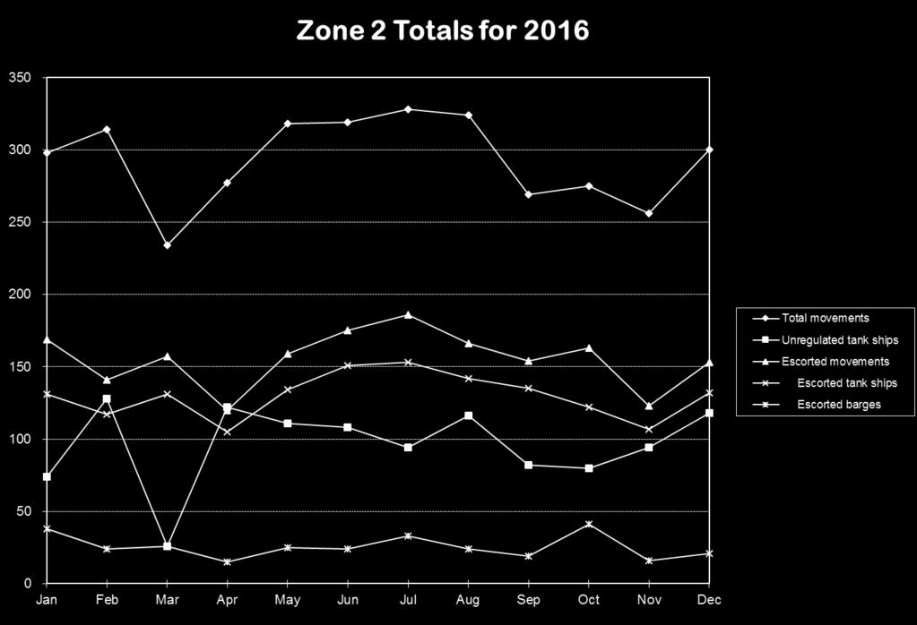
236 Appendix F 227

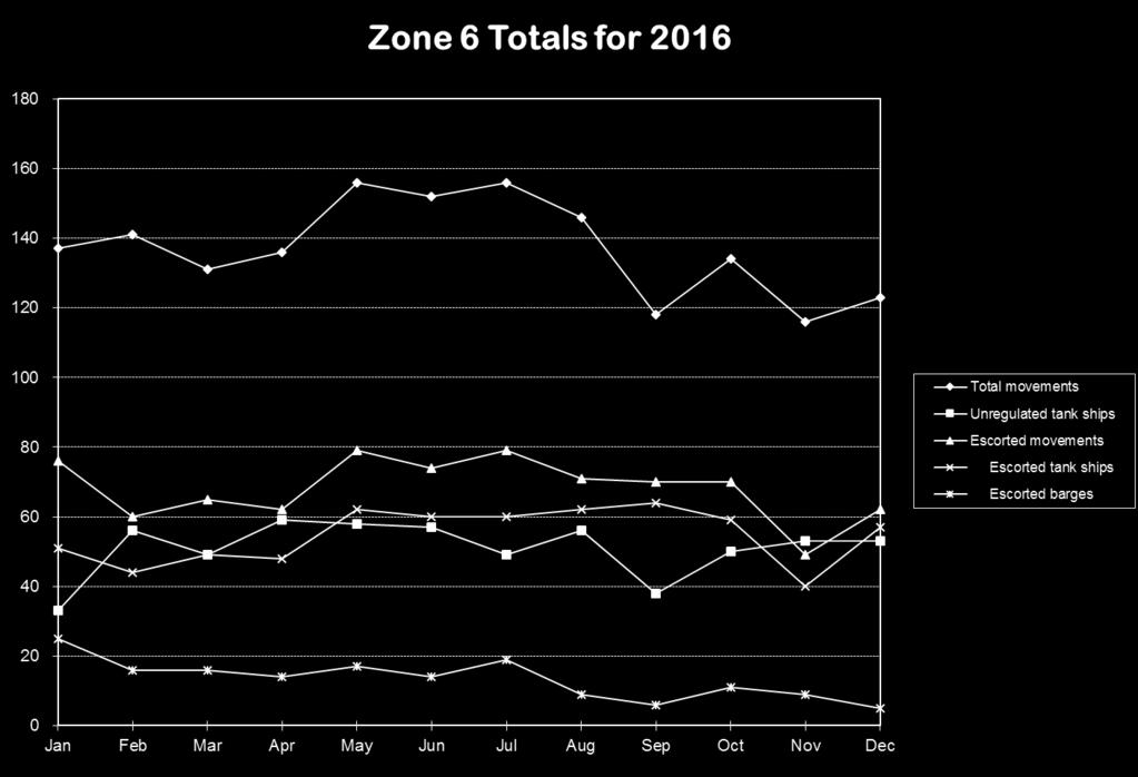
237 Appendix F 228

238 Appendix G Comparative Vessel Movement Totals Total vessel arrivals 3,474 3,236 3,534 Total vessel interbay shifts 2,253 2,478 2,172 Total tanker arrivals 1,079 1,159 1,114 Total tanker interbay shifts 1,501 1,555 1,
239 Appendix G 2016 Tank Vessel Arrivals NAME FLAG Type DWT LOA Arrivals USA ARTICULATED OTB 20, USA ARTICULATED OTB 14, USA ARTICULATED OTB 20, USA ARTICULATED OTB 27, USA ARTICULATED OTB 27, USA ARTICULATED OTB 27, USA ARTICULATED OTB 27, ADAFERA MLT CRUDE OIL TANKER 105, AEGEAN NOBILITY GRC CRUDE OIL TANKER 115, AFRICAN SPIRIT BHS CRUDE OIL TANKER 151, ALASKAN FRONTIER USA CRUDE OIL TANKER 193, ALASKAN NAVIGATOR USA CRUDE OIL TANKER 193, ALBERTA BHS CRUDE OIL TANKER 104, ALEXANDROS II MHL PRODUCT TANKER 51, ALIAKMON LBR PRODUCT TANKER 61, ALLEGRO LBR CHEMICAL/OIL TANKER 46, ALPINE MAYA HKG CHEMICAL/OIL TANKER 51, ALSEA BAY USA TANK BARGE 9, AMAGI GALAXY MHL CHEMICAL/OIL TANKER 26, ANNE ELIZABETH USA TANK BARGE 5, ANTARES USA TANK BARGE 11, ANTIMILOS GRC PRODUCT TANKER 72, AQUALEADER LBR CRUDE OIL TANKER 115, AQUALEGACY LBR CRUDE OIL TANKER 115, AQUALEGEND LBR CRUDE OIL TANKER 115, AQUALIBERTY LBR CRUDE OIL TANKER 115, AQUALOYALTY LBR CRUDE OIL TANKER 115, AQUAMARINE II MHL CHEMICAL/OIL TANKER 50,
240 Appendix G ARCTIC BRIDGE MLT CHEMICAL/OIL TANKER 50, ARDMORE CHEYENNE MHL CHEMICAL/OIL TANKER 25, ARDMORE CHIPPEWA MHL PRODUCT TANKER 25, ARGENT EYEBRIGHT PAN CHEMICAL TANKER 33, ARGENT FREESIA PAN CHEMICAL/OIL TANKER 34, ARGENT IRIS MHL PRODUCT TANKER 34, ARGENT SUNRISE PAN CHEMICAL TANKER 36, ARIES SUN LBR CRUDE OIL TANKER 115, ARIONAS MHL CHEMICAL/OIL TANKER 37, ASOPOS LBR PRODUCT TANKER 61, ATLANTIC FRONTIER HKG CHEMICAL/OIL TANKER 47, ATLANTIC QUEEN HKG PRODUCT TANKER 46, AZALEA GALAXY PAN CHEMICAL TANKER 19, BERENIKE MHL CHEMICAL/OIL TANKER 39, BLUE RIVER LBR PRODUCT TANKER 106, BOX MHL CHEMICAL/OIL TANKER 50, BRITISH CHIVALRY IOM CHEMICAL/OIL TANKER 46, BRITISH MALLARD IOM CRUDE OIL TANKER 11, BW KRONBORG SGP PRODUCT TANKER 73, BW LEOPARD SGP PRODUCT TANKER 49, BW MIA IOM CHEMICAL TANKER 19, BW PUMA SGP PRODUCT TANKER 49, BW STREAM IOM CHEMICAL TANKER 19, BW TIGER SGP PRODUCT TANKER 49, CABO HELLAS MHL PRODUCT TANKER 69, CALIFORNIA VOYAGER USA CHEMICAL/OIL TANKER 45, CALYPSO LBR CHEMICAL/OIL TANKER 46, CAP VICTOR GRC CRUDE OIL TANKER 158, CAPE TALLIN MHL CHEMICAL/OIL TANKER 73, CAPELLA USA TANK BARGE 11, CAPRICORN VOYAGER BHS CRUDE OIL TANKER 104,
241 Appendix G CASCADE SPIRIT BHS CRUDE OIL TANKER 156, CASTOR VOYAGER BHS CRUDE OIL TANKER 104, CELTIC SEA LBR CRUDE OIL TANKER 90, CENTER MLT CRUDE OIL TANKER 156, CHAMPION CORNELIA NOR PRODUCT TANKER 44, CHAMPION EXPRESS LBR CHEMICAL TANKER 43, CHAMPION TERN NIS CHEMICAL/OIL TANKER 47, CHAMPION TIDE NIS CHEMICAL/OIL TANKER 40, CHAMPION TRADER LBR CHEMICAL/OIL TANKER 40, CHAMPION TRUST NOR CHEMICAL/OIL TANKER 39, CHANTAL LBR PRODUCT TANKER 74, CHEMBULK BARCELONA SGP CHEMICAL TANKER 32, CHEMBULK MINNEAPOLIS PAN CHEMICAL/OIL TANKER 33, CHEMBULK VIRGIN GORDA SGP CHEMICAL/OIL TANKER 34, CHEMICAL AQUARIUS HKG CHEMICAL TANKER 18, CHERRY GALAXY PAN CHEMICAL/OIL TANKER 19, CLAXTON BAY HKG CHEMICAL TANKER 36, CLIPPER SKY NIS LIQUID GAS CARRIER 44, COMMANDER LBR CRUDE OIL TANKER 49, COMMENCEMENT BAY USA TANK BARGE 15, CONFIDENCE LBR CRUDE OIL TANKER 71, CYPRESS GALAXY PAN CHEMICAL/OIL TANKER 19, DA YUAN HU CHN CRUDE OIL TANKER 159, DBL 106 USA ARTICULATED OTB 13, DBL 140 USA ARTICULATED OTB 19, DBL 185 USA ARTICULATED OTB 27, DBL 77 USA ARTICULATED OTB 11, DENEB USA TANK BARGE 11, DENSA ORCA MHL NON SPECIFIC TANKER 158, DESPINA GRC PRODUCT TANKER 59, DEVON GRC CRUDE OIL TANKER 157,
242 Appendix G DHT SOPHIE MHL CRUDE OIL TANKER 112, DIAMOND ORCHID SGP CHEMICAL TANKER 19, DONG-A KRIOS PAN PRODUCT TANKER 49, DONG-A TRITON PAN PRODUCT TANKER 49, DORIC BREEZE LBR PRODUCT TANKER 51, DR. ROBERT J. BEALL USA ARTICULATED OTB 14, DRAKES BAY USA TANK BARGE 12, DS PROMOTER LBR CRUDE OIL TANKER 70, DUBAI GLAMOUR MHL CRUDE OIL TANKER 115, EAGLE BAY USA CRUDE OIL TANKER 114, EL JUNIOR PNT MHL PRODUCT TANKER 68, EMMA VICTORY NIS CHEMICAL/OIL TANKER 40, ENERGY CHAMPION IOM PRODUCT TANKER 70, ENERGY CHANCELLOR IOM PRODUCT TANKER 70, ENERGY COMMANDER IOM CRUDE OIL TANKER 70, ENERGY PANTHER IOM CHEMICAL/OIL TANKER 44, ESER K. MHL PRODUCT TANKER 115, ESSIE C MHL PRODUCT TANKER 47, EUROPEAN SPIRIT BHS CRUDE OIL TANKER 151, FANTASIA ITA CHEMICAL/OIL TANKER 51, FIGHT FANCONI ANEMIA USA ARTICULATED OTB 6, FINESSE GRC CRUDE OIL TANKER 150, FLORIDA VOYAGER USA PRODUCT TANKER 46, FORRES PARK HKG CHEMICAL/OIL TANKER 47, FPMC 25 LBR PRODUCT TANKER 50, FRONT ULL MHL CRUDE OIL TANKER 157, FSL HONG KONG SGP CRUDE OIL TANKER 115, FUJI GALAXY MHL CHEMICAL/OIL TANKER 25, GASCHEM BREMEN LBR LIQUID GAS CARRIER 28, GENMAR COMPANION BMU PRODUCT TANKER 72, GENMAR HARRIET G. LBR CRUDE OIL TANKER 150,
243 Appendix G GEORGIS NIKOLOS GRC PRODUCT TANKER 72, GINGA TIGER PAN CHEMICAL TANKER 25, GLADIATOR LBR CRUDE OIL TANKER 149, GODAVARI SPIRIT BHS CRUDE OIL TANKER 159, GOTLAND ALIYA BHS PRODUCT TANKER 53, GOTLAND SOFIA BHS CHEMICAL/OIL TANKER 53, GRAN COUVA HKG CHEMICAL/OIL TANKER 47, GREEN OAK MHL CHEMICAL/OIL TANKER 13, GULF JUMEIRAH BHS CHEMICAL/OIL TANKER 46, GULF RASTAQ BHS CHEMICAL/OIL TANKER 46, GULF STREAM BHS PRODUCT TANKER 74, HAFNIA CRUX DIS CHEMICAL/OIL TANKER 52, HARBOUR FASHION PMD CHEMICAL TANKER 16, HARUNA EXPRESS HKG PRODUCT TANKER 45, HELLESPONT PRIDE MHL PRODUCT TANKER 73, HELLESPONT PROMISE LBR PRODUCT TANKER 73, HELLESPONT PROTECTOR LBR PRODUCT TANKER 73, HERCULES HKG CHEMICAL/OIL TANKER 51, HIGH DISCOVERY MLT CHEMICAL/OIL TANKER 45, HIGH SEAS LBR CHEMICAL/OIL TANKER 51, HUGLI SPRIIT BHS CHEMICAL/OIL TANKER 46, INCA CYP PRODUCT TANKER 68, IPANEMA STREET LBR PRODUCT TANKER 47, IVER EXACT NLD CHEMICAL/OIL TANKER 46, JASMIN JOY BHS CRUDE OIL TANKER 104, KALAMAS LBR CRUDE OIL TANKER 105, KAYS POINT USA TANK BARGE 9, KERALA LBR PRODUCT TANKER 74, KEROS GRC PRODUCT TANKER 74, KIRBY USA ARTICULATED OTB 26, LARVIK BHS PRODUCT TANKER 61,
244 Appendix G LEO USA TANK BARGE 9, LEO SUN LBR CRUDE OIL TANKER 114, LIBERTY BAY USA CRUDE OIL TANKER 114, LIME GALAXY HKG CHEMICAL TANKER 19, LONDON STAR LBR CRUDE OIL TANKER 73, LOVEL BRIERE USA TANK BARGE 8, LUIGI LAGRANGE ITA LIQUID GAS CARRIER 29, LUMEN N PAN PRODUCT TANKER 63, LUZON SPIRIT MHL CRUDE OIL TANKER 109, MAERSK BELFAST SGP CHEMICAL/OIL TANKER 29, MAERSK KIERA SGP CHEMICAL/OIL TANKER 39, MAERSK MARMARA SGP CHEMICAL/OIL TANKER 51, MAERSK MESSINA SGP PRODUCT TANKER 48, MAERSK MIYAJIMA PAN PRODUCT TANKER 12, MAHANADI SPIRIT BHS CHEMICAL/OIL TANKER 44, MARAN PENELOPE GRC CRUDE OIL TANKER 158, MARAN POSEIDON GRC CRUDE OIL TANKER 129, MARE DI GENOVA ITA CHEMICAL/OIL TANKER 51, MARIA PRINCESS LBR CRUDE OIL TANKER 105, MARITINA NIS PRODUCT TANKER 74, MAYA CYP PRODUCT TANKER 68, MEGACORE PHILOMENA MHL PRODUCT TANKER 74, MINDORO STAR MHL PRODUCT TANKER 73, MINERVA SYMPHONY GRC CRUDE OIL TANKER 159, MISS BENEDETTA MLT CHEMICAL/OIL TANKER 50, MISS MARIA ROSARIA MLT CHEMICAL/OIL TANKER 50, MISSISSIPPI VOYAGER USA PRODUCT TANKER 46, MONTEREY BAY USA TANK BARGE 14, MONTESTENA PMD CRUDE OIL TANKER 159, MORRO BAY USA TANK BARGE 14, MOUNT KIBO LBR CHEMICAL/OIL TANKER 37,
245 Appendix G NAVE CETUS LBR PRODUCT TANKER 74, NAVE DORADO PAN PRODUCT TANKER 47, NAVE EQUATOR MLT CHEMICAL/OIL TANKER 50, NAVE LUCIDA PAN PRODUCT TANKER 47, NAVE ORION PAN CHEMICAL/OIL TANKER 49, NAVE UNIVERSE MHL PRODUCT TANKER 45, NAVIG8 AMETHYST MHL CHEMICAL TANKER 37, NAVIG8 AQUAMARINE MHL PRODUCT TANKER 37, NEW BREEZE PAN PRODUCT TANKER 48, NEW CONQUEST MHL PRODUCT TANKER 73, NEW CONSTELLATION MHL PRODUCT TANKER 73, NICOLAOS GRC CRUDE OIL TANKER 164, NINA ITA CHEMICAL/OIL TANKER 40, NINA VICTORY NIS CHEMICAL/OIL TANKER 40, NISSOS KYTHNOS GRC CRUDE OIL TANKER 115, NORD GAINER DNK PRODUCT TANKER 50, NORD GUARDIAN DIS CHEMICAL/OIL TANKER 50, NORD IMAGINATION PAN PRODUCT TANKER 48, NORD OPTIMISER LBR PRODUCT TANKER 47, NORD ORGANISER PAN PRODUCT TANKER 47, NORD SNOW QUEEN DNK CHEMICAL/OIL TANKER 38, NORD STEADY SGP PRODUCT TANKER 49, NORDIC OSLO DNK CHEMICAL/OIL TANKER 12, NORDIC ZENITH LBR CRUDE OIL TANKER 158, NORIENT STAR MLT CHEMICAL/OIL TANKER 40, NS SILVER LBR CHEMICAL/OIL TANKER 47, OLYMPIC SPIRIT USA TANK BARGE 13, OREGON VOYAGER USA CHEMICAL/OIL TANKER 45, ORIENT SUNSHINE PAN PRODUCT TANKER 45, ORIENTAL EMERALD PAN PRODUCT TANKER 50, OVERSEAS ALCMAR MHL CHEMICAL/OIL TANKER 45,
246 Appendix G OVERSEAS ANDROMAR MHL CHEMICAL/OIL TANKER 46, OVERSEAS ARIADMAR MHL CHEMICAL/OIL TANKER 45, OVERSEAS BOSTON USA CHEMICAL/OIL TANKER 46, OVERSEAS GOLDMAR MHL PRODUCT TANKER 69, OVERSEAS KIMOLOS MHL CHEMICAL/OIL TANKER 51, OVERSEAS KYTHNOS MHL CHEMICAL/OIL TANKER 50, OVERSEAS LEYTE MHL PRODUCT TANKER 74, OVERSEAS LOS ANGELES USA PRODUCT TANKER 46, OVERSEAS LUZON MHL PRODUCT TANKER 74, OVERSEAS MARTINEZ USA CHEMICAL/OIL TANKER 46, OVERSEAS NIKISKI USA PRODUCT TANKER 45, OVERSEAS PEARLMAR MHL CRUDE OIL TANKER 69, OVERSEAS ROSEMAR MHL CRUDE OIL TANKER 70, OVERSEAS SAMAR MHL CHEMICAL/OIL TANKER 74, OVERSEAS SILVERMAR MHL PRODUCT TANKER 69, OVERSEAS VISAYAS MHL PRODUCT TANKER 74, PACIFIC BRIDGE MHL CRUDE OIL TANKER 105, PACIFIC DAWN PAN CRUDE OIL TANKER 105, PAMISOS LBR CRUDE OIL TANKER 105, PARAMOUNT HYDRA IOM CRUDE OIL TANKER 113, PECOS MHL CRUDE OIL TANKER 158, PEGASUS VOYAGER BHS CRUDE OIL TANKER 156, PICHINCHA PAN CRUDE OIL TANKER 91, PINE GALAXY BHS CHEMICAL/OIL TANKER 19, PINNACLE SPIRIT BHS CRUDE OIL TANKER 160, POLAR ADVENTURE USA CRUDE OIL TANKER 141, POLAR DISCOVERY USA CRUDE OIL TANKER 141, POLAR ENDEAVOUR USA CRUDE OIL TANKER 141, POLAR ENTERPRISE USA CRUDE OIL TANKER 141, POLAR RESOLUTION USA CRUDE OIL TANKER 140, POLARIS VOYAGER BHS CRUDE OIL TANKER 156,
247 Appendix G POLYAIGOS GRC CRUDE OIL TANKER 69, PRINCIMAR PROMISE MHL CRUDE OIL TANKER 158, PUDU CHL CHEMICAL/OIL TANKER 51, RADIANT SEA MHL CRUDE OIL TANKER 73, RELIANCE II SGP CHEMICAL/OIL TANKER 46, RIDGEBURY JULIA M MHL PRODUCT TANKER 45, RIDGEBURY ROSEMARY E MHL CHEMICAL/OIL TANKER 50, SAKURA EXPRESS HKG PRODUCT TANKER 45, SAMOS BHS CRUDE OIL TANKER 104, SASANOA USA TANK BARGE 7, SCF PEARL LBR PRODUCT TANKER 74, SCF TOMSK LBR LIQUID GAS CARRIER 26, SEA HERMES MLT PRODUCT TANKER 45, SEBAROK SPIRIT BHS CRUDE OIL TANKER 95, SEXTANS HKG CHEMICAL/OIL TANKER 51, SHANGHAI DAWN PAN CRUDE OIL TANKER 111, SHARON SEA LBR PRODUCT TANKER 73, SIERRA USA CRUDE OIL TANKER 124, SILVER CINDY MHL PRODUCT TANKER 52, SILVER EMILY MHL CHEMICAL/OIL TANKER 52, SILVER GINNY MHL PRODUCT TANKER 49, SILVER GWEN PAN PRODUCT TANKER 49, SILVER HAGUE PAN PRODUCT TANKER 49, SILVER HOUSTON PAN PRODUCT TANKER 49, SINGAPORE VOYAGER SGP CRUDE OIL TANKER 105, SITEAM ADVENTURER BMU CHEMICAL/OIL TANKER 46, SITEAM LEADER SGP CHEMICAL/OIL TANKER 46, SIVA ROTTERDAM PAN CHEMICAL TANKER 19, SIXTY FIVE ROSES USA TANK BARGE 13, SKOPELOS GRC PRODUCT TANKER 70, SONANGOL CABINDA BHS CRUDE OIL TANKER 157,
248 Appendix G SONANGOL KALANDULA BHS CRUDE OIL TANKER 157, SONGA BREEZE MHL CHEMICAL TANKER 19, SPRUCE GALAXY SGP CHEMICAL TANKER 19, STAR FALCON PAN PRODUCT TANKER 53, STEALTH II MHL PRODUCT TANKER 50, STELLAR LILAC PAN CHEMICAL TANKER 12, STENA CONQUEROR BMU CHEMICAL TANKER 47, STI AQUA MHL CHEMICAL/OIL TANKER 50, STI BROOKLYN MHL PRODUCT TANKER 50, STI SOHO MHL CHEMICAL/OIL TANKER 50, STI ST CHARLES MHL CHEMICAL/OIL TANKER 50, STI VENERE MHL CHEMICAL/OIL TANKER 49, STI VILLE MHL CHEMICAL/OIL TANKER 49, STI YORKVILLE MHL CHEMICAL/OIL TANKER 49, STRILEN PAN CHEMICAL TANKER 19, STROFADES GRC PRODUCT TANKER 69, SUN PLOEG CYM CHEMICAL TANKER 19, SUNSET BAY USA TANK BARGE 11, SUSANNE VICTORY NIS CHEMICAL/OIL TANKER 48, TAVRICHESKY BRIDGE LBR PRODUCT TANKER 46, THEO T. BHS CRUDE OIL TANKER 73, TORM ALEXANDRA SGP CHEMICAL/OIL TANKER 49, TORM AMALIE SGP CHEMICAL/OIL TANKER 49, TORM CECILIE DIS CHEMICAL/OIL TANKER 44, TORM GERD MHL CHEMICAL/OIL TANKER 46, TORM GERTRUD MHL CHEMICAL/OIL TANKER 46, TOURAINE HKG LIQUID GAS CARRIER 30, UNITED BANNER GRC PRODUCT TANKER 73, UNITED CARRIER GRC PRODUCT TANKER 73, VALLE BIANCA ITA CHEMICAL/OIL TANKER 50, VALROSSA ITA CHEMICAL/OIL TANKER 50,
249 Appendix G VELEBIT HRV CHEMICAL/OIL TANKER 52, VINJERAC HRV CHEMICAL/OIL TANKER 51, YASA GOLDEN BOSPHORUS MHL CRUDE OIL TANKER 115, YASA GOLDEN HORN MHL CRUDE OIL TANKER 116, ZAO GALAXY MHL CHEMICAL/OIL TANKER 26, ZARUMA PAN CRUDE OIL TANKER 105, ZEFYROS PAN CHEMICAL/OIL TANKER 50,
250 Appendix H Recommendations for conducting Escort Training on San Francisco Bay 1.0 OVERVIEW At the inception of Escort Regulations tractor tugs were just beginning to be introduced in San Francisco Bay. Many of the maneuvers that a tractor tug could perform to help reduce speed or steer a tanker were innovative. As tractor tugs have become the dominant escorting tug these maneuvers have become common practice among all escorts and now are incorporated during normal assists performed on tankers and non-tank vessels. For example arresting maneuvers to reduce speeds are practiced on many container ships entering the port of Oakland. The training that in the past would require a full-blown drill is now accomplished during everyday operations. In addition to on the water training, companies are making extensive use of simulators to address training in their Safety Management Systems. Often this training will incorporate all other industry segments so that there are pilots, vessel operators, and tug crew in the simulator training together. Most facilities have dual simulators so that a tug operator can be in one simulator working with the pilot and the vessel crew in the other simulator. Industry has made use of these facilities to simulate tug/vessel interactions in common navigational areas and also made use of them to simulate interactions at terminals only in the design stage. Training will continue to play a critical role in safe transits through San Francisco Bay. 2.0 PURPOSE To outline and define the process by which pilots, escort tug and ship crews can arrange for and participate in live escort training exercises. This process will enable training to be conducted under agreed upon conditions to promote the safety of all involved. This training process will allow opportunities for demonstration, practice and skill enhancement for emergency response maneuvers. Lessons learned and best practices developed during these training sessions should be shared between the participants. 3.0 SCOPE These voluntary recommendations are for the use of all pilots and tug crews actively offering their services as escorts in the Bay. By extension, the users of the services, the escorted vessel crews will also be included in the scope of these recommendations. 241
251 Appendix H 4.0 RESPONSIBILITIES AND AUTHORITIES The pilot, tug captain and ship master have the responsibility to evaluate prior to each training session if it is appropriate to conduct training under the current environmental conditions, which maneuvers are to be demonstrated, where the training will be conducted and at what speed. If all three parties cannot agree, the training will not proceed. 5.0 SCHEDULING EXERCISES It is intended that these training exercises may be conducted when weather conditions and / or vessel scheduling allows. It is expected that the pilot will initiate the request to conduct these exercises, however the shipmaster or escort tug captain may initiate them. Each may decline to participate with no negative consequences should he or she feel that it is inappropriate. Tug escort captains and / or mates qualified to conduct escort operations are to be preauthorized by their companies to make the decision on board if requested by the pilot. Prior to agreeing to conduct the training, the participants should consider weather, sea conditions, the degree of training of the participants, the speed of the escorted vessel and the maneuvers to be executed. Only when all parties agree that it is appropriate will the training proceed. Each party may also halt the training exercise if he or she becomes concerned for any reason. 6.0 TRAINING EXERCISES When a training exercise is agreed to, the pilot and tug operator should carefully discuss the maneuvers that they want to demonstrate. The tug operator should be the one to specify at what speeds he will be comfortable performing the maneuvers in question based on his personal experience level and training. 7.0 ESCORT LANGUAGE In order to work towards a stronger bridge team, this training will encourage all participants to use a standardized tug command language. 8.0 CROSS DECK TRAINING The San Francisco Bar Pilots, the Chevron Pilots and the independent pilots of the Bay recognize the benefit of understanding how the tug crews operate their vessels during an escort. Towards that end the pilots will be encouraged to ride on board a tug during an escort. 242
252 Appendix H 9.0 TRIALS / TRAINING INFORMATION The participants recognize that less than perfect performance may occur as part of this training process. Further, as new employees are brought on board this learning-by-doing process will continue into the future. The participants shall not use the outcome of other organization s exercises as part of their own commercial activities. It will be acceptable to discuss one s own organization s training activities as part of your advertising if desired. These guidelines anticipated live escort training exercises; however, few opportunities arise for on-water exercises involving tankers and tugs, with few individuals trained for emergency events. With maritime simulators becoming more sophisticated in their ability to replicate a variety of situations and with a California Maritime Academy simulator operational, the HSC found simulating local conditions to be a cost-effective alternative to on-water exercises. The Tugs Work Group concluded that in addition to promoting simulator training for tugs escorting tankers, simulator training is applicable to tugs assisting and docking container ships, bulk carriers and chemical ships thus providing industry-wide benefits for safe navigation. The HSC recommends the use of simulators to improve communication between pilots and tug masters, offer in-house training to tug industry personnel, and provide valuable lessons learned for emergency situations in a controlled environment. 243

253 Appendix I Sites of San Francisco Bay PORTS Stations (Physical Oceanographic Real Time System) 244
254 Appendix J San Francisco Bay Area Bridges: Characteristics and Construction Projects Significant bridge projects presently underway in the San Francisco Bay Area: The replacement of the east section of the San Francisco-Oakland Bay Bridge between YBI and Oakland is completed. The estimated completion date for the entire project, including removal of the replaced bridge, is The reasonable needs of navigation are being met during the work. Updates continue via Local Notices to Mariners and Broadcast Notices to Mariners. Caltrans is proposing to replace the Hwy 12 Drawbridge across the Sacramento River at Rio Vista with a mid level drawbridge or high level fixed bridge. They are considering 4 alignment alternatives. With the assistance of the SF/Sacramento Corps of Engineers, SF Bar Pilots, ship rides & chart reviews, he Coast Guard has provided navigational clearance requirements for each alignment to ensure the proposed replacement bridge will meet the existing and future navigational needs for the largest vessels on the waterway. San Mateo Transit District is continuing their proposal to replace the drawspan of the Dumbarton railroad drawbridge and resume usage of the bridge for commuter and freight rail traffic, sometime after The Eleventh Coast Guard District is coordinating with the bridge owner and other agencies to ensure the proposed work will not have negative impacts on the reasonable needs of waterway traffic, during or after the proposed work. A Coast Guard Bridge Permit, pursuant to the General Bridge Act of 1946, will be required for the work, and is subject to the provisions of the National Environmental Policy Act. The Golden Gate Bridge District is planning to replace the existing maintenance traveler system on the GG Bridge. They are also planning to install a suicide prevention net system on the bridge. Neither activity by the bridge owner is expected to change the navigational clearance provided by the bridge. 245
255 Appendix J San Francisco Bay Area Bridges: Characteristics and Construction Projects Significant bridge projects presently underway in the San Francisco Bay Area: The replacement of the east section of the San Francisco-Oakland Bay Bridge between YBI and Oakland is completed. The estimated completion date for the entire project, including removal of the replaced bridge, is The reasonable needs of navigation are being met during the work. Updates continue via Local Notices to Mariners and Broadcast Notices to Mariners. Caltrans is proposing to replace the Hwy 12 Drawbridge across the Sacramento River at Rio Vista with a mid level drawbridge or high level fixed bridge. They are considering 4 alignment alternatives. With the assistance of the SF/Sacramento Corps of Engineers, SF Bar Pilots, ship rides & chart reviews, he Coast Guard has provided navigational clearance requirements for each alignment to ensure the proposed replacement bridge will meet the existing and future navigational needs for the largest vessels on the waterway. The Golden Gate Bridge District is planning to replace the existing maintenance traveler system on the GG Bridge. They are also planning to install a suicide prevention net system on the bridge. Neither activity by the bridge owner is expected to change the navigational clearance provided by the bridge. 246
256 Appendix J San Francisco Bay Area Bridges Encountered By Ocean Going Vessels (For up to date clearance information refer to the latest NOAA chart or the USCG Bridge Section) CLEARANCES BRIDGE NAME AND LOCATION TYPE Horz/Vert MLLW-MHW 1. Golden Gate Bridge SUS 4028/ San Francisco Bay 2. San Francisco-Oakland SUS San Francisco Bay, Westerly Reach Span A-B, Pier A 2229/ Pier B 229/ Span B-C, Pier B 1072/ Pier C 1072/ Span C-D, Pier C 1079/ Pier D 1079/ Span D-E, Pier D 2210/ Pier E 2210/ Span E-YB Isl, Pier E Fixed 870/ Richmond-San Rafael Fixed San Francisco Bay Main Channel, Center Span 1000/ Left and Right Span 480/ East Channel, Center Span 970/ Carquinez Fixed Carquinez Strait, Vallejo Upstream Bridge: South (left) Span, South Pier 998/ South (left) Span, North Pier 998/ North (right) Span, South Pier 1000/ North (right) Span, North Pier 1000/ Downstream Bridge: South (left) Span, South Pier 1030/ South (left) Span, North Pier 1030/ North (right) Span, South Pier 1030/ North (right) Span, North Pier 1030/ Martinez, Highway Bridge Fixed Martinez/Benicia 440/ Martinez, Union Pacific RR Bridge V/L Martinez/Benicia, Raised 291/ Lowered 291/ Antioch Fixed Antioch, CA San Joaquin River 400/
257 Appendix J San Francisco Bay Area Bridges Encountered By Ocean Going Vessels (For up to date clearance information refer to the latest NOAA chart or the USCG Bridge Section) CLEARANCES BRIDGE NAME AND LOCATION TYPE Horz/Vert MLLW-MHW 8. Golden Gate Bridge SUS 4028/ San Francisco Bay 9. San Francisco-Oakland SUS San Francisco Bay, Westerly Reach Span A-B, Pier A 2229/ Pier B 229/ Span B-C, Pier B 1072/ Pier C 1072/ Span C-D, Pier C 1079/ Pier D 1079/ Span D-E, Pier D 2210/ Pier E 2210/ Span E-YB Isl, Pier E Fixed 870/ Richmond-San Rafael Fixed San Francisco Bay Main Channel, Center Span 1000/ Left and Right Span 480/ East Channel, Center Span 970/ Carquinez Fixed Carquinez Strait, Vallejo Upstream Bridge: South (left) Span, South Pier 998/ South (left) Span, North Pier 998/ North (right) Span, South Pier 1000/ North (right) Span, North Pier 1000/ Downstream Bridge: South (left) Span, South Pier 1030/ South (left) Span, North Pier 1030/ North (right) Span, South Pier 1030/ North (right) Span, North Pier 1030/ Martinez, Highway Bridge Fixed Martinez/Benicia 440/ Martinez, Union Pacific RR Bridge V/L Martinez/Benicia, Raised 291/ Lowered 291/
258 Appendix K Sector San Francisco - Port Safety Statistics: 2016 Total Reported Marine Casualties By Type/Month for Chart 1 Jan Feb Mar Apr May Jun Jul Aug Sep Oct Nov Dec Total Avg per month Allision Collision Fire Capsize Grounding Sinking Steering Propulsion Personnel Other Power Total Total Letters of Deviation (LODs) Issues Due to Navigational Deficiencies/Month for Chart 2 Jan Feb Mar Apr May Jun Jul Aug Sep Oct Nov Dec Total Avg per month Radar Gyro Compass Steering Echo Depth Sounder AIS ARPA Speed Log Other Total
259 Appendix K Total Port State Control Detentions/Month for Chart 3 Jan Feb Mar Apr May Jun Jul Aug Sep Oct Nov Dec Total Avg per month SOLAS STCW MARPOL ISM ISPS Total Total COTP Orders/Month for Chart 4 Jan Feb Mar Apr May Jun Jul Aug Sep Oct Nov Dec Total Avg per month Navigation Safety Port Safety & Security ANOA Total Total Reported Marine Casualties By Type/Year Chart Total Avg Allision Collision Fire Capsize Grounding Sinking Steering Propulsion Personnel Other Power Reported Rule 9 Violations/Month for 2016 Jan Feb Mar Apr May Jun Jul Aug Sep Oct Nov Dec Total Avg per month Reported Navigation Rule 9 Violations

260 Appendix K 251
261 Appendix K 252
262 Appendix K 253
263 Appendix K 254
264 Appendix K 255
265 Appendix K DISTRICT 11 LOSS OF PROPULSION INCIDENTS ON DEEP DRAFT Monthly Totals in Loss of Loss of Total Loss Safety Jan Feb Mar Apr May Jun Jul Aug Sep Oct Nov Dec Jan Feb Mar Apr May Jun Jul Aug Sep Oct Nov Dec Jan Feb Mar Apr May Jun Jul Aug Sep Oct Nov Dec Jan Feb Mar
266 Appendix K Apr May Jun Jul Aug Sep Oct Nov Dec Jan Feb Mar Apr May Jun Jul Aug Sep Oct Nov Dec Jan Feb Mar Apr May Jun Jul Aug Sep Oct Nov Dec Jan Feb Mar Apr May Jun Jul Aug Sep
267 Appendix K Oct Nov Dec Jan Feb Mar Apr May Jun Jul Aug Sep Oct Nov Dec Jan Feb Mar Totals

268 Appendix K 259
269 Appendix L Sector San Francisco Pollution Statistics: 2016 Total Reported Oil Pollution Incidents/Yr - Chart Total Avg Total Number of Oil Pollution Incidents Total Reported Oil Spills by Source/Yr - Chart Total Avg U.S. Commercial Vessels Foreign Freight Vessels** Public Vessel Commercial Fishing Vessel Recreational Vessel Regulated Waterfront Facilities Regulated Waterfront Facilities-Fuel Transfer** Other Land Source* Unknown Source Total Reported Oil Pollution Incidents and Amounts/Month for Chart 3 Jan Feb Mar Apr May Jun Jul Aug Sep Oct Nov Dec Total Avg Total Number of Oil Pollution Incidents Total Amount of Oil Discharged and/or Hazardous Material Released (gallons) Total Reported Amount of Oil and/or Hazardous Material Released by Vessels/Month for Chart 4 Jan Feb Mar Apr May Jun Jul Aug Sep Oct Nov Dec Total Avg Total Amount of Oil and/or Hazardous Material Released (gallons)
270 Appendix L Total Reported Oil/Hazmat Pollution Incidents/Month for Chart 6 Jan Feb Mar Apr May Jun Jul Aug Sep Oct Nov Dec Total Avg # of Spills between 0 -'10 gallons # of Spills between 10 -'100 gallons # of Spills between 100 -'1,000 gallons # of Spills 1,000 gallons > # of Spills -'Unknown size Total Oil Discharge and/or Hazardous Material Release Volumes By Source (gallons)/month for Chart 7 Jan Feb Mar Apr May Jun Jul Aug Sep Oct Nov Dec Total Avg U.S. Commercial Vessels Foreign Freight Vessels Public Vessels Commercial Fishing Vessels Recreational Vessels Regulated Waterfront Facilities Regulated Waterfront Facilities-Fuel Transfer Other Land Sources Unknown Source unk unk unk unk unk 0 unk unk unk unk unk unk Total Pollution related Penalty Actions/ Month for 2016 Jan Feb Mar Apr May Jun Jul Aug Sep Oct Nov Dec Total Avg Civil Penalty Cases for Period Notice of Violations (TKs) Letter of Warning (LOW)

271 Appendix L 262

272 Appendix L 263
273 Appendix L 264
274 Appendix L 265
275 Appendix L 266

276 Appendix L 267
277 Appendix L 268
278 Appendix M CALIFORNIA STATE LANDS COMMISSION SAN FRANCISCO REGION Waterborne Petroleum Cargo Statistics January 1, 2016 December 31, 2016 Product Load Discharge Additives - Alkylate 848,600 2,131,648 Additives-Denatured Ethanol 632,000 0 Additives - Ethanol 357,500 0 Additives - Isomerate 893, ,000 Additives - Naphtha 2,053, ,500 Additives - Other 222, ,300 Additives Reformate 1,730,000 0 Additives Toulene 0 85,400 Aviation Gasoline 327,000 26,400 Bio-Diesel 0 324,900 Crude ANS 100,000 26,592,900 Crude- Bakken 0 338,000 Crude Import 150, ,807,452 Crude Other 495, ,000 Cutter Stock 153,635 94,100 Decant 25, ,400 Diesel 23,957,892 4,907,320 Fuel Oil 16,694,835 6,190,480 Gas-Oil 246,000 0 Gasoline 24,897,900 14,329,572 Jet Fuel 3,680,400 6,568,000 Light Cycle Oil 5,066,000 30,569,300 Lube Oil 3,070,900 60,000 MDO 0 0 Other 73, ,313 Polymer ,197 0 Renewable Diesel 0 135,000 Tetramer 302,000 0 Transmix 93, ,400 Total 86,084, ,801,385 Grand total # of barrels: 309,885,

279 Appendix N Senate Bill 414; Complete Text Harbor Safety Committee of the San Francisco Bay Region Assessment of Offshore Emergency Towing Capabilities In the San Francisco Area of Responsibility Pursuant to California Senate Bill 414 April
280 Appendix N Senate Bill 414; Complete Text Table of Contents Introduction II. Scope of Assessment Geographic Area of Responsibility Arrest Drift or otherwise Guide Emergency Transit III. Data Collection and Analysis West Coast Risk Management Assessment of United States Coast Guard s Port State Control and Marine Inspection Programs United States Coast Guard Incident Data San Francisco Bay Tug Inventory and Capability IV. Harbor Safety Committee of the San Francisco Bay Region: Best Maritime Practice - Emergency Offshore Towing V. Measures to prevent a disabled vessel from drifting ashore VI. Summary of Findings and Conclusion Appendices (A - G) A. Senate Bill Complete Text B. Harbor Safety Committee of the San Francisco Bay Region Senate Bill 414 Workgroup Membership C. Office of Spill Prevention and Response Administrator s Letter to Harbor Safety Committee of the San Francisco Bay Region D. Historic Casualty Data Collected ( ) E. United States Coast Guard Marine Inspection/Port State Control Program Data and Report F. Harbor Safety Committee of the San Francisco Bay Region: Best Maritime Practice-Emergency Offshore Towing G. Bibliography 271
281 Appendix N Senate Bill 414; Complete Text I. Introduction California Senate Bill 414 (SB 414) was signed into law by Governor Edmund G. Brown, Jr., and became effective January 1, Among other requirements, the bill directs the Administrator of the Office of Spill Prevention and Response (OSPR) to task the Harbor Safety Committee of the San Francisco Bay Region (SF HSC): to assess the presence and capability of tugs within their respective geographic area of responsibility to provide emergency towing of tank and nontank vessels to arrest their drift or otherwise guide emergency transit. The assessment must consider data from United States Coast Guard (USCG) Vessel Traffic Service (VTS), relevant incident and accident data and simulation models, transit areas where risks might be elevated, and the condition of tank and non-tank vessels calling San Francisco Bay ports, including data from the USCG s marine inspection program and port state control program. 1 A letter from OSPR Administrator Thomas M. Cullen dated January 25, 2016 provided further guidance for this assessment. 2 The SF HSC Tug Workgroup (Workgroup) met for the first time in April 2016 to review the tasking of SB 414 and to begin discussion and information gathering. 3 The Workgroup identified the following core issues: Identify the geographic area of responsibility (AOR) for the assessment Determine the meaning of arrest the drift or otherwise guide emergency transit Gather relevant VTS incident data Compile information regarding the present inventory of available towing equipment Identify any limitations for available equipment Determine run-time requirements to deliver assistance within the AOR Analyze information from the USCG s Port State Control Program and Marine Inspection Program to assess the condition of the tank and non-tank vessels calling on the San Francisco Bay ports 1 See, Appendix A for the complete text of Senate Bill See, Appendix C 3 See, Appendix B for the list of SF HSC Workgroup members. 272
282 Appendix N Senate Bill 414; Complete Text Identify lessons learned from local tug company actual emergency towing experiences Review the San Francisco Ultra Large Container Vessel towing exercise Identify any transit areas of concern Assess the relevance of the extensive work the SF HSC compiled to create their Best Maritime Practice-Emergency Offshore Towing standard of care 4 Coordinate with the Los Angeles/Long Beach and other California Harbor Safety Committees The Workgroup membership is composed of a cross section of maritime professionals with expertise in a number of disciplines including vessel operations and offshore towing. Pertinent to this assessment, they evaluated numerous factors and conditions that could affect a disabled vessel and a response tug such as: historical responses, type and size of vessels that typically call in the San Francisco Bay Region, the number and dispersion and bollard pull of tugs of opportunity in the harbor and offshore waters, the availability of emergency towing equipment, the expected run-time of a response tug, the areas where response times are more critical, and deck configurations on disabled vessels taken under tow. The primary focus of this study is to assess response tug capability. At the outset, the Workgroup acknowledged that many varied factors affect this analysis. Severe weather in the offshore waters can increase overall risk by increasing a disabled vessel s drift rate, decreasing a response tug s speed (thus increasing its run-time), and hampering a response crew s ability to connect towing equipment to a disabled vessel. Conversely, there are oftentimes opportunities to reduce risk by controlling or influencing the drift of a disabled vessel in a manner that affords additional time for response assets to arrive on scene. Ships crews can use bow thrusters or partially functioning engines to reduce their vessel s drift rate or alter its drift direction, and, should the vessel drift nearer to shore (and into more shallow waters), in all likelihood deploy the disabled ship s anchor(s) and arrest its drift before it goes aground. When assessing hypothetical failure scenarios absolute conclusions are not likely. Nonetheless, a qualitative analysis of the likelihood and potential consequence related to a hypothetical occurrence can be achieved. Toward that end, clearly defining the scope for this study will focus our analysis and facilitate more reliable conclusions. 4 See, Appendix F. 273
283 Appendix N Senate Bill 414; Complete Text II. Scope of Assessment The San Francisco Harbor Safety Committee was tasked with assessing the presence and capability of tugs within its geographic area of responsibility. In assessing the capability of tugs to respond to a disabled vessel in the offshore waters of the San Francisco Bay Region, the Workgroup followed guidance from the OSPR Administrator and limited its study to vessels 300 gross tons and larger. This category includes vessels of the following types: Oil Tankers, Chemical Tankers, Container Ships, Passenger Ships, Vehicle Carriers, General Cargo/Multi- Purpose Ships, Bulk Carriers, Barges and Articulated Tug/Barge Units, Ro-Ro Cargo Ships, Refrigerated Cargo Carriers, and Heavy Lift Ships. Geographic Area of Responsibility The policies and recommendations of the San Francisco Harbor Safety Committee typically address vessel safety in the offshore waters only out to the western boundary of the San Francisco, San Pablo and Suisun Bays Harbor Safety Plan, which is described by a circle with a radius of six nautical miles (nm) centered on San Francisco Approach Lighted Horn Buoy SF ( N, W) and including the San Francisco Main Ship Channel. 5 Nevertheless, this study requires an assessment of activities farther offshore related to vessels arriving and departing from San Francisco Bay ports, thus requiring a broader scope. The San Francisco Vessel Traffic Service (VTS) area of responsibility extends farther seaward and is bounded by an arc with a 38-mile radius from Mt. Tamalpais in Marin County ( 'N 'W). For the purpose of this study, the Workgroup adopted that same geographic Area of Responsibility (AOR), which includes the Traffic Separation Scheme traffic lanes and precautionary area. 6 See graphic on page 5, below. 5 See, the San Francisco, San Pablo and Suisun Bays Harbor Safety Plan, June 9, 2016; Page 1. 6 SF HSC makes no claim to areas outside SF HSC AOR s as defined in the San Francisco, San Pablo and Suisun Bays Harbor Safety Plan. The VTS AOR was adopted for this study solely to meet the intent of the author of SB

284 Appendix N Senate Bill 414; Complete Text Geographic limit of the San Francisco SB 414 Study Arrest Drift or otherwise Guide Emergency Transit The SF HSC interprets arrest their drift or otherwise guide emergency transit of a vessel as the ability of response tugs to: take the disabled vessel under tow, stabilize the disabled vessel and maintain its position, or slow the drift rate or influence the drift direction of the disabled vessel until additional response tugs or other assistance can reach the scene. 275
285 Appendix N Senate Bill 414; Complete Text The ultimate objective of arrest drift or otherwise guide emergency transit is to prevent a vessel from grounding. This analysis does not apply beyond the point where sufficient towing assets have arrived on scene to stabilize the emergency situation. Additional resources may be needed to safely direct the vessel to a harbor of safe refuge 7 or safe anchorage, which is beyond the scope of this study. III. Data Collection and Analysis The Workgroup and its partners collected data from many sources including the USCG, OSPR, National Oceanic and Atmospheric Administration, and a representative cross section of industry representatives. The Workgroup also researched previous studies as sources of data relevant to this study. The following information was gathered and reviewed: West Coast Offshore Vessel Traffic Risk Management Project, Final Report, 2002 Historical data from USCG Port State Control and Marine Inspection Programs USCG District 11 incident data from 2010 to 2016 Inventory of San Francisco tugboats, including their equipment and capabilities The SF HSC s Best Maritime Practice-Emergency Offshore Towing standard of care The SF HSC Best Maritime Practice-Emergency Offshore Towing (BMP) was developed in with USCG Sector San Francisco. The BMP memorializes procedures for planning and execution of an emergency tow. It is designed to protect resources by ensuring that appropriate actions are taken to prevent a drift grounding in the coastal areas near San Francisco Bay. 8 7 Harbor of Safe Refuge means a port, inlet, or other body of water normally sheltered from heavy seas by land and in which a vessel can navigate and safely moor. The suitability of a location as a harbor of safe refuge shall be determined by the cognizant Officer in Charge, Marine Inspection, and varies for each vessel, dependent on the vessel's size, maneuverability, and mooring gear. See, 46 CFR See, Section IV, infra, for further discussion. See also, Appendix F for the full text of the BMP. 276
286 Appendix N Senate Bill 414; Complete Text West Coast Risk Management The West Coast Offshore Vessel Traffic Risk Management (WCOVTRM) Project studied grounding risk and made recommendations to reduce the risk of collisions or drift groundings caused by vessels transiting 3 to 200 nautical miles off the U.S. West Coast between Cook Inlet to the north and San Diego to the south. The project evaluated vessels 300 gross tons and larger, including tankers, cargo and passenger vessels, fishing vessels and tank barges. The study was co-sponsored by the Pacific States/British Columbia Oil Spill Task Force and the USCG, Pacific Area. Although the 2002 study was broader than this assessment, it contains relevant findings and information. From 1999 to 2002, the WCOVTRM project collected and reviewed data on a number of risk factors and modeled likely tug response times under both average and severe weather conditions. To develop risk management recommendations, the WCOVTRM project ranked factors that contributed to higher risk scores by region. The WCOVTRM project was able to prioritize risk factors by recognizing that some could be mitigated. Based on their analysis the following four risk factors were found most amenable to improvement through technology advancement or policy implementations: 9 distance offshore: risk of grounding decreases with greater distance from shore; traffic density leading to collision hazard; tug availability: risk of grounding decreases with rescue vessel availability and capability; and historical casualty: risk increases for vessel types with relatively higher historical casualty rates. Key findings of the 2002 West Coast Offshore Vessel Traffic Risk Management Project include the following: 1. The WCOVTRM project group found that it would be beneficial to enhance tug position and capability information coast-wide. Since the study report was published, U.S. domestic requirements for AIS carriage have been established. The AIS system allows anyone to view the location of tugs as well as other vessels along the West Coast in real time. It also reduces the collision risks associated with traffic density by allowing timely exchange of important vessel information. 9 West coast offshore vessel traffic risk management project (Final Report, 2002), Pacific States/British Columbia Oil Spill Task Force and the U.S. Coast Guard, Pacific Area; p. 1. Retrieved from, Report.pdf. 277
287 Appendix N Senate Bill 414; Complete Text 1. The WCOVTRM project group found that the risk of a grounding/collision generally increases the closer a vessel transits to shore. The WCOVTRM project group recommended all vessels greater than 300 GRT should maintain a minimum distance of 25 miles from the coast and tank vessels should maintain a minimum distance of 50 miles from the coast. Voluntary compliance with these recommendations has been demonstrated above 90%. The recommendation has also been included in United States Coast Pilots and Canadian Sailing Directions. This tends to route vessels farther offshore, which in general increases drift distance for any vessel becoming disabled and affords more time for response vessels to arrive on scene. 2. The WCOVTRM project group found better casualty reporting data was needed. Since the study report was published, the USCG has compiled monthly casualty reports that include all loss of propulsion (LOP) incidents. These reports are routinely presented at meetings of the SF HSC. Moreover, implementation of the 2012 North American Emission Control Area clean fuel requirements has incentivized vessels-in-transit to remain 200 miles offshore, which, as discussed above, reduces the grounding risks associated with disabled vessels. Based upon the actions taken by maritime industry stakeholders since the release of the WCOVTRM project findings and recommendations, the SF HSC finds that the risk of offshore incidents including the likelihood of a vessel grounding, has been significantly reduced. 278
288 Appendix N Senate Bill 414; Complete Text Assessment of United States Coast Guard s Port State Control and Marine Inspection Programs United States Coast Guard s Port State Control Program (Foreign Flag Vessels) SB 414 requires the review of the USCG s Port State Control (PSC) and Marine Inspection Programs regarding risks due to a vessel s hull or engineering material deficiencies, or inadequate crew training and professionalism. The Los Angeles/Long Beach Harbor Safety Committee and the Harbor Safety Committee of the San Francisco Bay Region employed an innovative and streamlined approach to assess the condition of the United States Coast Guard s PSC program. (See Appendix E for study.) The HSCs recognized a worldwide network of PSC regimes exist with the goal to eliminate substandard shipping. The USCG holds observer status within both the Memorandum of Understanding on Port State Control in the Asia-Pacific Region (Tokyo MoU) and Paris Memorandum of Understanding on Port State Control (Paris MoU). Similarly, the Tokyo MoU and the Paris MoU has each granted observer status to the other. The Paris MoU, Tokyo MOU and the USCG each produce an annual PSC report, which list the Vessel Detention Rate due to unsatisfactory Safety Examination results. The USCG s annual reports also list the Detention Rate for California known as District 11 s Detention Rate. The HSCs reviewed six years ( ) of data published in annual reports from the Paris and Tokyo MoUs and USCG. This assessment encompassed PSC data from forty-five countries on five continents, 651,134 PSC vessel boardings, 350,943 Safety Examinations and 12,991 Detentions. Utilizing the Detention Rate derived from PSC data, the HSCs were able to quantify the quality of vessels calling California ports by comparing the California Vessel Detention Rate (CVDR) weighted average against the combined PSC authorities detention rate weighted average. Using the CVDR in this way enables a relative assessment of the condition, or quality, of vessels calling California ports. As reflected in the table below, the CVDR weighted average at % is the lowest of all surveyed PSC organizations. It indicates vessels calling California are 99.84% less likely to possess the characteristics that would warrant a PSC detention than in other parts of the world. The HSCs find the general condition of foreign vessels calling California ports and the condition of the USCG s Port State Control program to be adequate. 279
289 Appendix N Senate Bill 414; Complete Text PSC Authority No. of Safety Examinations No. of Detentions Detention Rate % Weighting % Based on Detentions* Detention Rate Weighted Average** (Detention Rate % x Weight) (A) (B) (C) (D) (E) (F) (C) / (B) (D) X (E) Tokyo MoU 178,148 8, % 62.70% % Paris MoU 115,399 4, % 30.96% % USCG less D 11 50, % 5.77% % D11 (CVDR) 6, % 0.58% % Totals 350,943 12, % % PSC Detention Rate Weighted Average (W.A) % CVDR W.A % CVDR W.A. Below PSC Detention Rate W.A % Percent CVDR W.A. is below PSC Detention Rate W.A %*** Notes: Table reflects all detentions; not limited to propulsion, steering and electrical incidents * Calculation is Number of Detentions by a PSC divided by the sum of all PSC Detentions (12,991) ** Calculation is Detention Rate % multiplied by the Weighting % *** Calculation is % less % divided by % United States Coast Guard s Marine Inspection Program (U.S. Flag Vessels) Published each year in the Paris MoU and Tokyo MoU Annual Reports, is an updated document entitled, White, Grey and Black (WGB) List. The WGB List represents the full spectrum, from quality flag states to flag states with a poor performance that are considered high risk. It is based on the total number of inspections and detentions and is the results from PSC inspections. 10 The WGB List reflects the quality of a flag state s (marine) inspection program as well as the quality of vessels and vessel operators. The White List contains a list of flag states found to be of higher quality and lower risk. Conversely, the Black List contains a list of flag states found to be substandard and of higher risk. 11 The Gray List is a list of flag states that may be simply described as average, average being considered less than ideal. Independent third party audits, more commonly referred to as PSC inspections, over the last six consecutive years have reflected favorably upon the flag state of United States as well as the condition of the USCG s Marine Inspection Program. During the sample period ( ), the flag state of United States attained White List, low risk status 83% of the time. Moreover, over the past four 10 "White, Grey and Black List." Paris MoU. Paris MoU, Web. 27 December "White, Grey and Black List." Paris MoU. Paris MoU, Web. 27 December
290 Appendix N Senate Bill 414; Complete Text consecutive years ( ), the flag state United States attained White List, low risk status 100% of the time. Accordingly, the HSCs find the condition of United States vessels 300 GRT and greater and the condition of the USCG s Marine Inspection Program to be adequate. United States Coast Guard Incident Data The USCG District 11 provided the SF HSC with reportable incident data occurring over a seven-year period (from 2010 to 2016). The data include reports of propulsion losses as well as other types of incidents such as problems with navigation, electrical, or steering systems. The USCG requires a vessel to report any occurrence when critical systems fail, even if the failure is only of brief duration and the problem is resolved quickly. Moreover, reportable incident data include cases where there is a limitation rather than a complete failure. For example, engines operating at less than full power, engines capable of propelling a vessel forward but not in reverse, or two-engine ships that lose power from one of the engines are all reportable incidents. Because the threshold for a reportable incident is quite low, many reported incidents do not rise to the level of posing a drift grounding risk, which is the focus of this study. For the most part, reported incidents are typically corrected before the vessel enters San Francisco Bay. Of the incidents that cannot be immediately corrected, most do not completely disable the vessel. Despite this, the USCG Captain of the Port will normally place restrictions on the vessel until repairs can be completed and such an order will often include a requirement for tugs to escort the vessel into port as a precautionary measure. These incidents must be distinguished from those rare incidents wherein a vessel becomes completely disabled and requires a tow into port. The following table summarizes total incidents and the number of ships requiring a tow from January 1, 2010-December 31,
291 Appendix N Senate Bill 414; Complete Text SECTOR SAN FRANCISCO SUMMARY OF INCIDENTS AND SHIPS NEEDING A TOW Incidents reported to Coast Guard District 11, Alameda, CA YEAR TOTAL INCIDENTS (NOTE 1) PROPULSION STEERING ELECTRICAL TOTAL SHIPS NEEDING TOW (NOTE 2) TANKERS CONTAINER AND BULK SHIPS TOTAL SHIP TRANSITS (NOTE 3) TOTAL LOP INCIDENT RATE (NOTE 4) % % % % % % % TOTAL % 0.004% % vessels needing tow (NOTE 5) NOTE 1: NOTE 2: NOTE 3: NOTE 4: NOTE 5: Incidents that occurred on deep draft ocean-going vessels over 300 gross tons OUTSIDE COLREGS DEMARCATION LINE. An "Incident" is defined to be something related to propulsion, steering, or other similar casualty that did or could result in a drifting ship needing tug assistance. Total ships needing a tow that were OUTSIDE COLREGS DEMARCATION LINE. The ships needing to be towed were both inbound arrivals and outbound departures. Therefore, the total ship count column is the sum of arrivals and departures. Incident rate is the total number of incidents divided by the total ship transits. Percentage represents that 1 ship in 854 transits had an incident. Percentage represents that 1 ship in 26,144 transits needed a tow. The overall total of incidents (propulsion, steering, or other similar casualty that did or could result in a drifting ship needing tug assistance) as reported by vessels 300 GRT or larger in the SF AOR was 69. Of these, the data reveal that there were 59 LOP casualties. Cases involving fishing and pleasure boats, search and rescue cases, medical evacuations, rules of the road and VTS procedures violations are not included in this data. Of the 69 incidents reported, only two vessels required emergency tows. During the same period there were 52,986 transits in the study area. As shown in the table above, the two incidents requiring a tow comprised 0.004% of the total ship transits through the Golden Gate during the reporting period. Based on the incident rate, the SF HSC finds the risk of vessel failure requiring a tow within the offshore study area to be extremely low. 282
292 Appendix N Senate Bill 414; Complete Text San Francisco Bay Tug Inventory and Capability The tug inventory shown in the table below was provided by the local tug companies in October and November This data quantifies the tugs assigned to the San Francisco Bay Region at that time. It is important to note that this inventory is a snapshot in time," and homeport assignments for tugs can change. Nonetheless, it provides a current summary distribution of tugs with ocean going towing capabilities within the region. Tug Bollard Pull (Tons) 12 Range (days) Tow Winch (on Stern) Wire on drum Arrest Tow Availability DELTA BILLIE Crewed DELTA CATHRYN Crewed VALOR Crewed VETERAN Crewed AHBRAFRANCO Crewed ROBERT FRANCO Crewed PACIFIC STAR 87 7 Crewed AMERICA 85 7 Crewed LYNN MARIE 75 7 Callout KEEGAN FOSS Callout PATRICIA ANN 70 4 Crewed SANDRA HUGH 68 4 Crewed REVOLUTION 66 4 Crewed LIBERTY Crewed Z-FIVE 50 8 Crewed Z-FOUR 50 8 Crewed Z-THREE 50 8 Crewed SCORPIUS Callout POINT FERMIN Crewed POINT VICENTE Callout PATRIOT 33 Crewed ORION Callout SAGITTARIAN Callout ROYAL MELBOURNE Crewed TAURUS Callout BEARCAT 9 14 Callout Current Tug Inventory in The San Francisco Bay Region 12 Bollard pull is a measure of a tug s maximum pulling power measured in tons. 283
293 Appendix N Senate Bill 414; Complete Text The Workgroup compared the current inventory to an older inventory contained in the 2002 WCOVTRM project report 13 that compiled similar data. The comparison shows that the current tug inventory in San Francisco Bay is more robust today; larger and more capable tugs are currently available. Per the 2002 WCOVTRM project, tugs with 40 tons of bollard pull or more meet the criteria for a rescue from the Golden Gate south, and for the area north of the Gate, 60 tons or more. At the time of the project, ten tugs operating in the San Francisco Harbor had bollard pull capability of 40 tons or greater of which seven tugs had bollard pull capability of at least 60 tons. The most powerful two tugs both had a bollard pull capability of 71 tons. In 2016, the number of tugs operating in the harbor with a bollard pull capability of 40 tons or greater has increased by seventy percent to seventeen tugs, of which thirteen tugs have a bollard pull capability of 60 tons or more. Moreover, two tugs have bollard pull capabilities in the mid 80s (85 tons and 87 tons) and in the most dramatic difference from the 2002 WCOVTRM project to 2016, six tugs have a bollard pull of 90 tons or more. All of the tug companies with tugs capable of pulling more than 40 tons have emergency offshore towing packages available. In summary, today there is a larger and more powerful cadre of tugs ready and available to respond to offshore emergencies. Based on the investigation by the Workgroup, the majority of the relevant San Francisco Bay tugs are crewed twenty-four hours a day and the remaining have crews readily available on short notice. While the tugs are primarily dedicated to work within the San Francisco Bay, they can be dispatched for rescue work at any time. Local stakeholders understand the importance of rendering aid to a vessel in distress, and local tug operators are prepared to give emergency response the highest priority. While rarely necessitated, the regional stakeholders, specifically tug operators, have demonstrated their ability to respond quickly during the few cases when offshore emergencies have arisen. Additionally, continual improvement and towing capability readiness is maintained through regular exercises. 14 Some of these exercises are described in more detail on page West coast offshore vessel traffic risk management project (Final Report, 2002), Pacific States/British Columbia Oil Spill Task Force and the U.S. Coast Guard, Pacific Area; p.34. Retrieved from, Report.pdf. 14 See, requirements contained in the Bay Region Best Maritime Practice-Emergency Offshore Towing, a standard of care developed by the SF HSC. 284
294 Appendix N Senate Bill 414; Complete Text The SF HSC finds there is a high likelihood that tugs will be readily available and equipped to respond to a disabled vessel in the San Francisco AOR. IV. Harbor Safety Committee of the San Francisco Bay Region: Best Maritime Practice- Emergency Offshore Towing Recognizing the need to advance best offshore emergency towing practices for the San Francisco Bay Region, beginning in January 2013 the SF HSC Tug Workgroup worked with USCG Sector San Francisco to develop the Best Maritime Practice-Offshore Emergency Towing (BMP), a standard of care that has been included in the SF Harbor Safety Plan. 15 The SF HSC adopted the BMP in April The document guides the deployment of the best towing assets with the most appropriate equipment and properly trained crews during an emergency. The Typical Decision/Action Matrix for Emergency Offshore Towing, shown below on page 17, depicts the risk-based priority for dispatching tugs to emergencies in the offshore waters outside of the Golden Gate. The matrix is a tool designed to assist the Coast Guard, vessel operators and towing companies to identify higher risk areas and to inform vessel operators of USCG expectations and potential actions that might be required depending on the disabled vessel s distance from shore. The matrix does not definitively dictate the boundaries between the areas of high, medium and low risk; rather it is a tool to enhance risk assessment and decision-making. The BMP chart that follows the matrix, shown below on page 16, shows the drift distances to shore and the run-time of tug boats traveling at 10 knots (11.4 m.p.h.), which is a relatively conservative response speed that was assumed for planning purposes. At the time the diagram was constructed, the Tug Workgroup concluded the drift rate toward shore would not exceed 2 knots in most circumstances. The dark red zone triggers USCG Captain of the Port jurisdiction where, regardless of drift, the Coast Guard will likely take action given the close proximity to shore. The light red zone represents the nearest risk to that zone, with the yellow and green zones being areas where there is more time for planning. Additional factors such as prevailing weather, vessel traffic conditions, actual drift rate, and vessel material condition also impact risk assessment and associated response posture. The goal of any response should be preventing a vessel from grounding. That being said, a vessel becoming disabled in 15 See, Appendix F for full text of the Best Maritime Practice-Offshore Emergency Towing. 285
295 Appendix N Senate Bill 414; Complete Text or near the highest risk (red) areas without adequate tugs on station to stabilize and control the situation requires the most rapid response. But when an incident occurs farther offshore, the risk of drifting into danger near shore is reduced and may afford additional time to prepare a response and tow plan. As previously stated, the BMP standard of care is predicated upon a two-knot drift rate, which should provide a good basis for analysis in most circumstances. However, actual worst case scenario drift rates could be greater, and are discussed in more detail below. Under normal circumstances, the Coast Guard will direct that response tugs adequate to control the situation be in place before a disabled vessel drifts within 12 nautical miles from shore. The matrix is designed to prompt action to assist this outcome. The BMP also includes IMO guidelines on emergency towing procedures, including preparation of an Emergency Towing Booklet in accordance with SOLAS Ch. II-1, Reg. 3-4, a sample of which is contained in the BMP. A communications checklist, ship rescue requirement checklist and example tow configurations also are provided. 286

296 Appendix N Senate Bill 414; Complete Text 287

297 Appendix N Senate Bill 414; Complete Text 288
298 Appendix N Senate Bill 414; Complete Text On-water Exercise. In May 2014, the Tug Workgroup tested provisions of the BMP when it joined with tug operators and the Navigation Workgroup in Central San Francisco Bay to conduct an on-water emergency tow of an Ultra Large Container Vessel. With a goal of testing command and control emergency towing operations, the scenario involved the 1,190-foot, 128,550 deadweight tonnage (DWT) Containership CMA CGM CENTAURUS operating without power. Three different tow companies participated in the exercise and successfully demonstrated the ability of a single tug to tow a vessel experiencing a LOP as well as a tandem tow utilizing two tugs. The San Francisco Bar Pilots stationed a pilot on board the ship to monitor the drill. The tugs towing capabilities were tested with one tug able to tow the ship at 4.3 kts and two tugs together at 6 kts. Synthetic towlines were used during the drill whereas longer towing chains would normally be used in offshore conditions. Lessons learned include the importance of having a tug at the stern of the ship to assist with steering, the importance of direct communication between the tugs, the importance of familiarity with the Emergency Towing Booklet, and the importance of effective command and control. Included in development and implementation of the Best Maritime Practice-Offshore Emergency Towing, described above, local maritime stakeholders conducted a tabletop exercise for a simulated incident and After Action Review (AAR) for both simulated and actual incidents to assess readiness to provide emergency towing of a disabled vessel in the offshore AOR. The process tests and evaluates response asset availability and response time based on real-time vessel traffic and tug inventory. After Action Review. In July 2016, the Tug Workgroup and the SF VTS conducted an AAR to debrief stakeholders of an actual offshore incident involving the 590-foot, 37,429 DWT bulk carrier, MV ULTRA LASCAR. On May 20, 2016, MV ULTRA LASCAR experienced a loss of propulsion while transiting in the Northern Traffic Lane en route to Stockton, California. The vessel was unable to restart her engine and subsequently, drifted toward the coast. When the vessel reached a position approximately 5 miles from shore off Daly City, California, per US Coast Guard direction, it safely deployed its anchor to arrest its drift. Shortly thereafter, response assets arrived on scene including a San Francisco Bar Pilot (who boarded the vessel) and three emergency response tugs as well as equipment to tow the vessel to port. The USCG, the towing company and the vessel agent participated in the AAR as well as other governmental agencies and key maritime stakeholders. Lessons learned included, the following: 289
299 Appendix N Senate Bill 414; Complete Text Thorough communication between all parties was a key factor contributing to the successful outcome of this incident, The communication/notification process was identified as an area in need of improvement. The incident also highlighted and reconfirmed that deploying the ship s anchor(s) is a key mitigation measure available to a vessel to reduce, or even eliminate, the risk of drift grounding in the offshore marine environment. V. Measures to prevent a disabled vessel from drifting ashore A cursory inspection of the Tug Workgroup Offshore Geographic Priority Regions graphic on page 18 reveals that there are areas within the SF AOR where a vessel could lose power and drift toward shore at a rate that might not afford sufficient response time meaning the ship could run ashore. For example, if a ship were to lose power in the Northbound Traffic Lane due southwest of Point Reyes, it would be set adrift within about 4 miles of the shore at Point Reyes. If strong southwesterly winds caused the disabled vessel to drift at 2 knots 16 in a northeasterly direction, it would drift ashore in two hours. But the response time (according to the matrix) is three hours. Therefore, there may not be sufficient time for response assets to reach the drifting vessel in this particular hypothetical scenario. Indeed, many more hypothetical scenarios could be imagined wherein there might not be sufficient response time to prevent a drift grounding. This is particularly true when one considers worst case drift rates. The 2002 WCOVTRM project group found the following drift rates applied in the waters off San Francisco: The drift speed during average onshore wind conditions is 1.3 knots. The drift speed during worst case onshore wind conditions is 3.3 knots The Tug Workgroup Offshore Geographic Priority Regions graphic contained in the BMP assumes a two-knot drift rate. 17 West coast offshore vessel traffic risk management project (Final Report, 2002), Pacific States/British Columbia Oil Spill Task Force and the U.S. Coast Guard, Pacific Area; Appendix F. Retrieved from, Report.pdf. 290
300 Appendix N Senate Bill 414; Complete Text As discussed above, the planning tools in the SF HSC Best Maritime Practice-Offshore Emergency Towing assume a 2-knot drift rate. This drift rate should be consistent with the actual drift of a disabled vessel in most circumstances and it forms a perfectly valid preliminary assumption for analysis of actual emergency events. However, SB 414 requires the current assessment to consider worst case drift scenarios, and the 2002 WCOVTRM findings are instructional. Using the project s higher worst case drift rate (3.3 knots), the time available for response tugs to arrive on scene is further diminished, which elevates the grounding risk. However, there are mitigation measures available to reduce, or even eliminate that increased grounding risk. In those circumstances wherein a disabled vessel is drifting into shallow water before response tugs arrive on scene, it can deploy its anchors to arrest its drift. Emergency anchoring under these circumstances alleviates the exigency by stopping the vessel drift and affording additional time for the response tugs to arrive on scene, as demonstrated by the recent ULTRA LASCAR incident. It should be noted that anchoring a drifting vessel close inshore is not in and of itself a solution to the emergency. A disabled vessel anchored on a lee shore remains exposed to elevated risk. Nevertheless, there is an extremely high likelihood that this mitigation measure will arrest the vessel s drift until response assets arrive. Yet, a disabled vessel does not necessarily need to wait until it drifts into shallow water to deploy its anchors to arrest its drift. Deep water anchoring is a proven methodology that has long been used to arrest a disabled vessel s drift. For example, in October of 1978, off the coast of California, a 35,000 deadweight ton coastwise tanker used this approach when it became disabled just north of Point Reyes and began drifting toward shore. According to the vessel master, the ship was southbound off Point Reyes when it lost propulsion. The ship initially drifted northeasterly with the current and then easterly with the wind. There was a 50-fathom (300-foot) spot two to three miles off the beach. The crew lowered the port anchor under power as the ship neared the 50-fathom curve. 18 When the anchor started to bump on the bottom, they paid out the anchor slowly until it stopped the vessel s drift. With the anchor down, the ship awaited assistance in a stabilized condition. Subsequently, a response tug from nearby San Francisco Bay arrived on the scene and towed the ship to port Ships are fitted with emergency diesel generators to provide power to anchoring equipment independent of a ship s propulsion system. 19 Recollections of Captain John C. Porter during interview, March
301 Appendix N Senate Bill 414; Complete Text As discussed above, the planning tools in the SF HSC Best Maritime Practice-Offshore Emergency Towing assume a 2-knot drift rate. This drift rate should be consistent with the actual drift of a disabled vessel in most circumstances and it forms a perfectly valid preliminary assumption for analysis of actual emergency events. However, SB 414 requires the current assessment to consider worst case drift scenarios, and the 2002 WCOVTRM findings are instructional. Using the project s higher worst case drift rate (3.3 knots), the time available for response tugs to arrive on scene is further diminished, which elevates the grounding risk. However, there are mitigation measures available to reduce, or even eliminate that increased grounding risk. In those circumstances wherein a disabled vessel is drifting into shallow water before response tugs arrive on scene, it can deploy its anchors to arrest its drift. Emergency anchoring under these circumstances alleviates the exigency by stopping the vessel drift and affording additional time for the response tugs to arrive on scene, as demonstrated by the recent ULTRA LASCAR incident. It should be noted that anchoring a drifting vessel close inshore is not in and of itself a solution to the emergency. A disabled vessel anchored on a lee shore remains exposed to elevated risk. Nevertheless, there is an extremely high likelihood that this mitigation measure will arrest the vessel s drift until response assets arrive. Yet, a disabled vessel does not necessarily need to wait until it drifts into shallow water to deploy its anchors to arrest its drift. Deep water anchoring is a proven methodology that has long been used to arrest a disabled vessel s drift. For example, in October of 1978, off the coast of California, a 35,000 deadweight ton coastwise tanker used this approach when it became disabled just north of Point Reyes and began drifting toward shore. According to the vessel master, the ship was southbound off Point Reyes when it lost propulsion. The ship initially drifted northeasterly with the current and then easterly with the wind. There was a 50-fathom (300-foot) spot two to three miles off the beach. The crew lowered the port anchor under power as the ship neared the 50-fathom curve. 20 When the anchor started to bump on the bottom, they paid out the anchor slowly until it stopped the vessel s drift. With the anchor down, the ship awaited assistance in a stabilized condition. Subsequently, a response tug from nearby San Francisco Bay arrived on the scene and towed the ship to port Ships are fitted with emergency diesel generators to provide power to anchoring equipment independent of a ship s propulsion system. 21 Recollections of Captain John C. Porter during interview, March
302 Appendix N Senate Bill 414; Complete Text To the southwest of the Farallon Islands, the 45 Fathom curve is approximately 2 miles offshore from the islands and rocks. Although less than ideal, two miles should be enough distance offshore for most disabled vessels to get their anchor(s) down, pay out enough chain, and stop their drift prior to standing into danger. Of course this assumes timely and appropriate action on the part of the ship s crew. Even though the bottom in this area is comprised primarily of rock (which is not ideal holding ground) most vessels should be able to safely anchor during large swells and strong winds using one or two anchors, provided they deploy a sufficient scope (length) of anchor chain. Nevertheless, this area poses moderate concern, because the 45 Fathom curve lies only 2 miles from shore. Approximately 2 miles to 45 fathom Approximately 2 miles to 45 fathom Farallon Islands 293
303 Appendix N Senate Bill 414; Complete Text To the southwest of Noonday Rock, the 45 Fathom curve is slightly less than 1 mile offshore from the islands and rocks. A one-mile safety margin between the water depth where any ship should be able to deploy its anchor(s) and the grounding line 22 may not be sufficient in all circumstances, particularly if strong winds and large swells are present. Because of deep water in close proximity to the southwest of Noonday Rock, the Workgroup identified this as an area of concern. Some vessels in some weather conditions could have difficulty deploying anchors prior to grounding. However, this limited area only poses a danger during weather from the Southwest quadrant (which could cause a vessel to drift toward the southwest side of Noonday Rock). Coupled with the fact that this isolated area is located far from the Traffic Separation Scheme, and very few vessels over 300 gross tons transit through these waters, the likelihood of a drift grounding event occurring in this location is extremely low. Noonday Rock Less than 1 mile to 45 fathom curve 22 The grounding line is the point separating those waters where a ship will float from the waters where it will not. It is the point where a ship s hull comes into contact with the seabed. 294
304 Appendix N Senate Bill 414; Complete Text The SF HSC finds that the area southwest of Noonday Rock is an area of concern. The Workgroup s concern would only attach to vessels transiting to the southwest of the Farallon Islands and becoming disabled, then drifting to the northeast toward Noonday Rock. It should be noted that the area is of very limited extent and vessels over 300 gross tons rarely if ever travel this route. The likelihood of an occurrence in this area is extremely low. VI. Summary of Findings and Conclusion The San Francisco Harbor Safety Committee recognizes a multitude of causes can result in a vessel losing propulsion and/or maneuverability and that each case is different; however, based on historical incidents and new information gathered in support of this study, the SF HSC has determined there is a sufficient presence and capability of tugs within the San Francisco Bay to provide emergency towing of tank and non-tank vessels to arrest their drift or otherwise guide emergency transit within the San Francisco VTS area. The large availability of response tugs in the San Francisco Bay Region allows emergency towing services to be dispatched any time day or night. The quality of the vessels and crews calling at San Francisco Bay Region ports is generally very high as indicated by reliable data from the annual reports of the USCG s Port State Control Program, the Tokyo MoU, and the Paris MoU. Historically, there have been few vessel failures that necessitated a tow. The VTS Traffic lanes route traffic in a manner that reduces grounding risk. Whenever vessels have experienced failures in the SF AOR, they have typically had sufficient sea room to drift until propulsion was restored or tug boats arrived on scene to provide assistance. The AOR is characterized with ample opportunity to anchor due to relatively shallow waters extending well out from shore. Only one limited area of concern (to the southwest of Noonday Rock) has been identified where deeper water extends closer to shore. However, the associated grounding risk is very low due to the limited extent of the area, few vessels transit the area, and the likelihood that events would act in concert to cause a drift grounding in this area is low. Nevertheless, the SF HSC recommends the following measure to mitigate this very low-level risk: 295
305 Appendix N Senate Bill 414; Complete Text The SF HSC recommends that steps be taken to raise awareness of the limited anchoring opportunity and the grounding risks associated with vessels over 300 gross tons transiting through our AOR on the offshore side of the Farallon Islands during southwesterly weather. Lastly, it is essential that any disabled vessel make relevant reports promptly to the USCG, communicate with its owners/agents and the towing company, and activate its Vessel Response Plan as required. Early notification and preparation for towing can aide a successful outcome. Conclusion: The Harbor Safety Committee of the San Francisco Bay Region finds that there is a very high degree of likelihood that the resources presently in place in the San Francisco Bay Region are, and will continue to be, sufficient to arrest the drift of a disabled vessel or otherwise influence its drift to prevent it from grounding in the San Francisco Area of Responsibility. 296
306 Appendix N Senate Bill 414; Complete Text Senate Bill No. 414 CHAPTER 609 An act to amend Sections , , , and of, and to add Sections , , and to, the Government Code, relating to oil spill response. [ Approved by Governor October 08, Filed with Secretary of State October 08, ] LEGISLATIVE COUNSEL'S DIGEST SB 414, Jackson. Oil spill response. (1) The Lempert-Keene-Seastrand Oil Spill Prevention and Response Act generally requires the administrator for oil spill response, acting at the direction of the Governor, to implement activities relating to oil spill response, including emergency drills and preparedness, and oil spill containment and cleanup. The act authorizes the administrator to use volunteer workers in response, containment, restoration, wildlife rehabilitation, and cleanup efforts for oil spills in waters of the state. Existing law requires the administrator to evaluate the feasibility of using commercial fishermen and other mariners for oil spill containment and cleanup. This bill would require the administrator, in cooperation with the United States Coast Guard, to establish a schedule of drills and exercises that are required under the federal Salvage and Marine Firefighting regulations. The bill would require the administrator, on or before January 1, 2017, to submit to the Legislature a report assessing the best achievable technology of equipment for oil spill prevention, preparedness, and response and to update regulations governing the adequacy of oil spill contingency plans before July 1, The bill would require the administrator to direct the Harbor Safety Committees for various regions to assess, among other things, the presence and capability of tugs within their respective regions of responsibility to provide emergency towing of tank and nontank vessels to arrest their drift or guide emergency transit. (2) The act requires the administrator to study the use and effects of methods used to respond to oil spills and to periodically update the study to ensure the best achievable protection from the use of those methods. This bill would require the administrator, in conducting the study and updates, to consult current peer-reviewed published scientific literature. The bill would require the administrator, by May 1, 2016, to request that the federal California Dispersant Plan be updated, as provided, and to provide support and assistance in that regard. (3) The act requires the administrator to license oil spill cleanup agents for use in response to oil spills. This bill would require the administrator, if dispersants are used in response to an oil spill, to submit to the Legislature a written notification of, and a written justification for, the use of dispersants and a report on the effectiveness of the dispersants used, as provided. 297
307 Appendix N Senate Bill 414; Complete Text (4) Existing law establishes the Oil Spill Technical Advisory Committee and requires the committee to provide recommendations to, among other entities, the administrator on the implementation of the act. This bill would require the committee to convene a taskforce to evaluate the feasibility of using vessels of opportunity for oil spill response. The bill would require the taskforce to provide recommendations to the administrator and the Legislature on whether vessels of opportunity should be included in oil spill response planning. (5) The act makes a person who causes or permits a spill or inland spill strictly liable for specified penalties for the spill on a per-gallon-released basis. The act provides that the amount of penalty is reduced by the amount of released oil that is recovered and properly disposed of. This bill would eliminate that reduction in the penalty by the amount of oil recovered and properly disposed of. DIGEST KEY Vote: majority Appropriation: no Fiscal Committee: yes Local Program: no BILL TEXT THE PEOPLE OF THE STATE OF CALIFORNIA DO ENACT AS FOLLOWS: SECTION 1. Section is added to the Government Code, to read: In addition to Section , the administrator, in cooperation with the United States Coast Guard, shall establish a schedule of drills and exercises required pursuant to Section of Title 33 of the Code of Federal Regulations. The administrator shall make publicly available the established schedule. SEC. 2. Section of the Government Code is amended to read: (a) The administrator shall conduct studies and evaluations necessary for improving oil spill response, containment, and cleanup and oil spill wildlife rehabilitation in waters of the state and oil transportation systems. The administrator may expend moneys from the Oil Spill Prevention and Administration Fund created pursuant to Section , enter into consultation agreements, and acquire necessary equipment and services for the purpose of carrying out these studies and evaluations. (b) The administrator shall, consulting current peer-reviewed published scientific literature, study the use and effects of dispersants, incineration, bioremediation, and any other methods used to respond to a spill and, by May 1, 2016, request that the federal California Dispersant Plan be updated pursuant to subdivision (d). The study shall periodically be updated by the administrator, consulting current peer-reviewed published scientific literature, to ensure the best achievable protection from the use of those methods. Based upon substantial evidence in the record, the 298
308 Appendix N Senate Bill 414; Complete Text administrator may determine in individual cases that best achievable protection is provided by establishing requirements that provide the greatest degree of protection achievable without imposing costs that significantly outweigh the incremental protection that would otherwise be provided. The studies shall do all of the following: (1) Evaluate the effectiveness of dispersants and other chemical, bioremediation, and biological agents in oil spill response under varying environmental conditions. (2) Evaluate potential adverse impacts on the environment and public health including, but not limited to, adverse toxic impacts on water quality, fisheries, and wildlife with consideration to bioaccumulation and synergistic impacts, and the potential for human exposure, including skin contact and consumption of contaminated seafood. (3) Recommend appropriate uses and limitations on the use of dispersants and other chemical, bioremediation, and biological agents to ensure they are used only in situations where the administrator determines they are effective and safe. (c) The studies shall be performed with consideration of current peer-reviewed published scientific literature and any studies performed by federal, state, and international entities. The administrator may enter into contracts for the studies. (d) The administrator shall support the federal Regional Response Team, as described in Section of Title 40 of the Code of Federal Regulations, in the development, and shall request regular updates, of plans and procedures for use of dispersants and other chemical agents in California. The administrator s assistance may include, but is not limited to, providing the federal Regional Response Team with current peer-reviewed published scientific literature, and risk and consequence analysis. SEC. 3. Section of the Government Code is amended to read: (a) The administrator shall periodically evaluate the feasibility of requiring new technologies to aid prevention, response, containment, cleanup, and wildlife rehabilitation. (b) (1) On or before January 1, 2017, the administrator shall submit a report to the Legislature, pursuant to Section 9795, assessing the best achievable technology of equipment for oil spill prevention, preparedness, and response. (2) The report shall evaluate studies of estimated recovery system potential as a methodology for rating equipment in comparison to effective daily recovery capacity. (3) Pursuant to Section , this subdivision is inoperative on July 1, (c) (1) Including, but not limited to, the report prepared pursuant to subdivision (b), the administrator shall update regulations governing the adequacy of oil spill contingency plans for best achievable technologies for oil spill prevention and response no later than July 1, (2) The updated regulations shall enhance the capabilities for prevention, response, containment, cleanup, and wildlife rehabilitation. (d) (1) The administrator shall direct the Harbor Safety Committees, established pursuant to Section , to assess the presence and capability of tugs within their respective geographic 299
309 Appendix N Senate Bill 414; Complete Text areas of responsibility to provide emergency towing of tank vessels and nontank vessels to arrest their drift or otherwise guide emergency transit. (2) The assessments for harbors in the San Francisco Bay area and in Los Angeles-Long Beach area shall be initiated by May 1, The assessments for the other harbors shall be initiated by January 1, (3) The assessment shall consider, but not be limited to, data from available United States Coast Guard Vessel Traffic Systems, relevant incident and accident data, any relevant simulation models, and identification of any transit areas where risks are higher. (4) The assessment shall consider the condition of tank and nontank vessels calling on harbors, including the United States Coast Guard s marine inspection program and port state control program regarding risks due to a vessel s hull or engineering material deficiencies, or inadequate crew training and professionalism. SEC. 4. Section is added to the Government Code, to read: If dispersants are used in response to an oil spill in state waters, the administrator shall provide written notification of their use to the Legislature within three days of the use. The administrator shall provide the Legislature with written justification of their use, including copies of key supporting documentation used by the federal on-scene coordinator and the federal Regional Response Team as soon as those material are released. Within two months of the use of dispersants in state waters, the administrator shall also provide a report to the Legislature on the effectiveness of the dispersants used, including, but not limited to, results of any available monitoring data to determine whether the dispersant use resulted in overall environmental benefit or harm. The written notification, justification, and report shall be submitted pursuant to Section SEC. 5. Section of the Government Code is amended to read: (a) The administrator, taking into consideration the facility or vessel contingency plan requirements of the State Lands Commission, the Office of the State Fire Marshal, the California Coastal Commission, and other state and federal agencies, shall adopt and implement regulations governing the adequacy of oil spill contingency plans to be prepared and implemented under this article. All regulations shall be developed in consultation with the Oil Spill Technical Advisory Committee, and shall be consistent with the California oil spill contingency plan and not in conflict with the National Contingency Plan. The regulations shall provide for the best achievable protection of waters and natural resources of the state. The regulations shall permit the development, application, and use of an oil spill contingency plan for similar vessels, pipelines, terminals, and facilities within a single company or organization, and across companies and organizations. The regulations shall, at a minimum, ensure all of the following: (1) All areas of state waters are at all times protected by prevention, response, containment, and cleanup equipment and operations. 300
310 Appendix N Senate Bill 414; Complete Text (2) Standards set for response, containment, and cleanup equipment and operations are maintained and regularly improved to protect the resources of the state. (3) All appropriate personnel employed by operators required to have a contingency plan receive training in oil spill response and cleanup equipment usage and operations. (4) Each oil spill contingency plan provides for appropriate financial or contractual arrangements for all necessary equipment and services for the response, containment, and cleanup of a reasonable worst case oil spill scenario for each area the plan addresses. (5) Each oil spill contingency plan demonstrates that all protection measures are being taken to reduce the possibility of an oil spill occurring as a result of the operation of the facility or vessel. The protection measures shall include, but not be limited to, response to disabled vessels and an identification of those measures taken to comply with requirements of Division 7.8 (commencing with Section 8750) of the Public Resources Code. (6) Each oil spill contingency plan identifies the types of equipment that can be used, the location of the equipment, and the time taken to deliver the equipment. (7) Each facility, as determined by the administrator, conducts a hazard and operability study to identify the hazards associated with the operation of the facility, including the use of the facility by vessels, due to operating error, equipment failure, and external events. For the hazards identified in the hazard and operability studies, the facility shall conduct an offsite consequence analysis that, for the most likely hazards, assumes pessimistic water and air dispersion and other adverse environmental conditions. (8) Each oil spill contingency plan contains a list of contacts to call in the event of a drill, threatened discharge of oil, or discharge of oil. (9) Each oil spill contingency plan identifies the measures to be taken to protect the recreational and environmentally sensitive areas that would be threatened by a reasonable worst case oil spill scenario. (10) Standards for determining a reasonable worst case oil spill. However, for a nontank vessel, the reasonable worst case is a spill of the total volume of the largest fuel tank on the nontank vessel. (11) Each oil spill contingency plan specifies an agent for service of process. The agent shall be located in this state. (b) The regulations and guidelines adopted pursuant to this section shall also include provisions to provide public review and comment on submitted oil spill contingency plans. (c) The regulations adopted pursuant to this section shall specifically address the types of equipment that will be necessary, the maximum time that will be allowed for deployment, the maximum distance to cooperating response entities, the amounts of dispersant, and the maximum time required for application, should the use of dispersants be approved. Upon a determination by the administrator that booming is appropriate at the site and necessary to provide best achievable protection, the regulations shall require that vessels engaged in lightering operations be boomed prior to the commencement of operations. (d) The administrator shall adopt regulations and guidelines for oil spill contingency plans with regard to mobile transfer units, small marine fueling facilities, and vessels carrying oil as 301
311 Appendix N Senate Bill 414; Complete Text secondary cargo that acknowledge the reduced risk of damage from oil spills from those units, facilities, and vessels while maintaining the best achievable protection for the public health and safety and the environment. SEC. 6. Section is added to the Government Code, to read: (a) The committee shall convene a taskforce, including appropriate state and federal governmental representatives, nongovernmental organizations, oil spill response organizations, and commercial fishing and other potential vessels of opportunity, to evaluate and make recommendations regarding the feasibility of using vessels of opportunity for oil spill response in marine waters. The evaluation shall examine the following: (1) Appropriate functions of vessels of opportunity during an oil spill. (2) Appropriate management of a vessel s of opportunity spill response program. (3) Vessels of opportunity equipment, training, and technology needs. (4) Liability and insurance. (5) Compensation. (b) As part of the evaluation, the taskforce shall hold two public meetings, one in southern California and one in northern California, prior to making final recommendations. (c) (1) On or before January 1, 2017, the committee shall provide to the administrator and to the Legislature final recommendations on whether vessels of opportunity should be included in oil spill response planning. (2) The recommendations provided to the Legislature shall be provided pursuant to Section (d) If appropriate, the administrator, by January 1, 2018, shall update regulations to provide for inclusion of vessels of opportunity in the oil spill prevention, response, and preparedness program. SEC. 7. Section of the Government Code is amended to read: (a) Regardless of intent or negligence, any person who causes or permits a spill shall be strictly liable civilly in accordance with subdivision (b) or (c). (b) A penalty may be administratively imposed by the administrator in accordance with Section in an amount not to exceed twenty dollars ($20) per gallon for a spill. (c) Whenever the release of oil resulted from gross negligence or reckless conduct, the administrator shall, in accordance with Section , impose a penalty in an amount not to exceed sixty dollars ($60) per gallon for a spill. 302
312 Appendix B Harbor Safety Committee of the San Francisco Bay Region Senate Bill 414 Workgroup Membership Membership of SF HSC Tug Workgroup 2016/17 Name Organization Bob Gregory, Chair Foss Maritime Shawn Bennett BayDelta Maritime John Berge Pacific Merchant Shipping Association Ted Blankenburg AMNAV Maritime Services Bob Blomerth USCG District 11 Bob Carr San Francisco Bar Pilots William Fairchild Starlight Marine Services Sean Kelley Vessel Traffic Service, USCG Lynn Korwatch San Francisco Marine Exchange Darin Mathis Sector San Francisco, USCG Daniel Morrison Starlight Marine Services Griffin Patrick Tesoro Corporation Jeff Robbins General Steamship Corp Staff Michael Boyes USCG District 11 Michael Coyne, Project Officer David Mighetto Linda Scourtis Alan Steinbrugge CA Office of Spill Prevention and Response CA Office of Spill Prevention and Response SF Bay Conservation and Development Commission San Francisco Marine Exchange 303

313 Appendix C Office of Spill Prevention and Response Administrator s Letter to Harbor Safety Committee of the San Francisco Bay Region 304
314 Appendix D Historic Casualty Data Collected ( ) DATE VESSEL TYPE NATURE OF CASUALTY (NOTE 1) COMMENT POSITION DIRECTION DISPOSITION TANKERS OTHER VESSELS PROPULSION STEERING ELECTRICAL 4/22/2012 Freight Ship 1 Loss of propulsion 24NM North West of Pt Reyes due to air in the fuel lines and clogged fuel filters. During tow, the main engine fuel oil Towed into system was flushed with MDO and N W INBOUND port. filters cleaned, although the main engine was eventually started it was not run contintuously prior to arrival. 5/20/2016 Freight Ship 1 TOTAL 2 SECTOR SAN FRANCISCO DETAILS OF SHIPS NEEDING TOW OUTSIDE COLREGS DEMARCATION LINE Incidents reported to Coast Guard District 11, Alameda, CA Lost propulsion while testing its backing bell and was then unable to restart due to low starting air and possible computer problems. Found it was material failure of the TSA shaft encoder on the main engine, which subsequently sent incorrect electrical signals to the alarm panel, shutting down the engine N W INBOUND Towed into port with the assistance of two tugs and moored in Anchorage 9. NOTE 1: Loss of propulsion incidents on deep draft ocean-going vessels over 300 gross tons OUTSIDE COLREGS DEMARCATION LINE. 305
315 Appendix E United States Coast Guard Marine Inspection/Port State Control Program Data and Report Overview California Senate Bill 414 (SB 414) requires Harbor Safety Committees to assess the condition of vessels over 300 GRT calling on California (CA) ports. Additionally, assess the condition of the United States Coast Guard s (USCG) marine inspection program and port state control (PSC) program regarding risks due to hull or engineering material deficiencies, or inadequate crew training and professionalism. Background A Harbor Safety Committee is comprised of a diverse group of port stakeholders including both commercial and recreational waterway users, regulatory authorities, organized labor, and nongovernmental environmental organizations. Though the Harbor Safety Committee is arguably the most comprehensive organization on a wide range of maritime related topics, many committee members believe assessing the condition of vessel s calling on California ports, and to assess the condition of the USCG s marine inspection and port state control programs, is beyond the level of the committee s expertise. Few organizations possess the resources, and maritime expertise to properly conduct an assessment of federal programs as required by SB 414. In matters relating to the effectiveness of federal programs, the United States Governmental Accountability Office is often the organization called upon to objectively assess a federal agency. However, the Los Angeles-Long Beach and the Harbor Safety Committee of the San Francisco Bay Region (HSCs) employed an innovative and streamlined approach to systematically meet the SB 414 mandates by comparing PSC regimes data. Assessment USCG Port State Control Program and Foreign Flag Vessels Currently, a worldwide network of regional co-operation PSC ministries exists with the objective to eliminate substandard shipping. There are a total of nine regional PSC agreements / Memorandum of Understandings (MoUs) to include: Abuja MoU, Black Sea MoU, Caribbean MoU, Indian Ocean MoU, Mediterranean MoU, Paris MoU, Riyadh MoU, Tokyo MoU, and Vina del Mar Agreement. 23 The Memorandum of Understanding on Port State Control in the Asia-Pacific Region (Tokyo MoU) and Paris Memorandum of Understanding on Port State Control (Paris MoU) established and maintain effective and close co-operation both at the administrative and technical levels. Representatives of the two Secretariats attend the Port State Control Committee meetings of each MoU on a regular basis and the USCG holds observer status within both of these two organizations. 24 For this assessment, the Tokyo MoU, Paris MoU and United States Coast Guard, will be referred to as PSC regimes and only data provided from these three organizations will be referenced. The close cooperative relationship between the USCG, the Tokyo MoU and the Paris MoU facilitates uniform and trackable data values. PSC regimes including the USCG have established a vessel targeting matrix to rationally and systematically determine the probable risk posed by foreign flag ships. In developing their risk assessment methodology, the PSC regimes recognize there are key, trackable and quantifiable 23 Tokyo MoU, Annual Report on Port State Control in the Asia Pacific Region 2015, 2016, p Ibid. 306
316 Appendix E United States Coast Guard Marine Inspection/Port State Control Program Data and Report data points that are often a reflection of a vessel's operational condition and compliance with international safety and environmental protection standards. 25 Three primary factors or data points a PSC s targeting matrix utilize include: Ship Management Company, Recognized Organizations (Classification Societies), and the Flag State of a ship. Secondary trackable and quantifiable data points include ship type, ship age as well as a PSC s previous experience/issues with a particular ship. If a PSC s targeting matrix identifies a ship of potential higher risk, and a subsequent Safety Examination determined the ship is substandard, a detention of the ship may be ordered by the PSC. Ships are detained when the condition of the ship or its crew does not correspond substantially with the applicable conventions. Such strong action is to ensure that the ship cannot sail until it can proceed to sea without presenting a danger to the ship or persons on board, or without presenting an unreasonable threat of harm to the marine environment. 28 Amongst the list of PSC detainable deficiencies are hull and engineering material deficiencies, inadequate crew training, and professionalism. Vessel detentions thus provide for a key and universal trackable data point to meet the requirements of SB 414. Methodology The HSCs sought to determine the quality of vessels calling on California ports by identifying the rate that vessels were being detained by the USCG. Additionally, determine if the detention rate in California was higher or lower than the rate of all vessels being detained in other parts of the United States/world. The HSCs reviewed six years of data published in the PSC regimes annual reports from 2010 to This assessment will show the California Vessel Detention Rate (CVDR) as compared with the combined six year average Detention Rate as detailed the annual reports produced by each PSC authority to include: PSC data from forty-five countries on five continents 651,134 PSC vessel boardings 350,943 Safety Examinations 12,991 Detentions The PSC Average Detention Rate is an average for all three surveyed PSC regimes. It is based upon total number of Safety Examinations and Detentions from each PSC authority, over a six year period. If the CVDR is above the PSC Average Detention Rate, the CVDR is considered undesirable. A CVDR percent above (or leads) PSCs Detention Rate suggests the qualities of vessels inspected in California on average are substandard compared to vessels inspected in other parts of the United States/world and thus require more vessels to be detained. Conversely, if the CVDR is below the PSC Average Detention Rate, the CVDR is considered desirable. A CVDR percent below PSCs Detention Rate suggests the quality of vessels inspected in California on average are of a higher standard than vessels inspected in other parts of the United States/world and thus require fewer vessels to be detained. 25 PSC Safety Targeting Matrix Safety Policy. United States Coast Guard (USCG). USCG, 12 January Wed. 6 July Ibid. 27 "Ship Risk Calculator Ship Risk Profile." Paris MoU. Paris MoU, Web. 6 July Tokyo MoU, Annual Report on Port State Control in the Asia Pacific Region 2015, 2016, p
317 Appendix E United States Coast Guard Marine Inspection/Port State Control Program Data and Report Findings A review of the USCG s electronic notice of arrival data for the calendar year 2015 revealed that 1,888 individual foreign vessels intended to call on California ports in Referencing the USCG s 2015 PSC Annual Report, the USCG s District 11 conducted 1,083 Safety Examination in California. Accordingly, the District 11 s vessel targeting matrix led to a PSC Safety Examination rate of 57.36% of all foreign flag vessels arriving in California. The below table references Attachment 1 and shows six years of cumulative safety examination and detention data per PSC authority. The Detention Rate can be derived by dividing Detentions by Safety Examinations. Detention rates are expressed as a percentage of the number of Safety Examinations, rather than the number of individual ships inspected to take account for the fact that some ships may be inspected more than once in a calendar year All ships arriving from a foreign port are required to give ninety-six (96) hours advanced notice of their arrival to the USCG. 30 Paris MoU, Paris MoU on Port State Control, Annual Report 2015, 2016, p
318 Appendix E United States Coast Guard Marine Inspection/Port State Control Program Data and Report Table 1: Six Year Cumulative Inspection and Detention Data per PSC Authority PSC Authority Vessel Safety PSC Average Detentions Boardings Examinations Detention Rate Tokyo MoU 97, ,148 8, % Paris MoU 89, ,399 4, % USCG less District ,038 50, % USCG District 11 47,052 6, %* Note: * % represents the California Vessel Detention Rate (CVDR) Table 1 reveals that the California Vessel Detention Rate or CVDR is %. The CVDR is equal to the USCG District 11 Detention Rate due to fact that all vessel Safety Examinations were conducted in or adjacent to California waters. Additionally, Table 1 reveals that the CVDR is below the Detention Rate of the other PSCs. A CVDR below the PSC Average Detention Rate is a desirable situation. It indicates the quality of vessels inspected in California on average are of a higher standard than vessels inspected in other parts of the United States/world. 309
319 Appendix E United States Coast Guard Marine Inspection/Port State Control Program Data and Report Table 2 compares the California Vessel Detention Rate weighted average against both the domestic and international PSC regimes weighted average detention rates. Using the California Vessel Detention Rate in this way allows for comparing PSC regimes detention rate both domestically and internationally and enables for the relative assessment as to the condition/quality of vessels calling on California ports. PSC Authority Table 2: Six Years Weighted Average Detention Rate Computation No. of Safety Examinations No. of Detentions Detention Rate % Weighting % Based on Detentions* Detention Rate Weighted Average** (Detention Rate % x Weight) (A) (B) (C) (D) (E) (F) (C) / (B) (D) X (E) Tokyo MoU 178,148 8, % 62.70% % Paris MoU 115,399 4, % 30.96% % USCG less D 11 50, % 5.77% % D11 (CVDR) 6, % 0.58% % Totals 350,943 12, % % PSC Detention Rate Weighted Average (W.A) % CVDR W.A % CVDR W.A. Below PSC Detention Rate W.A % Percent CVDR W.A. is below PSC Detention Rate W.A %*** Notes: * Calculation is Number of Detentions by a PSC divided by the sum of all PSC Detentions (12,991) ** Calculation is Detention Rate % multiplied by the Weighting % *** Calculation is % less % divided by % Assessment - Marine Inspection Program and U.S. Flag Vessels Much like the USCG s PSC program has been established to inspect and enforce safety and environmental standards on foreign ships calling on ports in the United States; the USCG s Marine Inspection Program (MIP) inspects and enforces safety and environmental standards on United States vessels. Though the standards of the PSC program and the MIP may vary in scope, each program functions to meet the same overarching need. That is, to determine that both foreign and domestic vessels comply with the all applicable laws, rules, and regulations relating to safe construction, equipment, manning, and operation and that they are in a seaworthy condition for the services in which they are operate (33 CFR ). Methodology Essentially, Port State Control authorities that makeup the Paris and Tokyo MoUs act as third party auditors. A PSC inspection (or audit) is an attempt to verify that a vessel, its operator and flag state (the country in which a vessel is registered) meet applicable conventions, safety and environmental standards; thus provides for an independent, unbiased and creditable means to access United States vessels and speaks to the quality and effectiveness of the USCG s MIP. 310
320 Appendix E United States Coast Guard Marine Inspection/Port State Control Program Data and Report Published each year in the Paris MoU and Tokyo MoU Annual Reports, is an updated document entitled, White, Grey and Black (WGB) List. The WGB List represents the full spectrum, from quality flag states to flag states with a poor performance that are considered high risk. It is based on the total number of inspections and detentions and is the results from PSC inspections. 31 The WGB List reflects the quality of a flag state s (marine) inspection programs as well as the quality of vessels, and vessel operators. The White List contains a list of flag states found to be of higher quality and lower risk. Conversely, the Black List contains a list of flag states found to be substandard. Black List flag states are deemed to be of high risk. 32 The Gray List is a list of flag states that may be simply described as average, average being considered less than ideal. From 2010 to 2015 the flag state United States has appeared on the Tokyo MoU s White List for the past six consecutive years and on Paris MoU for the past four consecutive years. Note, in 2010 and 2011 the flag state United States appeared on Paris MoU s Gray List. Expressed differently, from to 2010 to 2015, out of a possible twelve trials 33 (six trials in the Tokyo MoU and six trials in the Paris MoU), the flag state United States attained White List, low risk status ten out of twelve trials or 83% of the sample period. From 2012 to 2015 out of a possible eight trials (four trials in the Tokyo MoU and for trials in the Paris MoU) the flag state United States attained White List, low risk status eight out of eight trials or 100% of the sample period. Conclusion Many committee members expressed reservations as to the ability of a Harbor Safety Committee to properly conduct an assessment of a federal program such as required by California Senate Bill 414. Yet, The Los Angeles-Long Beach Harbor Safety Committee and the Harbor Safety Committee of the San Francisco Bay Region employed an innovative and streamlined approach to assess the condition of the United States Coast Guard s port state control program and marine inspection program. The HSCs utilizing the Detention Rate derived from PSC regimes data was able to quantify the quality of vessels calling on California ports by comparing the California Vessel Detention Rate weighted average against the combined PSC regimes detention rate weighted average. Using the California Vessel Detention Rate in this way enables for the relative assessment as to the condition/quality of vessels calling on California ports. The assessments results were definitive and conclusive. Table 2 shows the California Vessel Detention Rate weighted average at % is the lowest of all surveyed PSC organizations. Table 2 also indicates that vessels calling on California are 99.84% less likely to possess the characteristics that would warrant a PSC detention than other parts of the world. Independent third party audits more commonly referred to as PSC inspections over the last six consecutive years have reflected favorably upon the flag state of United States as well as the 31 "White, Grey and Black List." Paris MoU. Paris MoU, Web. 27 December Ibid. 33 According to StatTrek.com, a binomial experiment is a statistical experiment. The experiment consists of set number of repeated trials. Each trial can result in just two possible outcomes, "success" and "failure". The trials are independent; meaning the outcome on one trial does not affect the outcome on other trials. In the case, success defined as a flag state listed on the White List and failure defined as flag state not listed on the White List. 311
321 Appendix E United States Coast Guard Marine Inspection/Port State Control Program Data and Report condition of the USCG s Marine Inspection Program. During the sample period ( ), the flag state of United States attained White List, low risk status 83% of the time. Moreover, over the past four consecutive years ( ), the flag state United States attained White List, low risk status 100% of the time. After conscientious and thorough review of the of data presented in this study, including PSC data from forty-five countries on five continents; 651,134 PSC vessel boardings; 350,943 Safety Examinations, 12,991 Detentions the HSCs find the following: The condition of United States vessels 300 GRT and greater, the condition of foreign vessels calling on California ports, the condition of the United States Coast Guard s Marine Inspection Program and Port State Control program to be adequate. 312
322 Appendix E United States Coast Guard Marine Inspection/Port State Control Program Data and Report Six Years of PSC Data Attachment 1 Tokyo MoU PSC Data Year Ship Boardings Safety Examination Detentions Detention % ,269 31,407 1, % ,761 30,405 1, % ,861 31,018 1, % ,439 30,929 1, % ,771 28,627 1, % ,536 25,762 1, % Total 97, ,148 8, % Paris MoU PSC Data Year Ship Boardings Safety Examination Detentions Detention % ,246 17, % ,377 18, % ,108 17, % ,646 18, % ,268 19, % ,762 24, % Total 89, ,399 4, % USCG (All Districts) PSC Data Year Ship Boardings Safety Examination Detentions Detention % ,752 9, % ,091 9, % ,535 9, % ,309 9, % ,031 10, % ,372 9, % Total 464,090 57, % USCG District 11 PSC Data Year Ship Boardings Safety Examination Detentions Detention % ,570 1, % ,113 1, % ,529 1, % ,491 1, % ,212 1, % ,137 1, % Total 47,052 6, % 313
323 Appendix F Harbor Safety Committee of the San Francisco Bay Region: Best Maritime Practice-Emergency Offshore Towing TABLE OF CONTENTS Section 1: Overview Section 2: Geographic Scope Section 3: General Guidelines / Community Responsibilities Section 4: Vessel/Owner/Operator (RP) Responsibilities Section 5: Tug Company Responsibilities Section 6: Appendices (SEE HARBOR SAFETY PLAN for APPENDICES) Appendix A: Offshore Towing Risk Matrix Appendix B: SF Bay Tug List (See Appendix C: Emergency Tow Vessel Capability Matrix Appendix D: SOLAS regulation II-1/3-4 Appendix E: Sample Emergency Tow Booklet (ETB) Appendix F: Communication Checklist Appendix G: Ship Rescue Requirement Checklist Appendix H: Tow Configuration Examples 1. OVERVIEW The objective of this Best Maritime Practice is to set forth the Harbor Safety Committee s expectations regarding the planning and execution of emergency towing operations. This BMP provides guidance to ensure that the best towing assets with the most appropriate equipment and properly trained crews are deployed from San Francisco Bay for emergency towing. This BMP has been compiled so that the assigned tug(s) and vessel in distress have a common understanding of what is likely to occur in the event an emergency towing operation is necessary. The following entities have a role in executing this Best Maritime Practice: 1) The San Francisco Harbor Safety Committee With representatives from within the Maritime Industry, Regulators, Environmentalists, and the general public this organization has proven to be a valuable team to insure all stakeholder interests are represented. 2) Vessel Owners/Operators The companies that operate the vessels that provide the resources to keep our economy moving. 3) San Francisco Bay Area-based Tug Companies The companies that conduct various towing operations on San Francisco Bay and are capable of performing offshore Emergency Ship Towing. 2. GEOGRAPHIC SCOPE The jurisdiction of the Harbor Safety Committee of the San Francisco Bay includes all of the inland Bay waters and extends to the SF buoy and the sea approaches to San Francisco Bay east of that point. This BMP is intended to protect the resources within the San Francisco Bay by ensuring that appropriate actions are taken to prevent a drift grounding along the CA coast and the consequent environmental damage, which would ensue both to the coast and possibly to the Bay. The tenets of this BMP apply to emergencies within the Bay, and those outside of San Francisco Bay, which may require the deployment 314
324 Appendix F Harbor Safety Committee of the San Francisco Bay Region: Best Maritime Practice-Emergency Offshore Towing of the organic tug assets normally available in San Francisco Bay. The anchorages and dock spaces which may be the final destination for any vessel experiencing a loss of propulsion whether offshore or within the Bay are located within San Francisco Bay, as are many of the Potential Places of Refuge (PPOR). The decision on the final destination for an emergency tow will be made by a Unified Command, defined in Section 3 below. 3. GENERAL GUIDELINES / COMMUNITY RESPONSIBILITIES EARLY NOTIFICATION The USCG has developed a Homeport Alert Warning System for early notification to tug companies of potential offshore emergencies that may require the use of tugs. This early notification is for informational purposes only and allows the industry to begin to assess their equipment and crew capabilities and timelines for an organized potential response. The tug company can greatly reduce the risk to its crews and be more productive preparing the tug while it is in the harbor rather than having crews do the prep work on deck at sea. Once a company is selected by the Responsible Party, response time will be dependent on the urgency of the situation. All tug companies with interest in and capabilities of responding to Emergency Ship Towing situations offshore are encouraged to sign up for and enroll in the Home Port Alert Warning System, which may be done by contacting the Coast Guard. RESPONSE PRIORITY The Harbor Safety Committee has established the following priority actions for emergency towing situations. Parties should consult closely with the Coast Guard to collaboratively establish specific priorities for each emergency towing incident: Triage assess the situation and send appropriate assets to address the highest concern situation (eg, drift grounding) Stabilize initially stabilize the drifting vessel and isolate it from immediate danger. If adequate assets are not initially available to begin a towing evolution, it may be necessary to send smaller / less powerful assets to temporarily stabilize and hold the vessel. Tow once the highest risk situations have been avoided and the situation is stable, commence tow to gain full control of the situation. Identify Destination Identify a destination for the towed vessel (if applicable). Should the situation warrant use of the PPOR process (as determined by the Coast Guard and/or appropriate Unified Command), begin vetting process for PPOR within the Bay. Note: the typical emergency ship towing scenario will not require use of the PPOR process. For incidents that occur within the San Francisco Bay, available tug assets will be immediately dispatched to respond to the situation. Due to the traffic density within the Bay, most casualties which result in the need for such assistance occur where adequate tug assistance is immediately available. 315
325 Appendix F Harbor Safety Committee of the San Francisco Bay Region: Best Maritime Practice-Emergency Offshore Towing This BMP outlines the procedures and practices to ensure timely and appropriate response to incidents in the offshore environment. The Typical Decision/Action Matrix for Emergency Offshore Towing (Appendix A) graphically depicts the risk-based priority for getting tugs underway and on scene outside of the Golden Gate. The Matrix is a tool designed to assist the Coast Guard, vessel operators and towing companies in determining the highest risk areas, and to inform vessel operators of potential actions and expectations of the Coast Guard given the distance offshore. The Matrix does not definitively dictate the boundaries between the areas of highest, medium and low risk, but rather is a tool to enhance risk assessment and decision making. Other factors such as prevailing weather, vessel traffic conditions, and vessel material condition also impact assessment of risk and associated response posture. The goal of any response should be to prevent a vessel from drifting into the highest risk (red) areas without the assistance of adequate tugs to stabilize and control the situation. When an incident occurs further off the coast, where the risk of the vessel drifting near shore is reduced, it is possible and prudent to spend more time preparing a response and tow plan. Under normal circumstances, the Coast Guard will direct the RP to ensure that adequate tugs to control the situation are in place at the 12nm line. The matrix is designed to prompt action in such a manner as to ensure this safeguard is in place and actionable. The Coast Guard will typically require a minimum two tug escort for vessels entering San Francisco Bay following a loss of propulsion. AVAILABLE TOW VESSELS AND RECOMMENDED TOWING EQUIPMENT An inventory of towing vessels in the San Francisco Bay that may assist a vessel offshore can be found in (Appendix B). The inventory is also available on the San Francisco Marine Exchange web site in the Harbor Safety Committee pages, This list identifies tugs which may be available for dispatch to an offshore emergency. The list is for guidance and reference only, since at any given time an individual tug on the list may not be available for various reasons. Specific guidance regarding the appropriate equipment to be carried on a towing vessel is outlined in Section 5 below. The Ship Rescue Requirement Checklist template (Appendix G) is recommended to ensure that preparation is thorough. EMERGENY TOW VESSEL CAPABILITY MATRIX Parties involved in dispatching a rescue tug should refer to the Emergency Tow Vessel Capability 316
326 Appendix F Harbor Safety Committee of the San Francisco Bay Region: Best Maritime Practice-Emergency Offshore Towing Matrix (Appendix C) in this document as a guide with the understanding that circumstances may warrant the need for additional resources. The matching of rescue tugs to a vessel depends on a multitude of variables. Multiple studies have been completed on this subject and there are many variables which determine a suitable matching of tug quantities and power. The Matrix in Appendix C was compiled by the West Coast Offshore Vessel Traffic Risk Management Project which was cosponsored by the Pacific States/British Columbia Oil Spill Task Force and the Coast Guard, Pacific Area. Information was evaluated from five studies from separate sources to develop this Matrix. INCIDENT MANAGEMENT/UNIFIED COMMAND The RP should refer to their applicable emergency response plans to determine their responsibilities and needs. For certain incidents, the Coast Guard may determine the need for a Coast Guard Unified Command (UC) and Incident Command Post (ICP). In the event that either the Vessel Response Plan (VRP) indicates the stand-up of a UC or if the Coast Guard determines the need for a UC, the following personnel, at a minimum, should be represented and present within the ICP: USCG Federal On Scene Coordinator (USCG FOSC) State On Scene Coordinator (SOSC) Vessel Representative (RP) Applicable Towing Company representative Salvage Representative (as applicable under Salvage and Marine Fire Fighting Plan) TOW DESTINATION The vessel owner will work with Federal regulators (and in some cases State regulators and other stakeholders via Unified Command) to gain approval for the destination, taking into consideration the nature of the vessel s casualty and repair needs. The vessel operator, Pilots, or regulators may require additional tugs to be dispatched as the vessel approaches the San Francisco Bay and certain points within the Bay to ensure safe transit. CONTINUAL IMPROVEMENT / EXERCISE FREQUENCY The San Francisco Harbor Safety Committee is committed to partnering for the greater public trust of California shorelines and is committed to conducting drills and exercises to maintain proficiency and to improve best practices. These exercises will provide the Harbor Safety Committee with a sound feedback mechanism on the applicability of this best practice and will allow the best practice an efficient means for continual improvement. a. The Tug Work group will organize and execute periodic drilling of Emergency Towing Situations. i. The Tug Workgroup should hold a tabletop exercise testing the incident response, incident management and response resources no less than twice in 3 years. ii. The Tug Workgroup should also perform a field exercise involving an actual ship with the 317
327 Appendix F Harbor Safety Committee of the San Francisco Bay Region: Best Maritime Practice-Emergency Offshore Towing objective of testing tow gear, techniques and communication, and sharing lessons learned across the local maritime community, no less than once every 3 years. iii. An actual Emergency Ship Tow may count towards drill credit if the towing company involved is willing to present to the Workgroup a review of the actual tow. 4. VESSEL/OWNER/OPERATOR (RP) RESPONSIBILITIES GENERAL This Best Maritime Practice is intended to assist owners/operators in preparing their ship for an emergency towing incident. Every Ship Master calling upon San Francisco Bay should review this best practice in its entirety prior to his/her first arrival in San Francisco Bay. Owners, operators and crews should take into consideration that the nature of an emergency does not allow much time for deliberation. Accordingly, emergency procedures should be developed and practiced beforehand. The International Maritime Organization has developed Guidelines for owners/operators on preparing emergency towing procedures (MSC.1/Circ.1255) and Guidelines on emergency towing arrangement for tankers (MSC.35(63), as amended) to assist vessels with meeting the requirements of SOLAS regulation II-1/3-4 (Appendix D). The IMO has also developed Guidelines for Safe Ocean Towing (MSC/Circ884), which does not apply to salvage or rescue towing services but provides additional guidance which may be useful for towing vessels. SHIP EVALUATION The Master/Crew/Owner/Operator of a vessel should prepare an evaluation to identify their ship s towing capabilities and limitations under various towing configurations. This evaluation/inspection should take into consideration the structure of the ship, the safe working loads of the mooring and ground tackle aboard the ship, the ability to use powered equipment under various causalities, and the equipment aboard the vessel that could be used in an emergency towing situation. Consult SOLAS regulation II-1/3-4 (Appendix D) for further details. PROCEDURES In conjunction with the Ship Evaluation, the vessel owner/operator shall develop procedures for making up to a rescue tug. Procedures should be developed for various emergency scenarios taking into consideration scenarios involving an immediate threat of grounding, weather conditions (mild & severe), and non-availability of onboard power. Procedures should be specific to facilitate proper execution by crew members. Diagrams of possible rigging scenarios could be developed into a matrix to allow for rapid identification of a tow plan once a ship finds itself in a specific situation. TRAINING As with any casualty the possibility of a successful outcome is increased if the crew is trained in 318
328 Appendix F Harbor Safety Committee of the San Francisco Bay Region: Best Maritime Practice-Emergency Offshore Towing dealing with such a situation. The ship-specific procedures should be shared with the crew and Emergency Towing Drills should be incorporated into the ship s drill schedule. Through regular drills and postdrill critiques the ship-specific procedures can be updated and improved from lessons learned during training which will further increase the chance of a successful outcome in an emergency situation. EMERGENCY TOW BOOK The inventory gathered during the evaluation process and the resulting procedures should then be documented in a ship-specific Emergency Tow Book (ETB). A sample template of an ETB developed by the IMO is included as Appendix E. Vessel Owner/Operators/Agents should have access to this information and be able to immediately distribute it via to the towing company and to other industry parties participating in the response. Receipt of a copy of the ETB prior to departure on to the distressed vessel will assist the towing companies to more efficiently prepare for the job and is a key factor in the success of the emergency tow. NOTIFICATION Early notification to the Coast Guard of a vessel casualty is a key element of initiating an effective response. Vessel owners and operators are required to provide notifications to the Coast Guard in accordance with 46CFR4 and 33 CFR 161 (when within the VTS Area). COMMUNICATION In the event of a casualty that may require an emergency tow, time is critical. Early activation of a response by the vessel will decrease the severity of the casualty. Most vessels will never encounter the need to activate such a response, but, if required, the complexity of the situation will be hectic and difficult to relay. The checklist contained in (Appendix F) is included in this BMP to serve as a reference for the timely and accurate communication of key information needed to begin a response. Owners/Operators/Brokers should expedite the decision of which tug company to use so that the tug company can activate its plan. VRP ACTIVATION The RP shall activate their Vessel Response Plan (VRP); and/or their Salvage and Marine Firefighting Plan (SMFFP) as applicable under 33CFR155. The provisions of this BMP are nonregulatory in nature and are complementary guidance to VRPs and SMFFPs. The goal of this BMP is to prevent a drift grounding situation by ensuring that appropriately sized and equipped tugs are dispatched to enact the Emergency Towing requirement of the SMFFP in a timely manner. In the event that either the Vessel Response Plan (VRP) indicates the stand-up of a UC or if the Coast Guard determines that a UC is needed, the RP must have a representative present in the UC. 5.TUG COMPANY S RESPONSIBILITIES GENERAL This Best Maritime Practice is also intended to provide towing companies who may be called upon 319
329 Appendix F Harbor Safety Committee of the San Francisco Bay Region: Best Maritime Practice-Emergency Offshore Towing to respond with guidance to ensure that their tug is prepared to respond safely and effectively. Tug companies intending to engage in emergency ship towing operations are encouraged to review and ensure that their Safety Management System is inclusive of control measures that are applicable to such towing operations. Each tug company offering emergency towing services should have specific procedures contained in their Safety Management System (SMS), or equivalent Operations Manual. The procedures should include specific requirements for what information, equipment, and crew complement is required for various emergency towing scenarios. The Ship Rescue Requirement Checklist template (Appendix G) can be a useful tool in ensuring that preparation is thorough. Making up the vessel to the tug is the largest variable in the towing operation; therefore the tug operators procedures need to address various possible makeups. Appendix H shows examples of possible towing configurations that could be used for an emergency towing operation. Procedures should be divided up, separating tasks that should be completed prior to departure, while underway to the vessel, on scene arrival, and during the tow to the final destination. Job safety should be the number one priority and safety meetings with the crew should be held prior to departure and frequently during the operation, specifically including prior to making up to the vessel and after and an on scene risk assessment has been completed. TRAINING It is important not only to have procedures, but also to incorporate those procedures into the tug company s training regimen. Not all the mariners working on tugs regularly handle the gear required to accomplish an emergency tow so it is critical that drills and exercises be held to simulate offshore towing operations. Drills should include a review of procedures for deploying an Orville Hook, use of a line throwing apparatus, deployment of an Emergency Ship Towing System (ESTS), a review of various kinds of ground tackle used in connecting a vessel tow. Tug companies offering Emergency Ship Towing services should participate in the Periodic HSC Emergency Towing Exercises. Tug companies should also attempt to hold training with their customers to incorporate ships into the training to more closely simulate actual responses. COMMUNICATION The USCG Home Port Alert Warning System alerts tug companies of the possibility of an emergency tow and allows them to begin the process of preparation. Swift and timely preparation can save valuable time in the overall response and significantly reduce risk. The USCG Home Port Alert Warning System message is for information purposes only; it does not award the job to a specific tug company. To the 320
330 Appendix F Harbor Safety Committee of the San Francisco Bay Region: Best Maritime Practice-Emergency Offshore Towing maximum extent possible, Owners/Operators/Brokers should expedite the decision of which tug company to use so that company can begin its preparations accordingly. As soon as a tug company has been selected, it should be sent a copy of the ship s Emergency Tow Book (ETB). After an initial review of the ETB, the tug company should make direct contact with the vessel to discuss the specifics of the casualty using the communication checklist (Appendix F) as a reference to ensure that all pertinent information is gathered. A preliminary tow plan should be agreed upon during this communication, such that the vessel and the tug can begin preparations. This first communication should also establish the primary and back up methods of communication, as well as a schedule of communications between the vessel and the lead tug. RISK ASSESSMENT Tug Companies should conduct a full Risk Assessment prior to getting underway. The Risk Assessment should be conducted with the objective of identifying and implementing any necessary control measures that will reduce the risk to personnel and equipment during the upcoming operation. If the company does not have an official Risk Assessment process in place, the local Coast Guard Sector has several tools available that may assist in this process. MANNING It is the sole responsibility of the tug company to ensure that their tug is crewed adequately. In addition to the minimum manning requirements of 46CFR15, the tug company should ensure that a suitable number of crew, with appropriate training to fulfill their roles on the voyage, are aboard the tug to safely execute the emergency towing operation. EQUIPMENT It is up to the towing company to ensure that suitable rescue towing equipment is inventoried, maintained in good working order and is readily available to be deployed. Since the various tug companies employ various equipment packages, a specific equipment list will not be included in the BMP. However, the Ship Rescue Requirement Checklist template (Appendix G) can be a useful guide for ensuring that preparation is thorough. DEVELOPING THE TOW PLAN The towing company should develop a tow plan consistent with its Safety Management System/Operations Manual and the ship s Emergency Towing Booklet. The tow plan should incorporate the tenets of the Best Practices of Dead Ship Towing as applicable to the situation. Tow plans are intended to be dynamic, allowing for deviations and adjustments as dictated by the changing 321
331 Appendix F Harbor Safety Committee of the San Francisco Bay Region: Best Maritime Practice-Emergency Offshore Towing conditions. Where conditions permit, the tow plan should be drafted and available for review prior to the tug departing for the Emergency Ship Tow. ARRIVING ON SCENE/EVALUATION OF SHIP When the tug arrives at the vessel s location the tug Master should circle the ship to check its condition, drafts and trim. Once that is done the Master should stop the tug and lay ahead and then astern of the ship to see how the ship and tug will drift and lay relative to each other when at each location. Keep in mind that different ships will lay to weather, seas and current differently and will drift to the lee side at different rates. If the Master determines that the actual conditions are significantly different than what was identified in the initial risk assessment, the Master should conduct an additional risk assessment and take necessary action to mitigate those risks.. COMMUNICATING THE TOW PLAN Once the tug Master establishes his final operational plan for taking the ship under tow, he should provide the ship with a copy so the vessel understands the rigging and what is expected of them in the operation. A final pre-job conference must be held between the Master of the lead tug and the vessel s Master once the vessels are in close proximity to one another. Close radio communications between the tug and ship are crucial to executing a successful tow. Often ships have communication procedures routing all external coms (from the tug) through the ship s bridge and then on to the working deck crew. This can be very challenging. If possible, the Master of the lead tug should request direct communications with the working deck supervisor. EXECUTING THE TOW PLAN Once the final tow plan has been communicated to the satisfaction of both Maters, the Tug Master should proceed with the tow connection, ensuring that personnel safety remains the priority. The Tug Master should now be able to pick the best orientation of his tug relative to the ship and position the tug to make the tow connection. In most cases this will end up being in the lee of the ship s bow, but it depends on the connection method to be used and the sea conditions. If the ship has severe bow damage, then a stern first tow will have to be considered. The Master should choose the position of the tug which reduces maneuvering and holds the tug at a constant safe distance to the vessel. If the weather is heavy, the disabled vessel is not in immediate danger of going aground on a lee shore, and it is in the interest of safety, the Master may choose to delay the tow connection until weather and sea conditions improve. Any such decision should be communicated to the Unified Command. 322
332 Appendix F Harbor Safety Committee of the San Francisco Bay Region: Best Maritime Practice-Emergency Offshore Towing TOW ARRANGEMENTS, CONNECTION METHODS AND GEAR The ship s connection to the tug s tow gear will depend on the arrangement set forth in the Ship s Emergency Tow Book (ETB). Preferably prior to departure, the tug should obtain a copy of the ship s ETB and talk to the vessel master in order to ensure that the tug s gear is ready to be deployed. (Since every Emergency Ship Tow varies, it is not possible to outline exactly how a tug should connect to a ship. That being said, it is important for Tug Companies to utilize all resources available to them to execute a successful tow. TOWING DESTINATION The Tow Plan should include a destination for the ship well before the tug and ship are made up. The vessel owner must work with Federal (and State regulators and other stakeholders as required) to gain approval of the destination taking into consideration the nature of the vessel s casualty and associated repair needs. Vessel owners, Pilots, and/or regulators may require additional tugs or other operational controls as the vessel approaches its destination. Parties should reference the existing Best Maritime Practice for Dead Ship Towing in San Francisco Bay. 323
333 Appendix N Anchoring Systems and Procedures for Large Tankers. Published by Witherby for and on behalf of Oil Companies International Marine Forum, "Annual Report on Port State Control in the Asia-Pacific Region 2010." Memorandum of Understanding on Port State Control in the Asia-Pacific, 2011, Accessed "Annual Report on Port State Control in the Asia-Pacific Region 2011." Memorandum of Understanding on Port State Control in the Asia-Pacific, 2012, Accessed "Annual Report on Port State Control in the Asia-Pacific Region 2012." Memorandum of Understanding on Port State Control in the Asia-Pacific, 2013, Accessed "Annual Report on Port State Control in the Asia-Pacific Region 2013." Memorandum of Understanding on Port State Control in the Asia-Pacific, 2014, Accessed "Annual Report on Port State Control in the Asia-Pacific Region 2014." Memorandum of Understanding on Port State Control in the Asia-Pacific, 2015, Accessed "Annual Report on Port State Control in the Asia-Pacific Region 2015." Memorandum of Understanding on Port State Control in the Asia-Pacific, 2016, Accessed "Binomial Distribution." Statistics and Probability, Accessed Bowditch, Nathaniel, editor. American Practical Navigator. 52nd ed., National Imagery and Mapping Agency, Code of Federal Regulations, Title 33, Navigation and Navigable Waters, Pt , Revised As of July 1, The Office of the Federal Register National Archives and Records Administration, Accessed Jan Code of Federal Regulations, Title 46, Shipping, Pt , Revised As of October 1, The Office of the Federal Register National Archives and Records Administration, Accessed Jan "DHS-SANS - Ship Arrival Notification System." United States Coast Guard, National Vessel Movement Center, dhssans.nvmc.uscg.gov/. Accessed Harbor Safety Committee of the San Francisco Bay Region. (2016, July 1). San Francisco, San Pablo and Suisun Bays Harbor Safety Plan. Retrieved from Los Angeles/Long Beach Harbor Safety Committee. "Harbor Safety Plan for the Ports of Los Angeles and Long Beach." Marine Exchange of Southern California, 1 July 2016, Accessed Oil Companies International Marine Forum, and Witherby Seamanship International. Anchoring systems and procedures. Witherby Pub. Group, Pacific States/British Columbia Oil Spill Task Force, and United States Coast Guard, Pacific Area. "West coast offshore vessel traffic risk management project (Final Report, 2002)." July 2002, oilspilltaskforce.org/wp- content/uploads/2013/12/2002-offshore-vessels-risk-management-project- Report.pdf. Accessed
334 Appendix N "Port State Control Annual Report 2010." Paris MoU, The Paris Memorandum of Understanding on Port State Control, 2011, une%202011).pdf. Accessed "Port State Control Annual Report 2011." Paris MoU, The Paris Memorandum of Understanding on Port State Control, 2012, Accessed "Port State Control Annual Report 2012." Paris MoU, The Paris Memorandum of Understanding on Port State Control, 2013, Accessed "Port State Control Annual Report 2013." Paris MoU, The Paris Memorandum of Understanding on Port State Control, 2014, 0revised_1.pdf. Accessed "Port State Control Annual Report 2014." Paris MoU, The Paris Memorandum of Understanding on Port State Control, 2015, ate%20control%20-%20v3.pdf. Accessed "Port State Control Annual Report 2015." Paris MoU, The Paris Memorandum of Understanding on Port State Control, 2016, Accessed "Port State Control in the United States 2010 Annual Report." United States Coast Guard, 2011, Accessed "Port State Control in the United States 2011 Annual Report." United States Coast Guard, 2012, Accessed
335 Appendix N "Port State Control in the United States 2012 Annual Report." United States Coast Guard, 2013, Accessed "Port State Control in the United States 2013 Annual Report." United States Coast Guard, 2014, Accessed "Port State Control in the United States 2014 Annual Report." United States Coast Guard, 2015, Accessed "Port State Control in the United States 2015 Annual Report." United States Coast Guard, 2016, Accessed "PSC Safety Targeting Matrix." United States Coast Guard, Office of Commercial Vessel Compliance, Accessed Senate Bill 414 (Jackson)(Stats. 2015, ch. 609) "Ship Risk Calculator." Paris MoU, Accessed United States Coast Guard. (2014, July 28). User's Manual - USCG Vessel Traffic Service, San Francisco CA. Retrieved from "White, Grey and Black List." Paris MoU, Accessed
336 Appendix O RECOMMENDATIONS YET TO BE IMPLEMENTED I. Geographical Boundaries No current recommendation. II. General Weather, Tides and Currents 1. The Harbor Safety Committee supports efforts to adequately fund NOAA maritime functions. The Committee recommends that NOAA update tide and current data using the latest technology available and publish the water level and current atlases on an expeditious basis. 2. The Harbor Safety Committee urges that the OSPR Administrator continue to support PORTS as a high priority and that OSPR continue to seek and allocate funds to maintain the system. The Committee recommends that the Marine Exchange of the San Francisco Bay Region continue to operate, maintain and support the uses of the PORTS program. 3. The Harbor Safety Committee recommends that a statewide uniform system of PORTS, certified by NOAA, be established in California waters. PORTS should be permanently financed by the State of California and/or NOAA, as there is broad public benefit in terms of marine safety, protecting the environment, use by recreational boaters and by academia, and preventing oil spills in California waters. Safety of navigation in our harbors is highly dependent upon real time tidal, current and wind information. OSPR, as an agency, should continue its oversight role. III. Aids to Navigation No current recommendation. IV. Anchorages No current recommendation. V. Surveys, Charts and Dredging 1. The Committee continues to encourage facility owners/operators to conduct annual condition surveys of depths alongside and at the head of their facilities. The surveys should be forwarded to NOAA for application to the nautical charts with a copy to the San Francisco Bar Pilots. 2. The Committee continues to support the spirit of cooperation of the USACE in providing timely up-to-date surveys of deep-water navigation channels, with highest priority on areas where shoaling has taken place, and timely dissemination of that information to the USCG, pilots and the maritime community. 327
337 Appendix O 3. The Committee continues to support NOAA s timely updating of charts to reflect survey information from NOAA, USACE and independent sources, frequently publishing data on channel depths in areas heavily trafficked by deep draft vessels, oil tankers and barges, and quickly alerting the USCG, pilots and the maritime community of any changes to charts. VI. Contingency Routing 1. The Committee continues to support the high degree of cooperation and consultation between pilots, the Coast Guard, the USACE, port authorities and all other appropriate agencies and contractors, from the project planning stage through the construction stage of projects that may impact safe navigation in the Bay. The planning stage should include an evaluation of various alternatives to ensure harbor safety. 2. The Committee continues to request that Caltrans, railroads, etc., provide notice of work that would temporarily or permanently reduce bridge clearances as far in advance as possible through the Local Notice to Mariners, at a minimum, to assure that vessels are alerted to these hazards. VII. Vessel Speed and Traffic Patterns No current recommendation. VIII. Accidents and Near-Accidents No current recommendation. IX. Communication No current recommendation. X. Bridges 1. The Harbor Safety Committee continues to recommend that Caltrans, the Golden Gate Bridge and other owners and bridge operators install energy-absorbing fendering, instead of wooden or plastic fendering as bridges are repaired, retrofitted or in new construction. XI. XII. Small Passenger Vessels Ferries No current recommendation. Small Vessels The Harbor Safety Committee should facilitate regular communication among parties interested in the potential impacts of fishing, trawling or crabbing to navigation. Forms of communication could include an annual pre-season meeting or other periodic meetings, announcements or mailers to fishermen informing them of spill prevention concerns, or other actions. 328
338 Appendix O 2. Representatives of the Harbor Safety Committee should continue to make efforts to meet with representatives of the San Francisco Boardsailing Association, kayak, outrigger and canoe groups to promote safer navigation in the Bay by discussing such issues as race schedules and locations (if applicable); Rules 9 and 5 requirements; characteristics of large vessels, fast ferries, and tug/barge operations, and possible education efforts such as posting signs at areas frequented by large numbers of boardsailors or paddlesports enthusiasts to warn of vessel traffic dangers. Other possible efforts include: Cooperate with the Coast Guard Auxiliary, U.S. Power Squadrons and other educational organizations to emphasize boater safety education and to disseminate boater safety materials to recreational boaters. Target boat rental establishments for education of inexperienced boaters. Target marinas and boat ramps for education outreach. XIII. Vessel Traffic Service No current recommendation. XIV. Tug Escort/Assist for Tank Vessels 1. The HSC encourages the maritime industry to provide simulator training for tug personnel with pilot participation for emergency tug operations, based on local conditions. The training would improve communication between pilots and tug masters, offer in-house training to tug industry personnel, and provide valuable lessons learned for emergency situations in a controlled environment. XV. Pilotage No current recommendation. XVI. Underkeel Clearance No current recommendation. XVII. Economic and Environmental Impacts No current recommendation. XVIII. Plan Enforcement No current recommendation. XIX. Substandard Vessel Inspection Program No current recommendation. 329
339 Map 1 330
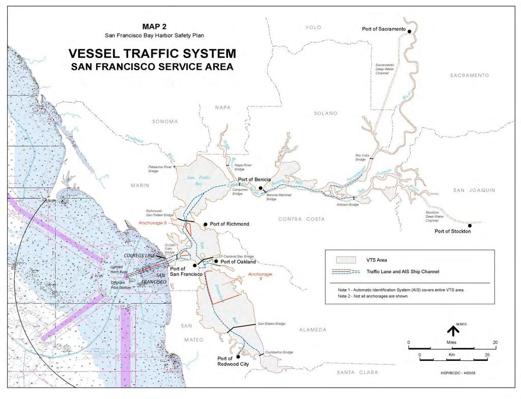
340 Map 2 331
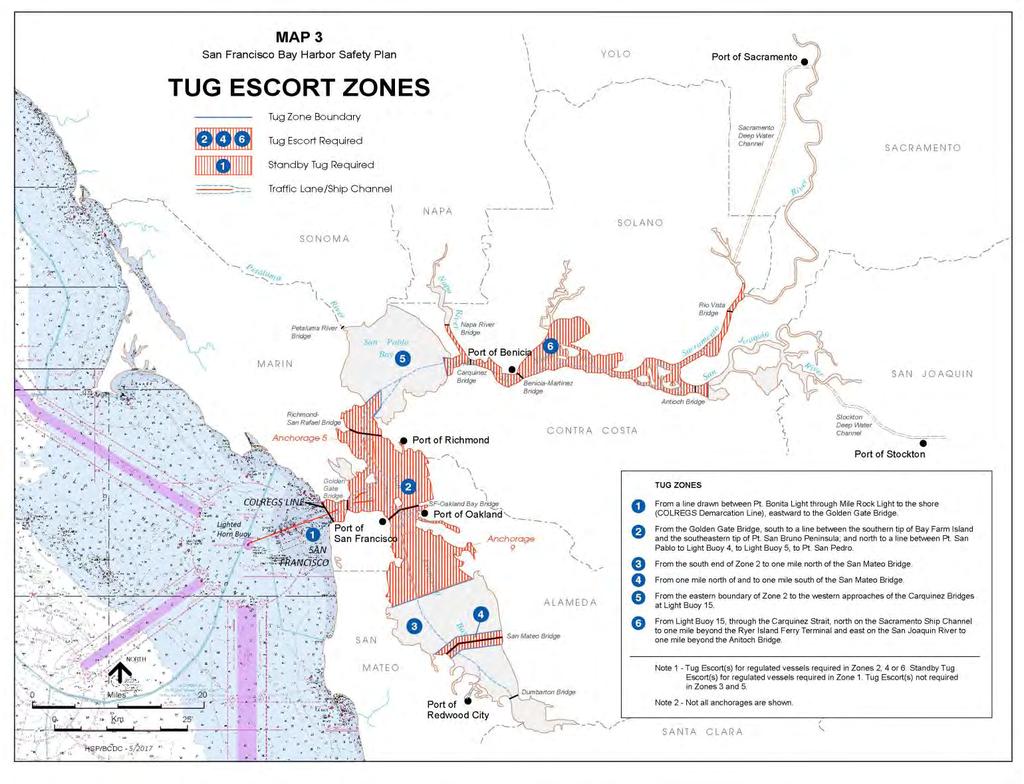
341 Map 3 332
SAN FRANCISCO, SAN PABLO AND SUISUN BAYS HARBOR SAFETY PLAN
 SAN FRANCISCO, SAN PABLO AND SUISUN BAYS HARBOR SAFETY PLAN Voted on and approved by the Harbor Safety Committee of the San Francisco Bay Region March 12, 2009 Pursuant to the California Oil Spill and
SAN FRANCISCO, SAN PABLO AND SUISUN BAYS HARBOR SAFETY PLAN
 SAN FRANCISCO, SAN PABLO AND SUISUN BAYS HARBOR SAFETY PLAN Voted on and approved by the Harbor Safety Committee of the San Francisco Bay Region June 9, 2011 Pursuant to the California Oil Spill and Prevention
The LA/LB Harbors handle more than 5,500 commercial vessel arrivals per year (excluding local coastwise and Catalina Island traffic).
.") X. SMALL CRAFT For the purpose of the Los Angeles and Long Beach Harbor Safety Plan, pleasure vessels, commercial fishing vessels and sportfishing boats are designated as small craft. A. BACKGROUND: The
X. SMALL CRAFT For the purpose of the Los Angeles and Long Beach Harbor Safety Plan, pleasure vessels, commercial fishing vessels and sportfishing boats are designated as small craft. A. BACKGROUND: The
MAC Transit Advisories as of April 30, 2018
 MAC Transit Advisories as of April 30, 2018 The Mariners Advisory Committee for the Bay and River Delaware was established in October 1964. Its members and associate members are mainly comprised of master
World Shipping Council. National Oceanographic and Atmospheric Administration
 Comments of the World Shipping Council Submitted to the National Oceanographic and Atmospheric Administration In the matter of Endangered and Threatened Species; Petition for Rulemaking to Establish a
Delaware River Vessel Reporting System Mariners Advisory Committee For
 Delaware River Vessel Reporting System Mariners Advisory Committee For the Bay and River Delaware The Mariner's Advisory Committee is comprised of Master Mariners, River Pilots, and concerns itself with
National Maritime Center
 National Maritime Center Providing Credentials to Mariners (Sample Examination) Page 1 of 8 Choose the best answer to the following Multiple Choice Questions. 1. Assume that your vessel has just entered
LOCAL NOTICE TO MARINERS
 USCG Notice to Mariners 3/7/18 (View full Notice here) LNM 10/18 Coast Guard District 1: U.S. Department of Homeland Security United States Coast Guard LOCAL NOTICE TO MARINERS COASTAL WATERS FROM EASTPORT,
International regulations and guidelines for maritime spatial planning related to safe distances to multiple offshore structures (e.g.
 International regulations and guidelines for maritime spatial planning related to safe distances to multiple offshore structures (e.g. wind farms) Introduction This is a summary of the most important international
Lecture Outlines PowerPoint. Chapter 15 Earth Science, 12e Tarbuck/Lutgens
 Lecture Outlines PowerPoint Chapter 15 Earth Science, 12e Tarbuck/Lutgens 2009 Pearson Prentice Hall This work is protected by United States copyright laws and is provided solely for the use of instructors
BookletChart. Entrance to San Francisco Bay NOAA Chart A reduced-scale NOAA nautical chart for small boaters
 BookletChart Entrance to San Francisco Bay NOAA Chart 18649 A reduced-scale NOAA nautical chart for small boaters When possible, use the full-size NOAA chart for navigation. Included Area Published by
Required knowledge for Cook Strait endorsement
 Required knowledge for Cook Strait endorsement Last updated: March 2018 This document is uncontrolled if printed, please refer to the Maritime New Zealand website for the latest version. Cook Strait is
COAST GUARD ADVISORY NOTICE (CGAN ) To: Distribution Date: September 1, 2017
 To: Distribution Date: September 1, 2017") Commander United States Coast Guard Sector New York 212 Coast Guard Drive Staten Island, NY 10305 Staff Symbol: (spw) Phone: (718) 354-2353 Fax: (718) 354-4190 COAST GUARD ADVISORY NOTICE (CGAN 2017-016)
Commander United States Coast Guard Sector New York 212 Coast Guard Drive Staten Island, NY 10305 Staff Symbol: (spw) Phone: (718) 354-2353 Fax: (718) 354-4190 COAST GUARD ADVISORY NOTICE (CGAN 2017-016)
UNITED NEW YORK SANDY HOOK PILOTS BENEVOLENT ASSOCIATION AND UNITED NEW JERSEY SANDY HOOK PILOTS BENEVOLENT ASSOCIATION
 UNITED NEW YORK SANDY HOOK PILOTS BENEVOLENT ASSOCIATION AND UNITED NEW JERSEY SANDY HOOK PILOTS BENEVOLENT ASSOCIATION TO: All Shipping Agents and Interested Parties January 19, 2017 SUBJECT: Anchorage
Severe Weather Planning Information. Maritime Stakeholders
 Severe Weather Planning Information for the Maritime Stakeholders Port Arthur Captain of the Port Zone Sabine-Neches Waterway, Calcasieu Waterway and Gulf Intracoastal Waterway Revised: May 2018 INTRODUCTION
Chapter 10 Lecture Outline. The Restless Oceans
 Chapter 10 Lecture Outline The Restless Oceans Focus Question 10.1 How does the Coriolis effect influence ocean currents? The Ocean s Surface Circulation Ocean currents Masses of water that flow from one
3.7 VESSEL TRANSPORTATION Environmental Setting Area of Influence Setting. Vessel Transportation Service
 3.7.1 Environmental Setting 3.7.1.1 Area of Influence The vessel transportation analysis covers the waters serving POLB, and the San Pedro Bay, which is shared with POLA. This analysis considers the shipping
HELSINKI COMMISSION HELCOM SAFE NAV 4/2014 Group of Experts on Safety of Navigation Fourth Meeting Helsinki, Finland, 4 February 2014
 HELSINKI COMMISSION HELCOM SAFE NAV 4/2014 Group of Experts on Safety of Navigation Fourth Meeting Helsinki, Finland, 4 February 2014 Agenda Item 3 Accidents and ship traffic in the Baltic Sea Document
Marine Safety Information Bulletin COAST GUARD GUIDANCE FOR DEAD SHIP MOVEMENT IN SECTOR HONOLULU CAPTAIN OF THE PORT ZONE.
 Marine Safety Information Bulletin 16-002 U.S. DEPARTMENT OF HOMELAND SECURITY U. S. Coast Guard Sector Honolulu Sand Island Parkway Honolulu, Hawaii 96819 (808) 842-2600 COAST GUARD GUIDANCE FOR DEAD
GENERAL GUIDELINES FOR VESSELS TRANSITING RESTRICTED WATERWAYS OR PORTS
 GENERAL GUIDELINES FOR VESSELS TRANSITING RESTRICTED WATERWAYS OR PORTS Revised: March 5, 2018 TABLE OF CONTENTS GENERAL DEFINITIONS... 2 VESSEL SPACING... 3 HORIZONTAL CLEARANCE... 3 UNDER-KEEL CLEARANCE
This direction contains the requirements for the compulsory pilotage areas within the Auckland region. This
 Harbourmaster s Direction 2-15 Pilotage Foreword This direction contains the requirements for the compulsory pilotage areas within the Auckland region. This direction updates and supersedes previous Harbourmaster
APPENDIX G WEATHER DATA SELECTED EXTRACTS FROM ENVIRONMENTAL DATA FOR BCFS VESSEL REPLACEMENT PROGRAM DRAFT REPORT
 APPENDIX G WEATHER DATA SELECTED EXTRACTS FROM ENVIRONMENTAL DATA FOR BCFS VESSEL REPLACEMENT PROGRAM DRAFT REPORT Prepared for: B.C. Ferries Services Inc. Prepared by: George Roddan, P.Eng. Roddan Engineering
THE REPUBLIC OF LIBERIA LIBERIA MARITIME AUTHORITY
 THE REPUBLIC OF LIBERIA LIBERIA MARITIME AUTHORITY 8619 Westwood Center Drive Suite 300 Vienna, Virginia 22182, USA Tel: +1 703 790 3434 Fax: +1 703 790 5655 Email: safety@liscr.com Web: www.liscr.com
Harbourmaster s Office Operation of Superyacht in the Auckland Region Navigation Safety Operating Requirements
 Harbourmaster s Office Operation of Superyacht in the Auckland Region Navigation Safety Operating Requirements Foreword Maritime Rule 90 requires that every vessel of 500 Gross tonnage or greater carries
Coastal and marine recreation in New England is ingrained in the region s economic and
 RECREATION Coastal and marine recreation in New England is ingrained in the region s economic and social fabric. Recreation on the ocean and coast includes many of New Englanders most time-honored and
Vessel Traffic in the Salish Sea Mitigating Risk... Captain Joe Raymond Coast Sector Puget Sound
 Vessel Traffic in the Salish Sea Mitigating Risk.... Captain Joe Raymond Coast Sector Puget Sound Overview Prevention Waterways Management Oil Spill Data Mitigating Risks Sector Puget Sound AOR Blan k
COOPERATIVE VESSEL TRAFFIC SERVICE (CVTS) TAMPA BAY, FLORIDA
 TAMPA BAY, FLORIDA") COOPERATIVE VESSEL TRAFFIC SERVICE (CVTS) TAMPA BAY, FLORIDA USERS MANUAL Oct 2010 1 st Edition Serving the Port of Tampa, Port Manatee, Port of Saint Petersburg, and the Waterways of Tampa Bay 1 Table
COOPERATIVE VESSEL TRAFFIC SERVICE (CVTS) TAMPA BAY, FLORIDA USERS MANUAL Oct 2010 1 st Edition Serving the Port of Tampa, Port Manatee, Port of Saint Petersburg, and the Waterways of Tampa Bay 1 Table
GUIDELINES FOR NAVIGATION UNDER THE CONFEDERATION BRIDGE
 (12/2009) GUIDELINES FOR NAVIGATION UNDER THE CONFEDERATION BRIDGE REVISION 1 DECEMBER 2009 Responsible Authority The Regional Director Marine Safety Atlantic Region is responsible for this document, including
SAN DIEGO HARBOR SAFETY PLAN Approved January 2015
 SAN DIEGO HARBOR SAFETY PLAN Approved January 2015 Mandated by California Oil Spill Prevention and Response Act of 1990 Notice of Disclaimer of Liability: This publication is not intended for navigational
World Shipping Council. Bureau of Ocean Energy Management Department of the Interior
 Comments of the World Shipping Council Submitted to the Bureau of Ocean Energy Management Department of the Interior In the matter of Commercial Leasing for Wind Power Development on the Outer Continental
WORK-REST REQUIREMENTS FOR PILOTS
 AN ORDER OF THE BOARD OF PILOT COMMISSIONERS FOR THE PORT OF CORPUS CHRISTI AUTHORITY REGARDING WORK-REST REQUIREMENTS FOR PILOTS AND COMBINED BEAM RESTRICTION Whereas, the current Rules and Regulations
National Maritime Center
 National Maritime Center Providing Credentials to Mariners Q301 Rules of the Road-Inland (Sample Examination) Page 1 of 19 Choose the best answer to the following Multiple Choice Questions. NO reference
properly applied assessment in the use.1 landmarks.1 approved in-service of ECDIS is not experience The primary method of fixing required for those
 STCW Code Table A-II/3 Specification of minimum standard of for officers in charge of a navigational watch and for masters on ships of less than 500 gross tonnage engaged on near-coastal voyages Ref: https://www.edumaritime.net/stcw-code
ANCHORING. Small Craft Advisories (sustained winds 21 to 33 knots
 SOC Quick Reference ANCHORING Risk General Information All Puget Sound regions other than Smith Cove East and West in Elliott Bay and Commencement Bay All Weather Visibility Gale Warnings (sustained winds
National Maritime Center
 National Maritime Center Providing Credentials to Mariners (Sample Examination) Page 1 of 12 Choose the best answer to the following Multiple Choice Questions. 1. An alternating light. (A) shows a light
BookletChart. Sand Key to Rebecca Shoal NOAA Chart A reduced-scale NOAA nautical chart for small boaters
 BookletChart Sand Key to Rebecca Shoal NOAA Chart 11439 A reduced-scale NOAA nautical chart for small boaters When possible, use the full-size NOAA chart for navigation. Published by the National Oceanic
BookletChart. Intracoastal Waterway Matecumbe to Grassy Key NOAA Chart A reduced-scale NOAA nautical chart for small boaters
 BookletChart Intracoastal Waterway Matecumbe to Grassy Key NOAA Chart 11449 A reduced-scale NOAA nautical chart for small boaters When possible, use the full-size NOAA chart for navigation. Published by
Wexford Harbour. Yachting Guide. Navigation
 Wexford Harbour Yachting Guide Navigation This document supersedes all previous editions. Approvals: Yacht Club Committee April, 2015 Wexford Board of Directors April, 2015 # Date Section Revision 1 6.5.2015
Rules Practice Exam 11
 1 BOTH INTERNATIONAL & INLAND While underway in fog, you hear a vessel sound one prolonged blast followed by two short blasts on the whistle. What does this signal indicate? A. A vessel towing B. A vessel
Pilotage Directions 2017
 Pilotage Directions 2017 1. Commencement These Pilotage Directions shall come into force on 31 st August 2017 on which date the existing Pilotage Directions are revoked. 2. Short Title These Pilotage Directions
APC Operating Procedures Oil Tankers
 APC Operating Procedures Oil Tankers August 2013 The APC Operating Procedures were developed to aid the Master and Operator of oil tankers in ensuring all aspects of the APC are complied with when transiting
3.9 Marine Transportation
 3.9 Marine Transportation 3. Affected Environment and Environmental Analysis 3.9 Marine Transportation 3.9.1 Introduction This section describes existing marine vessel transportation within the Port, the
LOCAL NOTICE TO MARINERS
 USCG Notice to Mariners 3/26/15 (View full Notice here) LNM 12/15 Coast Guard District 1 : U.S. Department of Homeland Security United States Coast Guard LOCAL NOTICE TO MARINERS COASTAL WATERS FROM EASTPORT,
Forth Ports Limited. Port of Dundee. Marine Guidelines and Port Information
 Forth Ports Limited Port of Dundee Marine Guidelines and Port Information LIST OF AMENDMENTS DATE PAGE NUMBER 22 NEW EDITION 7 March 2016 Ruling Depths 18 23 rd Application updated 3 23 rd - Tug fleet
IMO RESOLUTION A.960(23) Adopted 5 December 2003 (Agenda item 17)
 Adopted 5 December 2003 (Agenda item 17)") INTERNATIONAL MARITIME ORGANIZATION E IMO ASSEMBLY 23rd session Agenda item 17 A 23/Res.960 5 March 2004 Original: ENGLISH RESOLUTION A.960(23) Adopted 5 December 2003 (Agenda item 17) RECOMMENDATIONS
INTERNATIONAL MARITIME ORGANIZATION E IMO ASSEMBLY 23rd session Agenda item 17 A 23/Res.960 5 March 2004 Original: ENGLISH RESOLUTION A.960(23) Adopted 5 December 2003 (Agenda item 17) RECOMMENDATIONS
World Shipping Council. Bureau of Ocean Energy Management U.S. Department of the Interior
 Comments of the World Shipping Council Submitted to the Bureau of Ocean Energy Management U.S. Department of the Interior In the matters of Commercial Leasing for Wind Power Development on the Outer Continental
Harbourmaster s Office Tamaki River. Navigation Safety Operating Requirements 2014
 Harbourmaster s Office Tamaki River Navigation Safety Operating Requirements 2014 Auckland Council Harbourmaster s Office TAMAKI RIVER Navigation Safety Operating Requirements FOREWARD The purpose of these
An Introduction To Marine Charts
 An Introduction To Marine Charts //captnmike.com Revised August 29, 2011 An Illustrated introduction to U. S. Aids to Navigation in the Shilshole Bay area of Puget Sound, Washington. The chart symbols
Commandant United States Coast Guard NAVIGATION AND VESSEL INSPECTION CIRCULAR NO. 2-97, CHANGE 1
 Commandant United States Coast Guard 200 Second Street, S.W. Washington, DC 20593-000 Staff Symbol: G-MOC Phone: 202-267-464 A DISTRIBUTION SDL No. 34 a b c d e f g h I j k l m n o p q r s t u v w x y
Forth Ports Limited. Port of Dundee. Rig Move Guidelines
 Forth Ports Limited Port of Dundee Contents 1 Introduction... 4 2 Pre-Arrival... 4 2.1 Planning Meetings... 4 2.2 Priority of Movements... 4 2.3 Confirmation/Cancellations... 5 2.4 Weather Parameters...
Visiting Lake Macquarie
 Visiting Lake Macquarie Lake Macquarie is the largest coastal salt water lake in Australia and is a prime boating destination for both small and large vessels. Many sailing regattas and fishing activities
GENERAL LIMITATIONS AND RESTRICTIONS. LNGC Temporary Exemption (Effective August 21, 2018)
") RULES AND REGULATIONS GOVERNING PILOTS AND PILOTAGE ON THE CORPUS CHRISTI SHIP CHANNEL EFFECTIVE AUGUST 1, 2013 AMENDED EFFECTIVE MAY 13, 2014 AMENDED EFFECTIVE OCTOBER 1, 2014 AMENDED EFFECTIVE JANUARY
RULES AND REGULATIONS GOVERNING PILOTS AND PILOTAGE ON THE CORPUS CHRISTI SHIP CHANNEL EFFECTIVE AUGUST 1, 2013 AMENDED EFFECTIVE MAY 13, 2014 AMENDED EFFECTIVE OCTOBER 1, 2014 AMENDED EFFECTIVE JANUARY
TICES TO MARINERS 1 TO 46 ANNUAL EDITION 2018 SECTION A AIDS TO NAVIGATION AND MARINE SAFETY
 A5 NAVIGATION SAFETY 10 Routeing of Ships 1 GENERAL 1.1 Rule 10 of the Collision Regulations applies to all ships navigating in or near a routeing system. 1.2 The information on ships' routeing in this
MARINER S GUIDE TO THE FORTH
 MARINER S GUIDE TO THE FORTH INTRODUCTION 1. The Statutory Harbour Authority s area of jurisdiction on the River and Firth of Forth ( The Forth ) extends from approximately one mile west of the Isle of
PILOTAGE INFORMATION
 PILOTAGE INFORMATION Revised A PILOTAGE DIRECTIONS The Gloucester Harbour Trustees is the Competent Harbour Authority for the Gloucester Harbour under the Pilotage Act 1987 and responsible for the provision
ROUTEING MEASURES OTHER THAN TRAFFIC SEPARATION SCHEMES
 E 4 ALBERT EMBANKMENT LONDON SE1 7SR Telephone: +44 (0)20 7735 7611 Fax: +44 (0)20 7587 3210 SN.1/Circ.317 4 December 2012 ROUTEING MEASURES OTHER THAN TRAFFIC SEPARATION SCHEMES 1 The Maritime Safety
3.7 VESSEL TRANSPORTATION Environmental Setting Area of Influence Setting
 3.7 VESSEL TRANSPORTATION 3.7.1 Environmental Setting 3.7.1.1 Area of Influence The vessel transportation analysis covers the waters of San Pedro Bay, which includes the Pier S site. Given the proximity
APPENDIX D-2. Sea Level Rise Technical Memo
 APPENDIX D-2 Sea Level Rise Technical Memo 2185 N. California Blvd., Suite 500 Walnut Creek, CA 94596 (925) 944-5411 Fax: (925) 944-4732 www.moffattnichol.com DRAFT MEMORANDUM To: From: Neil Nichols,
Harbor Safety Committee HEAVY WEATHER (WX)
") HEAVY WEATHER (WX) SOC Quick Reference Risk Petroleum transfers Mooring buoys- Operating Policies and Weather Criteria General mooring policies, breakaway prevention Derelict and unattended vessels (abandoned
HEAVY WEATHER (WX) SOC Quick Reference Risk Petroleum transfers Mooring buoys- Operating Policies and Weather Criteria General mooring policies, breakaway prevention Derelict and unattended vessels (abandoned
General Directions for Navigation in the Forth
 General Directions for Navigation in the Forth Forth Ports Limited, in exercise of their powers under section 3 of the Forth Ports Authority Order 1980 and having carried out the consultations required
VESSEL TRANSIT SCHEDULING AT THE PANAMA CANAL NUMBER AND ORDER OF VESSELS IN THE SCHEDULE
 VESSEL TRANSIT SCHEDULING AT THE PANAMA CANAL This document intends to provide our clients with a better understanding of vessel scheduling in the Panama Canal. For any questions not addressed in this
2005 ABC. Chapter 3 Part 2. Navigating with ATON's. Revision to D-13 Local Notes. Instructor Notes for Mike Brough. Mike Brough
 2005 ABC Chapter 3 Part 2 Navigating with ATON's Revision to D-13 Local Notes Instructor Notes for Mike Brough Mike Brough June 24 2008 June 24 2008 Slide 1 June 24 2008 New graphics Navigating on Water
GENERAL LIMITATIONS AND RESTRICTIONS. Draft Restrictions
 RULES AND REGULATIONS GOVERNING PILOTS AND PILOTAGE ON THE CORPUS CHRISTI SHIP CHANNEL EFFECTIVE AUGUST 1, 2013 AMENDED EFFECTIVE MAY 13, 2014 AMENDED EFFECTIVE OCTOBER 1, 2014 I GENERAL The Rules and
You must stop your. pass with caution on the port side of vessel "B" The vessel moving upstream against the current
 BK NUM ANS QUESTION ANSWER A ANSWER B ANSWER C ANSWER D ILLUST 1 1 C 1 2 B INLAND ONLY You are navigating in a narrow channel and must remain in the channel for safe operation. Another vessel is crossing
National Maritime Center
 National Maritime Center Providing Credentials to Mariners (Sample Examination) Page 1 of 16 Choose the best answer to the following Multiple Choice Questions. 1. On U.S. charts, you can tell if a named
Rules Practice Exam 14
 1 BOTH INTERNATIONAL & INLAND Additional light signals are provided in the Annexes to the Rules for vessels. A. engaged in fishing B. not under command C. engaged in towing D. under sail 2 BOTH INTERNATIONAL
AK-APC-NTV Operating Procedures for Cargo and Passenger Non Tank Vessels Transiting and Operating in Alaska Waters December 26, 2015
 AK-APC-NTV Operating Procedures for Cargo and Passenger Non Tank Vessels Transiting and Operating in Alaska Waters December 26, 2015 The Alternative Planning Criteria (APC) Operating Procedures were developed
Code Of Practice For Towage Operations In The Port of St Helier (Towage Guidelines)
") Code Of Practice For Towage Operations In The Port of St Helier (Towage Guidelines) This Code Covers The Use Of Tugs And Towage In The Port Of St Helier Page number Contents 2 Introduction 3 Communication
Code Of Practice For Towage Operations In The Port of St Helier (Towage Guidelines) This Code Covers The Use Of Tugs And Towage In The Port Of St Helier Page number Contents 2 Introduction 3 Communication
Rules Practice Exam 12
 1 INLAND ONLY You are on vessel "A", and vessel "B" desires to overtake you on your starboard side as shown. After the vessels have exchanged one blast signals, you should. Diagram 31 A. alter course to
BookletChart. Chesapeake Bay Tangier Sound, Northern Part NOAA Chart A reduced-scale NOAA nautical chart for small boaters
 BookletChart Chesapeake Bay Tangier Sound, Northern Part NOAA Chart 12231 A reduced-scale NOAA nautical chart for small boaters When possible, use the full-size NOAA chart for navigation. Published by
Chittagong, Bangladesh (Asia Region)
") General Information: Port Information (Asia Region) Extract of port information from Chittagong Port Authority: The Port of Chittagong is the principal Port of the People's Republic of Bangladesh. It is
General Information: Port Information (Asia Region) Extract of port information from Chittagong Port Authority: The Port of Chittagong is the principal Port of the People's Republic of Bangladesh. It is
SECTION SUMMARY. Section 3.10 Marine Transportation
 Section.0 Marine Transportation 0 0 0 SECTION SUMMARY This section describes existing marine transportation within the Port and identifies potential impacts to marine transportation including navigation
ADANI PORTS & SEZ LTD. ++ MUNDRA PORT ++ GENERAL INFORMATION
 ADANI PORTS & SEZ LTD. ++ MUNDRA PORT ++ GENERAL INFORMATION LOCATION Mundra Port is all weather, independent, commercial port with geographical and hydrological advantages on the West Coast of India,
Rules Practice Exam 7
 1 INTERNATIONAL ONLY The light which may be used with a vessel's whistle is to be. A. used when the whistle is broken B. used prior to sounding the whistle C. used only at night D. a white light 2 INTERNATIONAL
Introduction of the term Traffic Control Zone and formalization of Fraser River Traffic Control Zone procedures
 Consideration Report Introduction of the term Traffic Control Zone and formalization of Fraser River Traffic Control Zone procedures Background Under the Canada Marine Act, all Canada Port Authorities
DUBLIN PORT COMPANY PILOTAGE BYE-LAWS. 1st July Dublin Port Company Pilotage Bye-Laws, 1 st July 2018 Page 1
 DUBLIN PORT COMPANY PILOTAGE BYE-LAWS 1st July 2018 Dublin Port Company Pilotage Bye-Laws, 1 st July 2018 Page 1 Contents PILOTAGE BYE-LAWS... 3 1) Interpretation... 3 2) Compulsory Pilotage and Exempted
All comments received will be taken into consideration before the proposed amendments are implemented.
 Notice of Amendment Port Information Guide Notification date: February 13 th, 2018 Preamble In accordance with the Canada Marine Act, 1998, Section 57 Notice, the Vancouver Fraser Port Authority is proposing
U. S. Coast Guard Sector Boston Merrimack River Approach and Entrance, MA. Waterways Management Survey
 U. S. Coast Guard Sector Boston Merrimack River Approach and Entrance, MA. Waterways Management Survey The Waterways Analysis and Management Survey (WAMS) process is an essential component of both the
National Maritime Center
 National Maritime Center Providing Credentials to Mariners Able Seaman Unlimited, Limited, Special, Special OSV, Sail, Fishing Industry (Sample Examination) Page 1 of 17 Choose the best answer to the following
SECTION 3.6 VESSEL TRANSPORTATION
 3.6 VESSEL TRANSPORTATION The vessel transportation analysis assesses the waters serving Channels 2 and 3, the POLB, and San Pedro Bay. Given the proximity of the Project to the POLA, the vessel transportation
Figure 4, Photo mosaic taken on February 14 about an hour before sunset near low tide.
 The Impact on Great South Bay of the Breach at Old Inlet Charles N. Flagg and Roger Flood School of Marine and Atmospheric Sciences, Stony Brook University Since the last report was issued on January 31
The ocean water is dynamic. Its physical
 CHAPTER MOVEMENTS OF OCEAN WATER The ocean water is dynamic. Its physical characteristics like temperature, salinity, density and the external forces like of the sun, moon and the winds influence the movement
LOWER MISSISSIPPI RIVER PRE-ENTRY INFORMATION
 LOWER MISSISSIPPI RIVER PRE-ENTRY INFORMATION Notice of Arrivals Prior to Arrival at any U.S. port, the vessel master should ensure a complete and accurate Notice of Arrival has been submitted to National
Preventing Damage to Harbour Facilities and. Ship Handling in Harbours PART 2 INDEX
 Preventing Damage to Harbour Facilities and Ship Handling in Harbours PART 2 INDEX 1 Vessel handling is based on the basic knowledge that a vessel floats in the water and returns to its original position
Chapter 22, Section 1 - Ocean Currents. Section Objectives
 Chapter 22, Section 1 - Ocean Currents Section Objectives Intro Surface Currents Factors Affecting Ocean Currents Global Wind Belts (you should draw and label a diagram of the global wind belts) The Coriolis
PILOTAGE DIRECTIONS REVIEWED DECEMBER 2016
 PILOTAGE DIRECTIONS REVIEWED DECEMBER 2016 REVISION LIST Revision No. Date Details Approved by: Original All sections 12 Dec 2013 First edition of C W Brand v1.0 Pilotage Directions Revision 2 all sections
How To Enter Kushiro Port and Things To Be Aware of When Entering
 How To Enter Kushiro Port and Things To Be Aware of When Entering 1.How to enter Kushiro Port (1)How to enter the East Area When entering the port from Nemuro, navigate while maintaining a safe distance
INTRODUCTION TO COASTAL ENGINEERING AND MANAGEMENT
 Advanced Series on Ocean Engineering Volume 16 INTRODUCTION TO COASTAL ENGINEERING AND MANAGEMENT J. William Kamphuis Queen's University, Canada World Scientific Singapore New Jersey London Hong Kong Contents
NavRule Practice Exam, 70 Series Practice April 18, Labeled C have been copied to collection
 1C. INTERNATIONAL & INLAND There are two classes of vessel which, to the extent necessary to carry out their work, do not have to comply with the rule regarding traffic separation schemes. One of these
RESOLUTION MSC.161(78) (adopted on 17 May 2004) AMENDMENTS TO THE EXISTING MANDATORY SHIP REPORTING SYSTEM "THE TORRES STRAIT AND INNER ROUTE OF THE
 (adopted on 17 May 2004) AMENDMENTS TO THE EXISTING MANDATORY SHIP REPORTING SYSTEM THE TORRES STRAIT AND INNER ROUTE OF THE") MSC 78/26/Add.2 RESOLUTION MSC.161(78) REPORTING SYSTEM THE TORRES STRAIT AND INNER ROUTE OF THE GREAT BARRIER REEF THE MARITIME SAFETY COMMITTEE, RECALLING Article 28(b) of the Convention on the International
MSC 78/26/Add.2 RESOLUTION MSC.161(78) REPORTING SYSTEM THE TORRES STRAIT AND INNER ROUTE OF THE GREAT BARRIER REEF THE MARITIME SAFETY COMMITTEE, RECALLING Article 28(b) of the Convention on the International
EBA Position Statement AIS Virtual Aids to Navigation
 EBA Position Statement AIS Virtual Aids to Navigation Document date: 17 October 2015 Latest update: 9 December 2015 Executive Summary The European Boating Association 1 (EBA) recognises the value of Automatic
SAFE PASSAGE THE STRAITS OF MALACCA AND SINGAPORE. CF6-6.7.a the 6 th Co-Operation Forum 7-8 October 2013, Bali, Indonesia DRAFT CONTENT TEXT
 CF6-6.7.a the 6 th Co-Operation Forum 7-8 October 2013, Bali, Indonesia DRAFT CONTENT TEXT VER. 24 September 2013 SAFE PASSAGE THE STRAITS OF MALACCA AND SINGAPORE 1 INTRODUCTION Today, the Straits of
Air Masses and Fronts
 Air Masses and Fronts A huge body of air that has similar temperature, humidity, and air pressure at any given height is called an air mass. A single air mass may spread over millions of square kilometers
Task 16: Impact on Lummi Cultural Properties
 Gateway Pacific Terminal Vessel Traffic and Risk Assessment Study Task 16: Impact on Lummi Cultural Properties Prepared for Pacific International Terminals, Inc. Prepared by The Glosten Associates, Inc.
SS&S Chapter 8 Instructor Guide
 SS&S Chapter 8 Instructor Guide The Rules of the Nautical Road The PowerPoints (PPT) slides for this SS&S chapter were copied from the BS&S-13 th Ed PPT because they are identical. Only the chapter numbers
Towed Barge Standard of Care
 Lower Columbia Region Harbor Safety Committee Towed Barge Standard of Care Page 1 of 6 A. 1. Purpose The Columbia River is intended to eliminate conflicts between towing vessels conducting astern towing
Berkeley Island Marine Pre-Rental Instructions. If you do not have a
 Berkeley Island Marine Pre-Rental Instructions. If you do not have a safe boating certificate or a boat license in the state of NJ, or an equivalent in another state, you must take this instruction. Approximate
The Impact on Great South Bay of the Breach at Old Inlet Charles N. Flagg School of Marine and Atmospheric Sciences, Stony Brook University
 The Impact on Great South Bay of the Breach at Old Inlet Charles N. Flagg School of Marine and Atmospheric Sciences, Stony Brook University The previous report provided a detailed look at the conditions
UBCM Community Excellence Awards 2007 Submission
 UBCM Community Excellence Awards 2007 Submission Formatted: Left: 2.54 cm Category: Partnerships Project: Implementation of False Creek Anchoring Management System 1. A one-paragraph summary of the project/program
TITLE: The Importance of Model Validation: Two Case Studies. AUTHOR:Julie Thomas. Scripps Institution of Oceanography, La Jolla, CA.
 TITLE: The Importance of Model Validation: Two Case Studies AUTHOR:Julie Thomas Scripps Institution of Oceanography, La Jolla, CA jothomas@ucsd.edu CO-AUTHOR: Corey Olfe Scripps Institution of Oceanography,