Leeuwin Current - Reading
|
|
|
- Annabelle Green
- 6 years ago
- Views:
Transcription
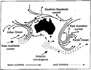
1 Leeuwin Current At 5,500 kilometres, the Leeuwin is our longest ocean current! One of Australia s most influential natural features, the Leeuwin Current, has been confirmed as the longest continuous coastal current system in the world. Marine scientists have linked what was originally thought of as three separate coastal currents, with the same oceanographic signature, from Western Australia s North West Shelf to South Cape in southern Tasmania. "The intriguing aspect is that the current remains connected at all because very different factors must act together with perfect timing. large-scale circulation in the Indian Ocean sets up the flow off WA and delivers it to the south coast, just as the seasonal winds change direction and push it further to the east The Leeuwin is one of four currents influencing life in the Australian region, by regulating rainfall and temperature, fostering coastal recreation and distributing marine species currents and associated ocean eddies, which spin from it, govern nutrient distribution to the food chain and distribution of larvae from seafood species such as salmon and the western and south-eastern rock lobsters The Leeuwin originates near North West Cape in Western Australia and flows southward towards Cape Leeuwin before turning eastwards into the Great Australian Bight From south-eastern South Australia it was known as the South Australian Current and flowed to north western Tasmania It then turned south again down the Tasmanian west coast to become the Zeehan Current, reaching as far as South Cape and in winter flows north as far as the Freycinet Peninsula This current had been shown, in earlier research, to be vital to a range of ecological mechanisms; it provides a free ride for many marine species, assisting their migration and subsequent distribution, from the tropical north to the temperate southern waters.

2 Australia is influenced by four major ocean currents: The Leeuwin Current The East Australian Current southward flowing from near Fraser Island to Tasmania The Indonesian Through flow a system of westward flowing currents from the Pacific to the Indian Ocean The Antarctic Circumpolar Current the world s largest ocean current and considered the powerhouse for global climate.
3 The Leeuwin Current takes an opposite course to geographically-similar currents which flow northward up the African (Benguela) and South American (Humboldt) continents. Partly formed from the system of currents draining the Pacific Ocean into the Indian Ocean, through Indonesia, its characteristics are detectable throughout the course of its long winter journey The journey is governed by seasonal conditions and prevailing winds, with the current generally following the edge of the continental shelf The southward flow of the Leeuwin is weakest from November to March when the winds tend to blow strongly northwards and reaches its greatest flow in autumn and winter, when the opposing winds are weakest. The Leeuwin Current is about 300 m deep (quite shallow for a major current system, by global standards), and beneath it is a northwards counter-current called the Leeuwin Undercurrent


4 SEC - South Equatorial Current: SEC South Equatorial Current BSW Bass Strait Waters EAC East Australian Current LC Leeuwin Current IOI Indian Ocean Inflow TF Tasman Front SAW Subantarctic Waters

5 Map of the World s Ocean Currents:

6 When it rains, blame ocean currents: Indian Ocean currents influence rainfall in Australia and Indonesia Potentially the biggest payoff of these findings will be its use with atmospheric data to better predict major weather events, including El Nino and La Nina phenomena, which have devastated communities over ages with droughts, floods and fires Near the end of each year, as the southern hemispherical summer is about to peak, a weak, warm counter-current flows southward along the coasts of Ecuador and Peru, replacing the cold Peruvian current. Centuries ago the local residents named this annual event El Niño (Spanish for "the child"), based on Christian theology. Normally, these warm counter-currents last for, at most, a few weeks when they again give way to the cold Peruvian flow However, every three to seven years, this counter-current is unusually warm and strong. Accompanying this event is a pool of warm, ocean surface water in the central and eastern Pacific Forces Causing Surface Currents: Winds blowing across the surface of the ocean create friction that sets water in motion. Motion is a function of wind speed and, consequently, of the energy transferred to the ocean's surface (e.g. a 15m/s wind may create only a 0.5m/s current). Winds moving across the ocean surface also raise sea level downwind. The surface of the tropical Pacific is 50cm higher off Asia than off South America.
![The Peruvian (Humboldt) Current: The cold Peruvian current (an eastern boundary current) flows towards the equator, along the coast of Ecuador and Peru. It flows with a speed of 0.1 to 0.15[m/s].](/docs-images/75/72225081/images/7-0.jpg "As an eastern boundary current it is slow and thus not very strong. Near the coast, it is only about 200m deep, while increasing to 700m offshore.")
7 The Peruvian (Humboldt) Current: The cold Peruvian current (an eastern boundary current) flows towards the equator, along the coast of Ecuador and Peru. It flows with a speed of 0.1 to 0.15[m/s]. As an eastern boundary current it is slow and thus not very strong. Near the coast, it is only about 200m deep, while increasing to 700m offshore. In the absence of an El Niño, prevailing surface winds cause Ekman transport away from the coast, with subsequent upwelling. This upwelling of deep, nutrient-filled waters is the primary food source for millions of fish, particularly anchovies along the Pacific Coast of South America. 1. Upwelling commonly occurs in the eastern regions of the oceans 2. In the Southern Hemisphere the winds must blow north for upwelling to occur (usually happens during the northern winter) 3. Coastal upwelling of this sort takes place because the South-American west coast sharply drops off to considerable depths. Prevailing, converging westward surface winds causes the water beneath to converge as well 4. Where water parcels meet in a convergence, they form a slight hill, thickening the surface layer 5. The mixed water is usually of higher density than the surrounding water, and consequently it sinks 6. Because the Peruvian current steadily feeds its waters into the westward surge, it creates an equatorial divergence zone 7. In such a divergence, the surface waters move away from one another causing deeper waters to move up to the surface 8. This action thins the surface layer and usually (adiabatically) lowers its temperature further

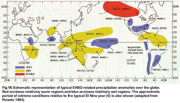
8 Major El Niño events related to large-scale atmospheric circulation: Each time an El Niño occurs, the barometric pressure drops over large portions of the southeastern Pacific, whereas in the western Pacific, near Indonesia and northern Australia, the pressure rises. As a major El Niño event comes to an end, the atmospheric pressure difference between these two regions swings back in the opposite direction. This see-saw pattern of atmospheric pressure between the eastern and western Pacific is known as the "Southern Oscillation". parts of the Pacific Ocean are characterized by high airpressure systems and low rainfall equatorial regions of the Indian Ocean are, at the same time, characterized by low air pressure and abundant rainfall The existing high pressure system in the eastern Pacific forces trade winds to blow toward the moist, lowpressure system residing over Indonesia These westward trade winds maintain the ocean surfacecurrents moving towards Indonesia and cause water to pile up in the western Pacific, causing the sea level in southeast Asia to rise as much as 46cm higher than along the west coast of South America In the months preceding an El Niño event, the normal weather pattern breaks down

9 Effects of El Niño: marked by abnormal weather patterns that drastically affect the economies of Ecuador and Peru abnormally strong winds, originating from the west push masses of warm surface water from the equatorial region against the South-American coast, and are ultimately deflected towards Mexico, Peru, and Ecuador, creating an area of warm water thousands of kilometers in length mixed layers deepen, and the deeper cold waters are buried underneath sun warms the surface layer still further, thus enhancing the effect thermocline falls, and along with it the pool of nutrient rich water in an immediate effect, this warm blob of water blocks off the upwelling of colder, nutrient rich water driving anchovies into starvation in a long-lasting ENSO event, the dissolved seawater oxygen content becomes depleted. This favours production of foul-smelling hydrogen-sulfide and other gases, blackening the "lead paint" on ships and producing other discolouring effects (Callao Painter) at the same time, some inland areas that are normally arid receive an uncommon abundance of rain here pastures and cotton fields have yields far above the norm. These climatic fluctuations have been known for years, but were always considered local phenomena El Niño is part of the global circulation and affects the weather patterns far beyond Peru or Ecuador
10

11 El Niño - a sustained warming, in excess of 1 C above normal, of the central and eastern tropical Pacific ocean, typically centred around the NIÑO 3 region (see Fig. 20). This warming is usually accompanied by negative values of the SOI, a decrease in the strength of the Pacific Trade winds, and a reduction in rainfall over eastern and northern Australia, which often results in drought. The most recent strong El Niño began in Autumn 1997 and ended Autumn La Niña - a sustained cooling, in excess of 1 C below normal, of the central and eastern tropical Pacific Ocean, typically centred around the NIÑO 3 region (see Fig. 20). This cooling is usually accompanied by positive values of the SOI, an increase in the strength of the Pacific Trade winds and higher than normal rainfall over eastern and northern Australia, sometimes with serious flooding. The most recent strong La Niña was in 1988/89; a fairly weak event occurred in late 1995 and through much of Sea surface temperatures (SSTs) off the West Australian coast may also be useful in estimating the probability of rain over the continent. SSTs in summer and autumn have an effect on the probability of rainfall in early winter over parts of southern and eastern Australia, through the formation of north-west cloud-bands

12 1. Prevailing winds in the area of North West Cape are from the south-west 2. This has the effect of forcing surface waters offshore, in a process known as Ekman Transport (ET) 3. This facilitates upwelling, in which cold nutrient-rich waters from the deep Indian Ocean are brought to the surface, fuelling the production of phytoplankton 4. However, the antagonistic effect of the Leeuwin Current prevents this in La Nina years 5. In El Nino years, the Leeuwin Current is weaker, and there is more upwelling and hence higher phytoplankton production
 monsoon In the period December to March, the Tibetan region of Central Asia becomes the site of an intense high pressure")
13 In recent years two major regional influences on Australia's weather and climatic conditions have been identified. These are the: 1. strength of the winter Asian monsoon 2. phenomenon known as 'El Nino' or the 'Southern Oscillation' Asian (winter) monsoon In the period December to March, the Tibetan region of Central Asia becomes the site of an intense high pressure system (which means a strong high is located there most of the time). In the Northern Hemisphere, high pressure systems create clockwise spiralling winds. In some years this winter Asian monsoon (the summer one is based on a low pressure system in the same region, with winds moving in the reverse direction) is very strong. Figure 1 illustrates the winter Asian monsoon. When the winter Asian monsoon is strong, winds pass over the equator and reverse their direction of movement (due to the reversal of the Coriolis Effect when you cross the equator); these now north-westerly winds spill over into north-western Australia.

14 This happens in our summer months, and tends to push both rain-bearing winds and tropical cyclones into north-west Western Australia and adjacent parts of the Northern Territory. These conditions are likely to help create a 'big wet' in that part of the country, which is otherwise not strongly correlated with the effects of El Nino/La Nina. During the early- to mid-1970's a series of what are now recognised as La Nina years occurred, giving exceptionally high rainfall over much of eastern Australia at that time.
OCN 201 Lab Fall 2009 OCN 201. Lab 9 - El Niño
 OCN 201 Lab Fall 2009 OCN 201 Lab 9 - El Niño El Niño is probably one of the most widely publicized oceanic phenomena. If there s one single reason for that it s probably the fact that El Niño s presence
El Niño Lecture Notes
 El Niño Lecture Notes There is a huge link between the atmosphere & ocean. The oceans influence the atmosphere to affect climate, but the atmosphere also influences the ocean, which can also affect climate.
Lecture 24. El Nino Southern Oscillation (ENSO) Part 1
 Part 1") Lecture 24 El Nino Southern Oscillation (ENSO) Part 1 The most dominant phenomenon in the interannual variation of the tropical oceanatmosphere system is the El Nino Southern Oscillation (ENSO) over the
Lecture 24 El Nino Southern Oscillation (ENSO) Part 1 The most dominant phenomenon in the interannual variation of the tropical oceanatmosphere system is the El Nino Southern Oscillation (ENSO) over the
- terminology. Further Reading: Chapter 07 of the text book. Outline. - characteristics of ENSO. -impacts
 (1 of 14) Further Reading: Chapter 07 of the text book Outline - terminology - characteristics of ENSO -impacts (2 of 14) Today: Introduction We want to look at another source of variability in the atmosphere
CHAPTER 7 Ocean Circulation
 1 2 3 4 5 6 7 8 9 10 11 12 13 14 CHAPTER 7 Ocean Circulation Words Ocean currents Moving seawater Surface ocean currents Transfer heat from warmer to cooler areas Similar to pattern of major wind belts
Ocean Currents that Redistribute Heat Globally
 Ocean Currents that Redistribute Heat Globally Ocean Circulation Ocean Currents Fig. CO7 OCEAN CURRENTS Surface ocean currents are similar to wind patterns: 1. Driven by Coriolis forces 2. Driven by winds
Introduction to Oceanography OCE 1001
 Introduction to Oceanography OCE 1001 Lecture Notes Chantale Bégin & Jessica Fry Version 2.1 10. Ocean Circulation (Trujillo, Chapter 7) Major ocean currents are stable and predictable; they have been
Lecture 13 El Niño/La Niña Ocean-Atmosphere Interaction. Idealized 3-Cell Model of Wind Patterns on a Rotating Earth. Previous Lecture!
 Lecture 13 El Niño/La Niña Ocean-Atmosphere Interaction Previous Lecture! Global Winds General Circulation of winds at the surface and aloft Polar Jet Stream Subtropical Jet Stream Monsoons 1 2 Radiation
The General Circulation and El Niño. Dr. Christopher M. Godfrey University of North Carolina at Asheville
 The General Circulation and El Niño Dr. Christopher M. Godfrey University of North Carolina at Asheville Global Circulation Model Air flow broken up into 3 cells Easterlies in the tropics (trade winds)
Module 3, Investigation 1: Briefing 1 What are the effects of ENSO?
 Background The changing temperatures of the tropical Pacific Ocean affect climate variability all over Earth. Ocean warming and cooling dramatically affect human activities by changing weather patterns
Lecture 29. The El-Niño Southern Oscillation (ENSO) La Niña = the girl; corresponds to the opposite climate situation
 La Niña = the girl; corresponds to the opposite climate situation") Lecture 29 The El-Niño Southern Oscillation (ENSO) El Niño is Spanish for Christ child, the name given by fishermen to a warm ocean current off the coast of Peru/Ecuador that in some years occurs near
Lecture 29 The El-Niño Southern Oscillation (ENSO) El Niño is Spanish for Christ child, the name given by fishermen to a warm ocean current off the coast of Peru/Ecuador that in some years occurs near
IX. Upper Ocean Circulation
 IX. Upper Ocean Circulation World Ocean Covers 71% of Earth s surface Contains 97% of surface water Arctic Ocean NH: 61% ocean, 39% land Pacific Ocean Atlantic Ocean Southern Ocean Indian Ocean SH: 81%
El Niño Unit (2.5 pts)
") T. James Noyes, El Camino College El Niño Unit (Topic 9B) page 1 Name: Section: El Niño Unit (2.5 pts) El Niño is a warm ocean current that flows along the Equator and towards the west coast of South America
T. James Noyes, El Camino College El Niño Unit (Topic 9B) page 1 Name: Section: El Niño Unit (2.5 pts) El Niño is a warm ocean current that flows along the Equator and towards the west coast of South America
EARTH, PLANETARY, & SPACE SCIENCES 15 INTRODUCTION TO OCEANOGRAPHY. LABORATORY SESSION #6 Fall Ocean Circulation
 EARTH, PLANETARY, & SPACE SCIENCES 15 INTRODUCTION TO OCEANOGRAPHY LABORATORY SESSION #6 Fall 2017 Ocean Circulation The focus of the Lab this week is circulation of the ocean and atmosphere. Here, you
Currents. History. Pressure Cells 3/13/17. El Nino Southern Oscillation ENSO. Teleconnections and Oscillations. Neutral Conditions
 Teleconnections and Oscillations Teleconnection climate anomalies being related to each other over a large scale Oscillations: Macroscale movement of atmospheric systems that can influence weather, climate,
Ocean Inter-annual Variability: El Niño and La Niña. How does El Niño influence the oceans and climate patterns?
 Name: Date: Guiding Question: Ocean Inter-annual Variability: El Niño and La Niña How does El Niño influence the oceans and climate patterns? Introduction What is El Niño/La Niña? The El Niño/La Niña cycle
10% water in the world is tied up in the surface ocean currents. (above the pycnocline) Primary source is wind: Westerlies, Trades, Polar Easterlies
 Primary source is wind: Westerlies, Trades, Polar Easterlies") Oceanography Chapter 9 10% water in the world is tied up in the surface ocean currents. (above the pycnocline) Primary source is wind: Westerlies, Trades, Polar Easterlies Coriolis deflects winds (and
Oceanography Chapter 9 10% water in the world is tied up in the surface ocean currents. (above the pycnocline) Primary source is wind: Westerlies, Trades, Polar Easterlies Coriolis deflects winds (and
El Niño / Southern Oscillation (ENSO) and inter-annual climate variability
 and inter-annual climate variability") El Niño / Southern Oscillation (ENSO) and inter-annual climate variability seasonal cycle what is normal? monthly average conditions through a calendar year sea level pressure and surface winds surface
El Niño / Southern Oscillation (ENSO) and inter-annual climate variability seasonal cycle what is normal? monthly average conditions through a calendar year sea level pressure and surface winds surface
Chapter 9: Circulation of the Ocean
 Chapter 9: Circulation of the Ocean Tropical gardens on Britain s Scilly Isles. Only 48 kilometers (30 miles) off the coast of Cornwall at 50 N, these scenic islands lie in the path of the warm waters
Equatorial upwelling. Example of regional winds of small scale
 Example of regional winds of small scale Sea and land breezes Note on Fig. 8.11. Shows the case for southern hemisphere! Coastal upwelling and downwelling. Upwelling is caused by along shore winds, that
Lecture 13. Global Wind Patterns and the Oceans EOM
 Lecture 13. Global Wind Patterns and the Oceans EOM Global Wind Patterns and the Oceans Drag from wind exerts a force called wind stress on the ocean surface in the direction of the wind. The currents
Current: large mass of continuously moving ocean water
 Ocean Currents Current: large mass of continuously moving ocean water Surface Currents--Wind Circulation These waters make up about 10% of all the water in the ocean. These waters are the upper 400 meters
Role of the oceans in the climate system
 Role of the oceans in the climate system heat exchange and transport hydrological cycle and air-sea exchange of moisture wind, currents, and upwelling gas exchange and carbon cycle Heat transport Two Primary
Chapter. Air Pressure and Wind
 Chapter Air Pressure and Wind 19.1 Understanding Air Pressure Air Pressure Defined Air pressure is the pressure exerted by the weight of air. 19.1 Understanding Air Pressure Air Pressure Defined Air pressure
Air Pressure and Wind
 Air Pressure and Wind 19.1 Understanding Air Pressure Air Pressure Defined Air pressure is the pressure exerted by the weight of air. Air pressure is exerted in all directions down, up, and sideways. The
Your web browser (Safari 7) is out of date. For more security, comfort and the best experience on this site: Update your browser Ignore
 is out of date. For more security, comfort and the best experience on this site: Update your browser Ignore") Your web browser (Safari 7) is out of date. For more security, comfort and the best experience on this site: Update your browser Ignore L A NIÑA El Niño-Southern Oscillation (ENSO) For the complete encyclopedic
Your web browser (Safari 7) is out of date. For more security, comfort and the best experience on this site: Update your browser Ignore L A NIÑA El Niño-Southern Oscillation (ENSO) For the complete encyclopedic
Review for the second quarter. Mechanisms for cloud formation
 Review for the second quarter Mechanisms for cloud formation 1 Rising air expands and cools; Sinking air compresses and warms. (18) (24) Dry adiabatic lapse rate (10 o C/km): the rate of temperature decrease
Trade winds How do they affect the tropical oceans? 10/9/13. Take away concepts and ideas. El Niño - Southern Oscillation (ENSO)
") El Niño - Southern Oscillation (ENSO) Ocean-atmosphere interactions Take away concepts and ideas What is El Niño, La Niña? Trade wind and Walker circulation. What is the Southern Oscillation? Tropical
El Niño - Southern Oscillation (ENSO) Ocean-atmosphere interactions Take away concepts and ideas What is El Niño, La Niña? Trade wind and Walker circulation. What is the Southern Oscillation? Tropical
March 4 th, 2019 Sample Current Affairs
 March 4 th, 2019 Sample Current Affairs 1. A weak El Niño is developing in the equatorial Pacific Ocean, which is expected to continue for a few months at least. What is El Nino? What causes El Nino? What
OCN 201 Surface Circulation
 OCN 201 Surface Circulation Excess heat in equatorial regions requires redistribution toward the poles 1 In the Northern hemisphere, Coriolis force deflects movement to the right In the Southern hemisphere,
Weather drivers in Victoria
 August 2008 Weather drivers in Victoria Key facts Major weather drivers in Victoria are: El Niño - Southern Oscillation frontal systems cut-off lows blocking highs Southern Annular Mode cloudbands Figure
Agronomy 406 World Climates
 Agronomy 406 World Climates January 30, 2018 Monsoons. Ocean properties and circulation. Review for today: Online textbook: 1.3.1 (Sea water) Composition and properties. For Thursday: Rahmstorf, S.: The
Currents & Gyres Notes
 Currents & Gyres Notes Current A river of water flowing in the ocean. 2 Types of Currents Surface Currents wind-driven currents that occur in the top 100m or less Deep Currents density-driven currents
Lesson: Ocean Circulation
 Lesson: Ocean Circulation By Keith Meldahl Corresponding to Chapter 9: Ocean Circulation As this figure shows, there is a connection between the prevailing easterly and westerly winds (discussed in Chapter
Wind Driven Circulation Indian Ocean and Southern Ocean
 Wind Driven Circulation Indian Ocean and Southern Ocean Lecture 18 MAR 350 Spring 2017 Reading: Knauss Chapter 7 ECCO2 model animation ecco2_sst_flow (2).mp4 Mean surface height and currents DPO Fig. 11.1
El Nino and Global Warming
 El Nino and Global Warming El Niño and Global Warming El Niño Climate Trade winds Barometric pressure Southern oscillation WHAT YOU WILL LEARN 1. You will identify the cause of El Niño events. 2. You will
Class Notes: Week 10. April 9 th,2019. Topics: Front and Mid-Latitude Wave Cyclones El Niño / La Niña Mid-term 2 review
 Class Notes: Week 10 April 9 th,2019 Topics: Front and Mid-Latitude Wave Cyclones El Niño / La Niña Mid-term 2 review Front- is a boundary between 2 different types of air masses Air masses with different
ESCI 107 The Atmosphere Lesson 11 Global Circulation
 Reading: Meteorology Today, Chapter 10 THE GLOBAL CIRCULATION ESCI 107 The Atmosphere Lesson 11 Global Circulation Latitudinal heat imbalance The tropics receive more radiation than they emit. The polar
Factors Affecting Wind
 Understanding Air Pressure Average air pressure at sea level is about 1 kg per cm 2 (14.7 lbs/in 2 ) Roughly the same pressure that is produced by a column of water 10 m (33 ft) high The pressurized suits
REMINDERS: UPCOMING REVIEW SESSIONS: - Thursday, Feb 27, 6:30-8:00pm in HSS 1330
 REMINDERS: Midterm 2: Friday, February 28 - lecture material covering chapters 6, 7, and 15 (since first midterm and through Wed lecture) - same Format as first midterm UPCOMING REVIEW SESSIONS: - Thursday,
and the Link between Oceans, Atmosphere, and Weather
 Geography Worksheet Instructions Using a map, atlas, or any other materials your teacher suggests, label the following on the blank map provided. 1. Label East, West, North, and South. 2. Label the following
Monday, October 2, Watch for new assessment (Week 4/5 review) TA s have your tests, please see key (at course website)
 TA s have your tests, please see key (at course website)") Monday, October 2, 2017 Watch for new assessment (Week 4/5 review) TA s have your tests, please see key (at course website) Homework 3 Due date Wednesday, Oct 11 (8 pm) Be ready to watch another important
Monday, October 2, 2017 Watch for new assessment (Week 4/5 review) TA s have your tests, please see key (at course website) Homework 3 Due date Wednesday, Oct 11 (8 pm) Be ready to watch another important
Section 6. The Surface Circulation of the Ocean. What Do You See? Think About It. Investigate. Learning Outcomes
 Chapter 5 Winds, Oceans, Weather, and Climate Section 6 The Surface Circulation of the Ocean What Do You See? Learning Outcomes In this section, you will Understand the general paths of surface ocean currents.
Quiz name: Oceanography - Land and Sea Interaction - Quiz #2
 Name: Quiz name: Oceanography - Land and Sea Interaction - Quiz #2 ate: 1. What is the direction of spin for gyres in the northern hemisphere? clockwise counter clockwise northern oscillation southern
Atmospheric Circulation. Recall Vertical Circulation
 Today s topics: Atmospheric circulation: generation of wind patterns on a rotating Earth Seasonal patterns of climate: Monsoons and El Niño Tropical Cyclones: Hurricanes and typhoons Atmospheric Circulation
18.1 Understanding Air Pressure 18.1 Understanding Air Pressure Air Pressure Defined Measuring Air Pressure Air pressure barometer
 18.1 Understanding Air Pressure 18.1 Understanding Air Pressure Air Pressure Defined Air pressure is the pressure exerted by the weight of air. Air pressure is exerted in all directions down, up, and sideways.
Ocean Currents Unit (4 pts)
") Name: Section: Ocean Currents Unit (Topic 9A-1) page 1 Ocean Currents Unit (4 pts) Ocean Currents An ocean current is like a river in the ocean: water is flowing traveling from place to place. Historically,
Name: Section: Ocean Currents Unit (Topic 9A-1) page 1 Ocean Currents Unit (4 pts) Ocean Currents An ocean current is like a river in the ocean: water is flowing traveling from place to place. Historically,
Climate Variability OCEA 101
 Climate Variability OCEA 101 Why should you care? - the associated atmospheric and oceanic changes accompanying climate variability yield significant changes in the distribution of nutrients and marine
ATS150: Global Climate Change. Oceans and Climate. Icebergs. Scott Denning CSU 1
 The Oceans Wind-Driven Gyre Circulations Icebergs Scott Denning CSU 1 Surface Balance of Forces friction coriolis wind stress resultant current Wind stress accelerates surface water Friction couples surface
Tropical Pacific Ocean remains on track for El Niño in 2014
 1 of 10 3/06/2014 3:33 PM ENSO Wrap-Up Current state of the Pacific and Indian Ocean Tropical Pacific Ocean remains on track for El Niño in 2014 Issued on Tuesday 3 June 2014 Product Code IDCKGEWWOO The
Lecture 13 March 24, 2010, Wednesday. Atmospheric Pressure & Wind: Part 4
 Lecture 13 March 24, 2010, Wednesday Atmospheric Pressure & Wind: Part 4 Synoptic scale winds Mesoscale winds Microscale winds Air-sea interactions The largest synoptic scale wind. Monsoon: Arabic for
OCEANOGRAPHY STUDY GUIDE
 OCEANOGRAPHY STUDY GUIDE Chapter 2 Section 1 1. Most abundant salt in ocean. Sodium chloride; NaCl 2. Amount of Earth covered by Water 71% 3. Four oceans: What are they? Atlantic, Pacific, Arctic, Indian
(20 points) 1. ENSO is a coupled climate phenomenon in the tropical Pacific that has both regional and global impacts.
 1. ENSO is a coupled climate phenomenon in the tropical Pacific that has both regional and global impacts.") SIO 210 Problem Set 4 Answer key December 1, 2014 Due Dec. 12, 2014 (20 points) 1. ENSO is a coupled climate phenomenon in the tropical Pacific that has both regional and global impacts. (2 points) a)
SIO 210 Problem Set 4 Answer key December 1, 2014 Due Dec. 12, 2014 (20 points) 1. ENSO is a coupled climate phenomenon in the tropical Pacific that has both regional and global impacts. (2 points) a)
Name: OBJECTIVES: By the end of today s lesson, you will be able to
 7 th Grade Science Unit: Water s Cycles and Patterns Lesson: WCP 21 Name: Date: Monday, October 3, 2016 Homeroom: _ OBJECTIVES: By the end of today s lesson, you will be able to SWBAT Explain how currents
Lecture Outlines PowerPoint. Chapter 18 Earth Science 11e Tarbuck/Lutgens
 Lecture Outlines PowerPoint Chapter 18 Earth Science 11e Tarbuck/Lutgens 2006 Pearson Prentice Hall This work is protected by United States copyright laws and is provided solely for the use of instructors
ENSO: El Niño Southern Oscillation
 ENSO: El Niño Southern Oscillation La Niña the little girl El Niño the little boy, the child LO: explain a complete ENSO cycle and assess the net affects on fish recruitment John K. Horne University of
Global Circulations. GEOG/ENST 2331 Lecture 15 Ahrens: Chapter 10
 Global Circulations GEOG/ENST 2331 Lecture 15 Ahrens: Chapter 10 Last lecture Microscale (turbulence) Mesoscale (land/sea breeze) Synoptic scale (monsoon) Global scale (3 cell circulation) Three Cell Model
Goals for today: continuing Ch 8: Atmospheric Circulation and Pressure Distributions. 26 Oct., 2011
 Goals for today: 26 Oct., 2011 continuing Ch 8: Atmospheric Circulation and Pressure Distributions Examples of synoptic scale and mesoscale circulation systems that are driven by geographic diversity in
Winds and Ocean Circulations
 Winds and Ocean Circulations AT 351 Lab 5 February 20, 2008 Sea Surface Temperatures 1 Temperature Structure of the Ocean Ocean Currents 2 What causes ocean circulation? The direction of most ocean currents
Wednesday, September 27, 2017 Test Monday, about half-way through grading. No D2L Assessment this week, watch for one next week
 Wednesday, September 27, 2017 Test Monday, about half-way through grading No D2L Assessment this week, watch for one next week Homework 3 Climate Variability (due Monday, October 9) Quick comment on Coriolis
Summary of Lecture 10, 04 March 2008 Introduce the Hadley circulation and examine global weather patterns. Discuss jet stream dynamics jet streams
 Summary of Lecture 10, 04 March 2008 Introduce the Hadley circulation and examine global weather patterns. Discuss jet stream dynamics jet streams arise because the Coriolis force prevents Hadley-type
Weather drivers in South Australia
 August 2008 Key facts Weather drivers in South Australia Major weather drivers in South Australia are: El Niño - Southern Oscillation frontal systems cut-off lows blocking highs Indian Ocean Dipole cloudbands
ENSO Wrap-Up. Current state of the Pacific and Indian Ocean
 18-11-2014 ENSO Wrap-Up Current state of the Pacific and Indian Ocean Tropical Pacific Ocean moves closer to El Niño The Pacific Ocean has shown some renewed signs of El Niño development in recent weeks.
Ocean Circulation, Food Webs and Climate What does the wind have to do with feeding fish (and feeding us)?
?") Ocean Circulation, Food Webs and Climate What does the wind have to do with feeding fish (and feeding us)? El Niño: Tropical Oceans and Global Climate Reading: 9.10-9.13, 9.15 Graphic: Upwelling off Cape
Ocean Circulation, Food Webs and Climate What does the wind have to do with feeding fish (and feeding us)? El Niño: Tropical Oceans and Global Climate Reading: 9.10-9.13, 9.15 Graphic: Upwelling off Cape
Chapter 10: Global Wind Systems
 Chapter 10: Global Wind Systems Three-cell model of atmospheric circulation Intertropical Convergence Zone (ITCZ) Typical surface wind patterns Upper-level pressure and winds Climatological sea-level pressure
OCEANOGRAPHY 101. Map, and temperature, salinity & density profiles of the water column at X, near mouth of the Columbia River.
 OCEANOGRAPHY 101 EXAM 2 WINTER 00 NAME STUDENT NUMBER 1 Map, and temperature, salinity & density profiles of the water column at X, near mouth of the Columbia River. P a c i f i c O c e a n X WA Columbia
& La Niña Southern Oscillation Index
 El Niño & La Niña Southern Oscillation Index Today: first of the natural changes Lectures 1) El Nino/La Nina: year- decadal changes in climate system 2) Next: Short term natural changes (centuries to millenia)
9/25/2014. Scales of Atmospheric Motion. Scales of Atmospheric Motion. Chapter 7: Circulation of the Atmosphere
 Chapter 7: Circulation of the Atmosphere The Atmosphere: An Introduction to Meteorology, 12 th Lutgens Tarbuck Lectures by: Heather Gallacher, Cleveland State University Scales of Atmospheric Motion Small-
Ocean Circulation. Si Hui Lee and Frances Wen. You can access ME at
 Ocean Circulation Si Hui Lee and Frances Wen You can access ME at http://tinyurl.com/oceancirculation Earth - the blue planet - 71% area covered by the oceans - 3/4 of ocean area between 3000-6000m deep
Ocean Current Worksheet
 Ocean Current Worksheet Temperature Affects and Surface Currents: Surface waters of the Earth s oceans are forced to move, primarily by winds. Where winds blow in the same direction for a long period of
For Class Today How does ocean water circulate? Ocean currents, surface currents, gyres, currents & climate, upwelling, deep ocean circulation
 For Class Today Modified Cornell Notes on section 16.1 (pg. 448-453) **Follow the guide in your ISN and previous notes for help** Heading: How does ocean water circulate? Left hand side categories: Ocean
Pacific Climate Variability
 Pacific Climate Variability Pacific Islands Climate Education Partnership You may have heard the term climate variability. What does the term climate variability mean? What are the causes and effects of
C irculation in the middle latitudes is complex and does not fit the
 19.3 Regional Wind Systems Section 19.3 1 FOCUS Key Concepts What causes local winds? Describe the general movement of weather in the United States. What happens when unusually strong, warm ocean currents
Chapter 6: Atmospheric Pressure, Wind, and Global Circulation
 Discovering Physical Geography Third Edition by Alan Arbogast Chapter 6: Atmospheric Pressure, Wind, and Global Circulation Factors That Influence Air Pressure Air Pressure is the measured weight of air
ORESU-G ORESU-G
 ORESU-G-97-008 ORESU-G 97-008 The Pacific Northwest: a Region of Transitions The unusual oceanic and atmospheric conditions of the Pacific Northwest create a remarkable and dynamic setting unlike any other
GEOS 201 Lab 13 Climate of Change InTeGrate Module Case studies 2.2 & 3.1
 Discerning Patterns: Does the North Atlantic oscillate? Climate variability, or short term climate change, can wreak havoc around the world. Dramatic year to year shifts in weather can have unanticipated
The Surface Currents OCEA 101
 The Surface Currents OCEA 101 Why should you care? - the surface ocean circulation controls the major ocean biomes - variations in ocean circulation control the supply of nutrients for marine organisms
Midterm Exam III November 25, 2:10
 Midterm Exam III November 25, 2:10 25, 2:10 3:25 pm, HW714 Chapters 7 (7.12 7.17), 8 and 9 (through section 9.15, included) 60 multiple choice questions this exam constitutes 22% (only) of your total (overall)
Ocean Currents Shortcut method by to learn faster
 Ocean Currents Shortcut method by to learn faster In our geography notes on the hydrosphere, we have seen the major movements of the ocean water. They are waves, tides and ocean currents. Having covered
Ocean Currents Shortcut method by to learn faster
 Ocean Currents Shortcut method by to learn faster In our geography notes on the hydrosphere, we have seen the major movements of the ocean water. They are waves, tides and ocean currents. Having covered
El Nino/La Nina. What is El Nino? From NOAA website
 El Nino/La Nina What is El Nino? From NOAA website El Nino was originally recognized by fishermen off the coast of South America as the appearance of unusually warm water in the Pacific Ocean, occurring
3/22/11. General Circulation of the Atmosphere. General Circulation of the Atmosphere
 Chapter 10 General refers to the average air flow, actual winds will vary considerably. Average conditions help identify driving forces. The basic cause of the general circulation is unequal heating of
ESS15 Lecture 12. Review, tropical oceans & El Nino, and the thermohaline ocean circulation. Please see new reading material on website.
 ESS15 Lecture 12 Review, tropical oceans & El Nino, and the thermohaline ocean circulation. Please see new reading material on website. Review. I-clicker exercise: In this graph of Earth s energy imbalances
Lornshill Academy. Geography Department Higher Revision Physical Environments - Atmosphere
 Lornshill Academy Geography Department Higher Revision Physical Environments - Atmosphere Physical Environments Atmosphere Global heat budget The earth s energy comes from solar radiation, this incoming
SIO 210 Final examination Wednesday, December 11, PM Sumner auditorium Name:
 SIO 210 Final examination Wednesday, December 11, 2013 2-5 PM Sumner auditorium Name: Turn off all phones, ipods, etc. and put them away. This is a closed book exam. You may use one page of notes, both
ENSO Jigsaw [Key Science Knowledge Module]
![ENSO Jigsaw [Key Science Knowledge Module]](/thumbs/83/88958439.jpg "ENSO Jigsaw [Key Science Knowledge Module]") ` 3 Teacher Edition 2-3 days ENSO Jigsaw [Key Science Knowledge Module] Activity Overview This module is the most important learning module in terms of the physical science aspects associated with the
` 3 Teacher Edition 2-3 days ENSO Jigsaw [Key Science Knowledge Module] Activity Overview This module is the most important learning module in terms of the physical science aspects associated with the
Welcome to GCSE Geography. Where will it take us today?
 Welcome to GCSE Geography Where will it take us today? Topic 1.1: global hazards 1.1a: How can weather be hazardous? iii) El Nino, La Nina and their impact on drought 12/10/2018 Think back.. This a affects
Chapter 22, Section 1 - Ocean Currents. Section Objectives
 Chapter 22, Section 1 - Ocean Currents Section Objectives Intro Surface Currents Factors Affecting Ocean Currents Global Wind Belts (you should draw and label a diagram of the global wind belts) The Coriolis
Grade 8 Science. Unit 1: Water Systems on Earth Chapter 3
 Grade 8 Science Unit 1: Water Systems on Earth Chapter 3 Heat Capacity A measure of how long it takes a material to heat up or cool down. Water has a high heat capacity... It takes a long time to heat
Lecture The Oceans
 Lecture 22 -- The Oceans ATMOSPHERE CIRCULATION AND WINDS Coriolis effect Prevailing winds and vertical circulation Zones of pressure, evap. & ppt. Factors modifying global winds -- Differential heating
Lecture 15 General Circulation of the Atmosphere and Ocean
 Lecture 15 General Circulation of the Atmosphere and Ocean Non-rotating model of atmospheric general circulation Hadley (1735) Cell is induced by uneven distribution of solar heating. Conceptual models
The Movement of Ocean Water. Currents
 The Movement of Ocean Water Currents Ocean Current movement of ocean water that follows a regular pattern influenced by: weather Earth s rotation position of continents Surface current horizontal movement
Shoes, Rubber Duckies,, and El Niño
 Shoes, Rubber Duckies,, and El Niño How they are related By Laura Maliszewski and Liz Strojny New Gifts found in the Ocean Instead of that chest full of gold... Did you know you could find that new rubber
ESCI 485 Air/sea Interaction Lesson 9 Equatorial Adjustment and El Nino Dr. DeCaria
 ESCI 485 Air/sea Interaction Lesson 9 Equatorial Adjustment and El Nino Dr. DeCaria Reference: El Nino, La Nina, and the Southern Oscillation, Philander THE TWO-LAYER SHALLOW WATER MODEL The ocean can
Section 1. Global Wind Patterns and Weather. What Do You See? Think About It. Investigate. Learning Outcomes
 Chapter 5 Winds, Oceans, Weather, and Climate Section 1 Global Wind Patterns and Weather What Do You See? Learning Outcomes In this section, you will Determine the effects of Earth s rotation and the uneven
Life in the Current. Beyond the Book. FOCUS Book
 FOCUS Book Eddies often form on the edges of a fast-moving ocean current. Make a model of an eddy. Fill a clear plastic bowl with warm tap water. Slowly stir the water to make it swirl. Predict what will
Lecture 8: Pressure and Wind
 Lecture 8: Pressure and Wind Pressure Distribution Forces Affect Wind Earth s Rotation Coriolis Force Geostrophic Balance Energy (Heat) The first law of thermodynamics Air Temperature Air Pressure Air
Meteorology. Circle the letter that corresponds to the correct answer
 Chapter 7 Worksheet 2 Meteorology Name: Circle the letter that corresponds to the correct answer 1) Which of the following factors contributes to the general subsidence in the latitude zone 20 degrees
Sailing the Seas: Wind Driven Ocean Circulation Ocean Gyres
 Sailing the Seas: Wind Driven Ocean Circulation Ocean Gyres Ocean Currents What Happens at the Coast? Readings: Ch 9: 9.2-9.6, 9.8-9.13 Graphic: America's Cup sailboat race off Newport, Rhode Island. J.
Chapter 7: Circulation And The Atmosphere
 Chapter 7: Circulation And The Atmosphere Highly integrated wind system Main Circulation Currents: series of deep rivers of air encircling the planet Various perturbations or vortices (hurricanes, tornados,