VESSEL TRAFFIC SERVICE HOUSTON/GALVESTON
|
|
|
- Madeleine Bates
- 6 years ago
- Views:
Transcription
1 VESSEL TRAFFIC SERVICE HOUSTON/GALVESTON USER'S MANUAL Revised July 2008
2 VMRS Users (Full Participation): USER GROUPS These vessels must monitor the designated VTS VHF-FM frequency, make reports to the VTS, and comply with general VTS operating rules: A power-driven vessel of 40 meters (approximately 131 feet) or more in length, while navigating; A commercial vessel of 8 meters (approximately 26 feet) or more in length engaged in towing, while navigating; A vessel certificated to carry 50 or more passengers for hire, when engaged in trade. VTS Users (Passive Participation): These vessels must monitor the designated VTS VHF-FM frequency for the area in which they are operating, respond if hailed, must communicate in the English language, and comply with general VTS operating rules: - A power-driven vessel of 20 meters (approximately 66 feet) or more in length; - A vessel of 100 gross tons or more carrying 1 or more passengers for hire; - A towing vessel (light boat) of 26 feet or more in length while navigating; - A dredge or floating plant. Non-VMRS Users / Non-VTS Users: If you do not fall into either of the categories above, you are not required to participate with the VTS. Your vessel does, however, remain subject to: - VTS Measures (direction given by the VTS); - All other practices of safe navigation and prudent seamanship. i
3 Table of Contents Introduction...1 HOW TO CONTACT US...2 I. Section I Quick Reference Guide...I-1 A. INDIVIDUAL RESPONSIBILITIES...I-1 B. Who must participate in the VTS?...I-1 C. I am a VMRS User. How do I report?...i-2 D. I am a VMRS User. What must I report?...i-2 E. I am a VTS User. What must I do?...i-4 F. Can the VTS direct the movement of my vessel?...i-5 G. May I Depart from the VTS Procedures for Convenience?...I-5 H. Where May I Push in to the Bank with my Tow?...I-5 I. Use of the Bolivar Roads Alternate Inbound Route...I-6 J. Are Towing Lights required when I leave the GIWW?...I-6 II. Section II Extracts of Federal Regulations... II-1 A. 33 CFR Part 161Vessel Traffic Management... II-2 B. 33 CFR Automatic Identification System (AIS)... II-15 C. 33 CFR 26 Vessel Bridge-to-Bridge Radiotelephone Regulations... II-17 D. 33 CFR 110 Anchorage Regulations... II-20 E. 33 CFR Snake Island, Texas City, Texas; mooring and fleeting of vessels-safety zone... II-22 F. 33 CFR Security Zones; Ports of Houston and Galveston, TX... II-23 G. 33 CFR Security Zones; Captain of the Port Houston-Galveston Zone... II-24 III. Section III Useful Things to Know...III-1 A. Distress Reports...III-2 B. Aids to Navigation and AtoN Knockdowns...III-2 C. Hazardous Operating Conditions...III-3 D. Channel Obstructions...III-3 E. Dredges and Floating Plants...III-3 F. Ferry Operations...III-4 ii
4 G. Vessel Moorings that Impact Waterway Navigation...III-4 H. Security Zones...III-5 I. Safety Zones...III-5 J. Oversized Tows...III-5 K. Government Moorings...III-5 L. Towing on a Hawser above Morgans Point...III-5 M. VTS Houston/Galveston Chartlets...III-5 USER MANUAL APPENDICES...1 Appendix A Inshore Anchorage Restrictions... A-1 Appendix B Mooring Restrictions...B-1 Appendix C Marine Casualty Reporting -Inland...C-1 Appendix D AtoN Knockdown Reporting... D-1 Appendix E Security Zones...E-1 Appendix F Railway Bridge Alternate Route...F-1 Appendix G Oversize Tows... G-1 Appendix H VTSA Distance Tables... H-1 Appendix I Reporting Points...I-1 Appendix J Working Frequencies...J-1 Appendix K Useful Internet Links... K-1 iii
5 Introduction Vessel Traffic Service Houston/Galveston s mission is to facilitate safe, efficient waterborne commerce. Specifically, VTS Houston/Galveston exists to prevent groundings, allisions, and collisions by sharing information and implementing appropriate traffic management measures. This manual is intended to provide you, the mariner, with the information necessary for your participation in the Houston-Galveston Vessel Traffic Service. The purpose is to clarify required information and to make it readily available. It is not our intent here to modify or conflict with existing regulations. Any apparent conflict should be resolved in favor of the regulations. We have included excerpts from other applicable regulations, but please note that this manual does not pretend to include all of the regulations required and appropriate to your operations. We have included supplementary boxed text which is not part of the regulations but is meant to clarify and/or explain the regulatory text. Carrying this manual satisfies the requirement of 33 CFR Requirement to carry the rules. ABOUT VTS HOUSTON-GALVESTON Coast Guard Vessel Traffic Service (VTS) Houston/Galveston is a mandatory vessel movement reporting system established under the authority of the Ports and Waterways Safety Act of 1972 (PWSA). VTS Houston/Galveston was commissioned in 1975 in response to concerns for maritime safety along the Houston Ship Channel, adjacent harbors, and connecting waterways. The purpose of the Vessel Traffic Service is to increase the good order and predictability of local ship channels, adjacent harbors, and connecting waterways by collecting, analyzing, and disseminating information contributing to safe navigation. The goal is to reduce the potential for groundings, allisions, and collisions; and to protect people, property, and waterways in the Vessel Traffic Service Area (VTSA) from environmental harm, injury, or damage resulting from marine mishaps. VTS accomplishes this mission through the use of various surveillance equipment systems, the monitoring of bridge-to-bridge communications, the Vessel Movement Reporting System (VMRS), the proactive analysis of channel/traffic conditions, and the exchange of information with mariners. MARINERS ARE CAUTIONED THAT REPORTS PROVIDED BY THE VTC ARE BASED LARGELY UPON INFORMATION RECEIVED FROM VTS PARTICIPANTS. VTS REPORTS CAN BE NO MORE ACCURATE THAN THE INFORMATION PROVIDED. This is your manual. The Coast Guard welcomes any suggestions that may improve it or the services provided by VTS Houston/Galveston. Suggestions may be forwarded to the Director, VTS Houston/Galveston. We also encourage you to visit us at the Vessel Traffic Center. Reservations are requested for large groups. Tours may be arranged by contacting the Director or the VTS Operations Officer. 1
6 HOW TO CONTACT US Coast Guard Sector Houston-Galveston Vessel Traffic Service Houston/Galveston 9640 Clinton Drive, Room 201 Houston, TX VTS Houston/Galveston VTS Director: Office: Cell: VTS Operations Officer Fax: Office: VTS Watch Supervisor (24/7): VTS Fax Vessel Arrivals (24/7): /9009 Vessel Arrivals Fax Website: VHF FM CH 05A/11/12 Local Coast Guard Contacts Sector Houston-Galveston VHF-FM CH 16 Sector Houston-Galveston Situation Controller Oversized Tow Permits Marine Safety Unit (MSU) Galveston Coast Guard Station Galveston (24hrs) VHF-FM CH 16 Coast Guard Regional Examination Center /3351 National Response Center Eighth Coast Guard District Commander Eighth Coast Guard District Hale Boggs Federal Building 500 Poydras Street New Orleans, LA (24hrs) 2
7 I. Section I Quick Reference Guide - In All Cases and For All Vessels A. INDIVIDUAL RESPONSIBILITIES The safe operation of a vessel remains the responsibility of the vessel's master. If, in a specific circumstance, a VTS User is unable to safely comply with a measure or direction issued by the VTS, the VTS User may deviate only to the extent necessary to avoid endangering persons, property, or the environment. The deviation shall be reported to the VTS as soon as is practicable. This applies to VMRS Users and VTS Users alike. B. Who must participate in the VTS? If you are: a. A power-driven vessel of 40 meters (approximately 131 feet) or more in length, while navigating; b. A commercial vessel of 8 meters (approximately 26 feet) or more in length engaged in towing, while navigating; or c. A vessel certificated to carry 50 or more passengers for hire, when engaged in trade, You are a VMRS User (full participation), all parts of the VTS regulations apply to you, and you must participate. If you are: a. A power-driven vessel of 20 meters (approximately 66 feet) or more in length; b. A vessel of 100 gross tons or more carrying 1 or more passengers for hire; c. A towing vessel (light boat) of 26 feet or more in length while navigating, or d. A dredge or floating plant, You are a VTS User (passive participation) and must monitor the designated VTS VHF-FM frequency for the area in which you are operating, respond if hailed, and comply with general VTS operating rules. The difference between VMRS Users and VTS Users is that VTS Users are not required to make the reports required of VMRS Users under 33CFR This difference does not, of course, prevent VTS Users from making reports in the interest of safe navigation and waterway security. If you do not fall into either of the categories above, you are not required to participate with the VTS, but your vessel remains subject to VTS Measures (direction given by the VTS) and to all other practices of safe navigation and prudent seamanship. I-1
8 C. I am a VMRS User. How do I report? The Vessel Traffic Center (VTC) call sign is "HOUSTON TRAFFIC." VTS Houston/Galveston requires masters/towboat pilots to use the vessel's official name when calling the VTC. Houston pilots/galveston-texas City pilots may use their individual identification number in addition to the vessel's name. All communications must be in the English language. DESIGNATED FREQUENCIES - VHF-FM Channel 05A ( MHz) is used for Initial Check-In with Houston Traffic. All vessels checking in to the system must first contact Houston Traffic on this frequency to submit a Sailing Plan, prior to shifting to the appropriate working frequency (Channel 11/12). - VHF-FM Channel 11 ( MHz) for communicating with Houston Traffic inbound at Baytown Bend Light 111, or operating above that location in either direction. - VHF-FM Channel 12 ( MHz) for communicating with Houston Traffic outbound at Baytown Bend Light 111 or operating below that location in either direction. REPORTING WAIVER On July 2, 1996, The Eighth Coast Guard District Commander waived the 33 CFR requirement concerning ferry Sailing Plans. VTS will report how many ferries are in operation. D. I am a VMRS User. What must I report? SAILING PLAN: VMRS Users must report the following information via VHF-FM Channel 5A prior to entering the VTSA or getting underway (preferably in this order): - Vessel Name; - From (Origination Point); - To (Destination); - Tow Configuration (How many and # of loaded/unloaded barges/if any CDC barges, if so, CDC barge name); - Vessel's Dimensions (Length x beam x draft); - Bunker Info (If Applicable); (1) Ship; (2) Time required; (3) Phone number; - Next Port of Call (For all outbound piloted vessels); - Other. I-2
9 REPORTING WAIVER On August 1, 1997, the Eighth Coast Guard District Commander waived the 33 CFR requirement concerning 15 minute Sailing Plans. However, vessels shall provide sailing plans in sufficient time to allow advance traffic planning by the mariner and the VTC. Mariners building tows in Precautionary Areas, particularly those at the mouths of the San Jacinto River, Old River, and Greens Bayou, are reminded that these areas are considered part of the VTSA and that they are required to check into the VTSA. Mariners building tows further into the San Jacinto River, Old River, and Greens Bayou are operating just outside the VTSA and might otherwise enter a very congested portion of the Houston Ship Channel with very little notice. Timely submission of Sailing Plans in this situation is an important component of safety. POSITION REPORT: VMRS Users must report vessel name and position; - Upon point of entry into a VTS area; - At designated reporting points; - When directed by the VTC. Automatic Reporting: In accordance with 33CFR161.21, unless otherwise directed, vessels equipped with an Automatic Identification System (AIS) are required to make continuous, all-stations AIS broadcasts, in lieu of voice Position Reports to VTS Houston-Galveston. Traffic Advisories: VTS Houston/Galveston's traffic advisories at each reporting point may consist of: - Traffic: (1) All anticipated meeting situations before the next reporting point; (2) All anticipated crossing situations before the next reporting point; (3) All anticipated overtaking situations. - AtoN - all critical AtoN discrepancies ( See Useful Things to Know ) - Channel Hazards - VTS Measures VMRS Users must also report: - When ETA at your destination varies significantly from a previously-reported ETA; - Any intention to deviate from a VTS-issued measure or vessel traffic routing system; - Any significant deviation from previously-reported information. I-3
10 FINAL REPORT: VMRS Users must report the vessel s name and position: - On arrival at destination within the VTS area; - When leaving a VTS area. OTHER REPORTS: In accordance with 33 CFR (c): As soon as is practicable, a VTS User shall notify the VTS of: (1) A marine casualty as defined in 46 CFR ; (2) Involvement in the ramming of a fixed or floating object; (3) A pollution incident as defined in Sec of this chapter; (4) A defect or discrepancy in an aid to navigation; (5) A hazardous condition as defined in Sec of this chapter; (6) Improper operation of vessel equipment required by Part 164 of this chapter; (7) A situation involving hazardous materials for which a report is required by 49 CFR ; and (8) A hazardous vessel operating condition as defined in Sec AtoN Knockdowns: The volume of traffic and the number of AtoN Knockdowns within Sector Houston-Galveston led to simplified reporting procedures. If you should hit an Aid to Navigation anywhere within the USCG Sector Houston-Galveston Area of Responsibility, you may make the required report to Houston Traffic, Port Arthur Traffic, or the Sector Command Center. The USCG watchstander taking your report will collect information as listed in Appendix D. E. I am a VTS User. What must I do? You must maintain a listening watch on the appropriate VHF frequency. - Monitor VTS frequency (VHF Ch 11 or 12) depending upon your location and VHF Ch 13. Vessels which maintain a listening watch on the VTS frequency are not required to monitor VHF Channel 16 while operating in the VTSA. - Alternatively, VTS Users not maintaining a listening watch on the VTS frequency are required to monitor VHF-FM Ch 16 and the vessel Bridge-to-Bridge frequency VHF-FM Ch 13. I-4
11 F. Can the VTS direct the movement of my vessel? VTS Houston-Galveston will not direct your course and speed, but may impose outcome based VTS Measures. VTS MEASURES: The VTS may issue measures and directives to enhance navigation and vessel safety, and to protect the marine environment, such as, but not limited to: - Designating temporary reporting points and procedures; - Imposing vessel operating requirements; - Establishing vessel traffic routing schemes. This may include, in one common example, VTS directing ship traffic in one direction, tow traffic in the other, to facilitate safer movement of heavy traffic volumes following a protracted channel closure. G. May I Depart from the VTS Procedures for Convenience? No. The VTS regulations provide for departure from established procedures for the exigencies of safe navigation, but not for convenience. If, in a specific circumstance, you are unable to safely comply with a measure or direction issued by the VTS, you may deviate to the extent necessary to avoid endangering persons, property or the environment. If you need to deviate, the deviation shall be reported to the VTS as soon as practicable. H. Where May I Push in to the Bank with my Tow? There will be times when weather, visibility, or the needs of commercial operations require that towing vessels suspend their transits between destination facilities and/or outside fleeting areas. The local technique of pushing in enhances navigation safety when used appropriately. Pushing in is not a make-good for inefficient dispatching, but it is preferable to tows wandering the channel in search of a dock. VTS Houston/Galveston is engaged in near-constant dialogue to improve efficiency without compromising navigation safety and looks to you, the mariner, for input to improve our procedures to best aid safe vessel movements. These policies were developed in cooperation with industry. During periods of congestion, and that s most of the time here, towing vessels inbound from the GIWW should confirm available space at their destination fleet area or facility before departing Pelican Cut or Bolivar Land Cut. Tows leaving the San Jacinto River, Old River, or Greens Bayou should make similar checks. Fleeting area dispatchers should reach out to inbound tows and should feel free to coordinate with the VTS to ensure that we are all moving traffic toward a safe berth. As a matter of regulation, pushing in is PROHIBITED at Snake Island (Texas City); as a matter of policy it is discouraged at the mouth of the San Jacinto River and Old River, and along the Houston Ship Channel in the vicinity of Precautionary Zones (precautionary zones are included at page 22 of this manual and promulgated in 33CFR161.36(6). Pushing in is ill-advised on the green side between Morgan s Point and Barbour s Cut and at other locations where rocks and underwater obstructions exist. Pushed in towing vessels remain active VMRS participants; must remain clear of the navigation channel at all times; must maintain an active wheelhouse watch; and must guard the appropriate VHF channel(s). Commander, Coast Guard District Eight policies at Appendix C pertain. I-5
12 I. Use of the Bolivar Roads Alternate Inbound Route The deepening and widening project completed in 2005 included implementation of an alternate route for inbound vessels that allows mariners to by-pass the Bolivar Roads/Houston Ship Channel intersection and avoid navigating the difficult 105 turn there. In the spring of 2008 a range was established to facilitate use of the Bolivar Roads Alternate Inbound Route (BRAIR). Westbound tows departing the GIWW for the HSC are encouraged to use the BRAIR. Because of the strong current and narrow channel width, VTS Houston/Galveston recommends all west bound tows avoid meeting east bound tows between Bolivar Peninsula Light 15A and Lighted Buoy 20. Yes. J. Are Towing Lights required when I leave the GIWW? Inland Rule 24(i) applies to most of the Inland Waters and Western Rivers, but Inland Rule 24(c) requires two white masthead lights for power-driven vessels pushing ahead or towing alongside while transiting Bolivar Roads from the Bolivar Assembling Basin at Mile 346 WHL to the Galveston Causeway Bridge at Mile WHL. Rule 24(c) also applies on the Houston Ship Channel. In short, if you are pushing ahead or towing alongside within VTS Houston/Galveston s VTSA, you should show the white masthead lights required by Rule 24(c). Mariners should confirm that these lights are properly displayed prior to entering the VTSA to enhance safety on our busy, mixed-use waterways. I-6
13 II. Section II Extracts of Federal Regulations Applicable to VTS Houston-Galveston 33 CFR 161 Vessel Traffic Management 33 CFR thru Automatic Identification System (AIS) 33 CFR 26 Vessel Bridge-to-Bridge Radiotelephone Regulations 33 CFR Anchorage Areas Galveston Harbor, Bolivar Roads Channel, Texas. 33 CFR Snake Island, Texas City, TX; mooring and fleeting of vessels-safety zone 33 CFR Security Zones; Ports of Houston and Galveston, TX 33 CFR Security Zones; Captain of the Port Houston-Galveston Zone 46 CFR 4.05 Notice of Marine Casualty and Voyage Records II-1
14 A. 33 CFR Part 161Vessel Traffic Management Subpart A -Vessel Traffic Services General Rules Purpose and Intent Definitions Applicability Requirement to carry the rules Deviations from the rules Services, VTS Measures, and Operating Requirements Services VTS Measures Vessel Operating Requirements VTS Special Area Operating Requirements Subpart B -Vessel Movement Reporting System (VMRS) Purpose and Intent Applicability Definitions Reporting Requirements Sailing Plan (SP) Position Report (PR) Automated Reporting Final Report (FR) Reporting Exemptions Subpart C - Vessel Traffic Service and Vessel Movement Reporting System Areas and Reporting Points Vessel Traffic Service Houston/Galveston II-2
15 TITLE 33--NAVIGATION AND NAVIGABLE WATERS CHAPTER I--COAST GUARD, DEPARTMENT OF HOMELAND SECURITY [Revised as of July 1, 2007] PART 161 VESSEL TRAFFIC MANAGEMENT--Table of Contents Subpart A - Vessel Traffic Services Sec Purpose and Intent General Rules (a) (b) (c) (d) The purpose of this part is to promulgate regulations implementing and enforcing certain sections of the Ports and Waterways Safety Act (PWSA) setting up a national system of Vessel Traffic Services that will enhance navigation, vessel safety, and marine environmental protection, and promote safe vessel movement by reducing the potential for collisions, rammings, and groundings, and the loss of lives and property associated with these incidents within VTS areas established hereunder. Vessel Traffic Services provide the mariner with information related to the safe navigation of a waterway. This information, coupled with the mariner's compliance with the provisions set forth in this part, enhances the safe routing of vessels through congested waterways or waterways of particular hazard. Under certain circumstances, a VTS may issue directions to control the movement of vessels in order to minimize the risk of collision between vessels, or damage to property or the environment. The owner, operator, charterer, master, or person directing the movement of a vessel remains at all times responsible for the manner in which the vessel is operated and maneuvered, and is responsible for the safe navigation of the vessel under all circumstances. Compliance with these rules or with a direction of the VTS is at all times contingent upon the exigencies of safe navigation. Nothing in this part is intended to relieve any vessel, owner, operator, charterer, master, or person directing the movement of a vessel from the consequences of any neglect to comply with this part or any other applicable law or regulation (e.g., the International Regulations for Prevention of Collisions at Sea, 1972 (72 COLREGS) or the Inland Navigation Rules) or of the neglect of any precaution which may be required by the ordinary practice of seamen, or by the special circumstances of the case. Sec Definitions For the purposes of this part: - Hazardous Vessel Operating Condition means any condition related to a vessel's ability to safely navigate or maneuver, and includes, but is not limited to: (1) The absence or malfunction of vessel operating equipment, such as propulsion machinery, steering gear, radar system, gyrocompass, depth sounding device, automatic radar plotting aid (ARPA), radiotelephone, Automatic Identification System equipment, navigational lighting, sound signaling devices or similar equipment. II-3
16 (2) Any condition on board the vessel likely to impair navigation, such as lack of current nautical charts and publications, personnel shortage, or similar condition. (3) Vessel characteristics that affect or restrict maneuverability, such as cargo arrangement, trim, loaded condition, under keel clearance, speed, or similar characteristics. - Navigable waters means all navigable waters of the United States including the territorial sea of the United States, extending to 12 nautical miles from United States baselines, as described in Presidential Proclamation No of December 27, Precautionary Area means a routing measure comprising an area within defined limits where vessels must navigate with particular caution and within which the direction of traffic may be recommended. - Towing Vessel means any commercial vessel engaged in towing another vessel astern, alongside, or by pushing ahead. - Vessel Movement Reporting System (VMRS) means a mandatory reporting system used to monitor and track vessel movements. This is accomplished by a vessel providing information under established procedures as set forth in this part in the areas defined in Table (c) (VTS and VMRS Centers, Call Signs/MMSI, Designated Frequencies, and Monitoring Areas). - Vessel Movement Reporting System (VMRS) User means a vessel, or an owner, operator, charterer, Master, or person directing the movement of a vessel that is required to participate in a VMRS. - Vessel Traffic Center (VTC) means the shore-based facility that operates the vessel traffic service for the Vessel Traffic Service area or sector within such an area. - Vessel Traffic Services (VTS) means a service implemented by the United States Coast Guard designed to improve the safety and efficiency of vessel traffic and to protect the environment. The VTS has the capability to interact with marine traffic and respond to traffic situations developing in the VTS area. - Vessel Traffic Service Area or VTS Area means the geographical area encompassing a specific VTS area of service. This area of service may be subdivided into sectors for the purpose of allocating responsibility to individual Vessel Traffic Centers or to identify different operating requirements. Note: Although regulatory jurisdiction is limited to the navigable waters of the United States, certain vessels will be encouraged or may be required, as a condition of port entry, to report beyond this area to facilitate traffic management within the VTS area. - VTS Special Area means a waterway within a VTS area in which special operating requirements apply. - VTS User means a vessel, or an owner, operator, charterer, master, or person directing the movement of a vessel, that is: (a) (b) Subject to the Vessel Bridge-to-Bridge Radiotelephone Act; or Required to participate in a VMRS within a VTS area (VMRS User). - VTS User's Manual means the manual established and distributed by the VTS to provide the mariner with a description of the services offered and rules in force for that VTS. Additionally, the manual may include chartlets showing the area and sector boundaries, general navigational II-4
17 information about the area, and procedures, radio frequencies, reporting provisions and other information which may assist the mariner while in the VTS area. Sec Applicability The provisions of this subpart shall apply to each VTS User and may also apply to any vessel while underway or at anchor on the navigable waters of the United States within a VTS area, to the extent the VTS considers necessary. Sec Requirement to carry the rules Each VTS User shall carry on board and maintain for ready reference a copy of these rules. Note: These rules are contained in the applicable U.S. Coast Pilot, the VTS User's Manual which may be obtained by contacting the appropriate VTS, and periodically published in the Local Notice to Mariners. The VTS User's Manual and the World VTS Guide, an International Maritime Organization (IMO) recognized publication, contain additional information which may assist the prudent mariner while in the appropriate VTS area. Sec Deviations from the rules (a) (b) Requests to deviate from any provision in this part, either for an extended period of time or if anticipated before the start of a transit, must be submitted in writing to the appropriate District Commander. Upon receipt of the written request, the District Commander may authorize a deviation if it is determined that such a deviation provides a level of safety equivalent to that provided by the required measure or is a maneuver considered necessary for safe navigation under the circumstances. An application for an authorized deviation must state the need and fully describe the proposed alternative to the required measure. Requests to deviate from any provision in this part due to circumstances that develop during a transit or immediately preceding a transit, may be made verbally to the appropriate VTS Director. Requests to deviate shall be made as far in advance as practicable. Upon receipt of the request, the VTS Director may authorize a deviation if it is determined that, based on vessel handling characteristics, traffic density, radar contacts, environmental conditions and other relevant information, such a deviation provides a level of safety equivalent to that provided by the required measure or is a maneuver considered necessary for safe navigation under the circumstances. Sec Services To enhance navigation and vessel safety, and to protect the marine environment, a VTS may issue advisories, or respond to vessel requests for information, on reported conditions within the VTS area, such as: a. Hazardous conditions or circumstances; b. Vessel congestion; c. Traffic density; d. Environmental conditions; e. Aids to navigation status; f. Anticipated vessel encounters; II-5
18 g. Another vessel's name, type, position, hazardous vessel operating conditions, if applicable, and intended navigation movements, as reported; h. Temporary measures in effect; i. A description of local harbor operations and conditions, such as ferry routes, dredging, and so forth; j. Anchorage availability; or k. Other information or special circumstances. Sec VTS measures (a) (b) A VTS may issue measures or directions to enhance navigation and vessel safety and to protect the marine environment, such as, but not limited to: (1) Designating temporary reporting points and procedures; (2) Imposing vessel operating requirements; or (3) Establishing vessel traffic routing schemes. During conditions of vessel congestion, restricted visibility, adverse weather, or other hazardous circumstances, a VTS may control, supervise, or otherwise manage traffic, by specifying times of entry, movement, or departure to, from, or within a VTS area. Sec Vessel operating requirements (a) (b) (c) Subject to the exigencies of safe navigation, a VTS User shall comply with all measures established or directions issued by a VTS. If, in a specific circumstance, a VTS User is unable to safely comply with a measure or direction issued by the VTS, the VTS User may deviate only to the extent necessary to avoid endangering persons, property or the environment. The deviation shall be reported to the VTS as soon as is practicable. When not exchanging voice communications, a VTS User must maintain a listening watch as required by Sec (e) of this chapter on the VTS frequency designated in Table (c) (VTS and VMRS Centers, Call Signs/MMSI, Designated Frequencies, and Monitoring Areas). In addition, the VTS User must respond promptly when hailed and communicate in the English language. Note to Sec (c): As stated in 47 CFR (b), a very high frequency watch on Channel 16 ( MHz) is not required on vessels subject to the Vessel Bridge-to-Bridge Radiotelephone Act and participating in a Vessel Traffic Service (VTS) system when the watch is maintained on both the vessel bridge-to-bridge frequency and a designated VTS frequency. Table (c) VTS, Call Signs/ MMSI, Designated Frequencies, and Monitoring Areas Center MMSI 1 Call Sign Designated frequency (Channel designation) purpose 2 Monitoring area 3,4 II-6
19 Houston- Galveston Houston Traffic Houston Traffic Notes: MHz (Ch. 11) MHz (Ch. 5A) - For Sailing Plans only MHz (Ch. 12) MHz (Ch. 5A) - For Sailing Plans only. The navigable waters north of 29-00N., west of W., south of 29-49N and east of W The navigable waters north of a line extending due west from the southern most end of Exxon Dock N W The navigable waters south of a line extending due west from the southern most end of Exxon Dock N W 1 Maritime Mobile Service Identifier (MMSI) is a unique nine-digit number assigned that identifies ship stations, ship earth stations, coast stations, coast earth stations, and group calls for use by a digital selective calling (DSC) radio, an INMARSAT ship earth station or AIS. AIS requirements are set forth in Sec and of this subchapter. The requirements set forth in Sec. Sec and of this subchapter apply in those areas denoted with a MMSI number. 2 In the event of a communication failure, difficulties or other safety factors, the Center may direct or permit a user to monitor and report on any other designated monitoring frequency or the bridge-tobridge navigational frequency, MHz (Channel 13) or MHz (Ch. 67), to the extent that doing so provides a level of safety beyond that provided by other means. The bridge-to-bridge navigational frequency, MHz (Ch. 13), is used in certain monitoring areas where the level of reporting does not warrant a designated frequency. 3 All geographic coordinates (latitude and longitude) are expressed in North American Datum of 1983 (NAD 83). 4 Some monitoring areas extend beyond navigable waters. Although not required, users are strongly encouraged to maintain a listening watch on the designated monitoring frequency in these areas. Otherwise, they are required to maintain watch as stated in 47 CFR (d) As soon as is practicable, a VTS User shall notify the VTS of any of the following: (1) A marine casualty as defined in 46 CFR ; (2) Involvement in the ramming of a fixed or floating object; (3) A pollution incident as defined in Sec of this chapter; (4) A defect or discrepancy in an aid to navigation; (5) A hazardous condition as defined in Sec of this chapter; (6) Improper operation of vessel equipment required by Part 164 of this chapter; (7) A situation involving hazardous materials for which a report is required by 49 CFR ; and (8) A hazardous vessel operating condition as defined in Sec II-7
20 Sec VTS Special Area operating requirements The following operating requirements apply within a VTS Special Area: (a) A VTS User shall, if towing astern, do so with as short a hawser as safety and good seamanship permits. Note: While there are no VTS Special Areas in effect here, it is COTP Houston-Galveston policy that all towing vessels towing astern on a hawser above Morgan s Point must have an assist tug on the stern of the barge being towed. (b) A VMRS User shall: (1) Not enter or get underway in the area without prior approval of the VTS; (2) Not enter a VTS Special Area if a hazardous vessel operating condition or circumstance exists; (3) Not meet, cross, or overtake any other VMRS User in the area without prior approval of the VTS; and (4) Before meeting, crossing, or overtaking any other VMRS User in the area, communicate on the designated vessel bridge-to-bridge radiotelephone frequency, intended navigation movements, and any other information necessary in order to make safe passing arrangements. This requirement does not relieve a vessel of any duty prescribed by the International Regulations for Prevention of Collisions at Sea, 1972 (72 COLREGS) or the Inland Navigation Rules. Subpart B -Vessel Movement Reporting System (VMRS) Sec Purpose and intent (a) A Vessel Movement Reporting System (VMRS) is a system used to monitor and track vessel movements VTS or VMRS area. This is accomplished by requiring that vessels provide information under established procedures as set forth in this part, or as directed by the Center. (1) To avoid imposing an undue reporting burden or unduly congesting radiotelephone frequencies, reports shall be limited to information which is essential to achieve the objectives of the VMRS. These reports are consolidated into three reports (sailing plan, position, and final). Sec Applicability Unless otherwise stated, the provisions of this subpart apply to the following vessels and VMRS Users: (a) Every power-driven vessel of 40 meters (approximately 131 feet) or more in length, while navigating; (b) Every towing vessel of 8 meters (approximately 26 feet) or more in length, while navigating; or (c) Every vessel certificated to carry 50 or more passengers for hire, when engaged in trade. II-8
21 Sec Definitions As used in this subpart: - Center means a Vessel Traffic Center or Vessel Movement Center. - Published means available in a widely-distributed and publicly available medium (e.g., VTS User's Manual, ferry schedule, Notice to Mariners). Sec Reporting requirements (a) A Center may: (1) Direct a vessel to provide any of the information set forth in Table (a) (IMO Standard Ship Reporting System); Table (a)--The IMO Standard Ship Reporting System A ALPHA Ship Name, call sign or ship station identity, and flag. B BRAVO Dates and time of event. A 6 digit group giving day of month (first two digits), hours and minutes (last four digits). If other than UTC state time zone used. C CHARLIE Position A 4 digit group giving latitude in degrees and minutes suffixed with N (north) or S (south) and a 5 digit group giving longitude in degrees and minutes suffixed with E (east) or W (west); or. D DELTA Position True bearing (first 3 digits) and distance (state distance) in nautical miles from a clearly identified landmark (state landmark). E ECHO True course A 3 digit group. F FOXTROT Speed in knots and tenths of knots. A 3 digit group. G GOLF Port of Departure Name of last port of call. H HOTEL Date, time and point of entry Into system. I INDIA. Destination and expected time of arrival. Entry time expressed as in (B) and the entry position expressed as in (C) or (D). Name of port and date time group expressed as in (B). J JULIET Pilot State whether a deep sea or local pilot is on board. K KILO Date, time and point of exit from system. L LIMA Route information Intended track. Exit time expressed as in (B) and exit position expressed as in (C) or (D). M MIKE Radio State in full names of communications II-9
22 stations/frequencies guarded. N NOVEMBER Time of next report. Date time group expressed as in (B). O OSCAR Maximum present static draught in meters. 4 digit group giving meters and centimeters. P PAPA Cargo on board Cargo and brief details of any dangerous cargoes as well as harmful substances and gases that could endanger persons or the environment. Q QUEBEC Defects, damage, deficiencies or limitations. R ROMEO Description of pollution or dangerous goods lost. Brief detail of defects, damage, deficiencies or other limitations. Brief details of type of pollution (oil, chemicals, etc) or dangerous goods lost overboard; position expressed as in (C) or (D). S SIERRA Weather conditions. Brief details of weather and sea conditions prevailing. T TANGO Ship's representative and/or owner. Details of name and particulars of ship's representative and/or owner for provision of information. U UNIFORM Ship size and type. Details of length, breadth, tonnage, and type, etc., as required. V VICTOR Medical personnel Doctor, physician's assistant, nurse, no medic. W WHISKEY Total number of persons on board. State number. XRAY Miscellaneous Any other information as appropriate. [i.e., a detailed description of a planned operation, which may include: its duration; effective area; any restrictions to navigation; notification procedures for approaching vessels; in addition, for a towing operation: configuration, length of the tow, available horsepower, etc.; for a dredge or floating plant: configuration of pipeline, mooring configuration, and number of assist vessels, etc.]. (2) Establish other means of reporting for those vessels unable to report on the designated frequency; or (3) Require reports from a vessel in sufficient time to allow advance vessel traffic planning. (b) All reports required by this part shall be made as soon as is practicable on the frequency designated in Table (c) (VTS and VMRS Centers, Call Signs/MMSI, Designated Frequencies, and Monitoring Areas). II-10
23 (c) When not exchanging communications, a VMRS User must maintain a listening watch as described in Sec (e) of this chapter on the frequency designated in Table (c) (VTS and VMRS Centers, Call Signs/MMSI, Designated Frequencies, and Monitoring Areas). In addition, the VMRS User must respond promptly when hailed and communicate in the English language. Note: As stated in 47 CFR (b), a VHF watch on Channel 16 ( MHz) is not required on vessels subject to the Vessel Bridge-to-Bridge Radiotelephone Act and participating in a Vessel Traffic Service (VTS) system when the watch is maintained on both the vessel bridge-to-bridge frequency and a designated VTS frequency. (d) A vessel must report: (1) Any significant deviation from its Sailing Plan, as defined in Sec , or from previously reported information; or (2) Any intention to deviate from a VTS issued measure or vessel traffic routing system. (e) When reports required by this part include time information, such information shall be given using the local time zone in effect and the 24-hour military clock system. Sec Sailing Plan (SP) Unless otherwise stated, at least 15 minutes before navigating a VTS area, a vessel must report the: (a) (b) (c) (d) (e) (f) Vessel name and type; Position; Destination and ETA; Intended route; Time and point of entry; and Dangerous cargo on board or in its tow, as defined in Sec of this chapter, and other required information as set out in Sec and Sec of this chapter, if applicable. Sec Position Report (PR) A vessel must report its name and position: (a) (b) (c) Upon point of entry into a VMRS area; At designated reporting points as set forth in subpart C; or When directed by the Center. Sec Automated reporting (a) (b) Unless otherwise directed, vessels equipped with an Automatic Identification System (AIS) are required to make continuous, all stations, AIS broadcasts, in lieu of voice Position Reports, to those Centers denoted in Table (c) of this part. Should an AIS become non-operational, while or prior to navigating a VMRS area, it should be restored to operating condition as soon as possible, and, until restored a vessel must: (1) Notify the Center; II-11
24 (2) Make voice radio Position Reports at designated reporting points as required by Sec (b) of this part; and; (3) Make any other reports as directed by the Center. Sec Final Report (FR) A vessel must report its name and position: (a) (b) On arrival at its destination; or When leaving a VTS area. Sec Reporting exemptions (a) Unless otherwise directed, the following vessels are exempted from providing Position and Final Reports due to the nature of their operation: (1) Vessels on a published schedule and route; (2) Vessels operating within an area of a radius of three nautical miles or less; or (3) Vessels escorting another vessel or assisting another vessel in maneuvering procedures. (b) A vessel described in paragraph (a) of this section must: (1) Provide a Sailing Plan at least 5 minutes but not more than 15 minutes before navigating within the VMRS area; and (2) If it departs from its promulgated schedule by more than 15 minutes or changes its limited operating area, make the established VMRS reports, or report as directed. Subpart C - Vessel Traffic Service and Vessel Movement Reporting System Areas and Reporting Points Sec Vessel Traffic Service Houston/Galveston (a) (b) The VTS area consists of the following major waterways and portions of connecting waterways: Galveston Bay Entrance Channel; Outer Bar Channel; Inner Bar Channel; Bolivar Roads Channel; Galveston Channel; Gulf ICW and Galveston-Freeport Cut-Off from Mile 346 to Mile 352; Texas City Channel; Texas City Turning Basin; Texas City Canal Channel; Texas City Canal Turning Basin; Houston Ship Channel; Bayport Channel; Bayport Turning Basin; Houston Turning Basin; and the following precautionary areas associated with these waterways. Precautionary Areas. Table (b)--VTS Houston/Galveston Precautionary Areas Precautionary area name Radius (yds.) Center point Latitude Deg/Min Longitude Bolivar Roads N W Red Fish Bar N W II-12
25 Bayport Channel N W Morgan s Point N W Upper San Jacinto Bay N W Baytown N W Lynchburg N W Carpenters Bayou N W Jacinto Port N W Greens Bayou N W Hunting Bayou N W Sims Bayou N W Brady Island N W Buffalo Bayou N W Note: Each Precautionary Area encompasses a circular area of the radius denoted. Reporting Points Desig Geographic name Geographic description Notes 1 Galveston Bay Entrance Ch. 2 Galveston Bay Entrance Ch. Galveston Bay Entrance CH Lighted Buoy (LB) GB. Galveston Bay Entrance Channel LB 11 and 12. E Bolivar Land Cut Mile 349 Intracoastal Waterway (ICW). Tows entering HSC also report at HSC LB 25 & 26. W Pelican Cut Mile 351 ICW Tow entering HSC also report at HSC LB 25 & 26. GCG Galveston Harbor USCG Base at the entrance to Galveston Harbor T Texas City Ch Texas City Channel LB 12 X HSC-ICW Intersection. 3 Lower Galveston Bay. Houston Ship Channel (HSC) LB 25 and 26. HSC LB 31 and 32 4 Red Fish Bar HSC Lt. 53A & 54A. II-13 Tow entering HSC from ICW or Texas Cut Only.
26 P Bayport Ship Channel. 4A Upper Galveston Bay. Bayport Ship Channel Lt. 8 and 9. HSC Buoys 69 and 70. Report at the North Land Cut. Tows only. 5 Morgan's Point Barbour's Cut Abeam Barbour s Cut. 6 Exxon Baytown Bend 7 Lynchburg Ferry crossing 8 Shell Oil Boggy Bayou 9 Greens Bayou Green s Bayou 10 Hess Turning Basin Hunting Bayou Turning Basin. 11 Lyondell Turning Basin. 12 I-610 Bridge I-610 Bridge 13 Houston Turning Basin. Sim s Bayou Turning Basin. Buffalo Bayou II-14
27 (a) (b) B. 33 CFR Automatic Identification System (AIS) The following vessels must have a properly installed, operational, type approved AIS as of the date specified: (1) Self-propelled vessels of 65 feet or more in length, other than passenger and fishing vessels, in commercial service and on an international voyage, not later than December 31, (2) Notwithstanding paragraph (a)(1) of this section, the following, self-propelled vessels, that are on an international voyage must also comply with SOLAS, as amended, Chapter V, regulation , , and or as appropriate (Incorporated by reference, see ): (i) (ii) Passenger vessels, of 150 gross tonnage or more, not later than July 1, 2003; Tankers, regardless of tonnage, not later than the first safety survey for safety equipment on or after July 1, 2003; Vessels, other than passenger vessels or tankers, of 50,000 gross tonnage or more, not later than July 1, 2004; and (iii) Vessels, other than passenger vessels or tankers, of 300 gross tonnage or more but less than 50,000 gross tonnage, not later than the first safety survey for safety equipment on or after July 1, 2004, but no later than December 31, (3) Notwithstanding paragraphs (a)(1) and (a)(2) of this section, the following vessels, when navigating an area denoted in table (c) of of this chapter, not later than December 31, 2004: (i) Self-propelled vessels of 65 feet or more in length, other than fishing vessels and passenger vessels certificated to carry less than 151 passengers-for-hire, in commercial service; (ii) Towing vessels of 26 feet or more in length and more than 600 horsepower, in commercial service; (iii) Passenger vessels certificated to carry more than 150 passengers-for-hire. Note to (a): Properly installed refers to an installation using the guidelines set forth in IMO SN/Circ.227 (incorporated by reference, see ). Not all AIS units are able to broadcast position, course, and speed without the input of an external positioning device (e.g. dgps); the use of other external devices (e.g. transmitting heading device, gyro, rate of turn indicator) is highly recommended, however, not required except as stated in (a)(2). Type approved refers to an approval by an IMO recognized Administration as to comply with IMO Resolution MSC.74(69), ITU-R Recommendation M , and IEC (Incorporated by reference, see ). Length refers to registered length as defined in 46 CFR part 69. Gross tonnage refers to tonnage as defined under the International Convention on Tonnage Measurement of Ships, (c) The requirements for Vessel Bridge-to-Bridge radiotelephones in 26.04(a) and (c), 26.05, and of this chapter also apply to AIS. The term effective operating condition used in of this chapter includes accurate input and upkeep of AIS data fields. II-15
28 (d) The use of a portable AIS is permissible only to the extent that electromagnetic interference does not affect the proper function of existing navigation and communication equipment on board and such that only one AIS unit may be in operation at any one time. (e) The AIS Pilot Plug, on each vessel over 1,600 gross tons on an international voyage, must be available for pilot use, easily accessible from the primary conning position of the vessel, and near a 120 Volt, AC power, 3-prong receptacle. II-16
29 [Excerpts from 33CFR26 which follow are selective and do not include info not relevant to this VTS.] C. 33 CFR 26 VESSEL BRIDGE-TO-BRIDGE RADIOTELEPHONE REGULATIONS Sec Purpose (a) (b) The purpose of this part is to implement the provisions of the Vessel Bridge-to-Bridge Radiotelephone Act. This part: (1) Requires the use of the vessel bridge-to-bridge radiotelephone; (2) Provides the Coast Guard's interpretation of the meaning of important terms in the Act; (3) Prescribes the procedures for applying for an exemption from the Act and the regulations issued under the Act and a listing of exemptions. Nothing in this part relieves any person from the obligation of complying with the rules of the road and the applicable pilot rules. Sec Definitions For the purpose of this part and interpreting the Act: - Act means the ``Vessel Bridge-to-Bridge Radiotelephone Act'', 33 U.S.C. sections ; - Length is measured from end to end over the deck excluding sheer; - Power-driven vessel means any vessel propelled by machinery; and - Secretary means the Secretary of the Department in which the Coast Guard is operating; - Territorial sea means all waters as defined in Sec. 2.22(a) (1) of this chapter. - Towing vessel means any commercial vessel engaged in towing another vessel astern, alongside, or by pushing ahead. - Vessel Traffic Services (VTS) means a service implemented under Part 161 of this chapter by the United States Coast Guard designed to improve the safety and efficiency of vessel traffic and to protect the environment. The VTS has the capability to interact with marine traffic and respond to traffic situations developing in the VTS area. - Vessel Traffic Service Area or VTS Area means the geographical area encompassing a specific VTS area of service as described in Part 161 of this chapter. This area of service may be subdivided into sectors for the purpose of allocating responsibility to individual Vessel Traffic Centers or to identify different operating requirements. Note: Although regulatory jurisdiction is limited to the navigable waters of the United States, certain vessels will be encouraged or may be required, as a condition of port entry, to report beyond this area to facilitate traffic management within the VTS area. Sec Radiotelephone required (a) Unless an exemption is granted under Sec and except as provided in paragraph (a)(4) of this section, this part applies to: (1) Every power-driven vessel of 20 meters or over in length while navigating; II-17
30 (2) Every vessel of 100 gross tons and upward carrying one or more passengers for hire while navigating; (3) Every towing vessel of 26 feet or over in length while navigating; and (4) Every dredge and floating plant engaged in or near a channel or fairway in operations likely to restrict or affect navigation of other vessels except for an unmanned or intermittently manned floating plant under the control of a dredge. (b) (c) (d) (e) (f) Every vessel, dredge, or floating plant described in paragraph (a) of this section must have a radiotelephone on board capable of operation from its navigational bridge, or in the case of a dredge, from its main control station, and capable of transmitting and receiving on the frequency or frequencies within the Mega-Hertz band using the classes of emissions designated by the Federal Communications Commission for the exchange of navigational information. The radiotelephone required by paragraph (b) of this section must be carried on board the described vessels, dredges, and floating plants upon the navigable waters of the United States. The radiotelephone required by paragraph (b) of this section must be capable of transmitting and receiving on VHF FM channel 22A (157.1 MHz). [Not relevant to VTS HG] In addition to the radiotelephone required by paragraph (b) of this section, each vessel described in paragraph (a) of this section while transiting any waters within a Vessel Traffic Service Area, must have on board a radiotelephone capable of transmitting and receiving on the VTS designated frequency in Table (c) (VTS and VMRS Centers, Call Signs/MMSI, Designated Frequencies, and Monitoring Areas). Note: A single VHF-FM radio capable of scanning or sequential monitoring (often referred to as dual watch capability) will not meet the requirements for two radios. Sec Use of the designated frequency (a) (b) (c) (d) (e) No person may use the frequency designated by the Federal Communications Commission under section 8 of the Act, 33 U.S.C. 1207(a), to transmit any information other than information necessary for the safe navigation of vessels or necessary tests. Each person who is required to maintain a listening watch under section 5 of the Act shall, when necessary, transmit and confirm, on the designated frequency, the intentions of his vessel and any other information necessary for the safe navigation of vessels. Nothing in these regulations may be construed as prohibiting the use of the designated frequency to communicate with shore stations to obtain or furnish information necessary for the safe navigation of vessels. On the navigable waters of the United States, channel 13 ( MHz) is the designated frequency required to be monitored in accordance with Sec (a) except that in the area prescribed in Sec (e), channel 67 ( MHz) is the designated frequency. On those navigable waters of the United States within a VTS area, the designated VTS frequency is an additional designated frequency required to be monitored in accordance with Sec II-18
31 Sec Use of radiotelephone Section 5 of the Act states that the radiotelephone required by this Act is for the exclusive use of the master or person in charge of the vessel, or the person designated by the master or person in charge to pilot or direct the movement of the vessel, who shall maintain a listening watch on the designated frequency. Nothing herein shall be interpreted as precluding the use of portable radiotelephone equipment to satisfy the requirements of this act. Sec Maintenance of radiotelephone; failure of radiotelephone Section 6 of the Act states: (a) Whenever radiotelephone capability is required by this Act, a vessel's radiotelephone equipment shall be maintained in effective operating condition. If the radiotelephone equipment carried aboard a vessel ceases to operate, the master shall exercise due diligence to restore it or cause it to be restored to effective operating condition at the earliest practicable time. The failure of a vessel's radiotelephone equipment shall not, in itself, constitute a violation of this Act, nor shall it obligate the master of any vessel to moor or anchor his vessel; however, the loss of radiotelephone capability shall be given consideration in the navigation of the vessel. [End of Excerpt] II-19
32 D. 33 CFR 110 Anchorage Regulations Subpart B Anchorage Grounds (a) 33 CFR Galveston Harbor, Bolivar Roads Channel, Texas Anchorage Areas (1) Anchorage area (A). The water bounded by a line connecting the following points: Latitude 29 20'48.5" N 29 20'43.0" N 29 21'15.0" N Longitude 94 42'54.0" W 94 44'46.5" W 94 44'27.0" W 29 21'05.0" N 94 42'52.0" W and thence to the point of beginning. (2) Anchorage area (B). The water bounded by a line connecting the following points: Latitude 29 20'43.0" N 29 20'37.0" N 29 21'14.0" N Longitude 94 44'46.5" W 94 46'08.0" W 94 45'50.0" W 29 21'15.0" N 94 44'27.0" W and thence to the point of beginning. (3) Anchorage area (C). The water bounded by a line connecting the following points: (b) Latitude 29 20'39.0" N 29 21'06.1" N 29 21'24.0" N Longitude 94 46'07.5" W 94 47'00.2" W 94 46'34.0" W 29 21'14.5" N 94 45'49.0" W and thence to the point of beginning. The Regulations. (1) The anchorage area is for the temporary use of vessels of all types, but especially for vessels awaiting weather and other conditions favorable to the resumption of their voyages. (2) Except when stress of weather makes sailing impractical or hazardous, vessels shall not anchor in anchorage areas (A) or (C) for more than 48 hours unless expressly authorized by the Captain of the Port Houston-Galveston. Permission to anchor for longer periods may be obtained through Coast Guard Vessel Traffic Service Houston/Galveston on VHF-FM channels 12 ( MHz) or 13 ( MHz). Note: You may also call the VTS Watch Supervisor at II-20
33 (3) No vessel with a draft of less than 22 feet may occupy anchorage (A) without prior approval of the Captain of the Port. (4) No vessel with a draft of less than 16 feet may anchor in anchorage (C) without prior approval of the Captain of the Port Houston-Galveston. (5) Vessels shall not anchor so as to obstruct the passage of other vessels proceeding to or from other anchorage spaces. (6) Anchors shall not be placed in the channel and no portion of the hull or rigging of any anchored vessel shall extend outside the limits of the anchorage area. (7) Vessels using spuds for anchors shall anchor as close to shore as practicable, having due regard for the provisions in paragraph (b) (5) of this section. (8) Fixed moorings, piles or stakes, and floats or buoys for marking anchorages or moorings in place, are prohibited. (9) Whenever the maritime or commercial interests of the United States so require, the Captain of the Port, or his authorized representative, may direct the movement of any vessel anchored or moored within the anchorage areas. II-21
34 E. 33 CFR Snake Island, Texas City, Texas; mooring and fleeting of vessels-safety zone (a) The following is a safety zone: (1) The west and northwest shores of Snake Island; (2) The Turning Basin west of Snake Island; (3) The area of Texas City Channel from the north end of the Turning Basin to a line drawn 000 deg. true from the northwestern most point of Snake Island. (b) Special regulations. All vessels are prohibited from mooring, anchoring, or otherwise stopping in the safety zone, except in case of an emergency. (c) Barges are prohibited from fleeting or grounding in the zone. (d) In an emergency, vessels shall advise the Captain of the Port, Houston-Galveston, of the nature of the emergency via the most rapid means available. II-22
35 (a) (b) F. 33 CFR Security Zones; Ports of Houston and Galveston, TX Location. Within the Ports of Houston and Galveston, Texas, moving security zones are established encompassing all waters within 500 yards of a cruise ship between Galveston Bay Approach Lighted Buoy GB, at approximate position 29 21'18" N, 94 37'36" W [NAD 83] and up to, and including, Barbours Cut. These zones remain in effect during the inbound and outbound entire transit of the cruise ship; and continue while the cruise ship is moored or anchored. Regulations. (1) Entry of vessels or persons into these zones is prohibited unless authorized as follows. (i) (ii) Vessels may enter within 500 yards but not closer than 100 yards of a cruise ship provided they operate at the minimum speed necessary to maintain a safe course. No person or vessel may enter within 100 yards of a cruise ship unless expressly authorized by the Coast Guard Captain of the Port Houston-Galveston. Where the Houston Ship Channel narrows to 400 feet or less between Houston Ship Channel Entrance Lighted Bell Buoy 18, light list no at approximately 29 21'06" N, 94 47'00" W [NAD 83] and Barbours Cut, the Captain of the Port Houston-Galveston may permit vessels that must transit the navigable channel between these points to enter within 100 yards of a cruise ship. (iii) Moored vessels or vessels anchored in a designated anchorage area are permitted to remain within 100 yards of a cruise ship while it is in transit. (2) Vessels requiring entry within 500 yards of a cruise ship that cannot slow to the minimum speed necessary to maintain a safe course must request express permission to proceed from the Captain of the Port Houston-Galveston, or his designated representative. (3) For the purpose of this section the term cruise ship is defined as a passenger vessel over 100 gross tons, carrying more than 12 passengers for hire, making a voyage lasting more than 24 hours, any part of which is on the high seas, and for which passengers are embarked or disembarked in the United States or its territories. (4) The Captain of the Port Houston-Galveston will inform the public of the moving security zones around cruise ships via Marine Safety Information Broadcasts. (5) To request permission as required by these regulations contact U.S. Coast Guard Sector Houston-Galveston Waterways Management by phone at (713) (6) All persons and vessels within the moving security zone shall comply with the instructions of the Captain of the Port Houston-Galveston and designated on-scene U.S. Coast Guard patrol personnel. On-scene U.S. Coast Guard patrol personnel include commissioned, warrant, and petty officers of the U.S. Coast Guard. (c) Authority. In addition to 33 U.S.C. 1231, the authority for this section includes 33 U.S.C [COTP Houston-Galveston , 67 FR 64048, Oct. 17, 2002] II-23
36 (a) G. 33 CFR Security Zones; Captain of the Port Houston- Galveston Zone Location. The following areas are designated as security zones: (1) Houston, Texas. The Houston Ship Channel and all associated turning basins, bounded by a line drawn between Houston Ship Channel Light 132 (LLNR 24445) and Houston Ship Channel Light 133 (LLNR 24450) west to the T & N Rail Road Swing Bridge at the entrance to Buffalo Bayou, including all waters adjacent to the ship channel from shoreline to shoreline and the first 200 yards of connecting waterways. (2) Morgan's Point, Texas. The Barbours Cut Ship Channel and Turning Basin containing all waters west of a line drawn between Junction Light Barbours Cut 29 41'12" N, 94 59'12" W (LLNR 23525), and Houston Ship Channel Light 91, 29 41'00" N, 94 59'00" W (LLNR 23375) (NAD 1983). (3) Bayport, TX. The Port of Bayport, Bayport Ship Channel and Bayport Turning Basin containing all waters south of latitude 28 36'45" N and west of Bayport Ship Channel Light 9 (LLNR 23295) (NAD 1983). (4) Texas City, Texas. The Port of Texas City Channel, Turning Basin and Industrial Canal containing all waters bounded by the area south and west of a line drawn from Texas City Channel Light 19 (LLNR 24810) through Cut B Inner Range Front Light (LLNR 24765) and terminating on land in position 29 23'16" N, 94 53'15" W (NAD 1983). (b) Effective dates. This section is effective on April 15, (c) Regulations. (1) Entry of into these zones is prohibited except for the following: (i) (ii) (iii) (iv) (v) Commercial vessels operating at waterfront facilities within these zones; Commercial vessels transiting directly to or from waterfront facilities within these zones; Vessels providing direct operational/logistic support to commercial vessels within these zones; Vessels operated by the appropriate port authority or by facilities located within these zones; and Vessels operated by federal, state, county, or municipal agencies. (2) Other persons or vessels requiring entry into a zone described in this section must request express permission to enter from the Captain of the Port Houston-Galveston, or designated representative. (3) To request permission as required by these regulations contact U.S. Coast Guard Sector Houston-Galveston Waterways Management by phone at (713) Requests should normally be made 48 hours in advance. (4) All persons and vessels shall comply with the instructions of the Captain of the Port Houston- Galveston and designated on-scene U.S. Coast Guard patrol personnel. On-scene U.S. Coast II-24
37 Guard patrol personnel include commissioned, warrant, and petty officers of the U.S. Coast Guard. [COTP Houston-Galveston , 67 FR 23593, May 5, 2003] Note: Graphic representations of Security Zones are included at Appendix E. II-25
38 Excerpted information is provided only to show the type of incidents requiring a notice of Marine Casualty, and is not all-inclusive. (a) 46 CFR 4.05 Notice of Marine Casualty and Voyage Records Notice of marine casualty. Immediately after the addressing of resultant safety concerns, the owner, agent, master, operator, or person in charge, shall notify the nearest Sector Office, Marine Inspection Office or Coast Guard Group Office whenever a vessel is involved in a marine casualty consisting in (1) An unintended grounding, or an unintended strike of (allision with) a bridge; (2) An intended grounding, or an intended strike of a bridge, that creates a hazard to navigation, the environment, or the safety of a vessel, or that meets any criterion of paragraphs (a) (3) through (8); (3) A loss of main propulsion, primary steering, or any associated component or control system that reduces the maneuverability of the vessel; (4) An occurrence materially and adversely affecting the vessel's seaworthiness or fitness for service or route, including but not limited to fire, flooding, or failure of or damage to fixed fireextinguishing systems, lifesaving equipment, auxiliary power-generating equipment, or bilgepumping systems; (5) A loss of life; (6) An injury that requires professional medical treatment (treatment beyond first aid) and, if the person is engaged or employed on board a vessel in commercial service, that renders the individual unfit to perform his or her routine duties; or (7) An occurrence causing property-damage in excess of $25,000, this damage including the cost of labor and material to restore the property to its condition before the occurrence, but not including the cost of salvage, cleaning, gas-freeing, drydocking, or demurrage. (8) An occurrence involving significant harm to the environment as defined in (b) (c) Notice given as required by 33 CFR satisfies the requirement of this section if the marine casualty involves a hazardous condition as defined by 33 CFR Except as otherwise required under this subpart, if the marine casualty exclusively involves an occurrence or occurrences described by paragraph (a)(8) of this section, a report made pursuant to 33 CFR , 40 CFR , or 40 CFR satisfies the immediate notification requirement of this section. Note: Forms for this report may be found at: II-26
39 III. Section III Useful Things to Know A. Distress Reports B. Aids to Navigation and AtoN Knockdowns C. Groundings, Collisions, Allisions, Maritime Incidents (46 CFR ) CG-2692 D. Hazardous Operating Conditions E. Channel Obstructions F. Dredges and Floating Plants G. Ferry Operations H. Vessel Moorings that Impact Waterway Navigation I. Security Zones J. Safety Zones K. Oversized Tow Permits L. Government Moorings M. Towing on a Hawser Above Morgans Point N. VTS Houston/Galveston Chartlets III-1
40 A. Distress Reports Report flare sightings, distress calls, or sightings of vessels possibly in distress to the VTC with the following; - Location; - Nature of distress; - Description of vessel/s in distress; - If your vessel is able to assist. B. Aids to Navigation and AtoN Knockdowns AtoN (Aid to Navigation): Any private, state, or federally maintained light, beacon, or buoy. VTS continuously monitors the status of all AtoN within the VTSA. To avoid redundancy and unduly congested radiotelephone frequencies, VTS will normally report only critical AtoN discrepancies and/or critical AtoN situations in VTS traffic advisories. If additional AtoN information is needed, simply ask your controller. The following aids are considered "critical" AtoN: - Galveston Bay Entrance Channel Lighted Buoys 7, 8, 9, and 10; Lighted Bell Buoy 16; and Pelican Is. Spit Shoal Lighted Buoy "P" - Houston Ship Channel Lighted Bell Buoy 18; Lighted Buoys 25 & 26; - Houston Ship Channel Lights 51, 52, 75, 76, and Texas City Channel Lights 9, 10, & 17 - San Jacinto Junction Light SJ - All range lights A critical AtoN situation exists any time: - A floating aid is reported off station. - Adjacent aids become discrepant (regardless of criticality). (e.g., Lights 45 & 47 or Lights 45 & 46). - Any time a range light is discrepant, the aids within that reach will be treated as "critical" aids. - (e.g., If Upper Galveston Bay Inner Range Front Light is extinguished, lights will be handled as "critical" until the range is repaired and left watching properly). In addition to AtoN information provided by VTS summaries, Coast Guard Sector Houston-Galveston broadcasts AtoN discrepancy information, including AtoN within the VTSA, on VHF-FM Channel 22A four times daily at 1050, 1250, 1650, and 2250 (local standard time). III-2
41 C. Hazardous Operating Conditions Hazardous Vessel Operating Conditions are defined in the VTS regulations to mean any condition related to a vessel's ability to safely navigate or maneuver. These include, but are not limited to: (1) The absence or malfunction of vessel operating equipment, such as propulsion machinery, steering gear, radar system, gyrocompass, depth sounding device, automatic radar plotting aid (ARPA), radiotelephone, Automatic Identification System equipment, navigational lighting, sound signaling devices or similar equipment. (2) Any condition on board the vessel likely to impair navigation, such as lack of current nautical charts and publications, personnel shortage, or similar condition. (3) Vessel characteristics that affect or restrict maneuverability, such as cargo arrangement, trim, loaded condition, under keel clearance, speed, or similar characteristics. Notify the VTS as soon as practicable should any of the above conditions emerge. VTS will direct appropriate actions which may range from continuing your transit with additional precautions to positive direction to a lay-berth and contacting a Marine Inspector. D. Channel Obstructions Operations which will obstruct any portion of the navigable channel/waterway must be approved by the Captain of the Port (COTP) prior to the operation. On-line Channel Obstruction Applications may be submitted via VTS Houston/Galveston website at: When completed and submitted, this request will be automatically sent to appropriate USCG personnel and to representatives of the various Port Coordination Team constituencies for review. For a Category-I Obstruction (complete obstruction of the channel) submit 96 hours in advance. For a Category-II Obstruction (restriction of channel or portable obstruction) submit 24 hours in advance. E. Dredges and Floating Plants The Army Corps of Engineers (ACOE) is responsible for permitting dredge projects for the navigable channels within the VTSA. Individual companies are responsible for permitting dredge projects for their docks. VTS will monitor all dredging operations, reporting the following: - dredge location; - Pipeline configurations which restrict the channel or impede the flow of traffic. This does not relieve the mariner of the responsibility to communicate with the dredge and make proper passing arrangements in accordance with the Rules of the Road. Dredges and floating plants operating within the Houston/Galveston VTSA are required to be fitted with AIS. Upon arrival in the area, the dredge superintendent will receive a letter from the Vessel traffic Service detailing procedures. We request the following information from dredges: - Name; III-3
42 - Location of intended operation; - Description of intended operation including any channel obstructions; - Configuration of pipeline; - Termination point of pipelines; - Time required to re-open the channel for vessel passage; - Any operating impairments; - Any notification requirements to channel traffic (e.g., requests for SLOWBELL, no meeting or - Overtaking, divers in the water, etc.); - Means of contacting the dredge control station; - Telephone numbers and names of assist vessels; - Telephone number and name of project superintendent. VTS Houston/Galveston includes information on on-going dredging projects in its Dispatcher s Notes, which are updated daily and are available on the VTS Houston/Galveston portion of the USCG HOMEPORT web-site. F. Ferry Operations Vessels on a published schedule or route, which has been furnished to the VTS, are exempt from providing Sailing Plans, Position Reports, and Final Reports unless deemed necessary by the vessel's master or VTC controller. Ferries must report mechanical casualties or conditions which may affect their safe navigation; 33 CFR, Part (c). There are two ferry crossing zones within VTS Houston/Galveston s VTSA: Bolivar Precautionary Area: State operated ferries transit between terminals at Bolivar Peninsula and Galveston Harbor. These ferries operate throughout the year, 24 hours each day. There may be as many as six ferries operating during peak hours, summer months, and holidays. The ferries monitor VHF-FM Channels 13 and 16. Lynchburg Precautionary Area: State operated ferries transit between the mouth of the San Jacinto River and San Jacinto State Park. These ferries also operate throughout the year each day. There may be as many as two ferries in operation at any one time. The ferries monitor VHF-FM Channels 13 and 16. G. Vessel Moorings that Impact Waterway Navigation To reduce the risks associated with vessel mooring and bunkering operations at critical locations within the VTSA, the Captain of the Port has established restrictions at various facilities. These restrictions were implemented upon agreements developed within the Port community. See Appendix B for restricted locations. A clear channel shall at all times be left open to permit free and unobstructed navigation by all types of vessels and tows normally using the various waterways. For this reason, pushing in along the channel will not normally be permitted. All vessels shall plan accordingly with their offices and dispatchers for prearranged dock or fleeting area availability. III-4
43 H. Security Zones 33 CFR defines a security zone as an area of land, water, or land and water which is so designated by the Captain of the Port or District Commander for such time as is necessary to prevent damage or injury to any vessel or waterfront facility, to safeguard ports, harbors, territories, or waters of the United States or to secure the observance of the rights and obligations of the United States. The Captain of the Port Houston/Galveston has established security zones for certain areas within the Houston/Galveston area. Recreational vessels and unauthorized vessels/persons are excluded from these areas without the express permission from the Captain of the Port. Violators may be subject to civil penalties, fines and/or imprisonment. See and Appendix E for further explanation of these areas. I. Safety Zones 33 CFR defines a safety zone as a water area, shore area, or water and shore area to which, for safety or environmental purposes, access is limited to authorized persons, vehicles, or vessels. It may be stationary and described by fixed limits or it may be described as a zone around a vessel in motion. J. Oversized Tows 33 CFR regulates the size, assembly, and handling of tows on waterways 150 feet wide or less. The Situational Controller at Sector Houston-Galveston processes all oversize tow permits (OST) for the Gulf Intracoastal Waterway (GICW) between mile markers to 441. The applicable phone number and VHF-FM radio frequency are listed on the How to Contact Us page at the front of this manual. K. Government Moorings The Army Corps of Engineers maintains moorings in the Bolivar Land Cut and Pelican Cut for temporary mooring of barges while awaiting weather, repairs, dock space, or orders. Federal Regulations require that any vessel or tow using these areas maintain a clear and unobstructed waterway for other vessel traffic. Vessels must be properly moored, display proper signals, lights, and have a minimum of one crew member on board at all times. L. Towing on a Hawser above Morgans Point It is COTP policy that all tows towing astern on a hawser above Morgan s Point must have an assist tug on the stern of the barge being towed. M. VTS Houston/Galveston Chartlets Area Chartlets are available for download at: These chartlets are updated frequently, and for that reason are posted separately from this manual. Mariners are urged to carry a current copy of the area chartlets, as they provide a ready reference to facility locations within the Vessel Traffic Service Area. III-5
44 USER MANUAL APPENDICES A. Inshore Anchorage Restrictions B. Restricted Berths C. Marine Casualty Reporting Guidance for Inland Waterways D. AtoN Knockdown Reporting Format E. Security Zones F. Galveston Railway Bridge Alternate Transit Procedure G. Oversized Tow Permits H. VTSA Distance Tables I. Reference Chartlets J. Working Frequencies along the Houston Ship Channel K. Useful Internet Links
45 Appendix A Inshore Anchorage Restrictions Detailed information is available at Section II of this manual. This Appendix summarizes the information from 33 CFR The Bolivar Roads Anchorage is defined by Galveston Bay Entrance Channel Lighted Bell Buoys 10, 12, and 16. Anchorage "A" is the "deep water" anchorage, restricted to vessels with a draft greater than 22 feet. Anchorage "A" can be used for temporary anchoring (not to exceed 48 hours). Vessels with a draft of 22 feet or less are prohibited from anchoring in this anchorage without approval. Anchorage "B" is the "shallow" anchorage without draft or time restrictions. Anchorage C is a transit lay berth anchorage and is restricted to vessels with a draft of 16 feet or greater (not to exceed 48 hours). For all anchorages: - Vessels shall not anchor so as to obstruct the passage of other vessels proceeding to or from available anchorage spaces. - Anchors shall not be placed in the channel and no portion of the hull or rigging of any anchored vessel shall extend outside the limits of the anchorage area. - Vessels using spuds for anchors shall anchor as close to shore as practical, having due regard for the provisions stated above. - Fixed moorings, piles, or stakes, and floats or buoys, for marking anchorages or moorings in place, are prohibited. - Whenever the maritime or commercial interests of the United States so require, the COTP or authorized representatives possess the authority to direct the movement of any vessel anchored or moored within the anchorage area. A-1
46 Appendix B Mooring Restrictions MOORING RESTRICTIONS: This section outlines the restricted mooring locations and their specific requirements within the VTSA. Recent changes or modifications may be received by calling the VTC. Facility/Dock City Docks 01, 02, 13, 14, 15, 16, 17, 41, 42 Lyondell-CITGO Dock C VOPAK Galena Park Chevron-Phillips Docks 8, 9 Jacintoport Docks 1, 2, 3 Inbessa Gates Stripping Facility City Docks 03, 04, 27, 28, 32 Old Manchester New Manchester Dock A Georgia Gulf OXY Vinyls Houston Houston Fuel and Oil Ship Dock 3 Industrial Terminals Dock 2 (opposite Bulk1) Valero Manchester Barge Docks 1 and 4 Kinder Morgan Liquid Terminals Pasadena Barge Docks 1,2 Ship Dock 1 Requirements Prior approval is required. An attending towboat shall be present at all times. Attending towboat must maintain an active wheelhouse watch, monitor CH 13 or 16, and be able to move within 30 minutes. Requests to bunker/lighter at these locations must be made to the Captain of the Port via the Vessel Traffic Service. No double ups in excess of 108 feet in width. All double ups must have an attending towboat with An active wheelhouse watch monitoring CH 13 or 16. An attending towboat shall be present at all times. Attending towboat must maintain an active wheelhouse watch, monitor CH 13 or 16. No bunkering, lightering or double-ups At Ship Dock 1, no vessels greater than 750 foot in length or 108 feet in width. Agrifos Ship 1 and Ship 2 No bunkering, lightering, or double-ups in excess of 90 feet in width. Pasadena Refining Ship Dock Arrow Terminals No bunkering, lightering or double-ups in excess of 90 feet in width No double-ups on channel side berth Magellan No double ups at Barge Dock 3. No double ups at Barge Docks 1/2 if ship or offshore barge is moored at Agrifos. Shell Barge Lay Berth Texas Port Recycling Kinder Morgan Bulk 2 (Lay Berth) No more than 3 empties or 2 loaded barges abreast. No triple ups No more than 2 barges abreast B-1
 Marine Casualties Natural Work Group Report dated December 9, 1999 (b) Action Items and Agreements Report dated January 13, 2000 1. Purpose.")
47 Appendix C Marine Casualty Reporting -Inland Marine Casualty Reporting Guidance for Inland Waterways From: Commander, Eighth Coast Guard District To: Distribution Subj: MARINE CASUALTY REPORTING GUIDANCE FOR INLAND WATERWAYS Ref: (a) Marine Casualties Natural Work Group Report dated December 9, 1999 (b) Action Items and Agreements Report dated January 13, Purpose. This revised letter clarifies policy regarding recommendations developed from (Reference (a)). 2. Background. On July 9, 1999 members of the marine industry, Coast Guard and American Waterways Operators (AWO) held a conference to address industry concerns that, left unattended, could negatively impact ongoing industry/coast Guard relations. A Marine Casualties Natural Work Group was established and tasked to review issues related to incident reporting, investigations and enforcement. The Group convened several times between August and November 1999 and developed a report that produced 17 recommendations (reference (b)). The recommendations were discussed at a second conference held on January 13, 2000 and agreed upon in principle by all participants. In March 2005, members of the marine industry, Coast Guard and AWO discussed the intent of "bump and go" grounding reporting. At that time, it was agreed upon by participants that although considered a grounding, a "bump and go" is a non-reportable grounding. The revision to this policy is intended to further clarify what constitutes a "bump and go" grounding, and to clarify the geographical area covered by this policy. 3. Implementation. This policy is effective within the boundaries of the Eighth Coast Guard District's inland waterways, which includes the Mississippi River, the Missouri, Illinois, Ohio, Cumberland, Tennessee, Arkansas, and Red Rivers, and the Gulf Intracoastal Waterway. 4. Action. a. Eighth District Coast Guard units shall: C-1
48 Subj: MARINE CASUALTY REPORTING GUIDANCE FOR INLAND WATERWAYS (1) Continue to encourage industry to use the Standard Initial Radio Report (SIRR) form (Enclosure 1) for initial marine casualty reporting. The SlRR meets the reporting requirements of 46 CFR and 33 CFR (2) Work with respective Sector Commanders and local stakeholders to conduct training and ensure consistent enforcement of this policy. Sector Commanders shall make every effort to educate all companies within their area of responsibility on initial casualty reporting requirements through unit level correspondence. (3) Exclude the cost of "damage to cargo" from the property damage costs detailed in 46 CFR (a) (7). (4) Work closely with industry to ensure complete and accurate CG-2692 submissions on other than "bump and go" groundings. Do not require a CG-2692 written report for "bump and go" groundings when a SIRR notification is made. Note: any damage to the barge or tow that affects seaworthiness requires the CG-2692 reporting under 46 CFR Part 4, and must be reported to the nearest COTP. (5) Adopt the following definition of "bump and go" groundings and incorporate into unit training for watchstander's familiarization: (6) Touching the bottom of the inland waters by uninspected towing vessels and uninspected barges in the navigation channel without damage, pollution, personnel injuries, or unintentional breaking apart of the tow and where the tow maintains motion or is immediately able to regain motion of the tow." (7) Eliminate use of Local Letters of Warning and Letters/Records of Admonishment as correspondence to mariners. If an OCMI wishes to communicate in writing with mariners concerning errors in judgment below the level of license action (e.g. LOW, S&R, civil penalty), then the subject of that communication shall be called a Letter of Concern. This letter shall be signed by the OCMI or Acting OCMI, and used only in situations where the error or casualty is not significant. (8) Publish, via information bulletins and unit websites, personnel action case statistics that are annotated with a summary of the general circumstances associated with the issuance of the license action (e.g. LOW, S&R, civil penalty). Industry expressed interest in seeing these statistics in professional publications; however, since the numbers are very low (32 license actions in 546 cases for 1999), field units should track statistics in their AORs and make them available on their websites. b. The following scenarios illustrate the difference between a "bump and go" grounding and a reportable grounding. C-2
49 Subj: MARINE CASUALTY REPORTING GUIDANCE FOR INLAND WATERWAYS (1) Examples of "bump and go" soundings: Note: all examples assume uninspected barges, no damage, pollution, personnel injuries. (a) The tow pushes over a ridge left behind from another tow and is able to keep going. (b) The tow pushes through a silt bar that was not previously there and keeps going. (c) The tow encounters a silt bar and gets across it after a significant reduction in speed over ground and the application of lots of its horsepower. (d) The towboat Captain is aware of a ridge or silt bar ahead, breaks the tow apart prior to reaching that area and each smaller group of barges are pushed over or through the ridge or silt bar. The tow is reassembled on the other side of the ridge or silt bar. (e) The tow encounters a silt bar and comes to a complete stop but is immediately able to back off of the bar. (f) The towboat Captain recognizes a large silt bar ahead, stops forward motion, drifts into the silt bar which stops all motion, but is immediately able to back off of the bar. (2) Examples of non "bump and PO" groundings: (a) The tow encounters a silt bar that stops all motion and the tow cannot immediately back off of the bar. (b) The tow encounters a silt bar that stops all forward motion. The towboat gets some assistance from a nearby towboat and together they get the intact tow across the bar. (c) The tow encounters a silt bar that stops all forward motion. It requires assistance from another tug to help back it off of the bar before it proceeds around the bar. (d) The tow encounters a silt bar that stops all forward motion. It tries to back itself off but is unsuccessful until it breaks the tow apart. (e) The tow encounters a silt bar that stops all forward motion. It is unable to get off the bar, but a rising river stage enables the tow to refloat without outside assistance. (f) The tow touches bottom, causing one or more barges to become separated from the tow or nearly separated to the extent that the tow must immediately be moved to a dock or nosed into the bank to regain control of the barge(s). c. Appendix 7 of reference (a) offers marine casualty response guidance for watchstanders on the Western Rivers. C-3
50 Subj: MARINE CASUALTY REPORTING GUIDANCE FOR INLAND WATERWAYS (1) D8 does not concur with two points: (a) "Towboat machinery casualties are routine and generally not threatening to safety" and (b) "All efforts should be made to use company resources as primary means to respond to a marine casualty." That notwithstanding, D8 supports Appendix 7 being used by field commanders to augment/support their units' marine casualty response guidance in order to promote consistency throughout the district. d. Reference (a) also recommends that field units consider use of industry experts for determining adequacy of barge repairs (Recommendation 10) and as a resource for CG Investigating Officers during marine casualty investigations (Recommendation 13). Sector Commanders are encouraged to choose the best forum for your port to improve cooperation and minimize misperceptions between the Coast Guard and Industry. 5. This policy is effective upon receipt. R. W. BRANCH Captain, U.S. Coast Guard Chief, Prevention Division By direction of the Commander, Eighth Coast Guard District Enclosures: (1) Standard Initial Radio Report Form Dist: Eighth District Sectors Copy: Commandant (G-PCA) D9P C-4
51 STANDARD INITIAL RADIO REPORT Date: Name of Vessel(s): Time: PART I GENERAL INFORMATION Nature of the Incident (all applicable): Hard Aground Adrift Collision Explosion Fire Pollution Touch and Go Grounding Sinking Man Overboard Personal Injury Location (mile point, RDB/LDB, Etc.): Date/Time Occurred: Is any Coast Guard Assistance Required? Yes No Type Requested: Weather Wind: Visibility: Temperature (Air): Current Speed: Reported by: Company Name: Name of Person: Location of Overboard: Description (Clothing worn, etc.): Channel Blocked? Yes No Telephone: ( ) Telephone: ( ) PART II INCIDENT SPECIFICS PERSONNEL INCIDENT INJURY OF MAN OVERBOARD Type of Injury (if applicable): GROUNDING/COLLISION/ON FIRE/EXPLOSION/SINKING Navigation Hazard? (Yes/No, Nature of Hazard): PFD Worn? Unknown Yes No Swimmer? Unknown Yes No Number of Barges: Number of TANK Barges: Single Skin/Double Skin: Number AGROUND: Draft of Grounded Barge(s): BULK LIQUID Cargoes: Vessels Assisting: Name of Spilled Product: Number DAMAGED: POLLUTION INCIDENT Number LEAKING: How much spilled? National Response Center (NRC) Notified at What action was taken? Yes No Company Qualified Individual Notified? Yes No PART III FOLLOW UP ACTIONS What is the Immediate Plan of Action? Time of next contact: Contact Method: Radio channel Telephone # ( ) C-5
52 PART III FOLLOW UP ACTIONS (FOR COAST GUARD USE) This part can be used for more detailed or general follow-up information needed to complete reports of close out incident cases information provided for this part is to be obtained during follow-up contacts with the vessel. Remember the initial report is intended to capture only essential information. NAMES OF COMPANIES OR CONTACTS Company Qualified Individual (Spills Only): Telephone: ( ) Company/Contact: Telephone: ( ) Company/Contact: Telephone: ( ) Company/Contact: Telephone: ( ) FUTURE PLANS FINAL CASE DISPOSITION Submitted by: Date: CG-2692 Submitted to: Telephone: ( ) ADDITIONAL REMARKS C-6
53 Appendix D AtoN Knockdown Reporting AtoN Knockdown Reporting Format Your report of an AtoN Knockdown to Houston Traffic, Port Arthur Traffic, or the Sector Houston- Galveston Command Center, will be taken by a USCG watchstander on this form: Aids to Navigation Discrepancy Worksheet: Date/Time: 1. Aid name, Light List Number (LLNR), and geographic (LAT/LONG) location or GICW mile marker. Due to the recurrence of identical aid names throughout the District, ensure that enough information is obtained to identify the actual aid with the discrepancy. 2. Nature of Discrepancy (circle one): extinguished, destroyed, missing, offstation, damaged. 3. Reporting Source: a. Name & Position: b. Name & Call sign of vessel: c. Phone number on vessel: 4. Did you hit or destroy the Aid to Navigation? Yes or No. If YES, Then: a. Reconfirm name of vessel Operator: b. Address of Vessel Operator: c. Phone Number of Operator: d. License Number of Operator: e. Is this a passenger vessel? Yes or No 5. Is vessel a Commercial Vessel: (ship, tugboat, towboat, passenger vessel, OSV, etc)? If Yes, then: a. Name of company: b. Address of company: c. Phone number of company: 6. Is the vessel a privately-owned vessel: (sailboat, recreational boat, jet-ski, etc)? If YES, then: a. Name of owner: b. Address of address: c. Phone number of owner: 7. Why was the AtoN hit? (General description of what happened) 8. Is there wreckage on scene? Yes or No 9. Damage estimated > $25K? Yes or No 10. Did you ground your vessel? Yes or No 11. Did you lose steering or power? Yes or No 12. Did you hit another vessel or barge? Yes or No 13. Was anyone killed or injured, requiring treatment beyond First Aid? Yes or No 14. Vessel s seaworthiness or fitness affected? Yes or No 15. If answer to any question 9-14 was Yes (or criteria per 46 CFR 4.05 was met), the vessel must file a CG Do you need to file a CG-2692? Yes or No a. The below questions are for towing vessels only that answered yes to question Were any certificated barges involved in the allision? Yes or No. If Yes, then: a. Barge name(s) and cargo? (1) (2) (3) (4) (5) (6) b. Was one or more of the certificated barges the impact point? Yes or No c. Have the barge(s) been surveyed for damage and water ingress? Yes or No d. Is there any damage? Yes or No. e. Circle number for the damaged barge(s) listed above: f. What is the final destination of the vessel/tow? D-1

54 Appendix E Security Zones E-1
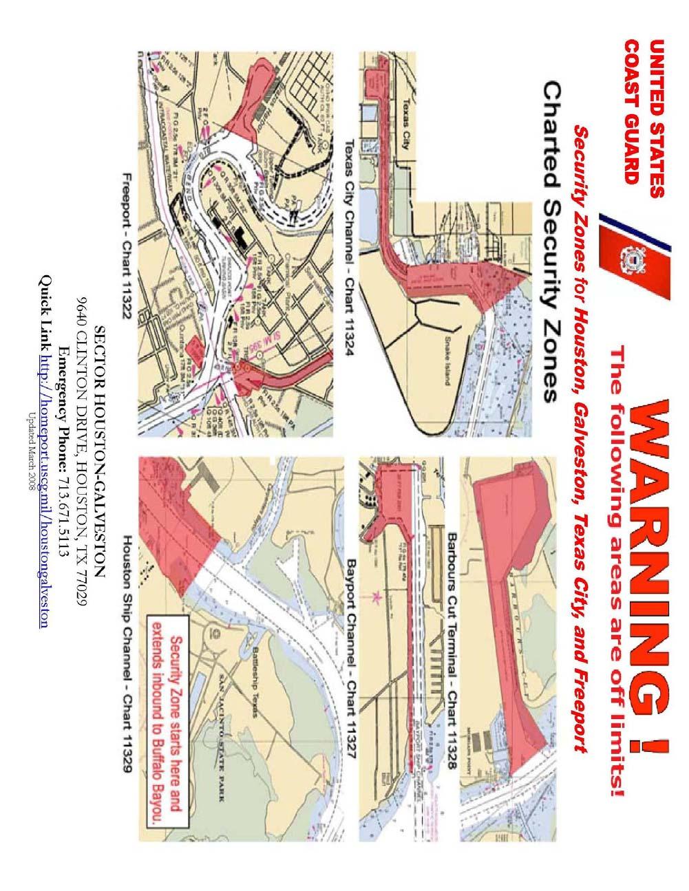
55 E-2
56 Appendix F Railway Bridge Alternate Route Galveston Railway Bridge Alternate Transit Procedure MSIB is available at Sector s portion of the USCG HOMEPORT Web-Site Coast Guard Sector Houston-Galveston, working with its industry partners, has implemented an Alternate Transit Procedure for towboats transiting the Galveston Railroad Bridge. This Alternate Transit Procedure is acceptable to both the Coast Guard and the Railroad. The conditions for use of the Alternate Transit Procedure are listed below: 1. This procedure applies only to westbound tows transiting the Galveston Railroad Bridge. 2. All existing restrictions in place at the bridge remain in place. 3. This procedure is optional and may be implemented at the discretion of the vessel pilot. 4. Tows desiring to use the Alternate Transit Procedure for transiting the railroad bridge must notify VTS Houston-Galveston via either VHF Radio or telephone. This notification may be made on Channel 12 or by calling when checking out of the VTSA at Pelican Cut. When calling the bridge operator for clearance, tows must clearly and specifically state their intention to use the alternate transit procedure. 5. The bridge operator will make a special, highlighted log entry for vessels using the Alternate Transit Procedure (i.e. number of barges, empty or loaded, boat name) in the Galveston Railroad Bridge logbook, so that records of these transits may be periodically reviewed. 6. The Alternate Transit Procedure steps are: a. Upon checking out of the VTSA, provide notification of intent to transit the Galveston Railroad Bridge to both VTS Houston-Galveston and to the operator of the bridge. b. As is usual prior to approaching the Galveston Railroad Bridge, call the bridge operator and post a lookout at the head of the tow. c. Stop the head of the tow and safely land the head of the tow on the east side, downwind dolphin of the Galveston Railroad Bridge. d. Once properly aligned for safe transit, proceed westbound through the railroad bridge. e. If damage is not sustained during the transit, reporting is not required. However, if any damage is sustained, immediately notify the Sector Command Center at In addition, complete and submit Form CG-2692, Report of Marine Casualty or Death. F-1
57 GALVESTON RAILROAD BRIDGE EXISTING TOW RESTRICTIONS 1. Tows made up of all empty barges are limited to 600 feet in length (not including the towing vessel). 2. All tows, loaded or empty, are restricted to a maximum width of 70 feet. 3. Mixed Tows made up of loaded and empty barges are unrestricted on length, provided that at least half the barges are loaded. Mixed tows with a majority of empty barges are treated as an all-empty tow. 4. Tows made up of all loaded barges are unrestricted on length. 5. Tows with operating bow steering units, whether loaded or empty, are unrestricted on length. 6. Westbound, all-empty tows made up of more than one barge must have an assist vessel. F-2
58 Appendix G Oversize Tows Oversized Tow Permits A towboat and/or towboat company must request an oversized tow permit in certain situations as described by 33 CFR Permit requests will be reviewed and processed by the Situation Controller at Sector Houston-Galveston. On waterways of 150 feet or less in width, a tow greater than 1180 feet, including the towing vessel but excluding the hawser length, or greater than one-half the bottom width of the channel or 55 feet, which ever is less, is required to receive special permission to use that waterway from the District Commander. CCGD8INST A delegates this authority to the COTP. There are 3 categories of oversized tows: (1) Tows over 1180 feet on waterways of 150 feet or less in width. (2) Tows in excess of one-half the bottom width of the channel or 55 feet, which can be broken down. (3) Tows in excess of one half the bottom width of the channel or 55 feet, which cannot be broken down. Category (1) and (2) Oversize Tow Permits are routinely granted by watchstanders and the operator will be reminded of the regulatory requirements. Tows in Category (3) require watchstander liaison with the Sector Waterways Management Division Chief and may require more lead time. You do not require a permit for: Maximum Length: Maximum width: 1180 feet (including the towing vessel) 55 feet Tows that have permits issued from other D8 COTP Zones Tows that will transit only in channels greater than 150 wide G-1
59 Appendix H VTSA Distance Tables Distances are in nautical miles. LB LB LB LT CARB LT LT LT BAYP 1C/2C 11/12 PIB GICW 25/26 31/32 TB 45/46 53/54 69/70 TB LB 1C/2C LB 11& PIB GICW LB 25& LT 31& OILTT LT 45& LT 53& LT 69& BAYP TB LT 75& MORG PT EXXON LYNCH CARP SHELL GREEN HUNT TB LYON TB SSB HOU TB H-1
60 LT MORG HUNT LYON HOU 75/76 PT EXXON LYNCH CARP SHELL GREEN TB TB SSB TB LB 1C/2C LB 11& PIB GICW LB 25& LT 31& OILTT LT 45& LT 53& LT 69& BAYP TB LT 75& MORG PT EXXON LYNCH CARP SHELL GREEN HUNT TB LYON TB SSB HOU TB H-2

61 Appendix I Reporting Points I-1
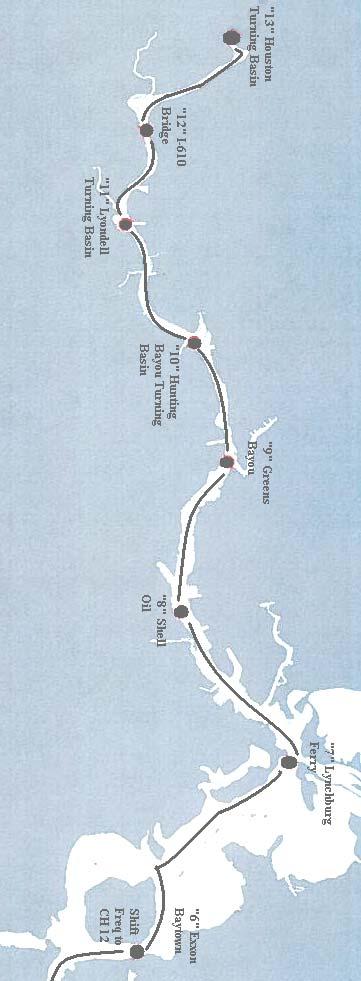
62 I-2
63 Appendix J Working Frequencies Working Frequencies along the Houston Ship Channel This informal list of frequencies is intended only as a useful reference and offers no official endorsement of frequency usage. VHF Use 05A VTS Houston/Galveston Sailing Plans 09 Kirby Fleeting Area Old River 10 Channel Shipyard San Jacinto River Tow Traffic 11 VTS Houston/Galveston Sector III (Above Exxon Baytown) 12 VTS Houston/Galveston Sectors I/II (Below Exxon Baytown) 13 Bridge-to-Bridge Radiotelephone 14 Port Operations and Ship-to-Tug; Pilot Boats 16 International Distress and Calling 19 Exxon-Mobil Docks - Baytown 21A USCG Sector Houston-Galveston Working 22A Government/non-Government Liaison 73 Galveston-Texas City Pilots Working 74 Houston Pilots Working 81 US Coast Guard Working 83 US Coast Guard Working J-1
64 Appendix K Useful Internet Links VTS Houston/Galveston USCG Homeport Missions NOAA Physical Oceanographic Real-Time System NOAA NWS Houston-Galveston Area Weather NOAA NWS National Hurricane Center Houston Pilots Galveston-Texas City Pilots HOGANSAC Navigating the Houston Ship Channel Brochure is located in the Best Practices/Work Products Section K-1
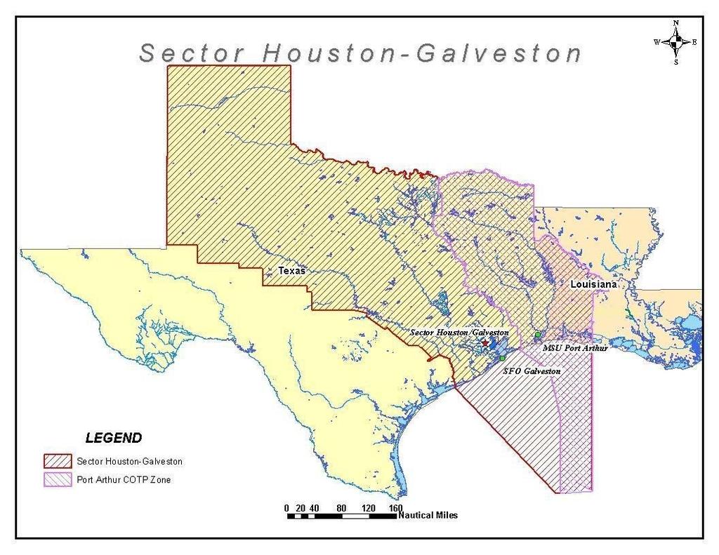
65
VESSEL TRAFFIC SERVICE HOUSTON/GALVESTON
 VESSEL TRAFFIC SERVICE HOUSTON/GALVESTON USER'S MANUAL Revised August 2017 VMRS Users (Full Participation): USER GROUPS These vessels must monitor the designated VTS VHF-FM frequency, make reports to the
Delaware River Vessel Reporting System Mariners Advisory Committee For
 Delaware River Vessel Reporting System Mariners Advisory Committee For the Bay and River Delaware The Mariner's Advisory Committee is comprised of Master Mariners, River Pilots, and concerns itself with
1972 Collision Regulations definition of a vessel. Note: Vessel length is measured from end to end over the deck, excluding sheer.
 User Definitions VMRS (Vessel Movement Reporting System) Users: Every power-driven vessel of 40 meters (approximately 131 feet) or more in length, while navigating; Every commercial vessel engaged in towing
VTS Prince William Sound User s Manual May 2017 Edition. U.S. Coast Guard. Vessel Traffic Service Prince William Sound.
 U.S. Coast Guard Vessel Traffic Service Prince William Sound User s Manual Twelfth Edition May 2017 1 Notes 2 Purpose of this Manual: With the implementation of Vessel Traffic Management regulations contained
COOPERATIVE VESSEL TRAFFIC SERVICE (CVTS) TAMPA BAY, FLORIDA
 TAMPA BAY, FLORIDA") COOPERATIVE VESSEL TRAFFIC SERVICE (CVTS) TAMPA BAY, FLORIDA USERS MANUAL Oct 2010 1 st Edition Serving the Port of Tampa, Port Manatee, Port of Saint Petersburg, and the Waterways of Tampa Bay 1 Table
COOPERATIVE VESSEL TRAFFIC SERVICE (CVTS) TAMPA BAY, FLORIDA USERS MANUAL Oct 2010 1 st Edition Serving the Port of Tampa, Port Manatee, Port of Saint Petersburg, and the Waterways of Tampa Bay 1 Table
PILOTAGE DIRECTIONS REVIEWED DECEMBER 2016
 PILOTAGE DIRECTIONS REVIEWED DECEMBER 2016 REVISION LIST Revision No. Date Details Approved by: Original All sections 12 Dec 2013 First edition of C W Brand v1.0 Pilotage Directions Revision 2 all sections
LOWER MISSISSIPPI RIVER PRE-ENTRY INFORMATION
 LOWER MISSISSIPPI RIVER PRE-ENTRY INFORMATION Notice of Arrivals Prior to Arrival at any U.S. port, the vessel master should ensure a complete and accurate Notice of Arrival has been submitted to National
WORK-REST REQUIREMENTS FOR PILOTS
 AN ORDER OF THE BOARD OF PILOT COMMISSIONERS FOR THE PORT OF CORPUS CHRISTI AUTHORITY REGARDING WORK-REST REQUIREMENTS FOR PILOTS AND COMBINED BEAM RESTRICTION Whereas, the current Rules and Regulations
RESOLUTION MSC.161(78) (adopted on 17 May 2004) AMENDMENTS TO THE EXISTING MANDATORY SHIP REPORTING SYSTEM "THE TORRES STRAIT AND INNER ROUTE OF THE
 (adopted on 17 May 2004) AMENDMENTS TO THE EXISTING MANDATORY SHIP REPORTING SYSTEM THE TORRES STRAIT AND INNER ROUTE OF THE") MSC 78/26/Add.2 RESOLUTION MSC.161(78) REPORTING SYSTEM THE TORRES STRAIT AND INNER ROUTE OF THE GREAT BARRIER REEF THE MARITIME SAFETY COMMITTEE, RECALLING Article 28(b) of the Convention on the International
MSC 78/26/Add.2 RESOLUTION MSC.161(78) REPORTING SYSTEM THE TORRES STRAIT AND INNER ROUTE OF THE GREAT BARRIER REEF THE MARITIME SAFETY COMMITTEE, RECALLING Article 28(b) of the Convention on the International
VESSEL TRAFFIC SERVICE NEW YORK USER'S MANUAL
 USER S MANUAL Revised March 2016 VESSEL TRAFFIC SERVICE NEW YORK USER'S MANUAL Revised March 2016 TABLE OF CONTENTS SECTION Page Table of Contents 1 Introduction 2 Vessel Traffic Management (33 CFR 161)
IMO RESOLUTION A.960(23) Adopted 5 December 2003 (Agenda item 17)
 Adopted 5 December 2003 (Agenda item 17)") INTERNATIONAL MARITIME ORGANIZATION E IMO ASSEMBLY 23rd session Agenda item 17 A 23/Res.960 5 March 2004 Original: ENGLISH RESOLUTION A.960(23) Adopted 5 December 2003 (Agenda item 17) RECOMMENDATIONS
INTERNATIONAL MARITIME ORGANIZATION E IMO ASSEMBLY 23rd session Agenda item 17 A 23/Res.960 5 March 2004 Original: ENGLISH RESOLUTION A.960(23) Adopted 5 December 2003 (Agenda item 17) RECOMMENDATIONS
COAST GUARD ADVISORY NOTICE (CGAN ) To: Distribution Date: September 1, 2017
 To: Distribution Date: September 1, 2017") Commander United States Coast Guard Sector New York 212 Coast Guard Drive Staten Island, NY 10305 Staff Symbol: (spw) Phone: (718) 354-2353 Fax: (718) 354-4190 COAST GUARD ADVISORY NOTICE (CGAN 2017-016)
Commander United States Coast Guard Sector New York 212 Coast Guard Drive Staten Island, NY 10305 Staff Symbol: (spw) Phone: (718) 354-2353 Fax: (718) 354-4190 COAST GUARD ADVISORY NOTICE (CGAN 2017-016)
Vessel Traffic Service Lower Mississippi River
 Vessel Traffic Service Lower Mississippi River User Manual Third Edition 2013 Available for self printing at: http://homeport.uscg.mil TABLE OF CONTENTS INTRODUCTION... 1 GENERAL INFORMATION... 1 DEFINITIONS...
GENERAL LIMITATIONS AND RESTRICTIONS. LNGC Temporary Exemption (Effective August 21, 2018)
") RULES AND REGULATIONS GOVERNING PILOTS AND PILOTAGE ON THE CORPUS CHRISTI SHIP CHANNEL EFFECTIVE AUGUST 1, 2013 AMENDED EFFECTIVE MAY 13, 2014 AMENDED EFFECTIVE OCTOBER 1, 2014 AMENDED EFFECTIVE JANUARY
RULES AND REGULATIONS GOVERNING PILOTS AND PILOTAGE ON THE CORPUS CHRISTI SHIP CHANNEL EFFECTIVE AUGUST 1, 2013 AMENDED EFFECTIVE MAY 13, 2014 AMENDED EFFECTIVE OCTOBER 1, 2014 AMENDED EFFECTIVE JANUARY
APC Operating Procedures Oil Tankers
 APC Operating Procedures Oil Tankers August 2013 The APC Operating Procedures were developed to aid the Master and Operator of oil tankers in ensuring all aspects of the APC are complied with when transiting
AK-APC-NTV Operating Procedures for Cargo and Passenger Non Tank Vessels Transiting and Operating in Alaska Waters December 26, 2015
 AK-APC-NTV Operating Procedures for Cargo and Passenger Non Tank Vessels Transiting and Operating in Alaska Waters December 26, 2015 The Alternative Planning Criteria (APC) Operating Procedures were developed
properly applied assessment in the use.1 landmarks.1 approved in-service of ECDIS is not experience The primary method of fixing required for those
 STCW Code Table A-II/3 Specification of minimum standard of for officers in charge of a navigational watch and for masters on ships of less than 500 gross tonnage engaged on near-coastal voyages Ref: https://www.edumaritime.net/stcw-code
The LA/LB Harbors handle more than 5,500 commercial vessel arrivals per year (excluding local coastwise and Catalina Island traffic).
.") X. SMALL CRAFT For the purpose of the Los Angeles and Long Beach Harbor Safety Plan, pleasure vessels, commercial fishing vessels and sportfishing boats are designated as small craft. A. BACKGROUND: The
X. SMALL CRAFT For the purpose of the Los Angeles and Long Beach Harbor Safety Plan, pleasure vessels, commercial fishing vessels and sportfishing boats are designated as small craft. A. BACKGROUND: The
GUIDELINES FOR NAVIGATION UNDER THE CONFEDERATION BRIDGE
 (12/2009) GUIDELINES FOR NAVIGATION UNDER THE CONFEDERATION BRIDGE REVISION 1 DECEMBER 2009 Responsible Authority The Regional Director Marine Safety Atlantic Region is responsible for this document, including
Towed Barge Standard of Care
 Lower Columbia Region Harbor Safety Committee Towed Barge Standard of Care Page 1 of 6 A. 1. Purpose The Columbia River is intended to eliminate conflicts between towing vessels conducting astern towing
GENERAL LIMITATIONS AND RESTRICTIONS. Draft Restrictions
 RULES AND REGULATIONS GOVERNING PILOTS AND PILOTAGE ON THE CORPUS CHRISTI SHIP CHANNEL EFFECTIVE AUGUST 1, 2013 AMENDED EFFECTIVE MAY 13, 2014 AMENDED EFFECTIVE OCTOBER 1, 2014 I GENERAL The Rules and
LOCAL NOTICE TO MARINERS
 USCG Notice to Mariners 3/7/18 (View full Notice here) LNM 10/18 Coast Guard District 1: U.S. Department of Homeland Security United States Coast Guard LOCAL NOTICE TO MARINERS COASTAL WATERS FROM EASTPORT,
Pilotage Directions 2017
 Pilotage Directions 2017 1. Commencement These Pilotage Directions shall come into force on 31 st August 2017 on which date the existing Pilotage Directions are revoked. 2. Short Title These Pilotage Directions
NavRule Practice Exam, 70 Series Practice April 24, Labeled F (I received a reply from the testing service that all these answers were
 1. INTERNATIONAL & INLAND An all-round flashing yellow light may be exhibited by a(n)? a. vessel laying cable b. vessel towing a submerged object c. vessel not under command d. air cushion vessel 2. INTERNATIONAL
National Maritime Center
 National Maritime Center Providing Credentials to Mariners Q301 Rules of the Road-Inland (Sample Examination) Page 1 of 19 Choose the best answer to the following Multiple Choice Questions. NO reference
VESSEL TRAFFIC SERVICE NEW YORK USER'S MANUAL Revised September 2018
 USER S MANUAL Revised September 2018 VESSEL TRAFFIC SERVICE NEW YORK USER'S MANUAL Revised September 2018 TABLE OF CONTENTS SECTION Page Table of Contents 1 Introduction 2 Contact Information 4 Vessel
Subj: CHANGE 2 to USER MANUAL FOR VESSEL MOVEMENT REPORTING SYSTEM (VMRS) BUZZARDS BAY
 BUZZARDS BAY") Commander U.S. Coast Guard Sector Southeastern New England Prevention Department 20 Risho Ave East Providence, RI 02914-1208 Staff Symbol: Phone: 401-435-2351 Fax: 401-435-2399 Email: Edward.G.LeBlanc@uscg.mil
Commander U.S. Coast Guard Sector Southeastern New England Prevention Department 20 Risho Ave East Providence, RI 02914-1208 Staff Symbol: Phone: 401-435-2351 Fax: 401-435-2399 Email: Edward.G.LeBlanc@uscg.mil
Rules Practice Exam 11
 1 BOTH INTERNATIONAL & INLAND While underway in fog, you hear a vessel sound one prolonged blast followed by two short blasts on the whistle. What does this signal indicate? A. A vessel towing B. A vessel
August April 18,2008 First Revision
 August 15 2011 Slide 01 April 18,2008 First Revision August 15, 2011 Text converted to Tables for ease of formatting instructor guide. Slide 23 Sound Signals Corrected Danger Signal 5 or More Short Blasts
Severe Weather Planning Information. Maritime Stakeholders
 Severe Weather Planning Information for the Maritime Stakeholders Port Arthur Captain of the Port Zone Sabine-Neches Waterway, Calcasieu Waterway and Gulf Intracoastal Waterway Revised: May 2018 INTRODUCTION
International regulations and guidelines for maritime spatial planning related to safe distances to multiple offshore structures (e.g.
 International regulations and guidelines for maritime spatial planning related to safe distances to multiple offshore structures (e.g. wind farms) Introduction This is a summary of the most important international
U.S. Department Of Homeland Security
 U.S. Department Of Homeland Security CHANGE NUMBER DATE OF CHANGE RECORD OF CHANGES DATE ENTERED BY WHOM ENTERED i CONTENTS INTRODUCTION... iv LEGAL CITATIONS... vi CONVERSION TABLE... vii NAVIGATION RULES...
Rules Practice Exam 9
 1 BOTH INTERNATIONAL & INLAND If your vessel is underway in fog and you hear one prolonged and three short blasts, this is a. A. vessel not under command B. sailing vessel C. vessel being towed (manned)
Vessel Traffic Service Berwick Bay
 Vessel Traffic Service Berwick Bay User Manual Edition 2012 www.uscg.mil Welcome to VTS Berwick Bay and thank you for taking the time to read our User Manual. It contains information that will help you
OSAKA MARTIS USER MANUAL TABLE OF CONTENTS
 OSAKA MARTIS USER MANUAL TABLE OF CONTENTS Ⅰ Ⅱ Ⅲ INTRODUCTION OPERATIONAL CONCEPT OF "Osaka MARTIS" IMPORTANT NAVIGATIONAL RULES Ⅳ COMMUNICATION 1 VHF Channels 2 Language Ⅴ PRE-ENTRY REPORT AND POSITION
Important Information for Yachts & Agents
 Important Information for Yachts & Agents 1. The Yacht Services of Alaska agent is your contact for all requests for pilotage and pilot boat services. Refer all communication regarding pilotage to them.
Enhanced Discussion of Requirements for Commercial Fishing Vessels
 Update on U.S. Commercial Fishing Industry Vessel Requirements Based On Section 604 of the Coast Guard Authorization Act of 2010 (Public Law 111-281) And Section 305 of the Coast Guard and Maritime Transportation
PILOTAGE INFORMATION
 PILOTAGE INFORMATION Revised A PILOTAGE DIRECTIONS The Gloucester Harbour Trustees is the Competent Harbour Authority for the Gloucester Harbour under the Pilotage Act 1987 and responsible for the provision
Towing Officers' Assessment Record: Near Coastal/Oceans
 Towing Officers' Assessment Record: Near Coastal/Oceans NAME: LICENSE NO.: Task No. Considered Proficient Common Element Task or Duty DE's Initials Date A. Vessel Familiarization A.1. X Locate and demonstrate
Rules Practice Exam 7
 1 INTERNATIONAL ONLY The light which may be used with a vessel's whistle is to be. A. used when the whistle is broken B. used prior to sounding the whistle C. used only at night D. a white light 2 INTERNATIONAL
TOWING OFFICER ASSESSMENT RECORD
 TOWING OFFICER ASSESSMENT RECORD NEAR COASTAL / OCEANS SIGNATED EXAMINER INFORMATION All Designated Examiners (s) signing off successful completion of practical assessments should provide the information
WAK-APC-T Operating Procedures for Oil Tankers Transiting or Operating in Western Alaska Waters
 WAK-APC-T Operating Procedures for Oil Tankers Transiting or Operating in Western Alaska Waters RECORD OF CHANGE WAK-APC-T Operating Procedures for Oil Tankers Transiting or Operating In Western Alaska
Convention on the International Regulations for Preventing Collisions at Sea, 1972 (COLREGs) EXPLANATORY NOTES
 EXPLANATORY NOTES") Convention on the International Regulations for Preventing Collisions at Sea, 1972 (COLREGs) EXPLANATORY NOTES Adoption: 20 October 1972 Entry into force: 15 July 1977 Introduction Amendment procedure
Convention on the International Regulations for Preventing Collisions at Sea, 1972 (COLREGs) EXPLANATORY NOTES Adoption: 20 October 1972 Entry into force: 15 July 1977 Introduction Amendment procedure
Rules Practice Exam 14
 1 BOTH INTERNATIONAL & INLAND Additional light signals are provided in the Annexes to the Rules for vessels. A. engaged in fishing B. not under command C. engaged in towing D. under sail 2 BOTH INTERNATIONAL
National Maritime Center
 National Maritime Center Providing Credentials to Mariners U.S.C.G. Merchant Marine Exam (Sample Examination) Page 1 of 22 U.S.C.G. Merchant Marine Exam: Illustrations: 10 Choose the best answer to the
KANMON KAIKYO VESSEL TRAFFIC SERVICE CENTER KANMON MARTIS USER MANUAL TABLE OF CONTENTS Ⅱ OPERATIONAL CONCEPT OF THE "KANMON MARTIS" 1
 KANMON KAIKYO VESSEL TRAFFIC SERVICE CENTER KANMON MARTIS USER MANUAL TABLE OF CONTENTS Ⅰ INTRODUCTION 1 Ⅱ OPERATIONAL CONCEPT OF THE "KANMON MARTIS" 1 Ⅲ IMPORTANT NAVIGATIONAL RULES 2 Ⅳ COMMUNICATION
RECORD OF CHANGES DATE EFFECTIVE
 RECORD OF CHANGES CHANGE NUMBER DATE OF CHANGE DATE EFFECTIVE BY WHOM ENTERED CONTENTS INTRODUCTION... i LEGAL CITATIONS... iii CONVERSION TABLE... iv NAVIGATION RULES AND REGULATIONS INTERNATIONAL AND
MARINER S GUIDE TO THE FORTH
 MARINER S GUIDE TO THE FORTH INTRODUCTION 1. The Statutory Harbour Authority s area of jurisdiction on the River and Firth of Forth ( The Forth ) extends from approximately one mile west of the Isle of
Commandant United States Coast Guard NAVIGATION AND VESSEL INSPECTION CIRCULAR NO. 2-97, CHANGE 1
 Commandant United States Coast Guard 200 Second Street, S.W. Washington, DC 20593-000 Staff Symbol: G-MOC Phone: 202-267-464 A DISTRIBUTION SDL No. 34 a b c d e f g h I j k l m n o p q r s t u v w x y
Incident Management Guidelines for Initial Actions and Communications
 Lower Columbia Region Harbor Safety Committee Incident Management Guidelines for Initial Actions and Communications Page 1 of 16 Table of Contents A. INCIDENT MANAGEMENT GUIDELINES... 3 1. PURPOSE... 3
ASSOCIATED BRITISH PORTS - LOWESTOFT
 ASSOCIATED BRITISH PORTS - LOWESTOFT PILOTAGE DIRECTION (With Amendments To 01/02/2012) 1. AUTHORISATION Pilotage Act 1987. Associated British Ports Lowestoft (Pilotage) Harbour Revision Order 1988. 2.
LAPWARE, LLC. Since 2002
 CORRECTED THROUGH 23 NOV 2011 LAPWARE, LLC www.lapware.org Since 2002 www.lapwareengine.org Since 2011 CHANGE NUMBER DATE OF CHANGE RECORD OF CHANGES DATE ENTERED BY WHOM ENTERED 001 25 MAR 99 ONGOING
Enclosure (5) to NVIC 03-16
 to NVIC 03-16") TOWING OFFICER ASSESSMENT RECORD LIMITED LOCAL AREA LOCAL LIMITED AREA (LLA) TOAR INSTRUCTIONS FOR USE The following Towing Officer Assessment Record (TOAR) is intended as a model for endorsements as Limited
TOWING OFFICER ASSESSMENT RECORD LIMITED LOCAL AREA LOCAL LIMITED AREA (LLA) TOAR INSTRUCTIONS FOR USE The following Towing Officer Assessment Record (TOAR) is intended as a model for endorsements as Limited
Towing Officers' Assessment Record: Western Rivers
 Towing Officers' Assessment Record: Western Rivers NAME: LICENSE NO.: Task No. Considered Proficient Common Element Task or Duty DE's Initials Date A. Vessel Familiarization A.1. X Locate and demonstrate
National Maritime Center
 National Maritime Center Providing Credentials to Mariners (Sample Examination) Page 1 of 19 Choose the best answer to the following multiple choice questions. NO reference materials are authorized for
SAILING INSTRUCTIONS. Port of Los Angeles Harbor Cup Cal Maritime Invitational Intercollegiate Regatta March 9 th -11 th, RULES
 SAILING INSTRUCTIONS Port of Los Angeles Harbor Cup Cal Maritime Invitational Intercollegiate Regatta March 9 th -11 th, 2018 1 RULES 1.1 The regatta will be governed by the ICSA Procedural Rules (PR),
COMDTINST M D MAR
 Commandant United States Coast Guard 2100 Second St., SW United States Coast Guard Washington, DC 20593-0001 Staff Symbol: G-MW Phone: 202-267-0407 Fax: 202-267-4826 COMDTINST M16672.2D MAR 25 1999 COMMANDANT
DUBLIN PORT COMPANY PILOTAGE BYE-LAWS. 1st July Dublin Port Company Pilotage Bye-Laws, 1 st July 2018 Page 1
 DUBLIN PORT COMPANY PILOTAGE BYE-LAWS 1st July 2018 Dublin Port Company Pilotage Bye-Laws, 1 st July 2018 Page 1 Contents PILOTAGE BYE-LAWS... 3 1) Interpretation... 3 2) Compulsory Pilotage and Exempted
Rules Practice Exam 12
 1 INLAND ONLY You are on vessel "A", and vessel "B" desires to overtake you on your starboard side as shown. After the vessels have exchanged one blast signals, you should. Diagram 31 A. alter course to
ROUTEING MEASURES OTHER THAN TRAFFIC SEPARATION SCHEMES
 E 4 ALBERT EMBANKMENT LONDON SE1 7SR Telephone: +44 (0)20 7735 7611 Fax: +44 (0)20 7587 3210 SN.1/Circ.317 4 December 2012 ROUTEING MEASURES OTHER THAN TRAFFIC SEPARATION SCHEMES 1 The Maritime Safety
Rules of the Road. United States Power Squadrons USPS University
 Rules of the Road United States Power Squadrons USPS University Seminar and contents copyrighted by USPS 2008 Per Inland Rules: Boats 12 m or greater must carry a copy of these rules Seminar Reference
New Requirements for Commercial Fishing Industry Vessels Section 604 Coast Guard Authorization Act of 2010 (Public Law )
") New Requirements for Commercial Fishing Industry Vessels Section 604 Coast Guard Authorization Act of 2010 (Public Law 111-281) On October 15, 2010, the President signed the law that included provisions
New Requirements for Commercial Fishing Industry Vessels Section 604 Coast Guard Authorization Act of 2010 (Public Law 111-281) On October 15, 2010, the President signed the law that included provisions
Automatic Identification System (AIS) Class B - coding for non-solas vessels.
 Class B - coding for non-solas vessels.") MARINE INFORMATION NOTE MIN 321 (M+F) Automatic Identification System (AIS) Class B - coding for non-solas vessels. Notice to all Shipowners, Masters, Small Craft Vessel Operators, Leisure Vessel Users,
MARINE INFORMATION NOTE MIN 321 (M+F) Automatic Identification System (AIS) Class B - coding for non-solas vessels. Notice to all Shipowners, Masters, Small Craft Vessel Operators, Leisure Vessel Users,
iii) Satisfactory completion of approved training in the following:
 Satisfactory completion of approved training in the following:") Enclosure (1) to NVIC 13-14 DISCUSSION OF QUALIFICATION REQUIREMENTS FOR MASTER AND OFFICER IN CHARGE OF A NAVIGATIONAL WATCH ON VESSELS OF LESS THAN 500 GT LIMITED TO NEAR-COASTAL WATERS 1. GENERAL. This
Enclosure (1) to NVIC 13-14 DISCUSSION OF QUALIFICATION REQUIREMENTS FOR MASTER AND OFFICER IN CHARGE OF A NAVIGATIONAL WATCH ON VESSELS OF LESS THAN 500 GT LIMITED TO NEAR-COASTAL WATERS 1. GENERAL. This
UNITED NEW YORK SANDY HOOK PILOTS BENEVOLENT ASSOCIATION AND UNITED NEW JERSEY SANDY HOOK PILOTS BENEVOLENT ASSOCIATION
 UNITED NEW YORK SANDY HOOK PILOTS BENEVOLENT ASSOCIATION AND UNITED NEW JERSEY SANDY HOOK PILOTS BENEVOLENT ASSOCIATION TO: All Shipping Agents and Interested Parties January 19, 2017 SUBJECT: Anchorage
Whitstable Harbour Pilotage Information
 Whitstable Harbour Pilotage Information (Issue 4 October 2014) Contents 1. Pilotage Services 2. Pilotage Directions 3. Pilotage Directions - Supporting Information 4. Passage Plan 5. Pilotage Recruitment
SOLAS requirements for nonpassenger ships 300 or above but less than 500 gross tonnage
 SOLAS requirements for nonpassenger ships 300 or above but less than 500 gross tonnage Guidance for owners, masters and surveyors for ships undertaking international voyages SOLAS requirements applied
SS&S Chapter 8 Instructor Guide
 SS&S Chapter 8 Instructor Guide The Rules of the Nautical Road The PowerPoints (PPT) slides for this SS&S chapter were copied from the BS&S-13 th Ed PPT because they are identical. Only the chapter numbers
LOCAL NOTICE TO MARINERS
 USCG Notice to Mariners 3/26/15 (View full Notice here) LNM 12/15 Coast Guard District 1 : U.S. Department of Homeland Security United States Coast Guard LOCAL NOTICE TO MARINERS COASTAL WATERS FROM EASTPORT,
Adverse Weather and Management of Vessel Traffic
 Adverse Weather and Management of Vessel Traffic VTS PRINCE WILLIAM SOUND LT Allie Ferko, VTS Director 01 May 2014 Vessel Movement Reporting System 33CFR161.16 VMRS Users are defined as: Power driven vessels
Marine Safety Information Bulletin COAST GUARD GUIDANCE FOR DEAD SHIP MOVEMENT IN SECTOR HONOLULU CAPTAIN OF THE PORT ZONE.
 Marine Safety Information Bulletin 16-002 U.S. DEPARTMENT OF HOMELAND SECURITY U. S. Coast Guard Sector Honolulu Sand Island Parkway Honolulu, Hawaii 96819 (808) 842-2600 COAST GUARD GUIDANCE FOR DEAD
 ON SHIPS OF 200 GRT/500 GT OR MORE Assessment Sheets Enclosure (1) to CG-543 Policy Letter 11-07 ASSESSMENT NO. OICNW-1-1A COMPETENCE: Plan and conduct a passage and determine position KNOWLEDGE, UNDERSTANDING
ocr o12011
 Commandant 2100 2na St. S.W Stop 7581 Homeland U.S. Departmento~ Security United States Coast Guard Washington, DC 20593-7581 Staff Symbol: CG-543 United States Phone: (202) 372-1250 Coast Guard Fax: (202)
GENERAL GUIDELINES FOR VESSELS TRANSITING RESTRICTED WATERWAYS OR PORTS
 GENERAL GUIDELINES FOR VESSELS TRANSITING RESTRICTED WATERWAYS OR PORTS Revised: March 5, 2018 TABLE OF CONTENTS GENERAL DEFINITIONS... 2 VESSEL SPACING... 3 HORIZONTAL CLEARANCE... 3 UNDER-KEEL CLEARANCE
RESOLUTION A.485(XII) adopted on 19 November 1981 TRAINING, QUALIFICATIONS AND OPERATIONAL PROCEDURES FOR MARITIME PILOTS OTHER THAN DEEP-SEA PILOTS
 adopted on 19 November 1981 TRAINING, QUALIFICATIONS AND OPERATIONAL PROCEDURES FOR MARITIME PILOTS OTHER THAN DEEP-SEA PILOTS") INTER-GOVERNMENTAL MARITIME CONSULTATIVE ORGANIZATION ASSEMBLY - 12th session Agenda item lo(b) RESOLUTION A.485(XII) adopted on 19 November 1981 IMCO RESOLUTION A.485(XII) adopted on 19 November 1981
INTER-GOVERNMENTAL MARITIME CONSULTATIVE ORGANIZATION ASSEMBLY - 12th session Agenda item lo(b) RESOLUTION A.485(XII) adopted on 19 November 1981 IMCO RESOLUTION A.485(XII) adopted on 19 November 1981
THE SYLLABUS FOR WRITTEN EXAMINATION PILOT'S FOURTH CLASS LICENCE (TEES AND HARTLEPOOL) AND
 AND") PD TEESPORT CONSERVANCY DIVISION HARBOUR MASTER'S OFFICE THE SYLLABUS FOR WRITTEN EXAMINATION IN RESPECT OF A PILOT'S FOURTH CLASS LICENCE (TEES AND HARTLEPOOL) AND PILOTAGE EXEMPTION CERTIFICATE (Issued
PD TEESPORT CONSERVANCY DIVISION HARBOUR MASTER'S OFFICE THE SYLLABUS FOR WRITTEN EXAMINATION IN RESPECT OF A PILOT'S FOURTH CLASS LICENCE (TEES AND HARTLEPOOL) AND PILOTAGE EXEMPTION CERTIFICATE (Issued
You must stop your. pass with caution on the port side of vessel "B" The vessel moving upstream against the current
 BK NUM ANS QUESTION ANSWER A ANSWER B ANSWER C ANSWER D ILLUST 1 1 C 1 2 B INLAND ONLY You are navigating in a narrow channel and must remain in the channel for safe operation. Another vessel is crossing
Uncontrolled document if printed.
 APPENDIX 3 APPRENTICE PILOT S TRAINING SYLLABUS Issue Date: 16 th March, 2010 Date of Revision: 22nd May, 2013 Revision #2 i THE PURPOSE OF THIS SYLLABUS The purpose of this training syllabus is to ensure
1. PURPOSE. This instruction forwards International and Inland Navigation Rules and Regulations for use by Coast Guard personnel.
 U.S. Department of Transportation United States Coast Guard Commandant United States Coast Guard Mailing Address: 2100 2nd Street, S.W. Washington, DC 0593-001 Phone: (202) 267-0352 COMMANDANT INSTRUCTION
Table of Contents. Introduction... ii. Section 1 Vessel Operator Quick Reference Guide. 1-1
 i Table of Contents Introduction... ii Section 1 Vessel Operator Quick Reference Guide. 1-1 Section 2 - Title 33: Navigation and Navigable waters PART 161 VESSEL TRAFFIC MANAGEMENT. 2-1 Subpart A Vessel
National Standard for Commercial Vessels
 National Standard for Commercial Vessels Part E Operations Published 17 May 2013 Endorsed by the Standing Council on Transport and Infrastructure 10 May 2013 Commonwealth of Australia This work is copyright.
References: Manual Chapt. 9 ISO 9001 par.7 ISO par. 4 ISM Code par. 7; 8
 SQEMS OPERATING PROCEDURE OP-SAF-03 1 of 5 References: Manual Chapt. 9 ISO 9001 par.7 ISO 14001 par. 4 ISM Code par. 7; 8 1. SCOPE This Procedure establishes criteria for the control and management of
Vessel Traffic in the Salish Sea Mitigating Risk... Captain Joe Raymond Coast Sector Puget Sound
 Vessel Traffic in the Salish Sea Mitigating Risk.... Captain Joe Raymond Coast Sector Puget Sound Overview Prevention Waterways Management Oil Spill Data Mitigating Risks Sector Puget Sound AOR Blan k
SECTION THREE PILOTAGE DEFINITIONS
 SECTION THREE PILOTAGE First Revised Page... 30 Original Page... 30 DEFINITIONS (a) Pilotage is the charge, calculated in accordance with the pilotage rates named in this Tariff, assessed against a vessel,
MAC Transit Advisories as of April 30, 2018
 MAC Transit Advisories as of April 30, 2018 The Mariners Advisory Committee for the Bay and River Delaware was established in October 1964. Its members and associate members are mainly comprised of master
IMO ROUTEING OF SHIPS, SHIP REPORTING AND RELATED MATTERS
 INTERNATIONAL MARITIME ORGANIZATION E IMO SUB-COMMITTEE ON SAFETY OF NAVIGATION 52nd session Agenda item 3 NAV 52/3/9 13 April 2006 Original: ENGLISH ROUTEING OF SHIPS, SHIP REPORTING AND RELATED MATTERS
U.S. Coast Guard Sector Mobile
 U.S. Coast Guard Sector Mobile Maritime Severe Weather Contingency Port Plan A Guide to Port Planning and Preparation X-2-1 TABLE OF CONTENTS INTRODUCTION Background 1 Authority 1 Applicability and Purpose
NAVAL TERMS. in the direction of the stern (rear) of a ship means order understood and I will follow
 of a ship means order understood and I will follow") NAVAL TERMS Naval Term Translation aft aye aye boatswain s stores bulkhead colours coxswain deck duty watch fore galley gangway gash-can heads kye liberty boat out pipes pipe pipe down port scran locker
NAVAL TERMS Naval Term Translation aft aye aye boatswain s stores bulkhead colours coxswain deck duty watch fore galley gangway gash-can heads kye liberty boat out pipes pipe pipe down port scran locker
Harbourmaster s Office Operation of Superyacht in the Auckland Region Navigation Safety Operating Requirements
 Harbourmaster s Office Operation of Superyacht in the Auckland Region Navigation Safety Operating Requirements Foreword Maritime Rule 90 requires that every vessel of 500 Gross tonnage or greater carries
Incident Report. Close Quarters Pegasus II & Distraction. 26 April 2006 Class B
 Incident Report Close Quarters Pegasus II & Distraction 26 April 2006 Class B NARRATIVE Pegasus II (See Photograph 1 Pegasus II) is a 15.46 metre commercial fishing vessel with a gross tonnage of 40. She
HELSINKI COMMISSION HELCOM SAFE NAV 4/2014 Group of Experts on Safety of Navigation Fourth Meeting Helsinki, Finland, 4 February 2014
 HELSINKI COMMISSION HELCOM SAFE NAV 4/2014 Group of Experts on Safety of Navigation Fourth Meeting Helsinki, Finland, 4 February 2014 Agenda Item 3 Accidents and ship traffic in the Baltic Sea Document
How To Enter Kushiro Port and Things To Be Aware of When Entering
 How To Enter Kushiro Port and Things To Be Aware of When Entering 1.How to enter Kushiro Port (1)How to enter the East Area When entering the port from Nemuro, navigate while maintaining a safe distance
Rules Practice Exam 5
 1 BOTH INTERNATIONAL & INLAND Vessel "A" (towing) and vessel "B" are meeting as shown. In this situation, which statement is TRUE? Diagram 12 A. Both vessels should alter course to starboard and pass port
Towing Officers' Assessment Record: Great Lakes/Inland
 Towing Officers' Assessment Record: Great Lakes/Inland NAME: LICENSE NO.: Task No. Considered Proficient Common Element Task or Duty DE's Initials Date A. Vessel Familiarization A.1. Locate and demonstrate
TECHNICAL CIRCULAR. Circular No: S-P15 /13 Revision: 0 Page: 1 of 9 Date:
 Circular No: S-P15 /13 Revision: 0 Page: 1 of 9 Date:25.04.2013 Related Requirement: UR N1 Subject: One man bridge operated (OMBO) ships Note: For ships contracted for construction as defined in IACS PR29
NavRule Practice Exam, 70 Series Practice April 18, Labeled C have been copied to collection
 1C. INTERNATIONAL & INLAND There are two classes of vessel which, to the extent necessary to carry out their work, do not have to comply with the rule regarding traffic separation schemes. One of these
Scientific Journal of Silesian University of Technology. Series Transport Zeszyty Naukowe Politechniki Śląskiej. Seria Transport
 Scientific Journal of Silesian University of Technology. Series Transport Zeszyty Naukowe Politechniki Śląskiej. Seria Transport Volumme 92 2016 p-issn: 0209-3324 e-issn: 2450-1549 DOI: 10.20858/sjsutst.2016.92.12
RACE EV 5/3/13. the rules as. The Racing. defined by. of the Mare MARKS: mark. This. changes RRS 35. Island. Friday May 3 rd.
 THE GREAT VALLEJO RACE May 4 and May 5, 2013 SAILING INSTRUCTIONS RE EV 5/3/13 Vallejo Yacht Club PO Box 311 Vallejo, California 94590 YRA of SF Bay 1070 Marina Village Prkwy, Ste 202-G Alameda, CA 94501
Forth Ports Limited. Port of Dundee. Rig Move Guidelines
 Forth Ports Limited Port of Dundee Contents 1 Introduction... 4 2 Pre-Arrival... 4 2.1 Planning Meetings... 4 2.2 Priority of Movements... 4 2.3 Confirmation/Cancellations... 5 2.4 Weather Parameters...
3.9 Marine Transportation
 3.9 Marine Transportation 3. Affected Environment and Environmental Analysis 3.9 Marine Transportation 3.9.1 Introduction This section describes existing marine vessel transportation within the Port, the