Class A Accident Report. Aratere Near Grounding Tory Channel, New
|
|
|
- Octavia Rose
- 6 years ago
- Views:
Transcription


1 Class A Accident Report Aratere Near Grounding Tory Channel, New
2 ARATERE CONTENTS Contents 2 Abbreviations 4 Terminology 6 Particulars of Vessel 7 Summary 8 Narrative 11 Bridge Team 13 Tory Channel 14 The Incident Comment & Analysis 21 a. Observations of a Round Trip Conducted on Aratere 21 b. Integrated Bridge System 23 c. Explanation of the Integrated Bridge Management Systems (IBS) on Aratere 23 d. The Purpose of the Navigation Management System 23 e. The Auto Pilot on Aratere 24 f. Alarm System on Aratere 25 g. Conning Information Display Unit 26 h. Aratere s Navigation Satellite System 26 i. Comments of Kongsberg Maritime AS (Norcontrol) on Aratere s IBS 26 j. IMO Guidance Notes for the Use of IBS 31 k. Human Factors 34 l. Routinisation of Procedures and its Effect on a Watch Officer s Performance 36 m. Procedures and Certification under International Safety Management Code (ISM) 38 n. Instructions and Procedures for the Safe Operation of Aratere 39 o. ISM Resources and Personnel 43 p. Interislander s Procedures for Reporting Accidents/Incidents 44 q. ISM Certification 45 r. ISM Procedures and Certification on Aratere 46 s. ISM and the Administration 46 t. Legislation 47 u. Principles of Bridge Resource Management (BRM) Conclusions 54 2
3 3. Safety Recommendations Measures Undertaken by Interisland Line Since the Incident & the Section 54 Audit Addendum to Report Annexes Annex A On Your Watch: Automation on the Bridge Annex B IMO Circular Guidance for the Operational Use of IBS Annex C IMO Circular Issues to be Considered when Introducing New Technology on board Ship Annex D IMO Paper Revision of the Code on Alarms and Indicators Figures Figure 1 Extract of Chart NZ Figure 2 Schematic Diagram 12 Figure 3 Extract of Chart NZ6154 Showing Eastern Entrance to Tory Channel 14 Figure 4 Extract of Chart NZ Figure 5 Photograph of Signage on Electronic Chart Console 22 Figure 6 Photograph of Centre Console on bridge of Aratere 26 Figure 7 Extract from the Ants Passage Plan 41 3
4 GLOSSARY ABBREVIATIONS AIS ANTS ARPA BRM COG DGPS DNV ECDIS GMDSS GPS IBS ICS IMO ISM KW MSA MTC NZST RPM Automatic Identification System Automatic Navigation Tracking System Automatic Radar Plotting Aid Bridge Resource Management Course Over the Ground Differential Global Positioning System Det Norske Veritas Electronic Chart Display Information System Global Maritime Distress and Safety System Global Positioning System Integrated Bridge System International Chamber of Shipping International Maritime Organisation International Safety Management Kilowatts Maritime Safety Authority Magnetic Transmitting Compass New Zealand Standard Time Revolutions per Minute 4
5 ABBREVIATIONS CONTINUED RoRo ROT STCW 95 SOG SOLAS T WOP VDR VHF WT XTE Roll-on Roll-off Rate of Turn Standards of Training Certification & Watch Keeping for Seafarers Code 1995 Speed Over the Ground International Convention for the Safety of Life at Sea True Heading Wheel Over Position Voyage Data Recorder Very High Frequency Water Track Cross Track Error 5
6 GLOSSARY TEMINOLOGY Automatic Track Keeping Course Over the Ground Con Draught Differential Global Positioning System Knot Port Starboard Track Waypoint Wheel over Position Allows a vessel to automatically maintain a programmed track. The direction of the path over the ground actually followed by a vessel. In control of a vessel. Depth in water at which a vessel floats. System in which a receiver at an accurately surveyed position uses GPS signals to calculate timing errors and then broadcasts a correction signal to the user. One nautical mile per hour. Left hand side of a vessel when facing forward. Right hand side of a vessel when facing forward. The path intended or actually travelled by the vessel. A navigational reference point on a track. The position a vessel s helm is first put over for an alteration of course. 6
: 150 Beam (m): 20.25 Gross Tonnage: 12 596 Net Tonnage: 3 779 Summer Loaded Draught: Passenger 5.5m. Cargo 5.")
7 REPORT NO: VESSEL NAME: ARATERE Port of Registry: Registered Owner: Operator: Flag: Wellington Toll NZ Consolidated Limited Interisland Line New Zealand IMO No.: Official No.: Built: 1998 Material of Construction: Steel Length Overall (m): 150 Beam (m): Gross Tonnage: Net Tonnage: Summer Loaded Draught: Passenger 5.5m. Cargo 5.77m Engine Type: Engine Manufacturer: Output (service): Speed: Classification Society: Investigator: 4 Diesel Electric kw Wartsila 3 750rpm (per engine) 19.2 knots Det Norske Veritas Captain David Billington SUMMARY 7
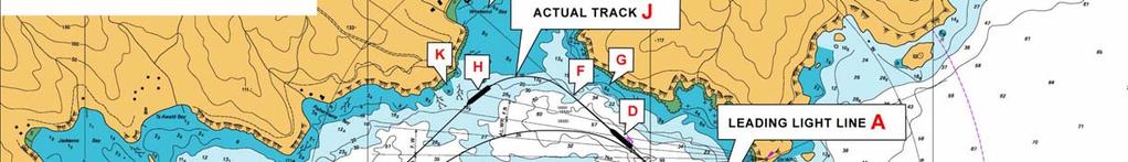
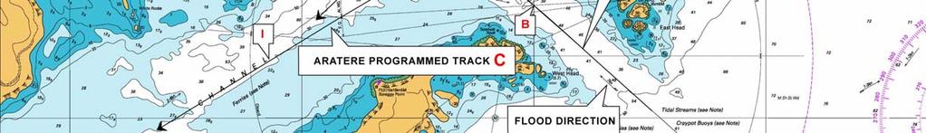
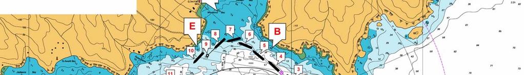
8 In the late afternoon, on 29 September 2004, Aratere gave a 10 minute warning call on VHF channels 16 and 19, of the vessel s entry into the Tory Channel Entrance Controlled Navigational Zone. Subsequently, when the vessel passed East Head abeam to starboard, she was about 30 metres to starboard of her programmed track and the leading light line (Figure 1 - A). The visibility was good with a North Westerly wind of 15 knots and a following spring flood tide. Aratere was operating in automatic track keeping mode, commonly referred to by Interislander personnel as Ants Track. The Chief Officer had the con of the vessel and the Master was present on the bridge for the pilotage through Tory Channel. The vessel had a total complement of 292, comprising 260 passengers and 32 crew. Her draughts were 5.20 metres forward and 5.50 metres aft. After passing East Head, Aratere, which was on a course of 310º(T) at a SOG of 19.5 knots, approached the programmed WOP (Figure 1 - Position B), which would take her onto the next programmed track (Figure 1 - Track C). The Chief Officer, who was monitoring the Ants Track, noticed that the XTE (distance off track) was still to starboard of the leading light line, which the vessel was following to reach the programmed WOP. At this stage, the Chief Officer informed the Master that the distance off track was 40 metres. In response, the Master told the Chief Officer that he had seen the cross track error up to 85 metres with a flood tide. By reference to the Conning Information Display Unit on the IBS, the Chief Officer continued to report an increase in the distance off track from 60 to 70, and then 80 metres (Figure 1 - Position D). Aratere s speed was now knots and the vessel was 320 metres past her programmed WOP. When the distance to starboard of Track C had reached 95 metres, the Master and the Chief Officer realised that on her current heading and speed, the vessel would shortly run aground in Whekenui Bay, Arapawa Island (Figure 1 - Position E). In an attempt to prevent this, the Master overrode the Ants Track system by engaging the manual steering control and putting the helm to port (Figure 1 Position F). At this point Aratere was 555 metres past the WOP and 130 metres to starboard of the next programmed track, Track C. 8
9 It was the evidence of the Master that initially the helm was not put hard to port, as he was concerned that such action might result in the stern passing over charted shoal water (Figure 1 - G). As soon as the Master ascertained visually that the stern was clear of the charted shoal water, he put the helm hard to port. Due to the severity of the turn to port, the vessel s speed of knots was reduced to knots by the time it had reached Figure 1 - Position H. The Master manually steered the vessel back towards her programmed track and then put Aratere back into Ants Track mode for the remainder of the passage (Figure 1 - Position I). In commenting on the draft report, the solicitors instructed on behalf of the Master and Chief Officer, stated that the Master did initially put the helm hard over to port but the slow response time of the two steering motors meant that the rudders did not immediately go hard over but took a few seconds. At about 1820 hours, Aratere berthed at Picton without further incident. The track made good by Aratere (Figure 1 Position J), shows the extent of the deviation from the programmed track, Track C. In so doing, Aratere narrowly missed (80-90 metres) grounding in way of a rock situated to the south of Whekenui Bay (Figure 1 - Position K). 9
10 10
11 NARRATIVE Particulars of Vessel, Ownership, Classification and Bridge Team Aratere is a purpose-built car/rail/passenger RoRo ferry. She was built in Spain in 1997, and Classed 1A1 with DNV. She was reflagged from the Bahamas to New Zealand in October 2003 and registered in Wellington. Aratere is owned by Toll (NZ) Consolidated Ltd (Toll), and operated by Interislander. Toll took over the ownership of the ferry service in early January 2004 from Tranzrail. Aratere is engaged on a regular ferry service between Wellington (North Island) and Picton (South Island). She has a gross tonnage of , an overall length of 150 metres and a maximum beam of metres. She has three cargo decks with passenger and crew accommodation. Two pairs of Wartsila 8L32 medium speed diesel generators, each developing 3300kW at 750RPM, power the vessel. These deliver electrical power to port and starboard engines and shafts (two engines per shaft). Each shaft is fitted with a four bladed, inward turning, fixed pitch propeller. Aratere is also fitted with 1000kW KaMeWa bow thrusters and twin high lift hinged rudders, which are capable of independent operation (i.e. the rudders can be split for manoeuvring purposes). All the vessel s Class Certificates, including her ISM Certificate, were valid at the time of the incident. The bridge is fully enclosed and extends proud of the hull, on the port and starboard side, to assist the master when docking. Aratere has the following navigational equipment: See Figure 2: Schematic diagram showing basic outline Bridge Line 2000 Standard system components Radar 3 centimetre - Norcontrol Databridge 2000 ARPA Radar 10 centimetre - Norcontrol Databridge 2000 ARPA Digital Chart System - Norcontrol GPS -Trimble Navigation NT200D Loran C - Furuno LC90 Mark 2 Autopilot - Norcontrol AP2000 Track AIS - Sailor KDU 1805 Course recorder - EPSOM LX300 Echo Sounder - Skipper GDS
12 NavTex Receiver - JRC NCR 300A Rate of Turn Indicator - C.Plath Digital Repeaters for Gyro Compass Gyro and Magnetic Compasses GMDSS Radio station Figure 2: Schematic diagram - Showing the basic outline of Aratere s Integrated Bridge System, to include the centre console and two docking consoles that are located on the centreline of the vessel and the port and starboard sides of the bridge respectively. Radar s Radar x Dgps Dgps Loran C Anemometer Docking Display Radar/ARPA Conning Info display Radar/ARPA Electronic chart Docking Display Steering stand Bridge watch monitor Chart digitising Remote route planning. Gyro Gyro MTC Speed log Echo Sounder Thrusters, Main engines, Rudder Speed pilot, track pilot Data chief network 12
13 Bridge Team The bridge team on Aratere consisted of the Master and Chief Officer. The Master of Aratere holds a New Zealand Foreign Going Master Certificate of Competency, issued in 1967 and upgraded to STCW 95 in He was promoted to Master by Interislander in At the time of this incident, he had been Master of Aratere for two years and, during this period, he had completed approximately 1000 transits of Tory Channel. He had 16 years sea experience before joining Interislander in 1973, serving throughout the company s fleet as Third Officer, Second Officer, Chief Officer and Relieving Master. He holds Pilotage Exemption Certificates for Wellington, issued in August 1994, and the Marlborough Sounds, including Tory Channel, issued in July He attended a BRM course in July He also attended an Advanced Marine Pilotage Training course in The Chief Officer of Aratere holds a New Zealand Foreign Going Master Certificate of Competency, issued in 1973 and upgraded to STCW 95 in He was promoted to Chief Officer in June 2003 by Interislander. At the time of this incident, he had been serving as Chief Officer on Aratere since April He had 33 years sea experience before joining Interislander in 1994, serving throughout the company s fleet as Third Officer, Second Officer and Chief Officer. He had completed approximately 2000 transits of Tory Channel as a watchkeeping officer at the time of this incident. He holds Pilotage Exemption Certificates for Wellington, and the Marlborough Sounds, including Tory Channel, both of which were issued in April He attended a BRM course in July
.")
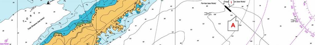
14 Tory Channel Covered by Chart NZ 6153 Queen Charlotte Sound and Chart NZ 6154 Tory Channel Entrance and Picton Harbour. Tory Channel, separated from Queen Charlotte Sound by Arapawa Island, is entered eastwards from Cook Strait between East Head and West Head (Figure 3). The route then leads generally west for about 9 miles before reaching Queen Charlotte Sound. Tidal streams are strong in Tory Channel and very strong at the eastern entrance, attaining a maximum rate of about 7 knots. It was a spring tide on 29 September Data from the New Zealand Nautical Almanac and Chart NZ 6154 shows that at the time the incident occurred, the tidal stream was predicted to be setting 301 (T) and flooding into the eastern entrance of Tory Channel at a rate of about 6.5 knots. This was in way of the magenta tidal diamond marked A that is positioned on the leading light line of '(T) (Figure 3). FIGURE 3 EXTRACT OF CHART 6154, SHOWING THE EASTERN ENTRANCE TO TORY CHANNEL 14
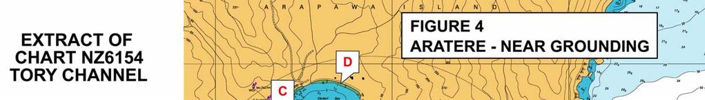
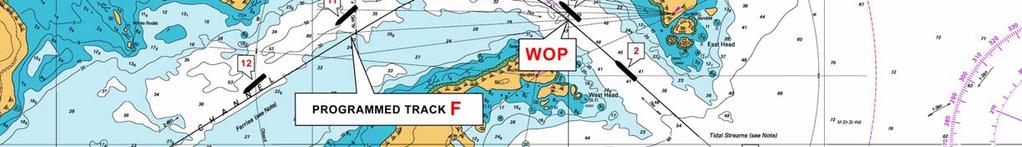
15 THE INCIDENT On 29 September 2004, at about 1525 hours New Zealand Standard Time (NZST), Aratere sailed from Wellington for Picton. There were 260 passengers and 32 crew on board. After leaving her berth in Wellington Harbour, the vessel was put into Ants Track mode. This was standard navigational practice on Aratere. All positions set out below are referenced to Figure 4 (Extract of NZ Chart Tory Channel Entrance and Picton Harbour). At about 1600 hours, the Chief Officer took over the navigational watch from the Third Officer. The Chief Officer stated he was well rested and not fatigued. The weather was a light north-westerly wind of about 15 knots with good visibility. The vessel was on passage in Cook Strait, heading toward the eastern entrance to Tory Channel. At about 1707 hours, the Chief Officer broadcast a radio message on VHF channels 16 and 19 to all ships, giving a 10-minute warning of Aratere s entry into the Tory Channel Controlled Navigational Zone 1 The Master joined the Chief Officer on the bridge shortly after the above radio announcement was made. It was agreed between them that the Chief Officer would retain the con of the vessel and conduct the pilotage through Tory Channel. The Master, who was 10 hours into his 12-hour watch duty period, stated he was not fatigued. The Master had had several short rest periods after coming on duty. In commenting on the draft report, the solicitors instructed on behalf of the Master and Chief Officer, stated the Master had been on duty for approximately 12 hours. At about 1715 hours (Position 1), Aratere was on the leading light line, following the programmed Ants Track (Track A) for the approach to the eastern entrance to Tory Channel. Her heading was 310º(T) with a SOG of 19 knots. The Master checked the operation of the Ants Track by reference to the information displayed on the Conning Information Display Unit (Figure 6). This indicated the IBS was functioning normally in the automatic track keeping mode. At this time, the Master verified the information from the Conning Information Display Unit with reference to the radar and a visual check of the entrance to Tory Channel. Normally, the Master would set the EBL 2 on the radar screen, but on this occasion he did not. The Master set one of the VRM s 3 on the radar screen to give him some indication of the vessel s position off track. However, the Master was not using parallel indexing techniques on the radar screen to be able to verify accurately the vessel s turn position. The Master then went to a desk, which was situated on the bridge behind the IBS console, to complete some paper 1 The seaward extremity of this Zone, when approaching Tory Channel inbound from Cook Strait, is that point forming the intersection of the line of the leading lights, '(T), and the seaward arc of a circle, radius 0.6 nautical miles, centered on West Head Light. This equates approximately to Position 1 Figure 4. The western extremity of this Zone, for ships that are outbound from Tory Channel, is situated along a line that is drawn in a direction of 320 (T) from Scraggy Point Light (Figure 3). The Zone is controlled in the sense that the Marlborough District Council Bylaws 2002, requires the pilot or master (if pilot exempt) of every ship, whether inbound or outbound, to broadcast, or cause to have broadcast, an initial radio message addressed to all ships giving warning of their vessel s transit of the eastern entrance to Tory Channel. This message has to be broadcast not less than 10 minutes before entering the Tory Channel Controlled Navigational Zone. 2 Electronic Bearing Line 3 Variable Range Marker 15
16 work. In commenting on the draft report, the solicitors instructed on behalf of the Master and Chief Officer, stated that neither the Master nor the OOW used parallel indexing because the system on Aratere is extremely cumbersome using Norcontrol and the time taken from East Head to Scraggy Point is very short. They said it is standard operating practice to put the VRM on 0.13 nautical miles (which was done in this case) and to use the south shore as a distance for radius curve turning. At or about 1716 hours, Interislander s Health and Safety Manager arrived on the bridge with a contractor. The purpose of his visit was to show the Master the results of a safety inspection that he had carried out on board the vessel with the contractor. At this time, the Master was still working at the desk behind the IBS console, whilst the Chief Officer was standing at the Conning Information Display Unit, monitoring the Ants Track system. The Health and Safety Manager had a brief conversation with the Master regarding the findings of his inspection. It was the evidence of the Health and Safety Manager that whilst this conversation was taking place, the Chief Officer made a comment to the Master that the vessel was moving to starboard of the programmed Ants Track. In commenting on the draft report, the solicitors instructed on behalf of the Master and Chief Officer, stated that the Master did not go to a desk that was situated behind the IBS console. They said he was standing beside the stabiliser controls and then moved alongside the OOW as Aratere entered Tory Channel. They went on to say that while the Master had previously been talking to the Safety Manager, he had moved to the stabiliser controls by the time the vessel had reached East Head. Thereafter, any conversation that the Master had with the Safety Manager was very limited and was conducted over his shoulder. At 1716 hours, East Head was passed abeam to starboard (Position 2). Information taken from the VDR, showed Aratere was on a heading of 311º(T) with a SOG of 19.2 knots. Her position was approximately 30 metres to starboard of the leading light line and the vessel s programmed track. Aratere s WT speed was recorded on the VDR at knots. Data from the VDR, showed the tide was flooding into the entrance at a rate of approximately 3.9 knots at this time. Very shortly after this, the Chief Officer acknowledged an alarm from the IBS. At the time of his interview, the Chief Officer could not recall which sensor system had alarmed. However, he did not think it was the DGPS alarm sensor system, which had been installed by Wright s Technologies Limited, on behalf of Interislander, following several previous losses of the DGPS position fixing signal on earlier passages. 16
17 The Master, who confirmed hearing the Chief Officer s observation and the alarm, assumed it was the 30-second alarm warning the bridge team of the vessel s approach to the next WOP (Position WOP). The Master, who was still at his desk, then continued his conversation with the Health and Safety Manager. Very shortly afterwards, the Chief Officer told the Master that the vessel was continuing to move to starboard of the programmed Ants Track to 40, 50 and then to 60 metres. At this point, the Master broke off his conversation with the Health and Safety Manager and went to the IBS console. It was the evidence of the Health and Safety Manager that he then left the bridge. He informed the Investigator that his conversation with the Master had lasted for about 20 seconds. This occurred at a time when Aratere was either approaching or was in the near vicinity of the programmed WOP. As Aratere entered Tory Channel, the speed of the vessel started to increase due to the following spring flood tide. In addition, she continued to experience starboard set to the east of the programmed track and the leading light line of '(T). The Chief Officer continued to monitor the Ants Track on the Conning Information Display unit. He told the Master the distance off track was continuing to increase to starboard of the track. In response, the Master stated he had previously experienced distances off track of up to 85 metres with a following flood tide at the entrance to Tory Channel. Shortly after 1717 hours, Aratere, which had passed the WOP for the next programmed track (Track F), was now approximately 70 metres to starboard of that track (Position 3), on a true heading of 307º(T). The Chief Officer kept reporting the increments in distance off track to the Master. At Position 4, the Chief Officer told the Master the distance off track had reached 95 metres. From the VDR, the heading of the vessel at this time was 309º(T). At this point, the Master and the Chief Officer realised that on her present heading and speed, Aratere would ground shortly in Whekenui Bay (Position C), unless evasive action was taken. Accordingly, the Master overrode the Ants Track system by engaging the manual steering control. During the course of his interview, the Master stated he initially put the helm 20º to port, as he was concerned the vessel s stern might ground in the charted shoal water (Position B), if the helm was immediately put hard to port. The evidence from the VDR shows that the rudders were initially put 20º to port, followed by hard to port. Information taken from the vessel s VDR at about 1718 hours (Position 5), when Aratere was approximately 120 metres to starboard of Track F, shows that the vessel s average speed from the WOP was knots SOG. Her course at this time was 312º(T). The maximum speed recorded on the VDR was knots SOG. The vessel s WT speed was recorded at knots, indicating a tidal flow of approximately 4.75 knots. 17
18 Very shortly after reaching Position 5, the helm was manually put hard to port. This equated to an interval of approximately 50 seconds elapsing from the time Aratere passed the WOP, and to a distance run from this point of about 600 metres (just over 3 cables) or about four times the overall length of the vessel. The courses and speeds of Aratere, thereafter, were as follows: - Position 6. Helm of Aratere still hard to port. True heading 289º(T), COG 307º(T), SOG 20.3 knots. Position 7. True heading 257º(T), COG 301º(T), SOG 18 knots Position 8. True heading 231º(T), COG 287º(T), SOG knots. Position 9. True heading 226º(T), COG 276º(T), SOG knots. Position 10. True heading 221º(T), COG 259º(T), SOG knots. From the plotted position shown at Position 10, the distance the vessel s stern passed off the charted rock (Position E), situated just inside the 10 metre sounding contour line, was estimated to be metres. This rock was charted as being awash at the level of chart datum. Position 10. At this point, Aratere s speed had reduced to knots SOG. This reduction in speed, from 20.6 knots at Position 6, was due solely to the severity of the turn to port. After Aratere had completed her turn to port, the Master manually steered the vessel towards Track F (see Positions 10, 11 & 12). At about 1721 hours, in Position 12, the Master received a telephone call from the Marlborough District Harbourmaster at Picton. The Master was asked if Aratere had been experiencing any difficulties in Tory Channel as a witness from ashore in Okukari Bay (Position D) had reported the incident to the Harbourmaster. Due to the extent of the vessel s deviation from her normal track, the witness had been concerned that Aratere might have experienced mechanical problems and be in need of assistance. After explaining the position to the Harbourmaster, the Master telephoned the Operations Manager of Interislander and informed him of the situation. At about 1723 hours, when Aratere was steady on Track F, heading 240º(T) at a SOG of 20.1 knots, the Master put Aratere back into Ants Track mode for the remainder of the passage. The Chief Officer kept the con of the vessel. Aratere then continued in Ants Track mode toward Picton, where the vessel berthed at about 1820 hours without further incident. The Maritime Safety Authority was first informed of the incident by the Marlborough District Harbourmaster at about 0815 hours the following day, 30 September. This 18
19 was followed almost immediately by an from the management of Interislander, that was sent at about 0830 hours, advising of the incident. 19
20 20
21 COMMENT & ANALYSIS EVIDENCE On 30 September 2004, the Maritime Safety Authority commenced an immediate investigation into the near grounding of Aratere. The assigned Investigator interviewed the Master and Chief Officer of Aratere. Information was also obtained from: Port officials at Picton. A witness ashore at Okukari Bay, Arapawa Island. DNV - Aratere s Classification Society. Kongsberg Maritime AS (Norcontrol), the manufacturers of the IBS onboard Aratere. Interislander personnel. Wright Technologies Limited (Electronic technicians, contracted by Interislander for the IBS). Maritime Safety Authority. IMO. In addition to the above, copies of the ship s relevant ISM documents, logbooks, voyage data recorder information and manuals on the IBS of Aratere were obtained by the Investigator. ANALYSIS A. Observations of a Round Trip Conducted on Aratere The Investigator completed one round trip on Aratere after the incident. The purpose of the trip was to gain a practical insight into the operation of the IBS, the navigation of the vessel, and the bridge resource management techniques employed by the bridge team. The following observations were made: 21


22 The echo sounder was switched off throughout the entire (round trip) voyage, including the Wellington and Queen Charlotte Sound pilotage districts, which include Tory Channel. International best practice and STCW 95 recommend the use of an echo sounder when in pilotage waters as a useful navigational aid. No positions or courses were plotted on official paper charts, either on sea passage in Cook Strait or in pilotage waters. A chart was produced only when the Investigator requested one. The Investigator was informed by the bridge team that this was standard navigational practice on Aratere, notwithstanding that the use of paper charts is a requirement of STCW 95 for this particular vessel. Position verification throughout the voyage was limited by reference to the ship s electronic chart display information system (ECDIS) and the course lines transposed on the radar screens. There was no use of parallel indexing techniques in pilotage waters for verification of the vessel s position. This was again stated to be standard practice on Aratere. Whilst entries were made in the deck log, with reference to the vessel s position, these positions were not verified on official paper charts as per STCW 95 requirements. The electronic charts used on Aratere were last corrected for navigational accuracy on 19 November The Investigator was informed by the bridge team that the computer CD Rom drive, which enables a bridge team to correct the electronic charts, had become defective within a month of the above date. This was reported by the vessel s masters to Interislander Management who, in turn, informed the Investigator that the cost of replacing the CD Rom drive (NZ$ ), was considered too costly. Further, they stated that a replacement drive was unnecessary as Aratere was an official paper based chart vessel. Interislander pointed out that safety signage had been placed on the chart plotter console on the bridge to reflect this (Figure 5). Notwithstanding this fact, no paper charts were used for the navigation of the vessel. FIGURE 5 SIGNAGE ON ELECTRONIC CHART CONSOLE The Investigator observed that whilst the bridge team was conversant with the practical operation of the IBS, their knowledge of the basic programming of the 22
23 system with respect to changing navigational waypoints, amending the passage plans or obtaining information on the preset sensor alarm values, such as XTE warnings, was limited. Moreover, the bridge team did not know the source of information, which would enable them to check the accuracy of the DGPS, which was interfaced with the IBS and used to determine the ship s position. The Investigator was told by the bridge team, that they had not received any formal training for the operation of the IBS. Further, that no proper procedures for the operation on the IBS had been issued by Interislander as per the IMO guidelines for the use of the system. The bridge team felt that a properly structured training course for the operation of the IBS would have been beneficial. B. Integrated Bridge System There is no single standard IBS design for ships. Further, the fitment of IBS is not a mandatory requirement, either of IMO, SOLAS, or Classification Societies, such as DNV. IMO/SOLAS have, however, issued minimum performance standards for the operation of IBS, to which manufacturers are required to comply before such equipment can be installed on board vessels. Aratere complied fully with these standards. C. Explanation of the Integrated Bridge Management System (IBS) on Aratere An integrated bridge system is a combination of systems such as radar inputs, navigational inputs, speed log inputs, and course related inputs, which are interconnected to allow the centralised monitoring of sensor information by the IBS management system. In addition, the navigation management system within the IBS controls a number of operations such as passage execution, communications and machinery control (See Figure 2). D. The Purpose of the Navigation Management System The navigation management system provides the mechanism for planning, executing and monitoring the ship s passage plan. It provides the link between the electronic charts, on which the vessel s programmed track has been planned, the position-fixing systems (DGPS), the water speed log, gyro, radar, and the autopilot. The electronic chart information system typically functions as the display of the navigation management system within the IBS, supported by a dedicated route planning terminal to allow route planning activities to be undertaken while on passage. 23
24 E. The Auto Pilot on Aratere The autopilot allows Aratere to be steered automatically. It can be operated in the following operational modes:- Independently: this is known as Course-Keeping Mode and enables a watchkeeping officer to enter the vessel s heading into the autopilot manually. In this mode, the IBS is not integrated with the autopilot and the vessel will remain on the heading set by the watch-keeping officer until such time as he manually changes the heading by selecting a new course to be steered. When the IBS is integrated with the autopilot, the system controls the autopilot in one of two different modes of operation: Automatic Track Keeping Mode (Ants Track) and, Waypoint Mode. In either mode, the autopilot receives XTE s from the IBS computer system. In this manner, dynamic forces, such as wind, tide and current, which can cause the vessel to move off her programmed track, are registered as a XTE within the IBS. This in turn, sends commands to the autopilot to counteract these forces and keep the vessel on track without any human interface. The Difference Between Automatic Track Keeping Mode and Waypoint Mode Automatic Track Keeping Mode (Ants Track): This allows Aratere to maintain its programmed track by automatically counteracting any dynamic forces. In automatic track-keeping mode, the autopilot is adaptive and able to perform course alterations automatically between programmed track legs, using either a pre-set turn radius or rate of turn values. These course alterations are commenced at a WOP such as that shown on Figure 4. When operating in automatic tracking mode the watch-keeping officer is notified by the IBS of the vessel s near approach to the WOP. This is achieved by an audible alarm, which is activated 30 seconds before reaching the WOP. Waypoint mode: This ensures the heading of the ship is kept pointing toward a particular preset navigational waypoint (toward a programmed point) and, if the wind, tide and current moves the ship off track, the IBS simply gives the autopilot a new course to steer in order to reach the programmed waypoint. It does not take into consideration what track the vessel was originally on, as is the case when operating in automatic track keeping mode. 24
25 F. Alarm System on Aratere The IBS on Aratere is fitted with an alarm system to warn a watch-keeping officer when a potentially dangerous situation arises, such as the loss of the DGPS position fixing system or the breach of a programmed XTE. The watch-keeping officer should be in no doubt as to what the alarm is for and what response is required in the event of a system failure. The main navigational sensors, to which alarm systems are fitted on Aratere include: The radar - which provides traffic alarms. The gyro and autopilot - which provide course related alarms including the approach to a waypoint. The position fixing system (DGPS) - which provides position related alarms, including the approach to a waypoint. The speed log (WT) - which provides information on the vessel s movement through the water. In the event of an equipment malfunction or loss of sensor information, the IBS is set to alarm and revert immediately from either automatic track keeping mode or waypoint mode to course keeping mode. This will occur even after an alarm has been acknowledged. Once in course keeping mode, the vessel is programmed to maintain her previously set course and speed until such time as the watch keeping officer manually re-sets the autopilot course, changes over to manual steering or puts the IBS into another steering mode. If the vessel has already commenced a turn in automatic track keeping mode, and there is then a loss of sensor information, the IBS will complete the vessel s turn automatically. This will be based on the vessel s ROT that is pre-programmed into the autopilot. After completing the turn, the vessel will continue on the next programmed track, in course keeping mode, and manual intervention is required by the watchkeeping officer to conduct any further course alteration, whether this be for navigational purposes or collision avoidance. XTE Alarm A XTE alarm is programmed for each track. This has a preset alarm value, which equates to the maximum distance the vessel is allowed to deviate from her programmed track before the XTE alarm sounds. Unlike the position in the event of an equipment malfunction or loss of sensor information, the breach of a pre-set XTE does not cause a change in steering mode. Accordingly, if already operating in automatic track keeping mode, a watch officer has to intervene and override the IBS manually, if required for the continued safe navigation of the vessel. G. Conning Information Display Unit 25


 on Aratere s IBS The Investigator put a number of questions relating to the IBS on Aratere to Kongsberg Maritime AS, the Norwegian")
26 The display unit on Aratere (Figure 6), gives information summaries of the important navigational sensors used on the vessel s passage, such as DGPS, speed log, gyro, XTE and the steering mode in which the IBS is operating; such as Ants Track. Conning Display Unit Rudder controls Alarm panel BWMS Auto pilot FIGURE 6 CENTRE CONSOLE ON THE BRIDGE OF ARATERE H. Aratere s Navigation Satellite System The IBS on Aratere receives positions from a Differential Global Positioning System (DGPS). Corrections to raw GPS signals from orbiting satellites are determined and transmitted, using a HF radio link, by a terrestrial monitoring station. This is operated by an electronics company based in Wellington. Whilst operating within DGPS coverage, position accuracy of the vessel is enhanced. I. Comments of Kongsberg Maritime AS (Norcontrol) on Aratere s IBS The Investigator put a number of questions relating to the IBS on Aratere to Kongsberg Maritime AS, the Norwegian manufacturer of this system. These questions, together with the responses from Kongsberg Maritime AS, are set out below: 26
27 Q. Is it possible that the Master and Navigation Officer missed a navigational sensor alarm and the vessel moved into a different steering mode, such as from automatic track keeping mode to course keeping mode? Alternatively, could the IBS move from one steering mode to another without the watch-keeping officer knowing? It was reported that the vessel was in automatic track keeping mode at the time of the incident. A. The navigation officer(s) can only miss such alarms if the alarm buzzer is defective and the blinking alarm indication on the conning display screen is ignored or not noticed. A change in steering mode is possible when, for example, a sensor fails (GPS, speed log, etc.). In such case, audible and visible alarms are given. The autopilot can change its mode automatically, but this happens only following an error causing a navigational sensor alarm (including audible signals). The steering mode can also be changed manually on the AP operating panel by the navigation officer. There is no extra alarm after a sensor alarm has sounded when the autopilot changes mode. Alarms are only given in relation to the reasons that may cause it to change mode namely, what sensor has failed. Q. Could an alarm be programmed into the IBS to alert the navigation officer when passing a WOP? A. No. Software wise such alarms could be implemented but we will do this only if required by IMO/SOLAS regulations. Q. The bridge team referred to the cross track error as being the distance off the programmed track. Is any error displayed on the conning information display unit that the vessel has gone past the WOP, in terms of distance? A. No. Software wise such alarms could be implemented but we will do this only if required by IMO/SOLAS regulations. Summary from Kongsberg Maritime AS on the Incident In general, automatic steering is more effective than manual due to the fact that the computer is able to react faster to cross track errors than a human being. This is also valid for steering through tidal flows of up to 7 knots, as with the entrance to Tory Channel. There are however a number of things that may cause an automatic steering failure (jumps in GPS positions, Water log failures, etc.). In such cases audible and visible alarms are given. When sailing on automatic track steering through difficult passages like the Tory channel entrance it is imperative that the navigation officer(s) stay 100% alert to take over using manual steering if anything happens to the automatic steering. This also includes keeping an eye on the cross track error displayed. 4 AP 2000 autopilot onboard Aratere 27
28 From the chart (See Figure 4) showing the planned and actual route it is likely that one of the following has occurred:- A cross track alarm has been issued and not properly handled by the navigation officer. The officer, when the XTE limit is exceeded has to monitor the deviation closely. If the autopilot continues in auto tracking mode and appears to handle the situation, such as when there are small deviations from the XTE limit, human intervention is not necessarily required. On large deviations from the XTE limit, however, (or if auto tracking is terminated), the officer needs to bring the vessel back on track manually. The track control system performs a continuous test of the inputs from the navigational sensors used for track steering, i.e. gyro compass, speed log and navigation receiver (GPS). If there is a large abnormality from these signals (or an unreasonable value related to previous readings), the DB will decide that there is a serious error. This will be alarmed and automatic tracking will be terminated. On a straight leg, as occurred in this incident (See Figure 4), the steering will then continue but this time in Autopilot mode (Heading Control) 6. The heading will be the heading of the ship when the automatic track steering was terminated. In a turn 7, where a sensor fails for whatever reason, the system will complete the turn based on the ROT, and continue on the heading of the leg leaving the turn (the course of the next programmed track). If the abnormality is small, the DB 2000, will assume that the calculated variation in XTE is due to some external influence and will try to control the rudders to reduce the XTE. Automatic track steering will then be continued. As long as the automatic track steering continues, it will continue to control the rudders in order to reduce the XTE. This will also occur if the XTE has reached values above the XTE limit. 5 IBS onboard Aratere 6 Course keeping mode, human intervention required to change course. 7 Alteration of a vessel s course at WOP 28
29 Based on the evidence obtained in the course of the investigation and on the answers from Konsberg Maritime AS to the technical questions that were put to them, the Investigator considers that the following two scenarios represents the most likely sequence of events leading up to the incident: Scenario One Aratere is in automatic track keeping mode (Ants Track) maintaining a heading of 310º(T). Before reaching the WOP (Figure 4 WOP), and turning automatically onto the next programmed track (Figure 4 Track F), an IBS navigational sensor, such as DGPS or WT, alarms and is acknowledged by the Chief Officer. As the vessel has already started to deviate to starboard of her programmed track when the navigational sensor alarms, the Chief Officer assumes (erroneously) that it is the XTE alarm, which he acknowledges. Whilst focusing on the increasing increments of the vessel s deviation to starboard of Track F, the Chief Officer and subsequently the Master fail to note that as a result of the sensor alarm sounding, the automatic track-keeping mode has terminated and the system has reverted to course-keeping mode. This would have occurred without any further alarm sounding, although the change of steering mode would have been displayed visually on the conning information display unit. Because the vessel is on a straight track, at the time the change of steering mode occurs, the vessel maintains the heading she is already on, [310º(T)], at the time automatic track-keeping mode is terminated. The vessel continues on a heading of 310º(T) until the Master intervenes and manually overrides course-keeping mode, by changing over to manual steering and putting the helm over to port. In commenting on the draft report, the solicitors instructed on behalf of the Master and Chief Officer, stated that the Ants track mode did not revert to automatic. The OOW was waiting for the track to clear, which would indicate the machine was looking for its next course but this did not happen. Later, the OOW was told by a representative from Wrights Technologies that this might happen once every times. 29
30 Scenario Two Aratere is in automatic track-keeping mode (Ants Track) maintaining a heading of 310º(T). Before reaching the WOP (Figure 4 - WOP), and turning automatically onto the next programmed track (Figure 4 - Track F), an IBS navigational sensor, such as DGPS or WT, has a small technical error. Errors in the signals from speed logs may occur in areas where there is a sudden change in depth, current or salinity, as is the case at the eastern entrance to Tory Channel. There may also be errors in signals from the GPS when there is a sudden changeover in the satellites being used, and the concomitant change between absolute and differential modes. Other possible errors included satellite masking caused by local topography or the differential signal being lost intermittently from the correction station. Electrical noise may also introduce errors. This small error is calculated as a XTE and the IBS continues in automatic track-keeping mode, albeit the XTE continues to increase. The Chief Officer accepts the 30 second WOP alarm and makes an assumption (erroneously) that the vessel will alter her heading onto Track F. The next alarm, the 60 metre XTE alarm, is heard and accepted. Aratere continues to move to starboard of the track and fails to execute the programmed turn onto Track F. The vessel continues on a heading of 310º(T) until the Master intervenes when the XTE is 120 metres to starboard of Track F. He then manually overrides the automatic tracking mode by changing over to manual steering and putting the helm over to port. Kongsberg Maritime AS stated that the behaviour of the automatic track-keeping mode in this incident was abnormal and that they did not know the exact reason for this behaviour. In their opinion, abnormal signals or sequences of signals from navigational sensors (GPS, gyro, speed log) can have different effects depending on the abnormality. In commenting on the draft report, the solicitors instructed on behalf of the Master and Chief Officer, stated that the DGPS did not revert to DG. They went on to state that by reason of their clients close monitoring of the vessel s progress, they assumed manual control of the vessel and prevented any further trouble after the Ants had failed to identify or respond to the WOP. 30
31 J. IMO Guidance Notes for the Use of IBS The following is text in italics taken from the IMO under MSC (Maritime Safety Circular) circ Non-italicised text represents the Investigator s comments. IMO invites member governments to bring this guideline to the attention of all parties concerned. There is no evidence that the MSA highlighted this document to Interislander on Flag State Inspections, either directly or by the issuance of a Marine Notice. GUIDANCE FOR THE OPERATIONAL USE OF INTEGRATED BRIDGE SYSTEMS. This guidance supports the safe operational use of an IBS by promoting procedures necessary to ensure adequate knowledge of system functions for Mode Awareness, Situational Awareness and Workload Management in addition to traditional seamanship. The aim is to define the basis for minimum criteria on the operation, training and quality control for Integrated Bridge Systems. This guidance is relevant to the operation of ships fitted with Integrated Bridge Systems IBS, as per resolution MSC.64(67), Annex 1, which include Integrated Navigation Systems INS (B) or (C), as per resolution MSC.86(70). For the purpose of this guidance, the following definitions apply. Mode awareness is based on the knowledge and purpose of various operation modes included in the IBS. Use of different operation modes should follow bridge procedures based on company automation policy. The Master and Chief Officer informed the Investigator they were unaware that any automation policy had been developed by Interislander for Aratere. Their knowledge of the various operation modes within the IBS was limited. Moreover, neither the Master nor the Chief Officer had received any formalised training on the use of the IBS. This shortfall in training by Interislander was reflected by the bridge team s lack of mode awareness at the time of the incident. Situational awareness is the mariner s perception of the navigational and technical information provided at the INS 8 workstation, the comprehension of their meaning and the projection of their status in the near future, as required for timely reaction to the situation that can be expected from his/her trained skills in the operation of the INS. 8 Integrated Navigation Systems/IBS 31
32 Notwithstanding, the fact that both the Master and Chief Officer were aware that the Ants Track system (automatic track-keeping mode), could revert to course keeping mode, based on previous experiences with the system, they nevertheless failed to closely monitor the progress of the ship at a critical juncture in the vessel s passage plan. This demonstrated reduced situational awareness at a time when the projection of their status in the near future was paramount for the continued safe navigation of the vessel. Bridge Procedures The bridge procedures, provided for the ship, should implement the functions, capabilities and limitations of the installed IBS. Especially, the documentation should include clear instructions about conditions under which automatic control functions may be used or not. None of the above had been implemented fully by Interislander at the time of the incident. The Company should have personnel ashore capable of supervising, training and evaluating the company Operational Procedures and operational use of the Integrated Bridge System. The Operations Manager of Interislander had received formal training in the use of the IBS. The Vessel Operating Manual (VOM) should incorporate the Company policy for implementing and using automation and the Integrated Bridge System. The operational manual consolidates and abbreviates the manufacturer s operational manuals to a comprehensive operational manual without detailed technical information. The VOM should clarify the integration and the priority of sub-systems within the control system. Special emphasis should be laid on the effect of sub-systems on the total outcome of navigation control. Advantages and disadvantages between control and automation modes should be explained in a clear form. It should be clearly indicated for which situations the different modes are designed. The VOM should indicate corrective actions to be taken when the system gives alarm. Operating limitations and their reasons should be thoroughly explained. A description of the checklists and purpose of the specific items should be included in the VOM. Terminology for standard Call-outs should be developed by the Company and presented in the VOM. No vessel operating manual (VOM) existed for Aratere at the time of the incident. Interislander advised the MSA that ship s masters and officers had access to the manufacturers manuals for information on the operation of the IBS. The standard operating procedures should be documented in the form of checklists demonstrating transition from one zone to another. The items to be listed are e.g. manning of the bridge and the use of automated equipment including the selection of subsystems and their modes of operations. 32
Incident Report. Close Quarters Situations Challenger, Aratere & Lotus. 21 February 2006
 Incident Report Close Quarters Situations Challenger, Aratere & Lotus 21 February 2006 NARRATIVE On 20 February 2006, at about 1600 hours New Zealand Daylight Time (NZDT), a Skipper and an agent from KMS
MARINE OCCURRENCE REPORT TRANSPORT ACCIDENT INVESTIGATION COMMISSION NEW ZEALAND. 29 September 2004
 MARINE OCCURRENCE REPORT 04-214 passenger freight ferry Aratere, loss of mode awareness leading to near grounding, Tory Channel 29 September 2004 TRANSPORT ACCIDENT INVESTIGATION COMMISSION NEW ZEALAND
Incident Report. Close Quarters Pegasus II & Distraction. 26 April 2006 Class B
 Incident Report Close Quarters Pegasus II & Distraction 26 April 2006 Class B NARRATIVE Pegasus II (See Photograph 1 Pegasus II) is a 15.46 metre commercial fishing vessel with a gross tonnage of 40. She
ASSESSMENT. Heavy Weather Passage Challenger (Kaitaki) 24 October 2006
 24 October 2006") ASSESSMENT Heavy Weather Passage Challenger (Kaitaki) 24 October 2006 1 INTRODUCTION On 24 October 2006, the Cook Strait ferry Challenger sailed from Picton to Wellington encountering storm force conditions.
ASSESSMENT Heavy Weather Passage Challenger (Kaitaki) 24 October 2006 1 INTRODUCTION On 24 October 2006, the Cook Strait ferry Challenger sailed from Picton to Wellington encountering storm force conditions.
properly applied assessment in the use.1 landmarks.1 approved in-service of ECDIS is not experience The primary method of fixing required for those
 STCW Code Table A-II/3 Specification of minimum standard of for officers in charge of a navigational watch and for masters on ships of less than 500 gross tonnage engaged on near-coastal voyages Ref: https://www.edumaritime.net/stcw-code
TECHNICAL CIRCULAR. Circular No: S-P15 /13 Revision: 0 Page: 1 of 9 Date:
 Circular No: S-P15 /13 Revision: 0 Page: 1 of 9 Date:25.04.2013 Related Requirement: UR N1 Subject: One man bridge operated (OMBO) ships Note: For ships contracted for construction as defined in IACS PR29
 ON SHIPS OF 200 GRT/500 GT OR MORE Assessment Sheets Enclosure (1) to CG-543 Policy Letter 11-07 ASSESSMENT NO. OICNW-1-1A COMPETENCE: Plan and conduct a passage and determine position KNOWLEDGE, UNDERSTANDING
RESOLUTION MSC.161(78) (adopted on 17 May 2004) AMENDMENTS TO THE EXISTING MANDATORY SHIP REPORTING SYSTEM "THE TORRES STRAIT AND INNER ROUTE OF THE
 (adopted on 17 May 2004) AMENDMENTS TO THE EXISTING MANDATORY SHIP REPORTING SYSTEM THE TORRES STRAIT AND INNER ROUTE OF THE") MSC 78/26/Add.2 RESOLUTION MSC.161(78) REPORTING SYSTEM THE TORRES STRAIT AND INNER ROUTE OF THE GREAT BARRIER REEF THE MARITIME SAFETY COMMITTEE, RECALLING Article 28(b) of the Convention on the International
MSC 78/26/Add.2 RESOLUTION MSC.161(78) REPORTING SYSTEM THE TORRES STRAIT AND INNER ROUTE OF THE GREAT BARRIER REEF THE MARITIME SAFETY COMMITTEE, RECALLING Article 28(b) of the Convention on the International
MARINE NOTICE MARINE NOTICE. Marine Notice 7/2012. Guidance on ECDIS for ships calling at Australian ports 7/2012
 MARINE NOTICE MARINE 7/2012 NOTICE Marine Notice 7/2012 Guidance on ECDIS for ships calling at Australian ports This notice aims to clarify some of the emerging issues relating to the carriage requirements
SOLAS requirements for nonpassenger ships 300 or above but less than 500 gross tonnage
 SOLAS requirements for nonpassenger ships 300 or above but less than 500 gross tonnage Guidance for owners, masters and surveyors for ships undertaking international voyages SOLAS requirements applied
PASSENGER SHIP SAFETY. Review of Operational Safety Measures to Enhance the Safety of Passenger Ships. Submitted by ICS SUMMARY
 MARITIME SAFETY COMMITTEE 92 nd session Agenda item 6 MSC 92/6/XX 2013 Original: ENGLISH PASSENGER SHIP SAFETY Review of Operational Safety Measures to Enhance the Safety of Passenger Ships Submitted by
iii) Satisfactory completion of approved training in the following:
 Satisfactory completion of approved training in the following:") Enclosure (1) to NVIC 13-14 DISCUSSION OF QUALIFICATION REQUIREMENTS FOR MASTER AND OFFICER IN CHARGE OF A NAVIGATIONAL WATCH ON VESSELS OF LESS THAN 500 GT LIMITED TO NEAR-COASTAL WATERS 1. GENERAL. This
Enclosure (1) to NVIC 13-14 DISCUSSION OF QUALIFICATION REQUIREMENTS FOR MASTER AND OFFICER IN CHARGE OF A NAVIGATIONAL WATCH ON VESSELS OF LESS THAN 500 GT LIMITED TO NEAR-COASTAL WATERS 1. GENERAL. This
PILOTAGE DIRECTIONS REVIEWED DECEMBER 2016
 PILOTAGE DIRECTIONS REVIEWED DECEMBER 2016 REVISION LIST Revision No. Date Details Approved by: Original All sections 12 Dec 2013 First edition of C W Brand v1.0 Pilotage Directions Revision 2 all sections
RESOLUTION A.817(19) adopted on 23 November 1995 PERFORMANCE STANDARDS FOR ELECTRONIC CHART DISPLAY AND INFORMATION SYSTEMS (ECDIS)
 adopted on 23 November 1995 PERFORMANCE STANDARDS FOR ELECTRONIC CHART DISPLAY AND INFORMATION SYSTEMS (ECDIS)") A 19/Res.817 15 December 1996 Original: ENGLISH ASSEMBLY 19th session Agenda item 10 RESOLUTION A.817(19) adopted on 23 November 1995 PERFORMANCE STANDARDS FOR ELECTRONIC CHART DISPLAY AND INFORMATION
A 19/Res.817 15 December 1996 Original: ENGLISH ASSEMBLY 19th session Agenda item 10 RESOLUTION A.817(19) adopted on 23 November 1995 PERFORMANCE STANDARDS FOR ELECTRONIC CHART DISPLAY AND INFORMATION
OFFICIAL MESSAGE CIRCULAR
 OFFICIAL MESSAGE CIRCULAR From: NI/ DP Department Number: 010/2012 Date: 20.12.2012 Number of pages: 7 To: Dynamic Positioning Accredited Training Centres Cc: DPTEG members Referent to: Aims and Objectives
ECDIS Familiarisation Training
 Chapter 4 ECDIS Familiarisation Training The convention related to the qualifications of seafarers responsible for ship operation is STCW (International Convention on Standards of Training, Certification
National Standard for Commercial Vessels
 National Standard for Commercial Vessels Part E Operations Published 17 May 2013 Endorsed by the Standing Council on Transport and Infrastructure 10 May 2013 Commonwealth of Australia This work is copyright.
Gorgon - Pilotage - Passage Plan - PBG to Gorgon Marine Terminal - Alternative Route
 1.0 Introduction This work instruction outlines the passage plan to be used by vessels transiting from the Port of Barrow Island PBG to the Gorgon Marine Terminal, via the alternative route, with a Pilot
Forth Ports Limited. Port of Dundee. Rig Move Guidelines
 Forth Ports Limited Port of Dundee Contents 1 Introduction... 4 2 Pre-Arrival... 4 2.1 Planning Meetings... 4 2.2 Priority of Movements... 4 2.3 Confirmation/Cancellations... 5 2.4 Weather Parameters...
Uncontrolled document if printed.
 APPENDIX 3 APPRENTICE PILOT S TRAINING SYLLABUS Issue Date: 16 th March, 2010 Date of Revision: 22nd May, 2013 Revision #2 i THE PURPOSE OF THIS SYLLABUS The purpose of this training syllabus is to ensure
NAVIGATION ACCIDENTS AND THEIR CAUSES IS SHIPBOARD TECHNOLOGY A HELP OR HINDERANCE? CAPT.CLEANTHIS ORPHANOS MSc HEAD MAIC SERVICE
 NAVIGATION ACCIDENTS AND THEIR CAUSES IS SHIPBOARD TECHNOLOGY A HELP OR HINDERANCE? CAPT.CLEANTHIS ORPHANOS MSc HEAD MAIC SERVICE Shipboard Technology Radar/Arpa ECDIS GPS/DGPS/ LRIT VDR Loran Gyro compass
MANAGEMENT SYSTEM MANUAL
 1. Purpose The purpose of this procedure is to establish routine check-off lists to be used in preparation for arrival and departure aboard the R/V Oceanus. 2. Responsibility The Master is responsible
ADMINISTRATIVE INSTRUCTION No. STCW-14 QUALIFICATION / CERTIFICATION REQUIRED FOR OPERATION OF A DOMESTIC VESSESL
 ADMINISTRATIVE INSTRUCTION No. STCW-14 QUALIFICATION / CERTIFICATION REQUIRED FOR OPERATION OF A DOMESTIC VESSESL (Issued under section 3(5) of the Gibraltar Merchant Shipping (Safety etc.) Ordinance 1993
NAEST(M) training Course Structure and Session Objectives. Day Introduction and enrolment
 training Course Structure and Session Objectives. Day Introduction and enrolment") NAEST(M) training Course Structure and Session Objectives Day 1 0830-0930 Introduction and enrolment 0930-1330 Effective Bridge Procedures & Rule of the Road Lecturer will go through the PowerPoint on
NAEST(M) training Course Structure and Session Objectives Day 1 0830-0930 Introduction and enrolment 0930-1330 Effective Bridge Procedures & Rule of the Road Lecturer will go through the PowerPoint on
Gorgon - Pilotage - Passage Plan PBG to Materials Offloading Facility (MOF)
") 1.0 Introduction Vessels transiting within port limits from the Barrow Island Pilot Boarding Ground (PBG) to the require an approved passage plan which can be shared between Pilots and vessel Masters.
1.0 Introduction Vessels transiting within port limits from the Barrow Island Pilot Boarding Ground (PBG) to the require an approved passage plan which can be shared between Pilots and vessel Masters.
Report on Vessel Casualty of Accident (Form Casualty) Instructions:
 Instructions:") Report on Vessel Casualty of Accident (Form Casualty) Tuvalu Ship Registry 10 Anson Road #25-16 International Plaza Singapore 079903 Tel: (65) 6224 2345 Fax: (65) 6227 2345 Email: info@tvship.com Website:
Report on Vessel Casualty of Accident (Form Casualty) Tuvalu Ship Registry 10 Anson Road #25-16 International Plaza Singapore 079903 Tel: (65) 6224 2345 Fax: (65) 6227 2345 Email: info@tvship.com Website:
Note to Shipbuilders, shipowners, ship Managers and Masters. Summary
 MARINE GUIDANCE NOTE MGN 301 (M+F) Manoeuvring Information on Board Ships Note to Shipbuilders, shipowners, ship Managers and Masters This note supersedes Marine Guidance Note MGN 201 (M+F) Summary The
DUBLIN PORT COMPANY PILOTAGE BYE-LAWS. 1st July Dublin Port Company Pilotage Bye-Laws, 1 st July 2018 Page 1
 DUBLIN PORT COMPANY PILOTAGE BYE-LAWS 1st July 2018 Dublin Port Company Pilotage Bye-Laws, 1 st July 2018 Page 1 Contents PILOTAGE BYE-LAWS... 3 1) Interpretation... 3 2) Compulsory Pilotage and Exempted
Pilotage Directions 2017
 Pilotage Directions 2017 1. Commencement These Pilotage Directions shall come into force on 31 st August 2017 on which date the existing Pilotage Directions are revoked. 2. Short Title These Pilotage Directions
Code Of Practice For Towage Operations In The Port of St Helier (Towage Guidelines)
") Code Of Practice For Towage Operations In The Port of St Helier (Towage Guidelines) This Code Covers The Use Of Tugs And Towage In The Port Of St Helier Page number Contents 2 Introduction 3 Communication
Code Of Practice For Towage Operations In The Port of St Helier (Towage Guidelines) This Code Covers The Use Of Tugs And Towage In The Port Of St Helier Page number Contents 2 Introduction 3 Communication
Class B Accident Report. West Bay Water Taxi and Kontiki Collision
 Class B Accident Report West Bay Water Taxi and Kontiki Collision Picton Harbour on 14 November 2004 REPORT NO: 04 3602 WEST BAY WATER TAXI AND KONTIKI COLLISION The West Bay water taxi collided with pleasure
This unit is primarily aimed at learners who intend to seek employment within the maritime industry.
 General information for centres Unit title: Bridge Watchkeeping (SCQF level 7) Unit code: HW6G 47 Superclass: ZS Publication date: November 2017 Source: Scottish Qualifications Authority Version: 01 Unit
IMO RESOLUTION A.960(23) Adopted 5 December 2003 (Agenda item 17)
 Adopted 5 December 2003 (Agenda item 17)") INTERNATIONAL MARITIME ORGANIZATION E IMO ASSEMBLY 23rd session Agenda item 17 A 23/Res.960 5 March 2004 Original: ENGLISH RESOLUTION A.960(23) Adopted 5 December 2003 (Agenda item 17) RECOMMENDATIONS
INTERNATIONAL MARITIME ORGANIZATION E IMO ASSEMBLY 23rd session Agenda item 17 A 23/Res.960 5 March 2004 Original: ENGLISH RESOLUTION A.960(23) Adopted 5 December 2003 (Agenda item 17) RECOMMENDATIONS
Scientific Journal of Silesian University of Technology. Series Transport Zeszyty Naukowe Politechniki Śląskiej. Seria Transport
 Scientific Journal of Silesian University of Technology. Series Transport Zeszyty Naukowe Politechniki Śląskiej. Seria Transport Volumme 92 2016 p-issn: 0209-3324 e-issn: 2450-1549 DOI: 10.20858/sjsutst.2016.92.12
MARINE NOTICE MARINE NOTICE. Marine Notice 11/2012 Supersedes 15/2010 and 7/2012. Guidance on ECDIS for ships calling at Australian ports 11/2012
 MARINE NOTICE MARINE 11/2012 NOTICE Marine tice 11/2012 Supersedes 15/2010 and 7/2012 Guidance on ECDIS for ships calling at Australian ports This notice aims to clarify some of the emerging issues relating
BMA INFORMATION BULLETIN No. 96
 BMA INFORMATION BULLETIN No. 96 MAINTAINING PASSENGER SHIPS WATERTIGHT DOORS OPEN DURING NAVIGATION Guidance and Instructions for Ship-owners, Managers, Masters, Bahamas Recognised Organisations and Bahamas
PERFORMANCE STANDARDS FOR ELECTRONIC CHART DISPLAY AND INFORMATION SYSTEMS (ECDIS) [IMO Resolutions A.817 (19), MSC.64 (67) and MSC.
 [IMO Resolutions A.817 (19), MSC.64 (67) and MSC.") 1 PERFORMANCE STANDARDS FOR ELECTRONIC CHART DISPLAY AND INFORMATION SYSTEMS (ECDIS) [IMO Resolutions A.817 (19), MSC.64 (67) and MSC.86 (70)] (amended March 1999) Note: The IMO Performance Standards for
1 PERFORMANCE STANDARDS FOR ELECTRONIC CHART DISPLAY AND INFORMATION SYSTEMS (ECDIS) [IMO Resolutions A.817 (19), MSC.64 (67) and MSC.86 (70)] (amended March 1999) Note: The IMO Performance Standards for
ACCIDENT AND INCIDENT SAFETY INVESTIGATIONS
 Merchant Shipping Directorate ACCIDENT AND INCIDENT SAFETY INVESTIGATIONS tice to Shipowners, Ship Operators and Managers, Masters, Owners' representatives and recognised organisations Merchant Shipping
RECORD OF ASSESSMENT
 RECORD OF ASSESSMENT This record booklet can be used to document your completion of the proficiency assessments for Officer in Charge of the Navigational Watch (OICNW) in order to meet U.S. Coast Guard
Gorgon - Pilotage - Passage Plan Materials Offloading Facility (MOF) to PBG
 to PBG") Gorgon - Pilotage - Passage Plan Materials Offloading Facility (MOF) to PBG 1.0 Introduction Vessels transiting within port limits from the Materials Offloading Facility (MOF) to the Barrow Island Pilot
Gorgon - Pilotage - Passage Plan Materials Offloading Facility (MOF) to PBG 1.0 Introduction Vessels transiting within port limits from the Materials Offloading Facility (MOF) to the Barrow Island Pilot
Please contact our Education Officer if you are interested in any of these courses.
 Please contact our Education Officer if you are interested in any of these courses. Lt/Cdr Jack McKinnon, AP 770-365-9576 or Jakmck@frontier.com Elective Courses Six Elective Courses are offered by USPS.
Class B Accident Report. Tokerau & Kawau Kat Collision
 Class B Accident Report Tokerau & Kawau Kat Collision At Auckland on 11 December 2004 REPORT NO: 04 3624 TOKERAU& KAWAU KAT COLLISION Whilst departing from the ferry terminal in Auckland, Tokerau collided
SIMULATED PROPELLER WALK ON A TEU CONTAINER SHIP
 SIMULATED PROPELLER WALK ON A 13.300 TEU CONTAINER SHIP Andrei POCORA 1 Sergiu LUPU 2 Cosmin KATONA 3 1 Assistant Professor eng. PhD student, Mircea cel Batran Naval Academy, Constanta, Romania 2 Lecturer
Accident Report. San Constanzo Flooding approximately 35 miles east of Gisborne on 18 January 2004
 Accident Report San Constanzo Flooding approximately 35 miles east of Gisborne on 18 January 2004 SUMMARY Leaking seams in the vessel s wooden hull, allowed water to enter the vessel and flood the forward
.3 the correct operation of the communications medium between the navigation bridge and the steering gear compartment.
 221-389.2 a visual inspection of the steering gear and its associated links; and.3 the correct operation of the communications medium between the navigation bridge and the steering gear compartment. 3.1
Accident Report. Kathleen G Grounding, North side of Double Bay on 30 May 2004
 Accident Report Kathleen G Grounding, North side of Double Bay on 30 May 2004 REPORT NO.: 04 3484 VESSEL NAME: KATHLEEN G Ship Type: Flag: Fishing New Zealand MSA No.: 105855 Registered Length (m): 13.6
Competency framework for Skipper Coastal / Offshore. Competency framework for Skipper Coastal/ Offshore
 Competency framework for Skipper Coastal/ Offshore Table of Contents... 1... 1 Function: Safety at the management level... 11 Manage safety aboard a coastal and vessel... 11 Competency framework for Skipper
PILOTAGE INFORMATION
 PILOTAGE INFORMATION Revised A PILOTAGE DIRECTIONS The Gloucester Harbour Trustees is the Competent Harbour Authority for the Gloucester Harbour under the Pilotage Act 1987 and responsible for the provision
MARINE ACCIDENT INVESTIGATION REPORT
 MARINE ACCIDENT INVESTIGATION REPORT December 8th,2016 Adopted by the Japan Transport Safety Board Member Kuniaki Shoji Member Satoshi Kosuda Member Mina Nemoto Accident Type Contact (light buoy) Date
Simplified report of safety investigation
 Simplified report of safety investigation COLLISION BETWEEN SALVATORE CAFIERO AND NAUSICAA ON 22 APRIL 2012 IN THE WESTERN APPROACHES TO THE ENGLISH CHANNEL Report published on : July 2013 2 COLLISION
SAMOTHRAKI. Report on the investigation of the grounding. of the oil tanker. Gibraltar 17 March 2007
 Report on the investigation of the grounding of the oil tanker SAMOTHRAKI Gibraltar 17 March 2007 Government of Gibraltar Maritime Administration Watergate House 2/8 Casemates Square Gibraltar NOTE This
Gorgon Pilotage Passage Plan - PBG to Gorgon Marine Terminal Primary Route
 Gorgon Pilotage Passage Plan - PBG to Gorgon Marine Terminal Primary Route 1.0 Introduction Vessels transiting within port limits from the Barrow Island Outer Pilot Boarding Ground (PBG) to the Gorgon
Gorgon - Pilotage - Passage Plan - Gorgon Marine Terminal to PBG Alternative Route
 Gorgon - Pilotage - Passage Plan - Gorgon Operating Procedure - Gorgon - Pilotage - Passage Plan - Gorgon 1.0 Introduction Vessels transiting within port limits from the Gorgon Marine Terminal
CERTIFICATES OF COMPETENCY IN THE MERCHANT NAVY DECK OFFICER STCW 95 OFFICER IN CHARGE OF NAVIGATIONAL WATCH REG. II/1 (UNLIMITED)
") CERTIFICATES OF COMPETENCY IN THE MERCHANT NAVY DECK OFFICER EXAMINATIONS ADMINISTERED BY THE SCOTTISH QUALIFICATIONS AUTHORITY ON BEHALF OF THE MARITIME AND COASTGUARD AGENCY STCW 95 OFFICER IN CHARGE
CERTIFICATES OF COMPETENCY IN THE MERCHANT NAVY DECK OFFICER EXAMINATIONS ADMINISTERED BY THE SCOTTISH QUALIFICATIONS AUTHORITY ON BEHALF OF THE MARITIME AND COASTGUARD AGENCY STCW 95 OFFICER IN CHARGE
ANNUAL DYNAMIC POSITIONING TRIALS FOR DYNAMICALLY POSITIONED VESSELS
 Author s Name Name of the Paper Session DYNAMIC POSITIONING CONFERENCE October 11-12, 2011 OPERATIONS SESSION ANNUAL DYNAMIC POSITIONING TRIALS FOR DYNAMICALLY POSITIONED VESSELS By Ian Giddings The International
APPLICATION FOR PILOT EXEMPTION CERTIFICATE (PEC)
") APPLICATION FOR PILOT EXEMPTION CERTIFICATE (PEC) according to the Swedish Transport Agency s Regulations and General Advice (TSFS 2017:88) on Pilotage New application Renewal of PEC No: Supplement to
APPLICATION FOR PILOT EXEMPTION CERTIFICATE (PEC) according to the Swedish Transport Agency s Regulations and General Advice (TSFS 2017:88) on Pilotage New application Renewal of PEC No: Supplement to
IMO DEVELOPMENT OF MODEL PROCEDURE FOR EXECUTING SHIPBOARD EMERGENCY MEASURES. Emergency steering drills. Submitted by the Republic of Korea
 INTERNATIONAL MARITIME ORGANIZATION E IMO SUB-COMMITTEE ON STANDARDS OF TRAINING AND WATCHKEEPING 41st session Agenda item 12 STW 41/12/2 9 October 2009 Original: ENGLISH DEVELOPMENT OF MODEL PROCEDURE
RESOLUTION A.485(XII) adopted on 19 November 1981 TRAINING, QUALIFICATIONS AND OPERATIONAL PROCEDURES FOR MARITIME PILOTS OTHER THAN DEEP-SEA PILOTS
 adopted on 19 November 1981 TRAINING, QUALIFICATIONS AND OPERATIONAL PROCEDURES FOR MARITIME PILOTS OTHER THAN DEEP-SEA PILOTS") INTER-GOVERNMENTAL MARITIME CONSULTATIVE ORGANIZATION ASSEMBLY - 12th session Agenda item lo(b) RESOLUTION A.485(XII) adopted on 19 November 1981 IMCO RESOLUTION A.485(XII) adopted on 19 November 1981
INTER-GOVERNMENTAL MARITIME CONSULTATIVE ORGANIZATION ASSEMBLY - 12th session Agenda item lo(b) RESOLUTION A.485(XII) adopted on 19 November 1981 IMCO RESOLUTION A.485(XII) adopted on 19 November 1981
ANY OTHER BUSINESS. Guidelines for passenger ship tender operator. Submitted by Cruise Lines International Association (CLIA) SUMMARY
 SUMMARY") E SUB-COMMITTEE ON STANDARDS OF TRAINING AND WATCHKEEPING 42nd session Agenda item 3 STW 42/13/2 25 October 2010 Original: ENGLISH ANY OTHER BUSINESS Guidelines for passenger ship tender operator Submitted
E SUB-COMMITTEE ON STANDARDS OF TRAINING AND WATCHKEEPING 42nd session Agenda item 3 STW 42/13/2 25 October 2010 Original: ENGLISH ANY OTHER BUSINESS Guidelines for passenger ship tender operator Submitted
Collision in restricted visibility
 August 2013 Collision in restricted visibility It was early morning and both vessels were sailing in a busy traffic separation scheme in South East Asia. The sea was calm but there were some rain showers
Higher National Unit Specification. General information for centres. Unit title: Emergency Response and Communications. Unit code: D77X 34
 Higher National Unit Specification General information for centres Unit code: D77X 34 Unit purpose: This Unit is about developing a knowledge of the correct procedures to be followed in response to emergencies
10 December 2010 GUIDANCE FOR WATERTIGHT DOORS ON PASSENGER SHIPS WHICH MAY BE OPENED DURING NAVIGATION
 E 4 ALBERT EMBANKMENT LONDON SE1 7SR Telephone: +44 (0)20 7735 7611 Fax: +44 (0)20 7587 3210 Ref. T4/3.01 MSC.1/Circ.1380 10 December 2010 GUIDANCE FOR WATERTIGHT DOORS ON PASSENGER SHIPS WHICH MAY BE
Convention on the International Regulations for Preventing Collisions at Sea, 1972 (COLREGs) EXPLANATORY NOTES
 EXPLANATORY NOTES") Convention on the International Regulations for Preventing Collisions at Sea, 1972 (COLREGs) EXPLANATORY NOTES Adoption: 20 October 1972 Entry into force: 15 July 1977 Introduction Amendment procedure
Convention on the International Regulations for Preventing Collisions at Sea, 1972 (COLREGs) EXPLANATORY NOTES Adoption: 20 October 1972 Entry into force: 15 July 1977 Introduction Amendment procedure
UNIT Coastal Navigation 1 (Intermediate 1)
") National Unit Specification: general information NUMBER DC63 10 COURSE SUMMARY This unit is designed to enable candidates to understand the basic elements of coastal navigation and to plan a coastal passage
National Unit Specification: general information NUMBER DC63 10 COURSE SUMMARY This unit is designed to enable candidates to understand the basic elements of coastal navigation and to plan a coastal passage
ANNEX 24 RESOLUTION MSC.232(82) (adopted on 5 December 2006)
 (adopted on 5 December 2006)") RESOLUTION MSC.232(82) (adopted on 5 December 2006) ADOPTION OF THE REVISED PERFORMANCE STANDARDS FOR ELECTRONIC CHART DISPLAY AND INFORMATION SYSTEMS (ECDIS) THE MARITIME SAFETY COMMITTEE, RECALLING Article
RESOLUTION MSC.232(82) (adopted on 5 December 2006) ADOPTION OF THE REVISED PERFORMANCE STANDARDS FOR ELECTRONIC CHART DISPLAY AND INFORMATION SYSTEMS (ECDIS) THE MARITIME SAFETY COMMITTEE, RECALLING Article
Harbourmaster s Office Operation of Superyacht in the Auckland Region Navigation Safety Operating Requirements
 Harbourmaster s Office Operation of Superyacht in the Auckland Region Navigation Safety Operating Requirements Foreword Maritime Rule 90 requires that every vessel of 500 Gross tonnage or greater carries
NAVIGATION AND VESSEL INSPECTION CIRCULAR NO , CH 1
 Commandant United States Coast Guard US Coast Guard Stop 7509 2703 Martin Luther King Jr Ave SE Washington, DC 20593-7509 Staff Symbol: CG-MMC-2 Phone: 202-372-2357 Fax: 202-372-1246 Email: MMCPolicy@uscg.mil
GUIDELINES ON OPERATIONAL INFORMATION FOR MASTERS IN CASE OF FLOODING FOR PASSENGER SHIPS CONSTRUCTED BEFORE 1 JANUARY 2014 *
 E 4 ALBERT EMBANKMENT LONDON SE1 7SR Telephone: +44 (0)20 7735 7611 Fax: +44 (0)20 7587 3210 MSC.1/Circ.1589 24 May 2018 GUIDELINES ON OPERATIONAL INFORMATION FOR MASTERS IN CASE OF FLOODING FOR PASSENGER
ASSOCIATED BRITISH PORTS - LOWESTOFT
 ASSOCIATED BRITISH PORTS - LOWESTOFT PILOTAGE DIRECTION (With Amendments To 01/02/2012) 1. AUTHORISATION Pilotage Act 1987. Associated British Ports Lowestoft (Pilotage) Harbour Revision Order 1988. 2.
Minimum standard of competence for Master (STCW Reg II/2)
") Minimum standard of for Master (STCW Reg II/2) Function: Navigation at the management level Column 1 Column 2 Column 3 Column 4 Plan a voyage and Voyage planning and Examination and The equipment, charts
Minimum standard of for Master (STCW Reg II/2) Function: Navigation at the management level Column 1 Column 2 Column 3 Column 4 Plan a voyage and Voyage planning and Examination and The equipment, charts
MARINE ACCIDENT INVESTIGATION REPORT
 MA2013-10 MARINE ACCIDENT INVESTIGATION REPORT October 25, 2013 Japan Transport Safety Board The objective of the investigation conducted by the Japan Transport Safety Board in accordance with the Act
7 MAN OVERBOARD PROCEDURES
 7 MAN OVERBOARD PROCEDURES Overview... 142 Primary Actions... 143 Shout... 143 Throw... 143 Point... 143 Secondary Actions... 144 Initiate Turn... 144 Methods for Turning... 145 Williamson Turn... 145
RESOLUTION MSC.94(72) (adopted on 22 May 2000) PERFORMANCE STANDARDS FOR NIGHT VISION EQUIPMENT FOR HIGH-SPEED CRAFT (HSC)
 (adopted on 22 May 2000) PERFORMANCE STANDARDS FOR NIGHT VISION EQUIPMENT FOR HIGH-SPEED CRAFT (HSC)") MSC 72/23/Add.1 RESOLUTION MSC.94(72) EQUIPMENT FOR HIGH-SPEED CRAFT (HSC) THE MARITIME SAFETY COMMITTEE, RECALLING Article 28(b) of the Convention on the International Maritime Organization concerning
MSC 72/23/Add.1 RESOLUTION MSC.94(72) EQUIPMENT FOR HIGH-SPEED CRAFT (HSC) THE MARITIME SAFETY COMMITTEE, RECALLING Article 28(b) of the Convention on the International Maritime Organization concerning
05 Boat Handling. Captain
 05 Boat Handling Competence (Skills) Knowledge, Understanding and Proficiency Level Required Boat handling theory and techniques Coxswain Crew RQ RQ Describe the forces acting on a vessel while manoeuvering
South African Maritime Safety Authority Ref: SM6/5/2/1 /1
 South African Maritime Safety Authority Ref: SM6/5/2/1 /1 Date: 27 March 2014 Marine Notice 6 of 2014 Sail and Motor Yachts of over 25 GT but less than 100 GT used for Charter Purposes TO ALL PRINCIPAL
Rule 5 - Look-out. 1
 Every vessel shall at all times maintain a proper look-out by sight and hearing as well as by all available means appropriate in the prevailing circumstances and conditions so as to make a full appraisal
Accident Report. San Tongariro Grounding at French Pass on 11 August 2004
 Accident Report San Tongariro Grounding at French Pass on 11 August 2004 REPORT NO.: 04 3528 VESSEL NAME: SAN TONGARIRO Casualty Details: Date of Casualty: 11 August 2004 Time of Casualty: Casualty Type:
ANNEX 5 RESOLUTION MEPC.127(53) Adopted on 22 July 2005 GUIDELINES FOR BALLAST WATER MANAGEMENT AND DEVELOPMENT OF BALLAST WATER MANAGEMENT PLANS (G4)
 Adopted on 22 July 2005 GUIDELINES FOR BALLAST WATER MANAGEMENT AND DEVELOPMENT OF BALLAST WATER MANAGEMENT PLANS (G4)") RESOLUTION MEPC.127(53) Adopted on 22 July 2005 GUIDELINES FOR BALLAST WATER MANAGEMENT AND DEVELOPMENT OF BALLAST WATER MANAGEMENT PLANS (G4) THE MARINE ENVIRONMENT PROTECTION COMMITTEE, RECALLING Article
RESOLUTION MEPC.127(53) Adopted on 22 July 2005 GUIDELINES FOR BALLAST WATER MANAGEMENT AND DEVELOPMENT OF BALLAST WATER MANAGEMENT PLANS (G4) THE MARINE ENVIRONMENT PROTECTION COMMITTEE, RECALLING Article
OPERATIONS SEAFARER CERTIFICATION GUIDANCE NOTE SA MARITIME QUALIFICATIONS CODE. Deck: Chart Work
 Page 1 of 6 Compiled by Approved by Chief Examiner Syllabus Committee: 26 February 2013 OPERATIONS SEAFARER CERTIFICATION GUIDANCE NOTE SA MARITIME QUALIFICATIONS CODE Deck: Chart Work Page 2 of 6 COLUMN
CONTENTS STEER TO VANE MODE...
 CONTENTS GENERAL INTRODUCTION TO B&G NETWORK... 2 INTRODUCTION TO NETWORK PILOT... 3 SWITCHING THE NETWORK PILOT ON... 3 NETWORK PILOT DISPLAY UNIT... 4 NETWORK PILOT HAND-HELD CONTROLLER... 5 JOYSTICK
COMDTCHANGENOTE NVIC February 21, 2017
 Commandant United States Coast Guard US Coast Guard Stop 7509 2703 Martin Luther King Jr Ave SE Washington, DC 20593-7509 Staff Symbol: CG-MMC-2 Phone: 202-372-2357 Fax: 202-372-1246 Email: MMCPolicy@uscg.mil
Rule 8 - Action to avoid collision
 a) Any action to avoid collision shall be taken in accordance with the Rules of this Part and shall, if the circumstances of the case admit, be positive, made in ample time and with due regard to the observance
What s Up in Navigation Displays?
 What s Up in Navigation Displays? Captain PAUL CHAPMAN paul.chapman@compassadjuster.com.au 2009 What s up in Navigation Displays? Captain Paul Chapman Situation Awareness When following a passage plan,
Marine Accident Analysis of Collisions and Groundings: How to learn from past incidents to avoid them in the future
 Marine Accident Analysis of Collisions and Groundings: How to learn from past incidents to avoid them in the future Webinar: International Union of Marine Insurance 10 April 2018 Marine Accident Analysis
Nautical sub-committee
 Nautical sub-committee Accomplishments, latest work and developments Capt. Pantelis Patsoulis Nautical sub-committee INTERTANKO s most recently established subcommittee. Established from parent committee
RESOLUTION MSC.224(82) (adopted on 8 December 2006) ADOPTION OF AMENDMENTS TO THE CODE OF SAFETY FOR DYNAMICALLY SUPPORTED CRAFT, AS AMENDED
 (adopted on 8 December 2006) ADOPTION OF AMENDMENTS TO THE CODE OF SAFETY FOR DYNAMICALLY SUPPORTED CRAFT, AS AMENDED") MSC 82/24/Add.1 RESOLUTION MSC.224(82) THE MARITIME SAFETY COMMITTEE, RECALLING Article 28(b) of the Convention on the International Maritime Organization concerning the functions of the Committee, RECALLING
MSC 82/24/Add.1 RESOLUTION MSC.224(82) THE MARITIME SAFETY COMMITTEE, RECALLING Article 28(b) of the Convention on the International Maritime Organization concerning the functions of the Committee, RECALLING
YACHT CIRCULAR YC-2/2012/1
 Singapore Operations Office: 10 Anson Road #25-16, International Plaza, Singapore 079903 Tel: (65) 6224 2345 Fax: (65) 6227 2345 Email: info@tvship.com Website: www.tvship.com 02/2017 YACHT CIRCULAR YC-2/2012/1
Royal Port Nicholson Yacht Club Cook Strait Classic Race 9 December 2017 Sailing Instructions
 Royal Port Nicholson Yacht Club Cook Strait Classic Race 9 December 2017 Sailing Instructions The Organising Authority is the Royal Port Nicholson Yacht Club Incorporated (RPNYC) 103 Oriental Parade Wellington
Navigation: Navigation In Restricted Visibility. Notice to all Ship Owners, Masters, Skippers, Ships Officers, and Pilots.
 MARINE GUIDANCE NOTE MGN 369 (M+F) Navigation: Navigation In Restricted Visibility Notice to all Ship Owners, Masters, Skippers, Ships Officers, and Pilots. This notice replaces Marine Guidance Note 202
NAVIGATION AND VESSEL INSPECTION CIRCULAR NO , CH-2
 Commandant United States Coast Guard US Coast Guard Stop 7509 2703 Martin Luther King Jr. Ave. SE Washington, DC 20593-7509 Staff Symbol: CG-MMC Phone: (202) 372-2357 Fax: (202) 372-1246 E-Mail: MMCPolicy@uscg.mil
AK-APC-NTV Operating Procedures for Cargo and Passenger Non Tank Vessels Transiting and Operating in Alaska Waters December 26, 2015
 AK-APC-NTV Operating Procedures for Cargo and Passenger Non Tank Vessels Transiting and Operating in Alaska Waters December 26, 2015 The Alternative Planning Criteria (APC) Operating Procedures were developed
Accident Report. Grounding Sanga Na Langa. 30 March 2006 Class C
 Accident Report Grounding Sanga Na Langa 30 March 2006 Class C REPORT NO.: 06 4041 VESSEL NAME: SANGA NA LANGA Ship Type: Certified Operating Limit: Flag: Commercial Passenger Enclosed & Inshore Limits
Article. By: Capt. Himadri Lahiry; Prof. Reza Ziarati
 July 2014 marifuture.org Article Reduction of collisions risks at sea. A study of recent casualties through collisions and endeavour to predict the changes required in the use and application of existing
THE SYLLABUS FOR WRITTEN EXAMINATION PILOT'S FOURTH CLASS LICENCE (TEES AND HARTLEPOOL) AND
 AND") PD TEESPORT CONSERVANCY DIVISION HARBOUR MASTER'S OFFICE THE SYLLABUS FOR WRITTEN EXAMINATION IN RESPECT OF A PILOT'S FOURTH CLASS LICENCE (TEES AND HARTLEPOOL) AND PILOTAGE EXEMPTION CERTIFICATE (Issued
PD TEESPORT CONSERVANCY DIVISION HARBOUR MASTER'S OFFICE THE SYLLABUS FOR WRITTEN EXAMINATION IN RESPECT OF A PILOT'S FOURTH CLASS LICENCE (TEES AND HARTLEPOOL) AND PILOTAGE EXEMPTION CERTIFICATE (Issued
SKIPPER CATEGORY B (UP TO 24 NAUTICAL MILES FROM THE SHORE) SYLLABUS
 SYLLABUS") SKIPPER CATEGORY B (UP TO 24 NAUTICAL MILES FROM THE SHORE) SYLLABUS SUBJECTS/TOPICS TOTAL HOURS FOR EACH SUBJECT AREA 1. Candidates may be questioned on Code de la Mer 06 Covered for Skipper 12 Nautical
SKIPPER CATEGORY B (UP TO 24 NAUTICAL MILES FROM THE SHORE) SYLLABUS SUBJECTS/TOPICS TOTAL HOURS FOR EACH SUBJECT AREA 1. Candidates may be questioned on Code de la Mer 06 Covered for Skipper 12 Nautical
Accident Report. Collision Santa Regina & Timeless. 2 May 2005 Class A
 Accident Report Collision Santa Regina & Timeless 2 May 2005 Class A Santa Regina Timeless 2 CONTENTS Section PAGE NO. Glossary 5 Vessel Details Santa Regina 6 Vessel Details Timeless 7 Summary 8 Narrative
The role of UKCM now and the future
 The role of UKCM now and the future NAV18 Torres Strait use case omcinternational.com Who is OMC International? Inventor (1993) and sole supplier of DUKC (>160,000 deep draft transits without incident)
Accident Report. Close Quarters Manutere & Ocean Monarch. 12 March 2006 Class C
 Accident Report Close Quarters Manutere & Ocean Monarch 12 March 2006 Class C NARRATIVE On Saturday 11 March 2006, at about 1800 hours New Zealand Daylight Time (NZDT), Manutere left Tauranga harbour.
ATLANTIC EXPLORER with Dynamic Positioning System FULL SPECIFICATIONS
 ATLANTIC EXPLORER with Dynamic Positioning System FULL SPECIFICATIONS Multi Role Offshore Ship Atlantic Explorer Research Safety Rescue Cargo Survey Supply Standby Guard Ship Dive Support Accommodation
Report on the investigation of the Grounding Incident involving. MV VISNES on 15 February 2015
 Report on the investigation of the Grounding Incident involving MV VISNES on 15 February 2015 This report is subject to the Gibraltar Merchant Shipping (Accident Reporting & Investigation) Regulations