Evaluación del riesgo. Clase
|
|
|
- Claud Maxwell
- 6 years ago
- Views:
Transcription
1 Evaluación del riesgo Clase
2
3 Riesgo Riesgo = fa x Ne x C fa = número de accidentes por millón de encuentros Ne = número de encuentros C = alguna medida de la consecuencia del accidente
4 Steps Definición de riesgo Percepción del riesgo Estimación Mitigación
5 Risk Evaluación en función del número de accidentes ocurridos Pronóstico del número de accidentes a ocurrir Cálculo del número de encuentros que se producen en la vía navegable (mediante modelos) Fa = probabilidad de que ocurra un accidente en accidentes cada 1000 pasajes o accidentes cada 1000 encuentros Datos de otros puertos
6 Mitigación del riesgo Métodos de mitigación VTS Límites de operación Reglas de operación Ayudas a la Navegación Practicaje Esquemas de separación de tráfico
7 Comparación de costos Si implemento una medida de mitigación tengo El costo de implementar esa medida Fácil de evaluar El beneficio de disminuir el riesgo de navegar por ese canal (disminuyo número de accidentes) Difícil de evaluar Costos políticos
8 Modelos Cualitativo PAWSA Ports and Waterways Safety Assesment PAWSA Cuantitativo ShipRisk TU Delft SMART-MARIN IALA IWRAP
9 Methodology Data portconfiguration and trafiic characteristics Manoeuvring simulation models model Navigator Traffic Rules Data entrance, dwelll times berths, departure times Traffic flow simulation model HARBOURSIM Step 1 Estimation number encounters Data number of potential encounters per category and per location SHIPRISK model Historical data casulaties Estimation number of casualties per category per location Step 2 Estimation number of casualties Historical data damage costs per casulty category Estimation nautical risk Step 3 Estimation nautical risks Nautical risk per casulty type
10 ENCOUNTER DEFINITION radius 0,5 nautical mile crossing head-head crossing
11 Number accidents per 10 6 encounters (registered in the Straight of Dover) Visibility Good Type encounter head-head 6.2 Accidents crossing 4.9 overtake 6.2 Foggy visibility <1500m Heavy Fog visibility <500m head-head 88 crossing 14 overtake 90 head - head 290 crossing 630 overtake 350

12 Model Shiprisk Figure 1 Lateral distribution ship position in the channel WP2 WP 3 WP1 Starting point ship track WP 4
13 Encounter densities, Puerto America No Traffic Rules Number encounters 870 No encounters allowed in the mooring basins Number encounters 783 mooring basin oil and petr. turning basin No encounters allowed in the turning basin and moorings basins Number encounters 711 mooring basin coal mooring basin oil and petr. turning basin No encounters allowed in the turning basin, moorings basins and restricted encounters in the approach channel Number encounters 313 mooring basin coal
14 Waiting times versus traffic rules 200 traffic rules in: no rules waiting times [min] Oil_1 Oil_2 Oil_3 Oil_4 Oil_5 Oil_6 mooring areas mooring, turning areas mooring, turning areas and approach
15 PAWSA Risk can be defined as a measure of the probability of an unwanted event and its impacts or consequences (Lowrance 1978). The attributes that make up risk are, therefore, those that affect the accident probability and those that affect the impacts or consequences of potential accidents. Figure 1 shows the PAWSA model as a tree-like hierarchy, with the leaves showing the attributes determined by the National Dialog Group. In the hierarchy, the attributes are combined into six main groups. Four of these groups affect accident frequency, while the other two affect the consequences of potential accidents, each of which must be minimized to achieve the overall objective of maximizing safety in a given port or waterway.
16 Waterway Risk Model Since risk is defined as the product of the probability of a casualty and its consequences, the Waterway Risk Model includes variables dealing with both the causes of waterway casualties and their effects. The six risk categories determined were: 1. Vessel Conditions - the quality of vessels and their crews that operate on a waterway. 2. Traffic Conditions - the number of vessels that use a waterway and their interactions. 3. Navigational Conditions - the environmental conditions that vessels must deal with in a waterway relating to wind, currents, and weather. 4. Waterway Conditions - the physical properties of the waterway that affect how easy it is to maneuver a vessel. 5. Immediate Consequences - the immediate impacts of a waterway casualty: people can be injured or killed, petroleum and hazardous materials can be spilled and require response resources, and the marine transportation system can be disrupted. 6. Subsequent Consequences - the subsequent effects of waterway casualties that are felt hours, days, months, and even years afterwards, such as shoreside facility shut-downs, loss of employment, destruction of fishing areas, decrease or extinction of species, degradation of subsistence living uses, and contamination of drinking or cooling water supplies
17 Waterway Risk Model Vessel Conditions Traffic Conditions Navigational Conditions Waterway Conditions Immediate Consequences Subsequent Consequences Deep Draft Vessel Quality Volume of Commercial Traffic Winds Visibility Impediments Personnel Injuries Health and Safety Shallow Draft Vessel Quality Volume of Small Craft Traffic Water Movement Dimensions Petroleum Discharge Environmental Commerical Fishing Vessel Quality Traffic Mix Visibility Restrictions Bottom Type Hazardous Materials Release Aquatic Resources Small Craft Quality Congestion Obstructions Configuration Mobility Economic
18 Results 35+ conducted to date Final Report for first 28 waterways Various managers relying on results to effect change Increased budgets Improved infrastructure New VTS s Improved Stakeholder communication Model & process refined & improved PAWSA Workshop Guide revisions

19 Results: PAWSAs Completed
20 Development of IWRAP Ports and Waterway Generic Risk Assessment Tool
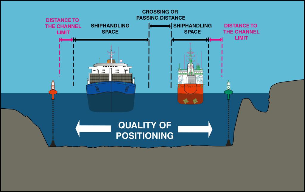
21
22
23 History The MSD was introduced at the Halifax meeting of the working group of the IALA Risk Management Group The MSD covered a significant number of the of the group s concerns The missing elements were collision and grounding probabilities
24 MSD - Purpose Determines minimum safe channel width based on: Vessel size (PIANC) Angle of turn (PIANC) Quality of position from the mix of aids to navigation provided (Marine Aids Study) Channel geophysical conditions (PIANC)
25 How the MSD Works Selecting Vessels

26 Select Aids to Navigation
27 Derive the Effects of Wind and Current
28 Quality of Positioning
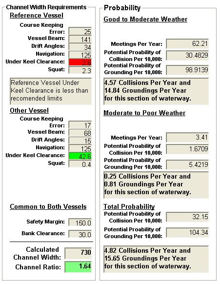
29 MSD - Output A ratio is developed using the MSD minimum channel width and the actual channel width. If the ratio is greater than 1.0 then the channel is considered to be adequate If the ratio is less than 1.0 then the Mariner should proceed with a heightened degree of awareness
30 Development of Probability Formulas Actual vessel track information is gathered A histogram is built based on the track information The distribution of the vessel tracks are then quantified in terms of the Standard Deviation (STD)

31 Fehmarn Belt Westbound

32 Fehmarn Belt Eastbound
33 Histogram for Eastbound Tracks

34 Histogram for Westbound Tracks
35 Moving the MSD Forward Work was started on the inclusion of Dr. Pedersen s formulas A new interface was built and the name was changed to IWRAP Requests for traffic and accident data were also sent out
36 Probability of Collision Probability of collision Pcol = Pc x Na Pc = Causation Factor Constant derived from Dr. Fujii s work Meetings per year (Na) N a 2 QQ u 1 i j 1 ( 2 = L V V B B e i w ( i + j)( i + 2(( ) + j) σ 2 VV i j yr 2 2 2π (#sec/ ) ( σ ) + ( σ ) i j ( ) ) ) 2 σ j Δt
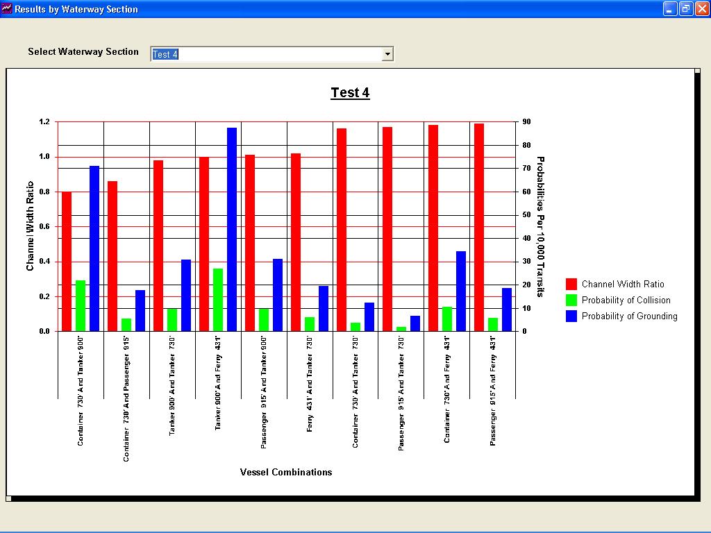
37 Deriving the Standard Deviation Several methods were tried to develop a Floating STD The STD had to change from a Rule of Thumb (X% of channel width) to something that reflected the changes made to the channel. STD = MSD Ratio X Channel Width
38 Floating STD Benefits With the current methodology in place any changes to Aids to Navigation, vessel size, vessel speed, traffic volume, channel width, channel length, wind, and current are reflected instantly.
39 IWRAP Outputs The output is no longer just the channel width ratio, but it also includes: Probability of collision per 10,000 transits Probability of grounding per 10,000 transits Statement that quantifies them into the expected number of occurrences per year.
40 Deviations From Reality IWRAP predicts higher collision rates than what historical data shows. Reasons: Analysis used the boundaries of the of the shipping lane instead of the available channel width IWRAP deals with the interaction of theoretical domains without human intervention
41 Selecting Vessels Vessels must be representative of the population I.e. 730 bulk carrier with 2600 transits and a 950 Cruise ship with 3200 transits. Together they represent X% of total transits in the area. Do not use the worst case vessel to represent the whole population if there is a mix of vessel types and sizes.
42 Initial Results Tampa Bay Historical accident level within the Tampa bay area is relatively low Only three incidents occurred within the boundaries of the shipping lane Largest paring of most capable vessels only represents 45 percent of the traffic in the Tampa area

43 Mullet Key Bend
44 Tampa Bay Mullet Key Bend Case 1 Actual vessel transits 1430 each way 36% of the total annual transits Container 730' + Passenger 915' Probability: 0.37 Collisions Per Year 1.2 Groundings Per Year Channel Width Ratio was 0.69
45 Tampa Bay Mullet Key Bend Case 2 Actual vessel transits 1792 each way 45% of the total annual transits Container 730' + Small Freighter 150' Probability: 0.4 Collisions Per Year 1.31 Groundings Per Year Channel Width Ratio was 1.02
46 Initial Results Bosporus Historical accident level within the Bosporus area is relatively high 15 incidents occurred in one year Largest paring of most capable vessels represents 80 percent of the traffic Worst Case vessels only accounts for 6% of the traffic
47 Naramata Entrance Section 2 Case 1 Actual vessel transits 1500 each way 6% of the total annual transits 1074 Tanker Passenger Probability: 0.1 Collisions Per Year 0.2 Groundings Per Year Channel Width Ratio was 3.33
48 Naramata Entrance Section 2 Case 2 Actual vessel transits 18,800 each way 80% of the total annual transits 347 Container Freighter Probability: 14.1 Collisions Per Year Groundings Per Year Channel Width Ratio was 3.94
49 Copenhagen Meeting Methodologies were discussed to capture Human Element IWRAP now considers the influences of: Four Levels of VTS Pilots onboard vessels Results now have a much tighter correlation between theoretical and reality
50 Initial Conclusions - 1 Minimum channel width by itself is not a sole factor in the determination of the potential risk to navigation in a waterway. Other considerations are: Vessel size and type Traffic density
51 Initial Conclusions - 2 Although total traffic density is a major factor it is more important to consider the sample populations that represent the various configurations of vessels that may transit through a section of waterway. Worst Case vessels cannot be applied to the total population if there is a mix of vessel types and sizes.
52 Initial Conclusions - 3 IWRAP can show the impact of aids to navigation within a channel by rerunning the scenario with different combinations of aid configurations and observing the changes in Pcol and Pground. Given several Aid to Navigation scenarios, one could possibly justify a more expensive option if it was shown to significantly reduce risk.
53 Next Steps IWRAP will be applied to more sections of the Bosporus, Tampa Bay, and the St. Lawrence River. IALA is selecting a new waterway to test IWRAP Enhancements will be made to the existing interface: Automating multi vessel analysis Interface will be multilingual
IALA Recommendation O on the IALA Risk Management Tool For Ports and Restricted Waterways. Edition 1 May 2006
 International Association of Marfine Aids to Navigation and Lighthouse Authorities AISM Association Internationale de Signalisation Maritime IALA IALA Recommendation O - 134 on the IALA Risk Management
World Shipping Council. National Oceanographic and Atmospheric Administration
 Comments of the World Shipping Council Submitted to the National Oceanographic and Atmospheric Administration In the matter of Endangered and Threatened Species; Petition for Rulemaking to Establish a
August April 18,2008 First Revision
 August 15 2011 Slide 01 April 18,2008 First Revision August 15, 2011 Text converted to Tables for ease of formatting instructor guide. Slide 23 Sound Signals Corrected Danger Signal 5 or More Short Blasts
AIS data analysis for vessel behavior during strong currents and during encounters in the Botlek area in the Port of Rotterdam
 International Workshop on Next Generation Nautical Traffic Models 2013, Delft, The Netherlands AIS data analysis for vessel behavior during strong currents and during encounters in the Botlek area in the
Application of the probabilistic-fuzzy method of assessing the risk of a ship manoeuvre in a restricted area
 Application of the probabilistic-fuzzy method of assessing the risk of a ship manoeuvre in a restricted area L. ~ucrna', Z. pietrzykowski2 Maritime University of Szczecin ul. Waly Chrobrego 1/2 70-500
BWS ONLINE FORECASTING BERTH OPERATING SAFETY. Matthew R. O Halloran, Daphne Choong
 BWS ONLINE FORECASTING BERTH OPERATING SAFETY Matthew R. O Halloran, Daphne Choong OMC International Pty Ltd, 2/2 Walmer St, Abbotsford, Vic 3067, Australia matthew@omc-international.com.au daphne@omc-international.com.au
Objective 1: Serious and very serious marine incidents
 Marine Safety Management System (SMS) performance and incident statistics 2017 Review of the Marine Safety Plan objectives (2015-2017) Objective 1: Serious and very serious marine incidents There were
ADANI PORTS & SEZ LTD. ++ MUNDRA PORT ++ GENERAL INFORMATION
 ADANI PORTS & SEZ LTD. ++ MUNDRA PORT ++ GENERAL INFORMATION LOCATION Mundra Port is all weather, independent, commercial port with geographical and hydrological advantages on the West Coast of India,
Delaware River Vessel Reporting System Mariners Advisory Committee For
 Delaware River Vessel Reporting System Mariners Advisory Committee For the Bay and River Delaware The Mariner's Advisory Committee is comprised of Master Mariners, River Pilots, and concerns itself with
MODELING RISK IN THE DYNAMIC ENVIRONMENT OF MARITIME TRANSPORTATION
 Proceedings of the 2001 Winter Simulation Conference B. A. Peters, J. S. Smith, D. J. Medeiros, and M. W. Rohrer, eds. MODELING RISK IN THE DYNAMIC ENVIRONMENT OF MARITIME TRANSPORTATION Jason R. W. Merrick
MICROSCOPIC ROAD SAFETY COMPARISON BETWEEN CANADIAN AND SWEDISH ROUNDABOUT DRIVER BEHAVIOUR
 MICROSCOPIC ROAD SAFETY COMPARISON BETWEEN CANADIAN AND SWEDISH ROUNDABOUT DRIVER BEHAVIOUR Canadian Association of Road Safety Professionals Conference 2017 Paul St-Aubin, Ph.D. 1,2,3, Nicolas Saunier,
VESSEL TRANSIT SCHEDULING AT THE PANAMA CANAL NUMBER AND ORDER OF VESSELS IN THE SCHEDULE
 VESSEL TRANSIT SCHEDULING AT THE PANAMA CANAL This document intends to provide our clients with a better understanding of vessel scheduling in the Panama Canal. For any questions not addressed in this
International regulations and guidelines for maritime spatial planning related to safe distances to multiple offshore structures (e.g.
 International regulations and guidelines for maritime spatial planning related to safe distances to multiple offshore structures (e.g. wind farms) Introduction This is a summary of the most important international
COOPERATIVE VESSEL TRAFFIC SERVICE (CVTS) TAMPA BAY, FLORIDA
 TAMPA BAY, FLORIDA") COOPERATIVE VESSEL TRAFFIC SERVICE (CVTS) TAMPA BAY, FLORIDA USERS MANUAL Oct 2010 1 st Edition Serving the Port of Tampa, Port Manatee, Port of Saint Petersburg, and the Waterways of Tampa Bay 1 Table
COOPERATIVE VESSEL TRAFFIC SERVICE (CVTS) TAMPA BAY, FLORIDA USERS MANUAL Oct 2010 1 st Edition Serving the Port of Tampa, Port Manatee, Port of Saint Petersburg, and the Waterways of Tampa Bay 1 Table
Harbourmaster s Office Operation of Superyacht in the Auckland Region Navigation Safety Operating Requirements
 Harbourmaster s Office Operation of Superyacht in the Auckland Region Navigation Safety Operating Requirements Foreword Maritime Rule 90 requires that every vessel of 500 Gross tonnage or greater carries
A Method Quantitatively Evaluating on Technical Progress of Students in Ship Handling Simulator Training ABSTRACT
 A Method Quantitatively Evaluating on Technical Progress of Students in Ship Handling Simulator Training Kinzo INOUE, Hideo USUI, Rong MA and Cemil YURTOREN Kobe University of Mercantile Marine 5-1-1 Fukae-minami
APPENDIX D. Assessment of Ship Impact Frequencies
 APPENDIX D Assessment of Ship Impact Frequencies WHITE ROSE DEVELOPMENT APPLICATION APPENDIX D ASSESSMENT OF SHIP IMPACT FREQUENCIES SUBMITTED BY: HUSKY OIL OPERATIONS LIMITED AS OPERATOR SUITE 801, SCOTIA
Article. By: Capt. Himadri Lahiry; Prof. Reza Ziarati
 July 2014 marifuture.org Article Reduction of collisions risks at sea. A study of recent casualties through collisions and endeavour to predict the changes required in the use and application of existing
APC Operating Procedures Oil Tankers
 APC Operating Procedures Oil Tankers August 2013 The APC Operating Procedures were developed to aid the Master and Operator of oil tankers in ensuring all aspects of the APC are complied with when transiting
3.9 Marine Transportation
 3.9 Marine Transportation 3. Affected Environment and Environmental Analysis 3.9 Marine Transportation 3.9.1 Introduction This section describes existing marine vessel transportation within the Port, the
ROYAL VANCOUVER YACHT CLUB
 ROYAL VANCOUVER YACHT CLUB PROPOSED EXPANSION PROJECT NAVIGATION CHANNEL DESIGN COAL HARBOUR Prepared for: Royal Vancouver Yacht Club Prepared by: Typlan Consulting Ltd. March 2016 Page 1 of 17 March 23,
Passing Vessel Analysis in Design and Engineering. Eric D. Smith, P.E. Vice President, Moffatt & Nichol
 moffatt & nichol Passing Vessel Analysis in Design and Engineering Eric D. Smith, P.E. Vice President, Moffatt & Nichol Passing Vessel Analysis in Port Engineering and Design Passing Vessel Effects Data
Marine Accident Analysis of Collisions and Groundings: How to learn from past incidents to avoid them in the future
 Marine Accident Analysis of Collisions and Groundings: How to learn from past incidents to avoid them in the future Webinar: International Union of Marine Insurance 10 April 2018 Marine Accident Analysis
Rule 18 - Responsibilities between vessels
 Except where Rules 9, 10 and 13 otherwise require: (a) A power-driven vessel underway shall keep out of the way of: (i) a vessel not under command; (ii) a vessel restricted in her ability to manoeuvre;
Harbourmaster s Office Tamaki River. Navigation Safety Operating Requirements 2014
 Harbourmaster s Office Tamaki River Navigation Safety Operating Requirements 2014 Auckland Council Harbourmaster s Office TAMAKI RIVER Navigation Safety Operating Requirements FOREWARD The purpose of these
World Shipping Council. U.S. Coast Guard. Port Access Route Study: The Atlantic Coast From Maine to Florida
 Comments of the World Shipping Council Submitted to the U.S. Coast Guard In the matter of Port Access Route Study: The Atlantic Coast From Maine to Florida Docket Number: USCG-2011-0351 April 13, 2016
Abstract. 1 Introduction
 Risk assessment study of the mutual interactive influence of working procedures on terminals handling dangerous goods in port of Koper (Slovenia) L. Battelino Water Management Institute, Maritime Engineering
Improving Accuracy of Frequency Estimation of Major Vapor Cloud Explosions for Evaluating Control Room Location through Quantitative Risk Assessment
 Improving Accuracy of Frequency Estimation of Major Vapor Cloud Explosions for Evaluating Control Room Location through Quantitative Risk Assessment Naser Badri 1, Farshad Nourai 2 and Davod Rashtchian
A Study on Local Traffic Management to Improve Marine Traffic Safety in the Istanbul Strait
 THE JOURNAL OF NAVIGATION (2012), 65, 99 112. doi:10.1017/s0373463311000555 The Royal Institute of Navigation A Study on Local Traffic Management to Improve Marine Traffic Safety in the Istanbul Strait
ANNEX 2 RESOLUTION MEPC.124(53) Adopted on 22 July 2005 GUIDELINES FOR BALLAST WATER EXCHANGE (G6) THE MARINE ENVIRONMENT PROTECTION COMMITTEE,
 Adopted on 22 July 2005 GUIDELINES FOR BALLAST WATER EXCHANGE (G6) THE MARINE ENVIRONMENT PROTECTION COMMITTEE,") Page 1 RESOLUTION MEPC.124(53) Adopted on 22 July 2005 GUIDELINES FOR BALLAST WATER EXCHANGE (G6) THE MARINE ENVIRONMENT PROTECTION COMMITTEE, RECALLING Article 38(a) of the Convention on the International
Page 1 RESOLUTION MEPC.124(53) Adopted on 22 July 2005 GUIDELINES FOR BALLAST WATER EXCHANGE (G6) THE MARINE ENVIRONMENT PROTECTION COMMITTEE, RECALLING Article 38(a) of the Convention on the International
GENERAL LIMITATIONS AND RESTRICTIONS. Draft Restrictions
 RULES AND REGULATIONS GOVERNING PILOTS AND PILOTAGE ON THE CORPUS CHRISTI SHIP CHANNEL EFFECTIVE AUGUST 1, 2013 AMENDED EFFECTIVE MAY 13, 2014 AMENDED EFFECTIVE OCTOBER 1, 2014 I GENERAL The Rules and
MAIN REPORT. Assessment of Oil Spill Risk due to Potential Increased Vessel Traffic at Cherry Point, Washington
 MAIN REPORT Assessment of Oil Spill Risk due to Potential Increased Vessel Traffic at Cherry Point, Washington Submitted by VTRA TEAM: Johan Rene van Dorp (GWU), John R. Harrald (GWU), Jason R.. W. Merrick
GENERAL LIMITATIONS AND RESTRICTIONS. LNGC Temporary Exemption (Effective August 21, 2018)
") RULES AND REGULATIONS GOVERNING PILOTS AND PILOTAGE ON THE CORPUS CHRISTI SHIP CHANNEL EFFECTIVE AUGUST 1, 2013 AMENDED EFFECTIVE MAY 13, 2014 AMENDED EFFECTIVE OCTOBER 1, 2014 AMENDED EFFECTIVE JANUARY
RULES AND REGULATIONS GOVERNING PILOTS AND PILOTAGE ON THE CORPUS CHRISTI SHIP CHANNEL EFFECTIVE AUGUST 1, 2013 AMENDED EFFECTIVE MAY 13, 2014 AMENDED EFFECTIVE OCTOBER 1, 2014 AMENDED EFFECTIVE JANUARY
Study Proposal for the Batu Berhenti Light Buoy
 Study Proposal for the Batu Berhenti Light Buoy Malacca Strait Council The 17 th Aids to Navigation Fund Committee meeting 22 23 September 2016, Singapore 1 Contents 1. About Batu Berhanti Light Buoy 2.
WORK-REST REQUIREMENTS FOR PILOTS
 AN ORDER OF THE BOARD OF PILOT COMMISSIONERS FOR THE PORT OF CORPUS CHRISTI AUTHORITY REGARDING WORK-REST REQUIREMENTS FOR PILOTS AND COMBINED BEAM RESTRICTION Whereas, the current Rules and Regulations
Rule Conduct of vessels in restricted visibility
 Section III Rule 19 -- Conduct of vessels in restricted visibility (a) This Rule applies to vessels not in sight of one another when navigating in or near an area of restricted visibility. (b) Every vessel
Relative safety of alternative intersection designs
 Urban Transport XII: Urban Transport and the Environment in the 21st Century 379 Relative safety of alternative intersection designs L. C. Wadhwa 1 & M. Thomson 2 1 James Cook University Townsville Queensland
AMSA A Roadmap Forward & Relevant Alaska Activities. Captain Bob Pawlowski, NOAA (Ret), MNI Legislative Liaison to the Denali Commission
, MNI Legislative Liaison to the Denali Commission") AMSA A Roadmap Forward & Relevant Alaska Activities Captain Bob Pawlowski, NOAA (Ret), MNI Legislative Liaison to the Denali Commission Selected AMSA Key Findings UNCLOS: Fundamental framework IMO: Competent
AMSA A Roadmap Forward & Relevant Alaska Activities Captain Bob Pawlowski, NOAA (Ret), MNI Legislative Liaison to the Denali Commission Selected AMSA Key Findings UNCLOS: Fundamental framework IMO: Competent
The risk assessment of ships manoeuvring on the waterways based on generalised simulation data
 Safety and Security Engineering II 411 The risk assessment of ships manoeuvring on the waterways based on generalised simulation data L. Gucma Maritime University of Szczecin, Poland Abstract This paper
GUIDE TO THE ARCTIC SHIPPING CALCULATION TOOL
 ØRTS HANSEN, GRØNSEDT, LINDSTRØM GRAVERSEN AND HENDRIKSEN GUIDE TO THE ARCTIC SHIPPING CALCULATION TOOL THE NORTHERN SEA ROUTE VS. THE SUEZ CANAL ROUTE CBS MARITIME CROSS DISCIPLINARY PROBLEM-FOCUSED RESEARCH
The analysis of the risk of an accident between a passenger ship and a tanker carrying hazardous substances in the Western Baltic
 Gucma Lucjan Marcjan Krzysztof Przywarty Marcin Maritime University, Szczecin, Poland Journal of Polish Safety and Reliability Association Summer Safety and Reliability Seminars, Volume 5, Number 2, 2014
Navigational risk management with under-keel clearance consideration
 Gucma Lucjan SSARS 2011 Summer Safety and Reliability Seminars, July 03-09, 2011, Gdańsk-Sopot, Poland Schoeneich Marta Maritime University of Szczecin, Poland Navigational risk management with under-keel
PANAMA CANAL AUTHORITY
 OFFICIAL PANAMA CANAL AUTHORITY 1060.0000 CN MW 1/1/98 1/1/01 PILOTAGE General: (1) Pilotage is charged at fees and is subject to the conditions contained in this tariff section. Pilotage services are
Towing Officers' Assessment Record: Western Rivers
 Towing Officers' Assessment Record: Western Rivers NAME: LICENSE NO.: Task No. Considered Proficient Common Element Task or Duty DE's Initials Date A. Vessel Familiarization A.1. X Locate and demonstrate
Nautical Studies to Define Layout Requirements for a New Sea Lock at IJmuiden
 Nautical Studies to Define Layout Requirements for a New Sea Lock at IJmuiden Wim Kortlever, Rijkswaterstaat Freek Verkerk, MARIN photo Flanders Hydraulics Research Smart Ports Seminar April 23, Wageningen
Risk Assessment: Navigation Aids for Shipping in Canso Strait
 Risk Assessment: Navigation Aids for Shipping in Canso Strait Prepared for Transportation Development Centre 800 Rene Levesque Blvd West, 6 th Floor Montreal, Quebec H3B 1X9 prepared by 10352 Arbay Close
Intelligent Decision Making Framework for Ship Collision Avoidance based on COLREGs
 Intelligent Decision Making Framework for Ship Collision Avoidance based on COLREGs Seminar Trondheim June 15th 2017 Nordic Institute of Navigation Norwegian Forum for Autonomous Ships SINTEF Ocean, Trondheim
MARINE SAFETY REGULATION 2016 EXEMPTION ORDER. Clause 140(1)
") MARINE SAFETY REGULATION 2016 EXEMPTION ORDER Clause 140(1) I, Angus Mitchell, Executive Director, NSW Maritime, a delegate of Roads and Maritime Services (RMS), pursuant to clause 140(1) of the Marine
MARINE SAFETY REGULATION 2016 EXEMPTION ORDER Clause 140(1) I, Angus Mitchell, Executive Director, NSW Maritime, a delegate of Roads and Maritime Services (RMS), pursuant to clause 140(1) of the Marine
COAST GUARD ADVISORY NOTICE (CGAN ) To: Distribution Date: September 1, 2017
 To: Distribution Date: September 1, 2017") Commander United States Coast Guard Sector New York 212 Coast Guard Drive Staten Island, NY 10305 Staff Symbol: (spw) Phone: (718) 354-2353 Fax: (718) 354-4190 COAST GUARD ADVISORY NOTICE (CGAN 2017-016)
Commander United States Coast Guard Sector New York 212 Coast Guard Drive Staten Island, NY 10305 Staff Symbol: (spw) Phone: (718) 354-2353 Fax: (718) 354-4190 COAST GUARD ADVISORY NOTICE (CGAN 2017-016)
Safety assessments for Aerodromes (Chapter 3 of the PANS-Aerodromes, 1 st ed)
") Safety assessments for Aerodromes (Chapter 3 of the PANS-Aerodromes, 1 st ed) ICAO MID Seminar on Aerodrome Operational Procedures (PANS-Aerodromes) Cairo, November 2017 Avner Shilo, Technical officer
Safety assessments for Aerodromes (Chapter 3 of the PANS-Aerodromes, 1 st ed) ICAO MID Seminar on Aerodrome Operational Procedures (PANS-Aerodromes) Cairo, November 2017 Avner Shilo, Technical officer
(Refer Slide Time: 00:32)
") Port and Harbour Structures By Prof R. Sundaravadivelu Department of Ocean Engineering, Indian Institute of Technology Madras Module 8, Lecture 43 Detailed Project Report So last class we discussed about
Port and Harbour Structures By Prof R. Sundaravadivelu Department of Ocean Engineering, Indian Institute of Technology Madras Module 8, Lecture 43 Detailed Project Report So last class we discussed about
Maritime Traffic Situations in Bornholmsgat
 http://www.transnav.eu the International Journal on Marine Navigation and Safety of Sea Transportation Volume 9 Number 1 March 2015 DOI: 10.12716/1001.09.01.14 Maritime Traffic Situations in Bornholmsgat
LOWER MISSISSIPPI RIVER PRE-ENTRY INFORMATION
 LOWER MISSISSIPPI RIVER PRE-ENTRY INFORMATION Notice of Arrivals Prior to Arrival at any U.S. port, the vessel master should ensure a complete and accurate Notice of Arrival has been submitted to National
THE SYLLABUS FOR WRITTEN EXAMINATION PILOT'S FOURTH CLASS LICENCE (TEES AND HARTLEPOOL) AND
 AND") PD TEESPORT CONSERVANCY DIVISION HARBOUR MASTER'S OFFICE THE SYLLABUS FOR WRITTEN EXAMINATION IN RESPECT OF A PILOT'S FOURTH CLASS LICENCE (TEES AND HARTLEPOOL) AND PILOTAGE EXEMPTION CERTIFICATE (Issued
PD TEESPORT CONSERVANCY DIVISION HARBOUR MASTER'S OFFICE THE SYLLABUS FOR WRITTEN EXAMINATION IN RESPECT OF A PILOT'S FOURTH CLASS LICENCE (TEES AND HARTLEPOOL) AND PILOTAGE EXEMPTION CERTIFICATE (Issued
IMO RESOLUTION A.960(23) Adopted 5 December 2003 (Agenda item 17)
 Adopted 5 December 2003 (Agenda item 17)") INTERNATIONAL MARITIME ORGANIZATION E IMO ASSEMBLY 23rd session Agenda item 17 A 23/Res.960 5 March 2004 Original: ENGLISH RESOLUTION A.960(23) Adopted 5 December 2003 (Agenda item 17) RECOMMENDATIONS
INTERNATIONAL MARITIME ORGANIZATION E IMO ASSEMBLY 23rd session Agenda item 17 A 23/Res.960 5 March 2004 Original: ENGLISH RESOLUTION A.960(23) Adopted 5 December 2003 (Agenda item 17) RECOMMENDATIONS
HELSINKI COMMISSION HELCOM SAFE NAV 4/2014 Group of Experts on Safety of Navigation Fourth Meeting Helsinki, Finland, 4 February 2014
 HELSINKI COMMISSION HELCOM SAFE NAV 4/2014 Group of Experts on Safety of Navigation Fourth Meeting Helsinki, Finland, 4 February 2014 Agenda Item 3 Accidents and ship traffic in the Baltic Sea Document
Risk-Based Design of Entrance Channel Depths: A Case Study At the Entrance Channel of Mombasa Port, Kenya
 Risk-Based Design of Entrance Channel Depths: A Case Study At the Entrance Channel of Mombasa Port, Kenya Quy N.M., Vrijling J.K., and Pieter van Gelder Delft University of Technology, Delft, the Netherlands
NOTICES TO MARINERS 1 to 46 ANNUAL EDITION 2018
 NOTICES TO MARINERS 1 to 46 CANADIAN COAST GUARD www.notmar.gc.ca Notices to Mariners 1 to 46 Annual Edition 2018 Published under the authority of: Canadian Coast Guard Programs Aids to Navigation and
Underwater noise generated by merchants ships in coastal waters of the Gulf of Gdansk
 Underwater noise generated by merchants ships in coastal waters of the Gulf of Gdansk Karol LISTEWNIK 1 1 Polish Naval Academy, Poland ABSTRACT Currently, there has been a growing interest in monitoring
applied to Port Development and Inland Waterway Transport
 applied to Port Development and Inland Waterway Transport Wytze de Boer March 12, 2018 w.d.boer@marin.nl CHALLINGING WIND AND WAVES applied to port development and inland waterway transport AGENDA 1. Introduction
STOCHASTIC PREDICTION OF MARITIME ACCIDENTS IN THE STRAIT OF ISTANBUL
 STOCHASTIC PREDICTION OF MARITIME ACCIDENTS IN THE STRAIT OF ISTANBUL Emre N. Otay 1 and Şafak Özkan 2 ABSTRACT A physics based mathematical model is developed to simulate the random transit maritime traffic
SIMULATION OF SHIP TO SHORE INTERACTION IN SHALLOW AND NARROW WATERS
 SIMULATION OF SHIP TO SHORE INTERACTION IN SHALLOW AND NARROW WATERS Petru Sergiu ȘERBAN 1 Valeriu Nicolae PANAITESCU 2 1 PhD Student, Department of Navigation and Naval Transport, Mircea cel Bătrân Naval
NAEST(M) training Course Structure and Session Objectives. Day Introduction and enrolment
 training Course Structure and Session Objectives. Day Introduction and enrolment") NAEST(M) training Course Structure and Session Objectives Day 1 0830-0930 Introduction and enrolment 0930-1330 Effective Bridge Procedures & Rule of the Road Lecturer will go through the PowerPoint on
NAEST(M) training Course Structure and Session Objectives Day 1 0830-0930 Introduction and enrolment 0930-1330 Effective Bridge Procedures & Rule of the Road Lecturer will go through the PowerPoint on
Pedestrian traffic flow operations on a platform: observations and comparison with simulation tool SimPed
 Pedestrian traffic flow operations on a platform: observations and comparison with simulation tool SimPed W. Daamen & S. P. Hoogendoorn Department Transport & Planning, Delft University of Technology,
World Shipping Council. Bureau of Ocean Energy Management
 Comments of the World Shipping Council Submitted to the Bureau of Ocean Energy Management In the matter of Potential Commercial Leasing for Wind Power on the Outer Continental Shelf (OCS) Offshore New
MoPac South: Impact on Cesar Chavez Street and the Downtown Network
 MoPac South: Impact on Cesar Chavez Street and the Downtown Network Prepared by: The University of Texas at Austin Center for Transportation Research Prepared for: Central Texas Regional Mobility Authority
Paper 20 Economising mooring and guiding constructions at lock approaches in inland waterways the Dutch experience.
 Paper 20 Economising mooring and guiding constructions at lock approaches in inland waterways the Dutch experience. KOEDIJK, O. C.; MSc Rijkswaterstaat / TU Delft, Rijswijk, Netherlands Email (1 st author):
TICES TO MARINERS 1 TO 46 ANNUAL EDITION 2018 SECTION A AIDS TO NAVIGATION AND MARINE SAFETY
 A5 NAVIGATION SAFETY 10 Routeing of Ships 1 GENERAL 1.1 Rule 10 of the Collision Regulations applies to all ships navigating in or near a routeing system. 1.2 The information on ships' routeing in this
Heterogeneous port traffic of general ships and seaplanes and its simulation
 International Workshop on Next Generation Nautical Traffic Models 2014, Wuhan, China Heterogeneous port traffic of general ships and seaplanes and its simulation Y. Zhou 1, J. Weng 2, Winnie Daamen 3,
Contents. Champaign-Urbana Mass Transit District Stop Placement Guidelines
 Contents Champaign-Urbana Mass Transit District Introduction... 1 Stop Spacing... 2 Rural... 2 Low Density Suburban... 2 General Urban... 2 Urban Core... 2 Operational Safety... 3 Stop Placement... 4 Nearside
New generation of Electronic Card Systems: The 4-D Card
 New generation of Electronic Card Systems: The 4-D Card Capt. Alain Richard Project director Maritime Innovation arichard@imar.ca Context In the present context of globalization and competitiveness, it
Quarterly report of the marine Safety Management System (SMS) performance and incident statistics April Q1 2019
 performance and incident statistics April Q1 2019") Quarterly report of the marine Safety Management System (SMS) performance and incident statistics April 9 - Q 9 Serious and very serious incidents There has been serious incident so far in 9 which is below
Quarterly report of the marine Safety Management System (SMS) performance and incident statistics April 9 - Q 9 Serious and very serious incidents There has been serious incident so far in 9 which is below
ESTIMATION OF THE EFFECT OF AUTONOMOUS EMERGENCY BRAKING SYSTEMS FOR PEDESTRIANS ON REDUCTION IN THE NUMBER OF PEDESTRIAN VICTIMS
 ESTIMATION OF THE EFFECT OF AUTONOMOUS EMERGENCY BRAKING SYSTEMS FOR PEDESTRIANS ON REDUCTION IN THE NUMBER OF PEDESTRIAN VICTIMS Toshiyuki, Yanaoka Yukou, Takahashi Honda R&D Co.,Ltd. Automobile R&D Center
AK-APC-NTV Operating Procedures for Cargo and Passenger Non Tank Vessels Transiting and Operating in Alaska Waters December 26, 2015
 AK-APC-NTV Operating Procedures for Cargo and Passenger Non Tank Vessels Transiting and Operating in Alaska Waters December 26, 2015 The Alternative Planning Criteria (APC) Operating Procedures were developed
Uncontrolled document if printed.
 APPENDIX 3 APPRENTICE PILOT S TRAINING SYLLABUS Issue Date: 16 th March, 2010 Date of Revision: 22nd May, 2013 Revision #2 i THE PURPOSE OF THIS SYLLABUS The purpose of this training syllabus is to ensure
Available online at ScienceDirect. International Journal of e-navigation and Maritime Economy 1 (2014)
") Available online at www.sciencedirect.com ScienceDirect International Journal of e-navigation and Maritime Economy 1 (2014) 29 38 Original article Safety Domain Measurement for Vessels in an Overtaking
Available online at www.sciencedirect.com ScienceDirect International Journal of e-navigation and Maritime Economy 1 (2014) 29 38 Original article Safety Domain Measurement for Vessels in an Overtaking
Abstract. Introduction
 Computer assisted analysis of Aviles Port extension: hydraulic conditions, navigation and training of pilots J.R. Iribarren & J.M. Montero Port Research Program, CEPYC-CEDEX, Antonio Lopez, 81. 28026 Madrid,
Defining Purpose and Need
 Advanced Design Flexibility Pilot Workshop Session 4 Jack Broz, PE, HR Green May 5-6, 2010 Defining Purpose and Need In your agency s project development process, when do design engineers typically get
The LA/LB Harbors handle more than 5,500 commercial vessel arrivals per year (excluding local coastwise and Catalina Island traffic).
.") X. SMALL CRAFT For the purpose of the Los Angeles and Long Beach Harbor Safety Plan, pleasure vessels, commercial fishing vessels and sportfishing boats are designated as small craft. A. BACKGROUND: The
X. SMALL CRAFT For the purpose of the Los Angeles and Long Beach Harbor Safety Plan, pleasure vessels, commercial fishing vessels and sportfishing boats are designated as small craft. A. BACKGROUND: The
Quantitative risk assessment and risk-based decision making
 Norwegian Tunnel Safety Conference 2018 «Connecting Tunnels and Communities» Quantitative risk assessment and risk-based decision making Bernhard KOHL, ILF 18.06.2018 OUTLINE Background Tools for risk-based
Norwegian Coastal Administration (NCA) HSSC November 2015 Busan - Republic of Korea
 HSSC November 2015 Busan - Republic of Korea") Norwegian Coastal Administration (NCA) HSSC7 9-13 November 2015 Busan - Republic of Korea Requirements relating to sector lights for Electronic Navigational Chart (ENC) Product Specifications B E Krosness
Norwegian Coastal Administration (NCA) HSSC7 9-13 November 2015 Busan - Republic of Korea Requirements relating to sector lights for Electronic Navigational Chart (ENC) Product Specifications B E Krosness
CHAPTER I SUEZ CANAL NAVIGATION FEATURES SECTION 1 APPROACHES
 CHAPTER I SUEZ CANAL NAVIGATION FEATURES --------------------- SECTION 1 APPROACHES Art. 8 - PORT SAID: (See Admiralty Charts No. 234, 240 & 241 GENERAL: The Vessels coming from see fifteen miles before
HYDRODYNAMIC INTERACTIONS BETWEEN SHIPS IN NARROW CHANNELS
 TRANSPORT ISSN 1648-414 / eissn 1648-3480 014 Volume 9(): 1 16 doi:10.3846/1648414.014.931886 HYDRODYNAMIC INTERACTIONS BETWEEN SHIPS IN NARROW CHANNELS Vytautas Paulauskas, Donatas Paulauskas, Ričardas
SELECTED ROADWAY CAPACITY ANALYSIS
 CHAPTERFOUR SELECTED ROADWAY CAPACITY ANALYSIS 4.1 SELECTED ROADWAY CAPACITY ANALYSIS Introduction Capacity analysis was performed on six selected roadways within the Dearborn County study area using the
A Novel Approach to Evaluate Pedestrian Safety at Unsignalized Crossings using Trajectory Data
 A Novel Approach to Evaluate Pedestrian Safety at Unsignalized Crossings using Trajectory Data Ting Fu Supervisor: Luis Miranda-Moreno, Nicolas Saunier Ting FU Outline 1. Motivation & Literature Review
Numerical Model to Simulate Drift Trajectories of Large Vessels. Simon Mortensen, HoD Marine DHI Australia
 Numerical Model to Simulate Drift Trajectories of Large Vessels Simon Mortensen, HoD Marine DHI Australia Conceptual framework - multi-layered risk estimation Layer 1 (2011): Ship specific risk (proxy
MITIGATING PIPE AND RISER HYDRAULIC PIPELINE ISSUES WITH THE I-RISER PLUS
 24 TH July 2013 MITIGATING PIPE AND RISER HYDRAULIC PIPELINE ISSUES WITH THE I-RISER PLUS Vern Costelow Business Development Consultant AWMA Water Control Solutions INTRODUCTION Surface irrigation is still
3.9 Marine Transportation
 3.9 Marine Transportation 3. Affected Environment and Environmental Analysis 3.9 Marine Transportation 3.9.1 Introduction This section describes existing marine vessel transportation within the Port, the
FINAL REPORT: VTRA
 Table Contents Publication Information... vii Contact Information... vii PREFACE... 1 EXECUTIVE SUMMARY... 3 Description of Methodology... 4 Base Case and What-If Results... 7 Risk Mitigation and Historical
LOCAL NOTICE TO MARINERS
 USCG Notice to Mariners 3/7/18 (View full Notice here) LNM 10/18 Coast Guard District 1: U.S. Department of Homeland Security United States Coast Guard LOCAL NOTICE TO MARINERS COASTAL WATERS FROM EASTPORT,
STATISTICAL SUMMARY RAILWAY OCCURRENCES 2015
 STATISTICAL SUMMARY RAILWAY OCCURRENCES 215 April 216 Transportation Safety Board of Canada Place du Centre 2 Promenade du Portage, 4th floor Gatineau QC K1A 1K8 819-994-3741 1-8-387-3557 www.tsb.gc.ca
Study of Passing Ship Effects along a Bank by Delft3D-FLOW and XBeach1
 Study of Passing Ship Effects along a Bank by Delft3D-FLOW and XBeach1 Minggui Zhou 1, Dano Roelvink 2,4, Henk Verheij 3,4 and Han Ligteringen 2,3 1 School of Naval Architecture, Ocean and Civil Engineering,
OIL & GAS. MTS DP Committee. Workshop in Singapore Session 4 Day 2. Unwanted Thrust
 OIL & GAS MTS DP Committee Workshop in Singapore 2018 Session 4 Day 2 Unwanted Thrust Unwanted Thrust - Definition Unwanted Thrust Thrust magnitude not what has been ordered by DP (Particularly too high
DET NORSKE VERITAS & ERM - WEST, INC.
 DET NORSKE VERITAS & ERM - WEST, INC. Aleutian Islands Risk Assessment Phase A-Preliminary Risk Assessment Task 2A: Marine Spill Frequency and Size Report Prepared For: National Fish and Wildlife Foundation
TRAFFIC SEPARATION SCHEMES IN THE ADRIATIC SEA
 DRUŠTVO ZA POMORSKO PRAVO SLOVENIJE MARITIME LAW ASSOCIATION OF SLOVENIA EUROPEAN MARITIME DAY 2011 TRAFFIC SEPARATION SCHEMES IN THE ADRIATIC SEA Hrvoje Kačić Paper presented at the round-table EU Maritime
MEMORANDUM. Charlotte Fleetwood, Transportation Planner
 MEMORANDUM Date: Updated August 22, 2017 To: Organization: Charlotte Fleetwood, Transportation Planner Boston Transportation Department From: Jason DeGray, P.E., PTOE, Regional Director of Engineering
Main-McVay Transit Study: Phase 2 Options Definition and High Level Constraints Evaluation
 Main-McVay Transit Study: Phase 2 Options Definition and High Level Constraints Evaluation APRIL 2016 A collaborative study between: For Additional Information or to Comment If you would like additional
WINDING HOLES towards a specification for the ideal turning place
 WINDING HOLES towards a specification for the ideal turning place Introduction The term winding hole is normal in the narrow canal network, and on adjoining broad canals, for a space in which to turn a
Pilotage Directions 2017
 Pilotage Directions 2017 1. Commencement These Pilotage Directions shall come into force on 31 st August 2017 on which date the existing Pilotage Directions are revoked. 2. Short Title These Pilotage Directions
Estimating Potential Safety Benefits for Advanced Vehicle Technologies
 Estimating Potential Safety Benefits for Advanced Vehicle Technologies Mikio Yanagisawa June 8, 2016 The National Transportation Systems Center Advancing transportation innovation for the public good U.S.