Appendix 2: Presentation Library for Inland ECDIS TABLE OF CONTENTS
|
|
|
- Sophie Welch
- 6 years ago
- Views:
Transcription
1 Appendix 2: Presentation Library for Inland ECDIS TABLE OF CONTENTS 1. Lookup Tables Conditional Symbology Procedures Top marks Daymars Restricted areas Lights Bridges Symbols for Inland ECDIS List of symbol names New Symbols to be shown on the chart display Raster symbols Vector symbols (must be rotated, the numbers refer to CEVNI) New symbols to be shown in the "information window on notice marks" Pictures of Inland ECDIS symbols Raster symbols Symbols in general Navigational aids Harbour facilities, terminals Symbols for the "information window on notice marks" Vector symbols Bathymetric inland ENCs
2 1. LOOKUP TABLES The up-to-date Look-up Tables for areas, lines and points are published at 2. CONDITIONAL SYMBOLOGY PROCEDURES 2.1. Top marks The CS (TOPMAR01) of S-52 has to be modified because in this CS it is checked on which structure the top mark is fixed. Since the ENC feature BOYLAT was copied, in the CS the feature boylat has to be added to the list of floating structures. If the top mark is located on a boylat the symbols TOPMA1* have to be drawn according the top shape and colour Daymars A new CS DAYMAR01 has to be introduced. This CS is similar to the CS TOPMAR01 (see clause 2.1) with the exception that there is no need for the distinction of floating and fixed structures, because daymarks exists only for beacons, i.e. fixed structures Restricted areas Since the ENC feature RESARE and the attribute RESTRN were copied the CS (RESARE03) of S-52 has to be modified because in this CS the values of the attribute RESTRN are checked. That means that in the case that RESTRN is not given it has to be checked for the copied attribute restrn instead Lights The CS for LIGHTS (LIGHTS05) of S-52 is affected because in this CS there is a check whether a light is located on a floating object or on a fixed object. The list of floating platforms must be extended by the new feature boylat. To avoid a copy of this CS which would lead to a copy of the official feature LIGHTS, the Inland ECDIS manufacturers have to extend the official CS for LIGHTS as described above Bridges A new CS for bridges has to be introduced to be able to indicate for bridge arches a) the maximum vertical clearance depending on the given beam b) the available space depending on the given beam and air draft The condition for this is the encoding of a bridge arch as it is described in the Encoding Guide. The Inland ECDIS manufacturers have to calculate the vertical clearance of aggregated bridge objects according to the given beam of the ship. 2
3 Maximum available vertical clearance depending on the beam - Increased beam - Same air draft Available space depending on the air draft -> reduced max. vertical clearance -> same available space - Same beam - Increased air draft - Increased beam - Increased air draft -> same max. vertical clearance -> reduced available space -> reduced max. vertical clearance -> reduced / no available space If the vertical clearance of a single bridge object of the aggregation is less than the calculated vertical clearance, this single bridge object must be symbolized by the symbol instruction AC(CHBRN,3);TX('clr %.1f',1,2,3,'14108',1,1,CHBLK,11) If the vertical clearance of a single bridge object of the aggregation is larger or equal than the calculated vertical clearance, this single bridge object must be symbolized by the symbol instruction AC(CHBRN,2) without the indication of the non sufficient vertical clearance. The boundaries of the bridge sequences which are not safe for navigation must be symbolized with the symbol instruction "LS(SOLD,2,DEPSC)". The boundaries of the bridge sequences which are safe for navigation must be symbolized with the symbol instruction "LS(SOLD,1,CHGRD)". The boundaries of the single bridge objects inside a bridge sequence, either safe or not safe for navigation, may not be symbolized. 3
4 2.6. Notice marks A new CS has to be introduced for notice marks. If there are several notice marks at the same point the fnctnm attributes have to be evaluated for the selection of the correct symbol: - if there is at least one notice mark with fnctnm = 1 (prohibition mark), the symbol notmrk04 has to be used; - if there is no prohibition mark, but at least one notice mark with fnctnm = 2 (regulation mark) or fnctnm = 3 (restriction mark), the symbol notmrk05 has to be used; - if there are only notice marks with fnctnm = 4 (recommendation mark) and/or notice marks with fnctnm = 5 (information mark), the symbol notmrk06 has to be used. The symbols NMKREG21, NMKREG22, NMKREG23, NMKREG24, NMKRCD07, NMKRCD08, and NMKINF60 shall only be used if the attribute ORIENT is encoded and only for an optional display of detailed notice mark symbols. If ORIENT is not encoded, the symbols NMKREG02, NMKREG03, NMKREG10, NMKREG11, NMKRCD05, NMKRCD06, and NMKINF38 have to be used M_COVR The CS (DATCVR02) of S-52 has to be modified for the display of bathymetric Inland ENCs. The M_COVR object of the bienc shall be displayed with a blue outline for a clear distinction between areas which are covered by biencs and areas which are not Anchorage areas, depth areas, exceptional navigational structures, shoreline constructions and underwater rocks The CS procedures for - anchorage areas (RESTRN01), - depth areas and exceptional navigational structures (DEPARE02), - shoreline contructions (SLCONS03) and - underwater rocks (OBSTRN07) of S-52 have to be modified to include the display of achare, depare, excnst, slcons and uwtroc. 3. SYMBOLS FOR INLAND ECDIS Symbols can be defined in vector format or in raster format. Symbols which will be rotated must be defined in vector format. The size of vector symbols is adapted 4
5 automatically to the resolution and size of the screen. In case of raster symbols, different symbol sets must be designed to meet the requirements of a readable display. A list of all Inland ECDIS symbols and their pictures is in chapter 4 and 5. The symbols are supplied in digital form at 4. LIST OF SYMBOL NAMES 4.1. New Symbols to be shown on the chart display Raster symbols a) Symbols in general BORDER01: BUNSTA01: BUNSTA02: BUNSTA03: CUSTOM01: DISMAR05: HECMTR01: HECMTR02: HGWTMK01: LIFEBUOY: NOTMRK01: NOTMRK02: NOTMRK03: NOTMRK04: NOTMRK05: NOTMRK06: REFDMP01: SSENTR01: SSLOCK01: check point, border bunker station, diesel oil station bunker station, water bunker station, ballast control point, custom distance mark on river axis hectometre point, 100m hectometre point, 1km high water mark rescue station with life buoy, ring buoy, life ring or life saver notice mark, prohibition notice mark, regulation, restriction notice mark, information, recommendation several notice marks, at least one prohibition mark several notice marks, no prohibition mark, at least one regulation or restriction mark several notice marks, only information and/or recommendation marks refuse dump port entry signal station, lock 5
6 SSWARS01: TRNBSN01: VEHTRF01: VTCLMK01: WTLVGG02: signal station, Wahrschau turning basin vehicle transfer vertical clearance mark at bridges gauge, height of water b) Navigational aids BCNSTK03: BCNLAT23: BOYLAT25: BOYLAT26: BOYLAT27: BOYINL01: BOYINL02: BOYINL03: BOYINL08: TOPMA100: TOPMA101: TOPMA102: TOPMA103: TOPMA104: TOPMA105: TOPMA106: TOPMA107: river beacon, stake pole river beacon, separation - simplified river buoy, fairway separation simplified river buoy, obstruction at the right side river buoy, obstruction at the left side river buoy right-hand side of the fairway (1.B of CEVNI, can be combined with a LIGHTS to 1.A or a TOPMA114 to 1.C or 1.D) river buoy left-hand side of the fairway (2.B of CEVNI, can be combined with a LIGHTS to 2.A or a TOPMA115 to 2.C or 2.D) river buoy bifurcation of the fairway (3.B of CEVNI, can be combined with a LIGHTS to 3.A, a TOPMA117 to 3.C or 3.D, a TOPMA114 to 3.E or 3.F and a TOPMA115 to 3.E1 or 3.F1) river buoy yellow float (8.C of CEVNI) beacon top mark, red cone, point down beacon top mark, red boarded cone, point down beacon top mark, green cone, point up beacon top mark, green boarded cone, point up beacon top mark, red boarded cone, point down, green boarded cone, point up, simplified beacon top mark, red boarded cone, point down, green boarded cone, point up, simplified beacon top mark, white-red square board, vertical beacon top mark, red boarded square board, vertical 6
7 TOPMA108: TOPMA109: TOPMA110: TOPMA111: TOPMA112: TOPMA113: TOPMA114: TOPMA115: TOPMA116: TOPMA117: beacon top mark, white-green square board, diagonal beacon top mark, green boarded square board, diagonal beacon top mark, yellow-black square board, vertical beacon top mark, yellow St. Georg cross beacon top mark, yellow-black square board, diagonal beacon top mark, yellow Andreas-cross buoy top mark, red cylinder buoy top mark, green cone, point up buoy top mark, red-white-red board, entry prohibited buoy top mark, red-green sphere c) Harbour facilities and terminals HRBFAC10: HRBFAC11: HRBFAC12: HRBFAC13: HRBFAC14: HRBFAC15: HRBFAC16: HRBFAC17: HRBFAC18: TERMNL01: TERMNL02: TERMNL03: TERMNL04: TERMNL05: TERMNL06: TERMNL07: TERMNL08: default harbour facility harbour facility naval base harbour facility ship yard harbour facility harbour-master's office harbour facility pilot water police customs office harbour facility service and repair harbour facility quarantine station terminal, passenger terminal terminal, ferry terminal terminal, Container trans-shipment terminal, Bulk trans-shipment terminal, Oil trans-shipment terminal, Fuel trans-shipment terminal, Chemical trans-shipment terminal, Liquid Goods trans-shipment 7
8 TERMNL09: TERMNL10: TERMNL11: TERMNL12: TERMNL13: terminal, Explosive goods trans-shipment terminal, Fish trans-shipment terminal, Car trans-shipment terminal, General Cargo trans-shipment terminal, RoRo Terminal Vector symbols for European inland waterways (must be rotated, the numbers refer to CEVNI) - NMKPRH02: no entry (A.1) - NMKPRH12: no passing on left side (A.10) - NMKPRH13: no passing on right side (A.10) - NMKRCD01: recommended channel in both directions (D.1a) - NMKRCD02: recommended channel only in the direction indicated (D.1b) - NMKRCD03: you are recommended to keep on right side (D.2) - NMKRCD04: you are recommended to keep on left side (D.2) - NMKINF01: entry permitted (E.1) - NMKREG50: wreck pontoon, passage allowed on side showing red-white sign - NMKREG51: wreck pontoon, passage allowed on both sides 4.2. New symbols to be shown in the "information window on notice marks" a) Notice marks for European inland waterways (the numbers refer to CEVNI) - NMKPRH03: sections closed to use, no entry except for non-motorized small craft (A.1.a) - NMKPRH04: no overtaking (A.2) - NMKPRH05: no overtaking of convoys by convoys (A.3) - NMKPRH06: no passing or overtaking (A.4) - NMKPRH07: no berthing (i.e. no anchoring or making fast to the bank) on the side of the waterway on which the sign is placed (A.5) - NMKPRH08: no anchoring or trailing of anchors, cables or chains on the side of the waterway on which the sign is placed (A.6) - NMKPRH09: no making fast to the bank on the side of the waterway on which the sign is placed (A.7) 8
9 - NMKPRH10: no turning (A.8) - NMKPRH11: do not create wash likely to cause damage (A.9) - NMKPRH14: motorized craft prohibited (A.12) - NMKPRH15: sports or pleasure craft prohibited (A.13) - NMKPRH16: water skiing prohibited (A.14) - NMKPRH17: sailing vessels prohibited (A.15) - NMKPRH18: all craft other than motorized vessels or sailing craft prohibited (A.16) - NMKPRH19: use of sail boards prohibited (A.17) - NMKPRH20: water bikes prohibited (A.20) - NMKPRH21: end of zone authorized for high speed navigation of small sport and pleasure craft (A.18) - NMKPRH22: no launching or beaching of vessels (A.19) - NMKREG01: there are restrictions on navigation: make enquiries (with additional sign at bottom of main sign) (C.4) - NMKREG02: proceed in left direction (B.1) - NMKREG03: proceed in right direction (B.1) - NMKREG04: move to the side of the fairway on your port side (B.2a) - NMKREG05: move to the side of the fairway on your starboard side (B.2b) - NMKREG06: keep the side of the fairway on your port side (B.3a) - NMKREG07: keep the side of the fairway on your starboard side (B.3b) - NMKREG08: cross fairway to port (B.4a) - NMKREG09: cross fairway to starboard (B.4b) - NMKREG10: stop as prescribed in the regulations (B.5) - NMKREG11: give a sound signal (B.7) - NMKREG12: keep a particularly sharp outlook (B.8) - NMKREG13: do not enter the main waterway until certain that this will not oblige vessels proceeding on it to change their course or speed (B.9a) 9
10 - NMKREG14: do not cross the main waterway until certain that this will not oblige vessels proceeding on it to change their course or speed (B.9b) - NMKREG15: obligation to enter in a radiotelephone link on the channel as indicated on the board (B.11) - NMKREG16: depth of water limited(c.1) - NMKREG17: headroom limited (C.2) - NMKREG18: width of passage or channel limited (C.3) - NMKREG19: the channel lies at a distance from the left bank (C.5) - NMKREG20: the channel lies at a distance from the right bank (C.5) - NMKREG21: proceed in left direction (B.1), orientation encoded- NMKREG22: proceed in right direction (B.1), orientation encoded - NMKREG23: stop as prescribed in the regulations (B.5), orientation encoded - NMKREG24: give a sound signal (B.7), orientation encoded - NMKRCD05: you are recommended to proceed in the left direction (D.3) - NMKRCD06: you are recommended to proceed in the right direction (D.3) - NMKRCD07: you are recommended to proceed in the left direction (D.3), orientation encoded - NMKRCD08: you are recommended to proceed in the right direction (D.3), orientation encoded - NMKINF02: overhead cable crossing (E.2) - NMKINF03: weir (E.3) - NMKINF04: ferry-boat not moving independently (E.4) - NMKINF05: ferry-boat moving independently (E.4b) - NMKINF06: berthing (i.e. anchoring or making fast to the bank) permitted on the side of the waterway on which the sign is placed (E.5) - NMKINF07: berthing area reserved for pushing navigation vessels that are not required to carry blue lights or blue cones on the side of the waterway on which the sign is placed (E.5.4) - NMKINF08: berthing area reserved for pushing navigation vessels that are required to carry one blue light or one blue cone on the side of the waterway on which the sign is placed (E.5.5) 10
11 - NMKINF09: berthing area reserved for pushing navigation vessels that are required to carry two blue lights or two blue cones on the side of the waterway on which the sign is placed (E.5.6) - NMKINF10: berthing area reserved for pushing navigation vessels that are required to carry three blue lights or three blue cones on the side of the waterway on which the sign is placed (E.5.7) - NMKINF11: berthing area reserved for vessels other than pushing navigation vessels that are not required to carry blue lights or blue cones on the side of the waterway on which the sign is placed (E.5.8) - NMKINF12: berthing area reserved for vessels other than pushing navigation vessels that are required to carry one blue light or one blue cone on the side of the waterway on which the sign is placed (E.5.9) - NMKINF13: berthing area reserved for vessels other than pushing navigation vessels that are required to carry two blue lights or two blue cones on the side of the waterway on which the sign is placed (E.5.10) - NMKINF14: berthing area reserved for vessels other than pushing navigation vessels that are required to carry three blue lights or three blue cones on the side of the waterway on which the sign is placed (E.5.11) - NMKINF15: berthing area reserved for all vessels that are not required to carry blue lights or blue cones on the side of the waterway on which the sign is placed (E.5.12) - NMKINF16: berthing area reserved for all vessels that are required to carry one blue light or one blue cone on the side of the waterway on which the sign is placed (E.5.13) - NMKINF17: berthing area reserved for all vessels that are required to carry two blue lights or two blue cones on the side of the waterway on which the sign is placed (E.5.14) - NMKINF18: berthing area reserved for all vessels that are required to carry three blue lights or three blue cones on the side of the waterway on which the sign is placed (E.5.15) - NMKINF19: anchoring or trailing of anchors, cables or chains permitted on the side of the waterway on which the sign is placed (E.6) - NMKINF20: making fast to the bank permitted on the side of the waterway on which the sign is placed (E.7) - NMKINF21: berthing area reserved for loading and unloading vehicles (E.7.1) - NMKINF22: turning area (E.8) 11
12 - NMKINF23: crossing with secondary waterway ahead (E.9a) - NMKINF24: secondary waterway ahead on the right (E.9.b) - NMKINF25: secondary waterway ahead on the left (E.9.c) - NMKINF26: secondary waterway ahead (main waterway right) - NMKINF27: secondary waterway ahead (main waterway left) - NMKINF28: secondary waterway left (main waterway right) - NMKINF29: secondary waterway right (main waterway left) - NMKINF30: secondary waterway ahead and left (main waterway right) - NMKINF31: secondary waterway ahead and right (main waterway left) - NMKINF32: crossing with main waterway ahead (E.10.a) - NMKINF33: junction with main waterway ahead (E.10.b) - NMKINF34: junction with main waterway ahead and right - NMKINF35: junction with main waterway ahead and left - NMKINF36: junction with main waterway ahead and right (secondary waterway left) - NMKINF37: junction with main waterway ahead and left (secondary waterway right) - NMKINF38: end of prohibition or obligation applying to traffic in one direction only, or end of restriction (E.11) - NMKINF39: drinking water supply(e.13) - NMKINF40: telephone (E.14) - NMKINF41: motorized vessels permitted (E.15) - NMKINF42: sport and pleasure craft permitted (E.16) - NMKINF43: water skiing permitted (E.17) - NMKINF44: sailing vessels permitted (E.18) - NMKINF45: craft other than motorized vessels or sailing craft permitted (E.19) - NMKINF46: use of sailboards permitted (E.20) - NMKINF47: possibility of obtaining nautical information by radio-telephone on the channel indicated (E.23) 12
13 - NMKINF48: water bikes permitted(e.24) - NMKINF49: zone authorized for high speed navigation of small sport and pleasure craft (E.21) - NMKINF50: launching or beaching of vessels permitted (E.22) - NMKINF51-55: maximum number of vessels permitted to berth abreast (E.5.3) - NMKINF56: electrical power supply point (E.25) - NMKINF57: winter harbour (E.26) - NMKINF58: winter shelter (E.27) - NMKINF59: use of spuds permitted (E.6.1) - NMKINF60: end of prohibition or obligation applying to traffic in one direction only, or end of restriction (E.11), orientation encoded b) Notice marks for Russian inland waterways (the numbers refer to GOST ) - NMKPR101: no anchoring or trailing of anchors, cables or chains (1.1) - NMKPR102: no passing or overtaking of convoys (1.2) - NMKPR103: no passing or overtaking (1.3) - NMKPR104: do not create wash (1.4) - NMKPR105: small crafts prohibited (1.5) - NMKRE101: Attention! (keep caution) (2.1) - NMKRE102: fairway crossing (2.2) - NMKRE103: headroom limited (2.4) - NMKIN101: turning area (3.2) - NMKIN102: shipping inspection point (3.3) c) Auxiliary panels (CEVNI Annex 7, Section II) - ADDMRK01: right (triangle to the right) - ADDMRK02: left (triangle to the left) - ADDMRK03: bottom (rectangle, portrait main board) - ADDMRK04: top (rectangle, portrait main board) - ADDMRK05: bottom (rectangle) 13
14 - ADDMRK06: top (rectangle) - ADDMRK07: right (triangle to the right, landscape main board) - ADDMRK08: left (triangle to the left, landscape main board) - ADDMRK09: bottom (triangle to the bottom) - ADDMRK10: bottom (triangle to the bottom, portrait main board) 14
15 5. PICTURES OF INLAND ECDIS SYMBOLS 5.1. Raster symbols Symbols in general BORDER01 BUNSTA01 BUNSTA02 BUNSTA03 CUSTOM01 DISMAR05 HECMTR01 HECMTR02 HGWTMK01 LIFEBUOY01 NOTMRK01 NOTMRK02 NOTMRK03 NOTMRK04 NOTMRK05 NOTMRK06 REFDMP01 SSENTR01 SSLOCK01 SSWARS01 TRNBSN01 VEHTRF01 VTCLMK01 WTLVGG02 15
16 Navigational aids BOYINL01 BOYINL02 BOYINL03 BOYINL08 16

17 Harbour facilities, terminals 17

18 5.2. Symbols for the "information window on notice marks" NMKPR101 NMKPR102 NMKPR103 NMKPR104 NMKPR105 18
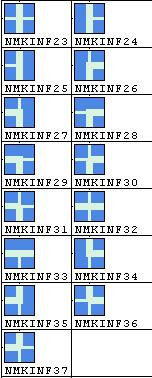
19 NMKREG01 NMKREG02 NMKREG03 NMKREG04 NMKREG05 NMKREG06 NMKREG07 NMKREG08 NMKREG09 NMKREG10 NMKREG11 NMKREG12 NMKREG13 NMKREG14 NMKREG15 NMKREG16 NMKREG17 NMKREG18 NMKREG19 NMKREG20 NMKREG21 NMKREG22 NMKREG23 NMKREG24 NMKRE101 NMKRE102 NMKRE103 NMKRCD05 NMKRCD06 NMKRCD07 NMKRCD08 NMKINF02 NMKINF03 NMKINF04 NMKINF05 NMKINF06 NMKINF07 NMKINF08 NMKINF09 NMKINF10 NMKINF11 NMKINF12 NMKINF13 NMMINF14 NMKINF15 NMKINF16 NMKINF17 NMKINF18 NMKINF19 NMKINF20 NMKINF21 19
20 NMKINF22 NMKINF38 NMKINF39 NMKINF40 NMKINF41 NMKINF42 NMKINF43 NMKINF44 NMKINF45 NMKINF46 NMKINF47 NMKINF48 NMMINF49 NMKINF50 NMKINF51 NMKINF52 NMKINF53 NMKINF54 NMKINF55 NMKINF56 NMKINF57 NMKINF58 NMKINF59 NMKINF60 NMKIN101 NMKIN102 20
21 21
22 22
23 5.3. Vector symbols NMKINF01 NMKPRH02 NMKPRH12 NMKPRH13 NMKRCD01 NMKRCD02 NMKRCD03 NMKRCD04 NMKREG50 NMKREG51 6. BATHYMETRIC INLAND ENCS Bathymetric Inland ENCs must be displayed as complementary layer only. It is not allowed to display biencs if the respective geographic area is not fully covered by an IENC or ENC. The usage of the respective ENCs/IENCs must be within the usage band of the bienc. This means for example a bienc with usage 5 to 7 may not be displayed together with an IENC of usage 4. The bienc has display priority over: depare DEPARE DRGARE DEPCNT SOUNDG UNSARE M_COVR and over the safety contour of the ENC or IENC. The bienc must not have display priority over any other features of the IENC. 23
Presentation Library for Inland ECDIS
 Edition 2.0 1.6.2006 Standard Electronic Chart Display and Information System for Inland Navigation Inland ECDIS for Inland ECDIS In addition to the IHO-S-52 Edition 2.0 IES 20-Section 3 PresLib.doc Page
CHAPTER I SUEZ CANAL NAVIGATION FEATURES SECTION 1 APPROACHES
 CHAPTER I SUEZ CANAL NAVIGATION FEATURES --------------------- SECTION 1 APPROACHES Art. 8 - PORT SAID: (See Admiralty Charts No. 234, 240 & 241 GENERAL: The Vessels coming from see fifteen miles before
Chapter 8. Port hand buoy. Starboard hand buoy. Canadian Aids to Navigation System (CANS) 8.1 Introduction. 8.2 Lateral Buoys
 8.1 Introduction. 8.2 Lateral Buoys") Chapter 8 Canadian Aids to Navigation System (CANS) 8.1 Introduction Various buoys, beacons and signs are known as "Aids to Navigation" or "Navigation Aids". They are devices or systems external to the
Chapter 8 Canadian Aids to Navigation System (CANS) 8.1 Introduction Various buoys, beacons and signs are known as "Aids to Navigation" or "Navigation Aids". They are devices or systems external to the
VISUAL SIGNALS (MARKING) ON VESSELS
 ON VESSELS") Annex 3 VISUAL SIGNALS (MARKING) ON VESSELS I. GENERAL 1.1 The sketches which follow relate to the signals (marking) provided for in the articles of chapter 3 of CEVNI, but not to those provided for in,
Annex 3 VISUAL SIGNALS (MARKING) ON VESSELS I. GENERAL 1.1 The sketches which follow relate to the signals (marking) provided for in the articles of chapter 3 of CEVNI, but not to those provided for in,
Aids to navigation can include buoys, day beacons, range markers, and lighthouses.
 This boating safety course manual has been approved by Transport Canada strictly on the basis that it meets the minimum requirements of basic boating safety knowledge set out in Transport Canada s Boating
Brazilian Complementary River Aids for Inland ENC. IEHG Oct 2008
 Brazilian Complementary River Aids for Inland ENC IEHG Oct 2008 Brazilian Maritime Authority Regulations on Aids to Navigation NORMAM-17 The Hydrography and Navigation Directorate (DHN) has the following
A buoy, for example is an aid to navigation. Aids to navigation include many types of buoys as well as day beacons, range markers, and lighthouses.
 This online study guide has been approved by Transport Canada strictly on the basis that it meets the requirements of the Standard for Pleasure Craft Operator Testing over the Internet (TP 15080E) and
Harbourmaster s Office Tamaki River. Navigation Safety Operating Requirements 2014
 Harbourmaster s Office Tamaki River Navigation Safety Operating Requirements 2014 Auckland Council Harbourmaster s Office TAMAKI RIVER Navigation Safety Operating Requirements FOREWARD The purpose of these
 Page 1 of 6 Nav-Aid Basics Unlike the roads and highways that we drive on, the waterways we go boating on do not have road signs that tell us our location, the route or distance to a destination, or of
RESOLUTION A.817(19) adopted on 23 November 1995 PERFORMANCE STANDARDS FOR ELECTRONIC CHART DISPLAY AND INFORMATION SYSTEMS (ECDIS)
 adopted on 23 November 1995 PERFORMANCE STANDARDS FOR ELECTRONIC CHART DISPLAY AND INFORMATION SYSTEMS (ECDIS)") A 19/Res.817 15 December 1996 Original: ENGLISH ASSEMBLY 19th session Agenda item 10 RESOLUTION A.817(19) adopted on 23 November 1995 PERFORMANCE STANDARDS FOR ELECTRONIC CHART DISPLAY AND INFORMATION
A 19/Res.817 15 December 1996 Original: ENGLISH ASSEMBLY 19th session Agenda item 10 RESOLUTION A.817(19) adopted on 23 November 1995 PERFORMANCE STANDARDS FOR ELECTRONIC CHART DISPLAY AND INFORMATION
IALA Buoyage System and Visual Aids to Navigation. by Aleksandr D. Pipchenko
 IALA Buoyage System and Visual Aids to Navigation by Aleksandr D. Pipchenko IALA buoyage regions chart Which types of marks are provided by the system? Six types of marks provided by the system: Lateral
Chart Features Maritime maps and Admiralty charts have these features:
 Introduction to Charts A chart or map of the area is an important safety item to carry on board. It allows the Master to obtain knowledge of the area to be travelled, and indicates the navigable channels
National Maritime Center
 National Maritime Center Providing Credentials to Mariners Able Seaman Unlimited, Limited, Special, Special OSV, Sail, Fishing Industry (Sample Examination) Page 1 of 17 Choose the best answer to the following
Oil Tanker - VLCC. Yosu Inward Transit Monitoring (Entering into the Port of Yosu on a Loaded VLCC) LEG 1: APPROACHING ANCHORAGE AND PILOT STATION
 LEG 1: APPROACHING ANCHORAGE AND PILOT STATION") Yosu Inward Transit Monitoring (Entering into the Port of Yosu on a Loaded VLCC) Vessel VLCC Date 11/05/2016 Draft Fwd 21.0 D Draft Midship 21.0 Draft Aft 21.0 Max Allowed arrival draft by the port: 21.0
Yosu Inward Transit Monitoring (Entering into the Port of Yosu on a Loaded VLCC) Vessel VLCC Date 11/05/2016 Draft Fwd 21.0 D Draft Midship 21.0 Draft Aft 21.0 Max Allowed arrival draft by the port: 21.0
WELCOME TO THE. Pleasure Craft Operator Training (PCOC)
") WELCOME TO THE Pleasure Craft Operator Training (PCOC) REGULATIONS The Competency of Operators of Pleasure Craft Regulations require operators of pleasure craft fitted with a motor and used for recreational
WELCOME TO THE Pleasure Craft Operator Training (PCOC) REGULATIONS The Competency of Operators of Pleasure Craft Regulations require operators of pleasure craft fitted with a motor and used for recreational
Rules Practice Exam 5
 1 BOTH INTERNATIONAL & INLAND Vessel "A" (towing) and vessel "B" are meeting as shown. In this situation, which statement is TRUE? Diagram 12 A. Both vessels should alter course to starboard and pass port
Rules Practice Exam 9
 1 BOTH INTERNATIONAL & INLAND If your vessel is underway in fog and you hear one prolonged and three short blasts, this is a. A. vessel not under command B. sailing vessel C. vessel being towed (manned)
National Maritime Center
 National Maritime Center Providing Credentials to Mariners (Sample Examination) Page 1 of 19 Choose the best answer to the following multiple choice questions. NO reference materials are authorized for
PERFORMANCE STANDARDS FOR ELECTRONIC CHART DISPLAY AND INFORMATION SYSTEMS (ECDIS) [IMO Resolutions A.817 (19), MSC.64 (67) and MSC.
 [IMO Resolutions A.817 (19), MSC.64 (67) and MSC.") 1 PERFORMANCE STANDARDS FOR ELECTRONIC CHART DISPLAY AND INFORMATION SYSTEMS (ECDIS) [IMO Resolutions A.817 (19), MSC.64 (67) and MSC.86 (70)] (amended March 1999) Note: The IMO Performance Standards for
1 PERFORMANCE STANDARDS FOR ELECTRONIC CHART DISPLAY AND INFORMATION SYSTEMS (ECDIS) [IMO Resolutions A.817 (19), MSC.64 (67) and MSC.86 (70)] (amended March 1999) Note: The IMO Performance Standards for
CHAPTER 8 BUOYAGE 8.1 GENERAL
 145 CHAPTER 8 BUOYAGE 8.1 GENERAL The term `buoyage encompasses all floating structure such as buoys or beacons which are used to orientate mariners and to mark the edges of navigable channels and fairways.
V Complying with IHO S-52/S-63/S-64
 Model FEA-2107/2807 V.06.50 Complying with IHO S-52/S-63/S-64 The software has been upgraded to V.06.50 in accordance with the IHO standards. IHO S-52 Ed. 6.1.1 Specifications for Chart Contents and Display
Port of Port Elizabeth Information
 LOCATION Latitude 34º 01 S Longitude 25º 42 E PILOTAGE Pilotage is compulsory. Rendezvous point is 2.2 nautical miles NE of the port entrance on the leading lights. Pilot transfer is by pilot boat, unless
National Maritime Center
 National Maritime Center Providing Credentials to Mariners Q301 Rules of the Road-Inland (Sample Examination) Page 1 of 19 Choose the best answer to the following Multiple Choice Questions. NO reference
Implementation of CEVNI Rev 5. Reinhard Vorderwinkler Austria
 Implementation of CEVNI Rev 5 Reinhard Vorderwinkler Austria SC.3 and SC.3/WP.3 History ITC 1956 sub-committee (SC) on IWT for preparation of international conventions in IWT renamed: principal working
THEORY PRACTICE PAPER /
 THEORY PRACTICE PAPER http://www.uspowerboating.com / http://www.boatsafe.com http://www.singaporetests.com NAUTICAL TERMS 1. What does the term "draught of the vessel" mean :- a. depth of the vessel below
SECTION XI - COAST PILOT UPDATING. 1. To acquire a general knowledge of the responsibilities of the Auxiliary in COAST PILOT UPDATING activities.
 SECTION XI - COAST PILOT UPDATING INTRODUCTION: The United States Coast Pilot published by the NOS-C&GS, is a series of volumes that supplement the navigational data shown on nautical charts. Sources for
National Maritime Center
 National Maritime Center Providing Credentials to Mariners (Sample Examination) Page 1 of 12 Choose the best answer to the following Multiple Choice Questions. 1. An alternating light. (A) shows a light
SS&S Chapter 8 Instructor Guide
 SS&S Chapter 8 Instructor Guide The Rules of the Nautical Road The PowerPoints (PPT) slides for this SS&S chapter were copied from the BS&S-13 th Ed PPT because they are identical. Only the chapter numbers
REGION B ONLY. Figure Figure Figure Figure Figure Figure Figure Figure 10.60
 221 REGION B ONLY 10.5 LATERAL MARKS 10.5.1 Description of Lateral marks Port hand marks Shape: pillar buoy (Figures 10.53 and 10.54), can lighted buoy (Figures 10.55 and 10.56) or not lighted (Figures
Rules Practice Exam 7
 1 INTERNATIONAL ONLY The light which may be used with a vessel's whistle is to be. A. used when the whistle is broken B. used prior to sounding the whistle C. used only at night D. a white light 2 INTERNATIONAL
You must stop your. pass with caution on the port side of vessel "B" The vessel moving upstream against the current
 BK NUM ANS QUESTION ANSWER A ANSWER B ANSWER C ANSWER D ILLUST 1 1 C 1 2 B INLAND ONLY You are navigating in a narrow channel and must remain in the channel for safe operation. Another vessel is crossing
National Maritime Center
 National Maritime Center Providing Credentials to Mariners (Sample Examination) Page 1 of 16 Choose the best answer to the following Multiple Choice Questions. 1. On U.S. charts, you can tell if a named
Rule 18 - Responsibilities between vessels
 Except where Rules 9, 10 and 13 otherwise require: (a) A power-driven vessel underway shall keep out of the way of: (i) a vessel not under command; (ii) a vessel restricted in her ability to manoeuvre;
THE SYLLABUS FOR WRITTEN EXAMINATION PILOT'S FOURTH CLASS LICENCE (TEES AND HARTLEPOOL) AND
 AND") PD TEESPORT CONSERVANCY DIVISION HARBOUR MASTER'S OFFICE THE SYLLABUS FOR WRITTEN EXAMINATION IN RESPECT OF A PILOT'S FOURTH CLASS LICENCE (TEES AND HARTLEPOOL) AND PILOTAGE EXEMPTION CERTIFICATE (Issued
PD TEESPORT CONSERVANCY DIVISION HARBOUR MASTER'S OFFICE THE SYLLABUS FOR WRITTEN EXAMINATION IN RESPECT OF A PILOT'S FOURTH CLASS LICENCE (TEES AND HARTLEPOOL) AND PILOTAGE EXEMPTION CERTIFICATE (Issued
LIST OF NOTICES TO MARINERS 2017 PAC 201 JUAN DE FUCA STRAIT AND STRAIT OF GEORGIA, FIRST EDITION, 2012
 1 Chapter 1 After paragraph 154 Insert: 154.1 Pacific Gateway Marina (250-412-5509) is located west of the community wharf. Moorage, gas, diesel, a launching ramp and deep water berths for sailboats are
AHO s experience on HD bathymetric ENCs
 AHO s experience on HD bathymetric ENCs ENCWG3 Wollongong 16 18 April 2018 Alvaro Sanchez DD Charting Quality Assurance, Standards and Specifications Australian Hydrographic Office Background 2016 As part
Pilotage Directions 2017
 Pilotage Directions 2017 1. Commencement These Pilotage Directions shall come into force on 31 st August 2017 on which date the existing Pilotage Directions are revoked. 2. Short Title These Pilotage Directions
Rules Practice Exam 12
 1 INLAND ONLY You are on vessel "A", and vessel "B" desires to overtake you on your starboard side as shown. After the vessels have exchanged one blast signals, you should. Diagram 31 A. alter course to
NavRule Practice Exam, 70 Series Practice April 24, Labeled F (I received a reply from the testing service that all these answers were
 1. INTERNATIONAL & INLAND An all-round flashing yellow light may be exhibited by a(n)? a. vessel laying cable b. vessel towing a submerged object c. vessel not under command d. air cushion vessel 2. INTERNATIONAL
Rules Practice Exam 11
 1 BOTH INTERNATIONAL & INLAND While underway in fog, you hear a vessel sound one prolonged blast followed by two short blasts on the whistle. What does this signal indicate? A. A vessel towing B. A vessel
2005 ABC. Chapter 3 Part 2. Navigating with ATON's. Revision to D-13 Local Notes. Instructor Notes for Mike Brough. Mike Brough
 2005 ABC Chapter 3 Part 2 Navigating with ATON's Revision to D-13 Local Notes Instructor Notes for Mike Brough Mike Brough June 24 2008 June 24 2008 Slide 1 June 24 2008 New graphics Navigating on Water
TICES TO MARINERS 1 TO 46 ANNUAL EDITION 2018 SECTION A AIDS TO NAVIGATION AND MARINE SAFETY
 A5 NAVIGATION SAFETY 10 Routeing of Ships 1 GENERAL 1.1 Rule 10 of the Collision Regulations applies to all ships navigating in or near a routeing system. 1.2 The information on ships' routeing in this
Harbourmaster s Office Operation of Superyacht in the Auckland Region Navigation Safety Operating Requirements
 Harbourmaster s Office Operation of Superyacht in the Auckland Region Navigation Safety Operating Requirements Foreword Maritime Rule 90 requires that every vessel of 500 Gross tonnage or greater carries
Norwegian Coastal Administration (NCA) HSSC November 2015 Busan - Republic of Korea
 HSSC November 2015 Busan - Republic of Korea") Norwegian Coastal Administration (NCA) HSSC7 9-13 November 2015 Busan - Republic of Korea Requirements relating to sector lights for Electronic Navigational Chart (ENC) Product Specifications B E Krosness
Norwegian Coastal Administration (NCA) HSSC7 9-13 November 2015 Busan - Republic of Korea Requirements relating to sector lights for Electronic Navigational Chart (ENC) Product Specifications B E Krosness
SAFETY OF NAVIGATION OPERATING ANOMALIES IDENTIFIED WITHIN ECDIS
 E 4 ALBERT EMBANKMENT LONDON SE1 7SR Telephone: +44 (0)20 7735 7611 Fax: +44 (0)20 7587 3210 SN.1/Circ.312 9 July 2012 SAFETY OF NAVIGATION OPERATING ANOMALIES IDENTIFIED WITHIN ECDIS 1 The Sub-Committee
LIST OF CORRECTIONS. 14 / July /052(T) - 07/125(T) - 08/136(T) - 08/137(T) - 12/177(T) - 15/212(T) - 18/232-22/285(T)
 - 07/125(T) - 08/136(T) - 08/137(T) - 12/177(T) - 15/212(T) - 18/232-22/285(T)") LIST OF CORRECTIONS 105 Chart Kanaal van Gent naar Terneuzen Edition 2016 Updated up to and including NMs 14 / 2018 05 July 2018 The last version of these corrections are available on www.vlaamsehydrografie.be
LIST OF CORRECTIONS 105 Chart Kanaal van Gent naar Terneuzen Edition 2016 Updated up to and including NMs 14 / 2018 05 July 2018 The last version of these corrections are available on www.vlaamsehydrografie.be
NOTICE TO MARINERS. No 03 of Port of Southampton Precautionary Area (Thorn Channel)
") NOTICE TO MARINERS No 03 of 2016 (Update and Re-Issue of Notice to Mariners No 03 of 2014) Port of Southampton Precautionary Area (Thorn Channel) 1 NOTICE IS HEREBY GIVEN that all vessels navigating within
NOTICE TO MARINERS No 03 of 2016 (Update and Re-Issue of Notice to Mariners No 03 of 2014) Port of Southampton Precautionary Area (Thorn Channel) 1 NOTICE IS HEREBY GIVEN that all vessels navigating within
SAILING INSTRUCTIONS BILLY RUN. Saturday 28 April The organising authority (OA) is the South of Perth Yacht Club
 is the South of Perth Yacht Club") SAILING INSTRUCTIONS BILLY RUN Saturday 28 April 2018 The organising authority (OA) is the South of Perth Yacht Club 1. RULES 1.1. The regatta will be governed by the rules as defined in The Racing Rules
SAILING INSTRUCTIONS BILLY RUN Saturday 28 April 2018 The organising authority (OA) is the South of Perth Yacht Club 1. RULES 1.1. The regatta will be governed by the rules as defined in The Racing Rules
Towing Officers' Assessment Record: Near Coastal/Oceans
 Towing Officers' Assessment Record: Near Coastal/Oceans NAME: LICENSE NO.: Task No. Considered Proficient Common Element Task or Duty DE's Initials Date A. Vessel Familiarization A.1. X Locate and demonstrate
ADANI PORTS & SEZ LTD. ++ MUNDRA PORT ++ GENERAL INFORMATION
 ADANI PORTS & SEZ LTD. ++ MUNDRA PORT ++ GENERAL INFORMATION LOCATION Mundra Port is all weather, independent, commercial port with geographical and hydrological advantages on the West Coast of India,
Towing Officers' Assessment Record: Western Rivers
 Towing Officers' Assessment Record: Western Rivers NAME: LICENSE NO.: Task No. Considered Proficient Common Element Task or Duty DE's Initials Date A. Vessel Familiarization A.1. X Locate and demonstrate
Minimum requirements. for Inland ECDIS devices in information mode and comparable chart display devices. for using Inland AIS data on board
 Protocol 2014-I-12, annex 2 Central Commission for the Navigation of the Rhine (CCNR) Minimum requirements and recommendations for Inland ECDIS devices and comparable chart display devices Minimum requirements
Towing Officers' Assessment Record: Great Lakes/Inland
 Towing Officers' Assessment Record: Great Lakes/Inland NAME: LICENSE NO.: Task No. Considered Proficient Common Element Task or Duty DE's Initials Date A. Vessel Familiarization A.1. Locate and demonstrate
The addition of information about Transport Canada s Navigation Protection Program.
 Notice of Amendment Port Information Guide Date issued: September 8, 2017 Date effective: October 8, 2017 Introduction This notice of amendment is posted publicly to notify industry, stakeholders and the
EMPA 2017 How can the S-102 Bathymetric Surface Product improve safety in navigation and pilotage?
 EMPA 2017 How can the S-102 Bathymetric Surface Product improve safety in navigation and pilotage? Operated by the Norwegian Mapping Authority, Hydrographic Service FREEDOM TO CHOOSE Content What is the
U.S. Aids To Navigation System Brochure U.S. Coast Guard, Office of Aids to Navigation (202) ,
 ,") AIDS TO NAVIGATION Learning Objectives: As a result of this session the participant should: Understand the principal buoyage systems in the United States. Become aware of the characteristics of the buoy
AIDS TO NAVIGATION Learning Objectives: As a result of this session the participant should: Understand the principal buoyage systems in the United States. Become aware of the characteristics of the buoy
Rules Practice Exam 14
 1 BOTH INTERNATIONAL & INLAND Additional light signals are provided in the Annexes to the Rules for vessels. A. engaged in fishing B. not under command C. engaged in towing D. under sail 2 BOTH INTERNATIONAL
SAILING INSTRUCTIONS. Port of Los Angeles Harbor Cup Cal Maritime Invitational Intercollegiate Regatta March 9 th -11 th, RULES
 SAILING INSTRUCTIONS Port of Los Angeles Harbor Cup Cal Maritime Invitational Intercollegiate Regatta March 9 th -11 th, 2018 1 RULES 1.1 The regatta will be governed by the ICSA Procedural Rules (PR),
Delaware River Vessel Reporting System Mariners Advisory Committee For
 Delaware River Vessel Reporting System Mariners Advisory Committee For the Bay and River Delaware The Mariner's Advisory Committee is comprised of Master Mariners, River Pilots, and concerns itself with
ANNEX 24 RESOLUTION MSC.232(82) (adopted on 5 December 2006)
 (adopted on 5 December 2006)") RESOLUTION MSC.232(82) (adopted on 5 December 2006) ADOPTION OF THE REVISED PERFORMANCE STANDARDS FOR ELECTRONIC CHART DISPLAY AND INFORMATION SYSTEMS (ECDIS) THE MARITIME SAFETY COMMITTEE, RECALLING Article
RESOLUTION MSC.232(82) (adopted on 5 December 2006) ADOPTION OF THE REVISED PERFORMANCE STANDARDS FOR ELECTRONIC CHART DISPLAY AND INFORMATION SYSTEMS (ECDIS) THE MARITIME SAFETY COMMITTEE, RECALLING Article
Anchoring Is Important
 BCC Sailing Classes - Third Theory Anchoring Anchoring Is Important 1 The Anchor is your last resort. Anchoring Keep off a lee shore. Needs to be shaped (type of anchor) to bury in the type of bottom for
Overview Vessel Types on the Danube
 Overview Vessel Types on the Danube 1. Introduction This document describes the most important vessel types for Danube IWT. In the first part of the document, various vessel types and their load capacities
PORT INFO GENERAL BERTH INFO
 s ervices SHIPWRIGHT WWW.SHIPWRIGHTSERVICES.CO.ZA 9 DE DUINE CLOSE, BLUEWATERBAY, SALDANHA, 7395, WESTERN CAPE, SOUTH AFRICA TEL. +27 71 040 6022 EMAIL. DERICK@SHIPWRIGHTSERVICES.CO.ZA PORT INFO GENERAL
NavRule Practice Exam, 70 Series Practice April 18, Labeled C have been copied to collection
 1C. INTERNATIONAL & INLAND There are two classes of vessel which, to the extent necessary to carry out their work, do not have to comply with the rule regarding traffic separation schemes. One of these
LOCAL NOTICE TO MARINERS
 USCG Notice to Mariners 3/7/18 (View full Notice here) LNM 10/18 Coast Guard District 1: U.S. Department of Homeland Security United States Coast Guard LOCAL NOTICE TO MARINERS COASTAL WATERS FROM EASTPORT,
SEMI FINAL EXAMINATION
 SEMI FINAL EXAMINATION 1. Which vessel may exhibit, if practicable, the lights for sailing vessels, but if she does not, she shall have ready at hand a electric torch or lighted lantern showing a white
SECTION I NM 25/16 CHART CORRECTIONS
 CHART CORRECTIONS 12221 82Ed. 2/14 LAST NM 23/16 25/16 12224 26Ed. 8/14 LAST NM 23/16 25/16 12225 60Ed. 11/11 LAST NM 23/16 25/16 Delete Light PC 37 43 36 N 75 48 35 W Change Light to 8R Fl R 4s 15ft 4M
NOTICES TO MARINERS 1 to 46 ANNUAL EDITION 2018
 NOTICES TO MARINERS 1 to 46 CANADIAN COAST GUARD www.notmar.gc.ca Notices to Mariners 1 to 46 Annual Edition 2018 Published under the authority of: Canadian Coast Guard Programs Aids to Navigation and
When answering a question, when in doubt, pick answer that considers safety first. Navigation Aids
 Appendix A Boat Course Review When answering a question, when in doubt, pick answer that considers safety first. Navigation Aids Port hand lateral buoy Starboard hand lateral buoy (red right returning)
6 th CSPCWG MEETING Monaco, December Paper for Consideration by CSPCWG
 CSPCWG6-08.2A 6 th CSPCWG MEETING Monaco, 01-03 December 2009 Paper for Consideration by CSPCWG Fouls and Foul Ground Submitted by: Australia (Jeff Wootton) Executive Summary: Depiction of fouls and foul
SIGNI Signs and Signals on Inland Waterways
 ECONOMIC COMMISSION FOR EUROPE INLAND TRANSPORT COMMITTEE Working Party on Inland Water Transport SIGNI Signs and Signals on Inland Waterways Revision 1 Amendment UNITED NATIONS New York and Geneva, 2010
LES CAHIERS D APPRENTISSAGE MARITIME AIDS TO NAVIGATION AIDS TO NAVIGATION IALA MARITIME BUOYAGE SYSTEM. Page 1 sur 22
 IALA MARITIME BUOYAGE SYSTEM LES CAHIERS D APPRENTISSAGE MARITIME Page 1 sur 22 GENERAL PRINCIPLES OF THE SYSTEM The responsibility for safe navigation resides with the mariner, through the appropriate
TIDE TABLES FOR WARRENPOINT PORT (CARLINGFORD LOUGH) All times in GREENWICH MEANTIME HEIGHTS REFER TO CHART DATUM Chart Datum is mts.
 All times in GREENWICH MEANTIME HEIGHTS REFER TO CHART DATUM Chart Datum is mts.") TIDE TABLES FOR WARRENPOINT PORT (CARLINGFORD LOUGH) 2019 Times and Heights of High and Low Waters. All times in GREENWICH MEANTIME HEIGHTS REFER TO CHART DATUM Chart Datum is -3.05 mts. OD Belfast Tide
TIDE TABLES FOR WARRENPOINT PORT (CARLINGFORD LOUGH) 2019 Times and Heights of High and Low Waters. All times in GREENWICH MEANTIME HEIGHTS REFER TO CHART DATUM Chart Datum is -3.05 mts. OD Belfast Tide
Registered at Russia Ministry of Justice dated June 25, 2013 N Registration No
 -------------------------------------------------- ----------------------------------- Russian Federation Ministry of Transport Order dated May 29, 2013 N 190 On Approval of Compulsory Regulations at Sea
BookletChart. Intracoastal Waterway Matecumbe to Grassy Key NOAA Chart A reduced-scale NOAA nautical chart for small boaters
 BookletChart Intracoastal Waterway Matecumbe to Grassy Key NOAA Chart 11449 A reduced-scale NOAA nautical chart for small boaters When possible, use the full-size NOAA chart for navigation. Published by
National Maritime Center
 National Maritime Center Providing Credentials to Mariners (Sample Examination) Page 1 of 8 Choose the best answer to the following Multiple Choice Questions. 1. Assume that your vessel has just entered
Standard Marine Navigational Vocabulary
 DEPARTMENT OF TRANSPORT MERCHANT SHIPPING NOTICE NO. M. 1252 Standard Marine Navigational Vocabulary Notice to Owners, Masters, Officers and Seamen of Merchant Ships, Yachts and other Sea-going Vessels.
On Approval of Compulsory Regulations at Sea Port Kavkaz
 Registered at Russia Ministry of Justice dated June 25, 2013 N 28887 -------------------------------------------------- ----------------------------------- Russian Federation Ministry of Transport Order
Convention on the International Regulations for Preventing Collisions at Sea, 1972 (COLREGs) EXPLANATORY NOTES
 EXPLANATORY NOTES") Convention on the International Regulations for Preventing Collisions at Sea, 1972 (COLREGs) EXPLANATORY NOTES Adoption: 20 October 1972 Entry into force: 15 July 1977 Introduction Amendment procedure
Convention on the International Regulations for Preventing Collisions at Sea, 1972 (COLREGs) EXPLANATORY NOTES Adoption: 20 October 1972 Entry into force: 15 July 1977 Introduction Amendment procedure
Paper for consideration by ENC Working Group. Use of AU6 ENC cells as an option for Bathymetric ENCs (benc)
") Paper for consideration by ENC Working Group Use of AU6 ENC cells as an option for Bathymetric ENCs (benc) Submitted by: Alvaro Sanchez (AHS) Executive Summary: Compilation of high density bathymetric
Paper for consideration by ENC Working Group Use of AU6 ENC cells as an option for Bathymetric ENCs (benc) Submitted by: Alvaro Sanchez (AHS) Executive Summary: Compilation of high density bathymetric
2 Boating Rules and Regulations... 73
 Contents at a Glance Chapter 1 Boat Design and Construction Chapter 2 Boating Rules and Regulations Chapter 3 Navigation Rules (ColRegs) Chapter 4 Boat Operating and Seamanship Chapter 5 Piloting and Navigation
This direction contains the requirements for the compulsory pilotage areas within the Auckland region. This
 Harbourmaster s Direction 2-15 Pilotage Foreword This direction contains the requirements for the compulsory pilotage areas within the Auckland region. This direction updates and supersedes previous Harbourmaster
SECTION II NM 26/10 NAVIGATION PUBLICATIONS ALMANACS CORRECTIONS
 NAVIGATION PUBLICATIONS ALMANACS CORRECTIONS NAUTICAL ALMANAC Ed 2011 NEW EDITION (NGA) 26/10 SAILING DIRECTIONS CORRECTIONS PUB 140 8 Ed 2010 NEW EDITION (NGA) 26/10 COAST PILOT CORRECTIONS COAST PILOT
Tees & Hartlepool Pilotage Co. Ltd. Effective from 1 st January Pilotage Charges. Tees and Hartlepool Pilotage District
 Tees & Hartlepool Pilotage Co. Ltd Effective from 1 st January 2013 Pilotage Charges Pursuant to Section 10 of the Pilotage Act 1987, PD Teesport Limited (PDT) hereby approves the following list of pilotage
properly applied assessment in the use.1 landmarks.1 approved in-service of ECDIS is not experience The primary method of fixing required for those
 STCW Code Table A-II/3 Specification of minimum standard of for officers in charge of a navigational watch and for masters on ships of less than 500 gross tonnage engaged on near-coastal voyages Ref: https://www.edumaritime.net/stcw-code
Solent Pilotage Introduction Summary of Pilotage Requirements VTS Other References
 Solent Pilotage Introduction Welcome to Solent Pilotage. The Solent is one of the busiest waterways in Europe with a mix of commercial, recreational and military traffic. It is also a complex tapestry
Thames Passage From Brentford to Teddington
 Thames Passage From Brentford to Teddington Introduction: The Thames Ring route uses a tidal section of the river Thames between Brentford and Teddington that requires extra preparation and skill. We hope
Royal Temple Yacht Club Notice of Race & Sailing Instructions 2019
 Royal Temple Yacht Club Notice of Race & Sailing Instructions 2019 The organising authority for each day of racing will be The Royal Temple Yacht Club Notice of Race for IRC and Cruiser Handicap classes
ROUTEING MEASURES OTHER THAN TRAFFIC SEPARATION SCHEMES
 E 4 ALBERT EMBANKMENT LONDON SE1 7SR Telephone: +44 (0)20 7735 7611 Fax: +44 (0)20 7587 3210 SN.1/Circ.317 4 December 2012 ROUTEING MEASURES OTHER THAN TRAFFIC SEPARATION SCHEMES 1 The Maritime Safety
WESTHAVEN TRIPLE SERIES SAILING INSTRUCTIONS
 WESTHAVEN TRIPLE SERIES 12 th November 2016 22 nd April 2017 The Organising Authorities are the Royal New Zealand Yacht Squadron (RNZYS) Ponsonby Cruising Club (PCC) & Richmond Yacht Club (RYC) SAILING
All comments received will be taken into consideration before the proposed amendments are implemented.
 Notice of Amendment Port Information Guide Notification date: February 13 th, 2018 Preamble In accordance with the Canada Marine Act, 1998, Section 57 Notice, the Vancouver Fraser Port Authority is proposing
HELSINKI COMMISSION HELCOM SAFE NAV 4/2014 Group of Experts on Safety of Navigation Fourth Meeting Helsinki, Finland, 4 February 2014
 HELSINKI COMMISSION HELCOM SAFE NAV 4/2014 Group of Experts on Safety of Navigation Fourth Meeting Helsinki, Finland, 4 February 2014 Agenda Item 3 Accidents and ship traffic in the Baltic Sea Document
Visiting Lake Macquarie
 Visiting Lake Macquarie Lake Macquarie is the largest coastal salt water lake in Australia and is a prime boating destination for both small and large vessels. Many sailing regattas and fishing activities
Forth Ports Limited. Ruling Depths & Under Keel Clearances
 Forth Ports Limited - Forth Vessels are scheduled into / out of ports on the Forth & Tay in accordance with the under keel clearance criteria specified in this section of the Marine Guidelines & Port Information.
PILOTAGE DIRECTIONS REVIEWED DECEMBER 2016
 PILOTAGE DIRECTIONS REVIEWED DECEMBER 2016 REVISION LIST Revision No. Date Details Approved by: Original All sections 12 Dec 2013 First edition of C W Brand v1.0 Pilotage Directions Revision 2 all sections
NAUTICAL TERMINOLOGY
 It s important to have a basic understanding of common nautical terms associated with the parts, positions and directions of your vessel. Knowing these terms will make it easier to communicate with people
S Current Outline draft TSMAD C /11/2013 TR
 3.0.0 Current Outline draft TSMAD27-4.9.1C 0.14 04/11/2013 TR 1.0 Introduction Table of Contents 1.1 Change Control History 1.2 Introduction 1.3 Acknowledgements 1.4 Acronyms and Terms 1.5 Normative References
Translation from Estonian version, approved by Villu Vatsfeld, CEO of Saarte Liinid Ltd., on 23 th of March 2018 KUIVASTU PORT RULES
 Translation from Estonian version, approved by Villu Vatsfeld, CEO of Saarte Liinid Ltd., on 23 th of March 2018 KUIVASTU PORT RULES 1. GENERAL PART 3 1.1. Type of commercial undertaking of the port authority
ELAN YACHTS COMMODORES CUP SERIES
 ELAN YACHTS COMMODORES CUP SERIES 11 th November 2017 7 th April 2018 The Organising Authority is the Royal New Zealand Yacht Squadron 181 Westhaven Drive, Westhaven, Auckland 1011 PO Box 46182 Herne Bay,
LIST OF CORRECTIONS. 02 / January /052(T) - 07/125(T) - 08/136(T) - 08/137(T) - 12/177(T) - 15/212(T) - 18/232-22/285(T)
 - 07/125(T) - 08/136(T) - 08/137(T) - 12/177(T) - 15/212(T) - 18/232-22/285(T)") LIST OF CORRECTIONS 105 Chart Kanaal van Gent naar Terneuzen Edition 2016 Updated up to and including NMs 02 / 2018 18 January 2018 The last version of these corrections are available on www.vlaamsehydrografie.be
LIST OF CORRECTIONS 105 Chart Kanaal van Gent naar Terneuzen Edition 2016 Updated up to and including NMs 02 / 2018 18 January 2018 The last version of these corrections are available on www.vlaamsehydrografie.be