Pilot Rating Exam Meteorology
|
|
|
- Rebecca Jones
- 6 years ago
- Views:
Transcription
, Nigel Page and Pat Dower")
1 Pilot Rating Exam Meteorology Derived from material originally assembled by Kenny Eaton (Dunstable Hang-Gliding and Paragliding Club), Nigel Page and Pat Dower (DSC)
2 The 3 levels of understanding Will it be a nice day? Will it be a flyable day? Will it be a good day for XC flying?
3 The 3 levels of understanding Will it be a nice day? Will it be a flyable day? Will it be a good day for XC flying? and Will I pass my pilot exam!?
4 For the Pilot Exam, you should: understand the relationship between wind direction and areas of high and low pressure be able to describe in detail a cold front and a warm front (typical clouds, conditions, pressure changes, wind changes). be able to identify some common high, medium and low cloud types, know their approximate heights and fully understand convection (the birth and development of a thermal, through to plotting the progress of a thermal given the ELR, dewpoint and initial temperature). understand, and be able to define and use, meteorological terms such as stability, instability, veer, back, ELR, DALR, SALR, tephigram, anabatic, katabatic.
5 be able to describe the usual conditions associated with high and low pressure weather systems understand the causes of: valley winds throughout the day, anabatic and katabatic flow, sea breezes and seabreeze fronts, wave lift and fog (of various types). fully understand and be able to interpret a synoptic chart - to the extent of being able to describe the current weather at selected locations, and to forecast likely changes. be able to link cloud types to precipitation.
6 Fundamentals: Gas Laws For an idealised 'parcel' of gas, there are fixed relationships between temperature, pressure and volume: Pressure is proportional to temperature: P T Pressure is inversely proportional to volume: P 1/V
7 Funamentals: Insolation Air is almost transparent and not heated significantly by the sun s rays. The sun heats the surface of the earth. Air in contact with the surface is heated by conduction and expands Warm air near the surface of the earth rises by convection and mixes with cooler air higher up

8 World Air Circulation The Earths greatest heating takes place at the Equator. This causes the air to rise and in turn to draw in new air to replace that which has risen. This rising air cools to the temperature of its surroundings. Stops rising and spreads out North and South for about 30 Degrees of Latitude.
9 World Air Circulation Similar circulation occurs in bands between 30 and 60 in the Northern and Southern Hemispheres (Ferrel cells) as well as in the Polar regions (Polar cells).

10 Coriolis Effect If the Earth did not rotate air would flow along straight lines and air pressure differences would quickly equalise. The rotation of the Earth causes the Coriolis effect. Any freely moving object or fluid appears to turn right from the direction of motion in the Northern Hemisphere and to the left in the Southern Hemisphere

11 Coriolis Effect Air wants to flow directly toward areas of low pressure but the Coriolis effect deflects the air, to the right in the Northern Hemisphere and to the left in the Southern.
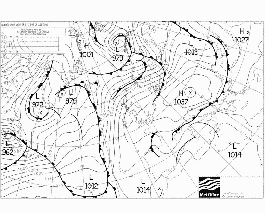
12 Coriolis Effect This means that away from the equator, an equilibrium is established with circular flows, anti-clockwise in the Northern Hemisphere around low pressures and and clockwise in the Southern Hemisphere. Air flows around high pressure systems in the opposite direction.
13 Pressure Systems Units millibars (mb) or hectopascals(hpa) These are equivalent, 1mb = 1hPa. ICAO - International Civil Aviation Authority Standard Pressure mb / hpa 30 feet change in height 1 mb / hpa change in pressure Cyclone (Depression) = Low Pressure System Anti-Cyclone = High Pressure System
14 Pressure Systems Isobar = A line of constant pressure Geostrophic Wind - Flow approximately in line with isobars Airmass = A large body of air within which horizontal changes in pressure and temperature are small
15 Pressure Systems Buys-Ballot s Law In the northern hemisphere if you stand with your back to the wind the low pressure will be on your left.
16 Low Pressure Systems Ascending Air Anti-Clockwise Flow Below 1500 feet friction pulls the wind in towards the low Wind direction moves to the right as you ascend
17 High Pressure Systems Descending Air Clockwise Flow Below 1500 feet friction pushes the wind away from the high Wind direction moves to the right as you ascend
18 Pressure Systems Low Pressure: Usually poor weather. Associated frontal systems can bring rain and cloud High Pressure: (Summer) Light Winds and Less Cloud. Can lead to Inversions High Pressure: (Winter) Fog and Low Cloud or Clear Skies
19
20 Synoptic chart features Cyclones, anticyclones, isobars Isobars link equal pressures Pressures shown in Millibars Closely spaced isobars mean strong wind, widely spaced, light winds Wind directions use Buys-Ballot's Law
21 Wind Direction Changes Veering - wind changes direction Clockwise, or if facing the wind, blows more from your right Backing - wind changes direction Anti-Clockwise, or blows more from the left
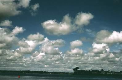
22 How do clouds form? For a particular pressure and temperature, a certain amount of water vapour may be present in the air. Higher temperatures allow the air to contain more water vapour (think steam!) Lower temperatures allow less water vapour Clouds form when air which is saturated with water vapour (i.e. it is at dew point temperature) is further cooled causing condensation.
23
24
25
26
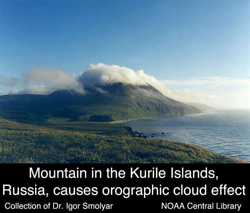
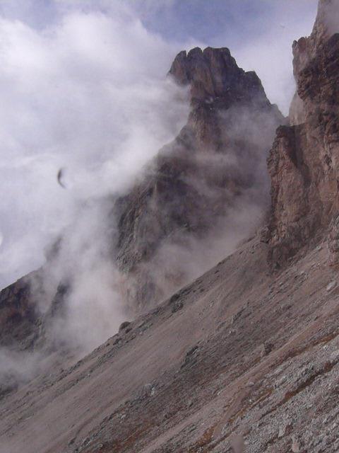
27 Clouds - Formation Convection. The action of the sun heats the ground. This in turn heats air close to the ground which becomes warmer and less dense. It may rise and as it does so, it will cool. Eventually it may cool to the dew point making its water vapour condense to form cloud, particularly Cumulus. Orographic uplift. When moving air is forced to rise by an obstruction such as a mountain chain, it will cool. If it cools below its dew point, water vapour condenses to form orographic cloud on the windward side of the obstruction.
28
29
30
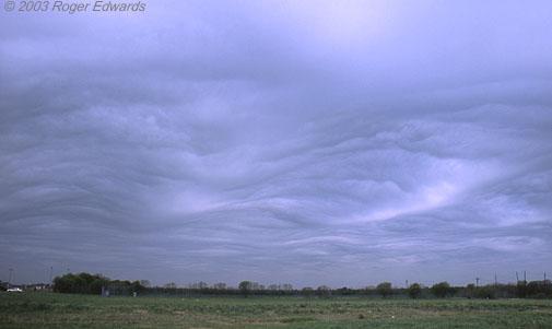
31 Clouds - Formation Widespread lifting When two airmasses meet, as in a frontal system, large areas of cold air may flow under the warmer air, forcing it to rise and thereby producing large areas of cloud. Turbulence and mixing e.g at wind sheers

32
33
34
35
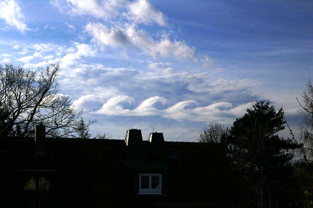
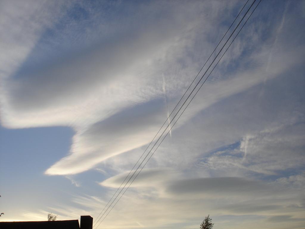
36 Clouds - Formation Lenticular Lens shaped clouds indicate the presence of wave activity. They form where the wave is at its highest point and can stack. Wave Health Warning
37
38

39
40

41 Clouds - Types
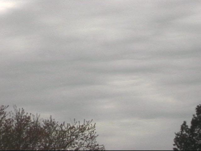
42 Clouds - Types High: 15k ->40k ft Mid. (Alto): 6k ->23k ft Low: 0 -> 8k ft Stratus : Layered Cumulus : Heaps Cirrus : Hair-Like Nimbus : Raining

43 Fronts C A B
44 Fronts
45 Warm Front An area of warm air catches up with an area of cold air and overrides it (due to the lower density). Shallow slope (1:50 to 1:400) with the air rising gradually over many hundreds of miles. Gradually thickening layer of cloud eventually producing steady rain near the frontal zone. Slow Moving

46 Warm Front The frontal zone effect may extend 600 miles ahead of the frontal transition. High cloud such as Cirrus and Cirro stratus will shut off the solar activity Cloudbase will lower with Altostratus and Nimbostratus giving drizzle as the front nears. Rain may begin up to 5-10 hrs before the passage of the front. The winds may strengthen and back. At the front, the rain eases off, the wind will veer 50 or so and the temperature and humidity will rise. We are now in the warm sector.
47 Cold Front An area of colder air undercuts warmer air Steeper slope (1:10 to 1:100) with strong updraughts being produced May have rapid development of heavy showers Fast Moving ( 20mph)

48 Cold Front The frontal zone effect may extend 100 miles ahead of the front itself. At the front, the temperature drops and the wind veers, often to the North West direction. Cumulus and CumuloNimbus may develop, with heavy rain. Behind the cold front, there is often a complete clearance of cloud but this very quickly gives way to high Cumulus.

49 Occluded Front As the depression deepens the cold front, with its weather systems, catches up with the warm front and the two types of weather become mixed. Occlusions have some of the characteristics of a warm front or a cold front, but on a milder scale. The weather produced by an occlusion can range from that of the two frontal types to prolonged periods of rain.
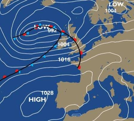
50 Fronts A front is a boundary between 2 different airmasses (commonly found in depressions) Cold Front The leading edge of an advancing cold air mass. Appears on a synoptic chart as a blue line with triangles where the front contacts the ground. The direction in which the triangles point is the direction in which the front is moving. Warm Front The leading edge of an advancing warm air mass. On a synoptic chart appears as a red line with semi-circles where the front contacts the ground. The direction in which the semi-circles point is the direction in which the front is moving. Occlusion (or occluded front) Occlusions form when the cold front of a depression catches up with the warm front, lifting the warm air between the fronts into a narrow wedge above the surface. On a synoptic chart appears as a purple line with a combination of triangles and semi-circles. Troughs Fronts describe thermal characteristics and areas where there is significant precipitation. However, precipitation is not confined to fronts. Drizzle in warm sectors or showers in cold air occur fairly randomly, but occasionally, lines of more organized precipitation can develop. These are called troughs.

51 Sea Breeze - Sea Breeze Front Land warms up quickly but the sea remains at much the same temperature. Thermal heating of the air over the land results in low pressure and lifting with sea air flowing in to replace the lifting air. Sea breezes sometimes move many miles inland shutting off thermals near the coast.

52 Mountains and Valleys - (Anabatic Flow) Wind flow is upslope Tend to develop in hilly or mountainous areas during the daytime, especially if the weather is relatively calm with some sunshine. Valley flow is uphill
53

54 Mountains and Valleys (Katabatic Flow) Wind flow is downslope Develop once ground heating has finished Valley flow is downhill Magic Lift
 Polar Continental (Pm) Polar Maritime (Am) Arctic Maritime (rpm) Returning Polar")
55 Air Masses There are 6 main Air Masses in the UK (Tc) Tropical Continental (Tm) Tropical Maritime (Pc) Polar Continental (Pm) Polar Maritime (Am) Arctic Maritime (rpm) Returning Polar Maritime
56 Air Masses Tropical Continental (Warm and Dry) Originates over North Africa. This air mass rarely reaches the UK, needing continuous S or SE winds to do so. Typically: Light S Winds, Warm Dry Air, Visibility affected Tropical Maritime (Warm and Moist) Travels great distances over water. Originates from a warm source near the Azores and the West Indies. As the air mass moves NE it becomes cooler and more stable. Typically: SW Winds, Layered Clouds, Warm and Humid Air Some Precipitation and the chance of sea fog
57 Air Masses Polar Continental (Cold and Dry) Originates over Eastern Europe and travels west bringing cold winds. The air mass becomes less stable as it crosses the North Sea and is warmed from below. Typically: E Winds, Large amounts of Cloud, Very Cold Air Polar Maritime (Cold and Moist) Originates in the Arctic or Greenland area and travels SE over the Atlantic. Due to the air mass moving to warmer latitudes the lower levels are warmed over the sea causing it to become unstable. Typically: SW to N Winds, Heaped (Cumuliform) Clouds, Good Visibility, Cold Air
58 Air Masses Arctic Maritime (Cold) Similar to Polar Maritime except that it has had a shorter journey from the source region. (These days often weather bomb or rather a Polar jet ). Typically: N Winds, Heaped Clouds, Good Visibility, Cold Air Heavy and frequent precipitation (often as snow) Returning Polar Maritime (Moist) Air is forced south of the 50 North Latitude by a slow moving depression to the West of the UK. It swings NE and travels up the country. Warmed lower layers, cold aloft. Typically: SW Winds, Layered Medium Level Clouds Good visibility, instability and showers.
59 Thermal Growth and Activity Cloudbase (ft) = (Air temp - dew point) x 400 (approx.) Dew Point = Temperature at which moisture condenses out of the air (Dew Point is often more or less the minimum overnight temperature at ground level) Lapse Rate = A change in temperature with height Adiabatic = No heat energy is gained or lost by an airmass Dew Point lapse rate = 0.5 C / 1000ft (below cloudbase)
60 Thermal Growth and Activity Environmental lapse rate (ELR) averages 2 C/1000ft Dry adiabatic lapse rate (DALR) = 3 C / 1000ft Saturated adiabatic lapse rate (SALR) 1.5 C/1000ft Inversion = Area of the atmosphere where temp rises with height Isothermal = Area of the atmosphere where temp is stable with height Stable = ELR < DALR Unstable = ELR > DALR
61 Thermal Growth and Activity
62 Example of Thermal Growth and Activity A thermal leaves the ground with a temperature of 25 C At 5,000ft the thermal has cooled to 10 C and reached equilibrium with the surrounding air and stops rising.
63 Thermal Growth and Activity On the day shown, clouds have formed with the cloudbase at dew point and the cloud tops limited by an inversion above. Note that if the dew point had been lower, or the thermal broke away at a lower temperature then the thermal would have risen as a blue thermal (no cloud). The SALR has a steeper gradient, encouraging lifting above cloudbase.
64 Forecasts (online) Charts & Satpics Met Office Synoptics BBC RASP rasp.inn.leedsmet.ac.uk Satpics en.sat24.com/en/gb Medium Range (click through to medium range) Live Conditions Wendy XCWeather Everything

65 Example Satellite image

66 Example Medium Range Forecast
67 Conditions / Forecasts Radio : Radio 4 Shipping forecasts. Radio : Volmet (VHF airband voice service) CAVOK : (Ceiling and Visibility OK ) Visibility 10km or more, no cloud below 5000ft above aerodrome elevation and no cumulonimbus cloud at any level. No significant weather at or in the vicinity of the aerodrome METARs Live conditions Xcweather Wendy windblows, other online weather stations.
68 Further Reading Pilot Exam Notes Thermal Flying : Burkhard Martens Meteorology & Flight : Tom Bradbury Meteorology for Glider Pilots: CE Wallington Understanding Flying Weather : D Piggott Instant Weather Forecasting : Alan Watts Air Riders Weather : Alan Watts Understanding the Sky : Dennis Pagen Pilot Handbook : BHPA
PILOT EXAM NOTES METEOROLOGY
 Page 1 of 27 PILOT EXAM NOTES METEOROLOGY GT/ Peak Soaring Association Feb 97 Page 2 of 27 Contents: 1. BUYS BALLOTS S LAW... 4 2. FRONTS... 4 2.1 WARM FRONT... 5 2.1.1 Cross section... 5 2.2 WARM SECTOR...
CHAPTER 9. More on meteorology
 CHAPTER 9 More on meteorology 1). Atmospheric Pressure Atmospheric pressure is the pressure with which the atmosphere acts downwards due to its weight. Pressure decreases with altitude because the column
APPI PPG LECTURE 5: FURTHER METEOROLOGY
 LECTURE 5: FURTHER METEOROLOGY Introduction: This lecture covers Further Meteorology and aims to give you more of an understanding of advanced weather conditions and patterns. However Meteorology is a
Envs, Geol, Phys 112: Global Climate. Energy-Atmosphere System Review Aguado & Bert, Ch. 1, 2, 3, 4, 5, 6, 9, 10
 Exam 1 Review Energy-Atmosphere System Review Aguado & Bert, Ch. 1, 2, 3, 4, 5, 6, 9, 10 Location on Earth (L04) Latitude & Longitude great circles, prime meridian, time zones, cardinal points, azimuth
Understanding Weather
 Understanding Weather Images Graphic of the atmosphere. Enlarge Cirrus clouds. Enlarge Air masses Air masses are parcels of air that bring distinctive weather features to the country. An air mass is a
WEATHER SYSTEMS OF MIDDLE LATITUDES
 CHAPTER 10 WEATHER SYSTEMS OF MIDDLE LATITUDES MULTIPLE CHOICE QUESTIONS 1. In equal volumes, which one of the following air masses exerts the highest surface air pressure? a. cp *b. A c. mp d. ct e. mt
Wind is caused by differences in air pressure created by changes in temperature and water vapor content.
 Topic 8: Weather Notes, Continued Workbook Chapter 8 Wind is caused by differences in air pressure created by changes in temperature and water vapor content. Wind blows from high pressure areas to low
Weather and Meteorology Sheet 1 Adiabatic Processes The definition is:- A system where heat is neither added nor taken from a process.
 Weather and Meteorology Sheet 1 Adiabatic Processes The definition is:- A system where heat is neither added nor taken from a process. The expansion and compression of gases are adiabatic. Consider the
Heart of England Offshore Cruising Association HOEOCA
 Sailing Weather Penny Tranter 19 January 2017 Heart of England Offshore Cruising Association HOEOCA Weather and climate The difference between weather and climate? Weather is the state of the atmosphere
Moisture and Stability in the Atmosphere
 Moisture and Stability in the Atmosphere Humidity can be measured as: HUMIDITY Absolute humidity the mass of water vapour in a volume of air (g/m 3.) Relative Humidity the proportion of the actual mass
18 Flight Hazards over High Ground
 18 Flight Hazards over High Ground meteorology 18.1 Mountain Effect on Fronts When a warm front passes a mountain range, the air, is lifted over the mountain and will strengthen the formation of cloud
ATMOSPHERIC CIRCULATION. WIND = The horizontal movement of air. Results from the differences in air pressure. Always moves from HIGH to LOW.
 ATMOSPHERIC CIRCULATION WIND = The horizontal movement of air. Results from the differences in air pressure. Always moves from HIGH to LOW. Pressure differences result from variations in temperature. AIR
DIRECCION DE PERSONAL AERONAUTICO DPTO. DE INSTRUCCION PREGUNTAS Y OPCIONES POR TEMA
 MT DIREION DE PERSONL ERONUTIO DPTO. DE INSTRUION PREGUNTS Y OPIONES POR TEM 1 TEM: 0643 OM-RT - Weather - hap. 6 OD_PREG: PREG20098600 (5301) PREGUNT: Every physical process of weather is accompanied
Chapter 8 Air Masses
 Chapter 8 Air Masses Air Masses - 1 1. An Air Mass is a large body of air usually about 1500 km across and several km thick, that has homogeneous physical properties. 2. The important physical properties
PHSC 3033: Meteorology Stability
 PHSC 3033: Meteorology Stability Equilibrium and Stability Equilibrium s 2 States: Stable Unstable Perturbed from its initial state, an object can either tend to return to equilibrium (A. stable) or deviate
NATS 101, Section 4, Spring 2009 Midterm Examination #2 March 13, 2009
 EXAM NUMBER NATS 101, Section 4, Spring 2009 Midterm Examination #2 March 13, 2009 Name: SID: S Instructions: Write your name and student ID on ALL pages of the exam. In the multiple-choice/fill in the
Meteorology I Pre test for the Second Examination
 Meteorology I Pre test for the Second Examination MULTIPLE CHOICE 1. A primary reason why land areas warm up more rapidly than water areas is that a) on land, all solar energy is absorbed in a shallow
Adiabatic Lapse Rates and Atmospheric Stability
 8 Adiabatic Lapse Rates and Atmospheric Stability Learning Goals After studying this chapter, students should be able to: 1. describe adiabatic processes as they apply to the atmosphere (p. 174); 2. apply
Length of day for a full year. Ocean Gyres. Wet. Adiabatic. lapse rate, starts at. dewpoint Dry Adiabatic lapse rate
 Vernal Equinox March 20, 11:57 AM, CDT Sun will rise exactly in the east and set exactly in the west. All latitudes get 12 hours of day and 12 hours of dark. Length of day for a full year Wet Adiabatic
ENVIRONMENTAL PHYSICS
 ENVIRONMENTAL PHYSICS Atmospheric Stability An understanding of why and how air moves in the atmosphere is fundamental to the prediction of weather and climate. What happens to air as it moves up and down
Air Pressure and Wind
 Air Pressure and Wind 19.1 Understanding Air Pressure Air Pressure Defined Air pressure is the pressure exerted by the weight of air. Air pressure is exerted in all directions down, up, and sideways. The
Cloud Development and Forms
 Chapter 6 Lecture Understanding Weather and Climate Seventh Edition Cloud Development and Forms Redina L. Herman Western Illinois University Mechanisms That Lift Air When air lifts, clouds develop and
AT350 EXAM #2 November 18, 2003
 AT350 EXAM #2 November 18, 2003 Name and ID: Enter your name and student ID number on the answer sheet and on this exam. Record your answers to the 50 questions by using a No. 2 pencil to completely fill
What most affects a seaman s (and your) life? The Weather.?
 life? The Weather.?") What most affects a seaman s (and your) life? The Weather.? 1 Never go to sea without a weather forecast On land TV National radio Local radio Newspaper Teletext Web Mobile phone Barometer At sea BBC radio
What most affects a seaman s (and your) life? The Weather.? 1 Never go to sea without a weather forecast On land TV National radio Local radio Newspaper Teletext Web Mobile phone Barometer At sea BBC radio
MET 200 Lecture 11 Local Winds. Last Lecture: Forces. Review of Forces. Balance of Forces
 MET 200 Lecture 11 Local Winds Last Lecture: Forces Scales of Motion Eddies Sea Breeze Mountain-Valley Circulations Chinook - Snow Eater Drainage Wind - Katabatic Wind 1 2 Review of Forces 1. Pressure
Chapter. Air Pressure and Wind
 Chapter Air Pressure and Wind 19.1 Understanding Air Pressure Air Pressure Defined Air pressure is the pressure exerted by the weight of air. 19.1 Understanding Air Pressure Air Pressure Defined Air pressure
LAB H - ATMOSPHERE AND CLIMATE LAB II STABILITY AND PRECIPITATION PATTERNS
 Introduction LAB H - ATMOSPHERE AND CLIMATE LAB II STABILITY AND PRECIPITATION PATTERNS This lab will provide students with the opportunity to become familiar with the concepts of atmospheric stability
Small- and large-scale circulation
 The Earth System - Atmosphere II Small- and large-scale circulation Atmospheric Circulation 1. Global atmospheric circulation can be thought of as a series of deep rivers that encircle the planet. 2. Imbedded
Civil Air Patrol Auxiliary of the United States Air Force
 Mountain Flying Qualification Course Civil Air Patrol Auxiliary of the United States Air Force Mountain Weather Slopes Most U.S. mountain ranges are oriented north-south, while the prevailing winds are
Physics 137 Exam 2 Review
 Physics 137 Exam 2 Review Chapter 4: Humidity, Condensation, and Clouds 1. Evaporation and Condensation 2. Saturation (Equilibrium) a. rate at which water evaporates from the liquid (ice) surface is the
Nevis Hulme Gairloch High School John Smith Invergordon Academy. Gairloch High School / Invergordon Academy
 Nevis Hulme Gairloch High School John Smith Invergordon Academy 1 Gairloch High School / Invergordon Academy ATMOSPHERIC CIRCULATION The Three Cell Model Global Winds The ITCZ The purpose of this presentation
Vertical Motion and Atmospheric Stability
 Lesson 4 Vertical Motion and Atmospheric Stability This lesson describes the vertical structure of the atmosphere, atmospheric stability and the corresponding vertical motion. Adiabatic diagrams are introduced
18.1 Understanding Air Pressure 18.1 Understanding Air Pressure Air Pressure Defined Measuring Air Pressure Air pressure barometer
 18.1 Understanding Air Pressure 18.1 Understanding Air Pressure Air Pressure Defined Air pressure is the pressure exerted by the weight of air. Air pressure is exerted in all directions down, up, and sideways.
Weather and Climate. Climate the situation of the atmosphere during a long period of time and a big surface.
 Weather and Climate Weather and Climate Weather the situation of the atmosphere during a short period of time and a small surface of the Earth. It is very irregular and changes a lot. Climate the situation
ATS 351 Lecture 6. Air Parcel. Air Parcel Movement: Why does rising air expand and cool? Stability & Skew-T Diagrams
 ATS 351 Lecture 6 Stability & Skew-T Diagrams To demonstrate stability, a parcel of air is used Expands and contracts freely Always has uniform properties throughout Air Parcel Air Parcel Movement: Why
PHYSICAL GEOGRAPHY. By Brett Lucas
 PHYSICAL GEOGRAPHY By Brett Lucas ATMOSPHERIC PRESSURE AND WIND Atmospheric Pressure and Wind Atmospheric Processes The Nature of Wind General Circulation of the Atmosphere Modifications of General Circulation
Meteorology. Circle the letter that corresponds to the correct answer
 Chapter 4 Worksheet 3 Meteorology Name: Circle the letter that corresponds to the correct answer 1) Natural convection and turbulence are most likely to occur when: a) temperature decreases rapidly with
McKnight's Physical Geography 11e
 Chapter 2 Lecture McKnight's Physical Geography 11e Lectures Chapter 5 Atmospheric Pressure and Wind Michael Commons Ohio Northern University Atmospheric Pressure and Wind The Nature of Atmospheric Pressure
Winds and Ocean Circulations
 Winds and Ocean Circulations AT 351 Lab 5 February 20, 2008 Sea Surface Temperatures 1 Temperature Structure of the Ocean Ocean Currents 2 What causes ocean circulation? The direction of most ocean currents
The atmospheric circulation system
 The atmospheric circulation system Key questions Why does the air move? Are the movements of the winds random across the surface of the Earth, or do they follow regular patterns? What implications do these
Local Winds. Please read Ahrens Chapter 10
 Local Winds Please read Ahrens Chapter 10 Scales of Motion Microscale: meters Turbulent eddies Formed by mechanical disturbance or convection Lifetimes of minutes Mesoscale: km s to 100 s of km s Local
ATOMOSPERIC PRESSURE, WIND & CIRCULATION
 ATOMOSPERIC PRESSURE, WIND & CIRCULATION A. INTRODUCTION Important because: pressure patterns drive wind patterns which in turn drive oceanic circulation patterns o atmospheric & oceanic circulation: major
(a) Deflection to the left, slower velocity means greater deflection, greatest deflection at the south pole
 Deflection to the left, slower velocity means greater deflection, greatest deflection at the south pole") 1 Test 2 Aid Sheet Exam: A single 8.5 by 11 inch aid sheet (both sides) and Type 2 nonprogrammable calculators are permitted. The time allowed for this Test (Part A plus Part B combined) is 90 minutes.
1 Test 2 Aid Sheet Exam: A single 8.5 by 11 inch aid sheet (both sides) and Type 2 nonprogrammable calculators are permitted. The time allowed for this Test (Part A plus Part B combined) is 90 minutes.
Air Masses and Fronts. Holt Science and Technology Weather and Climate Chapter 2, Section 2
 Air Masses and Fronts Holt Science and Technology Weather and Climate Chapter 2, Section 2 Types of Air Masses Changes in weather are caused by the movement and interaction of air masses. An air mass is
Santa Ana Winds. Surface weather map showing typical Santa Ana conditions.
 Santa Ana Winds Surface weather map showing typical Santa Ana conditions. High Desert Elevation ~1500-2000 ft Santa Ana Winds ~1500 meters 0 meters Santa Ana Winds ~875 mb ~1500 meters ~875 mb Horizontal
Goals for today: continuing Ch 8: Atmospheric Circulation and Pressure Distributions. 26 Oct., 2011
 Goals for today: 26 Oct., 2011 continuing Ch 8: Atmospheric Circulation and Pressure Distributions Examples of synoptic scale and mesoscale circulation systems that are driven by geographic diversity in
Chapter 13 Lecture Outline. The Atmosphere in Motion
 Chapter 13 Lecture Outline The Atmosphere in Motion Understanding Air Pressure Air pressure is the force exerted by weight of air above Weight of the air at sea level 14.7 psi or 1 kg/cm 2 Decreases with
Atmospheric Stability. GEOG/ENST 2331 Lecture 10 Ahrens: Chapter 6
 Atmospheric Stability GEOG/ENST 2331 Lecture 10 Ahrens: Chapter 6 Last lecture: Thanks to Dr. Stewart! Hydrologic cycle! Humidity! Diabatic: convection, conduction, radiation; mixing! Adiabatic: change
THE ATMOSPHERE. WEATHER and CLIMATE. The Atmosphere 10/12/2018 R E M I N D E R S. PART II: People and their. weather. climate?
 R E M I N D E R S Two required essays are due by Oct. 30, 2018. (A third may be used for extra credit in place of a Think Geographically essay.) ESSAY TOPICS (choose any two): Contributions of a noted
Unit Test Study Guide:
 Name: Homeroom: Date: Unit 6: Meteorology Study Guide Unit Test Study Guide: Atmosphere & Weather Use the summary points below as a resource to help you study for our unit test Monday! EARTH S ATMOSPHERE:
14 Oct., Dr. Wilson will post Quiz 2 correct answers and scores over the weekend. Today we begin Ch. 6 Cloud Development and Forms
 14 Oct., 2011 Dr. Wilson will post Quiz 2 correct answers and scores over the weekend Today we begin Ch. 6 Cloud Development and Forms Vertical motion is key in relation to cloud development, and vertical
DIRECCION DE PERSONAL AERONAUTICO DPTO. DE INSTRUCCION PREGUNTAS Y OPCIONES POR TEMA
 MT DIREION DE PERSONL ERONUTIO DPTO. DE INSTRUION PREGUNTS Y OPIONES POR TEM Pag.: 1 TEM: 0159 OMMERIL PILOT - (H. 6) WETHER OD_PREG: PREGUNT: RPT: 5301 Every physical process of weather is accompanied
Global Wind and Pressure Belts as a Response to the Unequal Heating of the Atmosphere
 GRADE 11 GEOGRAPHY SESSION 3: GLOBAL AIR CIRCULATION Key Concepts In this lesson we will focus on summarising what you need to know about: The mechanics present to create global wind and pressure belts
1.3: CLIMATE GEOGRAPHY. pgs
 1.3: CLIMATE GEOGRAPHY pgs. 76-89 INTRODUCTION WEATHER: Is the combination of temperature, precipitation, cloud cover and wind that we experience EACH DAY. Example: 22 0 C and clear skies. CLIMATE: The
In comparison to depressions, these can be quite boring, at least in terms of the weather they bring.
 Anticyclones In comparison to depressions, these can be quite boring, at least in terms of the weather they bring. In summary, anticyclones; Are larger than low pressure systems, Last longer than low pressure
Horizontal movement of air between cooler and warmer regions. - horizontal movement of air Convection over areas where is
 Winds and Water Chapter 9 continued... Uneven Heating The various materials of the earth absorb and emit energy at different rates Convection Heated air expands; density reduced; air rises Upward movement
WINDS Understand the cause of wind and how it affects climate Chapter 4 Pages 59-67
 WINDS Understand the cause of wind and how it affects climate Chapter 4 Pages 59-67 What is Wind? A wind is a horizontal movement of air across a surface. Vertical movements are currents or updrafts and
Canada s vast size creates a diverse range of weather conditions and climatic conditions. Warming trend for last 10 years Wet Spring Dry five summers
 Chapter 4 Weather and Climate Canada s vast size creates a diverse range of weather conditions and climatic conditions. Weather examples: Rainy today Snow tomorrow Fog on Wednesday 23 degree C today High
SIO20 - Midterm Examination 2 v1 Winter Section A. Circle the letter corresponding to the best answer. (1 point each)
") NAME: Section A. Circle the letter corresponding to the best answer. (1 point each) 1. Rainbows result from: a. refraction and reflection of sunlight by water droplets b. reflection of sunlight by oceans
NAME: Section A. Circle the letter corresponding to the best answer. (1 point each) 1. Rainbows result from: a. refraction and reflection of sunlight by water droplets b. reflection of sunlight by oceans
EVE 402/502 Air Pollution Generation and Control. Introduction. Intro, cont d 9/18/2015. Chapter #3 Meteorology
 EVE 402/502 Air Pollution Generation and Control Chapter #3 Meteorology Introduction Meteorology is the study and forecasting of weather changes resulting from large-scale atmospheric circulation Characteristics
CHAPTER 8 WIND AND WEATHER MULTIPLE CHOICE QUESTIONS
 CHAPTER 8 WIND AND WEATHER MULTIPLE CHOICE QUESTIONS 1. is the movement of air measured relative to the Earth's surface. a. Gravity b. The pressure gradient force c. The Coriolis Effect d. The centripetal
Lornshill Academy. Geography Department Higher Revision Physical Environments - Atmosphere
 Lornshill Academy Geography Department Higher Revision Physical Environments - Atmosphere Physical Environments Atmosphere Global heat budget The earth s energy comes from solar radiation, this incoming
Wind: Small-scale and Local Systems
 Wind: Small-scale and Local Systems Scales of Atmospheric Motion Atmospheric motions/phenomena occur on many diverse spatial and temporal scales. Weather forecasters tend to focus on Mesoscale and synoptic
REMINDERS: Problem Set 2: Due Monday (Feb 3)
") REMINDERS: Problem Set 2: Due Monday (Feb 3) Midterm 1: Next Wednesday, Feb 5 - Lecture material covering chapters 1-5 - Multiple Choice, Short Answers, Definitions - Practice midterm will be on course
REMINDERS: Problem Set 2: Due Monday (Feb 3) Midterm 1: Next Wednesday, Feb 5 - Lecture material covering chapters 1-5 - Multiple Choice, Short Answers, Definitions - Practice midterm will be on course
LAB H - ATMOSPHERE AND CLIMATE LAB II STABILITY AND PRECIPITATION PATTERNS
 Introduction LAB H - ATMOSPHERE AND CLIMATE LAB II STABILITY AND PRECIPITATION PATTERNS This lab will provide students with the opportunity to become familiar with the concepts of atmospheric stability
Chapter 6: Atmospheric Pressure, Wind, and Global Circulation
 Discovering Physical Geography Third Edition by Alan Arbogast Chapter 6: Atmospheric Pressure, Wind, and Global Circulation Factors That Influence Air Pressure Air Pressure is the measured weight of air
Local Winds & Microclimates. Unit 2- Module 1
 Local Winds & Microclimates Unit 2- Module 1 Objectives Overview of local winds (sea & land breezes, valley winds) Overview of microclimates (valley, urban, woodland) Local Winds Local Winds Local winds
MET Lecture 8 Atmospheric Stability
 MET 4300 Lecture 8 Atmospheric Stability Stability Concept Stable: Ball returns to original position Neutral: Ball stays wherever it is placed Unstable: Displacement grows with time. Atmospheric Stability
TOPICS YOU NEED TO KNOW
 ATMO 101 Introduction to Meteorology Midterm Study Sheet Chapters 6, 7, 8 and 10 Exam Thursday 3/23/2017 Vocabulary Words for True and False, and Multiple Choice You are responsible for the following words:
DIRECCION DE PERSONAL AERONAUTICO DPTO. DE INSTRUCCION PREGUNTAS Y OPCIONES POR TEMA
 DIREION DE PERSONL ERONUTIO DPTO. DE INSTRUION PREGUNTS Y OPIONES POR TEM MT 28/04/2006 T E M : 0159 OMMERIL PILOT - (H. 6) WETHER OD_PREG: P R E G U N T : RPT: 5301 Every physical process of weather is
Student Notes. A2 Geography 4.1 Atmospheric Systems. Development of Depressions (Formation, Movement and Change) Weather Associated with Depressions
 Weather Associated with Depressions") A2 Geography 4.1 Atmospheric Systems Student Notes Development of Depressions (Formation, Movement and Change) Depressions form at wave-like disturbances in the polar front below a diverging section of
A2 Geography 4.1 Atmospheric Systems Student Notes Development of Depressions (Formation, Movement and Change) Depressions form at wave-like disturbances in the polar front below a diverging section of
Earth s Atmosphere. Earth s atmosphere is a key factor in allowing life to survive here.
 Chapter 10.2 Earth s Atmosphere Earth s atmosphere is a key factor in allowing life to survive here. This narrow band of air has the right ingredients and maintains the correct temperature, to allow life
Lecture 13 March 24, 2010, Wednesday. Atmospheric Pressure & Wind: Part 4
 Lecture 13 March 24, 2010, Wednesday Atmospheric Pressure & Wind: Part 4 Synoptic scale winds Mesoscale winds Microscale winds Air-sea interactions The largest synoptic scale wind. Monsoon: Arabic for
Low cloud and poor visibility
 Low cloud and poor visibility Low cloud: Introduction Turbulent mixing low cloud Nocturnal stratus Forecasting formation and clearance of nocturnal stratus Example in satellite imagery Quiz Turbulent Mixing
PGF. Pressure Gradient. Wind is horizontal movement of the air or other word air in motion. Forces affecting winds 2/14/2017
 Winds Wind is horizontal movement of the air or other word air in motion. Forces affecting winds 1. Pressure gradient force a. High pressure flows to low pressure b. Pressure gradient = difference in pressure
Atmospheric Circulation
 Atmospheric Circulation Why do we say Earth's temperature is moderate? It may not look like it, but various processes work to moderate Earth's temperature across the latitudes. Atmospheric circulation
Air in motion. Atmospheric circulation. Introduction. Moving masses of air. The Coriolis effect
 Air in motion Introduction The air is in constant motion. The engine of atmospheric circulation is the Sun, which warms the Earth and the air of the atmosphere differently, depending on the latitude. The
Chapter 4: Moisture and Atmospheric Stability The hydrologic cycle
 Chapter 4: Moisture and Atmospheric Stability The hydrologic cycle from: USGS http://water.usgs.gov/edu/watercycle.html Evaporation: enough water to cover the entire surface of Earth to 1 meter cycles
Warm front and cold front video 3:50
 Construct an explanation of the relationship between air pressure, weather fronts, and air masses and meteorological events such as tornados and thunderstorms Unpacked : Warm front and cold front video
Class Notes: Week 10. April 9 th,2019. Topics: Front and Mid-Latitude Wave Cyclones El Niño / La Niña Mid-term 2 review
 Class Notes: Week 10 April 9 th,2019 Topics: Front and Mid-Latitude Wave Cyclones El Niño / La Niña Mid-term 2 review Front- is a boundary between 2 different types of air masses Air masses with different
Atmosphere & Weather. Earth Science
 Atmosphere & Weather Earth Science Energy Transfer in the Atmosphere Earth s energy is provided by the SUN! Energy is important to us because it 1. Drives winds and ocean currents. 2. Allows plants to
Exercise: Satellite Imagery Analysis. 29 June 2016 Japan Meteorological Agency
 Exercise: Satellite Imagery Analysis 29 June 2016 Japan Meteorological Agency Contents 1. Fog/Stratiform Cloud 2. Cb (Cumulonimbus)/Cg (Cumulus congestus) 3. Upper-level Flow Jet stream, upper trough,
Atmosphere Circulation
 Atmosphere Circulation Winds What Causes Winds? Difference in air pressure due to unequal heating of the atmosphere. Temperatures vary according to the amount of sun it gets. Uneven heating of the Earth
>>>>>>>>WHEN YOU FINISH <<<<<<<< Hand in the answer sheet separately.
 Instructor: Prof. Seiberling PHYSICS DEPARTMENT MET 1010 2nd Midterm Exam October 28, 2002 Name (print, last rst): Signature: On my honor, I have neither given nor received unauthorized aid on this examination.
Air Masses and Fronts
 Air Masses and Fronts A huge body of air that has similar temperature, humidity, and air pressure at any given height is called an air mass. A single air mass may spread over millions of square kilometers
Social Studies CHAPTER 2: PART 2 CLIMATE AND WEATHER
 Social Studies CHAPTER 2: PART 2 CLIMATE AND WEATHER Climate Weather and Identity Climate and weather have a large influence on how Canadians build their identity. We will study the factors that contribute
Higher Atmosphere. Earth s Heat Budget. Global Insolation. Global Transfer Of Energy. Global Temperatures. Inter Tropical Convergence Zone
 Higher Atmosphere Earth s Heat Budget Global Insolation Global Transfer Of Energy Global Temperatures Inter Tropical Convergence Zone Climate Graph Earth s Heat Budget Task 1 Use the Power Point to help
Wednesday, September 15, 2010 Coriolis force, 3 dimensions (p 65)
") Wednesday, September 15, 2010 Coriolis force, 3 dimensions (p 65) Weather fronts (p 63) General circulation on a rotating Earth (p 65) Geostrophy force balance (p 66) Local effects (no coriolis force)
Wednesday, September 15, 2010 Coriolis force, 3 dimensions (p 65) Weather fronts (p 63) General circulation on a rotating Earth (p 65) Geostrophy force balance (p 66) Local effects (no coriolis force)
Wind: Small Scale and Local Systems Chapter 9 Part 1
 Wind: Small Scale and Local Systems Chapter 9 Part 1 Atmospheric scales of motion Scales of atmospheric circulations range from meters or less to thousands of kilometers- millions of meters Time scales
Atmospheric & Ocean Circulation-
 Atmospheric & Ocean Circulation- Overview: Atmosphere & Climate Atmospheric layers Heating at different latitudes Atmospheric convection cells (Hadley, Ferrel, Polar) Coriolis Force Generation of winds
Scales of Atmospheric Motion
 Lecture 12 Local Wind Systems Scales of Atmospheric Motion Small turbulent eddies (swirls) A synoptic eddy 1 Coriolis Effect The larger the scale, the longer the life time. Wind shear and turbulent eddy
Water Budget I: Precipitation Inputs
 Water Budget I: Precipitation Inputs Forest Cover Global Mean Annual Precipitation (MAP) Biomes and Rainfall Forests won t grow where P < 15 / yr Forest type depends strongly on rainfall quantity, type
Review for the second quarter. Mechanisms for cloud formation
 Review for the second quarter Mechanisms for cloud formation 1 Rising air expands and cools; Sinking air compresses and warms. (18) (24) Dry adiabatic lapse rate (10 o C/km): the rate of temperature decrease
Full Name: Class: Period: Date:
 Topic/Objective: Essential Question: Full Name: Class: Period: Date: Tutor Use Only: Air Pressure and Wind (Chapter 19) Air Pressure the weight of the atmosphere pushing down on the Earth exerting a force
The student will be expected to demonstrate an understanding of the cause of winds and how winds affect climate.
 The student will be expected to demonstrate an understanding of the cause of winds and how winds affect climate. In this lesson you will: 2.3.1 Define the term prevailing winds. (k) 2.3.3 State the impact
Topic 4 Temperature, Atmospheric Circulation and Climate. Temperature Concepts and Measurement 10/2/2017. Thermometer and Instrument Shelter
 Topic 4 Temperature, Atmospheric Circulation and Climate Temperature Controls Global Temp. Patterns Atmospheric Circulation Primary High and Low Pressure Areas Global Circulation Model Local Winds Ocean
Atmospheric Circulation (Ch. 8) Ocean & Atmosphere are intertwined Gases & waters freely exchanged Wind Weather Climate
 Ocean & Atmosphere are intertwined Gases & waters freely exchanged Wind Weather Climate") Atmospheric Circulation (Ch. 8) Ocean & Atmosphere are intertwined Gases & waters freely exchanged Wind Weather Climate Atmospheric Structure Consists of Layers Separated by Temperature Stratosphere: Temperature
Atmospheric Circulation (Ch. 8) Ocean & Atmosphere are intertwined Gases & waters freely exchanged Wind Weather Climate Atmospheric Structure Consists of Layers Separated by Temperature Stratosphere: Temperature
The student will be expected to demonstrate an understanding of the cause of winds and how winds affect climate.
 The student will be expected to demonstrate an understanding of the cause of winds and how winds affect climate. In this lesson you will: 2.3.1 Define the term prevailing winds. (k) 2.3.3 State the impact
Local and Global Winds
 PART 2 Wind Local and Global Winds Wind is the horizontal movement of air. All wind is caused by air pressure differences due to the uneven heating of Earth's surface, which sets convection currents in
SESSION THREE: FACTORS THAT INFLUENCE WEATHER IN SOUTH AFRICA
 SESSION THREE: FACTORS THAT INFLUENCE WEATHER IN SOUTH AFRICA KEY CONCEPTS: In this section we will focus on the following aspects: Factors determining the weather of South Africa Influence of the oceans