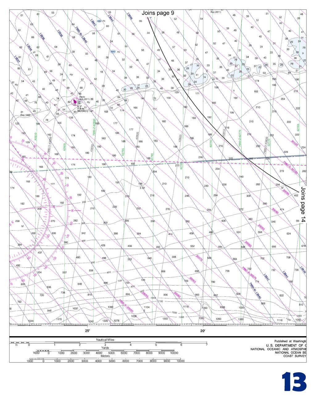
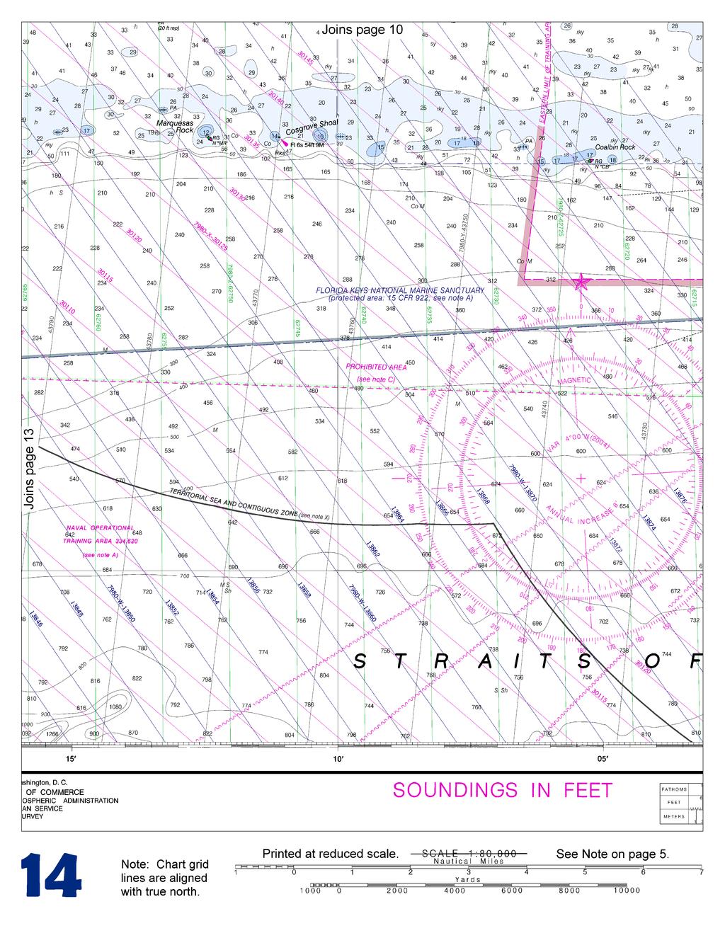
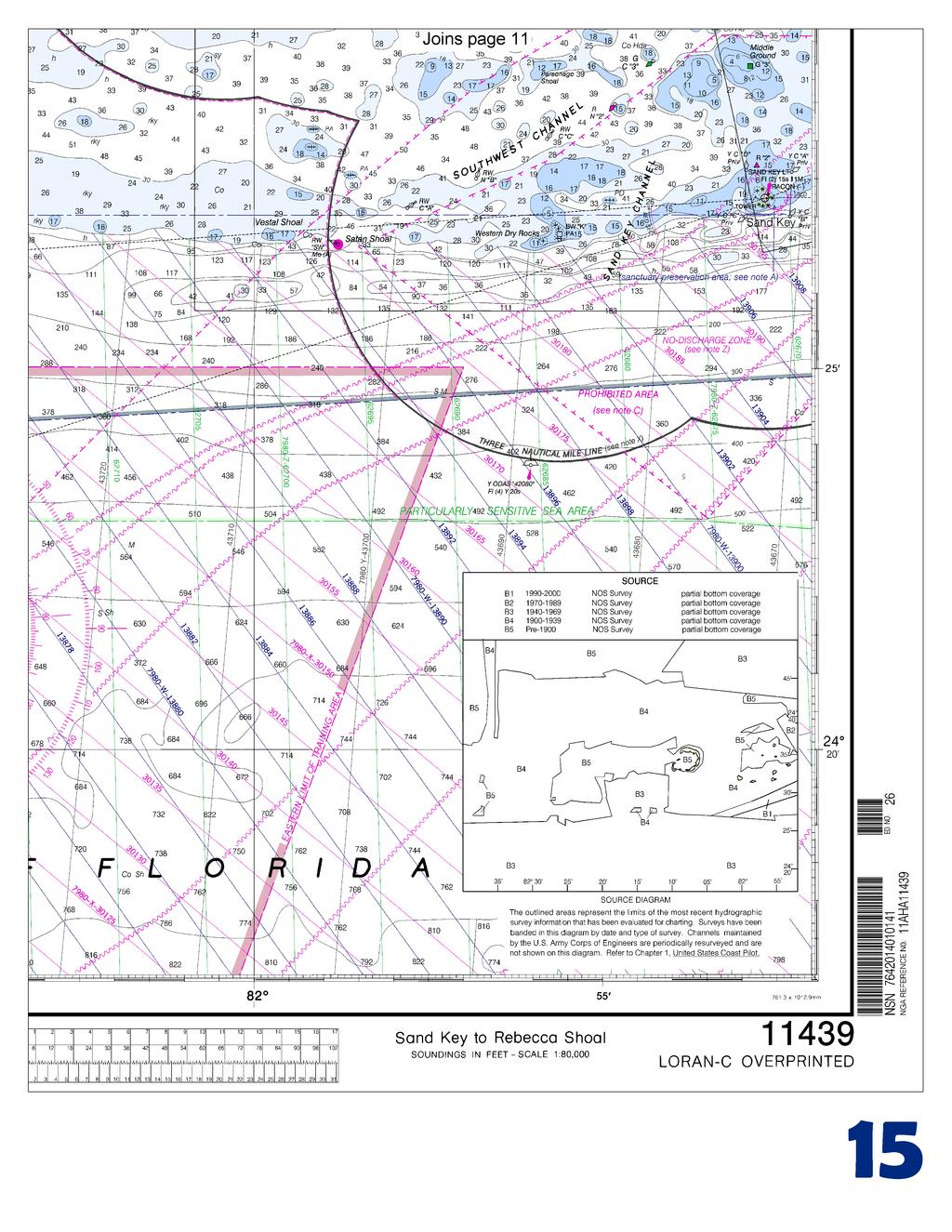
BookletChart. Sand Key to Rebecca Shoal NOAA Chart A reduced-scale NOAA nautical chart for small boaters
|
|
|
- Della Dean
- 6 years ago
- Views:
Transcription


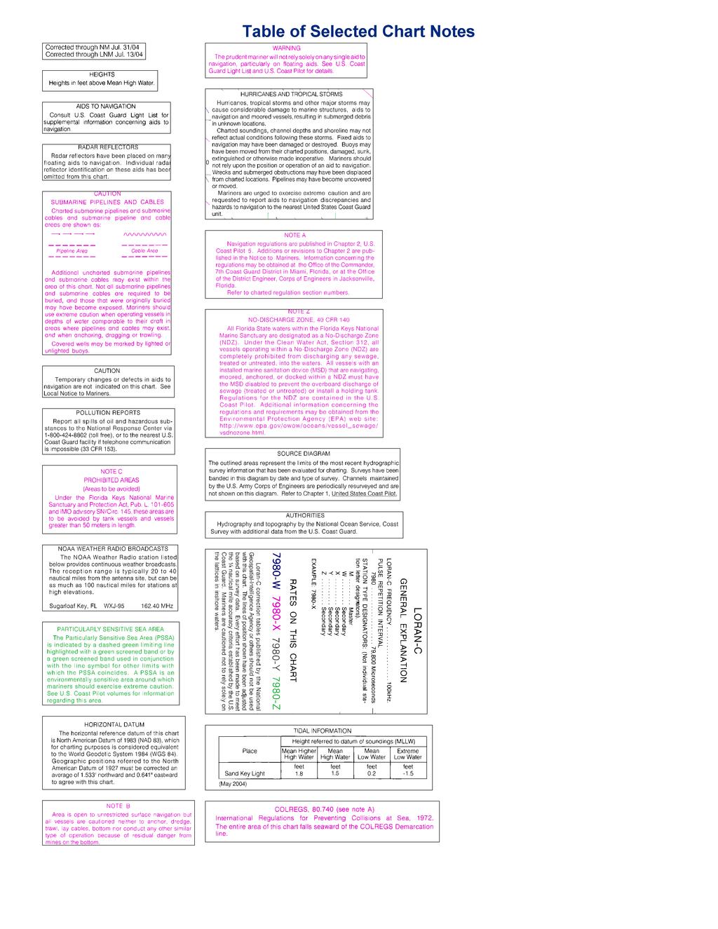
1 BookletChart Sand Key to Rebecca Shoal NOAA Chart A reduced-scale NOAA nautical chart for small boaters When possible, use the full-size NOAA chart for navigation.

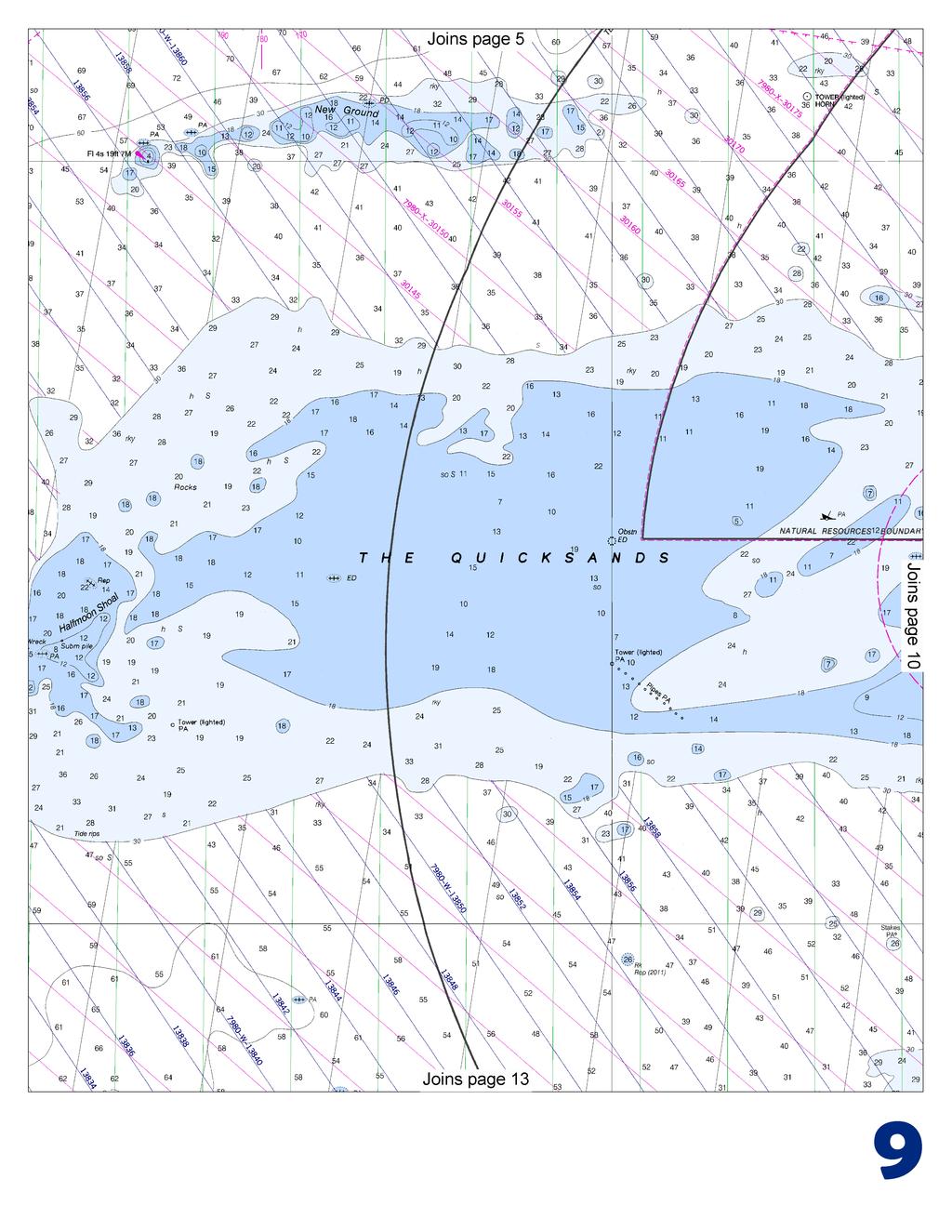
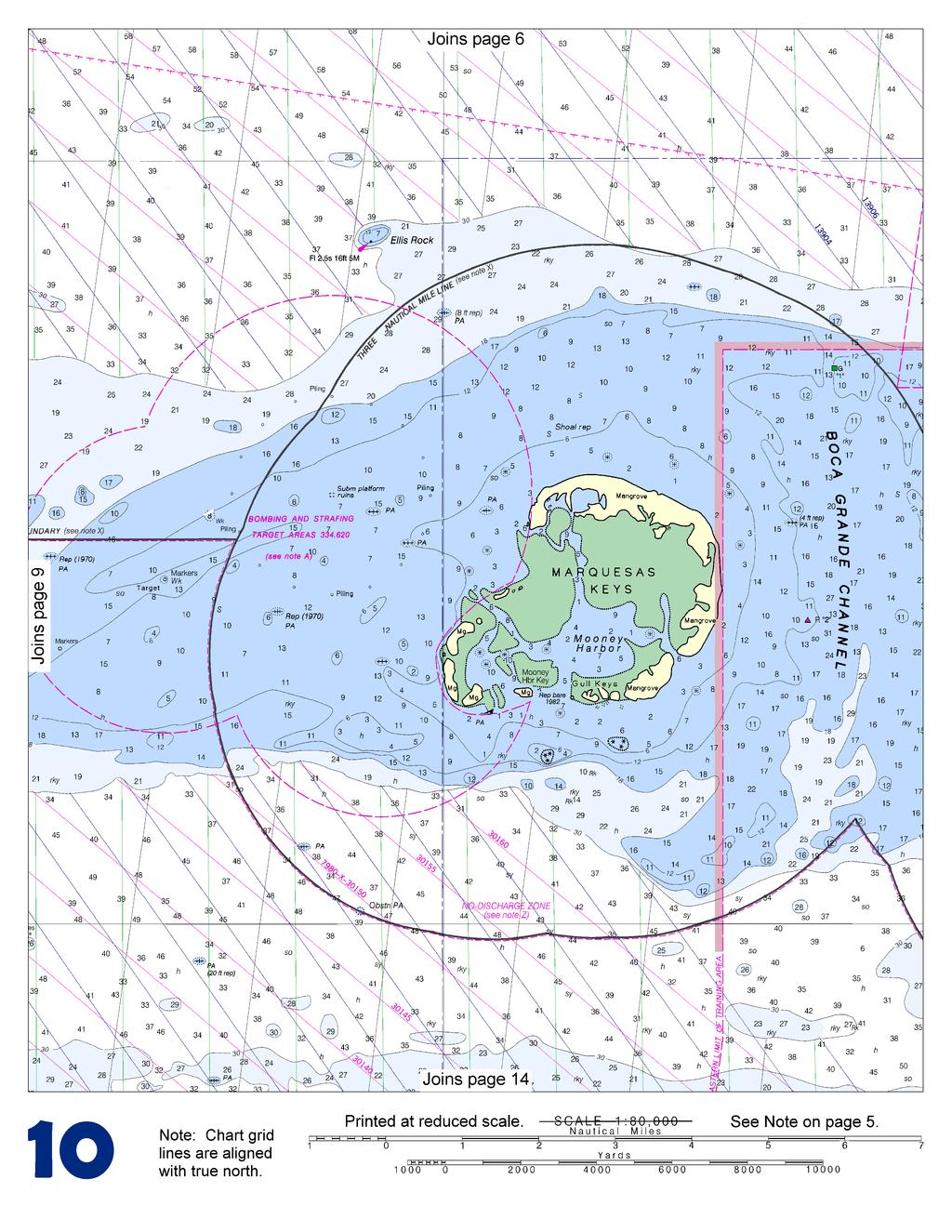
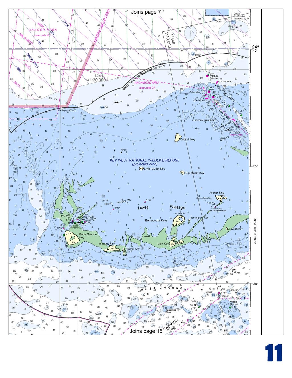
2 Published by the National Oceanic and Atmospheric Administration National Ocean Service Office of Coast Survey NOAA What are Nautical Charts? Nautical charts are a fundamental tool of marine navigation. They show water depths, obstructions, buoys, other aids to navigation, and much more. The information is shown in a way that promotes safe and efficient navigation. Chart carriage is mandatory on the commercial ships that carry America s commerce. They are also used on every Navy and Coast Guard ship, fishing and passenger vessels, and are widely carried by recreational boaters. What is a BookletChart? This BookletChart is made to help recreational boaters locate themselves on the water. It has been reduced in scale for convenience, but otherwise contains all the information of the full-scale nautical chart. The bar scales have also been reduced, and are accurate when used to measure distances in this BookletChart. See the Note at the bottom of page 5 for the reduction in scale applied to this chart. Whenever possible, use the official, full scale NOAA nautical chart for navigation. Nautical chart sales agents are listed on the Internet at This BookletChart does NOT fulfill chart carriage requirements for regulated commercial vessels under Titles 33 and 44 of the Code of Federal Regulations. Notice to Mariners Correction Status This BookletChart has been updated for chart corrections published in the U.S. Coast Guard Local Notice to Mariners, the National Geospatial Intelligence Agency Weekly Notice to Mariners, and, where applicable, the Canadian Coast Guard Notice to Mariners. Additional chart corrections have been made by NOAA in advance of their publication in a Notice to Mariners. The last Notices to Mariners applied to this chart are listed in the Note at the bottom of page 7. Coast Pilot excerpts are not being corrected. For latest Coast Pilot excerpt visit the Office of Coast Survey website at 39 [Coast Pilot 5, Chapter 9 excerpts]. Smith Shoal is covered 11 feet and marked on its NE end by Smith Shoal Light (24 43'06"N., 81 55'18"W.). The light also marks the N approach to the channel and is shown 54 feet above the water from a small black house on a white, hexagonal, pyramidal skeleton tower on piles. A relatively flat-topped coral head, covered by a least depth of 11 feet, is 3.3 miles WSW of the light. Currents are variable along the edge of the reefs, being influenced by winds, by differences of barometric pressure in the Gulf and the Straits of Florida, and by the tides. At times there are strong tidal currents through the passages between the keys. Between Key West Harbor and Boca Grande Channel there is an extensive shoal area in which there are several small scattered keys. A small-craft channel, marked by private daybeacons, extends through the shoal area from Key West to the N side of Boca Grande Key. The channel has a depth of 5 feet except S of Mule Key, near Key West, where the controlling depth is 2 feet. Local knowledge is advised. Boca Grande Channel has a depth of 11 feet from the Straits of Florida to the Gulf of Mexico and is marked by daybeacons, but is seldom used except by local boats of 6 feet or less draft. The channels through Key West Harbor are deeper and better marked, and offer a shorter passage from the Gulf to the Straits of Florida. Good anchorage is available 1 mile NE of Boca Grande Key for boats drawing less than 5 feet. Currents. In Boca Grande Channel the average velocity of the current is 1.2 knots; the flood current sets N and the ebb SSW. The velocity of the current is considerably influenced by the winds. The Marquesas Keys are 4 miles in extent and surrounded by a large shoal area. Mooney Harbor is a central lagoon within Marquesas Keys. The main entrance, close W of Gull Keys, was reported closed by shoaling. Good, protected anchorage can be found in 1 to 4 feet with good holding ground in a small lagoon close SW of Mooney Harbor Key. Another good anchorage was SE of Mooney Harbor with a 4-foot entrance marked by pipes and deeper water within. Entrance into the central lagoon is restricted by a shoal. The lagoon should be entered only during daylight hours and caution should be exercised. Ellis Rock is covered 7 feet and surrounded by depths of 21 to 39 feet; the rock is marked by a light. Danger zones of bombing and strafing target areas, centered on targets, are in the vicinity of Marquesas Keys. A large shoal, the W part of which is known as The Quicksands, extends 18 miles W from the Marquesas Keys. The shoal has a least depth of 2 feet over its E part. A strong E to W current was observed in the area. Shoal, covered 8 feet, is off the W end of The Quicksands. A wreck covered 6 feet and marked by a light is on the W edge of the shoal. Currents. In Boca Grande Channel the average velocity of the current is 1.2 knots; the flood current sets N and the ebb SSW. The velocity of the current is considerably influenced by the winds. Danger zones of bombing and strafing target areas, centered on targets, are in the vicinity of Marquesas Keys. (See , chapter 2, for limits and regulations.) A large shoal, the W part of which is known as The Quicksands, extends 18 miles W from the Marquesas Keys. The shoal is about 4.5 miles wide between the 18-foot curves and has a least depth of 2 feet over its E part. A strong E to W current was observed in the area of The Quicksands in Currents. Between Halfmoon Shoal and Rebecca Shoal at Isaac Shoal the current floods N with an average velocity at strength of about 1.0 knot and ebbs S with an average velocity of about 0.8 knot. The velocity of the current is considerably influenced by the wind. The current S of New Ground Shoal has an average velocity of 0.7 knot with the flood setting NE and the ebb SW. The velocity and direction of the current are influenced considerably by the wind. 2 U.S. Coast Guard Rescue Coordination Center 24 hour Regional Contact for Emergencies RCC New Orleans Commander 8th CG District (504) New Orleans, LA
3
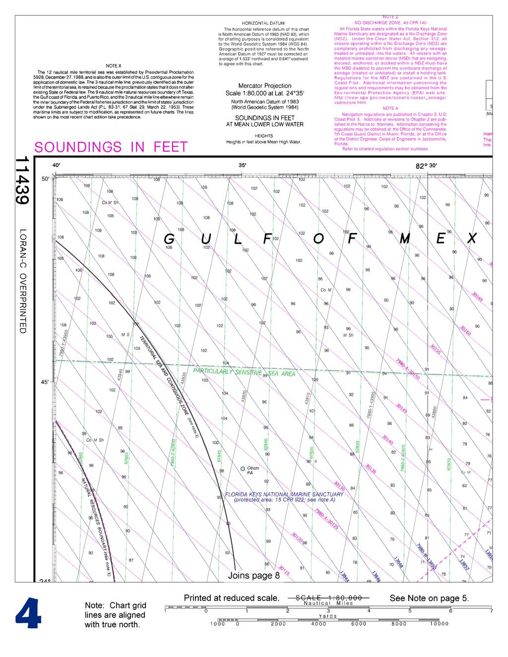
4
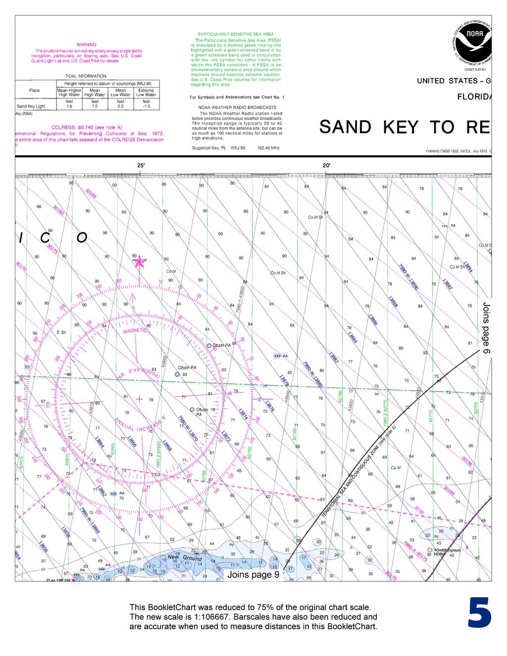
5
6
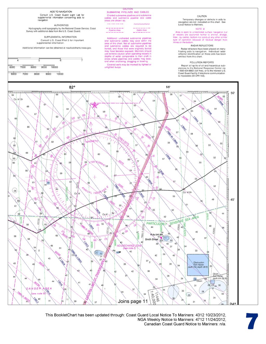
7
8
9
10
11
12
13
14
15


16 VHF Marine Radio channels for use on the waterways: Channel 6 Inter-ship safety communications. Channel 9 Communications between boats and ship-to-coast. Channel 13 Navigation purposes at bridges, locks, and harbors. EMERGENCY INFORMATION Channel 16 Emergency, distress and safety calls to Coast Guard and others, and to initiate calls to other vessels. Contact the other vessel, agree to another channel, and then switch. Channel 22A Calls between the Coast Guard and the public. Severe weather warnings, hazards to navigation and safety warnings are broadcast here. Channels 68, 69, 71, 72 and 78A Recreational boat channels. Getting and Giving Help Signal other boaters using visual distress signals (flares, orange flag, lights, arm signals); whistles; horns; and on your VHF radio. You are required by law to help boaters in trouble. Respond to distress signals, but do not endanger yourself. Distress Call Procedures Make sure radio is on. Select Channel 16. Press/Hold the transmit button. Clearly say: MAYDAY, MAYDAY, MAYDAY. Also give: Vessel Name and/or Description; Position and/or Location; Nature of Emergency; Number of People on Board. Release transmit button. Wait for 10 seconds If no response Repeat MAYDAY call. HAVE ALL PERSONS PUT ON LIFE JACKETS! NOAA Weather Radio All Hazards (NWR) is a nationwide network of radio stations broadcasting continuous weather information directly from the nearest National Weather Service office. NWR broadcasts official Weather Service warnings, watches, forecasts and other hazard information 24 hours a day, 7 days a week. Quick References Nautical chart related products and information - Online chart viewer - Report a chart discrepancy - Chart and chart related inquiries and comments - Chart updates (LNM and NM corrections) - QR Coast Pilot online - Tides and Currents - Marine Forecasts - National Data Buoy Center - NowCoast web portal for coastal conditions - National Weather Service - National Hurrican Center - Pacific Tsunami Warning Center - Contact Us - For the latest news from Coast Survey, This Booklet chart has been designed for duplex printing (printed on front and back of one sheet). If a duplex option is not available on your printer, you may print each sheet and arrange them back-to-back to allow for the proper layout when viewing. NOAA s Office of Coast Survey The Nation s Chartmaker
BookletChart. Intracoastal Waterway Matecumbe to Grassy Key NOAA Chart A reduced-scale NOAA nautical chart for small boaters
 BookletChart Intracoastal Waterway Matecumbe to Grassy Key NOAA Chart 11449 A reduced-scale NOAA nautical chart for small boaters When possible, use the full-size NOAA chart for navigation. Published by
BookletChart. Chesapeake Bay Tangier Sound, Northern Part NOAA Chart A reduced-scale NOAA nautical chart for small boaters
 BookletChart Chesapeake Bay Tangier Sound, Northern Part NOAA Chart 12231 A reduced-scale NOAA nautical chart for small boaters When possible, use the full-size NOAA chart for navigation. Published by
BookletChart. Entrance to San Francisco Bay NOAA Chart A reduced-scale NOAA nautical chart for small boaters
 BookletChart Entrance to San Francisco Bay NOAA Chart 18649 A reduced-scale NOAA nautical chart for small boaters When possible, use the full-size NOAA chart for navigation. Included Area Published by
BookletChart. Chesapeake Bay Severn and Magothy Rivers NOAA Chart A reduced-scale NOAA nautical chart for small boaters
 BookletChart Chesapeake Bay Severn and Magothy Rivers NOAA Chart 12282 A reduced-scale NOAA nautical chart for small boaters When possible, use the full-size NOAA chart for navigation. Published by the
SECTION II CORRECTIONS TO C. G. LIGHT LIST, VOLUME I ATLANTIC COAST, (4) Characteristic. (5) Height
 Characteristic. (5) Height") CORRECTIONS TO C. G. LIGHT LIST, VOLUME I ATLANTIC COAST, 2013 3531 Castine DeepC Wind North Anchor Lighted Buoy NE 3531 Castine DeepC Wind West Anchor Lighted Buoy W 3532 Castine DeepC Wind East Anchor
CORRECTIONS TO C. G. LIGHT LIST, VOLUME I ATLANTIC COAST, 2013 3531 Castine DeepC Wind North Anchor Lighted Buoy NE 3531 Castine DeepC Wind West Anchor Lighted Buoy W 3532 Castine DeepC Wind East Anchor
SECTION II NM 26/10 NAVIGATION PUBLICATIONS ALMANACS CORRECTIONS
 NAVIGATION PUBLICATIONS ALMANACS CORRECTIONS NAUTICAL ALMANAC Ed 2011 NEW EDITION (NGA) 26/10 SAILING DIRECTIONS CORRECTIONS PUB 140 8 Ed 2010 NEW EDITION (NGA) 26/10 COAST PILOT CORRECTIONS COAST PILOT
Wexford Harbour. Yachting Guide. Navigation
 Wexford Harbour Yachting Guide Navigation This document supersedes all previous editions. Approvals: Yacht Club Committee April, 2015 Wexford Board of Directors April, 2015 # Date Section Revision 1 6.5.2015
 Page 1 of 6 Nav-Aid Basics Unlike the roads and highways that we drive on, the waterways we go boating on do not have road signs that tell us our location, the route or distance to a destination, or of
The LA/LB Harbors handle more than 5,500 commercial vessel arrivals per year (excluding local coastwise and Catalina Island traffic).
.") X. SMALL CRAFT For the purpose of the Los Angeles and Long Beach Harbor Safety Plan, pleasure vessels, commercial fishing vessels and sportfishing boats are designated as small craft. A. BACKGROUND: The
X. SMALL CRAFT For the purpose of the Los Angeles and Long Beach Harbor Safety Plan, pleasure vessels, commercial fishing vessels and sportfishing boats are designated as small craft. A. BACKGROUND: The
Chittagong, Bangladesh (Asia Region)
") General Information: Port Information (Asia Region) Extract of port information from Chittagong Port Authority: The Port of Chittagong is the principal Port of the People's Republic of Bangladesh. It is
General Information: Port Information (Asia Region) Extract of port information from Chittagong Port Authority: The Port of Chittagong is the principal Port of the People's Republic of Bangladesh. It is
SECTION XI - COAST PILOT UPDATING. 1. To acquire a general knowledge of the responsibilities of the Auxiliary in COAST PILOT UPDATING activities.
 SECTION XI - COAST PILOT UPDATING INTRODUCTION: The United States Coast Pilot published by the NOS-C&GS, is a series of volumes that supplement the navigational data shown on nautical charts. Sources for
U. S. Coast Guard Sector Boston Merrimack River Approach and Entrance, MA. Waterways Management Survey
 U. S. Coast Guard Sector Boston Merrimack River Approach and Entrance, MA. Waterways Management Survey The Waterways Analysis and Management Survey (WAMS) process is an essential component of both the
ATON System Workshop
 ATON System Workshop ATON System: Real-time current measurements from Coast Guard navigation buoys in ports, bays and the coastal ocean Aid-to-Navigation = ATON ATON System Workshop Outline: Overview of
SECTION II CORRECTIONS TO C. G. LIGHT LIST, VOLUME I ATLANTIC COAST, (4) Characteristic. (5) Height
 Characteristic. (5) Height") CORRECTIONS TO C. G. LIGHT LIST, VOLUME I ATLANTIC COAST, 2015 238 University of New Hampshire Lighted Research Wave Buoy 42-47-52.80N 70-10-04.80W FlY 20s Yellow. *Add Note: Aids maintained Apr. 15 to
CORRECTIONS TO C. G. LIGHT LIST, VOLUME I ATLANTIC COAST, 2015 238 University of New Hampshire Lighted Research Wave Buoy 42-47-52.80N 70-10-04.80W FlY 20s Yellow. *Add Note: Aids maintained Apr. 15 to
2 Boating Rules and Regulations... 73
 Contents at a Glance Chapter 1 Boat Design and Construction Chapter 2 Boating Rules and Regulations Chapter 3 Navigation Rules (ColRegs) Chapter 4 Boat Operating and Seamanship Chapter 5 Piloting and Navigation
SECTION II NM 11/13 NAVIGATION PUBLICATIONS COAST PILOT CORRECTIONS. Chapter 4 Paragraphs 85 to 86; read: (85)
") NAVIGATION PUBLICATIONS COAST PILOT CORRECTIONS COAST PILOT 1 42 Ed 2012 Change No. 13 LAST NM 9/13 Chapter 4 Paragraph 9; read: (9) Round Rock, which uncovers, and The Boring Stone, 3 feet high and bare,
NAVIGATION PUBLICATIONS COAST PILOT CORRECTIONS COAST PILOT 1 42 Ed 2012 Change No. 13 LAST NM 9/13 Chapter 4 Paragraph 9; read: (9) Round Rock, which uncovers, and The Boring Stone, 3 feet high and bare,
SECTION II CORRECTIONS TO C. G. LIGHT LIST, VOLUME I ATLANTIC COAST,
 CORRECTIONS TO C. G. LIGHT LIST, VOLUME I ATLANTIC COAST, 2011 *10450 360 MARBLEHEAD LIGHT 42-30-19.45N 70-50-01.47W 11760 - Channel Lighted Buoy 28 42-14-53.10N 70-57-43.11W 20410 Gavitt Point Outfall
Astrolabe Reef Access Plan Stakeholder Presentation
 Astrolabe Reef Access Plan Stakeholder Presentation *Rena s bow thruster approx 18m Agenda Overview Access Plan Introduction State of the Reef & Wreck Site What to Expect Timetable & Activity Questions
Visiting Lake Macquarie
 Visiting Lake Macquarie Lake Macquarie is the largest coastal salt water lake in Australia and is a prime boating destination for both small and large vessels. Many sailing regattas and fishing activities
COXSWAIN NAVIGATION EXERCISES AUS197 NAME:
 COXSWAIN NAVIGATION EXERCISES AUS197 NAME: A deviation card is supplied at the end of this file. Check the answers Question 1 Using any chart (or use the AUS 197 extract) to: 1. Identify a distance of
LIST OF NOTICES TO MARINERS 2017 PAC 201 JUAN DE FUCA STRAIT AND STRAIT OF GEORGIA, FIRST EDITION, 2012
 1 Chapter 1 After paragraph 154 Insert: 154.1 Pacific Gateway Marina (250-412-5509) is located west of the community wharf. Moorage, gas, diesel, a launching ramp and deep water berths for sailboats are
MAC Transit Advisories as of April 30, 2018
 MAC Transit Advisories as of April 30, 2018 The Mariners Advisory Committee for the Bay and River Delaware was established in October 1964. Its members and associate members are mainly comprised of master
Nautical Chart Challenge
 Discover Your World With NOAA Nautical Chart Challenge For as long as anyone in his family could remember, Francis Beaufort wanted to make scientific observations from the deck of a ship. In 1789 at the
Required knowledge for Cook Strait endorsement
 Required knowledge for Cook Strait endorsement Last updated: March 2018 This document is uncontrolled if printed, please refer to the Maritime New Zealand website for the latest version. Cook Strait is
Dive Operations Plan for Personal Submersibles. Revision
 Dive Operations Plan for Personal Submersibles Revision 2011.1 1 Table of Contents 1 EVENT...3 1.1 Summary of planned dive...3 1.1.1 PSUBS Guidelines...3 1.1.2 Maximum dive depth planned...3 1.1.3 Number
watersafety.usace.army.mil Brochure created by CEMVR IM-I
 watersafety.usace.army.mil Brochure created by CEMVR IM-I Introduction We hope you find this information useful for boating on the Upper Mississippi River and Illinois Waterway. The purpose of this booklet
Firth of Forth. Passage Plans
 Firth of Forth Passage Plans Inward and Outward Passage Plans For the Firth of Forth within the Firth of Forth Pilotage Area. This plan has been prepared with the co-operation of personel from The Association
LOCAL NOTICE TO MARINERS
 USCG Notice to Mariners 3/7/18 (View full Notice here) LNM 10/18 Coast Guard District 1: U.S. Department of Homeland Security United States Coast Guard LOCAL NOTICE TO MARINERS COASTAL WATERS FROM EASTPORT,
HARBOR INFRASTRUCTURE INVENTORIES Kenosha Harbor, Wisconsin
 HARBOR INFRASTRUCTURE INVENTORIES Kenosha Harbor, Wisconsin Harbor Location: Kenosha Harbor is on the west shore of Lake Michigan about 54 miles north of Chicago, Illinois. Authority: River & Harbor Acts
EBA Position Statement AIS Virtual Aids to Navigation
 EBA Position Statement AIS Virtual Aids to Navigation Document date: 17 October 2015 Latest update: 9 December 2015 Executive Summary The European Boating Association 1 (EBA) recognises the value of Automatic
Chapter 8. Port hand buoy. Starboard hand buoy. Canadian Aids to Navigation System (CANS) 8.1 Introduction. 8.2 Lateral Buoys
 8.1 Introduction. 8.2 Lateral Buoys") Chapter 8 Canadian Aids to Navigation System (CANS) 8.1 Introduction Various buoys, beacons and signs are known as "Aids to Navigation" or "Navigation Aids". They are devices or systems external to the
Chapter 8 Canadian Aids to Navigation System (CANS) 8.1 Introduction Various buoys, beacons and signs are known as "Aids to Navigation" or "Navigation Aids". They are devices or systems external to the
Oil Tanker - VLCC. Yosu Inward Transit Monitoring (Entering into the Port of Yosu on a Loaded VLCC) LEG 1: APPROACHING ANCHORAGE AND PILOT STATION
 LEG 1: APPROACHING ANCHORAGE AND PILOT STATION") Yosu Inward Transit Monitoring (Entering into the Port of Yosu on a Loaded VLCC) Vessel VLCC Date 11/05/2016 Draft Fwd 21.0 D Draft Midship 21.0 Draft Aft 21.0 Max Allowed arrival draft by the port: 21.0
Yosu Inward Transit Monitoring (Entering into the Port of Yosu on a Loaded VLCC) Vessel VLCC Date 11/05/2016 Draft Fwd 21.0 D Draft Midship 21.0 Draft Aft 21.0 Max Allowed arrival draft by the port: 21.0
LOCAL NOTICE TO MARINERS
 USCG Notice to Mariners 3/26/15 (View full Notice here) LNM 12/15 Coast Guard District 1 : U.S. Department of Homeland Security United States Coast Guard LOCAL NOTICE TO MARINERS COASTAL WATERS FROM EASTPORT,
WELCOME TO THE MILLENNIUM RIBBLE LINK
 WELCOME TO THE MILLENNIUM RIBBLE LINK The prestigious 5.8m project to construct the Millennium Ribble Link opened in 2002. This is the first new navigation to be built in England since the Manchester Ship
Plot the Path. Mary Anne Otten. lesson three
 Plot the Path Mary Anne Otten lesson three Subject/Grade: Grade 2, Math, Social Studies, Science Duration: one class period Materials needed: Per class: Day the Great Lakes Drained Away by Charles Ferguson
INTER CLUB SERIES SAILING INSTRUCTIONS
 INTER CLUB SERIES - 2011 SAILING INSTRUCTIONS 1. RULES The regatta will be governed by the Racing Rules of Sailing (RRS), 2009-2012 including the January 2010 amendments, the prescriptions of U.S. Sailing
13. TIDES Tidal waters
 Water levels vary in tidal and non-tidal waters: sailors should be aware that the depths shown on the charts do not always represent the actual amount of water under the boat. 13.1 Tidal waters In tidal
Nicholas Brown. 31 Bennett Rd Wolfeboro NH Application submitted
 Nicholas Brown 31 Bennett Rd Wolfeboro NH 03894 603-856-5454 Nick4634@gmail.com Application submitted 8-12-2017 Description of proposed project A. General Methodology The site located approximately 600
Delaware River Vessel Reporting System Mariners Advisory Committee For
 Delaware River Vessel Reporting System Mariners Advisory Committee For the Bay and River Delaware The Mariner's Advisory Committee is comprised of Master Mariners, River Pilots, and concerns itself with
U.S. Aids To Navigation System Brochure U.S. Coast Guard, Office of Aids to Navigation (202) ,
 ,") AIDS TO NAVIGATION Learning Objectives: As a result of this session the participant should: Understand the principal buoyage systems in the United States. Become aware of the characteristics of the buoy
AIDS TO NAVIGATION Learning Objectives: As a result of this session the participant should: Understand the principal buoyage systems in the United States. Become aware of the characteristics of the buoy
FILED 12/04/2017 3:00 PM ARCHIVES DIVISION SECRETARY OF STATE
 OFFICE OF THE SECRETARY OF STATE DENNIS RICHARDSON SECRETARY OF STATE LESLIE CUMMINGS DEPUTY SECRETARY OF STATE PERMANENT ADMINISTRATIVE ORDER OSMB 4-2017 CHAPTER 250 OREGON STATE MARINE BOARD ARCHIVES
SECTION II CORRECTIONS TO C. G. LIGHT LIST, VOLUME I ATLANTIC COAST, (4) Characteristic. (5) Height. Fl G 4s 4 Green. Fl G 4s 4 Green.
 Characteristic. (5) Height. Fl G 4s 4 Green. Fl G 4s 4 Green.") CORRECTIONS TO C. G. LIGHT LIST, VOLUME I ATLANTIC COAST, 2010 742 Fishing Grounds Obstruction Shoal Buoy 6 40 25 25 N 73 52 20 W Red. * 745 New York Bight Dumping Ground Lighted Buoy 3 4555 Two Bush Ledge
CORRECTIONS TO C. G. LIGHT LIST, VOLUME I ATLANTIC COAST, 2010 742 Fishing Grounds Obstruction Shoal Buoy 6 40 25 25 N 73 52 20 W Red. * 745 New York Bight Dumping Ground Lighted Buoy 3 4555 Two Bush Ledge
Plot the Path into the Harbor
 Plot the Path into the Harbor By Mary Anne Otten, Rudyard Area Schools and Joan Chadde, Michigan Technological University Subject/Grade: Grade 3 6, Math, Social Studies, Science Duration: 35 minutes Lesson
General Boating Knowledge. Common Sense before leaving shore
 General Boating Knowledge Common Sense before leaving shore Engines work, battery charged, hull, tires, drain plug, etc Safety equipment example - Life jackets fit correctly for everyone on board Safety
Anchoring Is Important
 BCC Sailing Classes - Third Theory Anchoring Anchoring Is Important 1 The Anchor is your last resort. Anchoring Keep off a lee shore. Needs to be shaped (type of anchor) to bury in the type of bottom for
Nanaimo Ocean Swim and Newcastle SUP Race Safety Plan
 Nanaimo Ocean Swim and Newcastle SUP Race Safety Plan Use of this document Permission is granted to reproduce any information in this document; however, please notify the author (Matthew Lamb) if doing
2018 SPINNAKER CUP San Francisco To Monterey Saturday, May 26
 2018 SPINNAKER CUP San Francisco To Monterey Saturday, May 26 SAILING INSTRUCTIONS Organizing Authorities: The San Francisco Yacht Club, Belvedere, CA and Monterey Peninsula Yacht Club, Monterey, CA 1
River Tay. Passage Plan
 River Tay Passage Plan Inward and Outward Passage Plan For the River Tay within the Port of Dundee Pilotage Area. This plan has been prepared with the co-operation of personel from The Association of Dundee
WELCOME TO THE. Pleasure Craft Operator Training (PCOC)
") WELCOME TO THE Pleasure Craft Operator Training (PCOC) REGULATIONS The Competency of Operators of Pleasure Craft Regulations require operators of pleasure craft fitted with a motor and used for recreational
WELCOME TO THE Pleasure Craft Operator Training (PCOC) REGULATIONS The Competency of Operators of Pleasure Craft Regulations require operators of pleasure craft fitted with a motor and used for recreational
MARATHON SAIL and POWER SQUADRON Women Making Waves
 MARATHON SAIL and POWER SQUADRON Women Making Waves www.marathonpowersquadron.org Gregory Absten, Cdr, Marathon Sail & Power Squadron Fleet Captain, Marathon Yacht Club MARATHON SAIL and POWER SQUADRON
 7 The Guidelines of Measures for preventing Typhoon Disaster ( Objective ) Article1 The objective of this guideline is to establish steps necessary to implement the measures for preventing typhoon
Important Information for Yachts & Agents
 Important Information for Yachts & Agents 1. The Yacht Services of Alaska agent is your contact for all requests for pilotage and pilot boat services. Refer all communication regarding pilotage to them.
Mr. Barry Dragon, March 16, 2015 Commander, Seventh Coast Guard District (dob) Brickell Plaza 909 S.E. 1st Ave. Miami, FL
 Brickell Plaza 909 S.E. 1st Ave. Miami, FL") Mr. Barry Dragon, March 16, 2015 Commander, Seventh Coast Guard District (dob) Brickell Plaza 909 S.E. 1st Ave. Miami, FL 33130-3050 Commander, On behalf of the Florida Council of Yacht Clubs representing
Mr. Barry Dragon, March 16, 2015 Commander, Seventh Coast Guard District (dob) Brickell Plaza 909 S.E. 1st Ave. Miami, FL 33130-3050 Commander, On behalf of the Florida Council of Yacht Clubs representing
SS&S Chapter 8 Instructor Guide
 SS&S Chapter 8 Instructor Guide The Rules of the Nautical Road The PowerPoints (PPT) slides for this SS&S chapter were copied from the BS&S-13 th Ed PPT because they are identical. Only the chapter numbers
OSAKA MARTIS USER MANUAL TABLE OF CONTENTS
 OSAKA MARTIS USER MANUAL TABLE OF CONTENTS Ⅰ Ⅱ Ⅲ INTRODUCTION OPERATIONAL CONCEPT OF "Osaka MARTIS" IMPORTANT NAVIGATIONAL RULES Ⅳ COMMUNICATION 1 VHF Channels 2 Language Ⅴ PRE-ENTRY REPORT AND POSITION
LOWER MISSISSIPPI RIVER PRE-ENTRY INFORMATION
 LOWER MISSISSIPPI RIVER PRE-ENTRY INFORMATION Notice of Arrivals Prior to Arrival at any U.S. port, the vessel master should ensure a complete and accurate Notice of Arrival has been submitted to National
THE GREAT VALLEJO RACE MAY 1 and 2, 2010 SAILING INSTRUCTIONS
 THE GREAT VALLEJO RACE MAY 1 and 2, 2010 SAILING INSTRUCTIONS Vallejo Yacht Club PO Box 311 Vallejo, California 94590 YRA of SF Bay Quarters 35 S, Fort Mason San Francisco, CA 94123 1.0 RULES: The races
GULF OF MEXICO. 268 U.S. Coast Pilot 5, Chapter 6 04 AUG (see catalog for complete coverage) General Index of Chart Coverage in Chapter 6
 General Index of Chart Coverage in Chapter 6") 268 U.S. Coast Pilot 5, Chapter 6 04 AUG 2013 General Index of Chart Coverage in Chapter 6 (see catalog for complete coverage) 11406 11405 11404 11383 11384 11382 11388 11392 11391 11389 11390 11393 88
268 U.S. Coast Pilot 5, Chapter 6 04 AUG 2013 General Index of Chart Coverage in Chapter 6 (see catalog for complete coverage) 11406 11405 11404 11383 11384 11382 11388 11392 11391 11389 11390 11393 88
Chart Features Maritime maps and Admiralty charts have these features:
 Introduction to Charts A chart or map of the area is an important safety item to carry on board. It allows the Master to obtain knowledge of the area to be travelled, and indicates the navigable channels
New Syllabus for 12 Nautical Miles
 New Syllabus for 12 Nautical Miles 1. Legal and professional responsibilities of skippers under the Tourism Authority Act 2006. a) The meaning of Skipper as defined under the Tourism Authority Act 2006
Please contact our Education Officer if you are interested in any of these courses.
 Please contact our Education Officer if you are interested in any of these courses. Lt/Cdr Jack McKinnon, AP 770-365-9576 or Jakmck@frontier.com Elective Courses Six Elective Courses are offered by USPS.
Port of Port Elizabeth Information
 LOCATION Latitude 34º 01 S Longitude 25º 42 E PILOTAGE Pilotage is compulsory. Rendezvous point is 2.2 nautical miles NE of the port entrance on the leading lights. Pilot transfer is by pilot boat, unless
Marblehead Racing Emergency Response Manual
 Marblehead Racing Emergency Response Manual When in doubt in an emergency situation, call VHF 16 or 9-1-1 This manual is for Race Committee RO (office and signal vessel as reference), racers, Harbor Masters,
Gorgon - Pilotage - Passage Plan PBG to Materials Offloading Facility (MOF)
") 1.0 Introduction Vessels transiting within port limits from the Barrow Island Pilot Boarding Ground (PBG) to the require an approved passage plan which can be shared between Pilots and vessel Masters.
1.0 Introduction Vessels transiting within port limits from the Barrow Island Pilot Boarding Ground (PBG) to the require an approved passage plan which can be shared between Pilots and vessel Masters.
Gorgon - Pilotage - Passage Plan Materials Offloading Facility (MOF) to PBG
 to PBG") Gorgon - Pilotage - Passage Plan Materials Offloading Facility (MOF) to PBG 1.0 Introduction Vessels transiting within port limits from the Materials Offloading Facility (MOF) to the Barrow Island Pilot
Gorgon - Pilotage - Passage Plan Materials Offloading Facility (MOF) to PBG 1.0 Introduction Vessels transiting within port limits from the Materials Offloading Facility (MOF) to the Barrow Island Pilot
Belmont Yacht Club THERE AND BACK CHICAGO, IL AUGUST 4, 2018 SAILING INSTRUCTIONS
 Belmont Yacht Club THERE AND BACK CHICAGO, IL AUGUST 4, 2018 SAILING INSTRUCTIONS 1. ORGANIZING AUTHORITY The Belmont Yacht Club Race Committee (BYCRC) shall represent the Belmont Yacht Club as the Organizing
EPA Vessel Safety during Response Operations
 EPA Vessel Safety during Response Operations EPA Vessel Safety Manual EPA employees who operate Class A vessels under 45 feet in length, shall conform to the minimum qualifications; 1) Approval by the
National Maritime Center
 National Maritime Center Providing Credentials to Mariners (Sample Examination) Page 1 of 16 Choose the best answer to the following Multiple Choice Questions. 1. On U.S. charts, you can tell if a named
MARINE INFORMATION REPORT AND SUGGESTION SHEET INSTRUCTIONS
 MARINE INFORMATION REPORT AND SUGGESTION SHEET INSTRUCTIONS We value your suggestions to improve our products. The Marine Information Report and Suggestion Sheet is provided for users to submit corrective
SAILING INSTRUCTIONS BILLY RUN. Saturday 28 April The organising authority (OA) is the South of Perth Yacht Club
 is the South of Perth Yacht Club") SAILING INSTRUCTIONS BILLY RUN Saturday 28 April 2018 The organising authority (OA) is the South of Perth Yacht Club 1. RULES 1.1. The regatta will be governed by the rules as defined in The Racing Rules
SAILING INSTRUCTIONS BILLY RUN Saturday 28 April 2018 The organising authority (OA) is the South of Perth Yacht Club 1. RULES 1.1. The regatta will be governed by the rules as defined in The Racing Rules
SECTION II CORRECTIONS TO C. G. LIGHT LIST, VOLUME I ATLANTIC COAST,
 CORRECTIONS TO C. G. LIGHT LIST, VOLUME I ATLANTIC COAST, 2016 2935 Horseshoe Ledge Daybeacon 2 44-19-22.26N 68-46-00.66W 2940 Horseshoe Cove Buoy 3 44-19-54.72N 68-46-07.50W 2945 Horseshoe Cove Daybeacon
Aids to navigation can include buoys, day beacons, range markers, and lighthouses.
 This boating safety course manual has been approved by Transport Canada strictly on the basis that it meets the minimum requirements of basic boating safety knowledge set out in Transport Canada s Boating
NOTICES TO MARINERS 1 to 46 ANNUAL EDITION 2018
 NOTICES TO MARINERS 1 to 46 CANADIAN COAST GUARD www.notmar.gc.ca Notices to Mariners 1 to 46 Annual Edition 2018 Published under the authority of: Canadian Coast Guard Programs Aids to Navigation and
TICES TO MARINERS 1 TO 46 ANNUAL EDITION 2018 SECTION A AIDS TO NAVIGATION AND MARINE SAFETY
 A5 NAVIGATION SAFETY 10 Routeing of Ships 1 GENERAL 1.1 Rule 10 of the Collision Regulations applies to all ships navigating in or near a routeing system. 1.2 The information on ships' routeing in this
Code of Federal Regulations
 Page 1 of 6 Code of Federal Regulations Title 33 - Navigation and Navigable Waters Volume: 2 Date: 2010-07-01 Original Date: 2010-07-01 Title: Section 165.1325 - Regulated Navigation Areas; Bars Along
Class B Accident Report. Legacy Grounding
 Class B Accident Report Legacy Grounding At Fiordland on 3 December 2004 REPORT NO: 04 3614 LEGACY GROUNDING At about 1230 hours New Zealand Daylight Time (NZDT), on 3 December 2004, the fishing vessel
Gorgon - Pilotage - Passage Plan - PBG to Gorgon Marine Terminal - Alternative Route
 1.0 Introduction This work instruction outlines the passage plan to be used by vessels transiting from the Port of Barrow Island PBG to the Gorgon Marine Terminal, via the alternative route, with a Pilot
4 th Annual John Mclaughlin Memorial Regatta (JMMR) Notice of Race/GSI Amendment
 Notice of Race/GSI Amendment") 4 th Annual John Mclaughlin Memorial Regatta (JMMR) Notice of Race/GSI Amendment West River Sailing Club Saturday October Entry Due: Saturday June 24 th -Sunday June 25 th 2017 Entry Fee: $30.00 Online
4 th Annual John Mclaughlin Memorial Regatta (JMMR) Notice of Race/GSI Amendment West River Sailing Club Saturday October Entry Due: Saturday June 24 th -Sunday June 25 th 2017 Entry Fee: $30.00 Online
A buoy, for example is an aid to navigation. Aids to navigation include many types of buoys as well as day beacons, range markers, and lighthouses.
 This online study guide has been approved by Transport Canada strictly on the basis that it meets the requirements of the Standard for Pleasure Craft Operator Testing over the Internet (TP 15080E) and
HOUSTON SEA CHEST CLOGGING SURVEY
 HOUSTON SEA CHEST CLOGGING SURVEY *** YOUR HELP IS VOLUNTARY AND ANONYMOUS*** ***PLEASE DO NOT INCLUDE VESSEL NAME OR NUMBER *** IT IS 2015 MENHADEN SEASON IN THE HOUSTON SHIP CHANNEL To Vessel Master/Chief
LOCAL NOTICES TO MARINERS 1/13. Valid from: 01/1/13 Expires on: Until withdrawn. HHAL Local Notice To Mariners In Force
 LOCAL NOTICES TO MARINERS 1/13 Valid from: 01/1/13 Expires on: Until withdrawn HHAL Local Notice To Mariners In Force 1. 01/07 Lower Leading Light / Day Mark 2. 03/11 North Quay Works 3. 08/11 Bathymetric
AID VERIFIER QUIZ. 1. How often is the Light List published? a. One a year b. Twice a year c. Every Month d. Quarterly
 Qualification as an Aid Verifier in the Auxiliary presumes a knowledge of navigational aids above that of the ordinary member. Questions on the subject may be directed to the AV as he/she is considered
Vessel Traffic in the Salish Sea Mitigating Risk... Captain Joe Raymond Coast Sector Puget Sound
 Vessel Traffic in the Salish Sea Mitigating Risk.... Captain Joe Raymond Coast Sector Puget Sound Overview Prevention Waterways Management Oil Spill Data Mitigating Risks Sector Puget Sound AOR Blan k
LANGLEY SQUADRON MID-TERM KNOWLEDGE CHECK
 LANGLEY SQUADRON MID-TERM KNOWLEDGE CHECK Seamanship 1. (d) only (a) and (c) 2. (d) all of the above 3. (a) chocks 4. (a) placed at the end of the cord and the tool plugged directly in (a) Inboard Direct
CABRILLO BEACH YACHT CLUB DANA POINT YACHT CLUB
 SAILING INSTRUCTIONS May 28 & 29, 2016 CABRILLO BEACH YACHT CLUB DANA POINT YACHT CLUB 1 RULES GENERAL 1.1 This race shall be governed by the Rules as defined in the 2013-2016 Racing Rules of Sailing (RRS).
Paddle Craft Vessel Safety Check Review D11NR Vessel examiner swe save lives! Prepared by: Mike Lauro DSO-VE 11NR
 1. Paddle Craft Vessel Safety Check Review D11NR Vessel examiner swe save lives! Prepared by: Mike Lauro DSO-VE 11NR Paddle Craft The fastest growing area of Recreational Boating! What s a Paddle Craft?
SECTION II CORRECTIONS TO C. G. LIGHT LIST, VOLUME I ATLANTIC COAST,
 CORRECTIONS TO C. G. LIGHT LIST, VOLUME I ATLANTIC COAST, 2014 9150 SALISBURY POINT LIGHT 42-50-13.70N 70-54-45.66W 19468 Quonochontaug Pond Buoy 1 41-20-25.01N 71-43-29.13W 19469 Quonochontaug Pond Buoy
Expanding Anchoring Away
 Expanding Anchoring Away Vessel taxonomy &territorial waters Maritime and admiralty law distinguished The right to navigate Federal navigational servitude as applied CZMA, reverse federalism & Florida
SECTION II NM 38/12 NAVIGATION PUBLICATIONS. Chapter 8 Paragraph 357; read: (357) COAST PILOT CORRECTIONS
 COAST PILOT CORRECTIONS") NAVIGATION PUBLICATIONS COAST PILOT CORRECTIONS COAST PILOT 1 42 Ed 2012 Change No. 4 LAST NM 35/12 Appendix A Paragraph 136; read: (136) NAVTEX coverage is reasonably continuous to 200 NM off the U.S.
NAVIGATION PUBLICATIONS COAST PILOT CORRECTIONS COAST PILOT 1 42 Ed 2012 Change No. 4 LAST NM 35/12 Appendix A Paragraph 136; read: (136) NAVTEX coverage is reasonably continuous to 200 NM off the U.S.
Boat Operator Certification Committee April 2016
 Boat Operator Certification Committee April 2016 Overview This presentation provides information on U. S. Coast Guard licensing as it relates to USPS On the Water Training programs. It answers many of
Scope: This is the minimum required standard that applies to all basic boating courses in the U.S. states and territories and District of Columbia.
 Title: Level 1 Basic Boating Knowledge Scope: This is the minimum required standard that applies to all basic boating courses in the U.S. states and territories and District of Columbia. Purpose: To establish
1.1 The organizing authority of the Skippers Club Race is the Midwest Open Racing Fleet of Chicago
 SKIPPERS CLUB RACE SEPTEMBER 8, 2018 NOTICE OF RACE and SAILING INSTRUCTIONS 1. RULES 1.1 The organizing authority of the Skippers Club Race is the Midwest Open Racing Fleet of Chicago 1.2 The race will
THE SYLLABUS FOR WRITTEN EXAMINATION PILOT'S FOURTH CLASS LICENCE (TEES AND HARTLEPOOL) AND
 AND") PD TEESPORT CONSERVANCY DIVISION HARBOUR MASTER'S OFFICE THE SYLLABUS FOR WRITTEN EXAMINATION IN RESPECT OF A PILOT'S FOURTH CLASS LICENCE (TEES AND HARTLEPOOL) AND PILOTAGE EXEMPTION CERTIFICATE (Issued
PD TEESPORT CONSERVANCY DIVISION HARBOUR MASTER'S OFFICE THE SYLLABUS FOR WRITTEN EXAMINATION IN RESPECT OF A PILOT'S FOURTH CLASS LICENCE (TEES AND HARTLEPOOL) AND PILOTAGE EXEMPTION CERTIFICATE (Issued
Jack Hyde Memorial Navigation Contest Saturday, March 18, 2017 The Same Only Different
 Jack Hyde Memorial Navigation Contest Saturday, March 18, 2017 The Same Only Different March 17, 2018 Skippers, Mates and Crews, On behalf of the Tacoma Yacht Club let me welcome you to the running of
GUIDELINES FOR NAVIGATION UNDER THE CONFEDERATION BRIDGE
 (12/2009) GUIDELINES FOR NAVIGATION UNDER THE CONFEDERATION BRIDGE REVISION 1 DECEMBER 2009 Responsible Authority The Regional Director Marine Safety Atlantic Region is responsible for this document, including
Hydrographic Surveying Methods, Applications and Uses
 Definition: Hydrographic Surveying Methods, Applications and Uses It is the branch of surveying which deals with any body of still or running water such as a lake, harbor, stream or river. Hydrographic
Berkeley Island Marine Pre-Rental Instructions. If you do not have a
 Berkeley Island Marine Pre-Rental Instructions. If you do not have a safe boating certificate or a boat license in the state of NJ, or an equivalent in another state, you must take this instruction. Approximate
2005 ABC. Chapter 3 Part 2. Navigating with ATON's. Revision to D-13 Local Notes. Instructor Notes for Mike Brough. Mike Brough
 2005 ABC Chapter 3 Part 2 Navigating with ATON's Revision to D-13 Local Notes Instructor Notes for Mike Brough Mike Brough June 24 2008 June 24 2008 Slide 1 June 24 2008 New graphics Navigating on Water
Harbourmaster s Office Tamaki River. Navigation Safety Operating Requirements 2014
 Harbourmaster s Office Tamaki River Navigation Safety Operating Requirements 2014 Auckland Council Harbourmaster s Office TAMAKI RIVER Navigation Safety Operating Requirements FOREWARD The purpose of these
OUT 06 ALQP Conduct Canoe / Kayak Activities: October 2016 Page 1 of 12
 Canoe & Kayak Basic Skills Training OUT 06 ALQP Conduct Canoe / Kayak Activities: October 2016 Page 1 of 12 Conduct Canoe / Kayak Activities Purpose: This module allows you to conduct canoe and / or kayak