High resolution wind fields over the Black Sea derived from Envisat ASAR data using an advanced wind retrieval algorithm
|
|
|
- Godfrey Copeland
- 5 years ago
- Views:
Transcription
1 High resolution wind fields over the Black Sea derived from Envisat ASAR data using an advanced wind retrieval algorithm Werner Alpers (1), Alexis Mouche (2), Andrei Yu. Ivanov (3), and Burghard Brümmer (4) (1) Institute of Oceanography, University of Hamburg, Hamburg, Germany (2) CLS Radar Applications Division, Brest, France (3) P.P. Shirshov Institute of Oceanology, Russian Academy of Sciences, Moscow, Russia (4) Meteorological Institute, University of Hamburg, Hamburg, Germany
2 In this investigation we apply a new wind retrieval algorithm developed by Mouche et al to wind fields over the Black Sea. Mouche, A., K. F. Dagestad, F. Collard, G. Guitton, B. Chapron, J. Johannessen, V. Kerbaol, and M. W. Hansen, 2012: On the use of Doppler shift for sea surface wind retrieval from SAR, IEEE Trans. Geosci. Remote Sens., in press. It uses three sources of information on wind direction: 1) Model winds 2) Normalized radar cross section 3) Doppler shifts extracted from SAR data All three sources of Information are combined using the Bayesian method
3 The Black Sea has a complex coastal topography giving rise to various local winds, like foehn winds, bora winds, gap winds, and katabatic winds interacting with synoptic scale winds. Thus the Black Sea is an ideal area to test algorithms to retrieve sea surface winds from SAR data.
 at 0732 UTC 13 September 2010 over the eastern section of the Black Sea.")

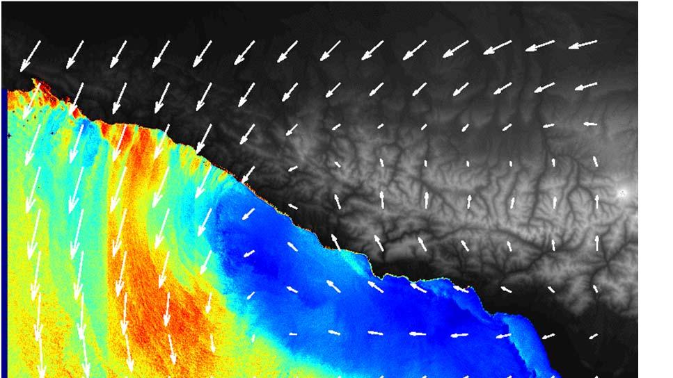
4 Example 1: Foehn wind (F) encounters an atmospheric eddy (E) 1 2 F E SAR image acquired by the ASAR onboard the Envisat satellite in the Wide Swath mode (VV polarization) at 0732 UTC 13 September 2010 over the eastern section of the Black Sea. The imaged area is 400 km x 480 km. The inset shows the location of the SAR scene. The letter E denotes the center of the atmospheric cyclonic eddy and F the wind band associated with the foehn. The other features marked by numbers are explained in the text. ESA

.")
5 Kutaisi Black Sea Kolkhida lowland Likhi ridge Topography of the Kolkhida lowland (Rioni River Basin). Google maps

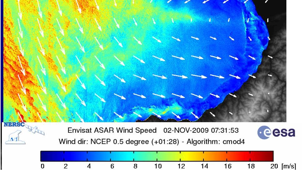
6 SAR derived wind field using the wind direction from the NCEP model


7 Doppler velocity retrieved from the SAR data Green Yellow Red colors: Wind blows to the right (in an easterly direction). Blue purple colors: Wind blows to the left (in a westerly direction).

8 SAR derived wind field by including Doppler Good!


9 Black Sea 1 2 E F Eddy MODIS Terra color composite image acquired at 0830 UTC 13 September 2010 showing in the eastern section of the Black Sea a cyclonic eddy in the cloud pattern. The inserted latitude and longitude lines have a grid spacing of 5 0 x 5 0. NASA GSFC.


10 Characteristic foehn feature: Cloud free area on the lee side of the mountain ridge Black Sea Caspian Sea Likhi Ridge Kolkhida Lowland MODIS Terra color composite image acquired at 0745 UTC 12 September 2010, approximately 24 hours before the SAR data acquisition, showing the eastern section of the Black Sea, the Caucasus area with the Kolkhida Lowland, and the western section of the Caspian Sea. The star denotes the location of the Kutaisi weather station. Note the blocking of the low level clouds by the Likhi Ridge. NASA GSFC.
11 Example 2: 16 January 2011, 1910 UTC, event Cold front over the Black Sea Ground weather map, UK Met Office 17 June 2011, 00 UTC


12 SAR image SAR derived wind field using the wind direction from the NCEP model


13 Radial surface velocity SAR derived wind field by including Doppler
14 Example 3: 21 June 2011, 0747 UTC, event Cold front over the Black Sea Ground weather map, UK Met Office 21 June 2011, 00 UTC


15 SAR image SAR derived wind field using the wind direction from the NCEP model


16 Radial surface velocity SAR derived wind field by including Doppler


17 Wind direction is a matter of debate! 00 UTC 12 UTC web site of Marine Hydrophysical Institute in Sevastopol(Ukraine)


18 Typical wind jet linked to the coastal topography Tuapse
19 Conclusions The new SAR wind retrieval algorithm including Doppler information (Mouche et al., 2012) gives, in general, better results than the algorithms using only model winds or linear features visible on SAR images. However, sometimes human intervention is needed in this automatic wind retrieval algorithms to obtain correct wind fields.
20 Thank you for your attention
HIGH RESOLUTION WIND FIELDS OVER THE BLACK SEA DERIVED FROM ENVISAT ASAR DATA USING AN ADVANCED WIND RETRIEVAL ALGORITHM
 HIGH RESOLUTION WIND FIELDS OVER THE BLACK SEA DERIVED FROM ENVISAT ASAR DATA USING AN ADVANCED WIND RETRIEVAL ALGORITHM Werner Alpers (1), Alexis Mouche (2), Andrei Yu. Ivanov (3), Burghard Brümmer (4)
STUDY OF LOCAL WINDS IN MOUNTAINOUS COASTAL AREAS BY MULTI- SENSOR SATELLITE DATA
 STUDY OF LOCAL WINDS IN MOUNTAINOUS COASTAL AREAS BY MULTI- SENSOR SATELLITE DATA Werner Alpers Institute of Oceanography, University of Hamburg, Bundesstrasse 53, D-20146 Hamburg, Germany E-mail: alpers@ifm.uni-hamburg.de
Application of a new algorithm using Doppler information to retrieve complex wind fields over the Black Sea from ENVISAT SAR images
 1 International Journal Of Remote Sensing 2015, Volume 36 Issue 3 Pages 863-881 http://dx.doi.org/10.1080/01431161.2014.999169 http://archimer.ifremer.fr/doc/00253/36390/ 2015 Taylor & Francis Achimer
Original DOI: /2008MWR2563.1
 Original Alpers, W.; Ivanov, A.; Horstmann, J.: Observations of Bora Events over the Adriatic Sea and Black Sea by Spaceborne Synthetic Aperture Radar In: Monthly Weather Review (2009) AMS DOI: 10.1175/2008MWR2563.1
Introduction EU-Norsewind
 Satellite winds in EU-Norsewind Charlotte Bay Hasager, Risø DTU, Denmark Alexis Mouche, CLS, France Merete Badger, Poul Astrup & Morten Nielsen, Risø DTU, Denmark Romain Husson, ESA Introduction EU-Norsewind
Synthetic aperture radar observations of sea surface signatures of atmospheric gravity waves over Southeast Asian coastal waters
 Synthetic aperture radar observations of sea surface signatures of atmospheric gravity waves over Southeast Asian coastal waters Werner Alpers Institute of Oceanography, University of Hamburg, Hamburg,
ON THE USE OF DOPPLER SHIFT FOR SAR WIND RETRIEVAL
 ON THE USE OF DOPPLER SHIFT FOR SAR WIND RETRIEVAL K-F. Dagestad 1, A. Mouche 2, F. Collard 2, M. W. Hansen 1 and J. Johannessen 1 (1) Nansen Environmental and Remote Censing Center, Thormohlens gt 47,
DEVELOPMENT AND VALIDATION OF A SAR WIND EMULATOR
 The Nansen Environmental and Remote Sensing Center a non-profit research institute affiliated with the University of Bergen Thormøhlensgate 47, N-5006 Bergen Norway NERSC Technical Report no. 304 DEVELOPMENT
SPATIAL AND TEMPORAL VARIATIONS OF INTERNAL WAVES IN THE NORTHERN SOUTH CHINA SEA
 SPATIAL AND TEMPORAL VARIATIONS OF INTERNAL WAVES IN THE NORTHERN SOUTH CHINA SEA Weigen Huang (1), Johnny Johannessen (2,3), Werner Alpers (4) Jingsong Yang (1), Xilin Gan (1) (1) Second Institute of
IMPROVED BAYESIAN WIND VECTOR RETRIEVAL SCHEME USING ENVISAT ASAR DATA: PRINCIPLES AND VALIDATION RESULTS
 IMPROVED BAYESIAN WIND VECTOR RETRIEVAL SCHEME USING ENVISAT ASAR DATA: PRINCIPLES AND VALIDATION RESULTS Vincent Kerbaol (1), and the SAR Ocean Wind, Waves and Currents Team (1) BOOST Technologies, 115
Development of SAR-Derived Ocean Surface Winds at NOAA/NESDIS
 Development of SAR-Derived Ocean Surface Winds at NOAA/NESDIS Pablo Clemente-Colón, William G. Pichel, NOAA/NESDIS Frank M. Monaldo, Donald R. Thompson The Johns Hopkins University Applied Physics Laboratory
THE POLARIMETRIC CHARACTERISTICS OF BOTTOM TOPOGRAPHY RELATED FEATURES ON SAR IMAGES
 THE POLARIMETRIC CHARACTERISTICS OF BOTTOM TOPOGRAPHY RELATED FEATURES ON SAR IMAGES Taerim Kim Professor, Ocean System Eng. Dept. Kunsan University Miryong Dong San 68, Kunsan, Jeonbuk, Korea, trkim@kunsan.ac.kr
Lifting satellite winds from 10 m to hub-height
 Lifting satellite winds from 10 m to hub-height Hasager, C.B., Badger, M., Peña, A., Hahmann, A., Volker, P. 23 May 2016 VindkraftNet meeting, DONG Energy, Skærbæk Motivation We have: Satellite wind maps
SAR images and Polar Lows
 SAR images and Polar Lows Gunnar Noer, Birgitte Furevik, Johannes Röhrs Observing polar lows in 2012: AVHRR Polar orbiting satellite imagery Primary source of info Observations at cloud tops Synoptic observations
The Effects of Gap Wind Induced Vorticity, the ITCZ, and Monsoon Trough on Tropical Cyclogenesis
 The Effects of Gap Wind Induced Vorticity, the ITCZ, and Monsoon Trough on Tropical Cyclogenesis Heather M. Holbach and Mark A. Bourassa Center for Ocean-Atmospheric Prediction Studies Department of Earth,
PRELIMINARY STUDY ON DEVELOPING AN L-BAND WIND RETRIEVAL MODEL FUNCTION USING ALOS/PALSAR
 PRELIMINARY STUDY ON DEVELOPING AN L-BAND WIND RETRIEVAL MODEL FUNCTION USING ALOS/PALSAR Osamu Isoguchi, Masanobu Shimada Earth Observation Research Center, Japan Aerospace Exploration Agency (JAXA) 2-1-1
Small- and large-scale circulation
 The Earth System - Atmosphere II Small- and large-scale circulation Atmospheric Circulation 1. Global atmospheric circulation can be thought of as a series of deep rivers that encircle the planet. 2. Imbedded
Surface Wave Parameters Retrieval in Coastal Seas from Spaceborne SAR Image Mode Data
 PIERS ONLINE, VOL. 4, NO. 4, 28 445 Surface Wave Parameters Retrieval in Coastal Seas from Spaceborne SAR Image Mode Data Jian Sun 1,2 and Hiroshi Kawamura 1 1 Graduate School of Science, Tohoku University,
OBSERVATIONS OF ATMOSPHERIC GRAVITY WAVES OVER THE CHINESE SEAS BY SPACEBORNE SYNTHETIC APERTURE RADAR
 OBSERVATIONS OF ATMOSPHERIC GRAVITY WAVES OVER THE CHINESE SEAS BY SPACEBORNE SYNTHETIC APERTURE RADAR W. Alpers (1), W. Huang (2), G. Xilin (2) (1) Center for Marine and Climate Research, Institute of
P2.17 OBSERVATIONS OF STRONG MOUNTAIN WAVES IN THE LEE OF THE MEDICINE BOW MOUNTAINS OF SOUTHEAST WYOMING
 P2.17 OBSERVATIONS OF STRONG MOUNTAIN WAVES IN THE LEE OF THE MEDICINE BOW MOUNTAINS OF SOUTHEAST WYOMING Larry D. Oolman 1, Jeffrey R. French 1, Samuel Haimov 1, David Leon 1, and Vanda Grubišić 2 1 University
USING SATELLITE SAR IN OFFSHORE WIND RESOURCE ASSESSMENT
 USING SATELLITE SAR IN OFFSHORE WIND RESOURCE ASSESSMENT B. R. Furevik (1), C. B. Hasager (2), M. Nielsen (2), T. Hamre (1), B. H. Jørgensen (2), O. Rathmann (2), and O. M. Johannessen (1,3) (1) Nansen
Using several data sources for offshore wind resource assessment
 Author manuscript, published in ", Copenhagen : Denmark (2005)" Ben Ticha M. B., Ranchin T., Wald L., Using several data sources for offshore wind resource assessment, 2005, Using several data sources
Synthetic Aperture Radar imaging of Polar Lows
 Oslo Polar Low workshop 21-22 May 2012 Extended abstract Synthetic Aperture Radar imaging of Polar Lows Birgitte Furevik, Gunnar Noer and Johannes Röhrs met.no Forecasting polar lows is to a large degree
Yellow Sea with contributions by John R. Apel
 with contributions by John R. Apel Overview The is a shallow inland sea lying between northeastern China and the Korean Peninsula, with depths in its central north-south trough in excess of 60 to 80 m
Wind statistics offshore based on satellite images
 Wind statistics offshore based on satellite images Charlotte Bay Hasager, Merete Badger, Poul Astrup, Morten Nielsen, Ioanna Karagali, Risø DTU Alexis Mouche, CLS, France Content Offshore sites QuikSCAT
Analyses of Scatterometer and SAR Data at the University of Hamburg
 Analyses of Scatterometer and SAR Data at the University of Hamburg Wind, Waves, Surface Films and Rain ГАДЕ, Мартин Хорстович (aka Martin Gade) Institut für Meereskunde, Universität Hamburg, Германия
Coriolis Effect Movies
 Introduction to Oceanography Lecture 16: Wind 2 Wind speed and direction about 1.5 km above sea level By Trent Schindler (NASA) using satellite data. Public Domain https://svs.gsfc.nasa.gov/4571 Coriolis
EVALUATION OF ENVISAT ASAR WAVE MODE RETRIEVAL ALGORITHMS FOR SEA-STATE FORECASTING AND WAVE CLIMATE ASSESSMENT
 EVALUATION OF ENVISAT ASAR WAVE MODE RETRIEVAL ALGORITHMS FOR SEA-STATE FORECASTING AND WAVE CLIMATE ASSESSMENT F.J. Melger ARGOSS, P.O. Box 61, 8335 ZH Vollenhove, the Netherlands, Email: info@argoss.nl
11. WIND SYSTEMS A&B: Ch 8 (p )
") 1 11. WIND SYSTEMS A&B: Ch 8 (p 214-238) Concepts: I. Scale II. Differential heating III. Wind direction 1. Scales: Three major divisions Space Time Micro meters seconds - minutes Meso kilometers seconds
1 11. WIND SYSTEMS A&B: Ch 8 (p 214-238) Concepts: I. Scale II. Differential heating III. Wind direction 1. Scales: Three major divisions Space Time Micro meters seconds - minutes Meso kilometers seconds
Xiaoli Guo Larsén,* Søren Larsen and Andrea N. Hahmann Risø National Laboratory for Sustainable Energy, Roskilde, Denmark
 Quarterly Journal of the Royal Meteorological Society Q. J. R. Meteorol. Soc. 138: 274 279, January 2012 A Notes and Correspondence Origin of the waves in A case-study of mesoscale spectra of wind and
P2.25 SUMMER-TIME THERMAL WINDS OVER ICELAND: IMPACT OF TOPOGRAPHY. Bergen
 P2.25 SUMMER-TIME THERMAL WINDS OVER ICELAND: IMPACT OF TOPOGRAPHY Haraldur Ólafsson 1 and Hálfdán Ágústsson 2 1 University of Iceland, Bergen School of Meteorology, Geophysical Institute, University of
Flow separation and lee-waves in the marine atmosphere
 Flow separation and lee-waves in the marine atmosphere Det norske Videnskabs-Akademi 16 Oct. 2009 Bjørn Gjevik Universitetet i Oslo epost: bjorng@math.uio.no Flow separation and lee-waves in the marine
An Atlas of Oceanic Internal Solitary Waves (February 2004) by Global Ocean Associates Prepared for Office of Naval Research Code 322 PO
 by Global Ocean Associates Prepared for Office of Naval Research Code 322 PO") Overview The is located in the North Atlantic Ocean between southern Ireland and southwest England (Figure 1). The Sea s western edge covers a continental shelf region characterized by rough and irregular
Overview The is located in the North Atlantic Ocean between southern Ireland and southwest England (Figure 1). The Sea s western edge covers a continental shelf region characterized by rough and irregular
HIGH RESOLUTION WIND AND WAVE MEASUREMENTS FROM TerraSAR-X IN COMPARISON TO MARINE FORECAST
 SAR Maritime Applications German Aerospace Center (DLR) Remote Sensing Technology Institute Maritime Security Lab HIGH RESOLUTION WIND AND WAVE MEASUREMENTS FROM TerraSAR-X IN COMPARISON TO MARINE FORECAST
9/25/2014. Scales of Atmospheric Motion. Scales of Atmospheric Motion. Chapter 7: Circulation of the Atmosphere
 Chapter 7: Circulation of the Atmosphere The Atmosphere: An Introduction to Meteorology, 12 th Lutgens Tarbuck Lectures by: Heather Gallacher, Cleveland State University Scales of Atmospheric Motion Small-
Assessing the quality of Synthetic Aperture Radar (SAR) wind retrieval in coastal zones using multiple Lidars
 wind retrieval in coastal zones using multiple Lidars") Assessing the quality of Synthetic Aperture Radar (SAR) wind retrieval in coastal zones using multiple Lidars Tobias Ahsbahs Merete Badger, Ioanna Karagali, Xiaoli Larsen What is the coastal zone? Coastal
Assessing the quality of Synthetic Aperture Radar (SAR) wind retrieval in coastal zones using multiple Lidars Tobias Ahsbahs Merete Badger, Ioanna Karagali, Xiaoli Larsen What is the coastal zone? Coastal
Wind Direction Analysis over the Ocean using SAR Imagery
 Journal of Information & Computational Science 5: 1 (2008) 223-231 Available at http: www.joics.com Wind Direction Analysis over the Ocean using SAR Imagery Kaiguo Fan a,b,, Weigen Huang a, Mingxia He
Using Satellite Spectral Wave Data for Wave Energy Resource Characterization
 Using Satellite Spectral Wave Data for Wave Energy Resource Characterization M. T. ontes 1,2, M. Bruck 3, S. Lehener 3, A. Kabuth 1,4 1 LNEG Estrada do aço do Lumiar 1649-038 Lisboa, ortugal teresa.pontes@lneg.pt
The Sea surface KInematics Multiscale (SKIM)
") The Sea surface KInematics Multiscale () proposal for ESA EE9 the team : https://www.facebook.com/4ee9 http://tinyurl.com/onrg http://www.umr-lops.fr/projets/projets-actifs/ 14 years of Doppler oceanography:
The Sea surface KInematics Multiscale () proposal for ESA EE9 the team : https://www.facebook.com/4ee9 http://tinyurl.com/onrg http://www.umr-lops.fr/projets/projets-actifs/ 14 years of Doppler oceanography:
OBSERVATION OF HURRICANE WINDS USING SYNTHETIC APERTURE RADAR
 OBSERVATION OF HURRICANE WINDS USING SYNTHETIC APERTURE RADAR Jochen Horstmann 1, Wolfgang Koch 1,DonaldR.Thompson 2, and Hans C. Graber 3 1 Institute for Coastal Research, GKSS Research Center, Geesthacht,
ADVANCES ON WIND ENERGY RESOURCE MAPPING FROM SAR
 ADVANCES ON WIND ENERGY RESOURCE MAPPING FROM SAR C.B. Hasager, M. Nielsen, M.B. Christiansen, R. Barthelmie, P. Astrup Risoe National Laboratory, Wind Energy Department, Frederiksborgvej 399, DK-4000
Analyzing Surface Wind Fields Near Lower Cook Inlet And Kodiak Waters Using SAR
 J4.11 Analyzing Surface Wind Fields Near Lower Cook Inlet And Kodiak Waters Using SAR Eddie Zingone Weather Forecast Office, National Weather Service, Anchorage Alaska Gary L. Hufford Alaska Region Headquarters,
Enviro Sci 1A03 Quiz 3
 Enviro Sci 1A03 Quiz 3 Question 1 (1 point) Which of the following measure wind direction and speed? Question 1 options: a) aerovane b) anemometer c) wind vane d) all of the above Question 2 (1 point)
FUSION OF SYNTHETIC APERTURE RADAR AND OPTICAL SATELLITE DATA FOR UNDERWATER TOPOGRAPHY ESTIMATION IN COASTAL AREAS
 FUSION OF SYNTHETIC APERTURE RADAR AND OPTICAL SATELLITE DATA FOR UNDERWATER TOPOGRAPHY ESTIMATION IN COASTAL AREAS Andrey L. Pleskachevsky (1), Susanne Lehner (1) (1) German Aerospace Centre (DLR), Remote
ERS WAVE MISSION REPROCESSING- QC SUPPORT ENVISAT MISSION EXTENSION SUPPORT
 REPORT 8/2011 ISBN 978-82-7492-248-8 ISSN 1890-5218 ERS WAVE MISSION REPROCESSING- QC SUPPORT ENVISAT MISSION EXTENSION SUPPORT - Annual Report 2010 Author (s): Harald Johnsen (Norut), Fabrice Collard
Central American Pacific Coast
 Overview The Pacific coast of Central America extends approximately 3700 km from central Mexico (20 o N, 106 o W) to the edge of South America (7 o N, 78 o W). A significant continental shelf exists from
Sentinel-1A Ocean Level-2 Products Validation Strategy
 Sentinel-1A Ocean Level-2 Products Validation Strategy Sentinel-1 Mission Performance Centre ESL L2 Team and Ocean Data Lab G.Hajduch (1), A.Mouche (2), P.Vincent (1), R.Husson (1), H.Johnsen (3), F.Collard
3 Global Winds and Local Winds
 CHAPTER 15 3 Global Winds and Local Winds SECTION The Atmosphere BEFORE YOU READ After you read this section, you should be able to answer these questions: What causes wind? What is the Coriolis effect?
3 Global Winds and Local Winds
 CHAPTER 6 3 Global Winds and Local Winds SECTION The Atmosphere BEFORE YOU READ After you read this section, you should be able to answer these questions: What causes wind? What is the Coriolis effect?
Foundations of Earth Science, 6e Lutgens, Tarbuck, & Tasa
 Foundations of Earth Science, 6e Lutgens, Tarbuck, & Tasa The Atmosphere in Motion Foundations, 6e - Chapter 13 Stan Hatfield Southwestern Illinois College Atmospheric pressure Force exerted by the weight
Chapter 7: Circulation And The Atmosphere
 Chapter 7: Circulation And The Atmosphere Highly integrated wind system Main Circulation Currents: series of deep rivers of air encircling the planet Various perturbations or vortices (hurricanes, tornados,
Lecture Outlines PowerPoint. Chapter 18 Earth Science 11e Tarbuck/Lutgens
 Lecture Outlines PowerPoint Chapter 18 Earth Science 11e Tarbuck/Lutgens 2006 Pearson Prentice Hall This work is protected by United States copyright laws and is provided solely for the use of instructors
High resolution wind retrieval for SeaWinds
 High resolution wind retrieval for SeaWinds David G. Long and Jeremy B. Luke Brigham Young University, 459 Clyde Building, Provo, UT 84602, USA ABSTRACT The SeaWinds instrument on the QuikSCAT satellite
Evaluation of MODIS chlorophyll algorithms in
 Evaluation of MODIS chlorophyll algorithms in Australian continental shelf waters: The IMOS match up data base Schroeder T, Lovell J,, Clementson L, King E, Brando V 9 July 2014 Australian Marine Science
Warm-up. color mass. albedo. mirage
 Warm-up Page: 523, 1. The amount of solar energy reflected or absorbed depends on the, texture, composition, volume,, transparency and other properties. color mass Page: 523, 2. The fraction of solar radiation
8 th Grade Science Meteorology Review
 8 th Grade Science Meteorology Review #1 Where does Earth get the energy that produces global weather patterns? A: The sun B: Humidity C: Air masses D: Cyclones A. The Sun #2 Do all of the areas on Earth
Local and Global Winds
 PART 2 Wind Local and Global Winds Wind is the horizontal movement of air. All wind is caused by air pressure differences due to the uneven heating of Earth's surface, which sets convection currents in
Climate & Earth System Science. Introduction to Meteorology & Climate. Chapter 07. Lecture 14. Global Scale Winds. Simple Introductory Examples:
 Climate & Earth System Science Introduction to Meteorology & Climate MAPH 10050 Peter Lynch Peter Lynch Meteorology & Climate Centre School of Mathematical Sciences University College Dublin Meteorology
Seasonal and interannual variation of currents in the western Japan Sea: numerical simulation in comparison with infrared satellite imagery
 Seasonal and interannual variation of currents in the western Japan Sea: numerical simulation in comparison with infrared satellite imagery Olga Trusenkova*, Aleksandr Nikitin**, Vyacheslav Lobanov*, and
830 IEEE TRANSACTIONS ON GEOSCIENCE AND REMOTE SENSING, VOL. 48, NO. 2, FEBRUARY /$ IEEE
 830 IEEE TRANSACTIONS ON GEOSCIENCE AND REMOTE SENSING, VOL. 48, NO. 2, FEBRUARY 2010 Investigation of Ocean Surface Wave Refraction Using TerraSAR-X Data Xiaoming Li, Susanne Lehner, and Wolfgang Rosenthal
Characterization of Boundary-Layer Meteorology During DISCOVER-AQ
 Characterization of Boundary-Layer Meteorology During DISCOVER-AQ Daniel M. Alrick and Clinton P. MacDonald Sonoma Technology, Inc. Gary A. Morris St. Edward s University for Texas Air Quality Research
Monitoring Conditions Offshore with Satellites
 Downloaded from orbit.dtu.dk on: Dec 15, 2017 Monitoring Conditions Offshore with Satellites Karagali, Ioanna; Hasager, Charlotte Bay; Badger, Merete; Bingöl, Ferhat; Ejsing Jørgensen, Hans Publication
Sea Surface Temperature (SST) in South China Sea Retrieved from Chinese Satellite FY-3B VIRR Data
 in South China Sea Retrieved from Chinese Satellite FY-3B VIRR Data") Sea Surface Temperature (SST) in South China Sea Retrieved from Chinese Satellite FY-3B VIRR Data Chuqun CHEN*, Quanjun HE, Shilin TANG, Haibin YE State key Lab of Tropical Oceanography, South China Sea
Sea Surface Temperature (SST) in South China Sea Retrieved from Chinese Satellite FY-3B VIRR Data Chuqun CHEN*, Quanjun HE, Shilin TANG, Haibin YE State key Lab of Tropical Oceanography, South China Sea
Oceans and the Global Environment: Lec 2 taking physics and chemistry outdoors. the flowing, waving ocean
 Oceans and the Global Environment: Lec 2 taking physics and chemistry outdoors the flowing, waving ocean Peter Rhines 1 Eric Lindahl 2 Bob Koon 2, Julie Wright 3 www.ocean.washington.edu/courses/has221a-08
JOURNAL OF GEOPHYSICAL RESEARCH. M. R. Cape, Department of Physical Oceanography, Woods Hole
 JOURNAL OF GEOPHYSICAL RESEARCH Supporting Information for Foehn winds link climate-driven warming to ice shelf evolution in Antarctica M. R. Cape, 1,2 Maria Vernet, 1 Pedro Skvarca, 3 Sebastián Marinsek
SEA SURFACE TEMPERATURE RETRIEVAL USING TRMM MICROWAVE IMAGER SATELLITE DATA IN THE SOUTH CHINA SEA
 SEA SURFACE TEMPERATURE RETRIEVAL USING TRMM MICROWAVE IMAGER SATELLITE DATA IN THE SOUTH CHINA SEA Mohd Ibrahim Seeni Mohd and Mohd Nadzri Md. Reba Faculty of Geoinformation Science and Engineering Universiti
Ocean Wave Parameters Retrieval from TerraSAR-X Images Validated against Buoy Measurements and Model Results
 Remote Sens. 2015, 7, 12815-12828; doi:10.3390/rs71012815 Article OPEN ACCESS remote sensing ISSN 2072-4292 www.mdpi.com/journal/remotesensing Ocean Wave Parameters Retrieval from TerraSAR-X Images Validated
OCEAN vector winds from the SeaWinds instrument have
 IEEE GEOSCIENCE AND REMOTE SENSING LETTERS, VOL. 6, NO. 3, JULY 2009 413 Coastal Validation of Ultra-High Resolution Wind Vector Retrieval From QuikSCAT in the Gulf of Maine A. M. Plagge, Student Member,
NONLINEAR INTERNAL WAVES IN THE SOUTH CHINA SEA
 25 th ACRS 2004 Chiang Mai, Thailand xxx NONLINEAR INTERNAL WAVES IN THE SOUTH CHINA SEA Ming-Kuang Hsu Professor, Kuang Wu Institute of Technology, Taipei, Taiwan, R.O.C. Hsumk@kwit.edu.tw Antony K. Liu
10.2 ATMOSPHERIC ROTORS: AIRCRAFT IN SITU AND CLOUD RADAR MEASUREMENTS IN T-REX
 10.2 ATMOSPHERIC ROTORS: AIRCRAFT IN SITU AND CLOUD RADAR MEASUREMENTS IN T-REX Vanda Grubišić 1, Larry Armi 2, Joachim Kuettner 3, Samuel Haimov 4, Larry Oolman 4, Rick Damiani 4, and Brian Billings 1
Canada s vast size creates a diverse range of weather conditions and climatic conditions. Warming trend for last 10 years Wet Spring Dry five summers
 Chapter 4 Weather and Climate Canada s vast size creates a diverse range of weather conditions and climatic conditions. Weather examples: Rainy today Snow tomorrow Fog on Wednesday 23 degree C today High
Climatology of the 10-m wind along the west coast of South American from 30 years of high-resolution reanalysis
 Climatology of the 10-m wind along the west coast of South American from 30 years of high-resolution reanalysis David A. Rahn and René D. Garreaud Departamento de Geofísica, Facultad de Ciencias Físicas
ATMOSPHERIC CIRCULATION. WIND = The horizontal movement of air. Results from the differences in air pressure. Always moves from HIGH to LOW.
 ATMOSPHERIC CIRCULATION WIND = The horizontal movement of air. Results from the differences in air pressure. Always moves from HIGH to LOW. Pressure differences result from variations in temperature. AIR
Bias assessment of MODIS/MISR winds
 Bias assessment of MODIS/MISR winds Feng Lu, Yixuan Shou, Xiaohu Zhang, Jianmin Xu Office of System Development, National Satellite Meteorological Center/CMA 13th International Winds Workshop (IWW13),
Global Wind Speed Retrieval From SAR
 IEEE TRANSACTIONS ON GEOSCIENCE AND REMOTE SENSING, VOL. 41, NO. 10, OCTOBER 2003 2277 Global Wind Speed Retrieval From SAR Jochen Horstmann, Helmut Schiller, Johannes Schulz-Stellenfleth, and Susanne
Polar storms and polar jets: Mesoscale weather systems in the Arctic & Antarctic
 Polar storms and polar jets: Mesoscale weather systems in the Arctic & Antarctic Ian Renfrew School of Environmental Sciences, University of East Anglia ECMWF-WWRP/Thorpex Polar Prediction Workshop 24-27
Air Pressure and Wind
 Air Pressure and Wind 19.1 Understanding Air Pressure Air Pressure Defined Air pressure is the pressure exerted by the weight of air. Air pressure is exerted in all directions down, up, and sideways. The
Impact of fine-scale wind stress curl structures on coastal upwelling dynamics : The Benguela system as a case of study.
 IOVWST Meeting May 21, 2015, Portland (OR) Impact of fine-scale wind stress curl structures on coastal upwelling dynamics : The Benguela system as a case of study. Fabien Desbiolles1,2, Bruno Blanke1,
OPERATIONAL USE OF A WIND PROFILER FOR AVIATION METEOROLOGY ABSTRACT
 OPERATIONAL USE OF A WIND PROFILER FOR AVIATION METEOROLOGY Miguel Angel Pelacho, Darío Cano, Eugenio Ayensa Spanish Agency of Meteorology (AEMET) Parque del Buen Retiro, Apdo. 285, 28080-MADRID E-mail:
Global observations of stratospheric gravity. comparisons with an atmospheric general circulation model
 Global observations of stratospheric gravity waves made with COSMIC GPS RO and comparisons with an atmospheric general circulation model S. P. Alexander 1, T. Tsuda 2, Y. Kawatani 3, M. Takahashi 4, K.
13.6 AIRBORNE RADAR OBSERVATIONS OF BREAKING WAVES/ROTORS IN THE LEE OF THE MEDICINE BOW MOUNTAINS IN SE WYOMING, USA
 13.6 AIRBORNE RADAR OBSERVATIONS OF BREAKING WAVES/ROTORS IN THE LEE OF THE MEDICINE BOW MOUNTAINS IN SE WYOMING, USA Jeffrey R. French 1 *, Samuel Haimov 1, Larry Oolman 1, Vanda Grubišić 2, and Dave
Scales of Atmospheric Motion
 Lecture 12 Local Wind Systems Scales of Atmospheric Motion Small turbulent eddies (swirls) A synoptic eddy 1 Coriolis Effect The larger the scale, the longer the life time. Wind shear and turbulent eddy
ASSESSMENT OF SEA BREEZE CHARACTERISTICS FROM SODAR ECHOGRAMS
 ASSESSMENT OF SEA BREEZE CHARACTERISTICS FROM SODAR ECHOGRAMS SUNEETHA RANI. JUPUDI Prof. M. PURNACHANDRA RAO Department of Physics, Andhra University, Visakhapatnam, India. ABSTRACT The SODAR echograms
ERS-1/2 Scatterometer new products: mission reprocessing and data quality improvement
 ERS-1/2 Scatterometer new products: mission reprocessing and data quality improvement Giovanna De Chiara (1), Raffaele Crapolicchio (1), Pascal Lecomte (2) (1) Serco SpA Via Sciadonna 22-24 Frascati (Roma),
5 g solar powered satellite transmitter. Database = Web of Science, terms = satellite & remote sensing & habitat
 Rob Suryan 5 g solar powered satellite transmitter Database = Web of Science, terms = satellite & remote sensing & habitat Words in Abstracts From 120 Bird and Mammal Satellite Habitat Use Papers 2006-2016
Eastern Equatorial Pacific
 Overview The is the region of open ocean directly south of Mexico and Central America (between approximately 4 o to 16 o N, and 85 o to 105 o W) (Figure 1). Major bathymetric features include Guatemala
Chapter. Air Pressure and Wind
 Chapter Air Pressure and Wind 19.1 Understanding Air Pressure Air Pressure Defined Air pressure is the pressure exerted by the weight of air. 19.1 Understanding Air Pressure Air Pressure Defined Air pressure
Chapter 13 Lecture Outline. The Atmosphere in Motion
 Chapter 13 Lecture Outline The Atmosphere in Motion Understanding Air Pressure Air pressure is the force exerted by weight of air above Weight of the air at sea level 14.7 psi or 1 kg/cm 2 Decreases with
Section 3: Atmospheric Circulation
 Section 3: Atmospheric Circulation Preview Key Ideas The Coriolis Effect Global Winds Local Winds Maps in Action Key Ideas Explain the Coriolis effect. Describe the global patterns of air circulation,
ATOMOSPERIC PRESSURE, WIND & CIRCULATION
 ATOMOSPERIC PRESSURE, WIND & CIRCULATION A. INTRODUCTION Important because: pressure patterns drive wind patterns which in turn drive oceanic circulation patterns o atmospheric & oceanic circulation: major
J4.2 AUTOMATED DETECTION OF GAP WIND AND OCEAN UPWELLING EVENTS IN CENTRAL AMERICAN GULF REGIONS
 J4.2 AUTOMATED DETECTION OF GAP WIND AND OCEAN UPWELLING EVENTS IN CENTRAL AMERICAN GULF REGIONS Xiang Li*, University of Alabama in Huntsville Huntsville, AL D. K. Smith Remote Sensing Systems Santa Rosa,
Offshore wind mapping Mediterranean area using SAR
 Downloaded from orbit.dtu.dk on: Jan 12, 2019 Offshore wind mapping Mediterranean area using SAR Calaudi, Rosamaria; Arena, Felice; Badger, Merete; Sempreviva, Anna Maria Published in: Energy Procedia
Global Winds and Local Winds
 Global Winds and Local Winds National Science Education Standards ES 1j What is the Coriolis effect? What are the major global wind systems on Earth? What Causes Wind? Wind is moving air caused by differences
Wind Atlas for the Gulf of Suez Satellite Imagery and Analyses
 Downloaded from orbit.dtu.dk on: Nov 09, 2017 Wind Atlas for the Gulf of Suez Satellite Imagery and Analyses Hasager, Charlotte Bay Publication date: 2003 Document Version Publisher's PDF, also known as
Variability of surface transport in the Northern Adriatic Sea from Finite-Size Lyapunov Exponents" Maristella Berta
 Variability of surface transport in the Northern Adriatic Sea from Finite-Size Lyapunov Exponents" Maristella Berta Marseille, 29 November 2011 Outline Geographical setting (winds and circulation of Adriatic
Summary of Lecture 10, 04 March 2008 Introduce the Hadley circulation and examine global weather patterns. Discuss jet stream dynamics jet streams
 Summary of Lecture 10, 04 March 2008 Introduce the Hadley circulation and examine global weather patterns. Discuss jet stream dynamics jet streams arise because the Coriolis force prevents Hadley-type
McKnight's Physical Geography 11e
 Chapter 2 Lecture McKnight's Physical Geography 11e Lectures Chapter 5 Atmospheric Pressure and Wind Michael Commons Ohio Northern University Atmospheric Pressure and Wind The Nature of Atmospheric Pressure
In comparison to depressions, these can be quite boring, at least in terms of the weather they bring.
 Anticyclones In comparison to depressions, these can be quite boring, at least in terms of the weather they bring. In summary, anticyclones; Are larger than low pressure systems, Last longer than low pressure
6.9B verify through investigations that thermal energy moves in a predictable pattern from warmer to cooler 6.5B recognize that a limited number of
 6.9B verify through investigations that thermal energy moves in a predictable pattern from warmer to cooler 6.5B recognize that a limited number of elements comprise the largest portion of oceans and atmosphere
3 Global Winds and Local Winds
 CHAPTER 1 3 Global Winds and Local Winds SECTION The Atmosphere BEFORE YOU READ After you read this section, you should be able to answer these questions: What causes wind? What is the Coriolis effect?