The 22 nd Annual Dr. Feinberg Geography Challenge Study Book. Grades 3 and 4. Spring 2017
|
|
|
- Kellie Mason
- 5 years ago
- Views:
Transcription
1 The 22 nd Annual Dr. Feinberg Geography Challenge Study Book Grades 3 and 4 Spring 2017 Mary Lee Burbank School 266 School Street Belmont, Massachusetts U.S.A. Dr. Tricia Clifford, Principal
2 Parents: Please review this with your child. Mary Lee Burbank School 266 School Street Belmont, MA March 2017 Dear Burbank Grade 3 and 4 Students: The Dr. Feinberg Geography Challenge for the Senior Division (Students in Grades 3 and 4) will take place on the morning of Friday, March 24 th, from 9:00-10:00A.M. Your parents or guardians, grandparents and special friends or neighbors are welcome to attend the Challenge. All of the questions and answers for the Challenge are found in this book. At the Challenge your team will be asked a few of the questions in each section of the guide. We encourage you to study the questions both alone and with your teammates. All questions will be directed to your team, not to you as an individual. Don t forget to coordinate with your team on a theme or color to wear the day of the Challenge. The purpose of the Challenge is to learn and have fun. You may find that some of the questions are easiest to learn by using a map or atlas to find locations and features. If you are able to understand how locations relate to one another, you may be able to avoid simply memorizing some of the answers, and you may be better able to remember what you have learned even after the Challenge is over. Congratulations to all of you who have decided to participate in the Challenge this year! If you have any questions, please contact one of the committee chairs. Good luck! Sincerely, Clare Crawford, crawfocl@yahoo.com Kathy Collins DerKazarian, kaceycoll@yahoo.com Elizabeth Dustin, eadustin@netscape.net Aida Parnagian, aida0519@yahoo.com PTA Geography Challenge Co-Chairs
3 The World Dr. Feinberg Geography Challenge 2017 Grades 3 & 4 1. Q: Which country borders the United States to the south? A: Mexico 2. Q: Tierra del Fuego is an island chain that is separated from South America by what narrow passage of water? A: The Strait of Magellan 3. Q: Name the body of water that borders the Arabian Peninsula on its east and Africa on its west. A: The Red Sea 4. Q: The Suez Canal, which connects the Mediterranean Sea with the Red Sea, runs through which country? A: Egypt 5. Q: What large island nation lies off the coast of India? A: Sri Lanka 6. Q: The Pampas are flat, fertile plains located mostly in Argentina and Uruguay. On which continent are the Pampas located? A: South America 7. Q: The Great Barrier Reef is a chain of coral reefs on which continent? A: Australia 8. Q: The Himalayas are the world s highest mountain range. Name two of the five countries in which they are located. A: China, India, Pakistan, Nepal, Bhutan 9. Q: Which continent is crossed by every line of longitude? A: Antarctica 10. Q: If you traveled along the Equator, what countries in South America would you pass through? A: Ecuador, Colombia, Brazil 11. Q: The Amazon River starts in the Andes Mountains in Peru and generally flows east. Into what ocean does it empty? A: Atlantic 12. Q: What ocean forms the Kenyan coastline? A: Indian
4 13. Q: What island is named for its location nearly halfway between North America and Asia, and halfway around the world from Greenwich, England? A: Midway 14. Q: About how far is it in miles from Belmont to the Equator if you fly the shortest route? A: About 4,800 kilometers or 2,900 miles 15. Q: The capital of Ecuador sits directly on the equator. What is it? A: Quito 16. Q: The Ring of Fire is the name for an area where volcanic eruptions and earthquakes happen frequently. Around the edge of which ocean is the Ring of Fire located? A: The Pacific Ocean 17. Q: What is the largest of the Greek islands by area? A: Crete 18. Q: The tallest waterfall in the world is called Angel Falls, dropping a whopping 3,212 feet. In what country is this waterfall located? A: Venezuela 19. Q: What country is bordered by Afghanistan and Iran in the west, India in the east and China in the far northeast? A: Pakistan The United States 20. Q: Name the two states that are not part of the continental United States? A: Hawaii and Alaska 21. Q: In which state is the Grand Canyon located? A: Arizona 22. Q: The city of Chicago sits on the coast of which Great Lake? A: Lake Michigan 23. Q: Mount Rushmore National Memorial includes sculptures of the heads of George Washington, Thomas Jefferson, Theodore Roosevelt and Abraham Lincoln. In which state is it located? A: South Dakota 24. Q: The Appalachian Trail is the longest continuous trail in the world. In which states does it begin and end? A: Maine and Georgia 25. Q: The lowest point in the United States is Death Valley. In which state is it located? A: California
5 26. Q: Which river creates the border between Illinois and Missouri? A: Mississippi River 27. Q: The Four Corners is a name given to a location in the United States where you can stand in four states at the same time. Name three of the four states. A: Colorado, New Mexico, Arizona and Utah 28. Q: What mountain range is considered the dividing line between the Eastern seaboard and the Midwest? A: The Appalachian Region 29. Q: What state is known as the Granite State? A: New Hampshire 30. Q: When it is 2pm in Boston what time is it in San Francisco? A: 11AM 31. Q: In which state is the geographic center of the continental United States? A: Kansas 32. Q: Which two states surround the Chesapeake Bay, the nation s largest estuary? A: Maryland and Virginia New England and Massachusetts 33. Q: What was the name of the colony started by the Pilgrims? A: Plymouth Bay Colony 34. Q: Name the large bay that creates the shoreline for the state of Rhode Island. A: Narragansett 35. Q: In which Massachusetts town did the Puritans first settle? A: Salem 36. Q: New England is made up of six states. Name any three of the six states and their capitals. (Note: State abbreviations may be used when answering this question.) A: Hartford, Connecticut (CT); Augusta, Maine (ME); Boston, Massachusetts (MA); Concord, New Hampshire (NH); Providence, Rhode Island (RI); and Montpelier, Vermont (VT) 37. Q: The highest peak in the northeast, this mountain is famous for its treacherous weather. A: Mt. Washington
6 38. Q: Paul Revere started his midnight ride on the night of April 18-19, 1775, in Boston. He was riding to warn the colonial militia that the British troops had landed in Boston harbor. What Massachusetts town was he riding to? A: Lexington 39. Q: In which state is the easternmost point of the continental United States? A: Maine 40. Q: Long regarded as the symbol of New Hampshire, this natural rock formation crumbled several years ago. A: The Old Man of the Mountain 41. Q: Which non-new England state borders Massachusetts to the west? A: New York 42. Q: What is the nickname of the state of Massachusetts? A: The Bay State 43. Q: New England includes three of the four most densely populated states in the United States. Name these three states. A: Rhode Island, Massachusetts, and Connecticut Belmont 44. Q: Belmont took its name from a mansion in Cushing Square named Bellmont. What does the word Belmont mean? A: Beautiful Mountain 45. Q: Belmont has three major commercial areas where people dine, shop and eat. Name them. A: Belmont Center, Cushing Square, and Waverly Square 46. Q: About how many square miles are occupied by the Town of Belmont? A: Q: Belmont is approximately how many miles northwest of Boston? A: 7 Miles 48. Q: In what year was the Town of Belmont founded? A: Q: Name one of two roads that form part of the boundary between Cambridge and Belmont. A: Blanchard Road, Grove Street
7 Geographical Terms 50. Q: What do we call the flat area that may form at the mouth of a river where it flows into a larger body of water? A: delta 51. Q: What is the latitude, measured in degrees, at the equator? A: 0 degrees 52. Q: Panama is a good example of a strip of land that connects two land masses surrounded by sea on either side. What is this geographical feature called? A: isthmus 53. Q: Usually formed by water erosion, narrow channels form in the mountainside. What are these channels called? A: gully 54. Q: What do we call the imaginary point at each end of the earth s axis? A: a pole 55. Q: A shallow pool of salt water that is near the coast, it is usually cut off from the sea by a ridge of land and is a great place for swimming. What is it called? A: a lagoon 56. Q: What is a pointed piece of land that sticks out into a sea, ocean, lake or river? A: a cape 57. Q: What is that part of the river called where the salt water of the sea meets the fresh water of the river? A: estuary 58. Q: What is a body of water that is partially enclosed by land (and usually smaller than a gulf)? A: a bay 59. Q: What does a cartographer do? A: make maps Bonus Question Q: Who is Dr. Feinberg and why is the Geography Challenge named after her? A: She was the previous Principal of the Burbank school and she started the Geography Challenge more than 20 years ago.


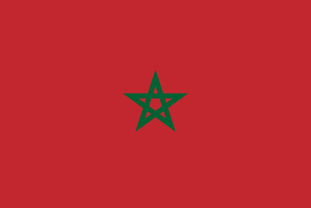
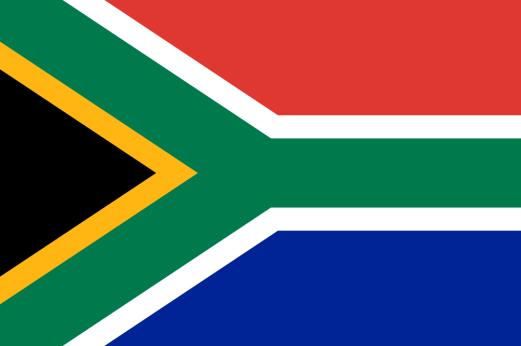
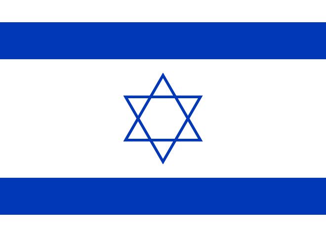
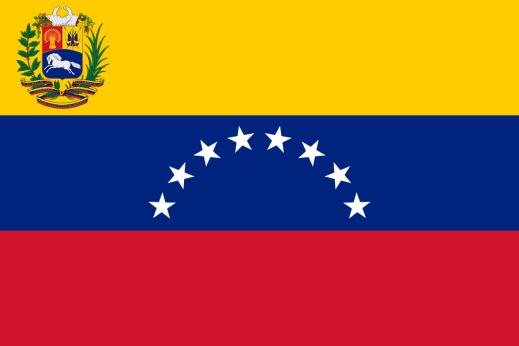
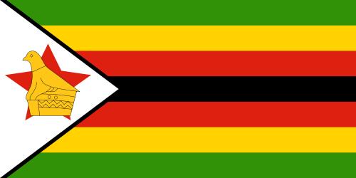
8 FLAGS Identify these flags: Australia: Israel: Barbados: Lithuania: Morocco: Venezuela: South Africa: Zimbabwe:
The 21 st Annual Dr. Feinberg Geography Challenge Study Book Grade 3 and 4 Spring 2016
 The 21 st Annual Dr. Feinberg Geography Challenge Study Book Grade 3 and 4 Spring 2016 Mary Lee Burbank School 266 School Street Belmont, Massachusetts 02478 U.S.A. Dr. Tricia Clifford, Principal Parents:
The 24 th Annual Dr. Feinberg Geography Challenge Study Book Grade 3 and 4 Spring 2019
 The 24 th Annual Dr. Feinberg Geography Challenge Study Book Grade 3 and 4 Spring 2019 Mary Lee Burbank School 266 School Street Belmont, Massachusetts 02478 U.S.A. Dr. Tricia Clifford, Principal Parents:
The 21 st Annual Dr. Feinberg Geography Challenge Study Book. Grade 1. Spring 2016
 The 21 st Annual Dr. Feinberg Geography Challenge Study Book Grade 1 Spring 2016 Mary Lee Burbank School 266 School Street Belmont, Massachusetts 02478 U.S.A. Dr. Tricia Clifford, Principal Parents: Please
The Dr. Feinberg Geography Challenge Study Guide. Grade 3 and 4. Spring 2012
 The Dr. Feinberg Geography Challenge Study Guide Grade 3 and 4 Spring 2012 Mary Lee Burbank School 266 School Street Belmont, Massachusetts 02478 U.S.A. Dr. Tricia Clifford, Principal Parents: Please review
Geography Week Which continent is your state closest to: Asia, South America, or Europe?
 Geography Week 24 1. Which continent is your state closest to: Asia, South America, or Europe? 2. Which state would have the coolest weather: Montana, Georgia, or Oklahoma? 3. What are the only two continents
Draw a picture of a water source. Don t forget to include yourself in the picture!
 Name Date Draw a picture of a water source. Don t forget to include yourself in the picture! My water source is Students describe the characteristics of a water source: stream, river, lake, pond, ocean,
DESCRIPTION NATIONAL FLAGS:
 United States Flags FLAG Size FABRIC DESCRIPTION NATIONAL FLAGS: American 2' x 3' Cotton 50 Printed Stars with flag kit American 2.5' x 4' Cotton 48 Appliqued Stars American 2' x 3' Nylon 50 Embroidered
HANDICAP ACTIVE AND INACTIVE SEASON SCHEDULE
 HANDICAP ACTIVE AND INACTIVE SEASON SCHEDULE The authorized golf association having jurisdiction in an area is responsible for declaring the duration of any inactive season. Any non-member club of an authorized
TABLE C: STATE MANDATES AND FUNDING LEVELS
 TABLE C: STATE MANDATES AND FUNDING LEVELS Information was collected from the 2012-2013 State of the States in Gifted Education report. Empty cells indicate no response to the question Hatched cells indicate
The Land Where Continents Collided. Physical Geography and Climate of South Asia
 The Land Where Continents Collided Physical Geography and Climate of South Asia South Asia Countries include: 1. Pakistan 2. India 3. Nepal 4. Bhutan 1 2 3 5 4 5. Bangladesh 6. Sri Lanka 7. Maldives 7
States. Postal Abbreviations LEARN THE. AND. by Joy A. Miller
 1 States LEARN THE AND Postal Abbreviations by Joy A. Miller http://fivejs.com Learn the States and Postal Abbreviations Copyright 2009 Published by Joy A. Miller http://fivejs.com All rights reserved.
Ocean Currents Shortcut method by to learn faster
 Ocean Currents Shortcut method by to learn faster In our geography notes on the hydrosphere, we have seen the major movements of the ocean water. They are waves, tides and ocean currents. Having covered
Ocean Currents Shortcut method by to learn faster
 Ocean Currents Shortcut method by to learn faster In our geography notes on the hydrosphere, we have seen the major movements of the ocean water. They are waves, tides and ocean currents. Having covered
Module 2 Narration What is a watershed?
 Module 2 Narration What is a watershed? Timing Key Narrative Snapshots a) 00:10 Every living thing relies on water to exist. But where does our water come from? The most natural place to look is upstream
2011 National Survey of Fishing, Hunting, and Wildlife-Associated Recreation
 U.S. Fish & Wildlife Service 2011 National Survey of Fishing, Hunting, and Wildlife-Associated Recreation State Overview Issued September 2012 Preliminary Estimates 2 2011 National Survey of Fishing, Hunting,
SAUSD Common Core First Grade Unit of Study. Student Learning Journal. Exploring Our World. Name
 Exploring Our World Student Learning Journal Name SAUSD Common Core First Grade Unit of Study Songs of Higher Learning www.songsofhigherlearning.com Lesson 1 2 Continents and Ocean Song In this world,
STUDY GUIDE. Physical Features. The Land. Chapter 23, Section 1. Landforms. Rivers. Natural Resources. Terms to Know DRAWING FROM EXPERIENCE
 For use with textbook pages 569 574. The Land Terms to Know subcontinent A landmass that is large and distinct but joined to a continent (page 569) alluvial plain An area of fertile soil deposited by river
Essential Question:
 Essential Question: I CAN... Cyprus Cyprus 15 Directions: As we go through the information, you are to copy down the location and a description of each of SW Asia s important physical features.
A Comparison of Highway Construction Costs in the Midwest and Nationally
 A Comparison of Highway Construction Costs in the Midwest and Nationally March 20, 2018 Mary Craighead, AICP 1 INTRODUCTION State Departments of Transportation play a significant role in the construction
2016 River Use Statistics -by Steve Sullivan
 Grand Canyon River Office 2016 River Use Statistics -by Steve Sullivan Topics River Use Statistics Overview Commercial River Use Statistics Noncommercial River Use Statistics Noncommercial River Lottery
Regional Summit on GROWING STATE ECONOMIES Nashville, TN November 14, Global Entrepreneurship Monitor Research: Highlights. Abdul Ali, Ph.D.
 Regional Summit on GROWING STATE ECONOMIES Nashville, TN November 14, 2011 Global Entrepreneurship Monitor Research: Highlights Abdul Ali, Ph.D. 1 Babson College # 1 Entrepreneurship Undergraduate: 1995-2011
Second Year Fourth Month Activities
 National Council for Geographic Education Curriculum & Instruction Committee Geography Club Submitted by: Steve Pierce stevepierce@charter.net Second Year Fourth Month Activities Geography for Life: National
TOM NEWBY SCHOOL EXAMINATION. Answer in full sentences. Write all answers on the question paper QUESTION 1: (6)
") 1 TOM NEWBY SCHOOL EXAMINATION Subject GEOGRAPHY Examiner MR J MAREDI Date 15 JUNE 2017 Total marks 50 Session 1 Duration 1 HOUR Grade 5 Moderator MISS M ALBERTYN Special instructions/ Equipment Answer
1 TOM NEWBY SCHOOL EXAMINATION Subject GEOGRAPHY Examiner MR J MAREDI Date 15 JUNE 2017 Total marks 50 Session 1 Duration 1 HOUR Grade 5 Moderator MISS M ALBERTYN Special instructions/ Equipment Answer
Occupant Protection Laws
 Occupant rotection Laws tate Must Be in Child Restraint* Additional eat Belt Coverage* Who is Covered & Where rimary or econdary Alabama Under 6 yrs.** 6 until 15 yrs. 15+ yrs. in Alaska Under 4 yrs.**
What Country is Upstream? Conflicts that can occur because of relative position on a river
 What Country is Upstream? Conflicts that can occur because of relative position on a river The source of a river is the place where it starts - usually in hills or mountains. People who live near a river
Occupant Protection Laws
 Occupant Protection s Alabama Alaska Arizona Under 1 yr. or
 Alabama Alaska Arizona Under 1 yr. or
 Homeschool Learning Network
 WK 1 WK 2 WK 3 WK 4 Week 1 Week 2 Week 3 Kindergarten I Learn About the Globe Rivers, Lakes, Mountains The Seven Continents Week 4 Literary Terms for Kindergarten I Native Americans, Part 1 Native Americans,
Occupant Protection Laws
 Alabama Alaska Arizona ; under 5 yrs. and 20 lbs. forward-facing ; 4-8 yrs.,
and the Link between Oceans, Atmosphere, and Weather
 Geography Worksheet Instructions Using a map, atlas, or any other materials your teacher suggests, label the following on the blank map provided. 1. Label East, West, North, and South. 2. Label the following
Performance Task: World Mountains
 Performance Task: World s Teacher Directions: In this activity, students will demonstrate their understanding of world mountains using both a map and a written assignment. Ask students to annotate the
Types of Estuaries and Mixing Patterns. Mrs. Stahl Marine Science Honors
 Types of Estuaries and Mixing Patterns Mrs. Stahl Marine Science Honors Coastal Plain Form between glacial periods, when water from melting glaciers raises the sea level and floods coastal plains and low
United States Flags. Gauge: 28 sts = 4", though gauge is not critical. Use any yarn and a needle size that gives you a fabric you like.
 United States Flags by Deborah V. Gardner Materials: 1 skein each Cascade 220 Sport, 100% Peruvian wool, #9568 Twilight Blue, #8895 Christmas Red, #8505 White (8 flags can be knitted with 1skein of each
Chapter 22, Section 1 - Ocean Currents. Section Objectives
 Chapter 22, Section 1 - Ocean Currents Section Objectives Intro Surface Currents Factors Affecting Ocean Currents Global Wind Belts (you should draw and label a diagram of the global wind belts) The Coriolis
Purpose of the Efficiency Program Industry By State and Region Appendices and Limitations of Data
 Purpose of the Efficiency Program Industry By State and Region Appendices and Limitations of Data CEE collaborates with the American Gas Association (AGA) to survey and collect data in the United States
MT - GEOGRAPHY - (73) - SEMI PRELIM - II : PAPER - 6
 - SEMI PRELIM - II : PAPER - 6") 208 00 MT MT - GEOGRAPHY - (7) - SEMI PRELIM - II : PAPER - 6 Time : 2 Hours (Model Answer Paper) Max. Marks : 0 A.. Fill in the blank choosing the correct alternative : (a) The Barren Island is the only
208 00 MT MT - GEOGRAPHY - (7) - SEMI PRELIM - II : PAPER - 6 Time : 2 Hours (Model Answer Paper) Max. Marks : 0 A.. Fill in the blank choosing the correct alternative : (a) The Barren Island is the only
STUDY GUIDE. The Land. Physical Geography of Europe. Chapter 11, Section 1. Terms to Know DRAWING FROM EXPERIENCE ORGANIZING YOUR THOUGHTS
 For use with textbook pages 271 276. The Land Terms to Know dikes Large banks of earth and stone that hold back water (page 272) polder Drained area of land (page 272) glaciation The process in which glaciers
Montessori for Everyone 2013 Types of Coastlines
 Coast The coast is the part of the land that borders the sea. It is subject to constant change, as the result of the waves and deposits carried by water onto the land. Coastline The coastline is where
Texas Charter School Academic & Athletic League 2012 Annual Geography Bee
 Texas Charter School Academic & Athletic League 2012 Annual Geography Bee I. Dates The 2012 TCSAAL State Geography Bee will take place on April 14, 2012 at the State Capitol Building in Austin, Texas.
Name Date L.O: SWBAT explain what breezes, planetary winds, ocean currents & monsoons are.
 Name Date L.O: SWBAT explain what breezes, planetary winds, ocean currents & monsoons are. 1. A cool breeze is blowing toward the land from the ocean on a warm, cloudless summer day. This condition is
CLIFF PENNINGTON. Oakland A s 2012 Math Educational Program. 3 rd -5 th Grade Workbook
 CLIFF PENNINGTON Oakland A s 2012 Math Educational Program 3 rd -5 th Grade Workbook EARN 2 VOUCHERS TO A 2012 A s GAME! ELIGIBILITY Students from 1st through 8th grade are eligible to participate in the
Target Shooting by Hunters and Their Use of Shooting Ranges: 1975, 1991, and 2011
 U.S. Fish & Wildlife Service Target Shooting by Hunters and Their Use of Shooting Ranges: 1975, 1991, and 2011 Addendum to the 2011 National Survey of Fishing, Hunting, and Wildlife-Associated Recreation
Traffic Safety Facts. State Traffic Data Data. Overview
 Traffic Safety Facts 2015 Data June 2017 DOT HS 812 412 State Traffic Data Key Findings Traffic fatalities increased by 7 percent from 2014 to 2015 (32,744 to 35,092) for the United States. The fatality
Reading and Vocabulary Study Guide
 Reading and Vocabulary Study Guide Boston, Massachusetts Upper Saddle River, New Jersey The map on page 20 is based on a map by DK Cartography. Copyright by Pearson Education, Inc., publishing as Pearson
All-Time College Football Attendance (Includes all divisions and non-ncaa teams) No. Total P/G Yearly Change No. Total P/G Yearly Change Year Teams
 No. Total P/G Yearly Change No. Total P/G Yearly Change Year Teams") Attendance Records All-Time College Football Attendance... 2 All-Time NCAA Attendance... 2 Annual Conference Attendance Leaders... 4 Largest Regular-Season Crowds... 11 2010 Attendance... 11 Annual Team
Attendance Records All-Time College Football Attendance... 2 All-Time NCAA Attendance... 2 Annual Conference Attendance Leaders... 4 Largest Regular-Season Crowds... 11 2010 Attendance... 11 Annual Team
AERO Standards: c c.
 AERO Standards: 4.1.5.c. Identify cause and effect relationships in history. 4.3.5.c. Apply concepts such as location, distance, direction, scale, movement and region. Northeast plains Also known as the
Duckies have been found in Hawaii, Alaska, S. America, Scotland, Washington state and Australia as of 2012.
 Duckies have been found in Hawaii, Alaska, S. America, Scotland, Washington state and Australia as of 2012. We learned that it takes 3 years to complete one circuit of the North Pacific Gyre flow in the
Are Highways Crumbling? State Performance Summaries,
 Policy Summary 407 February 2013 Are Highways Crumbling? State Performance Summaries, 1989 2008 by David T. Hartgen, Ph.D., P.E., M. Gregory Fields and Elizabeth San José Project Director: Adrian T. Moore,
SCI-5 MES_Lamb_Oceans Exam not valid for Paper Pencil Test Sessions
 SCI-5 MES_Lamb_Oceans Exam not valid for Paper Pencil Test Sessions [Exam ID:53S2JF 1 Two children are swimming and jumping in the waves at the beach. On which part of the ocean are they standing? A Abyssal
The Rare American Atlas
 The Rare American Atlas JEFFERYS, Thomas. The American Atlas: or, A Geographical Description of the Whole Continent of America. Wherein Are Delineated at Large, Its Several Regions, Countries, States,
Irving Marathon Sponsorship Proposal
 2018 Irving Marathon Sponsorship Proposal Table of Contents What is the Irving Marathon?... 3 Event Demographics... 4 Vision for 2018... 4 Partnering with the Irving Marathon... 5 Title Sponsorship...
CHAPTER 6. APPENDICES
 CHAPTER 6. APPENDICES Appendix 6.1. Summary of State Regulations Pertaining to Asian Carps. Some states prohibit or restrict the possession of certain species of Asian carps. State regulations pertaining
OCEANOGRAPHY STUDY GUIDE
 OCEANOGRAPHY STUDY GUIDE Chapter 2 Section 1 1. Most abundant salt in ocean. Sodium chloride; NaCl 2. Amount of Earth covered by Water 71% 3. Four oceans: What are they? Atlantic, Pacific, Arctic, Indian
HYDROSPHERE, OCEANS AND TIDES
 HYDROSPHERE, OCEANS AND TIDES Revision 10x10learning.com 1 Chapter 12. In the Earth s Atmosphere On surface of the Earth Under the ground Hydrosphere comprises of ALL WATER Water Vapour = 0.001% Is very
NYS Coastal Waters. Water Resources of NYS: THE NATURE of the COASTAL ZONE. NYS Coastal Waters. NYS Coastal Atlas. Coastal Zone Management 10/10/2014
 Water Resources of NYS: THE NATURE of the COASTAL ZONE NYS Coastal Waters NYS is the only state to border the Atlantic Ocean and the Great Lakes (Lakes Erie and Ontario). Great Lakes shoreline: 577 miles
Local Chapter Pictorial
 APA Local Chapter Pictorial Local Chapter Pictorial Alamo Chapter of the APA Albuquerque Chapter APA of Acadiana Atlanta Chapter Birmingham Payroll Association Buffalo-Niagara Chapter Cascade Payroll Association
USA TRIATHLON MEMBERSHIP REPORT TABLE OF CONTENTS
 USA TRIATHLON MEMBERSHIP REPORT This report has been prepared by the Membership Services staff based on active memberships on December 31, 2015. Media requests can be addressed to communications@usatriathlon.org.
Magellan crosses the Atlantic Ocean
 Name: Date: Module 1, Lesson 1 Magellan crosses the Atlantic Ocean After Christopher Columbus found the New World in 1492, Spain and Portugal were eager to conquer and claim new lands. The two world powers
SIA SNOW SPORTS PARTICIPANT STUDY
 2012-2013 SIA SNOW SPORTS PARTICIPANT STUDY TABLE OF CONTENTS Section Page Number Participation Demographics 5 Gender and Age Demographics 27 Income and Education Demographics 38 Ethnic Demographics 54
AWEA State RPS Market Assessment Executive Summary
 AWEA State RPS Market Assessment 2013 Executive Summary Lead Author: John Hensley, Policy Analyst Contributions from: Emily Williams, Senior Policy Analyst Carl Levesque, clean energy communications consultant
Sears Directors' Cup Final Standings
 1 North Carolina 529.0 24.5 0 0.0 16 49.0 11 54.0 0 0 0 0 17 44.5 6 58.5 26 37.5 0.0 0 5 58.5 0 0.0 806.5 2 Stanford 507.5 40.5 36 24.5 7 58.0 1 64.0 0 0 2 63.0 2 63.0 18 47.0 0.0 0 0.0 0 0.0 0 0 0.0 786.5
Tidal energy is produced by the surge of ocean waters during the rise and fall of tides. Tidal energy is a renewable source of energy.
 Encyclopedic Entry For Educator tidal energy For the complete encyclopedic entry with media resources, visit: http://www.connectenergyed.org/education/encyclopedia/tidal-energy/ Tidal energy is produced
Chapter 12: Coasts (after a brief review of Tides)
") Chapter 12: Coasts (after a brief review of Tides) 1 Questions from previous classes: What happens when a wave meets a current? wave = people walking current = bus If wave goes with the current, the wave
Chapter 12: Coasts (after a brief review of Tides) 1 Questions from previous classes: What happens when a wave meets a current? wave = people walking current = bus If wave goes with the current, the wave
Office of Institutional Research
 ri a l C ty Consistency Sim p li c it y Office of Institutional Research Place of Residence for International Students by Gender: Published October 2012 OIR Staff: Peggy Johnson - Associate Director Miriam
Station 1: Ocean Currents Use the ocean currents map copied from page 4 of the ESRT and the passage to answer the questions that follow.
 Station 1: Ocean Currents Use the ocean currents map copied from page 4 of the ESRT and the passage to answer the questions that follow. The Map: Questions: 1. Name the cool current off the West coast
VOLUNTEER HANDBOOK. USA Swimming LSC Development Committee. Draft Copy 7/4/17
 VOLUNTEER HANDBOOK USA Swimming LSC Development Committee Draft Copy 7/4/17 TABLE OF CONTENTS 1.0 USA Swimming 1.1 USA Swimming Core Objectives 1.2 USA Swimming Cultural Values 1.3 USA Swimming Organizational
Chapter 11: Motion. How Far? How Fast? How Long?
 Chapter 11: Motion How Far? How Fast? How Long? 1. Suppose the polar bear was running on land instead of swimming. If the polar bear runs at a speed of about 8.3 m/s, how far will it travel in 10.0 hours?
KINGDOM OF CAMBODIA NATION RELIGION KING 3
 KINGDOM OF CAMBODIA NATION RELIGION KING 3 TOURISM STATISTICS REPORT February 2018 MINISTRY OF TOURISM Statistics and Tourism Information Department No. A3, Street 169, Sangkat Veal Vong, Khan 7 Makara,
Wind Trends Bulletin. Q Global Wind Anomalies. wind speed anomalies
 Q4 2013 - Global Wind Anomalies In the final quarter of 2013, winds were generally below normal relative to the long-term fourth quarter average (1988 2012) across western North America, Central America,
California By Michael Stahl
 California California By Michael Stahl California is the third largest state in America. Only Texas and Alaska have greater areas of landmass than California. However, the Golden State, as it is sometimes
Education Committee Economic Background and Issue Review
 Education Committee Economic Background and Issue Review Montpelier, Vermont January 22, 2014 Thomas E. Kavet State Economist and Principal Economic Advisor to the Vermont State Legislature Since 1996
Full-Time Visa Enrolment by Countries
 Page 1 of 32 All Students Afghanistan Albania Algeria Andorra Antigua Argentina Armenia Australia Austria Azerbaidjan Bahamas Bahrain Bangladesh Barbados Belarus Belgium Belize Benin (Dahomey) Bermuda
APA Local Chapter Pictorial
 APA Local Chapter Pictorial Alamo Chapter of the APA Albuquerque Chapter APA of Acadiana Atlanta Chapter Broward County Association of Payroll Professionals Buffalo-Niagara Chapter Cascade Payroll Association
Chapter 8 Air Masses
 Chapter 8 Air Masses Air Masses - 1 1. An Air Mass is a large body of air usually about 1500 km across and several km thick, that has homogeneous physical properties. 2. The important physical properties
New Hampshire Live Free or Die Jul 10, 2013 ( ) Jerry D. Petersen
 Jerry D. Petersen") New Hampshire Live Free or Die Jul 10, 2013 (163-2013-13) Jerry D. Petersen New Hampshire? Well, yes. I was thinking (again) about the states that I have never been to in all my travels around this beautiful
New Hampshire Live Free or Die Jul 10, 2013 (163-2013-13) Jerry D. Petersen New Hampshire? Well, yes. I was thinking (again) about the states that I have never been to in all my travels around this beautiful
AKRON, UNIVERSITY OF $16,388 $25,980 $10,447 $16,522 $14,196 $14,196 $14,196 ALABAMA, UNIVERSITY OF $9,736 $19,902 N/A N/A $14,464 $14,464 $14,464
 AKRON, UNIVERSITY OF $16,388 $25,980 $10,447 $16,522 $14,196 $14,196 $14,196 ALABAMA, UNIVERSITY OF $9,736 $19,902 N/A N/A $14,464 $14,464 $14,464 ALBANY LAW SCHOOL OF UNION UNIVERSITY $35,079 $35,079
TO GO TO ANY OF THE PAGES LISTED BELOW, CLICK ON ITS TITLE
 TO GO TO ANY OF THE PAGES LISTED BELOW, CLICK ON ITS TITLE CHAPTER 10 The Oceans 1 10-1 What is the world ocean? 2 10-2 How are the oceans explored? 3 Measuring Ocean Properties Enrichment Activity for
Catena Media analysis of how we expect sports betting to roll out across the United States of America.
 Catena Media analysis of how we expect sports betting to roll out across the United States of America. The impacts of this ruling on sports betting in the United States The state of New Jersey can now
Folder 1 Weeks 1-9. Folder 2 Weeks 10-18
 This guide shows where to place the mini-booklets in each folder. Folder 1 s 1-9 1 3 5 8 2 4 9 6 Folder 2 s 10-18 10 12 15 17 13 11 16 18 This guide shows where to place the mini-booklets in each folder.
Ocean Currents Unit (4 pts)
") Name: Section: Ocean Currents Unit (Topic 9A-1) page 1 Ocean Currents Unit (4 pts) Ocean Currents An ocean current is like a river in the ocean: water is flowing traveling from place to place. Historically,
Name: Section: Ocean Currents Unit (Topic 9A-1) page 1 Ocean Currents Unit (4 pts) Ocean Currents An ocean current is like a river in the ocean: water is flowing traveling from place to place. Historically,
WIND SPEED LENGTH OF TIME WIND BLOWS (Duration) DISTANCE OVER WHICH IT BLOWS (Fetch)
 DISTANCE OVER WHICH IT BLOWS (Fetch)") WAVES Up and down movement of ocean surface Transportation of energy across the water over vast distances If not stopped by anything, waves can travel entire oceans Size and speed depend upon: WIND SPEED
WAVES Up and down movement of ocean surface Transportation of energy across the water over vast distances If not stopped by anything, waves can travel entire oceans Size and speed depend upon: WIND SPEED
Shore - place where ocean meets land Coast - refers to the larger zone affected by the processes that occur at this boundary.
 Waves, Beaches, and Coasts Shore - place where ocean meets land Coast - refers to the larger zone affected by the processes that occur at this boundary. Waves: energy moving through water The height of
Chapter 13 Geography and the Early Settlement of India. How did geography affect early settlement in India?
 Chapter 13 Geography and the Early Settlement of India How did geography affect early settlement in India? Section 13.1 - Introduction The Art Archive / Collection Antonovich / Gianni Dagli Orti This stone
Together, we are creating a world that works better.
 Together, we are creating a world that works better. www.td.org/powermember www.td.org/membership TIPS, TOOLS & INTELLIGENCE FOR DEVELOPING TALENT HUMAN CAPITAL ISSUE 1801 Alan Landers JANUARY 2018 $19.50
INTERNATIONAL STUDENT STATISTICAL SUMMARY Spring 2017 (Final)
") INTERNATIONAL STUDENT STATISTICAL SUMMARY Spring 2017 (Final) Prepared By: Mr. Jay Ward, Associate Director Office of International Programs San Francisco State University Non-Matriculated SP 17 SP 16
INTERNATIONAL STUDENT STATISTICAL SUMMARY Spring 2017 (Final) Prepared By: Mr. Jay Ward, Associate Director Office of International Programs San Francisco State University Non-Matriculated SP 17 SP 16
Name Class Date. d = vt Step 3: Insert the known values into the equation, and solve.
 Skills Worksheet Math Skills Velocity After you study each sample problem and solution, work out the practice problems on a separate sheet of paper. Write your answers in the spaces provided. Polar bears
RESOURCE BOOKLET M13/4/ENVSO/SP2/ENG/TZ0/XX/T ENVIRONMENTAL SYSTEMS AND SOCIETIES PAPER 2. Tuesday 7 May 2013 (afternoon) 2 hours
 2 hours") M13/4/ENVSO/SP2/ENG/TZ0/XX/T 22136303 ENVIRONMENTAL SYSTEMS AND SOCIETIES Standard level PAPER 2 Tuesday 7 May 2013 (afternoon) 2 hours RESOURCE BOOKLET INSTRUCTIONS TO CANDIDATES Do not open this booklet
M13/4/ENVSO/SP2/ENG/TZ0/XX/T 22136303 ENVIRONMENTAL SYSTEMS AND SOCIETIES Standard level PAPER 2 Tuesday 7 May 2013 (afternoon) 2 hours RESOURCE BOOKLET INSTRUCTIONS TO CANDIDATES Do not open this booklet
9. The Earth's planetary winds are deflected as a result of the Earth's A) revolution around the Sun B) seasonal changes C) rotation on its axis D)
 revolution around the Sun B) seasonal changes C) rotation on its axis D)") 1. Which ocean current transports warm water away from Earth s equatorial region? A) Brazil Current B) Guinea Current C) Falkland Current D) California Current 2. The Gulf Stream and North Atlantic Current
1. Which ocean current transports warm water away from Earth s equatorial region? A) Brazil Current B) Guinea Current C) Falkland Current D) California Current 2. The Gulf Stream and North Atlantic Current
Name Class Date. Unknown: Step 2: Rearrange the speed equation to solve for distance. speed distance time
 Skills Worksheet Math Skills Velocity After you study each sample problem and solution, work out the practice problems on a separate sheet of paper. Write your answers in the spaces provided. Polar bears
Equatorial upwelling. Example of regional winds of small scale
 Example of regional winds of small scale Sea and land breezes Note on Fig. 8.11. Shows the case for southern hemisphere! Coastal upwelling and downwelling. Upwelling is caused by along shore winds, that
This is America: The Potomac River Flows Through Cities, History
 This is America: The Potomac River Flows Through Cities, History Today we tell about the Potomac River. The Potomac is one of America s most historic waterways. It flows more than 600 kilometers, from
Traffic Safety Facts 2007 Data
 Traffic Safety Facts 2007 Data Bicyclists and Other Cyclists DOT HS 810 986 Bicyclists and other cyclists include riders of two-wheel nonmotorized vehicles, tricycles, and unicycles powered solely by pedals.
Survival in an Estuary. Life in a Transition Zone
 Estuary An estuary is a semi-enclosed coastal body of water which has a free connection with the open sea and within which sea water is measurably diluted with fresh water derived from land drainage. (D.
Catena Media analysis of how we expect sports betting to roll out across the United States of America.
 Catena Media analysis of how we expect sports betting to roll out across the United States of America. The impacts of this ruling on sports betting in the United States The state of New Jersey can now
17t h Ann u a l Re p o r t on th e ( ) POLICY STUDY
 POLICY STUDY") July 2008 17t h Ann u a l Re p o r t on th e Per f o r m a n c e of Stat e Hi g h w a y Sy s t e m s (1984 2006) By David T. Hartgen, Ph.D., P.E., and Ravi K. Karanam Project Director: Adrian T. Moore,
July 2008 17t h Ann u a l Re p o r t on th e Per f o r m a n c e of Stat e Hi g h w a y Sy s t e m s (1984 2006) By David T. Hartgen, Ph.D., P.E., and Ravi K. Karanam Project Director: Adrian T. Moore,
Your web browser (Safari 7) is out of date. For more security, comfort and the best experience on this site: Update your browser Ignore
 is out of date. For more security, comfort and the best experience on this site: Update your browser Ignore") Your web browser (Safari 7) is out of date. For more security, comfort and the best experience on this site: Update your browser Ignore TIDAL ENERGY For the complete encyclopedic entry with media resources,
Your web browser (Safari 7) is out of date. For more security, comfort and the best experience on this site: Update your browser Ignore TIDAL ENERGY For the complete encyclopedic entry with media resources,
Current: large mass of continuously moving ocean water
 Ocean Currents Current: large mass of continuously moving ocean water Surface Currents--Wind Circulation These waters make up about 10% of all the water in the ocean. These waters are the upper 400 meters
Division I Sears Directors' Cup Final Standings
 1 Stanford (Calif.) 747.5 112.5 4 61.0 4 61.0 34 29.5 0 0.0 0 0.0 0 0.0 0 0.0 1 64.0 1 64.0 12 52.5 11 53.5 1 64.0 1084.5 2 North Carolina 631.5 0 0.0 21 43.5 10 55.0 3 61.5 0 0.0 0 0.0 0 0.0 0 0.0 41
7. Ranking the States with the Greatest Energy Intensity and Residual Effect Reductions
 37 7. Ranking the States with the Greatest Energy Intensity and Residual Effect Reductions In this chapter, we report on the states that had the greatest reductions in energy intensity and residuals over
Applied Earth Science Climate Exam Practice Questions Page 1
 Name: 1. Which combination of climate factors generally results in the coldest temperatures? A) low elevation and low latitude B) low elevation and high latitude C) high elevation and low latitude D) high