ENSO Jigsaw [Key Science Knowledge Module]
|
|
|
- Tobias Harrison
- 5 years ago
- Views:
Transcription
1 ` 3 Teacher Edition 2-3 days ENSO Jigsaw [Key Science Knowledge Module] Activity Overview This module is the most important learning module in terms of the physical science aspects associated with the El Niño / Southern Oscillation (ENSO) and climate forecasting. Teachers have flexibility in how the material is covered in this learning module to meet the objectives of the Climate Unit. Learning Module 3 is designed using the jigsaw approach to learning. It will take at least two days to complete the jigsaw. Another option is to skip the ENSO jigsaw and have the students complete only the Becoming an Expert material. A third option is to skip the Becoming an Expert Section and go straight to students filling out the ENSO Jigsaw. These alternatives will shorten the time requirements. Finally, the teacher can use their own lessons and textbook concerning ENSO. Students need to understand how ENSO affects climate (precipitation) to fully appreciate Learning Module 4. Student Learning Objectives (Depends on material and activities covered in completing the learning module) The student 1. Learns scientific aspects of ENSO. 2. Learns how ENSO affects climate variability in the U.S. and worldwide. 3. Works cooperatively in groups. Teaching Summary Step 1 Journal / Bell Work- if appropriate Step 2 ENSO Jigsaw There is flexibility in this step as discussed in the activity overview and the three replacement steps, Steps 3-5. Step 3 - Replaces Step Two Becoming an Expert - only Step 4 - Replaces Step Two ENSO Jigsaw only Step 5 - Replaces Step Two Teacher s own material Step 6 Homework / Assessment Materials Needed For The Teacher Becoming an Expert Handouts ENSO Jigsaw Handouts Divide the students into expert groups.
2 2 For the Student Becoming an Expert Handouts for each group member better if printed in color ENSO Jigsaw Handouts for each student if printed in color Crossword puzzle for each student or student group National Standards Module provides integrated approach to address science, math, reading and geography national standards. See Teacher Guide for specific standards addressed for grades 5-8. Texas Essential Knowledge and Skills (TEKS) Module provides integrated approach to address science, math, reading, and geography standards. See Teacher Guide for specific standards addressed for grades sixth, seventh, and eighth. Teaching Suggestions Step 1 - Journal / Bell Work The goal is to review the ENSO Introduction from Learning Module 2. To achieve this goal, ask one or more of the following questions and have students either write in their journals or field answer from students. Suggested questions are: What is ENSO? What do you know about ENSO? What is one fact you learned yesterday from out discussion of ENSO? Step 2 ENSO Jigsaw For teachers not familiar with the jigsaw approach to learning, a brief overview of this method is provided in Appendix A of this Learning Module. ENSO Jigsaw is composed of two parts the Becoming an Expert on reading material and the ENSO Jigsaw Worksheet. Teacher Activity Jigsaw Approach The jigsaw approach divides the class into groups. Each group goes through a selfdirected learning activity to become experts on a particular topic. Groups are then reassembled with one student from each expert group is now present in each new group. Each student teaches the material they had learned in their expert group to the members of the new group. The teacher may want to mention to the students that the material will make more sense once the jigsaw is completed, that is once all the individual components are brought together. Day One 1. Divide the students into eight expert groups. This will allow you to run two jigsaws (four groups each) with the information provided. One expert group is necessary for each ENSO topic. Each student in an expert group is given the appropriate Becoming an Expert on reading material and worksheet. The four Becoming on Expert on reading material and worksheets are (for eight expert groups, assign two groups per topic): Trade winds / Southern Oscillation / Walker Circulation this is the longest topic, the teacher may consider
3 3 assigning this topic to their best students. El Niño Warm Phase, La Niña Cold Phase, and Impact of ENSO on Climate Variability. 2. Each expert group completes their worksheet on Becoming an Expert on. Students should compare answers within their groups and come to a consensus as to what is the correct answer. 3. Expert groups should check their worksheet with the answer key to ensure correct answers for completing the jigsaw. Days Two and Three 4. New student groups are formed with each student being an expert on a different topic. The experts teach their particular topic to the other students in the reformed group using the Becoming an Expert on worksheet. In teaching the topic, the students answer the questions associated with each topic in the ENSO Jigsaw worksheet. The three sections on the ENSO Jigsaw Worksheet are ENSO Jigsaw Pacific Ocean Aspects, ENSO Jigsaw U.S. Climate Variability Aspects, and ENSO Jigsaw Worldwide Climate Variability Aspects Optional. The first two sections are required. The third optional section looks at climate variability worldwide. To complete this section, all the expert reading material is necessary. Suggested use of this section is for enrichment or advanced classes. 5. The group completes the ENSO Jigsaw Worksheet using the four experts to teach the material. 6. Each group shares their completed ENSO Jigsaw Worksheet with the class if time allows. 7. Check answer key to make sure each answer is correct. Step 3 - Replaces Step 2 Becoming an Expert only Using this option, each student completes all four Becoming an Expert on worksheets. The ENSO Jigsaw Worksheet is not completed. Teacher Activity Questions contained in the Becoming an Expert on are completed using either direct instruction, individually by each student, or in student groups. Each student is given a copy of the appropriate reading materials for Becoming an Expert on. If groups are used, the material can be shared between groups. This sharing reduces the amount of material that must be handed out to students. Step 4 - Replaces Step 2 ENSO Jigsaw only Using this option, each student completes the ENSO Jigsaw Worksheet. The Becoming an Expert on worksheets are not completed.
4 4 Teacher Activity Questions contained in the ENSO Jigsaw Worksheet are completed using either direct instruction, individually by each student, or in student groups. Each student is given a copy of the appropriate reading materials on ENSO topics. Depending on the method used, reading material is given to the individual student or a group of students. If groups are used, the material can be shared between groups. This sharing reduces the amount of material that must be handed out to students. Step 5 Replaces Step 2 -Teacher s Own Material The teacher can chose to use their textbook or own ENSO science concept materials. Step 6 - Assessment / Homework Assessment Options 1. ENSO Jigsaw Worksheet and / or becoming an expert questions. 2. Journal reflection: what information did you learn today? 3. Have students answer either verbally or written the following question, How do we use the information we have learned to help Joe make a decision? Homework Options 1. Day One - have students study their becoming expert questions, answers, and reading material on their ENSO topic. Students should reread their handouts and be ready to teach this information to a new group on day two. 2. Complete the Other Affects of ENSO reading and worksheet. Students could complete the entire worksheet or different students could complete the different sections and report to the class. This worksheet can be used as homework / enrichment. Enrichment Options 1. Have students research ENSO by visiting one or more of the NOAA websites related to ENSO and then write a short paragraph on what they have learned from visiting the sites. 2. Have the students complete the ENSO Jigsaw Worldwide Climate Variability Aspects Optional worksheet; the students will need all the expert reading material. 3. Have the students complete the ENSO crossword puzzle; the students will need all the expert reading material. 4. Have the students provide a more in depth report on the effect of ENSO on climate variability for a particular area of the U.S. 5. Have the students complete the Other Affects of ENSO reading and worksheet. Struggling Learners 1. If using the jigsaw approach, have the experts work in pairs instead of
5 5 individuals. Pair struggling learners with a peer tutor. 2. If completing the ENSO Jigsaw individually, provide a set of reading that highlights the most important aspects. 3. In completing the ENSO Jigsaw, use multiple-choice questions instead of the open ended set of questions.
6 6 Becoming an Expert on Trade Winds, Southern Oscillation, and the Walker Circulation To become an expert on trade winds, the Southern Oscillation, and the Walker Circulation, read the following information and complete the questions. Your teacher may require you to read other sources of information. Trade Winds The ocean and atmosphere are related or interact. This relationship is called coupled by scientists. Trade winds and the Walker Circulation in the tropical Pacific Ocean play important roles in understanding ENSO. and westward in the tropical Pacific Ocean. The trade winds are part of the coupled ocean-atmosphere interaction in the tropical Pacific. The trade winds determine the water temperature at the same time the water temperature determines the trade winds. This is the coupling of the ocean and atmosphere. They are linked to the point that they cannot be separated. The trade winds are so named as early sailing ships used the winds to sail from South America westward. The strength of the winds is such that the Pacific Ocean level is approximately half a meter higher in the western Pacific (Indonesian) than it is in the eastern Pacific (Peru, South America). Southern Oscillation Equator Differences in sea surface temperatures between the east and west equatorial Pacific Ocean cause the trade winds. The sun heats the sea surface to a higher temperature near the equator than the rest of the world. Heating the sea surface temperature causes the air to rise from the surface. The rising air is replaced by air inflows from the cooler subtropics. This is seen in the following trade wind patterns for the winds at the equator. As shown in the figure, the northern and southern trade winds turn in different directions. By turning in different directions, the trade-wind belts are made. The trade winds blow towards the equator Coupled with the sea surface temperature is air pressure. The Southern Oscillation is a seesaw of air pressure near the equator between the eastern and western Pacific Ocean. This oscillation is measured as changes in the differences in air pressure between Tahiti, French Polynesia and Darwin, Australia. In general, lower air pressure is found where the air is rising and higher pressure where the air is sinking. The Southern Oscillation is a measure of the strength of the trade winds, which flow from regions of high to low pressure. Walker Circulation The Walker Circulation associated with the trade winds is the vertical and horizontal circulation of air associated with the trade winds. The following figure ( shows the coupling of sea surface temperatures and the Walker circulation.
7 7 Under normal conditions, the winds blowing westward cause a large pool of warm water in the western Pacific Ocean. Air rises over this warm pool. Rising air leaves the lower atmosphere and airflows in to fill the gap. The air filling the gap causes the winds to blow towards the warm water. The winds blowing in to fill the gap are the trade winds. The warm pool of water releases large amounts of heat and moisture into the atmosphere. Sea surface temperatures in the warm pool are up to 6 degrees Celsius warmer than in the cooler pools. This warm pool is an Western Pacific important force in determining world climate by altering the jet streams (storm tracks) that control weather in the temperatezones. Changes in the position of the warm pool in the Pacific Ocean can affect much of the world's weather. One other important aspect shown in the figure is the position of the thermocline. The thermocline is the boundary between the colder deep water and warmer upper water layer. By blowing westward, the trade winds force the thermocline to be deep in the western Pacific Ocean and shallow in the eastern Pacific Ocean. In the west, the thermocline is up to 150 meters deep. In the east, the thermocline is around 30 meters deep. This difference in thermocline location has an affect on the biological make up of the Pacific Ocean. Colder deep water is usually richer in life-supporting nutrients than the warmer surface water. These nutrients support high primary production Eastern Pacific by phytoplankton, which support high fish production. With a shallower thermocline, nutrients necessary for life in the ocean are closer to the surface making for more abundant plant and animal life. Having the thermocline moving close to the surface is called upwelling. Wherever upwelling occurs there is more abundant life than other areas of the ocean where upwelling does not occur. These normal conditions provide the starting point to understand La Niña and El Niño events.
8 8 Questions Concerning Trade Winds/Southern Oscillation/Walker Circulation 1. The ocean and atmosphere are related. Scientist call this relationship Coupled 2. Where are the sea surface temperatures the greatest? Near the Equator 3. What happens to the air when the sea surface temperature heats up? The air rises 4. What causes the trade winds? Air filling the gap left by rising air which causes winds to blow towards warm water. 5. How do the northern and southern trade winds different? They turn in different directions 6. How are the trade winds and the ocean coupled? Trade winds determine the water temperature at the same time water temperature determines the trade winds 7. What is the southern oscillation? A see saw of air pressure near the equator between the eastern and western Pacific Ocean. 8. What is air normally doing where the air pressure is low? The air is rising 9. What is air normally doing where the air pressure is high? The air is sinking 10. What is the Southern Oscillation a measure of? The strength of the trade winds, which flow to regions of high to low pressure 11. What is the Walker Circulation? The vertical and horizontal circulation of air associated with trade winds 12. Why is the warm pool so important? It alters the jet streams (storm tracks) that control weather around the world.
9 9 13. How does the thermocline affect the biological make up of the Pacific Ocean? With a shallower thermocline nutrients necessary for life in the ocean are closer to the surface making for more abundant plant and animal life. 14. What is upwelling? Having a thermocline moving close to the surface. 15. Understand the figure in the readings concerning the Pacific Ocean during normal ENSO conditions. After completing the questions above you are now an expert on trade winds, Southern Oscillation, and Walker Circulation. Your job is to share your knowledge with new partners tomorrow. You should study your information and answers for homework and be ready to explain these processes to your classmates. Be sure you explain the key terms.
10 10 Becoming an Expert on El Niño Warm Phase To become an expert on El Niño read the following information and complete the questions. Your teacher may require you to read other sources of information. Recall from Learning Module 2, the three most common phases associated with ENSO are El Niño, La Niña, and neutral. El Niño is also referred to as the warm phase and La Niña the cold phase. The popular story of how El Niño got its name is as follows. El Niño originally referred to the warming of the Pacific Ocean off the coast of the South American country of Peru that appears around Christmas time. In Spanish, El Niño means small boy or child. If the word is capitalized, El Niño refers to Jesus as an infant. So, the anticipation of the celebration of the birth of Christ and the warming of the Pacific Ocean became known as El Niño. Exact origin and date of the use of the word El Niño is not known. Be prepared to give the story of the naming of El Niño in the jigsaw groups. Referring to El Niño as the warm phase is simply in reference to the warming of the Pacific off the South American coast. when averaged over three consecutive months in the Niño 3.4 region. El Niño is sometimes referred to as the warm phase because of the warmer sea surface temperatures in the eastern Pacific. The eastward movement of the warm pool causes the thermocline to move down in the eastern Pacific Ocean and to become shallower in the western Pacific. The thermocline is the boundary between the colder deep water and warmer upper water layer. Opposite air pressure conditions than those that occur in an El Niño event are generally associated with La Niña events. Lower than normal air pressure in the eastern Pacific and higher air than normal air pressure in the western Pacific are associated with El Niño. Smaller pressure difference in the Southern Oscillation is associated with weaker than normal trade winds during an El Niño. These changes are shown in the figure ( Scientists do not know what causes El Niño phases to develop. They do know, however, the affects of the phase. The following are changes from normal conditions. The trade wind experts will provide you with information on normal conditions. During El Niño phases, the trade winds weaken. The warm pool of water in the equatorial Pacific moves eastward. El Niño is defined by sea surface temperatures that are warmer than or equal to 0.5 degrees Celsius higher than normal Western Pacific Eastern Pacific

11 11 These changes in the coupled oceanatmosphere system can lead to changes in climate variability around the world. These changes in climate conditions are associated with the changes in location of the warm pool. The warm pool is a major source of heat and moisture to the atmosphere. Changes in the thermocline cause changes in upwelling in the Pacific Ocean. Biological aspects of the ocean change with the changes in upwelling. With the change in upwelling, there is less biological life near the ocean surface in the eastern Pacific Ocean than under neutral conditions. The following figure shows some the global affect of El Niño s on climate variability. El Niño s affect is stronger during the northern hemisphere winter season, December February than during the summer season. This does not mean for the gulf region of the U.S. all El Niño years will have higher precipitation levels during the winter season, but there is an increased probability of higher precipitation. During an El Niño, the western Pacific tends to experience warmer and dryer climate conditions. The southern U.S. tends to experience wetter and cooler climate conditions. Western Canada and Northwestern U.S. experience warmer than normal temperatures. Other worldwide affects of El Niño are shown in the figure.
12 12 Questions on El Niño Warm Phase 1. El Niño phase is also referred to as the warm phase. 2. Do scientists know what causes El Niño to develop? Yes No 3. What happens to the trade winds during an El Niño phase? They weaken 4. What happens to the southern oscillation pressure difference during an El Niño phase? The pressure difference is small or decreases 5. What happens to the pool of warm water during an El Niño phase? It moves eastward 6. What is the definition of an El Niño phase? El Niño is characterized by warmer sea surface temperatures change from normal in the Niño 3.4 region than greater than or equal to 0.5 degrees Celsius averaged over three consecutive months. 7. What happens to the thermocline during an El Niño phase? It becomes shallower in the western Pacific and deeper in the eastern Pacific 8. What happens to the air pressure during an El Niño phase? In the eastern Pacific there is lower than normal air pressure and in the western Pacific there is higher than normal air pressure 9. Analyze the maps of the global effects of El Niño. How could this possibly affect Joe Soccer s decision? Remember Joe Soccer lives in the Southern U.S. Wet and cool conditions are expected during El Niño phase may want to play in the indoor league 10. Are the effects of El Niño on precipitation the same worldwide? Yes No 11. Are the effects of El Niño on temperature the same worldwide? Yes No 12. Provide one example where the effects differ or are the same. Students may pick from the many examples in the reading. 13. Understand the figure in the readings concerning the Pacific Ocean during El Niño conditions. After completing the questions above you are an expert on El Niño. Your job is to explain this event to your new partners tomorrow. You should study your information and answers for homework and be ready to explain this process to your classmates tomorrow.
13 13 Becoming an Expert on La Niña Cold Phase To become an expert on La Niña read the following information and complete the questions. Your teacher may require you to read other sources of information. Recall from Learning Module 2, the three most common phases associated with ENSO are El Niño, La Niña, and neutral. El Niño is also referred to as the warm phase and La Niña the cold phase. In Spanish, La Niña refers to the girl child. Once you come together in the jigsaw groups, ask your El Niño expert how El Niño got its name. generally associated with La Niña events. Air pressure is higher than normal in the eastern Pacific and lower than normal in the western Pacific. This large pressure difference in the Southern Oscillation is associated with stronger than normal trade Scientists do not know what causes La Niña phases to develop. They do know, however, the affects of the phase. The following are changes from normal conditions. The trade wind experts will provide you with information on normal conditions. During La Niña phases, the trade winds strengthen. The warm pool of water in the equatorial Pacific moves farther west. La Niña is sometimes referred to as the cold phase because of the cooler sea surface temperatures in the eastern Pacific. La Niña is defined by sea surface temperatures in the Niño 3.4 region that are 0.5 degrees Celsius or cooler than normal temperatures when averaged over three consecutive months. The westward movement of the warm pool causes the thermocline to become shallower in the eastern Pacific Ocean and deeper in the western Pacific Ocean. The thermocline is the boundary between the colder deep water and warmer upper water layer. Opposite air pressure conditions than those that occur in an El Niño event are Western Pacific Eastern Pacific winds during a La Niña phase. These changes are shown in the figure ( These changes in the coupled oceanatmosphere system can lead to changes in climate variability globally. The warm pool is a major source of heat and moisture to the atmosphere. Changes in the thermocline cause changes in upwelling in the Pacific Ocean. Biological aspects of the ocean change with the changes in upwelling. With additional upwelling, there is more biological life near the ocean surface in the eastern Pacific Ocean than under neutral conditions. General changes in climate variability associated with La Niña are shown in the figure below. La Niña s affect is stronger

14 14 during the northern hemisphere winter season, December February than during the summer season. This does not mean for the gulf region of the U.S. all La Niña years will have lower than normal precipitation levels during the winter season, but there is an increased probability of less rain. During a La Niña phase, the western Pacific tends to experience cooler and wetter climate conditions. The southern U.S. tends to experience dryer and warmer climate conditions. Western Canada and Northwestern U.S. experience cooler than normal temperatures. Other worldwide affects of La Niña are shown in the figure.
15 15 Questions on La Niña Cold Phase 1. La Niña phase is also referred to as the cold phase. 2. Do scientists know what causes El Niño to develop? Yes No 3. What happens to the trade winds during a La Niña event? They strengthen 4. What happens to the southern oscillation pressure difference during a La Niña event? Pressure difference is large or increased 5. What happens to the warm pool of water during a La Niña phase? It moves westward 6. What is the definition of a La Niña phase? La Niña is characterized by cooler sea surface temperatures than normal in the Niño 3.4 region greater than or equal to 0.5 degrees Celsius averaged over three consecutive months. 7. What happens to the thermocline during a La Niña phase? It becomes deeper in the western Pacific and shallower in the eastern Pacific 8. What happens to the air pressure during a La Niña phase? In the eastern Pacific there is higher than normal air pressure and in the western Pacific there is lower than normal air pressure 9. Analyze the maps of the global effects of La Niña. How could this possibly affect Joe Soccer s decision? Remember Joe Soccer lives in the Southern U.S. Dryer and warmer conditions are expected during La Nina phases may want to play in the outdoor league 10. Are the effects of La Niña on precipitation the same worldwide? Yes No 11. Are the effects of La Niña on temperature the same worldwide? Yes No 12. Provide one example where the effects differ or are the same. Students may pick from the many examples in the reading 11. Understand the figure in the readings concerning the Pacific Ocean during La Niña conditions. After completing the questions above you are an expert on La Niña. Your job is to explain this event to your new partners tomorrow. You should study your information and answers for homework and be ready to explain this process to your classmates tomorrow.
16 16 Becoming an Expert on Impact of ENSO on Climate Variability To become an expert on climate variability related to ENSO read the following information and complete the questions. Your teacher may require you to read other sources of information. The coupling of the ocean and atmosphere laid the foundation for explaining teleconnections between ENSO and climate variability in regions outside the Pacific Ocean. A teleconnection is a linkage between a physical process in one region and climate anomalies in other regions. Teleconnections between ENSO and climate conditions have been made for parts of Australia, North and South America, southern Africa, India, northern Africa, and, Southeast Asia. The strength of the teleconnection depends on the strength of the ENSO event. The affect of ENSO on climate variability also depends on the time of the season. The strongest ENSO impacts are found close to the equator. Two important points associated with ENSO s affect on climate variability must be explained. First, the affect of ENSO on climate variability is a change in the probability of increase or decrease in precipitation amounts and temperatures. Second, no one storm can be attributed to an ENSO. Often in the popular media, nonscientific writers attribute a single storm to the ENSO event. For example, a snowstorm is attributed to a La Niña phase during the winter. This is incorrect. Snowstorms occur every year. Rather, the ENSO event is associated with an increase in the probability of higher or lower precipitation amounts or temperatures. Pacific / North American Jet stream Changes Scientists do not know what causes ENSO phases to develop. They do know, however, the affects of the different phases. Teleconnections partially depend on the Walker circulation. Shifts in the Walker Circulation change airflows east and west over the tropical Pacific. These shifts affect the jet stream that, in turn, modifies storm patterns. Jet streams are a relatively narrow band of strong winds in the upper levels of the atmosphere. Jet streams are usually found approximately 6-9 miles above the earth's surface. Changes in the jet stream causes changes in the storm patterns for North America are illustrated in the following figure. During an El Niño event, cooler, wetter weather occurs in the southern U.S. because the Pacific jet stream tends to stay on a southern track. This jet stream pattern brings in storms from the Pacific Ocean to the southern U.S. The Polar jet stream is pushed to the east, which is associated with warmer weather in Northern U.S. and parts of Canada. La Niña conditions tend to push the Pacific jet stream northward. This is associated with fewer storms in the southern U.S. The northern track of the Pacific jet stream is associated with wetter weather in northwest U.S. The polar jet stream tends to be pushed westerly. The western position of the polar jet stream is associated with cooler temperatures in the northern U.S. and parts of Canada.
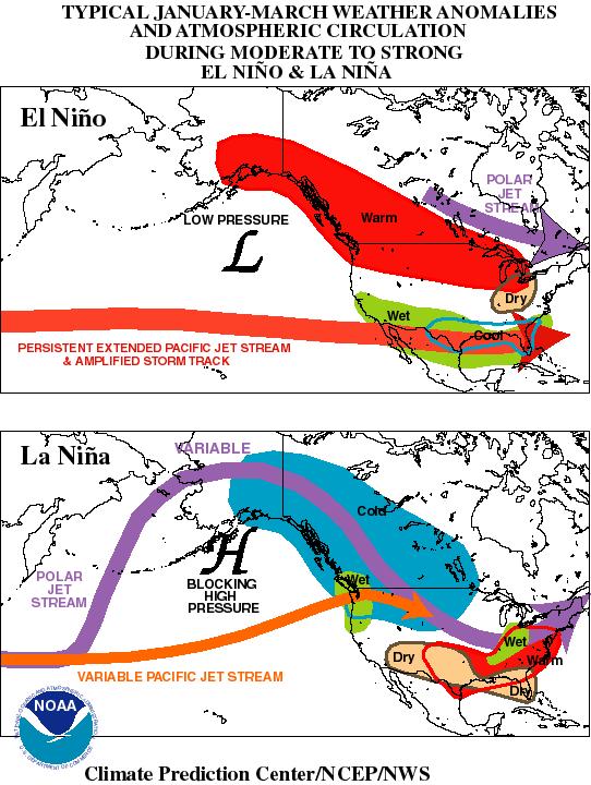
17 17
18 18 Questions on ENSO s Impact on Climate Variability 1. What is a teleconnection? A linkage between ENSO and climate variability in regions outside the Pacific Ocean. 2. What parts of the world have teleconnections been made between ENSO and climate conditions? Australia, North and South America, Southern Africa, India, Northern Africa, and South East Asia 3. Where are the strongest ENSO impacts found? Close to the equator 4. Two important points are discussed in the information regarding ENSO s affect on climate variability. Explain those two points in your own words. ENSO can increase or decrease amounts of precipitation, no one storm can be because of an ENSO. Others 5. Why is a change in the jet stream important in determining climate variability for the U.S.? A change modifies storm patterns 6. What happens to the Pacific jet stream during an El Niño phase during January to March? It is persistent and stays on a southern track. 7. What general affect does the change of the jet stream during an El Niño phase have on climate conditions in the southern U.S. during January to March? Southern U.S. tends to be wetter and cooler than normal 8. What general affect does the change of the jet stream during an El Niño phase have on climate conditions in the northern U.S. during the January to March.? Northern U.S. tends to be dryer and warmer than normal 9. What happens to the Pacific jet stream during a La Niña phase during January to March? Pushes north and is more variable
19 What general affect does the change of the jet stream during a La Niña phase have on climate conditions in the southern U.S. during January to March? Southern U.S. tends to be dryer and warmer than normal 11. What general affect does the change of the jet stream during a La Niña phase have on climate conditions in the northern U.S. during January to March? Northern U.S. tends to be wetter and cooler than normal 12. Understand the figure in the readings concerning the jet stream and climate variability across the U.S. Sketch the figure. El Nino Conditions La Nina Conditions After completing the questions above you are an expert on U.S. climate variability associated with ENSO. Your job is to explain this event to your new partners tomorrow. You should study your information and answers for homework and be ready to explain this process to your classmates tomorrow.
20 20 ENSO Jigsaw Worksheet - Pacific Ocean Aspects Under the normal conditions provide a definition of the physical aspect, whereas under El Nino and La Nina note the Pacific Ocean anomaly (difference from normal) for the phase. Be sure you understand the pictures and are able to sketch them. Hint: conditions are usually opposite between the two conditions. Anomaly from Normal Moves East Physical Aspect Definition / Importance Warm Pool of Water - importance Important in determining climate variability Anomaly from Normal Moves West Shallower in the west and deeper in the east Weakens Stays on a southern track Warm Pressure difference is small Less upwelling in the eastern Pacific leads to less plant and animal production in the eastern Pacific Thermocline The thermocline is the boundary between the colder deep water and warmer upper water layer. Trade Winds / Walker Circulation The Walker Circulation associated with the trade winds is the vertical and horizontal circulation of air associated with the trade winds. Jet Stream Jet streams are a relatively narrow band of strong wind in the upper levels of the atmosphere. Another Phase Name No Definition Southern Oscillation A see saw of air pressure near the equator between the eastern and western Pacific Ocean. Upwelling - Biological The thermocline is close to the surface is called upwelling. Where upwelling occurs there is more abundant life than areas of the ocean where upwelling does not occur. Deeper in the west and shallower in the east Strengthens Pushes north and are more variable Cold Large pressure difference More upwelling in eastern Pacific leads to more plant and animal production in the eastern Pacific
21 21 ENSO Jigsaw Worksheet U.S. Climate Variability Aspects 1. This page pertains to ENSO affects on climate, especially during January to March period. For the two different phases, mark (a circle would work) with a red pencil the areas of the U.S. that have warmer than normal temperatures. With a blue pencil, mark areas that have cooler than normal temperatures. In green, mark the areas that have higher than normal precipitation. Finally, in brown mark the areas that have lower than normal precipitation. Draw in the changes in the jet stream between the two phases. Be Neat! La Nina Cold Phase See readings for correct conditions and jet stream. El Nino Warm Phase 2. What is a teleconnection? A linkage between ENSO and climate variability in regions outside the Pacific Ocean. 3. Recall, Joe Soccer lives in Southern U.S. What is the typical anomaly associated with El Niño phase for precipitation and temperature in Texas? Rain wet Temperature cool 4. What is the typical anomaly associated with La Niña phase for precipitation and temperature in Texas? Rain dry Temperature warm 5. Do these anomalies always occur as you answered in questions 2 and 3 for El Niña and La Niña phases? Yes No 6. Discuss in your group how Joe might use the above information.
22 22 ENSO Jigsaw Worksheet Worldwide Climate Variability Aspects - Optional This page pertains to ENSO affects on climate. For the two different phases, mark (a circle would work) with a red pencil the areas that have warmer than normal temperatures. With a blue pencil, mark areas that have cooler than normal temperatures. In green, mark the areas that have higher than normal precipitation. Finally, in brown mark the areas that have lower than normal precipitation. On one of the maps, mark the location of the Niño 3.4 region. Be Neat! One may need to refer back to the Becoming an Expert on reading materials. See reading materials for correct answers. La Nina Cold Phase El Nino Warm Phase 1. Do these anomalies you colored put in the maps always occur as you answered for El Niña and La Niña phases? Yes No 2. Why do you think the anomalies are stronger in the equator region of the world than in the rest of the world? ENSO is located in the equator region and other phenomen located elsewhere also impact climate 3. Why do you think much of the research into ENSO has originated in Australia? Australia is one of the countries most impacted by ENSO
23 23 ENSO Crossword Puzzle - Optional Constructed using Crossword Weaver Across 2 Upper level winds that create storm tracks. 4 First scientist to rigorous study ENSO 5 precipitation and temperature over a period longer than two weeks 7 El Nino phase is sometimes know as this because of hotter than normal sea surface temperatures 8 Relationship between the ocean and atmosphere 11 The boundary between cold deep water and warmer upper layer of water in an body of water. 12 precipitation and temperature over a period of two weeks or less 14 Linkage between physical process in one region and climate variability in another region. 15 Walker is the vertical and horizontal movement of the trade winds, which form a circular pattern Down 1 Changes in climate between years is an example of this 3 changes from the normal or a base 6 Imaginary line around the middle of the world. 9 Oscillation refers to the seesaw pattern of air pressure between the western and eastern Pacific Ocean. 10 winds cause the sea level to be higher in the western Pacific Ocean 13 La Nina phase is sometimes known as this because of cooler than normal sea surface temperatures
24 24 ENSO Cross Word Puzzle Solution V J E T S T R E A M W A L K E R N R O C L I M A T E W A R M A Q O B C O U P L E D L I A S I L T T H E R M O C L I N E I R O U S T A R W E A T H E R Y D H C T E L E C O N N E C T I O N S R L C I R C U L A T I O N D
25 25 Other Effects of ENSO - Optional There is evidence of ENSO having an effect on the occurrence of forest fires, floods, and hurricanes, along with impacts on human health. But, what are these effects? As with ENSO, scientists are still learning about links between climate and other physical, biological, and human aspects. The following paragraphs provide brief explanations to how ENSO may affect these different aspects. Answer the following questions after reading the associated paragraphs. Forest Fires / Floods As you learned in the science module, ENSO impacts precipitation in various areas of the world. Changes in precipitation can lead to other changes in the environment. One such change is a change in the number of wildfires, both brush and forest fires. As you have learned previously, the different ENSO phases may cause some areas to be drier than normal. Decreased precipitation may lead to an increase in wildfires. For example, during some El Niño years, increased number and severity of forest fires have been reported in Indonesia (country northwest of Australia) and Australia. The most predominant year for forest fires in Indonesia was the El Nino of 1982 and The year also saw an increased number of forest fires. These years saw particularly strong El Niño phases. Similarly, increased precipitation associated with an ENSO phase in a particular area may cause an increase in flooding. But, not all years see an increase in fires or floods. 1. Why is there a greater risk of increased forest fires during an El Niño year in Australia? Australia has a higher chance of being dryer than normal 2. During what El Niño season were forest fires most predominant? What country has suffered the most recently from the effects of forest fires associated with the El Niño phase? Indonesia 4. Why do some areas see an increased probability of flooding during an El Niño year? Increased probability of higher precipitation levels
26 26 Hurricanes Hurricanes (also known as tropical cyclones or typhoons depending on the area of the world they occur) need warm ocean water to develop. Hurricanes occur during all ENSO phases. However, changes in the warm pool of water cause by the different ENSO phase have implications for location and development of hurricanes. In the western Pacific Ocean, El Niño phases decreases tropical cyclone activity. This is expected as the warm pool of water moves eastward. Activity in the central and eastern Pacific increases during El Niño phase. Hurricane activity in the Atlantic basin is affected by ENSO through changes in the Atlantic atmospheric circulation. El Niño phases contribute to a decreased numbers of Atlantic tropical storms and hurricanes. La Niña phases generally have opposite conditions, increased storms in the western Pacific and Atlantic Oceans and decreased storms in the central and eastern Pacific Ocean. Bove et al. ( give the average number of U.S. Atlantic hurricanes during El Niño years is 1.04, 1.61 during neutral years, and 2.23 during La Niña. 5. Why does a La Niña event increase the risk for of a hurricane in Australia? The warm pool has moved closer to Australia, and warm water is needed for hurricanes to forms. 6. How does an El Niño event affect the number of hurricanes affecting the U.S.? Hint: consider both Atlantic and Pacific Oceans. El Niño warms the eastern tropical Pacific Ocean, which aids in the growth of hurricanes in the eastern Pacific, but it is associated with a lower number of hurricanes in the Atlantic Ocean. 7. How does a La Niña event affect the number of hurricanes affecting the U.S.? Hint: consider both Atlantic and Pacific Oceans. La Niña warms the western tropical Pacific Ocean, which lowers the growth of hurricanes in the eastern Pacific, but it is associated with a higher number of hurricanes in the Atlantic Ocean. 8. During an El Niño phase 1.04 hurricanes always hit the U.S. True or false and why? False. This is the average number and not the number for any given year
27 27 Human Health The World Health Association notes a pattern between the different ENSO events and outbreak of diseases. However, generalizing the relationship between disease outbreaks and ENSO events is not easy. Local health delivery systems affect the incident of diseases. In addition, local ecological conditions, along with humidity, timing of precipitation, and temperature changes, affect the transmission of diseases. To illustrate the complex relationship between ENSO and diseases consider the case of malaria. Malaria is a mosquito borne disease. In countries that are normally relatively warm with low precipitation levels (such as countries in southern Africa), an ENSO phase that increases precipitation may be associated with increased cases of malaria. This occurs because increased precipitation causes increases in standing water necessary for mosquitoes to reproduce. More mosquitoes mean a higher chance for disease outbreak. Increased precipitation leads to increased cases of malaria. In countries that are normally warm and have high precipitation levels (such as Venezuela, Columbia, and Sri Lanka), an ENSO phase that decreases precipitation may lead to an outbreak of malaria. Decreased precipitation may turn normal flowing rivers into stagnant ponds. These stagnant ponds provide the breeding grounds for the mosquitoes which flowing rivers could not provide. Here, decreased precipitation leads to increased cases of malaria. In addition to malaria, researchers have found approximately 21 infectious diseases that may have a relationship with ENSO. Other diseases that may have a relationship with ENSO events include Dengue, Australian Encephalitis, Rift Valley Fever, and valley fever. Much more research is necessary to understand the relationship between health and ENSO events Malaria is transmitted by what insect? Mosquito 10. Besides ENSO what other factors are important in determining if a disease outbreak occurs. Local ecological conditions, local health system, local humidity, precipitation and temperatures. 11. Countries that normally have high precipitation levels may see an increase in malaria during ENSO phases that bring decreased precipitation. Why? Decreased precipitation may cause rivers to run slower, thus creating pools that mosquitoes can live in. Increased mosquitoes mean a better chance for a disease outbreak. 12. Countries that normally have low precipitation levels may see an increase in malaria during ENSO phases that bring increased precipitation. Why? Increased precipitation may stagnant pools of water to form that mosquitoes can live in. Increased mosquitoes mean a better chance for a disease outbreak.
28 Optional Question: ENSO impacts other physical and biological phenomenon in addition to the ones discussed here. Write a short paragraph on other potential ENSO impacts by conducting web-based research. Suggested topics, but not limited to, are fish production in the eastern Pacific, western U.S. snow pack, tornados in the U.S., droughts in Australia, and salmon production in the U.S. and British Columbia. For additional information see Forest Fires Human Health Hurricanes Tornados
29 29 Appendix A ENSO - Jigsaw Approach One method of teaching is the jigsaw approach. In this approach, students are placed into groups. Each group becomes the expert in a particular topic. After the groups have completed the expert materials, new groups are formed with an expert from each topic in the new group. An example for three topics is given in the figure below. Each box represents a group. In this setup, Claudia, Jose, and Fred become experts on trade winds, Seth, Cindy, and Lebron become experts on El Niño, and Ivan, Megan, and LeAnn are the La Niña experts. Each expert member then teaches their topic to students in the new group. For example, in new group 1, Claudia would teach trade winds, Seth El Niño, and Ivan La Niña. New groups 2 and 3 would be similar. In teaching the material in the new groups, each student in the class, finishes their ENSO Jigsaw Worksheet. Each expert material contains questions designed to provide the student the necessary knowledge to help fellow students complete the ENSO Jigsaw. The Jigsaw worksheet provides questions that summarize important concepts; as such the worksheet provides a review sheet for testing purposes. The jigsaw idea can be modified to fit your textbook. Trade Winds Claudia Jose Fred El Niño Seth Cindy Lebron La Niña Ivan Megan LeAnn New Group 1 Claudia Seth Ivan New Group 2 Jose Cindy Megan New Group 3 Fred Lebron LeAnn
Module 3, Investigation 1: Briefing 1 What are the effects of ENSO?
 Background The changing temperatures of the tropical Pacific Ocean affect climate variability all over Earth. Ocean warming and cooling dramatically affect human activities by changing weather patterns
The General Circulation and El Niño. Dr. Christopher M. Godfrey University of North Carolina at Asheville
 The General Circulation and El Niño Dr. Christopher M. Godfrey University of North Carolina at Asheville Global Circulation Model Air flow broken up into 3 cells Easterlies in the tropics (trade winds)
Currents. History. Pressure Cells 3/13/17. El Nino Southern Oscillation ENSO. Teleconnections and Oscillations. Neutral Conditions
 Teleconnections and Oscillations Teleconnection climate anomalies being related to each other over a large scale Oscillations: Macroscale movement of atmospheric systems that can influence weather, climate,
March 4 th, 2019 Sample Current Affairs
 March 4 th, 2019 Sample Current Affairs 1. A weak El Niño is developing in the equatorial Pacific Ocean, which is expected to continue for a few months at least. What is El Nino? What causes El Nino? What
- terminology. Further Reading: Chapter 07 of the text book. Outline. - characteristics of ENSO. -impacts
 (1 of 14) Further Reading: Chapter 07 of the text book Outline - terminology - characteristics of ENSO -impacts (2 of 14) Today: Introduction We want to look at another source of variability in the atmosphere
Ocean Inter-annual Variability: El Niño and La Niña. How does El Niño influence the oceans and climate patterns?
 Name: Date: Guiding Question: Ocean Inter-annual Variability: El Niño and La Niña How does El Niño influence the oceans and climate patterns? Introduction What is El Niño/La Niña? The El Niño/La Niña cycle
Lecture 13 El Niño/La Niña Ocean-Atmosphere Interaction. Idealized 3-Cell Model of Wind Patterns on a Rotating Earth. Previous Lecture!
 Lecture 13 El Niño/La Niña Ocean-Atmosphere Interaction Previous Lecture! Global Winds General Circulation of winds at the surface and aloft Polar Jet Stream Subtropical Jet Stream Monsoons 1 2 Radiation
El Niño Unit (2.5 pts)
") T. James Noyes, El Camino College El Niño Unit (Topic 9B) page 1 Name: Section: El Niño Unit (2.5 pts) El Niño is a warm ocean current that flows along the Equator and towards the west coast of South America
T. James Noyes, El Camino College El Niño Unit (Topic 9B) page 1 Name: Section: El Niño Unit (2.5 pts) El Niño is a warm ocean current that flows along the Equator and towards the west coast of South America
El Niño Lecture Notes
 El Niño Lecture Notes There is a huge link between the atmosphere & ocean. The oceans influence the atmosphere to affect climate, but the atmosphere also influences the ocean, which can also affect climate.
OCN 201 Lab Fall 2009 OCN 201. Lab 9 - El Niño
 OCN 201 Lab Fall 2009 OCN 201 Lab 9 - El Niño El Niño is probably one of the most widely publicized oceanic phenomena. If there s one single reason for that it s probably the fact that El Niño s presence
Current: large mass of continuously moving ocean water
 Ocean Currents Current: large mass of continuously moving ocean water Surface Currents--Wind Circulation These waters make up about 10% of all the water in the ocean. These waters are the upper 400 meters
Equatorial upwelling. Example of regional winds of small scale
 Example of regional winds of small scale Sea and land breezes Note on Fig. 8.11. Shows the case for southern hemisphere! Coastal upwelling and downwelling. Upwelling is caused by along shore winds, that
Lecture 29. The El-Niño Southern Oscillation (ENSO) La Niña = the girl; corresponds to the opposite climate situation
 La Niña = the girl; corresponds to the opposite climate situation") Lecture 29 The El-Niño Southern Oscillation (ENSO) El Niño is Spanish for Christ child, the name given by fishermen to a warm ocean current off the coast of Peru/Ecuador that in some years occurs near
Lecture 29 The El-Niño Southern Oscillation (ENSO) El Niño is Spanish for Christ child, the name given by fishermen to a warm ocean current off the coast of Peru/Ecuador that in some years occurs near
CHAPTER 7 Ocean Circulation
 1 2 3 4 5 6 7 8 9 10 11 12 13 14 CHAPTER 7 Ocean Circulation Words Ocean currents Moving seawater Surface ocean currents Transfer heat from warmer to cooler areas Similar to pattern of major wind belts
REMINDERS: UPCOMING REVIEW SESSIONS: - Thursday, Feb 27, 6:30-8:00pm in HSS 1330
 REMINDERS: Midterm 2: Friday, February 28 - lecture material covering chapters 6, 7, and 15 (since first midterm and through Wed lecture) - same Format as first midterm UPCOMING REVIEW SESSIONS: - Thursday,
3/22/11. General Circulation of the Atmosphere. General Circulation of the Atmosphere
 Chapter 10 General refers to the average air flow, actual winds will vary considerably. Average conditions help identify driving forces. The basic cause of the general circulation is unequal heating of
Your web browser (Safari 7) is out of date. For more security, comfort and the best experience on this site: Update your browser Ignore
 is out of date. For more security, comfort and the best experience on this site: Update your browser Ignore") Your web browser (Safari 7) is out of date. For more security, comfort and the best experience on this site: Update your browser Ignore L A NIÑA El Niño-Southern Oscillation (ENSO) For the complete encyclopedic
Your web browser (Safari 7) is out of date. For more security, comfort and the best experience on this site: Update your browser Ignore L A NIÑA El Niño-Southern Oscillation (ENSO) For the complete encyclopedic
Lecture 13 March 24, 2010, Wednesday. Atmospheric Pressure & Wind: Part 4
 Lecture 13 March 24, 2010, Wednesday Atmospheric Pressure & Wind: Part 4 Synoptic scale winds Mesoscale winds Microscale winds Air-sea interactions The largest synoptic scale wind. Monsoon: Arabic for
and the Link between Oceans, Atmosphere, and Weather
 Geography Worksheet Instructions Using a map, atlas, or any other materials your teacher suggests, label the following on the blank map provided. 1. Label East, West, North, and South. 2. Label the following
Chapter 10: Global Wind Systems
 Chapter 10: Global Wind Systems Three-cell model of atmospheric circulation Intertropical Convergence Zone (ITCZ) Typical surface wind patterns Upper-level pressure and winds Climatological sea-level pressure
Lecture 24. El Nino Southern Oscillation (ENSO) Part 1
 Part 1") Lecture 24 El Nino Southern Oscillation (ENSO) Part 1 The most dominant phenomenon in the interannual variation of the tropical oceanatmosphere system is the El Nino Southern Oscillation (ENSO) over the
Lecture 24 El Nino Southern Oscillation (ENSO) Part 1 The most dominant phenomenon in the interannual variation of the tropical oceanatmosphere system is the El Nino Southern Oscillation (ENSO) over the
Lecture 13. Global Wind Patterns and the Oceans EOM
 Lecture 13. Global Wind Patterns and the Oceans EOM Global Wind Patterns and the Oceans Drag from wind exerts a force called wind stress on the ocean surface in the direction of the wind. The currents
El Nino and Global Warming
 El Nino and Global Warming El Niño and Global Warming El Niño Climate Trade winds Barometric pressure Southern oscillation WHAT YOU WILL LEARN 1. You will identify the cause of El Niño events. 2. You will
& La Niña Southern Oscillation Index
 El Niño & La Niña Southern Oscillation Index Today: first of the natural changes Lectures 1) El Nino/La Nina: year- decadal changes in climate system 2) Next: Short term natural changes (centuries to millenia)
El Niño / Southern Oscillation (ENSO) and inter-annual climate variability
 and inter-annual climate variability") El Niño / Southern Oscillation (ENSO) and inter-annual climate variability seasonal cycle what is normal? monthly average conditions through a calendar year sea level pressure and surface winds surface
El Niño / Southern Oscillation (ENSO) and inter-annual climate variability seasonal cycle what is normal? monthly average conditions through a calendar year sea level pressure and surface winds surface
Ocean Currents that Redistribute Heat Globally
 Ocean Currents that Redistribute Heat Globally Ocean Circulation Ocean Currents Fig. CO7 OCEAN CURRENTS Surface ocean currents are similar to wind patterns: 1. Driven by Coriolis forces 2. Driven by winds
Introduction to Oceanography OCE 1001
 Introduction to Oceanography OCE 1001 Lecture Notes Chantale Bégin & Jessica Fry Version 2.1 10. Ocean Circulation (Trujillo, Chapter 7) Major ocean currents are stable and predictable; they have been
Name: OBJECTIVES: By the end of today s lesson, you will be able to
 7 th Grade Science Unit: Water s Cycles and Patterns Lesson: WCP 21 Name: Date: Monday, October 3, 2016 Homeroom: _ OBJECTIVES: By the end of today s lesson, you will be able to SWBAT Explain how currents
9/25/2014. Scales of Atmospheric Motion. Scales of Atmospheric Motion. Chapter 7: Circulation of the Atmosphere
 Chapter 7: Circulation of the Atmosphere The Atmosphere: An Introduction to Meteorology, 12 th Lutgens Tarbuck Lectures by: Heather Gallacher, Cleveland State University Scales of Atmospheric Motion Small-
Lesson: Ocean Circulation
 Lesson: Ocean Circulation By Keith Meldahl Corresponding to Chapter 9: Ocean Circulation As this figure shows, there is a connection between the prevailing easterly and westerly winds (discussed in Chapter
Trade winds How do they affect the tropical oceans? 10/9/13. Take away concepts and ideas. El Niño - Southern Oscillation (ENSO)
") El Niño - Southern Oscillation (ENSO) Ocean-atmosphere interactions Take away concepts and ideas What is El Niño, La Niña? Trade wind and Walker circulation. What is the Southern Oscillation? Tropical
El Niño - Southern Oscillation (ENSO) Ocean-atmosphere interactions Take away concepts and ideas What is El Niño, La Niña? Trade wind and Walker circulation. What is the Southern Oscillation? Tropical
Class Notes: Week 10. April 9 th,2019. Topics: Front and Mid-Latitude Wave Cyclones El Niño / La Niña Mid-term 2 review
 Class Notes: Week 10 April 9 th,2019 Topics: Front and Mid-Latitude Wave Cyclones El Niño / La Niña Mid-term 2 review Front- is a boundary between 2 different types of air masses Air masses with different
IX. Upper Ocean Circulation
 IX. Upper Ocean Circulation World Ocean Covers 71% of Earth s surface Contains 97% of surface water Arctic Ocean NH: 61% ocean, 39% land Pacific Ocean Atlantic Ocean Southern Ocean Indian Ocean SH: 81%
GEOS 201 Lab 13 Climate of Change InTeGrate Module Case studies 2.2 & 3.1
 Discerning Patterns: Does the North Atlantic oscillate? Climate variability, or short term climate change, can wreak havoc around the world. Dramatic year to year shifts in weather can have unanticipated
ORESU-G ORESU-G
 ORESU-G-97-008 ORESU-G 97-008 The Pacific Northwest: a Region of Transitions The unusual oceanic and atmospheric conditions of the Pacific Northwest create a remarkable and dynamic setting unlike any other
Chapter 9: Circulation of the Ocean
 Chapter 9: Circulation of the Ocean Tropical gardens on Britain s Scilly Isles. Only 48 kilometers (30 miles) off the coast of Cornwall at 50 N, these scenic islands lie in the path of the warm waters
El Niño and the Winter Weather Outlook
 El Niño and the 2015-2016 Winter Weather Outlook 2015 NASEO Annual Meeting http://www.ospo.noaa.gov/products/ocean/sst/anomaly/ NWS Boston February 10, 2015 Jimmy Taeger Meteorologist National Weather
Module 3, Investigation 1: Briefing 1 What are the effects of ENSO?
 Module 3, Investigation 1: Briefing 1 Background The changing temperatures of the tropical Pacific Ocean affect climate variability all over Earth. Ocean warming and cooling dramatically affect human activities
The Child. Mean Annual SST Cycle 11/19/12
 Introduction to Climatology GEOGRAPHY 300 El Niño-Southern Oscillation Tom Giambelluca University of Hawai i at Mānoa and Pacific Decadal Oscillation ENSO: El Niño-Southern Oscillation PDO: Pacific Decadal
McKnight's Physical Geography 11e
 Chapter 2 Lecture McKnight's Physical Geography 11e Lectures Chapter 5 Atmospheric Pressure and Wind Michael Commons Ohio Northern University Atmospheric Pressure and Wind The Nature of Atmospheric Pressure
ESCI 107 The Atmosphere Lesson 11 Global Circulation
 Reading: Meteorology Today, Chapter 10 THE GLOBAL CIRCULATION ESCI 107 The Atmosphere Lesson 11 Global Circulation Latitudinal heat imbalance The tropics receive more radiation than they emit. The polar
Variability in the tropical oceans - Monitoring and prediction of El Niño and La Niña -
 Variability in the tropical oceans - Monitoring and prediction of El Niño and La Niña - Jun ichi HIROSAWA Climate Prediction Division Japan Meteorological Agency SST anomaly in Nov. 1997 1 ( ) Outline
ESCI 485 Air/sea Interaction Lesson 9 Equatorial Adjustment and El Nino Dr. DeCaria
 ESCI 485 Air/sea Interaction Lesson 9 Equatorial Adjustment and El Nino Dr. DeCaria Reference: El Nino, La Nina, and the Southern Oscillation, Philander THE TWO-LAYER SHALLOW WATER MODEL The ocean can
Winds and Ocean Circulations
 Winds and Ocean Circulations AT 351 Lab 5 February 20, 2008 Sea Surface Temperatures 1 Temperature Structure of the Ocean Ocean Currents 2 What causes ocean circulation? The direction of most ocean currents
Recent Atmospheric and Oceanic Circulation Changes Affecting Winter Weather in North America. Dr. Art Douglas Professor Emeritus Creighton University
 Recent Atmospheric and Oceanic Circulation Changes Affecting Winter Weather in North America Dr. Art Douglas Professor Emeritus Creighton University Outline 1. The 2018 El Nino: A Northern Hemisphere induced
APPENDIX B NOAA DROUGHT ANALYSIS 29 OCTOBER 2007
 APPENDIX B NOAA DROUGHT ANALYSIS 29 OCTOBER 2007 ENSO Cycle: Recent Evolution, Current Status and Predictions Update prepared by Climate Prediction Center / NCEP October 29, 2007 Outline Overview Recent
Lecture Outlines PowerPoint. Chapter 18 Earth Science 11e Tarbuck/Lutgens
 Lecture Outlines PowerPoint Chapter 18 Earth Science 11e Tarbuck/Lutgens 2006 Pearson Prentice Hall This work is protected by United States copyright laws and is provided solely for the use of instructors
Pacific Climate Variability
 Pacific Climate Variability Pacific Islands Climate Education Partnership You may have heard the term climate variability. What does the term climate variability mean? What are the causes and effects of
Ocean Currents Unit (4 pts)
") Name: Section: Ocean Currents Unit (Topic 9A-1) page 1 Ocean Currents Unit (4 pts) Ocean Currents An ocean current is like a river in the ocean: water is flowing traveling from place to place. Historically,
Name: Section: Ocean Currents Unit (Topic 9A-1) page 1 Ocean Currents Unit (4 pts) Ocean Currents An ocean current is like a river in the ocean: water is flowing traveling from place to place. Historically,
Global Circulations. GEOG/ENST 2331 Lecture 15 Ahrens: Chapter 10
 Global Circulations GEOG/ENST 2331 Lecture 15 Ahrens: Chapter 10 Last lecture Microscale (turbulence) Mesoscale (land/sea breeze) Synoptic scale (monsoon) Global scale (3 cell circulation) Three Cell Model
Overview. Learning Goals. Prior Knowledge. UWHS Climate Science. Grade Level Time Required Part I 30 minutes Part II 2+ hours Part III
 Draft 2/2014 UWHS Climate Science Unit 3: Natural Variability Chapter 5 in Kump et al Nancy Flowers Overview This module provides a hands-on learning experience where students will analyze sea surface
ENSO Cycle: Recent Evolution, Current Status and Predictions. Update prepared by Climate Prediction Center / NCEP 8 March 2010
 ENSO Cycle: Recent Evolution, Current Status and Predictions Update prepared by Climate Prediction Center / NCEP 8 March 2010 Outline Overview Recent Evolution and Current Conditions Oceanic Niño Index
(20 points) 1. ENSO is a coupled climate phenomenon in the tropical Pacific that has both regional and global impacts.
 1. ENSO is a coupled climate phenomenon in the tropical Pacific that has both regional and global impacts.") SIO 210 Problem Set 4 Answer key December 1, 2014 Due Dec. 12, 2014 (20 points) 1. ENSO is a coupled climate phenomenon in the tropical Pacific that has both regional and global impacts. (2 points) a)
SIO 210 Problem Set 4 Answer key December 1, 2014 Due Dec. 12, 2014 (20 points) 1. ENSO is a coupled climate phenomenon in the tropical Pacific that has both regional and global impacts. (2 points) a)
Midterm Exam III November 25, 2:10
 Midterm Exam III November 25, 2:10 25, 2:10 3:25 pm, HW714 Chapters 7 (7.12 7.17), 8 and 9 (through section 9.15, included) 60 multiple choice questions this exam constitutes 22% (only) of your total (overall)
Section 1. Global Wind Patterns and Weather. What Do You See? Think About It. Investigate. Learning Outcomes
 Chapter 5 Winds, Oceans, Weather, and Climate Section 1 Global Wind Patterns and Weather What Do You See? Learning Outcomes In this section, you will Determine the effects of Earth s rotation and the uneven
Atmospheric Circulation. Recall Vertical Circulation
 Today s topics: Atmospheric circulation: generation of wind patterns on a rotating Earth Seasonal patterns of climate: Monsoons and El Niño Tropical Cyclones: Hurricanes and typhoons Atmospheric Circulation
Weather drivers in South Australia
 August 2008 Key facts Weather drivers in South Australia Major weather drivers in South Australia are: El Niño - Southern Oscillation frontal systems cut-off lows blocking highs Indian Ocean Dipole cloudbands
Section 6. The Surface Circulation of the Ocean. What Do You See? Think About It. Investigate. Learning Outcomes
 Chapter 5 Winds, Oceans, Weather, and Climate Section 6 The Surface Circulation of the Ocean What Do You See? Learning Outcomes In this section, you will Understand the general paths of surface ocean currents.
Atmosphere & Weather. Earth Science
 Atmosphere & Weather Earth Science Energy Transfer in the Atmosphere Earth s energy is provided by the SUN! Energy is important to us because it 1. Drives winds and ocean currents. 2. Allows plants to
Friday, February 8 th. Winds/Coriolis Worksheet: Due Today Lab Worksheet: Finish Questions
 Ocean Currents Friday, February 8 th Winds/Coriolis Worksheet: Due Today Lab Worksheet: Finish Questions Non-rotating Earth Convection cell model Add rotation and add landmasses unequal heating and cooling
2 Air Masses and Fronts
 CHAPTER 16 2 Air Masses and Fronts SECTION Understanding Weather BEFORE YOU READ After you read this section, you should be able to answer these questions: How is an air mass different from a front? How
Wednesday, September 27, 2017 Test Monday, about half-way through grading. No D2L Assessment this week, watch for one next week
 Wednesday, September 27, 2017 Test Monday, about half-way through grading No D2L Assessment this week, watch for one next week Homework 3 Climate Variability (due Monday, October 9) Quick comment on Coriolis
ENSO Wrap-Up. Current state of the Pacific and Indian Ocean
 18-11-2014 ENSO Wrap-Up Current state of the Pacific and Indian Ocean Tropical Pacific Ocean moves closer to El Niño The Pacific Ocean has shown some renewed signs of El Niño development in recent weeks.
Weather drivers in Victoria
 August 2008 Weather drivers in Victoria Key facts Major weather drivers in Victoria are: El Niño - Southern Oscillation frontal systems cut-off lows blocking highs Southern Annular Mode cloudbands Figure
Global Impacts of El Niño on Agriculture
 Global Impacts of El Niño on Agriculture Presented to the University of Arkansas Division of Agriculture s Food and Agribusiness Series Webinar Series Presented by: Mark Brusberg and Brian Morris USDA
3 Global Winds and Local Winds
 CHAPTER 15 3 Global Winds and Local Winds SECTION The Atmosphere BEFORE YOU READ After you read this section, you should be able to answer these questions: What causes wind? What is the Coriolis effect?
Welcome to GCSE Geography. Where will it take us today?
 Welcome to GCSE Geography Where will it take us today? Topic 1.1: global hazards 1.1a: How can weather be hazardous? iii) El Nino, La Nina and their impact on drought 12/10/2018 Think back.. This a affects
Wind in the Atmosphere
 Lesson 2 Wind in the Atmosphere ESSENTIAL QUESTION What is wind? By the end of this lesson, you should be able to explain how energy provided by the sun causes atmospheric movement, called wind. p 6.ESS2.2,
Grade 8 Science. Unit 1: Water Systems on Earth Chapter 3
 Grade 8 Science Unit 1: Water Systems on Earth Chapter 3 Heat Capacity A measure of how long it takes a material to heat up or cool down. Water has a high heat capacity... It takes a long time to heat
Chapter. Air Pressure and Wind
 Chapter Air Pressure and Wind 19.1 Understanding Air Pressure Air Pressure Defined Air pressure is the pressure exerted by the weight of air. 19.1 Understanding Air Pressure Air Pressure Defined Air pressure
Canada s vast size creates a diverse range of weather conditions and climatic conditions. Warming trend for last 10 years Wet Spring Dry five summers
 Chapter 4 Weather and Climate Canada s vast size creates a diverse range of weather conditions and climatic conditions. Weather examples: Rainy today Snow tomorrow Fog on Wednesday 23 degree C today High
Atmospheric Circulation. Recall Vertical Circulation
 Today s topics: Atmospheric circulation: generation of wind patterns on a rotating Earth Seasonal patterns of climate: Monsoons and Sea Breezes Tropical Cyclones: Hurricanes and typhoons Atmospheric Circulation
2015 Evelyn Browning Garriss. El Niño, the Twisted Atlantic and the Effect on Global Agriculture
 2015 Evelyn Browning Garriss El Niño, the Twisted Atlantic and the Effect on Global Agriculture Conclusions Climate change is not linear. It ebbs and flows. Recent polar volcano eruptions created a cool
Agronomy 406 World Climates
 Agronomy 406 World Climates January 30, 2018 Monsoons. Ocean properties and circulation. Review for today: Online textbook: 1.3.1 (Sea water) Composition and properties. For Thursday: Rahmstorf, S.: The
Leeuwin Current - Reading
 Leeuwin Current At 5,500 kilometres, the Leeuwin is our longest ocean current! One of Australia s most influential natural features, the Leeuwin Current, has been confirmed as the longest continuous coastal
Quiz name: Oceanography - Land and Sea Interaction - Quiz #2
 Name: Quiz name: Oceanography - Land and Sea Interaction - Quiz #2 ate: 1. What is the direction of spin for gyres in the northern hemisphere? clockwise counter clockwise northern oscillation southern
The Setting - Climatology of the Hawaiian Archipelago. Link to Video of Maui Waves
 The Setting - Climatology of the Hawaiian Archipelago Link to Video of Maui Waves What caused this week s weather? What caused this weekend s weather? Today s Objective: Provide overview and description
Sailing the Seas: Wind Driven Ocean Circulation Ocean Gyres
 Sailing the Seas: Wind Driven Ocean Circulation Ocean Gyres Ocean Currents What Happens at the Coast? Readings: Ch 9: 9.2-9.6, 9.8-9.13 Graphic: America's Cup sailboat race off Newport, Rhode Island. J.
Summary of Lecture 10, 04 March 2008 Introduce the Hadley circulation and examine global weather patterns. Discuss jet stream dynamics jet streams
 Summary of Lecture 10, 04 March 2008 Introduce the Hadley circulation and examine global weather patterns. Discuss jet stream dynamics jet streams arise because the Coriolis force prevents Hadley-type
Air Pressure and Wind
 Air Pressure and Wind 19.1 Understanding Air Pressure Air Pressure Defined Air pressure is the pressure exerted by the weight of air. Air pressure is exerted in all directions down, up, and sideways. The
ATOMOSPERIC PRESSURE, WIND & CIRCULATION
 ATOMOSPERIC PRESSURE, WIND & CIRCULATION A. INTRODUCTION Important because: pressure patterns drive wind patterns which in turn drive oceanic circulation patterns o atmospheric & oceanic circulation: major
General Introduction to Climate Drivers and BoM Climate Services Products
 General Introduction to Climate Drivers and BoM Climate Services Products Climate Information Services Australian Bureau of Meteorology Yuriy Kuleshov El Niño Southern Oscillation (ENSO) El Niño Southern
T. James Noyes, El Camino College Winds Unit (Topic 8A-1) page 1
 page 1") T. James Noyes, El Camino College Winds Unit (Topic 8A-1) page 1 Name: Section: Winds Unit (3 pts) The Ocean and the Atmosphere We need to learn about the atmosphere, because the ocean and atmosphere are
T. James Noyes, El Camino College Winds Unit (Topic 8A-1) page 1 Name: Section: Winds Unit (3 pts) The Ocean and the Atmosphere We need to learn about the atmosphere, because the ocean and atmosphere are
Canada s Natural Systems. Canadian Geography 1202
 Canada s Natural Systems Canadian Geography 1202 Canada s Natural Systems Natural System: A system found in nature Here are the four natural systems that we will explore in the next few weeks 1. Canada
THE ATMOSPHERE. WEATHER and CLIMATE. The Atmosphere 10/12/2018 R E M I N D E R S. PART II: People and their. weather. climate?
 R E M I N D E R S Two required essays are due by Oct. 30, 2018. (A third may be used for extra credit in place of a Think Geographically essay.) ESSAY TOPICS (choose any two): Contributions of a noted
Meteorology I Pre test for the Second Examination
 Meteorology I Pre test for the Second Examination MULTIPLE CHOICE 1. A primary reason why land areas warm up more rapidly than water areas is that a) on land, all solar energy is absorbed in a shallow
Appendix E Mangaone Stream at Ratanui Hydrological Gauging Station Influence of IPO on Stream Flow
 NZ Transport Agency Peka Peka to North Ōtaki Expressway Hydraulic Investigations for Expressway Crossing of Mangaone Stream and Floodplain Appendix E Mangaone Stream at Ratanui Hydrological Gauging Station
Applied Earth Science Climate Exam Practice Questions Page 1
 Name: 1. Which combination of climate factors generally results in the coldest temperatures? A) low elevation and low latitude B) low elevation and high latitude C) high elevation and low latitude D) high
GLOBE Data Explorations
 Rainfall in the GLOBE Africa Region: A GLOBE Data Exploration Purpose Through explorations of GLOBE rain depth data from Africa, students learn about seasonal patterns in locations affected by monsoons.
Air Masses and Fronts
 Air Masses and Fronts A huge body of air that has similar temperature, humidity, and air pressure at any given height is called an air mass. A single air mass may spread over millions of square kilometers
Climate briefing. Wellington region, February Alex Pezza and Mike Thompson Environmental Science Department
 Climate briefing Wellington region, February 2016 Alex Pezza and Mike Thompson Environmental Science Department For more information, contact the Greater Wellington Regional Council: Wellington PO Box
Earth s Atmosphere. Air Currents
 CHAPTER 12 Earth s Atmosphere LESSON 3 Air Currents What do you think? Read the two statements below and decide whether you agree or disagree with them. Place an A in the Before column if you agree with
Global Winds and Local Winds
 Global Winds and Local Winds National Science Education Standards ES 1j What is the Coriolis effect? What are the major global wind systems on Earth? What Causes Wind? Wind is moving air caused by differences
Review for the second quarter. Mechanisms for cloud formation
 Review for the second quarter Mechanisms for cloud formation 1 Rising air expands and cools; Sinking air compresses and warms. (18) (24) Dry adiabatic lapse rate (10 o C/km): the rate of temperature decrease
Chapter 22, Section 1 - Ocean Currents. Section Objectives
 Chapter 22, Section 1 - Ocean Currents Section Objectives Intro Surface Currents Factors Affecting Ocean Currents Global Wind Belts (you should draw and label a diagram of the global wind belts) The Coriolis
Ocean Circulation, Food Webs and Climate What does the wind have to do with feeding fish (and feeding us)?
?") Ocean Circulation, Food Webs and Climate What does the wind have to do with feeding fish (and feeding us)? El Niño: Tropical Oceans and Global Climate Reading: 9.10-9.13, 9.15 Graphic: Upwelling off Cape
Ocean Circulation, Food Webs and Climate What does the wind have to do with feeding fish (and feeding us)? El Niño: Tropical Oceans and Global Climate Reading: 9.10-9.13, 9.15 Graphic: Upwelling off Cape
3 Global Winds and Local Winds
 CHAPTER 6 3 Global Winds and Local Winds SECTION The Atmosphere BEFORE YOU READ After you read this section, you should be able to answer these questions: What causes wind? What is the Coriolis effect?
Topic 3. : Atmospheric Pressure and Wind System
 Topic 3. : Atmospheric Pressure and Wind System Compiled by M S Jadhav, Assistant Professor in Geography, Ahmadnagar College, Ahmednagar. Note: This document is only for SYBA student as class notes and
El Nino/La Nina. What is El Nino? From NOAA website
 El Nino/La Nina What is El Nino? From NOAA website El Nino was originally recognized by fishermen off the coast of South America as the appearance of unusually warm water in the Pacific Ocean, occurring
3. Climatic Variability. El Niño and the Southern Oscillation Madden-Julian Oscillation Equatorial waves
 Georges (1998) 3. Climatic Variability El Niño and the Southern Oscillation Madden-Julian Oscillation Equatorial waves ENVIRONMENTAL CONDITIONS FOR TROPICAL CYCLONES TO FORM AND GROW Ocean surface waters