Anchoring Is Important
|
|
|
- Gwenda Malone
- 5 years ago
- Views:
Transcription

1 BCC Sailing Classes - Third Theory Anchoring Anchoring Is Important 1
2 The Anchor is your last resort. Anchoring Keep off a lee shore. Needs to be shaped (type of anchor) to bury in the type of bottom for the area. Needs to be light enough to be lifted aboard. When on vacation, either chartering or on your own boat, you will anchor for the evening, if the boat starts to drag, the chances are great, you will be asleep. Many charter companies want you to use mooring buoys, not anchors. Most cruising boats carry multiple anchors. Usually different types and weights. Chartering and Anchoring You will not know there is a problem until you are on the lee shore. If you discover you are dragging anchor, increase scope. Use the dive bag trick. 2
. General Types of Anchors Cement Blocks (or any kind of weight). Burying anchors (A, B, C, D). Shanks and flukes bury. Hooking anchors (B, E).")
3 4 Prerequisites to a Good Anchorage 1. Protection from current weather, forecasted weather and traffic. 2. Room to swing (360 degrees). 3. Proper depth of water. 4. Type of bottom (sand, mud not weeds). General Types of Anchors Cement Blocks (or any kind of weight). Burying anchors (A, B, C, D). Shanks and flukes bury. Hooking anchors (B, E). Bite more quickly and may require less scope. 3
4 Using A Weight As An Anchor (1) Using A Weight As An Anchor (2) 4
5 The Proper Anchoring Diagram Match The Type Of Anchor To The Type Of Bottom You Will Be Anchoring In 5
6 Burying Anchors Danforth Style Anchor Anchors With Wide Flukes Will Not Go Through Weeds Probably the most common anchor style. Holds extremely well especially in mud or sand. Inexpensive. Many copies available. Most copies not worth the $. Does not work in weeds, grass or soft mud! 6
7 The Plow Bury the shank so will not foul anchor rode. Point will punch through hard ground. Very good anchor with a pivoting shank. The Bruce No pivot on the shank. Can easily get stuck around something on the bottom. Notice the permanent attachment for the trip line. 7


8 A Trip Line Used Any Time You Suspect A Problem Raising The Anchor Mushroom Style Used for permanent moorings. Works its way deeper and deeper. 8

9 Hooking Style Anchors Fisherman Style Northhill Style All Hooking anchors are designed to punch through any bottom type. One fluke will always sit proud on the bottom. If boat rotates 360 degrees, the anchor rode could snag on the exposed fluke. 9

10 Navy Style Designed to drag. Other Anchors Not recommended. 10
11 What Is Scope The single most important part of anchoring. Total length of anchor rode as a ratio to the depth of water. 7:1 in an area where the water depth is 10 ft. would mean you would need 70 ft of line. Always calculate for what the predicted high tide will be. Remember to add the amount of freeboard of the vessel. General guidelines are; Lunch hook - 3:1 Overnight - 5:1 to 7:1 (7:1 is better if you have the swing room) The downfall, the longer the scope, the greater the swing room requirement. Scope & Swing Room Wind Direction Boat A can not anchor in this spot. If the wind was to shift 180, the boat would be aground. A B C 11
12 Scope & Swing Room Boat A is now positioned to allow it to swing a full 360 and not run aground. But what about the other boats?? Wind Direction B A C Scope & Swing Room All the boats will swing together, so there should be no issues with the spacing of the boats. If the boats are vastly different in configuration, there could be issues that you will need to plan for. Wind Direction B A C 12
13 The Proper Anchoring Diagram The first boat at an anchorage has the rights. The Effect of Chain Keeps the stock of the anchor pulling flat along the bottom. Acts as a shock absorber: When a wave hits the boat, the boat surges back, which lifts the chain off the ocean floor. After the wave passes, the chain settles back down to the ocean floor, returning the boat to it s original position. Prevents chafe of anchor rode. Decreases scope. 13

14 Picking Up A Mooring Ball 1. Approach the mooring from downwind. 2. Have someone ready with something to snag the pennant with. 3. Practice hand signals ahead of time, so that the person on the bow can guide the boat to the mooring. 4. Attach to the bow cleat. 5. If you miss it the first time, go around and try a second time. BCC Sailing Classes - Third Theory Navigation 14

15 BCC Sailing Classes - Third Theory Chart Symbols We Are Going To Use Chart

 &")


16 Items Required For Basic (Coastal) Navigation A Compass. Navigation charts. Timekeeping Device. Parallel Rules (or Rolling Ruler) & Dividers. Compass Parallel Rules Rolling Rules Dividers Two Most Important Items To Notice On A Chart Soundings What are the depths measured in. Projection either Mercator of Polyconic. 16
 Projection: Mercator Polyconic. Depths All depths are relative to Datum.")

17 Two Most Important Items To Notice On A Chart Soundings: Feet Fathoms (1 fathom = 6 feet) Meters (all the rest of the world) Projection: Mercator Polyconic. Depths All depths are relative to Datum. Average low water (averaged daily in the US), over 18 + years. A solar year is 18 + earth years long. Areas that share a common depth are connected with a line. Areas to one side of the line are shallower, the other deeper. 17

 Polyconic Projection Used mostly for air navigation, since the scale is usually very large, the flat")
18 Two Types of Projection Mercator Projection Think of the earth being placed inside a tube of paper, a light from inside the globe shines an image of the earth on to the sheet of paper. For distance measurements, one minute of latitude = 1 nautical mile (6076 ft) ( multiplying factor 1.15 statute miles). Two Types of Projection (2) Polyconic Projection Used mostly for air navigation, since the scale is usually very large, the flat paper looks like the earth. For distance measurements -use the scale provided. 18
.")
19 Every country has a Chart #1. The index and position of each symbol is the same for every country. To download a current (free) copy of the U.S. Chart No.1. /mcd/chartno1.htm Chart # 1 Rocks Rocks less than 6 ft. below datum. Rocks awash at Datum Rocks that cover and uncover with tidal flow. Rocks above high water all the time (Islands)..... ( 6) 28 19
20 Nature of the Seabed Rocky bottom Sandy bottom Clay bottom R S Cl Kelp Shipwrecks Wreck with some structure showing. Wreck depth unknown. Direction of Flood Tidal Current. Direction of Ebb Tidal Current. 20

21 On the Martha s Vineyard To Block Island Chart go to the following Area 21

22 Traffic Separation Scheme Used By Large Ships All ships stay to the right. BCC Sailing Classes - Third Theory Navigation Light Patterns 22
23 Lit Beacons Visible day or night. To be able to distinguish between the lights, each light has a unique characteristic. The default time of a flash is every 4 seconds. The default color is white. Light Patterns Whenever you are given a time for a light characteristic, it is always the period of the characteristic. The length of time from the start of one repetitive sequence to the start of the next repetitive sequence. Example: An 4s. equal interval light (on for the same length of time as off) will be on for seconds and off for seconds. 23

24 To See An Example Of Light Patterns Go to: Lessons Navigation Light Patterns Location Dropdown Pattern Dropdown Light Patterns Flashing Symbol - Fl The light flashes once in a given period of time. Fl G 4s Flashing Green, once every 4 seconds
25 Light Patterns Group Flashing Symbol Fl (2) The light flashes multiple times (at the start) in a given period of time. Fl (2) R 10s Flashing Red, twice every 10 seconds Quick Flashing Light Patterns Quick Flashing Symbol - Q Flashing, once every second
26 Light Patterns Isopheric Symbol - Iso Isopheric the old symbol was Equal Interval. Light is on for the same time that it is off. Iso 4s Light Patterns Occulting Symbol - Oc Occulting. Light is on for longer than it is off. The opposite of flashing Oc 5s
27 Light Patterns Morse (A) Symbol Mo (A) Always located on a mid-channel buoy. Light is always white. Typically a 6 second period Light Patterns Composite Lights Symbol Fl R (2+1) Always located in a situation where the channel splits between a primary & secondary channel. Light is always either red or green. Typically a 6 second period
28 Light Patterns Fixed Symbol F The light remains on all the time. Typically used with another light as a combination of lights. Get Your Cadence Count to 10 seconds without looking at your watch. How accurate were you? You need to be able to count the seconds, watch the light and drive the boat all at the same time. 28
29 BCC Sailing Classes - Third Theory Navigation Lights How Used The Americas We Are Going To Use Chart
30 On the Martha s Vineyard To Block Island Chart Go to the following Area On the Martha s Vineyard To Block Island Chart - Note the Following G 1 Wrecks Fl R 2.5s 30ft 6M 8 F G 27 ft. 11M 3 30


31 Light Patterns Fl G 5 sec 67ft 20M Horn Flashing Green, once every 5 seconds, 67 feet above high water, visible for 20 nominal miles, with a horn as a fog signal
 Can be anything from a floating (colored) stake in the water with no symbols to a post with a red triangle (starboard side) or a green square (Port side).")
32 Navigation Buoy Standards (U.S.) Red Right Returning When returning to harbor, keep the red lights to the right. Red buoys are assigned even numbers, green odd. Day Beacons (Unlit Buoys) Can be anything from a floating (colored) stake in the water with no symbols to a post with a red triangle (starboard side) or a green square (Port side). Green Port Day Marker Red Starboard Day Marker 32
 white light. Will have letters on the buoy, not numbers.")

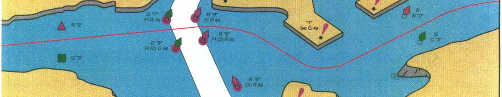
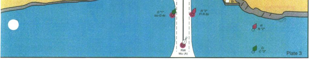
33 Mid Channel Buoys (Safewater) Historically known as a Mid Channel buoy, is now called a Safewater buoy. Has vertical stripes Will flash a Mo (A) white light. Will have letters on the buoy, not numbers. In a traffic separation scheme, the mid channel buoy will separate the inbound and outbound traffic. Bifurcation Buoys Separates the channel into a primary and secondary channel. Is colored both red and green horizontal stripes. The primary channel is typically deeper, heavier travelled and with fewer navigational hazards. 33
34 Standards for the Lateral System Standard Lateral buoys - Solid colors are on each side of the channel. Starboard buoys are red, cone shaped (pointed) and evenly numbered. Port hand buoys are green, square and odd numbered. Mid Channel (Safewater) buoys have vertical stripes. Always have letters as identifying markers. Flash a Mo (A). Bifurcation buoys (two colored horizontal coloring), indicate a buoy. Top color indicates the primary channel (deeper, wider, more travelled). Use second color for the secondary channel. Will always have a composite light characteristic. On the Martha s Vineyard To Block Island Chart Go to the following Area 34
35 Light Patterns Fl G 6s 35ft 5M 3 Horn Flashing green, once every 6 seconds, 35 feet above high water, visible for 5 nominal miles, has the number 3 painted on it, with a fog horn Fl R 4s 40ft 5M 2 Flashing red, once every 4 seconds, 40 feet above high water, visible for 5 nominal miles, has the number 2 painted on it, with a fog horn. Light Patterns

36 On the Martha s Vineyard To Block Island Chart Go to the following Area 36

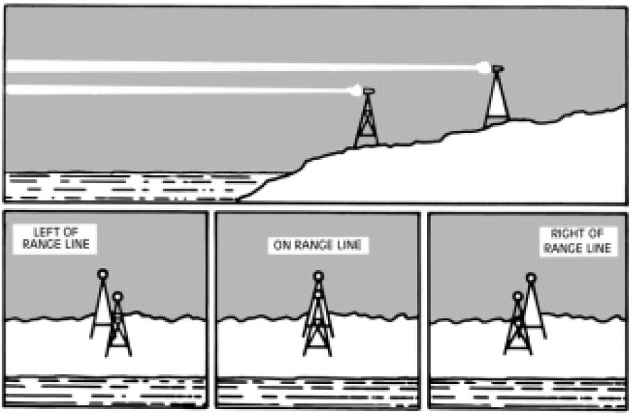
37 Range Lights 37


38 Columbia River Chart Note the following: 1. Mid Channel Buoy 2. Entrance range 3. Bifurcation Buoy 4. Preferred Channel 5. Secondary Channel 38

39 39
40 BCC Sailing Classes - Third Theory Tides & Tidal Currents Tides & Tidal Currents Tides are the vertical rise and fall of the water. Tidal Currents are the horizontal flow that is caused by the vertical rise and fall. 40


41 Tides & Currents Tide Tables 41

42 Why Tidal Currents There are three factors that govern the amount of tidal current. Height of tide. Time between high and low tides Ratio of size of channel to area behind it. Current Tables 42
Chart Features Maritime maps and Admiralty charts have these features:
 Introduction to Charts A chart or map of the area is an important safety item to carry on board. It allows the Master to obtain knowledge of the area to be travelled, and indicates the navigable channels
IALA Buoyage System and Visual Aids to Navigation. by Aleksandr D. Pipchenko
 IALA Buoyage System and Visual Aids to Navigation by Aleksandr D. Pipchenko IALA buoyage regions chart Which types of marks are provided by the system? Six types of marks provided by the system: Lateral
CHAPTER 1 ANCHORING Forces Affecting an Anchored Vessel
 CHAPTER 1 ANCHORING 1.1. Forces Affecting an Anchored Vessel According to the Ecuadorian Navigator Officer Guidelines, anchorage site selection involves two stages, first to take into account all forces
Aids to navigation can include buoys, day beacons, range markers, and lighthouses.
 This boating safety course manual has been approved by Transport Canada strictly on the basis that it meets the minimum requirements of basic boating safety knowledge set out in Transport Canada s Boating
A buoy, for example is an aid to navigation. Aids to navigation include many types of buoys as well as day beacons, range markers, and lighthouses.
 This online study guide has been approved by Transport Canada strictly on the basis that it meets the requirements of the Standard for Pleasure Craft Operator Testing over the Internet (TP 15080E) and
A N C H O R I N G. Don't handle lines if you have been drinking or are smoking ( if you re doing drugs, you ve already been thrown off the boat )
") Our Professional Instructors Average More than 20 Years Experience On The Water Only American Sailing Assn. & International Yachtmaster Certification Facility in U.S. A N C H O R I N G Est. 1978, 2 5 th
Our Professional Instructors Average More than 20 Years Experience On The Water Only American Sailing Assn. & International Yachtmaster Certification Facility in U.S. A N C H O R I N G Est. 1978, 2 5 th
Stars and Compass Trophy and Novice Paper 2014!
 Stars and Compass Trophy and Novice Paper 2014 The Stars and Compass Trophy was established to promote the use and development of traditional navigation skills. This year, in a bid to encourage novice
An Introduction To Marine Charts
 An Introduction To Marine Charts //captnmike.com Revised August 29, 2011 An Illustrated introduction to U. S. Aids to Navigation in the Shilshole Bay area of Puget Sound, Washington. The chart symbols
National Maritime Center
 National Maritime Center Providing Credentials to Mariners Able Seaman Unlimited, Limited, Special, Special OSV, Sail, Fishing Industry (Sample Examination) Page 1 of 17 Choose the best answer to the following
Chapter 8. Port hand buoy. Starboard hand buoy. Canadian Aids to Navigation System (CANS) 8.1 Introduction. 8.2 Lateral Buoys
 8.1 Introduction. 8.2 Lateral Buoys") Chapter 8 Canadian Aids to Navigation System (CANS) 8.1 Introduction Various buoys, beacons and signs are known as "Aids to Navigation" or "Navigation Aids". They are devices or systems external to the
Chapter 8 Canadian Aids to Navigation System (CANS) 8.1 Introduction Various buoys, beacons and signs are known as "Aids to Navigation" or "Navigation Aids". They are devices or systems external to the
 Page 1 of 6 Nav-Aid Basics Unlike the roads and highways that we drive on, the waterways we go boating on do not have road signs that tell us our location, the route or distance to a destination, or of
Plot the Path into the Harbor
 Plot the Path into the Harbor By Mary Anne Otten, Rudyard Area Schools and Joan Chadde, Michigan Technological University Subject/Grade: Grade 3 6, Math, Social Studies, Science Duration: 35 minutes Lesson
2005 ABC. Chapter 3 Part 2. Navigating with ATON's. Revision to D-13 Local Notes. Instructor Notes for Mike Brough. Mike Brough
 2005 ABC Chapter 3 Part 2 Navigating with ATON's Revision to D-13 Local Notes Instructor Notes for Mike Brough Mike Brough June 24 2008 June 24 2008 Slide 1 June 24 2008 New graphics Navigating on Water
Nautical Chart Challenge
 Discover Your World With NOAA Nautical Chart Challenge For as long as anyone in his family could remember, Francis Beaufort wanted to make scientific observations from the deck of a ship. In 1789 at the
1995 Puget Sound Anchor Test Report
 1995 Puget Sound Anchor Test Report In June 1995, we participated in a anchor test conducted by the Sailing Foundation of Seattle, WA. We tested eight different types of anchors in five sites around Puget
Plot the Path. Mary Anne Otten. lesson three
 Plot the Path Mary Anne Otten lesson three Subject/Grade: Grade 2, Math, Social Studies, Science Duration: one class period Materials needed: Per class: Day the Great Lakes Drained Away by Charles Ferguson
CHAPTER 8 BUOYAGE 8.1 GENERAL
 145 CHAPTER 8 BUOYAGE 8.1 GENERAL The term `buoyage encompasses all floating structure such as buoys or beacons which are used to orientate mariners and to mark the edges of navigable channels and fairways.
National Maritime Center
 National Maritime Center Providing Credentials to Mariners (Sample Examination) Page 1 of 13 Choose the best answer to the following Multiple Choice Questions. 1. What is the approximate geographic range
SECTION II NM 26/10 NAVIGATION PUBLICATIONS ALMANACS CORRECTIONS
 NAVIGATION PUBLICATIONS ALMANACS CORRECTIONS NAUTICAL ALMANAC Ed 2011 NEW EDITION (NGA) 26/10 SAILING DIRECTIONS CORRECTIONS PUB 140 8 Ed 2010 NEW EDITION (NGA) 26/10 COAST PILOT CORRECTIONS COAST PILOT
LANGLEY SQUADRON MID-TERM KNOWLEDGE CHECK
 LANGLEY SQUADRON MID-TERM KNOWLEDGE CHECK Seamanship 1. (d) only (a) and (c) 2. (d) all of the above 3. (a) chocks 4. (a) placed at the end of the cord and the tool plugged directly in (a) Inboard Direct
Basic Cruising Standard
 Basic Cruising Standard OBJECTIVE To be able to cruise safely in familiar waters as both skipper and crew of a sloop rigged keelboat of 6 to 10 meters in moderate wind and sea conditions by day. PREREQUISITES
Visiting Lake Macquarie
 Visiting Lake Macquarie Lake Macquarie is the largest coastal salt water lake in Australia and is a prime boating destination for both small and large vessels. Many sailing regattas and fishing activities
OPERATIONS SEAFARER CERTIFICATION GUIDANCE NOTE SA MARITIME QUALIFICATIONS CODE. Deck: Chart Work
 Page 1 of 6 Compiled by Approved by Chief Examiner Syllabus Committee: 26 February 2013 OPERATIONS SEAFARER CERTIFICATION GUIDANCE NOTE SA MARITIME QUALIFICATIONS CODE Deck: Chart Work Page 2 of 6 COLUMN
The Happy Hooker: Anchoring on Watauga Lake. Where, With What, How. Jeff Arnfield s/v Windward April Rev
 The Happy Hooker: Anchoring on Watauga Lake Where, With What, How Jeff Arnfield s/v Windward April 2007 Rev 2013-09-13 Where to go Easy Medium Challenge Where to go (west) Easy Medium Challenge Special
Preventing Damage to Harbour Facilities and. Ship Handling in Harbours PART 2 INDEX
 Preventing Damage to Harbour Facilities and Ship Handling in Harbours PART 2 INDEX 1 Vessel handling is based on the basic knowledge that a vessel floats in the water and returns to its original position
13. TIDES Tidal waters
 Water levels vary in tidal and non-tidal waters: sailors should be aware that the depths shown on the charts do not always represent the actual amount of water under the boat. 13.1 Tidal waters In tidal
USPS University Seminar Series. Seminar Series
 Seminar Series Anchoring United States Power Squadrons Seminar Series 2 Objective Increase recreational boater s knowledge of and use of anchoring equipment, concepts, and capabilities. 3 Seminar Elements
National Maritime Center
 National Maritime Center Providing Credentials to Mariners Q412 Navigation General-Near Coastal (Sample Examination) Page 1 of 14 Choose the best answer to the following Multiple Choice Questions. 1. Which
STUDENT STUDY GUIDE ASA 104 INTERMEDIATE COASTAL CRUISING & BAREBOAT CHARTERING
 STUDENT STUDY GUIDE ASA 104 INTERMEDIATE COASTAL CRUISING & BAREBOAT CHARTERING Page 1 Intermediate Cruising Standard (ASA 104) Prerequisites: Basic Keelboat Sailing (ASA 101) and Basic Coastal Cruising
Intermediate Cruising Standard (ASA 104)
") Intermediate Cruising Standard (ASA 104) Prerequisites: Basic Keelboat Sailing (ASA 101) and Basic Coastal Cruising (103) Certification General Description: Demonstrated ability to skipper a sloop-rigged,
Intermediate Cruising Standard (ASA 104) Prerequisites: Basic Keelboat Sailing (ASA 101) and Basic Coastal Cruising (103) Certification General Description: Demonstrated ability to skipper a sloop-rigged,
Terrestrial Observations Chart Plot - Chesapeake Bay Entrance - Operational Level
 USCG 00326-NP-5 The following questions are based on chart 12221TR, Chesapeake Bay Entrance, and the supporting publications. The draft of your tow is 27 feet (8.2 meters). Use 10 W variation where required.
Astrolabe Reef Access Plan Stakeholder Presentation
 Astrolabe Reef Access Plan Stakeholder Presentation *Rena s bow thruster approx 18m Agenda Overview Access Plan Introduction State of the Reef & Wreck Site What to Expect Timetable & Activity Questions
National Maritime Center
 National Maritime Center Providing Credentials to Mariners (Sample Examination) Page 1 of 12 Choose the best answer to the following Multiple Choice Questions. 1. An alternating light. (A) shows a light
Missionary Sailing School. Lesson 8: Downwind Sailing & Anchoring
 Missionary Sailing School I learned to sail forty years ago in the little two man sailboats that were used in Alaska s Bristol Bay salmon fishery I survived five seasons in those little boats because I
Stevpris installation
 chaser Stevpris deployment for MODUs Introduction Typical methods for deployment and retrieval of Stevpris anchors with an anchor handling vessel (AHV) are described, focusing on the use of chasers for
AUS small scale charts for coastal navigation. Scale: 1 to 150,000
 CHART-WORK SCALE Charts are available in different scales depending on their use. For passage planning you would use small scale charts and for close quarter manoeuvring you would use larger scale charts
West Coast Anchorages
 West Coast Anchorages This document aims to catalogue a number of anchorages along the West Coast of Tasmania where shelter may be sought. In addition the degree of protection from the wind, and holding
3 Maps and Charts In order to navigate we need to use some form of map. The two choices are nautical charts, or land maps.
 13 3 Maps and Charts In order to navigate we need to use some form of map. The two choices are nautical charts, or land maps. Charts Nautical Charts only show the land detail that is visible from the sea.
CHAPTER I SUEZ CANAL NAVIGATION FEATURES SECTION 1 APPROACHES
 CHAPTER I SUEZ CANAL NAVIGATION FEATURES --------------------- SECTION 1 APPROACHES Art. 8 - PORT SAID: (See Admiralty Charts No. 234, 240 & 241 GENERAL: The Vessels coming from see fifteen miles before
Nautical Navigation: Final Quiz
 Name: Nautical Navigation Final Quiz Class: (ver. 03/09/15) Date: Page 1 of 9 Nautical Navigation: Final Quiz There are three sections: Multiple Choice, True/False, and Short Answer. For the multiple choice,
2018 Wednesday Night Racing Committee Boat Duties
 2018 Wednesday Night Racing Committee Boat Duties Bring your own VHF Radio and watch to communicate to the fleet. The course can use government marks or set marks (orange balls). 1 st Make arrangements
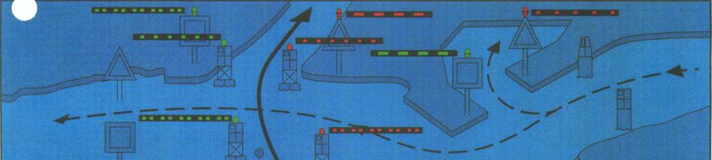
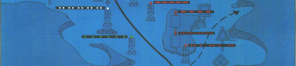
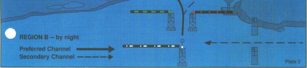
REGION B ONLY. Figure Figure Figure Figure Figure Figure Figure Figure 10.60
 221 REGION B ONLY 10.5 LATERAL MARKS 10.5.1 Description of Lateral marks Port hand marks Shape: pillar buoy (Figures 10.53 and 10.54), can lighted buoy (Figures 10.55 and 10.56) or not lighted (Figures
Provisions for Moorings
 Provisions for Moorings Tasman Resource Management Plan Summary Guide No. 11 Current: July 2013 1. Introduction Structures and occupation of the coastal marine area (CMA) are managed to control the location
National Maritime Center
 National Maritime Center Providing Credentials to Mariners (Sample Examination) Page 1 of 16 Choose the best answer to the following Multiple Choice Questions. 1. On U.S. charts, you can tell if a named
COXSWAIN NAVIGATION EXERCISES AUS197 NAME:
 COXSWAIN NAVIGATION EXERCISES AUS197 NAME: A deviation card is supplied at the end of this file. Check the answers Question 1 Using any chart (or use the AUS 197 extract) to: 1. Identify a distance of
Chartwork Learn the basics for position fixing using a number of techniques and a simple equation for speed, distance and time.
 Chartwork Learn the basics for position fixing using a number of techniques and a simple equation for speed, distance and time. Chartwork Chartwork Tools Accurate chart work is the basis for good navigation.
SAFETY AND RESCUE BOAT HANDLING EXAM B
 SAFETY AND RESCUE BOAT HANDLING EXAM B PO Box 1260 Portsmouth, RI 02871 Tel 401 683-0800 Fax 401 683-0840 powerboat@ussailing.org www.uspowerboating.com US POWERBOATING an affiliate of US SAILING SAFETY
Rules Practice Exam 7
 1 INTERNATIONAL ONLY The light which may be used with a vessel's whistle is to be. A. used when the whistle is broken B. used prior to sounding the whistle C. used only at night D. a white light 2 INTERNATIONAL
Letter Latitude Longitude A B C D E F G
 Co-ordinates Problem Using your dividers and the chartlet on the following page complete this table. Letter Latitude Longitude A B C D E F G Nautical Charts Review. Questions 1. A Mercator projection
SS&S Chapter 8 Instructor Guide
 SS&S Chapter 8 Instructor Guide The Rules of the Nautical Road The PowerPoints (PPT) slides for this SS&S chapter were copied from the BS&S-13 th Ed PPT because they are identical. Only the chapter numbers
Navigation & Orienteering: Pre- Test
 Name: Class: Answer Key Date: Page 1 of 7 Navigation & Orienteering: Pre- Test There are three sections: Multiple Choice, True/False, and Short Answer. For the multiple choice, please select the BEST answer
CREW BOOKLET. The Sea School P/L. (Sea School Certificate Level 1) Contents:
 Contents:") The Sea School P/L www.bluepeteraustralia.com ACN: 168709251 CREW BOOKLET (Sea School Certificate Level 1) Contents: Hopes and Concerns Crew Roles Program Outline Weather Tides Waves Minimal Impact Navigation
The Sea School P/L www.bluepeteraustralia.com ACN: 168709251 CREW BOOKLET (Sea School Certificate Level 1) Contents: Hopes and Concerns Crew Roles Program Outline Weather Tides Waves Minimal Impact Navigation
BookletChart. Entrance to San Francisco Bay NOAA Chart A reduced-scale NOAA nautical chart for small boaters
 BookletChart Entrance to San Francisco Bay NOAA Chart 18649 A reduced-scale NOAA nautical chart for small boaters When possible, use the full-size NOAA chart for navigation. Included Area Published by
Navigate in difficult or trackless areas
 Description This unit covers the knowledge and skills in off-road navigation in untracked areas in situations where extreme environmental conditions and/or poor visibility are not likely to occur. Objectives
ADANI PORTS & SEZ LTD. ++ MUNDRA PORT ++ GENERAL INFORMATION
 ADANI PORTS & SEZ LTD. ++ MUNDRA PORT ++ GENERAL INFORMATION LOCATION Mundra Port is all weather, independent, commercial port with geographical and hydrological advantages on the West Coast of India,
Rules Practice Exam 14
 1 BOTH INTERNATIONAL & INLAND Additional light signals are provided in the Annexes to the Rules for vessels. A. engaged in fishing B. not under command C. engaged in towing D. under sail 2 BOTH INTERNATIONAL
Wexford Harbour. Yachting Guide. Navigation
 Wexford Harbour Yachting Guide Navigation This document supersedes all previous editions. Approvals: Yacht Club Committee April, 2015 Wexford Board of Directors April, 2015 # Date Section Revision 1 6.5.2015
NOTICE TO MARINERS. No 03 of Port of Southampton Precautionary Area (Thorn Channel)
") NOTICE TO MARINERS No 03 of 2016 (Update and Re-Issue of Notice to Mariners No 03 of 2014) Port of Southampton Precautionary Area (Thorn Channel) 1 NOTICE IS HEREBY GIVEN that all vessels navigating within
NOTICE TO MARINERS No 03 of 2016 (Update and Re-Issue of Notice to Mariners No 03 of 2014) Port of Southampton Precautionary Area (Thorn Channel) 1 NOTICE IS HEREBY GIVEN that all vessels navigating within
Demonstrate basic knowledge of the operation of pleasure/small craft by day
 Page 1 of 7 Title Demonstrate basic knowledge of the operation of pleasure/small craft by day Level 2 Credits 6 Purpose This unit standard is for pleasure craft operators and covers knowledge required
SECTION I NM 5/17 CHART CORRECTIONS
 CHART CORRECTIONS 1116A 79Ed. 2/16 LAST NM 4/17 5/17 Delete Platform 28 22.9 N 90 32.1 W 11301 26Ed. 11/13 LAST NM 47/16 5/17 Delete Light 7 26 03 14 N 97 12 40 W 11302 34Ed. 1/14 LAST NM 15/16 5/17 (Side
Basic Chartwork. Necessary Tools. Navigation is the one science in which no margin whatever is left for the faker. - Felix Riesenberg
 Page 1 of 14 www.bananawind.us Navigation is the one science in which no margin whatever is left for the faker. - Felix Riesenberg Basic Chartwork You wouldn't want to attempt open ocean sailing using
NAV-COM OFFICER PREP FOR SEA CHECKLIST
 NAV-COM OFFICER o Radars are on and functioning properly o Both GPS units are on and functioning properly o Chart Plotter is on and functioning properly o VHF radios are on and functioning properly o VHF
BookletChart. Sand Key to Rebecca Shoal NOAA Chart A reduced-scale NOAA nautical chart for small boaters
 BookletChart Sand Key to Rebecca Shoal NOAA Chart 11439 A reduced-scale NOAA nautical chart for small boaters When possible, use the full-size NOAA chart for navigation. Published by the National Oceanic
What makes Ultra Anchor special?
 What makes Ultra Anchor special? Some sailors say that the value of the boat can be measured by its anchor. Some boaters believe that the vessel anchor is more important then its engine. Any boater who
Captain Jack Klang Sailboat Docking, Maneuvering and Anchoring
 Captain Jack Klang Sailboat Docking, Maneuvering and Anchoring Copyright, July 2002. All rights reserved. No portion may be reproduced in any manor without written permission of Jack Klang, Marine Consultant
National Maritime Center
 National Maritime Center Providing Credentials to Mariners (Sample Examination) Page 1 of 8 Choose the best answer to the following Multiple Choice Questions. 1. Assume that your vessel has just entered
WORKBOOK NAVIGATION Tr. For Power-driven and Sailing Vessels DAVID BURCH LARRY BRANDT
 Piloting Dead reckoning Special publications Lights and buoys Electronic fixes Chart reading and plotting Compass use Navigation Rules Tides and currents Depth sounding navigation STARPATH This book provides
Rocks, Wrecks, Obstructions, Aquaculture K
 General 1 Danger line: A danger line draws attention to a danger which would not stand out clearly enough if represented solely by its symbol (e.g. isolated rock) or delimits an area containing numerous
Port Sections Guide Section 01
 s Guide 01 Cow Bay Marina Date 10/1/2016 Position (lat / lon) Minimum controlled water depth Chart datum Range of water densities Tidal range alongside Bottom type Dredging regime Distance pilot station
Great Lakes Fleet CanDependence Cruise June 28 July 6, 2003
 Great Lakes Fleet CanDependence Cruise June 28 July 6, 2003 The images below are of various magnification and characteristics and should not be used in navigation. They are solely to be used in finding
Pilotage. Planning for pilotage
 Pilotage Planning for pilotage Being one step ahead of the game is key to effective pilotage. Only then will you know what to expect and what s lurking around the next bend. It s useful to construct a
REPORT OF INITIAL SURVEY OF AN UNKNOWN BARGE OFF OF CEDAR POINT, SANDUSKY, OHIO. July 26-27, Submitted to Cleveland Underwater Explorers, Inc.
 REPORT OF INITIAL SURVEY OF AN UNKNOWN BARGE OFF OF CEDAR POINT, SANDUSKY, OHIO July 26-27, 2008 Submitted to Cleveland Underwater Explorers, Inc. By Jack Papes SUBJECT Report of Initial survey of an unknown
MAC Transit Advisories as of April 30, 2018
 MAC Transit Advisories as of April 30, 2018 The Mariners Advisory Committee for the Bay and River Delaware was established in October 1964. Its members and associate members are mainly comprised of master
Homework 2 Bathymetric Charts [based on the Chauffe & Jefferies (2007)]
![Homework 2 Bathymetric Charts [based on the Chauffe & Jefferies (2007)]](/thumbs/75/72427079.jpg "Homework 2 Bathymetric Charts [based on the Chauffe & Jefferies (2007)]") 1 MAR 110 HW-2 - Bathy Charts Homework 2 Bathymetric Charts [based on the Chauffe & Jefferies (2007)] 2-1. BATHYMETRIC CHARTS Bathymetric charts are maps of a region of the ocean used primarily for navigation
1 MAR 110 HW-2 - Bathy Charts Homework 2 Bathymetric Charts [based on the Chauffe & Jefferies (2007)] 2-1. BATHYMETRIC CHARTS Bathymetric charts are maps of a region of the ocean used primarily for navigation
Berkeley Island Marine Pre-Rental Instructions. If you do not have a
 Berkeley Island Marine Pre-Rental Instructions. If you do not have a safe boating certificate or a boat license in the state of NJ, or an equivalent in another state, you must take this instruction. Approximate
UNITED NEW YORK SANDY HOOK PILOTS BENEVOLENT ASSOCIATION AND UNITED NEW JERSEY SANDY HOOK PILOTS BENEVOLENT ASSOCIATION
 UNITED NEW YORK SANDY HOOK PILOTS BENEVOLENT ASSOCIATION AND UNITED NEW JERSEY SANDY HOOK PILOTS BENEVOLENT ASSOCIATION TO: All Shipping Agents and Interested Parties January 19, 2017 SUBJECT: Anchorage
The Stonington Harbor Yacht Club Seventeenth Annual Red Lobdell Memorial Regatta Saturday, July 28, hours
 The Stonington Harbor Yacht Club Seventeenth Annual Red Lobdell Memorial Regatta Saturday, July 28, 2018 --- 1030 hours NOTICE OF RACE 1 Organizing Authority 1.1 This regatta is organized by the Stonington
The Holding Power of Anchors
 The Holding Power of Anchors G 1 Taylor The essential principle in the action of all anchors is that a surface set at an acute angle to the ground will dig in if pulled horizontally. In order that an anchor
Chapter IV - Sample Chart #1 Answers to Sample Chart #1
 Chapter IV - Sample Chart #1 Answers to Sample Chart #1 1. 29 10' N 2. 29 04' N 3. 28 57' N 4. 28 46' N 5. 28 38' N 6. 28 25' N 7. 28 17' N 8. 28 08' N 9. 27 51' N 10. 27 46' N Chapter IV - Sample Chart
For the love of the Vineyard and the sea Think Sail MV
 Youth Summer sailing syllabus For the love of the Vineyard and the sea Think Sail MV Racing Seamanship Gold Vondée Silver Volvo Bronze Sail Martha s Vineyard Youth sailing syllabus Clipper Swordfish Mackerel
Engineering Surveying - II CE313. Hydrographic Survey Lecture 06 Muhammad Noman
 Engineering Surveying - II CE313 Hydrographic Survey Lecture 06 Muhammad Noman Hydrographic Surveying Hydrographic surveying is the branch of the survey which deal with any body of still or running water
Hydrographic Surveying Methods, Applications and Uses
 Definition: Hydrographic Surveying Methods, Applications and Uses It is the branch of surveying which deals with any body of still or running water such as a lake, harbor, stream or river. Hydrographic
August April 18,2008 First Revision
 August 15 2011 Slide 01 April 18,2008 First Revision August 15, 2011 Text converted to Tables for ease of formatting instructor guide. Slide 23 Sound Signals Corrected Danger Signal 5 or More Short Blasts
Only launch your boat once you have a clear understanding of the most up-to-date weather forecast.
 Weather and Tides Observing the Weather Only launch your boat once you have a clear understanding of the most up-to-date weather forecast. Start with television and newspaper weather map reports; they
Essential Safety. in Chichester Harbour. An essential guide for the new or less experienced mariner
 Essential Safety in Chichester Harbour An essential guide for the new or less experienced mariner 01243 512301 www.conservancy.co.uk 1 Enjoying Chichester Harbour in safety Chichester Harbour is renowned
Figure 4, Photo mosaic taken on February 14 about an hour before sunset near low tide.
 The Impact on Great South Bay of the Breach at Old Inlet Charles N. Flagg and Roger Flood School of Marine and Atmospheric Sciences, Stony Brook University Since the last report was issued on January 31
Rope-less Fishing in Practice Today Ropeless Workshop Feb Woods Hole Oceanographic Institution. Michael Moore
 Rope-less Fishing in Practice Today Ropeless Workshop Feb 1 2018 Woods Hole Oceanographic Institution Michael Moore mmoore@whoi.edu Background To haul without endlines is a fundamental change in how most
ASA 103: Basic Coastal Cruising Curriculum
 ASA 103: Basic Coastal Cruising Curriculum Pre-study is vital to the success of your course. There will be two tests for this course, one written and one performance. Upon successful completion of this
U.S. Aids To Navigation System
 U.S. Aids To Navigation System Information provided by: United States Coast Guard, Office of Boating Safety (http://www.uscgboating.org/) AIDS TO NAVIGATION... ARE THE ROAD SIGNS OF THE WATERWAYS INTRODUCTION
Lesson 2: Sailing. A league is three nautical miles. (A nautical mile is about 800 feet longer than a mile on land.)
") Early Explorers -> 2: Sailing Lesson 2: Sailing Getting Started? Big Ideas What methods did sailors have for survival on the seas? & Facts and Definitions 8 Skills " Materials Introduction Navigation is
Early Explorers -> 2: Sailing Lesson 2: Sailing Getting Started? Big Ideas What methods did sailors have for survival on the seas? & Facts and Definitions 8 Skills " Materials Introduction Navigation is
Lab 5: Ocean Waves and Tides
 Lab 5: Ocean Waves and Tides Goals 1. Be able to identify the different characteristics of ocean waves 2. Understand lunar cycles 3. Importance of Tides I. Ocean Waves There are three physical characteristics
COAST GUARD ADVISORY NOTICE (CGAN ) To: Distribution Date: September 1, 2017
 To: Distribution Date: September 1, 2017") Commander United States Coast Guard Sector New York 212 Coast Guard Drive Staten Island, NY 10305 Staff Symbol: (spw) Phone: (718) 354-2353 Fax: (718) 354-4190 COAST GUARD ADVISORY NOTICE (CGAN 2017-016)
Commander United States Coast Guard Sector New York 212 Coast Guard Drive Staten Island, NY 10305 Staff Symbol: (spw) Phone: (718) 354-2353 Fax: (718) 354-4190 COAST GUARD ADVISORY NOTICE (CGAN 2017-016)
NavRule Practice Exam, 70 Series Practice April 24, Labeled F (I received a reply from the testing service that all these answers were
 1. INTERNATIONAL & INLAND An all-round flashing yellow light may be exhibited by a(n)? a. vessel laying cable b. vessel towing a submerged object c. vessel not under command d. air cushion vessel 2. INTERNATIONAL
BookletChart. Chesapeake Bay Severn and Magothy Rivers NOAA Chart A reduced-scale NOAA nautical chart for small boaters
 BookletChart Chesapeake Bay Severn and Magothy Rivers NOAA Chart 12282 A reduced-scale NOAA nautical chart for small boaters When possible, use the full-size NOAA chart for navigation. Published by the
Homework 2a Bathymetric Charts [based on the Chauffe & Jefferies (2007)]
![Homework 2a Bathymetric Charts [based on the Chauffe & Jefferies (2007)]](/thumbs/73/69074241.jpg "Homework 2a Bathymetric Charts [based on the Chauffe & Jefferies (2007)]") 14 August 2008 MAR 110 HW-2a: ex1bathymetric Charts 1 2-1. BATHYMETRIC CHARTS Homework 2a Bathymetric Charts [based on the Chauffe & Jefferies (2007)] Nautical charts are maps of a region of the ocean
14 August 2008 MAR 110 HW-2a: ex1bathymetric Charts 1 2-1. BATHYMETRIC CHARTS Homework 2a Bathymetric Charts [based on the Chauffe & Jefferies (2007)] Nautical charts are maps of a region of the ocean
Marine Kit 4 Marine Kit 4 Sail Smooth, Sail Safe
 Marine Kit 4 Marine Kit 4 Sail Smooth, Sail Safe Includes Basic ship Terminologies and Investigation Check list Index 1. Ship Terminology 03 2. Motions of a Floating Body...09 3. Ship Stability.10 4. Free
Rules Practice Exam 5
 1 BOTH INTERNATIONAL & INLAND Vessel "A" (towing) and vessel "B" are meeting as shown. In this situation, which statement is TRUE? Diagram 12 A. Both vessels should alter course to starboard and pass port
THEORY PRACTICE PAPER /
 THEORY PRACTICE PAPER http://www.uspowerboating.com / http://www.boatsafe.com http://www.singaporetests.com NAUTICAL TERMS 1. What does the term "draught of the vessel" mean :- a. depth of the vessel below
Gorgon - Pilotage - Passage Plan Materials Offloading Facility (MOF) to PBG
 to PBG") Gorgon - Pilotage - Passage Plan Materials Offloading Facility (MOF) to PBG 1.0 Introduction Vessels transiting within port limits from the Materials Offloading Facility (MOF) to the Barrow Island Pilot
Gorgon - Pilotage - Passage Plan Materials Offloading Facility (MOF) to PBG 1.0 Introduction Vessels transiting within port limits from the Materials Offloading Facility (MOF) to the Barrow Island Pilot
NavRule Practice Exam, 70 Series Practice April 18, Labeled C have been copied to collection
 1C. INTERNATIONAL & INLAND There are two classes of vessel which, to the extent necessary to carry out their work, do not have to comply with the rule regarding traffic separation schemes. One of these