FOR INFORMATION ONLY. Gold Coast Seaway Channel Scour and Rock Wall Stability Investigation. R.B doc December 2011
|
|
|
- Adam Myles Tate
- 5 years ago
- Views:
Transcription

1 A part of BMT in Energy and Environment Gold Coast Seaway Channel Scour and Rock Wall Stability Investigation R.B doc December 2011
2 Gold Coast Seaway Channel Scour and Rock Wall Stability Investigation Prepared For: Prepared By: Maritime Safety Queensland BMT WBM Pty Ltd (Member of the BMT group of companies) Offices Brisbane Denver Mackay Melbourne Newcastle Perth Sydney Vancouver
3 DOCUMENT CONTROL SHEET BMT WBM Pty Ltd BMT WBM Pty Ltd Level 8, 200 Creek Street Brisbane 4000 Queensland Australia PO Box 203 Spring Hill 4004 Tel: Fax: ABN Document : Project Manager : Client : R.B doc Malcolm Andrews Maritime Safety Queensland Client Contact: Client Reference John Bendel Title : Author : Synopsis : Gold Coast Seaway Channel Scour and Rock Wall Stability Investigation Malcolm Andrews The Gold Coast Seaway provides essential all-weather access from the Broadwater to the ocean. Concern has been felt that the continual scouring of the entrance, particularly near the training walls, may lower the factor of safety to critical levels. This report details the methodology and results of the investigation into the entrance scour and the current factor of safety on the rock walls. REVISION/CHECKING HISTORY REVISION NUMBER DATE OF ISSUE CHECKED BY ISSUED BY 0 06/12/2011 DCP MJA DISTRIBUTION DESTINATION MSQ BMT WBM File BMT WBM Library REVISION PDF PDF PDF
4 CONTENTS I CONTENTS Contents List of Figures i ii 1 INTRODUCTION METHODOLOGY ENTRANCE SCOUR Analysis Results GEOTECHNICAL ASSESSMENT FUTURE MONITORING CONCLUSIONS 6-1 APPENDIX A: GEOTECHNICAL REPORT A-1
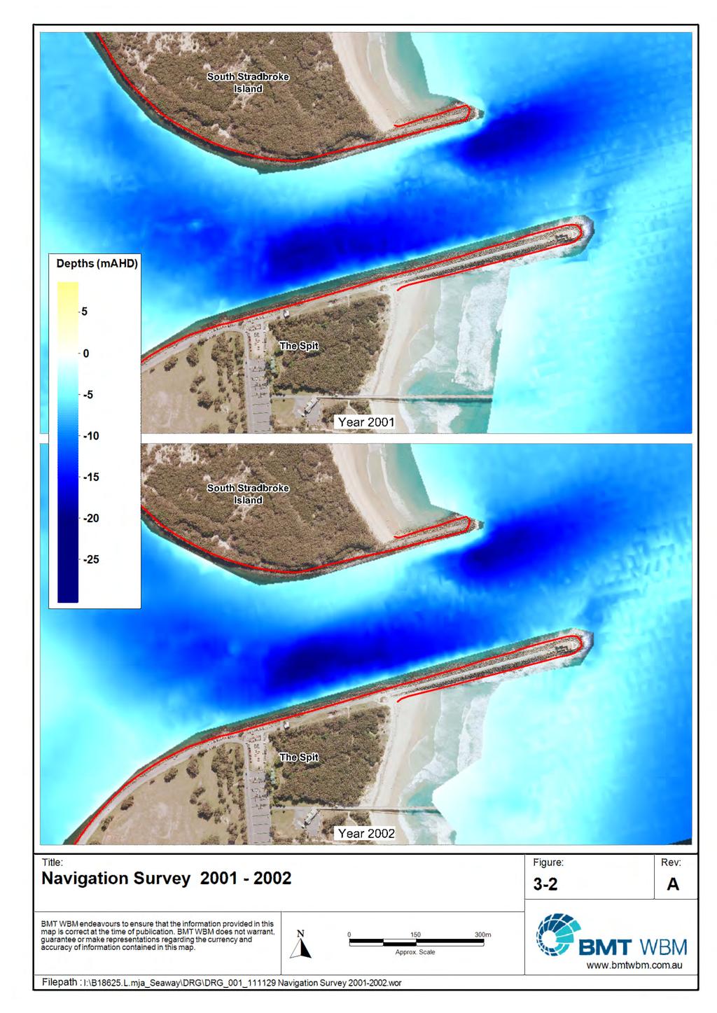
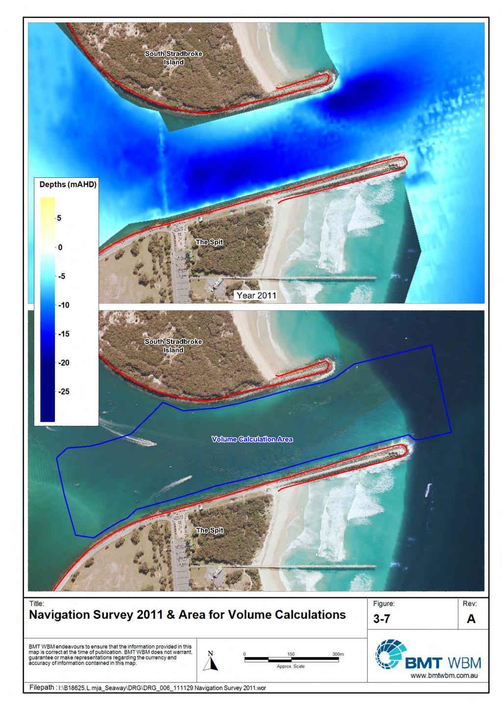
5 LIST OF FIGURES II LIST OF FIGURES Figure 3-1 Volume Change in the Seaway Entrance 3-1 Figure 3-2 Navigation Surveys Figure 3-3 Navigation Surveys Figure 3-4 Navigation Surveys Figure 3-5 Navigation Surveys Figure 3-6 Navigation Surveys Figure 3-7 Navigation Survey 2011 and Area for Volume Calculations 3-8 Figure 3-8 Difference Plots: & Figure 3-9 Difference Plots: & Figure 3-10 Difference Plots: & Figure 3-11 Difference Plots: & Figure 3-12 Difference Plots: & Figure 3-13 Difference Plots: &
6 INTRODUCTION INTRODUCTION The Gold Coast Seaway was constructed in 1986 to stabilise the Nerang River entrance and improve navigation. The works included constructing training walls south of the existing entrance, then simultaneously opening the new entrance and closing the old entrance. Immediately following the opening of the Seaway two scour holes began to develop within the entrance and there is concern that they may present a threat to the stability of the training walls. These holes have been continually monitored with regard to possible impacts on training wall stability. In 2001 WBM Oceanics investigated the stability of the training walls adjacent to the scour holes using Morrison Geotechnics as specialist sub-consultants. The conclusion from the investigation was that the training walls were geotechnically stable. BMT WBM has again been commissioned to review the stability of the training walls and have used Coffey Geotechnics as specialist consultants. This report details the methodology and results of a preliminary assessment of the current scour hole development and training wall stability.
7 METHODOLOGY METHODOLOGY The key assessments of ongoing entrance scour and training wall stability have been addressed by following investigations: Assessment of the historical navigation surveys and cross section profiles to give an indication of the trends of the scour holes both in a vertical direction (deepening) and spatially (broadening or migrating); Assessment of the stability and possible failure mode of the training walls at differing locations (foundation level and rock wall section changes) and for differing scour hole depths and side slopes; and The possible impacts of other factors such as sea level rise, increasing tidal velocities and redistribution of flows from the north and the south through the entrance.
8 ENTRANCE SCOUR ENTRANCE SCOUR 3.1 Analysis Historical entrance surveys and aerial photography have been captured as part of the monitoring program for the initial entrance works. These have been used to assess the historical changes in the entrance channel bed including the two scour hole developments. This has been done by creating digital terrain models (DTM s) on a GIS platform (MAPINFO) and initially colour coding according to depth. These plots are presented in Figures 3-2 to 3-7. Difference plots have also been made between each year as a further visual representation of the changes which are occurring. These plots are presented in Figures 3-8 and A further plot of the difference between 2001 and 2011 is given as Figure Results A volumetric analysis of the changes between survey dates in the entrance channel between Wavebreak Island and the eastern end of the breakwaters (refer Figure 3-7 for area) has been carried out using the DTM s. The results of this analysis, including the previous results from the 2001 report, are given in Figure 3-1 below. Figure 3-1 Volume Change in the Seaway Entrance The DTM plots and the volumetric analysis of the historical surveys indicate that the entrance scouring has slowed considerably from its historical rates. Annual fluctuations appear to be as high as 100,000m 3 ( ), and the recent average annual rate of scour is about 20,000m 3. The bed level and difference plots indicate that scour hole development occurred until about 1992 and extensive deepening of the main flow channel continued until about Since then the depth of the holes and the channel has slowed with some spatial extension of the channel deepening. The annual fluctuations are probably as a result of the conditions preceding the survey i.e. recent spring
9 ENTRANCE SCOUR 3-2 tides or flood flows could increase the depth and recent neap tides and some leaking of beach sand into the entrance could decrease depths. The scouring of the entrance channel is primarily related to the amount of flow through the entrance. Therefore, any factors, such as sea level rise, increasing tidal velocities and redistribution of flows from the north and the south through the entrance, which increase these flows (particularly in the north channel) are likely to exacerbate entrance scour with the impact related to the degree of the change. It is not known what lies at the base of the scour holes (approx. -20m LAT) but old geotechnical surveys of the entrance indicate that harder material (bedrock or indurated sand) exists at around this depth in the region. A thorough understanding of the sensitivity of the entrance to these changes could only be achieved by hydrodynamic and morphological modelling of the entrance. This modelling could also provide scenario analysis of any proposals to divert or re-balance flows around the entrance to reduce the asymmetry which causes the scour holes. Also, the presence of harder material could be included in the morphological modelling if this were carried out.
10
11
12
13
14
15
Gold Coast Broadwater
 Gold Coast Broadwater Preliminary Coastal and Hydrodynamic Investigations for Cruise Ship Terminal Options July 2013 Gold Coast Broadwater Preliminary Coastal and Hydrodynamic Investigations for Cruise
Jimmy s beach preliminary results
 Jimmy s beach preliminary results LP 668979 Jimmy s Beach Restoration Society 1 Outline 1. Long term: GIS analyses. Aerial photos, charts Shoreline analyses Storm data from MHL/DECC 2. Medium term: morphologic
COUPLED MANAGEMENT STRATEGY LAKE CATHIE ESTUARY & COAST
 Lake Cathie Progress Association Inc. ABN 28 251 433 854 P.O. Box 247 Lake Cathie NSW 2445 PHONE/FAX: 02 6584 8211 EMAIL: r3packag@bigpond.com 20 th October 2009 Port Macquarie Hastings Council PO Box
Request Number IR1-12: Flow Passage. Information Request
 Request Number IR1-12: Flow Passage Information Request Provide additional information about the 100 metre flow passage channel scenario between the Westshore Terminals and the proposed Project terminal
Figure 4, Photo mosaic taken on February 14 about an hour before sunset near low tide.
 The Impact on Great South Bay of the Breach at Old Inlet Charles N. Flagg and Roger Flood School of Marine and Atmospheric Sciences, Stony Brook University Since the last report was issued on January 31
Certified Professionals in Hydrographic Solutions
 Certified Professionals in Hydrographic Solutions Client Satisfaction is our Deliverable Port of Brisbane Pty Ltd Port Surveys Certified Professionals in Hydrographic Surveying Tel +61 (0) 7 3258 4820
Figure 1, Chart showing the location of the Breach at Old Inlet and sensors deployed in Great South Bay.
 The Impact on Great South Bay of the Breach at Old Inlet Charles N. Flagg and Roger Flood School of Marine and Atmospheric Sciences, Stony Brook University The Great South Bay project (http://po.msrc.sunysb.edu/gsb/)
Impacts of breakwaters and training walls
 Across the eastern seaboard of Australia, breakwaters and training walls have instigated fundamental perturbations to coastal and estuary processes. This has induced long-term changes to foreshore alignments,
INTRODUCTION TO COASTAL ENGINEERING
 The University of the West Indies Organization of American States PROFESSIONAL DEVELOPMENT PROGRAMME: COASTAL INFRASTRUCTURE DESIGN, CONSTRUCTION AND MAINTENANCE A COURSE IN COASTAL DEFENSE SYSTEMS I CHAPTER
THE HYDRAULIC AND MORPHOLOGICAL RESPONSE OF A LARGE COASTAL LAKE TO RISING SEA LEVELS
 THE HYDRAULIC AND MORPHOLOGICAL RESPONSE OF A LARGE COASTAL LAKE TO RISING SEA LEVELS Mr Evan K Watterson 1 Dr Joanna M Burston 1 Ms Heather Stevens 2 Mr Dan J Messiter 1 1 Author affiliation: WorleyParsons
6.4 a Coastal Inundation Study WBM
 6.4 a Coastal Inundation Study WBM Ella Bay Integrated Resort Development SEIS Submission Response Volume 6 Consultant and Ella Bay Reports BMT WBM Pty Ltd Level 8, 200 Creek Street Brisbane 4000 Queensland
C3 VOLUME C: MIDDLE BANKS, MORETON BAY. Coastal Processes and Natural Features NEW PARALLEL RUNWAY DRAFT EIS/MDP FOR PUBLIC COMMENT C3-42
 C3 VOLUME C: MIDDLE BANKS, MORETON BAY Coastal Processes and Natural Features C3-42 C3 VOLUME C: MIDDLE BANKS, MORETON BAY Coastal Processes and Natural Features CONTENTS 3.1 Introduction 48 3.2 Proposed
Implications of proposed Whanganui Port and lower Whanganui River dredging
 PO Box 637 Wanganui 4540 Attention: Rowan McGregor Dear Rowan 1 Summary We understand that it has been proposed to bring large vessels into the Port at Whanganui requiring the excavation of a channel up
: Hydrodynamic input for 2D Vessel Simulations (HY- 0027)
") Technical Note To : Christian Taylor (PoHDA) From : Rohan Hudson Cc : Ben Gray Date : 1/04/2015 (Final Draft) Subject : Hydrodynamic input for 2D Vessel Simulations (HY- 0027) Introduction This Technical
Technical Note To : Christian Taylor (PoHDA) From : Rohan Hudson Cc : Ben Gray Date : 1/04/2015 (Final Draft) Subject : Hydrodynamic input for 2D Vessel Simulations (HY- 0027) Introduction This Technical
FOR INFORMATION ONLY
 An investigation into the feasibility of piloting large cruise ships to and from a proposed terminal within the Gold Coast Broadwater Part A Simulation Plan Captain John Watkinson Meridian Maritime Services
CLAM PASS ANNUAL RESTORATION & MANAGEMENT PLAN TIDAL ANALYSIS ELEMENT REPORT NO. 13
 CLAM PASS ANNUAL RESTORATION & MANAGEMENT PLAN TIDAL ANALYSIS ELEMENT REPORT NO. 13 Submitted to: Pelican Bay Services Division Prepared by: Humiston & Moore Engineers H&M File No. 13-078 November 2012
Morphodynamics of Borssele Wind Farm Zone
 Morphodynamics of Borssele Wind Farm Zone Meeting Tender Borssele Hendrik Jan Riezebos Tommer Vermaas Robert Hasselaar Tim Raaijmakers 17 November 2014, SER Den Haag Contents of presentation Introduction
The Impact on Great South Bay of the Breach at Old Inlet Charles N. Flagg School of Marine and Atmospheric Sciences, Stony Brook University
 The Impact on Great South Bay of the Breach at Old Inlet Charles N. Flagg School of Marine and Atmospheric Sciences, Stony Brook University The previous report provided a detailed look at the conditions
LITTLE LAGOON & LITTLE LAGOON PASS: RESEARCH UPDATES & DIRECTIONS
 LITTLE LAGOON & LITTLE LAGOON PASS: RESEARCH UPDATES & DIRECTIONS Bret M. Webb, PhD, PE, DCE Professor Department of Civil, Coastal, and Environmental Engineering October 19, 2017 LLPS Meeting Acknowledgments
Currents measurements in the coast of Montevideo, Uruguay
 Currents measurements in the coast of Montevideo, Uruguay M. Fossati, D. Bellón, E. Lorenzo & I. Piedra-Cueva Fluid Mechanics and Environmental Engineering Institute (IMFIA), School of Engineering, Research
Investigation of the Impact of Beach Raking on Beach Accretion/Erosion: West End Beaches of Galveston Island, Texas 2007/ 2008
 Investigation of the Impact of Beach Raking on Beach Accretion/Erosion: West End Beaches of Galveston Island, Texas 2007/ 2008 By Robert Webster 1, Timothy Dellepenna Ph.D. 1, 1 Texas A&M at Galveston
4/06/2014. Need for Guidance. East Coast Lows. Catchment and coastal flood events can combine! Project 18 ARR Review
 Need for Guidance Development of Practical Guidance for Coincidence of Catchment Flooding and Oceanic Inundation Angela Toniato, NSW OEH Duncan McLuckie, NSW OEH Grantley Smith, Water Research Laboratory
Nearshore Morphodynamics. Bars and Nearshore Bathymetry. Sediment packages parallel to shore, that store beach sediment
 Nearshore Morphodynamics http://coastal.er.usgs.gov/bier/images/chandeleur-xbeach-lg.jpg Bars and Nearshore Bathymetry Sediment packages parallel to shore, that store beach sediment Can be up to 50 km
RAINBOW BAY FIELD REPORT
 RAINBOW BAY FIELD REPORT Contents Page Abstract 1.0 Introduction.. 2.0 Methodology 2.1 Limitations.. 3.0 Statement of Findings. 3.1 History. 3.2 Data Collection. 3.2.1 Observations. 3.2.2 Management Strategies
Shoreline Response to an Offshore Wave Screen, Blairgowrie Safe Boat Harbour, Victoria, Australia
 Shoreline Response to an Offshore Wave Screen, Blairgowrie Safe Boat Harbour, Victoria, Australia T.R. Atkins and R. Mocke Maritime Group, Sinclair Knight Merz, P.O. Box H615, Perth 6001, Australia ABSTRACT
VOLUME B: AIRPORT AND SURROUNDS Coastal Processes and Natural Features NEW PARALLEL RUNWAY DRAFT EIS/MDP FOR PUBLIC COMMENT B4-148
 B4 VOLUME B: AIRPORT AND SURROUNDS Coastal Processes and Natural Features B4-148 B4 VOLUME B: AIRPORT AND SURROUNDS Coastal Processes and Natural Features CONTENTS 4.1 Introduction 153 4.2 Proposed Development
STATUS REPORT FOR THE SUBMERGED REEF BALL TM ARTIFICIAL REEF SUBMERGED BREAKWATER BEACH STABILIZATION PROJECT FOR THE GRAND CAYMAN MARRIOTT HOTEL
 August 23 STATUS REPORT FOR THE SUBMERGED REEF BALL TM ARTIFICIAL REEF SUBMERGED BREAKWATER BEACH STABILIZATION PROJECT FOR THE GRAND CAYMAN MARRIOTT HOTEL performed by Lee E. Harris, Ph.D., P.E. Consulting
EVALUATION OF BEACH EROSION UP-DRIFT OF TIDAL INLETS IN SOUTHWEST AND CENTRAL FLORIDA, USA. Mohamed A. Dabees 1 and Brett D.
 EVALUATION OF BEACH EROSION UP-DRIFT OF TIDAL INLETS IN SOUTHWEST AND CENTRAL FLORIDA, USA Mohamed A. Dabees 1 and Brett D. Moore 1 The paper discusses the analysis of up-drift beach erosion near selected
Impact of Dredging the Lower Narrow River on Circulation and Flushing
 Impact of Dredging the Lower Narrow River on Circulation and Flushing Craig Swanson Ph.D. Swanson Environmental Alex Shaw Ocean Engineering, URI Prof. Malcolm L. Spaulding Ocean Engineering, URI 29 January
Follets Island Nearshore Beach Nourishment Project
 Coast & Harbor Engineering A division of Hatch Mott MacDonald Follets Island Nearshore Beach Nourishment Project Arpit Agarwal, P.E. April 1, 2016 Project Site!"#$% &'(% &)*+% )#,'-+% Shoreline Erosion
STUDY ON TSUNAMI PROPAGATION INTO RIVERS
 ABSTRACT STUDY ON TSUNAMI PROPAGATION INTO RIVERS Min Roh 1, Xuan Tinh Nguyen 2, Hitoshi Tanaka 3 When tsunami wave propagation from the narrow river mouth, water surface is raised and fluctuated by long
Tidal Amplitude and Wave Setup in Trained and Untrained River Entrances.
 Tidal Amplitude and Wave Setup in Trained and Untrained River Entrances. Theo Moura 1, Mohammad Olfateh 1, David Callaghan 1, Peter Nielsen 1, Bob You 2 and Tom Baldock 1 1 School of Civil Engineering,
Pre Feasibility Study Report Citiwater Cleveland Bay Purification Plant
 SOLAR POWER SPECIALISTS.Pure Power ACN 074 127 718 ABN 85 074 127 718 POWER MAGIC PTY LTD 245 INGHAM RD GARBUTT QLD 4814 Phone: 1800 068 977 Fax: 07 4725 2479 Email: FNQSOLAR@bigpond.com Pre Feasibility
Summary of HEC 18, Evaluating Scour at Bridges FHWA NHI Should really follow HEC 18, but this summary will get you the main points.
 Summary of HEC 18, Evaluating Scour at Bridges FHWA NHI 01-001 Should really follow HEC 18, but this summary will get you the main points. 1: Determine scour analysis variables 2: Analyze long-term bed
CLAM PASS RESTORATION AND MANAGEMENT PLAN BATHYMETRIC MONITORING REPORT NO. 7 Including Interior Bay Dredge Cuts and Tidal Data
 CLAM PASS RESTORATION AND MANAGEMENT PLAN BATHYMETRIC MONITORING REPORT NO. 7 Including Interior Bay Dredge Cuts and Tidal Data Submitted to: Florida Department of Environmental Protection DEP File No.
Estuary entrance changes in response to an environmental flow release
 University of Wollongong Research Online Faculty of Science, Medicine and Health - Papers Faculty of Science, Medicine and Health 2013 Estuary entrance changes in response to an environmental flow release
Modeling changes to the historic Lower Columbia River Estuary using Delft3D. Drew Mahedy Lumas Helaire Stefan Talke David Jay May 30, 2014
 Modeling changes to the historic Lower Columbia River Estuary using Delft3D Drew Mahedy Lumas Helaire Stefan Talke David Jay May 30, 2014 Comparison: Historic and Modern LCRE US Coastal Survey, 1868 Historic
America s Cup 36, Auckland 2021 Marine Traffic Survey
 Report America s Cup 36, Auckland 2021 Marine Traffic Survey for Resource Consent Application, Wynyard Basin Prepared for Panuku Development Auckland (Client) Prepared by Beca Ltd (Beca) January 2018 Revision
Bathymetry User Needs and Challenges in Australia and New Zealand
 Bathymetry User Needs and Challenges in Australia and New Zealand Nathan Quadros nquadros@crcsi.com.au Shallow Water Survey February 212 Background Recent significant investment in Bathymetric LiDAR acquisition
INVESTIGATING STRATEGIES TO REPAIR HISTORIC TIDE WALLS ON THE CLARENCE RIVER AND ADJACENT BEACH AND RIVER BANK PROTECTION
 INVESTIGATING STRATEGIES TO REPAIR HISTORIC TIDE WALLS ON THE CLARENCE RIVER AND ADJACENT BEACH AND RIVER BANK PROTECTION I Jayewardene 1, A Hartley 2, B Blumberg 1, E Couriel 1 1 NSW Water Solutions,
Cline s Point Marina Ship Wave Analysis
 Cline s Point Marina Ship Wave Analysis Draft Technical Report April 13, 2015 Submitted To: Port of Corpus Christi Authority Prepared for: Port of Corpus Christi Authority This document is intended for
Florida Seagrass Integrated Mapping and Monitoring Program
 Florida Seagrass Integrated Mapping and Monitoring Program - 2004 The following document is composed of excerpts taken from the 2011 publication, Seagrass Integrated Mapping and Monitoring for the State
Hydrographic Surveying Methods, Applications and Uses
 Definition: Hydrographic Surveying Methods, Applications and Uses It is the branch of surveying which deals with any body of still or running water such as a lake, harbor, stream or river. Hydrographic
SEAGRASS MAPPING FOR THE PENRHYN ESTUARY HABITAT ENHANCEMENT PLAN
 SEAGRASS MAPPING FOR THE PENRHYN ESTUARY HABITAT ENHANCEMENT PLAN PREPARED FOR SYDNEY PORTS CORPORATION By D. E. Roberts, S. R. Murray, G. R., Sainty August 2008 TABLE OF CONTENTS INTRODUCTION...3 METHODS...3
The Challenge of Wave Scouring Design for the Confederation Bridge
 13: Coastal and Ocean Engineering ENGI.8751 Undergraduate Student Forum Faculty of Engineering and Applied Science, Memorial University, St. John s, NL, Canada MARCH 2013 Paper Code. (13 - walsh) The Challenge
Welcome! Did You Know...? Aquatic Centre Dock Rebuild. Key Objectives
 1 Welcome! Aquatic Centre Dock Rebuild The City of Vancouver is improving the dock at the Vancouver Aquatic Centre, which is nearing the end of its service life and is in need of replacement. This creates
NCCOE EA Coastal Adaptation Guidelines. Section I Emerging Technology Novel Alternative Approaches to Coastal Erosion
 NCCOE EA Coastal Adaptation Guidelines Section I Emerging Technology Novel Alternative Approaches to Coastal Erosion Alessio Mariani, Doug Lord, Tony Webb James Carley, Matt Blacka, Brett Miller Ian Turner,
Mouth of the Columbia River Jetties Three-Phase Construction Plan
 Mouth of the Columbia River Jetties Three-Phase Construction Plan Project Overview October 9, 2012 US Army Corps of Engineers MCR Jetties Major Rehabilitation Sand Island pile dikes 1930-1935 Columbia
Geography of the Lower Fitzroy and navigation problems
 Geography of the Lower Fitzroy and navigation problems A topographic map of the Fitzroy estuary readily indicates why the Fitzroy River has proved difficult for shipping to negotiate. The river meanders
SWANSEA CHANNEL DREDGING TO IMPROVE NAVIGATION
 SWANSEA CHANNEL DREDGING TO IMPROVE NAVIGATION B.Morgan 1, G.Blumberg 1, A.Ling 2, H.Nelson 1 1 Royal HaskoningDHV, Sydney, NSW 2 NSW Department of Trade & Investment (Crown Lands), Newcastle, NSW Overview
REPORT. Skardon River Bauxite Project - Additional Coastal Assessment. Ports and Coastal Environmental Pty Ltd
 REPORT Skardon River Bauxite Project - Additional Coastal Assessment Client: Ports and Coastal Environmental Pty Ltd Reference: M&APA1066R001F01 Revision: 01/Final Date: 14 March 2016 HASKONING AUSTRALIA
Inlet Management Study for Pass-A-Grille and Bunces Pass, Pinellas County, Florida
 Inlet Management Study for Pass-A-Grille and Bunces Pass, Pinellas County, Florida Final Report Submitted By Ping Wang, Ph.D., Jun Cheng Ph.D., Zachary Westfall, and Mathieu Vallee Coastal Research Laboratory
HURRICANE SANDY LIMITED REEVALUATION REPORT UNION BEACH, NEW JERSEY DRAFT ENGINEERING APPENDIX SUB APPENDIX D SBEACH MODELING
 HURRICANE SANDY LIMITED REEVALUATION REPORT UNION BEACH, NEW JERSEY DRAFT ENGINEERING APPENDIX SUB APPENDIX D SBEACH MODELING Rev. 18 Feb 2015 1 SBEACH Modeling 1.0 Introduction Following the methodology
TWEED RIVER ENTRANCE AND BYPASS SEDIMENT DYNAMICS
 TWEED RIVER ENTRANCE AND BYPASS SEDIMENT DYNAMICS Ron Cox 1 and Dan Howe 1 A sediment budget analysis model was applied to the Tweed River entrance, and was used to evaluate different coastal management
LAKKOPETRA (GREECE) EUROSION Case Study. Contact: Kyriakos SPYROPOULOS. TRITON Consulting Engineers. 90 Pratinou Str Athens (GREECE)
 EUROSION Case Study. Contact: Kyriakos SPYROPOULOS. TRITON Consulting Engineers. 90 Pratinou Str Athens (GREECE)") LAKKOPETRA (GREECE) Contact: Kyriakos SPYROPOULOS TRITON Consulting Engineers 90 Pratinou Str. 11634 Athens (GREECE) Tel: +32 10 729 57 61 Fax: +32 10 724 33 58 e-mail: kspyropoulos@tritonsa.gr 19 1 1.
LAKKOPETRA (GREECE) Contact: Kyriakos SPYROPOULOS TRITON Consulting Engineers 90 Pratinou Str. 11634 Athens (GREECE) Tel: +32 10 729 57 61 Fax: +32 10 724 33 58 e-mail: kspyropoulos@tritonsa.gr 19 1 1.
Volume and Shoreline Changes along Pinellas County Beaches during Tropical Storm Debby
 Volume and Shoreline Changes along Pinellas County Beaches during Tropical Storm Debby Ping Wang and Tiffany M. Roberts Coastal Research Laboratory University of South Florida July 24, 2012 Introduction
CROSS-SHORE SEDIMENT PROCESSES
 The University of the West Indies Organization of American States PROFESSIONAL DEVELOPMENT PROGRAMME: COASTAL INFRASTRUCTURE DESIGN, CONSTRUCTION AND MAINTENANCE A COURSE IN COASTAL DEFENSE SYSTEMS I CHAPTER
CALCASIEU SALINITY STRUCTURES. HYDRODYNAMIC MODELING (To Support Design of Salinity Barriers)
") CALCASIEU SALINITY STRUCTURES HYDRODYNAMIC MODELING (To Support Design of Salinity Barriers) Presentation Overview 1 2 3 4 5 Project Overview and CEA Circulation Modeling Vessel Hydrodynamics Modeling
CALCASIEU SALINITY STRUCTURES HYDRODYNAMIC MODELING (To Support Design of Salinity Barriers) Presentation Overview 1 2 3 4 5 Project Overview and CEA Circulation Modeling Vessel Hydrodynamics Modeling
Visiting Lake Macquarie
 Visiting Lake Macquarie Lake Macquarie is the largest coastal salt water lake in Australia and is a prime boating destination for both small and large vessels. Many sailing regattas and fishing activities
Utilizing Vessel Based Mobile LiDAR & Bathymetry Survey Techniques for Survey of Four Southern California Breakwaters
 Utilizing Vessel Based Mobile LiDAR & Bathymetry Survey Techniques for Survey of Four Southern California Breakwaters Western Dredging Association: Pacific Chapter September 2012 Insert: Pipe Location
New Jersey Coastal Zone Overview. The New Jersey Beach Profile Network (NJBPN) 3 Dimensional Assessments. Quantifying Shoreline Migration
 3 Dimensional Assessments. Quantifying Shoreline Migration") New Jersey Coastal Zone Overview The New Jersey Beach Profile Network (NJBPN) Objectives Profile Locations Data Collection Analyzing NJBPN Data Examples 3 Dimensional Assessments Methodology Examples Quantifying
New Jersey Coastal Zone Overview The New Jersey Beach Profile Network (NJBPN) Objectives Profile Locations Data Collection Analyzing NJBPN Data Examples 3 Dimensional Assessments Methodology Examples Quantifying
NAVIGATION STUDY FOR LAKE WORTH INLET, FLORIDA DRAFT INTEGRATED FEASIBILITY REPORT AND ENVIRONMENTAL IMPACT STATEMENT APPENDIX A ENGINEERING
 NAVIGATION STUDY FOR LAKE WORTH INLET, FLORIDA DRAFT INTEGRATED FEASIBILITY REPORT AND ENVIRONMENTAL IMPACT STATEMENT APPENDIX A ENGINEERING NAVIGATION STUDY FOR LAKE WORTH INLET, FLORIDA DRAFT INTEGRATED
MODELLING THE SHORELINE IMPACTS OF RICHMOND RIVER TRAINING WALLS
 MODELLING THE SHORELINE IMPACTS OF RICHMOND RIVER TRAINING WALLS D Patterson 1 1 BMT WBM / University Of Qld, Brisbane, QLD Introduction The construction of river entrance training walls is generally aimed
Natural Mechanisms of Sediment Bypassing at Tidal Inlets
 Natural Mechanisms of Sediment Bypassing at Tidal Inlets by D. M. FitzGerald, N. C. Kraus, and E. B. Hands PURPOSE: The Coastal and Hydraulics Engineering Technical Note (CHETN) described herein describes
Beach profile surveys and morphological change, Otago Harbour entrance to Karitane May 2014 to June 2015
 Beach profile surveys and morphological change, Otago Harbour entrance to Karitane May 2014 to June 2015 Prepared for Port Otago Ltd Martin Single September 2015 Shore Processes and Management Ltd Contact
Earth Science Chapter 16 Section 3 Review
 Name: Class: Date: Earth Science Chapter 16 Section 3 Review Multiple Choice Identify the choice that best completes the statement or answers the question. 1. The movement of water that parallels the shore
Modelling and Assessment of Marine Renewable Energy Resources. Andrew Cornett Canadian Hydraulics Centre National Research Council Canada May 2008
 Modelling and Assessment of Marine Renewable Energy Resources Andrew Cornett Canadian Hydraulics Centre National Research Council Canada May 2008 Background Pan-Canadian resource inventory in 2005/06 Canada
Hydrodynamic and hydrological modelling to support the operation and design of sea ports
 Hydrodynamic and hydrological modelling to support the operation and design of sea ports Data needs and examples Martijn de Jong (port/nautical requirements, waves, currents) Sofia Caires (mean and extreme
OTC MS. Free Span Rectification by Pipeline Lowering (PL) Method N. I. Thusyanthan, K. Sivanesan & G. Murphy
 Method N. I. Thusyanthan, K. Sivanesan & G. Murphy") OTC-24699-MS Free Span Rectification by Pipeline Lowering (PL) Method N. I. Thusyanthan, K. Sivanesan & G. Murphy Copyright 2014, Offshore Technology Conference This paper was prepared for presentation
OTC-24699-MS Free Span Rectification by Pipeline Lowering (PL) Method N. I. Thusyanthan, K. Sivanesan & G. Murphy Copyright 2014, Offshore Technology Conference This paper was prepared for presentation
Low-crested offshore breakwaters: a functional tool for beach management
 Environmental Problems in Coastal Regions VI 237 Low-crested offshore breakwaters: a functional tool for beach management K. Spyropoulos & E. Andrianis TRITON Consulting Engineers, Greece Abstract Beach
CRC Inlet Management Study. Matt Slagel Shoreline Management Specialist
 CRC Inlet Management Study Matt Slagel Shoreline Management Specialist Study Origin CRC shall study feasibility of creating new AEC for lands adjacent to mouth of Cape Fear River (HB 819) Collaborate with
OFFICE OF STRUCTURES MANUAL FOR HYDROLOGIC AND HYDRAULIC DESIGN CHAPTER 11 APPENDIX B TIDEROUT 2 USERS MANUAL
 OFFICE OF STRUCTURES MANUAL FOR HYDROLOGIC AND HYDRAULIC DESIGN CHAPTER 11 APPENDIX B TIDEROUT 2 USERS MANUAL APRIL 2011 APRIL 2011 Page 1 Preface TIDEROUT 2, Build 1.22 dated June 29, 2006 is the current
Evaluation of Placement Alternatives for Matagorda Ship Channel Bottleneck Removal
 Evaluation of Placement Alternatives for Matagorda Ship Channel Bottleneck Removal James Rosati III Ashley E. Frey CPT Grays Harbor, WA Wood Wood chips Flour Other CMS Shark River Inlet, NJ US Army Corps
East Isa Airborne Electromagnetic Survey, QLD, 2016 Contractor supplied data and conductivity models
 East Isa Airborne Electromagnetic Survey, QLD, 2016 Contractor supplied data and conductivity models Geoscience Australia & Geological Survey of Queensland, Versatile Time Domain Electromagnetic (VTEM
COXSWAIN NAVIGATION EXERCISES AUS197 NAME:
 COXSWAIN NAVIGATION EXERCISES AUS197 NAME: A deviation card is supplied at the end of this file. Check the answers Question 1 Using any chart (or use the AUS 197 extract) to: 1. Identify a distance of
The rate versus time can then be the subject of whatever calculation the user chooses, for example:
 Using Neptune Planner Plus to Export Tidal Rates to Excel These notes are intended to assist the interested user in exporting predicted tidal stream rates into a spreadsheet for the estimation of tidal
Hydrographic Surveying at The Port of London
 Hydrographic Surveying at The Port of London John Dillon-Leetch Port and Terminal Technology 2009 14 th October, Antwerp Overview Introduction Surveying the Thames Navigational Charting High Resolution
ACOUSTIC DOPPLER CURRENT PROFILING FROM KIRRA BEACH TO COOK ISLAND FIELD EXERCISES UNDERTAKEN BY THE TWEED RIVER ENTRANCE SAND BYPASSING PROJECT
 ACOUSTIC DOPPLER CURRENT PROFILING FROM KIRRA BEACH TO COOK ISLAND FIELD EXERCISES UNDERTAKEN BY THE TWEED RIVER ENTRANCE SAND BYPASSING PROJECT Z Helyer 1, C Acworth 1, K Nielsen 1, 1 Coastal Impacts
Wave Setup at River and Inlet Entrances Due to an Extreme Event
 Proceedings of International Conference on Violent Flows (VF-2007) Organized by RIAM, Kyushu University, Fukuoka, Japan Wave Setup at River and Inlet Entrances Due to an Extreme Event Xuan Tinh Nguyen
Tanya M. Beck. Kelly Legault. Research Physical Scientist Coastal & Hydraulics Lab, ERDC Vicksburg, MS
 Inlet And Adjacent Shoreline Processes at Cascading Time Scales Using the Coastal Modeling System and GenCade Tanya M. Beck Research Physical Scientist Coastal & Hydraulics Lab, ERDC Vicksburg, MS Kelly
Your web browser (Safari 7) is out of date. For more security, comfort and the best experience on this site: Update your browser Ignore
 is out of date. For more security, comfort and the best experience on this site: Update your browser Ignore") Your web browser (Safari 7) is out of date. For more security, comfort and the best experience on this site: Update your browser Ignore TIDAL BO RE For the complete encyclopedic entry with media resources,
Your web browser (Safari 7) is out of date. For more security, comfort and the best experience on this site: Update your browser Ignore TIDAL BO RE For the complete encyclopedic entry with media resources,
COFFS HARBOUR SEDIMENT MODELLING AND INVESTIGATION
 COFFS HARBOUR SEDIMENT MODELLING AND INVESTIGATION Luke McAvoy Undergraduate Engineer (Civil) Griffith School of Engineering, Griffith University, Gold Coast, Australia Daniel Rodger Senior Engineer Water
Chapter 6: Santander case
 6 Santander case 6.1 Introduction Port activity in Santander dates back more than 2,000 years ago. Throughout this period, the sea and the port have been the fundamental elements of a community which,
Appendix 5: Currents in Minas Basin. (Oceans Ltd. 2009)
") Appendix 5: Currents in Minas Basin (Oceans Ltd. 29) Current in Minas Basin May 1, 28 March 29, 29 Submitted To: Minas Basin Pulp and Power P.O. Box 41 53 Prince Street Hansport, NS, BP 1P by 22, Purdy
Appendix 5: Currents in Minas Basin (Oceans Ltd. 29) Current in Minas Basin May 1, 28 March 29, 29 Submitted To: Minas Basin Pulp and Power P.O. Box 41 53 Prince Street Hansport, NS, BP 1P by 22, Purdy
Coastal Hazards Study
 Coastal Hazards Study 2212 Beach Boulevard, Pacifica Prepared for: EXECUTIVE SUMMARY City of Pacifica 170 Santa Maria Ave Pacifica, CA 94044 Prepared by: moffatt & nichol 2185 N. California Blvd. Walnut
APPENDIX D-2. Sea Level Rise Technical Memo
 APPENDIX D-2 Sea Level Rise Technical Memo 2185 N. California Blvd., Suite 500 Walnut Creek, CA 94596 (925) 944-5411 Fax: (925) 944-4732 www.moffattnichol.com DRAFT MEMORANDUM To: From: Neil Nichols,
Wave-dominated embayed beaches. Andrew D Short School of Geosciences University of Sydney
 Wave-dominated embayed beaches Andrew D Short School of Geosciences University of Sydney Wave-dominated embayed beaches wave-dominated beaches embayed beaches morphodynamics of W-D embayed beaches circulation,
Advanced Series on Ocean Engineering - Volume 14 COASTAL STABILIZATION. Richard Silvester John R C Hsu. \v? World Scientific
 Advanced Series on Ocean Engineering - Volume 14 COASTAL STABILIZATION Richard Silvester John R C Hsu \v? World Scientific Contents PREFACE xv 1 INTRODUCTION 1 /. / Coastal Environment 2 J.2 State of Beach
APPENDIX C. Fluvial and Tidal Hydraulics Report
 APPENDIX C Fluvial and Tidal Hydraulics Report BUENA VISTA LAGOON ENHANCEMENT PROJECT FLUVIAL AND TIDAL HYDRAULICS ANALYSES Prepared for: SANDAG 401 B Street, Suite 800 San Diego, California 92101 Contact:
MESSOLOGI LAGOON AREA (GREECE)
") MESSOLOGI LAGOON AREA (GREECE) 20 Contact: Kyriakos SPYROPOULOS TRITON Consulting Engineers 90 Pratinou Str. 11634 Athens (GREECE) Tel: +32 10 729 57 61 Fax: +32 10 724 33 58 e-mail: kspyropoulos@tritonsa.gr
MESSOLOGI LAGOON AREA (GREECE) 20 Contact: Kyriakos SPYROPOULOS TRITON Consulting Engineers 90 Pratinou Str. 11634 Athens (GREECE) Tel: +32 10 729 57 61 Fax: +32 10 724 33 58 e-mail: kspyropoulos@tritonsa.gr
INTRODUCTION TO COASTAL ENGINEERING AND MANAGEMENT
 Advanced Series on Ocean Engineering Volume 16 INTRODUCTION TO COASTAL ENGINEERING AND MANAGEMENT J. William Kamphuis Queen's University, Canada World Scientific Singapore New Jersey London Hong Kong Contents
A part of BMT in Energy and Environment Woorim Beach Shoreline Erosion Management Plan
 A part of BMT in Energy and Environment Woorim Beach Shoreline Erosion Management Plan R.B16200.001.03.doc September 2007 Woorim Beach Shoreline Erosion Management Plan Prepared For: Prepared By: Caboolture
environmentaldefender s office ltd new south wales
 environmentaldefender s office ltd new south wales TURNING THE TIDE EXHIBITION LAUNCH 21 November 2005 THE IMPACTS OF SHARK MESHING ON THREATENED SPECIES The EDO Mission Statement To empower the community
Chapter 4 EM THE COASTAL ENGINEERING MANUAL (Part I) 1 August 2008 (Change 2) Table of Contents. Page. I-4-1. Background...
 1 August 2008 (Change 2) Table of Contents. Page. I-4-1. Background...") Chapter 4 EM 1110-2-1100 THE COASTAL ENGINEERING MANUAL (Part I) 1 August 2008 (Change 2) Table of Contents I-4-1. Background... Page I-4-1 a. Shore Protection Planning and Design, TR 4... I-4-1 b. Shore
Chapter 4 EM 1110-2-1100 THE COASTAL ENGINEERING MANUAL (Part I) 1 August 2008 (Change 2) Table of Contents I-4-1. Background... Page I-4-1 a. Shore Protection Planning and Design, TR 4... I-4-1 b. Shore
Click to edit Master title style Advanced Military Layers. and the Historic Environment
 Advanced Military Layers and the Historic Environment Paul Baggaley and Louise Tizzard Wessex Archaeology 1 Click to edit Objectives Master title style to establish the degree of mutual benefit in integrating
Cross-shore sediment transports on a cut profile for large scale land reclamations
 Cross-shore sediment transports on a cut profile for large scale land reclamations Martijn Onderwater 1 Dano Roelvink Jan van de Graaff 3 Abstract When building a large scale land reclamation, the safest
Discussion on the Selection of the Recommended Fish Passage Design Discharge
 Discussion on the Selection of the Recommended Fish Passage Design Discharge Introduction The provision of fish passage is a requirement for most proposed culvert and bridge installations in Alberta, depending
West Cliff Colliery Longwall Subsidence Management Plan Variation Reduction in Longwall 34 void length.
 Illawarra Coal 26 The Director-General Industry & Investment NSW Mineral Resources PO Box 344 Hunter Region Mail Centre NSW 2310 Illawarra Coal Holdings Pty Ltd BHP Billiton Illawarra Coal Administration
Assessment of Baseline Geomorphic Features at. Proposed Stream Crossings On The Proposed County Road 595. Marquette County, Michigan
 Assessment of Baseline Geomorphic Features at Proposed Stream Crossings On The Proposed County Road 595 Marquette County, Michigan Prepared for: Kennecott Eagle Minerals Company Marquette, Michigan Prepared
Chapter - Oceans and Coasts
 Chapter - Oceans and Coasts Discussion: What do oceans contribute to the environment of Earth? How do Earth s major systems relate to the oceans? Oceans and Coasts Oceans are important - Thermal regulation