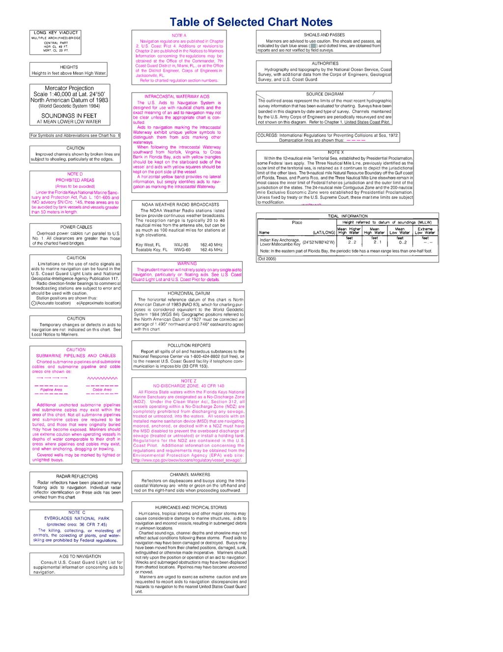
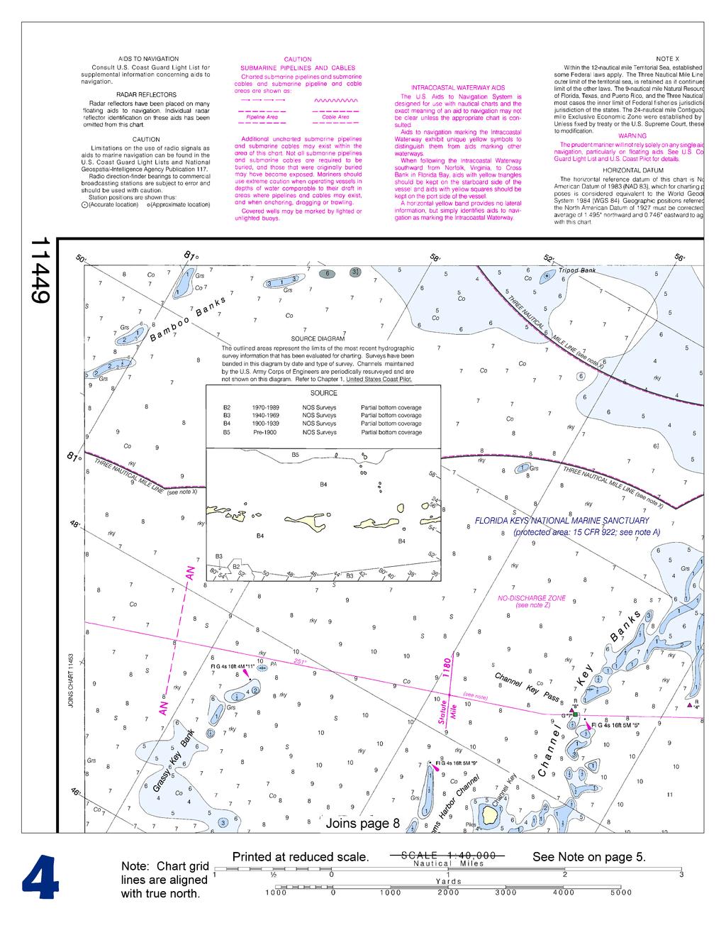
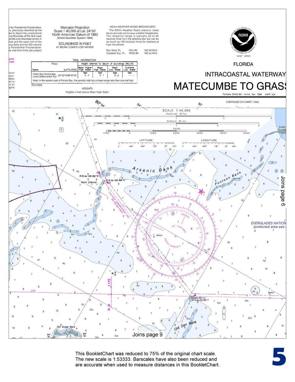
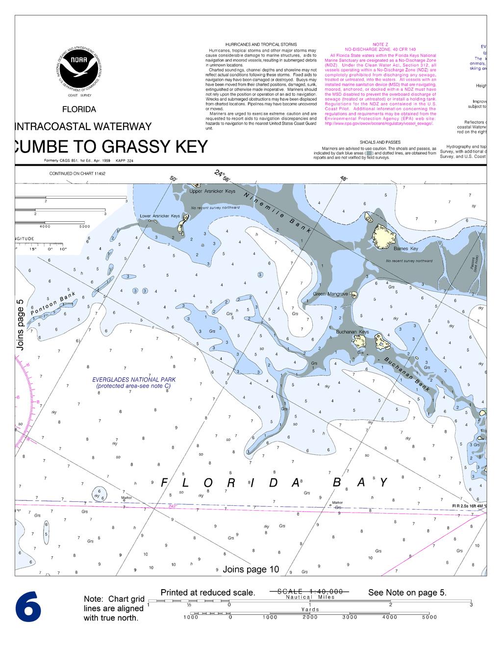
BookletChart. Intracoastal Waterway Matecumbe to Grassy Key NOAA Chart A reduced-scale NOAA nautical chart for small boaters
|
|
|
- Myra Price
- 5 years ago
- Views:
Transcription


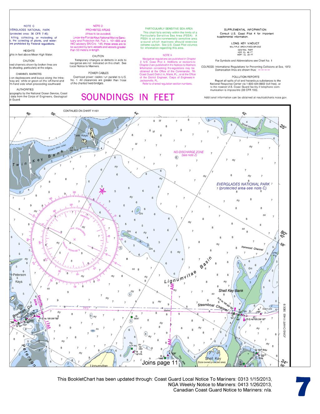
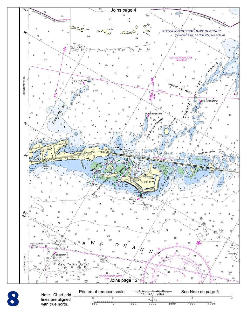
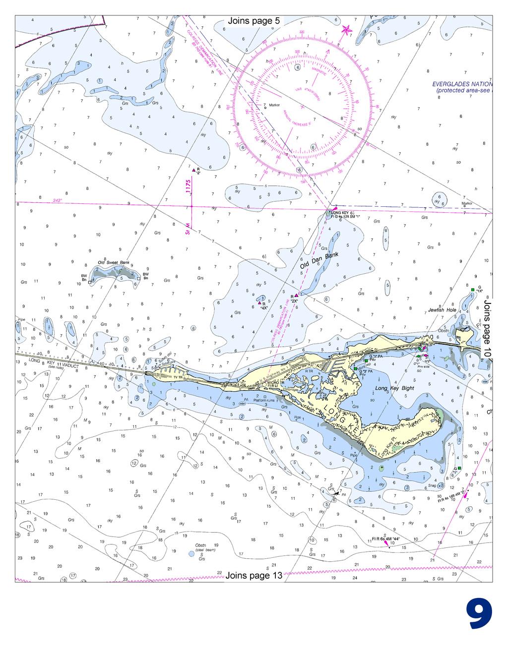
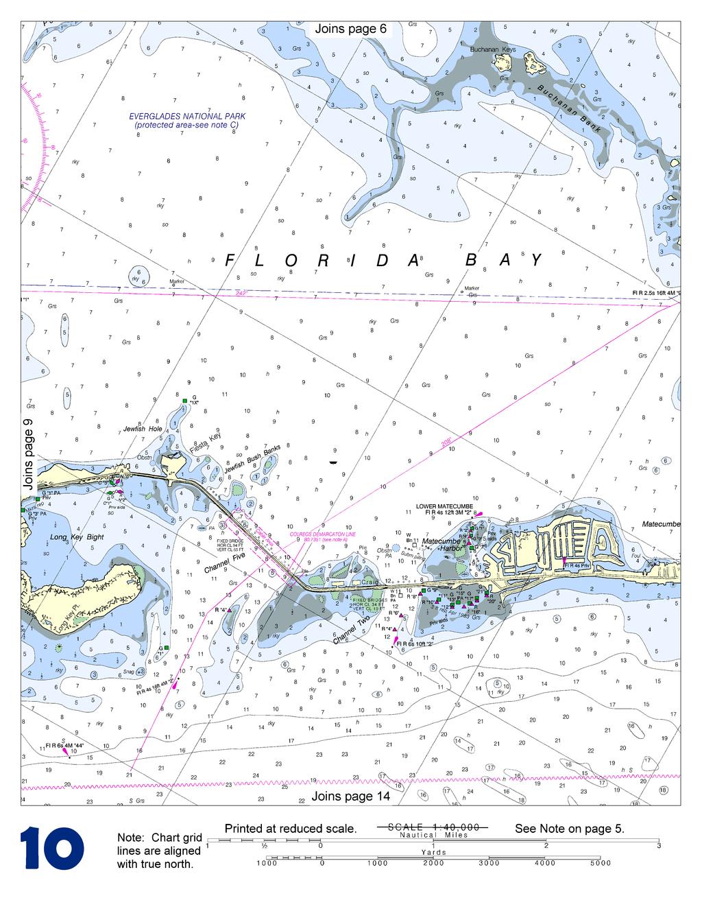
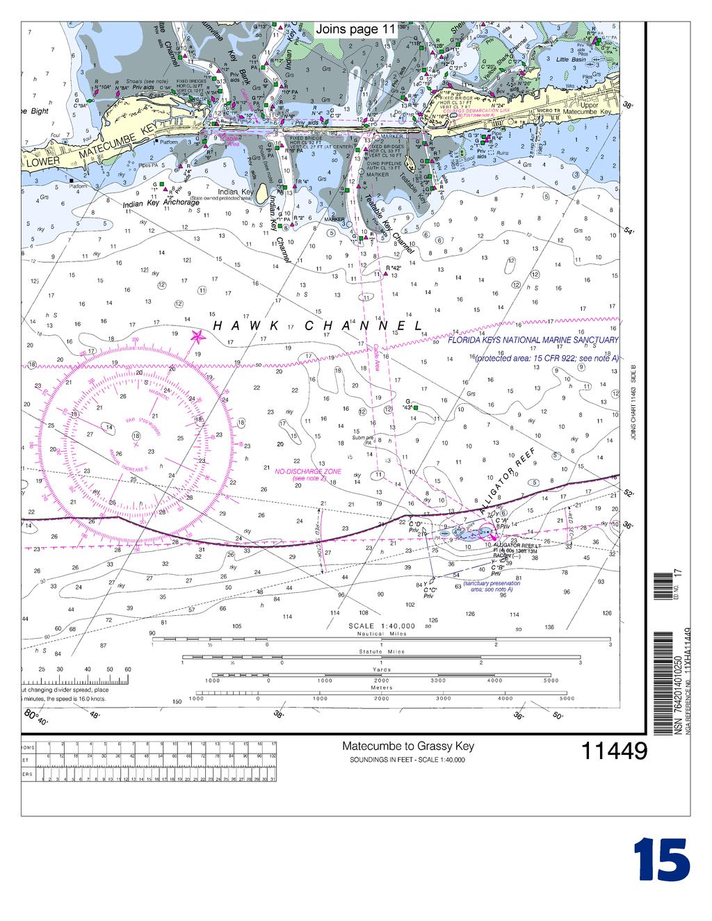
1 BookletChart Intracoastal Waterway Matecumbe to Grassy Key NOAA Chart A reduced-scale NOAA nautical chart for small boaters When possible, use the full-size NOAA chart for navigation.

2 Published by the National Oceanic and Atmospheric Administration National Ocean Service Office of Coast Survey NOAA What are Nautical Charts? Nautical charts are a fundamental tool of marine navigation. They show water depths, obstructions, buoys, other aids to navigation, and much more. The information is shown in a way that promotes safe and efficient navigation. Chart carriage is mandatory on the commercial ships that carry America s commerce. They are also used on every Navy and Coast Guard ship, fishing and passenger vessels, and are widely carried by recreational boaters. What is a BookletChart? This BookletChart is made to help recreational boaters locate themselves on the water. It has been reduced in scale for convenience, but otherwise contains all the information of the full-scale nautical chart. The bar scales have also been reduced, and are accurate when used to measure distances in this BookletChart. See the Note at the bottom of page 5 for the reduction in scale applied to this chart. Whenever possible, use the official, full scale NOAA nautical chart for navigation. Nautical chart sales agents are listed on the Internet at This BookletChart does NOT fulfill chart carriage requirements for regulated commercial vessels under Titles 33 and 44 of the Code of Federal Regulations. Notice to Mariners Correction Status This BookletChart has been updated for chart corrections published in the U.S. Coast Guard Local Notice to Mariners, the National Geospatial Intelligence Agency Weekly Notice to Mariners, and, where applicable, the Canadian Coast Guard Notice to Mariners. Additional chart corrections have been made by NOAA in advance of their publication in a Notice to Mariners. The last Notices to Mariners applied to this chart are listed in the Note at the bottom of page 7. Coast Pilot excerpts are not being corrected. For latest Coast Pilot excerpt visit the Office of Coast Survey website at (Selected Excerpts from Coast Pilot) Alligator Reef Light (24 51'06"N., 80 37'08"W.), 136 feet above the water, is shown from a white, octagonal pyramidal skeleton tower with black top, on pile foundation, enclosing a square dwelling and stair cylinder. Indian Key Channel, northwestward of Alligator Reef Light, is about 200 yards wide and leads from the Straits of Florida east of Lignumvitae Key to Florida Bay. It is marked by daybeacons. In 1983, the reported controlling depth in this narrow channel was 6 feet. It was also reported that the channel has a tendency to deepen with westerly winds and fill in with southeasterly winds. Local knowledge is advised. The highway bridge across the channel has a fixed span with a clearance of 27 feet. Channel Five, 8.4 miles westward of Alligator Reef Light, is a natural channel that had a reported controlling depth of 7 feet in At times a strong current sets through the channel. The fixed highway bridge across the channel has a clearance of 65 feet. Vessels drawing up to three feet can follow the marked route leading westward and northwestward in Florida Bay to Cape Sable and Flamingo. Flamingo, on the north side of Florida Bay about 9 miles east of East Cape (25 07'N., 81 05'W.), is a visitors center in Everglades National Park. (See chart for Everglades National Park.) A 300-foot tower and an 86-foot standpipe about 0.3 mile northeast of the visitors center are prominent. A dredged channel leads from the bay to the entrance to Buttonwood (Flamingo) Canal. The reported controlling depth was 4½ feet in A dam blocks the canal about 200 yards above the entrance. Passage around the dam to allow vessels to proceed to Whitewater Bay is provided by boat ramps and by an 8-ton sling hoist that can handle craft to 26 feet with 10-foot beam. A highway bridge about 0.5 mile above the entrance to the canal has a 45-foot fixed span with a clearance of 10 feet. A marina on the west side of the canal just below the dam at Flamingo has berths with electricity, water, ice, and limited marine supplies. Gasoline, diesel fuel, and launching ramps are available on either side of the dam. A 5 mph-no wake speed limit is enforced in the canal. Tennessee Reef Light (24 44'46"N., 80 46'56"W.), 49 feet above the water, is shown from a small black house on a hexagonal, pyramidal skeleton tower on piles, about 0.7 mile off the southwestern end of Tennessee Reef. A lighted buoy is about 5.6 miles northeast of the light. Long Key Anchorage, 3 miles north-northwestward of Tennessee Reef Light, has soft bottom in depths of 15 to 18 feet, but it is exposed to southerly winds. In 1982, a partially submerged steel beam was reported 2.8 miles northwest of Tennessee Reef Light in about 'N., 'W. Turtle Shoal Anchorage, 20 miles southwestward of Alligator Reef Light and 1 mile westward of East Turtle Shoal Light 45 (24 43'29"N., 80 55'59"W.), 20 feet above the water, has a soft bottom in a depth of 27 feet. It is a fair anchorage in fine weather. West Turtle Shoal to the southwestward affords another anchorage area in depths of 24 to 36 feet about 1 mile to its westward. A 1-mile-square fish haven is immediately southward of West Turtle Shoal. A well-protected yacht basin and a marina are at Duck Key, about 3 miles north-northeastward of East Turtle Shoal Light 45. A private light and private daybeacons mark the channel entrance to Duck Key. In 1983, a reported depth of 10 feet could be carried to the yacht basin, thence 5 feet to the marina beyond. Berths, electricity, gasoline, diesel fuel, and water are available at the yacht basin and marina. A launching ramp, ice, and marine supplies are also available at the marina. Hotels and restaurants are nearby. Valhalla on Crawl Key, about 3 miles northwestward of East Turtle Shoal Light 45, has a private yacht club. Key Colony Beach, about 3 miles southwestward of Valhalla, is a protected harbor westward of Fat Deer Key. In 2000, the reported controlling depth was 9 feet in the entrance channel. The channel is marked by private daybeacons. Gasoline, diesel fuel, water, berthing with electricity, and a launching ramp are available. 2 U.S. Coast Guard Rescue Coordination Center 24 hour Regional Contact for Emergencies RCC Miami Commander 7th CG District (305) Miami, FL
3
4
5
6
7
8
9
10
11
12
13
14
15


16 VHF Marine Radio channels for use on the waterways: Channel 6 Inter-ship safety communications. Channel 9 Communications between boats and ship-to-coast. Channel 13 Navigation purposes at bridges, locks, and harbors. EMERGENCY INFORMATION Channel 16 Emergency, distress and safety calls to Coast Guard and others, and to initiate calls to other vessels. Contact the other vessel, agree to another channel, and then switch. Channel 22A Calls between the Coast Guard and the public. Severe weather warnings, hazards to navigation and safety warnings are broadcast here. Channels 68, 69, 71, 72 and 78A Recreational boat channels. Getting and Giving Help Signal other boaters using visual distress signals (flares, orange flag, lights, arm signals); whistles; horns; and on your VHF radio. You are required by law to help boaters in trouble. Respond to distress signals, but do not endanger yourself. Distress Call Procedures Make sure radio is on. Select Channel 16. Press/Hold the transmit button. Clearly say: MAYDAY, MAYDAY, MAYDAY. Also give: Vessel Name and/or Description; Position and/or Location; Nature of Emergency; Number of People on Board. Release transmit button. Wait for 10 seconds If no response Repeat MAYDAY call. HAVE ALL PERSONS PUT ON LIFE JACKETS! NOAA Weather Radio All Hazards (NWR) is a nationwide network of radio stations broadcasting continuous weather information directly from the nearest National Weather Service office. NWR broadcasts official Weather Service warnings, watches, forecasts and other hazard information 24 hours a day, 7 days a week. Quick References Nautical chart related products and information - Online chart viewer - Report a chart discrepancy - Chart and chart related inquiries and comments - Chart updates (LNM and NM corrections) - QR Coast Pilot online - Tides and Currents - Marine Forecasts - National Data Buoy Center - NowCoast web portal for coastal conditions - National Weather Service - National Hurrican Center - Pacific Tsunami Warning Center - Contact Us - For the latest news from Coast Survey, This Booklet chart has been designed for duplex printing (printed on front and back of one sheet). If a duplex option is not available on your printer, you may print each sheet and arrange them back-to-back to allow for the proper layout when viewing. NOAA s Office of Coast Survey The Nation s Chartmaker
BookletChart. Sand Key to Rebecca Shoal NOAA Chart A reduced-scale NOAA nautical chart for small boaters
 BookletChart Sand Key to Rebecca Shoal NOAA Chart 11439 A reduced-scale NOAA nautical chart for small boaters When possible, use the full-size NOAA chart for navigation. Published by the National Oceanic
BookletChart. Chesapeake Bay Tangier Sound, Northern Part NOAA Chart A reduced-scale NOAA nautical chart for small boaters
 BookletChart Chesapeake Bay Tangier Sound, Northern Part NOAA Chart 12231 A reduced-scale NOAA nautical chart for small boaters When possible, use the full-size NOAA chart for navigation. Published by
BookletChart. Chesapeake Bay Severn and Magothy Rivers NOAA Chart A reduced-scale NOAA nautical chart for small boaters
 BookletChart Chesapeake Bay Severn and Magothy Rivers NOAA Chart 12282 A reduced-scale NOAA nautical chart for small boaters When possible, use the full-size NOAA chart for navigation. Published by the
BookletChart. Entrance to San Francisco Bay NOAA Chart A reduced-scale NOAA nautical chart for small boaters
 BookletChart Entrance to San Francisco Bay NOAA Chart 18649 A reduced-scale NOAA nautical chart for small boaters When possible, use the full-size NOAA chart for navigation. Included Area Published by
SECTION II NM 11/13 NAVIGATION PUBLICATIONS COAST PILOT CORRECTIONS. Chapter 4 Paragraphs 85 to 86; read: (85)
") NAVIGATION PUBLICATIONS COAST PILOT CORRECTIONS COAST PILOT 1 42 Ed 2012 Change No. 13 LAST NM 9/13 Chapter 4 Paragraph 9; read: (9) Round Rock, which uncovers, and The Boring Stone, 3 feet high and bare,
NAVIGATION PUBLICATIONS COAST PILOT CORRECTIONS COAST PILOT 1 42 Ed 2012 Change No. 13 LAST NM 9/13 Chapter 4 Paragraph 9; read: (9) Round Rock, which uncovers, and The Boring Stone, 3 feet high and bare,
U. S. Coast Guard Sector Boston Merrimack River Approach and Entrance, MA. Waterways Management Survey
 U. S. Coast Guard Sector Boston Merrimack River Approach and Entrance, MA. Waterways Management Survey The Waterways Analysis and Management Survey (WAMS) process is an essential component of both the
 Page 1 of 6 Nav-Aid Basics Unlike the roads and highways that we drive on, the waterways we go boating on do not have road signs that tell us our location, the route or distance to a destination, or of
SECTION II NM 26/10 NAVIGATION PUBLICATIONS ALMANACS CORRECTIONS
 NAVIGATION PUBLICATIONS ALMANACS CORRECTIONS NAUTICAL ALMANAC Ed 2011 NEW EDITION (NGA) 26/10 SAILING DIRECTIONS CORRECTIONS PUB 140 8 Ed 2010 NEW EDITION (NGA) 26/10 COAST PILOT CORRECTIONS COAST PILOT
The LA/LB Harbors handle more than 5,500 commercial vessel arrivals per year (excluding local coastwise and Catalina Island traffic).
.") X. SMALL CRAFT For the purpose of the Los Angeles and Long Beach Harbor Safety Plan, pleasure vessels, commercial fishing vessels and sportfishing boats are designated as small craft. A. BACKGROUND: The
X. SMALL CRAFT For the purpose of the Los Angeles and Long Beach Harbor Safety Plan, pleasure vessels, commercial fishing vessels and sportfishing boats are designated as small craft. A. BACKGROUND: The
Wexford Harbour. Yachting Guide. Navigation
 Wexford Harbour Yachting Guide Navigation This document supersedes all previous editions. Approvals: Yacht Club Committee April, 2015 Wexford Board of Directors April, 2015 # Date Section Revision 1 6.5.2015
INTER CLUB SERIES SAILING INSTRUCTIONS
 INTER CLUB SERIES - 2011 SAILING INSTRUCTIONS 1. RULES The regatta will be governed by the Racing Rules of Sailing (RRS), 2009-2012 including the January 2010 amendments, the prescriptions of U.S. Sailing
SECTION II NM 38/12 NAVIGATION PUBLICATIONS. Chapter 8 Paragraph 357; read: (357) COAST PILOT CORRECTIONS
 COAST PILOT CORRECTIONS") NAVIGATION PUBLICATIONS COAST PILOT CORRECTIONS COAST PILOT 1 42 Ed 2012 Change No. 4 LAST NM 35/12 Appendix A Paragraph 136; read: (136) NAVTEX coverage is reasonably continuous to 200 NM off the U.S.
NAVIGATION PUBLICATIONS COAST PILOT CORRECTIONS COAST PILOT 1 42 Ed 2012 Change No. 4 LAST NM 35/12 Appendix A Paragraph 136; read: (136) NAVTEX coverage is reasonably continuous to 200 NM off the U.S.
GULF OF MEXICO. 268 U.S. Coast Pilot 5, Chapter 6 04 AUG (see catalog for complete coverage) General Index of Chart Coverage in Chapter 6
 General Index of Chart Coverage in Chapter 6") 268 U.S. Coast Pilot 5, Chapter 6 04 AUG 2013 General Index of Chart Coverage in Chapter 6 (see catalog for complete coverage) 11406 11405 11404 11383 11384 11382 11388 11392 11391 11389 11390 11393 88
268 U.S. Coast Pilot 5, Chapter 6 04 AUG 2013 General Index of Chart Coverage in Chapter 6 (see catalog for complete coverage) 11406 11405 11404 11383 11384 11382 11388 11392 11391 11389 11390 11393 88
SECTION XI - COAST PILOT UPDATING. 1. To acquire a general knowledge of the responsibilities of the Auxiliary in COAST PILOT UPDATING activities.
 SECTION XI - COAST PILOT UPDATING INTRODUCTION: The United States Coast Pilot published by the NOS-C&GS, is a series of volumes that supplement the navigational data shown on nautical charts. Sources for
GENTLEMEN SIT or GENTLEMEN CLEAN THE HEAD
 GENTLEMEN SIT or GENTLEMEN CLEAN THE HEAD NOTE: Joker valve has a ¾ in opening. Because of this it is EASY to plug. If you did not eat it do not put it in the head. NEVER RELEASE THE WHEEL WHEN UNDERWAY
SECTION II CORRECTIONS TO C. G. LIGHT LIST, VOLUME I ATLANTIC COAST, (4) Characteristic. (5) Height
 Characteristic. (5) Height") CORRECTIONS TO C. G. LIGHT LIST, VOLUME I ATLANTIC COAST, 2013 3531 Castine DeepC Wind North Anchor Lighted Buoy NE 3531 Castine DeepC Wind West Anchor Lighted Buoy W 3532 Castine DeepC Wind East Anchor
CORRECTIONS TO C. G. LIGHT LIST, VOLUME I ATLANTIC COAST, 2013 3531 Castine DeepC Wind North Anchor Lighted Buoy NE 3531 Castine DeepC Wind West Anchor Lighted Buoy W 3532 Castine DeepC Wind East Anchor
2 Boating Rules and Regulations... 73
 Contents at a Glance Chapter 1 Boat Design and Construction Chapter 2 Boating Rules and Regulations Chapter 3 Navigation Rules (ColRegs) Chapter 4 Boat Operating and Seamanship Chapter 5 Piloting and Navigation
Plot the Path into the Harbor
 Plot the Path into the Harbor By Mary Anne Otten, Rudyard Area Schools and Joan Chadde, Michigan Technological University Subject/Grade: Grade 3 6, Math, Social Studies, Science Duration: 35 minutes Lesson
HARBOR INFRASTRUCTURE INVENTORIES Kenosha Harbor, Wisconsin
 HARBOR INFRASTRUCTURE INVENTORIES Kenosha Harbor, Wisconsin Harbor Location: Kenosha Harbor is on the west shore of Lake Michigan about 54 miles north of Chicago, Illinois. Authority: River & Harbor Acts
LOCAL NOTICE TO MARINERS
 USCG Notice to Mariners 3/7/18 (View full Notice here) LNM 10/18 Coast Guard District 1: U.S. Department of Homeland Security United States Coast Guard LOCAL NOTICE TO MARINERS COASTAL WATERS FROM EASTPORT,
Code of Federal Regulations
 Page 1 of 6 Code of Federal Regulations Title 33 - Navigation and Navigable Waters Volume: 2 Date: 2010-07-01 Original Date: 2010-07-01 Title: Section 165.1325 - Regulated Navigation Areas; Bars Along
LOCAL NOTICE TO MARINERS
 USCG Notice to Mariners 3/26/15 (View full Notice here) LNM 12/15 Coast Guard District 1 : U.S. Department of Homeland Security United States Coast Guard LOCAL NOTICE TO MARINERS COASTAL WATERS FROM EASTPORT,
EPA Vessel Safety during Response Operations
 EPA Vessel Safety during Response Operations EPA Vessel Safety Manual EPA employees who operate Class A vessels under 45 feet in length, shall conform to the minimum qualifications; 1) Approval by the
SECTION II CORRECTIONS TO C. G. LIGHT LIST, VOLUME I ATLANTIC COAST, (4) Characteristic. (5) Height. Fl G 4s 4 Green. Fl G 4s 4 Green.
 Characteristic. (5) Height. Fl G 4s 4 Green. Fl G 4s 4 Green.") CORRECTIONS TO C. G. LIGHT LIST, VOLUME I ATLANTIC COAST, 2010 742 Fishing Grounds Obstruction Shoal Buoy 6 40 25 25 N 73 52 20 W Red. * 745 New York Bight Dumping Ground Lighted Buoy 3 4555 Two Bush Ledge
CORRECTIONS TO C. G. LIGHT LIST, VOLUME I ATLANTIC COAST, 2010 742 Fishing Grounds Obstruction Shoal Buoy 6 40 25 25 N 73 52 20 W Red. * 745 New York Bight Dumping Ground Lighted Buoy 3 4555 Two Bush Ledge
Plot the Path. Mary Anne Otten. lesson three
 Plot the Path Mary Anne Otten lesson three Subject/Grade: Grade 2, Math, Social Studies, Science Duration: one class period Materials needed: Per class: Day the Great Lakes Drained Away by Charles Ferguson
Chapter 8. Port hand buoy. Starboard hand buoy. Canadian Aids to Navigation System (CANS) 8.1 Introduction. 8.2 Lateral Buoys
 8.1 Introduction. 8.2 Lateral Buoys") Chapter 8 Canadian Aids to Navigation System (CANS) 8.1 Introduction Various buoys, beacons and signs are known as "Aids to Navigation" or "Navigation Aids". They are devices or systems external to the
Chapter 8 Canadian Aids to Navigation System (CANS) 8.1 Introduction Various buoys, beacons and signs are known as "Aids to Navigation" or "Navigation Aids". They are devices or systems external to the
MAC Transit Advisories as of April 30, 2018
 MAC Transit Advisories as of April 30, 2018 The Mariners Advisory Committee for the Bay and River Delaware was established in October 1964. Its members and associate members are mainly comprised of master
Sailing Instructions SILVER GATE YACHT CLUB. CLIPPER RACE SATURDAY, JUNE 16, 2018 First warning 11:55 am. 1. Rules
 CLIPPER RACE SATURDAY, JUNE 16, 2018 First warning 11:55 am 1. Rules 1.1. The Race will be governed by the rules as defined in the Racing Rules of Sailing (RRS), including US Sailing Prescriptions, except
SAN DIEGO BAY PARADE OF LIGHTS 2017 SKIPPER'S INFO AND INSTRUCTIONS PLEASE READ ALL THE ENCLOSED INFORMATION AND FOLLOW INSTRUCTIONS.
 SAN DIEGO BAY PARADE OF LIGHTS 2017 SKIPPER'S INFO AND INSTRUCTIONS ***NOTICE THE CHANGE IN THE STARTING TIME*** PLEASE READ ALL THE ENCLOSED INFORMATION AND FOLLOW INSTRUCTIONS. QUESTIONS? Email: SDParadeOfLights@gmail.com
LIST OF NOTICES TO MARINERS 2017 PAC 201 JUAN DE FUCA STRAIT AND STRAIT OF GEORGIA, FIRST EDITION, 2012
 1 Chapter 1 After paragraph 154 Insert: 154.1 Pacific Gateway Marina (250-412-5509) is located west of the community wharf. Moorage, gas, diesel, a launching ramp and deep water berths for sailboats are
MARATHON SAIL and POWER SQUADRON Women Making Waves
 MARATHON SAIL and POWER SQUADRON Women Making Waves www.marathonpowersquadron.org Gregory Absten, Cdr, Marathon Sail & Power Squadron Fleet Captain, Marathon Yacht Club MARATHON SAIL and POWER SQUADRON
2 NOTICES TO COMPETITORS Notices to competitors will be posted on the official notice board of the host club and/or their websites.
 Pensacola Bay General Sailing Instructions Approved by Pensacola Bay Yacht Club Fleet Captains Approved for 2019 1 RULES 1.1 The regatta will be governed by the rules as defined in the Racing Rules of
Visiting Lake Macquarie
 Visiting Lake Macquarie Lake Macquarie is the largest coastal salt water lake in Australia and is a prime boating destination for both small and large vessels. Many sailing regattas and fishing activities
WELCOME TO THE MILLENNIUM RIBBLE LINK
 WELCOME TO THE MILLENNIUM RIBBLE LINK The prestigious 5.8m project to construct the Millennium Ribble Link opened in 2002. This is the first new navigation to be built in England since the Manchester Ship
SECTION II CORRECTIONS TO C. G. LIGHT LIST, VOLUME I ATLANTIC COAST, (4) Characteristic. (5) Height
 Characteristic. (5) Height") CORRECTIONS TO C. G. LIGHT LIST, VOLUME I ATLANTIC COAST, 2015 238 University of New Hampshire Lighted Research Wave Buoy 42-47-52.80N 70-10-04.80W FlY 20s Yellow. *Add Note: Aids maintained Apr. 15 to
CORRECTIONS TO C. G. LIGHT LIST, VOLUME I ATLANTIC COAST, 2015 238 University of New Hampshire Lighted Research Wave Buoy 42-47-52.80N 70-10-04.80W FlY 20s Yellow. *Add Note: Aids maintained Apr. 15 to
watersafety.usace.army.mil Brochure created by CEMVR IM-I
 watersafety.usace.army.mil Brochure created by CEMVR IM-I Introduction We hope you find this information useful for boating on the Upper Mississippi River and Illinois Waterway. The purpose of this booklet
MEMORANDUM. Existing Operations. City of Clearwater. Michael Herrman. Date: January 26, Seminole Boat Launch Overview. M&N Job No.
 1509 W. Swann Avenue, Suite 225 Tampa, FL 33606 (813) 258-8818 Fax (813) 258-8525 www.moffattnichol.com MEMORANDUM To: From: City of Clearwater Michael Herrman Date: Subject: Seminole Boat Launch Overview
Mr. Barry Dragon, March 16, 2015 Commander, Seventh Coast Guard District (dob) Brickell Plaza 909 S.E. 1st Ave. Miami, FL
 Brickell Plaza 909 S.E. 1st Ave. Miami, FL") Mr. Barry Dragon, March 16, 2015 Commander, Seventh Coast Guard District (dob) Brickell Plaza 909 S.E. 1st Ave. Miami, FL 33130-3050 Commander, On behalf of the Florida Council of Yacht Clubs representing
Mr. Barry Dragon, March 16, 2015 Commander, Seventh Coast Guard District (dob) Brickell Plaza 909 S.E. 1st Ave. Miami, FL 33130-3050 Commander, On behalf of the Florida Council of Yacht Clubs representing
Okeechobee Waterway Speed Restrictions
 Okeechobee Waterway Speed Restrictions Rulemaking Authority 327.46 FS. Law Implemented 327.46 FS. History New 9-18-88, Amended 12-7-89, Formerly 16N-24.010, Amended 10-1- 96, Formerly 62N-24.010, Amended
Chapter I: Marine Resources
 NOTE TO READERS: This is a draft of the Kennebunk Comprehensive Plan. The Comprehensive Plan provides us with a description of the town today in a range of categories, and identifies issues and recommendations
Emergency Action Plans: What you need to know. Joel Labuzetta Annapolis Yacht Club Sailing Director
 Emergency Action Plans: What you need to know Joel Labuzetta Annapolis Yacht Club Sailing Director jlabuzetta@annapolisyc.org AYC SAFETY PLAN & EMERGENCY ACTION PLAN Your Emergency Action Plan begins long
Geographic Response Plan Map: SFL-21. Map continued on: SFL-31S XXX. k Curry Hammock. SFL21-05 Grassy Key Beaches. Map continued on: SFL-20
 ! 81 0'0"W Geographic Response Plan Map: SFL-21 Map continued on: SFL-31S 80 52'30"W Arse XXX S A 24 52'30"N j Everglades National Park [] [ 24 52'30"N Florida Bay Flo Nati S 9N-01 oo Banks ock 54! Bamboo
Delaware River Vessel Reporting System Mariners Advisory Committee For
 Delaware River Vessel Reporting System Mariners Advisory Committee For the Bay and River Delaware The Mariner's Advisory Committee is comprised of Master Mariners, River Pilots, and concerns itself with
Thames Passage From Brentford to Teddington
 Thames Passage From Brentford to Teddington Introduction: The Thames Ring route uses a tidal section of the river Thames between Brentford and Teddington that requires extra preparation and skill. We hope
Aids to navigation can include buoys, day beacons, range markers, and lighthouses.
 This boating safety course manual has been approved by Transport Canada strictly on the basis that it meets the minimum requirements of basic boating safety knowledge set out in Transport Canada s Boating
2018 SPINNAKER CUP San Francisco To Monterey Saturday, May 26
 2018 SPINNAKER CUP San Francisco To Monterey Saturday, May 26 SAILING INSTRUCTIONS Organizing Authorities: The San Francisco Yacht Club, Belvedere, CA and Monterey Peninsula Yacht Club, Monterey, CA 1
National Maritime Center
 National Maritime Center Providing Credentials to Mariners (Sample Examination) Page 1 of 8 Choose the best answer to the following Multiple Choice Questions. 1. Assume that your vessel has just entered
Coastal Harbors and Waterways, NC (Shallow Draft Navigation) (O&M)
 (O&M)") Coastal Harbors and Waterways, NC (Shallow Draft Navigation) (O&M) Shallow draft coastal harbors include a subsistence harbor at Silver Lake CONGRESSIONAL DISTRICT: NC 3, 7 DATE: 23 April 2018 1. AUTHORIZATION:
Coastal Harbors and Waterways, NC (Shallow Draft Navigation) (O&M) Shallow draft coastal harbors include a subsistence harbor at Silver Lake CONGRESSIONAL DISTRICT: NC 3, 7 DATE: 23 April 2018 1. AUTHORIZATION:
Schedule of Events for Skippers Catalina Channel Crossing
 Schedule of Events for Skippers Catalina Channel Crossing Friday, September 8 MANDATORY Meeting for all Coaches and Skippers Pavilion A at Newport Dunes Newport Dunes Waterfront Resort & Marina 1131 Back
408 Chapter 12 Volume 2
 408 Chapter 12 Volume 2 Hudson River Chapter 12 409 Hudson River (1) This chapter describes the Hudson River from New York City to Troy, N.Y., and includes the principal cities of Yonkers, Newburgh, Poughkeepsie,
SAILING INSTRUCTIONS BILLY RUN. Saturday 28 April The organising authority (OA) is the South of Perth Yacht Club
 is the South of Perth Yacht Club") SAILING INSTRUCTIONS BILLY RUN Saturday 28 April 2018 The organising authority (OA) is the South of Perth Yacht Club 1. RULES 1.1. The regatta will be governed by the rules as defined in The Racing Rules
SAILING INSTRUCTIONS BILLY RUN Saturday 28 April 2018 The organising authority (OA) is the South of Perth Yacht Club 1. RULES 1.1. The regatta will be governed by the rules as defined in The Racing Rules
U.S. Aids To Navigation System Brochure U.S. Coast Guard, Office of Aids to Navigation (202) ,
 ,") AIDS TO NAVIGATION Learning Objectives: As a result of this session the participant should: Understand the principal buoyage systems in the United States. Become aware of the characteristics of the buoy
AIDS TO NAVIGATION Learning Objectives: As a result of this session the participant should: Understand the principal buoyage systems in the United States. Become aware of the characteristics of the buoy
AID VERIFIER QUIZ. 1. How often is the Light List published? a. One a year b. Twice a year c. Every Month d. Quarterly
 Qualification as an Aid Verifier in the Auxiliary presumes a knowledge of navigational aids above that of the ordinary member. Questions on the subject may be directed to the AV as he/she is considered
HARBOR INFRASTRUCTURE INVENTORIES Caseville Harbor, Michigan
 HARBOR INFRASTRUCTURE INVENTORIES Caseville Harbor, Michigan Harbor Location: Caseville Harbor is located at the mouth of the Pigeon River on the east shore of Saginaw Bay, about 17 miles southwest of
WELCOME TO THE. Pleasure Craft Operator Training (PCOC)
") WELCOME TO THE Pleasure Craft Operator Training (PCOC) REGULATIONS The Competency of Operators of Pleasure Craft Regulations require operators of pleasure craft fitted with a motor and used for recreational
WELCOME TO THE Pleasure Craft Operator Training (PCOC) REGULATIONS The Competency of Operators of Pleasure Craft Regulations require operators of pleasure craft fitted with a motor and used for recreational
SECTION II CORRECTIONS TO C. G. LIGHT LIST, VOLUME I ATLANTIC COAST, (5) Height. (4) Characteristic LIDO BEACH LIGHT Remove from list.
 Height. (4) Characteristic LIDO BEACH LIGHT Remove from list.") CORRECTIONS TO C. G. LIGHT LIST, VOLUME I ATLANTIC COAST, 2012 227 WHOI Temporary Research Lighted Buoy ESPI 10955 SHIPYARD QUARTERS MARINA LIGHT 27340 EAST RIVER DEEPWATER 27345 EAST RIVER DEEPWATER 145
CORRECTIONS TO C. G. LIGHT LIST, VOLUME I ATLANTIC COAST, 2012 227 WHOI Temporary Research Lighted Buoy ESPI 10955 SHIPYARD QUARTERS MARINA LIGHT 27340 EAST RIVER DEEPWATER 27345 EAST RIVER DEEPWATER 145
THE GREAT VALLEJO RACE MAY 1 and 2, 2010 SAILING INSTRUCTIONS
 THE GREAT VALLEJO RACE MAY 1 and 2, 2010 SAILING INSTRUCTIONS Vallejo Yacht Club PO Box 311 Vallejo, California 94590 YRA of SF Bay Quarters 35 S, Fort Mason San Francisco, CA 94123 1.0 RULES: The races
Expanding Anchoring Away
 Expanding Anchoring Away Vessel taxonomy &territorial waters Maritime and admiralty law distinguished The right to navigate Federal navigational servitude as applied CZMA, reverse federalism & Florida
A buoy, for example is an aid to navigation. Aids to navigation include many types of buoys as well as day beacons, range markers, and lighthouses.
 This online study guide has been approved by Transport Canada strictly on the basis that it meets the requirements of the Standard for Pleasure Craft Operator Testing over the Internet (TP 15080E) and
Chart Features Maritime maps and Admiralty charts have these features:
 Introduction to Charts A chart or map of the area is an important safety item to carry on board. It allows the Master to obtain knowledge of the area to be travelled, and indicates the navigable channels
Boat Name Phone Owner Name Skipper s Name Phone Length, Beam, Draft, Height Power, Sail or Human Registration/Doc # Sponsor Total on Board
 For Chamber use only Boat Number Payment Method Payment Amount December 1, 2018 from 5-9PM. Salty Sam s Marina Boat Application Boat Name Phone Owner Name_ Email Skipper s Name Phone Length, Beam, Draft,
SECTION II CORRECTIONS TO C. G. LIGHT LIST, VOLUME I ATLANTIC COAST,
 CORRECTIONS TO C. G. LIGHT LIST, VOLUME I ATLANTIC COAST, 2011 *10450 360 MARBLEHEAD LIGHT 42-30-19.45N 70-50-01.47W 11760 - Channel Lighted Buoy 28 42-14-53.10N 70-57-43.11W 20410 Gavitt Point Outfall
General Boating Knowledge. Common Sense before leaving shore
 General Boating Knowledge Common Sense before leaving shore Engines work, battery charged, hull, tires, drain plug, etc Safety equipment example - Life jackets fit correctly for everyone on board Safety
NOTE: Joker valve is ¾ in size. Because of this it is EASY to plug. If you did not eat it do not put it in the head.
 NOTE: Joker valve is ¾ in size. Because of this it is EASY to plug. If you did not eat it do not put it in the head. Gentlemen Sit VHF RADIO INFORMATION CHANNEL FREQ. USE 09 156.450 Calling frequency.
HELSINKI COMMISSION HELCOM SAFE NAV 4/2014 Group of Experts on Safety of Navigation Fourth Meeting Helsinki, Finland, 4 February 2014
 HELSINKI COMMISSION HELCOM SAFE NAV 4/2014 Group of Experts on Safety of Navigation Fourth Meeting Helsinki, Finland, 4 February 2014 Agenda Item 3 Accidents and ship traffic in the Baltic Sea Document
Dive Operations Plan for Personal Submersibles. Revision
 Dive Operations Plan for Personal Submersibles Revision 2011.1 1 Table of Contents 1 EVENT...3 1.1 Summary of planned dive...3 1.1.1 PSUBS Guidelines...3 1.1.2 Maximum dive depth planned...3 1.1.3 Number
HARBOR INFRASTRUCTURE INVENTORIES Lorain Harbor, Ohio
 HARBOR INFRASTRUCTURE INVENTORIES Lorain Harbor, Ohio Harbor Location: Lorain Harbor is located on the southern shore of Lake Erie in the city of Lorain, OH about 45 miles west of Cleveland, OH. Authority:
SECTION II CORRECTIONS TO C. G. LIGHT LIST, VOLUME I ATLANTIC COAST,
 CORRECTIONS TO C. G. LIGHT LIST, VOLUME I ATLANTIC COAST, 2014 9150 SALISBURY POINT LIGHT 42-50-13.70N 70-54-45.66W 19468 Quonochontaug Pond Buoy 1 41-20-25.01N 71-43-29.13W 19469 Quonochontaug Pond Buoy
FILED 12/04/2017 3:00 PM ARCHIVES DIVISION SECRETARY OF STATE
 OFFICE OF THE SECRETARY OF STATE DENNIS RICHARDSON SECRETARY OF STATE LESLIE CUMMINGS DEPUTY SECRETARY OF STATE PERMANENT ADMINISTRATIVE ORDER OSMB 4-2017 CHAPTER 250 OREGON STATE MARINE BOARD ARCHIVES
Nanaimo Ocean Swim and Newcastle SUP Race Safety Plan
 Nanaimo Ocean Swim and Newcastle SUP Race Safety Plan Use of this document Permission is granted to reproduce any information in this document; however, please notify the author (Matthew Lamb) if doing
JESSICA CUP St. Francis Yacht Club October 16 17, 2010
 JESSICA CUP St. Francis Yacht Club October 16 17, 2010 SAILING INSTRUCTIONS 1. Rules 1.1 The regatta will be governed by the rules as defined in The Racing Rules of Sailing (RRS), except as any of these
National Maritime Center
 National Maritime Center Providing Credentials to Mariners (Sample Examination) Page 1 of 12 Choose the best answer to the following Multiple Choice Questions. 1. An alternating light. (A) shows a light
OSAKA MARTIS USER MANUAL TABLE OF CONTENTS
 OSAKA MARTIS USER MANUAL TABLE OF CONTENTS Ⅰ Ⅱ Ⅲ INTRODUCTION OPERATIONAL CONCEPT OF "Osaka MARTIS" IMPORTANT NAVIGATIONAL RULES Ⅳ COMMUNICATION 1 VHF Channels 2 Language Ⅴ PRE-ENTRY REPORT AND POSITION
Important Information for Yachts & Agents
 Important Information for Yachts & Agents 1. The Yacht Services of Alaska agent is your contact for all requests for pilotage and pilot boat services. Refer all communication regarding pilotage to them.
RACE EV 5/3/13. the rules as. The Racing. defined by. of the Mare MARKS: mark. This. changes RRS 35. Island. Friday May 3 rd.
 THE GREAT VALLEJO RACE May 4 and May 5, 2013 SAILING INSTRUCTIONS RE EV 5/3/13 Vallejo Yacht Club PO Box 311 Vallejo, California 94590 YRA of SF Bay 1070 Marina Village Prkwy, Ste 202-G Alameda, CA 94501
RUM CHALLENGE. Notice of Race & Sailing Instructions Saturday, June 23, Eligibility: Any sailboat may race in the Rum Challenge Race.
 RUM CHALLENGE A Race for a Case of Rum Notice of Race & Sailing Instructions Saturday, June 23, 2018 Organizing Authority: Detroit Boat Club Eligibility: Any sailboat may race in the Rum Challenge Race.
Nautical Chart Challenge
 Discover Your World With NOAA Nautical Chart Challenge For as long as anyone in his family could remember, Francis Beaufort wanted to make scientific observations from the deck of a ship. In 1789 at the
Using a RIB for a Safety Boat Duty
 Using a RIB for a Safety Boat Duty Reminder Notes for Safety Boat Helms This information should be used as a reminder of what constitutes safe practice when carrying out a safety boat duty. However, the
Astrolabe Reef Access Plan Stakeholder Presentation
 Astrolabe Reef Access Plan Stakeholder Presentation *Rena s bow thruster approx 18m Agenda Overview Access Plan Introduction State of the Reef & Wreck Site What to Expect Timetable & Activity Questions
How To Enter Kushiro Port and Things To Be Aware of When Entering
 How To Enter Kushiro Port and Things To Be Aware of When Entering 1.How to enter Kushiro Port (1)How to enter the East Area When entering the port from Nemuro, navigate while maintaining a safe distance
CORPS FACTS. Harbor Dredging U.S. ARMY CORPS OF ENGINEERS BUILDING STRONG
 CORPS FACTS Harbor Dredging U.S. ARMY CORPS OF ENGINEERS BUILDING STRONG Disaster Response Sedimentation in the channel is caused by the normal cycle of silt movement, erosion from high water or heavy
HARBOR INFRASTRUCTURE INVENTORIES Oak Orchard Harbor, New York
 HARBOR INFRASTRUCTURE INVENTORIES Oak Orchard Harbor, New York Harbor Location: Oak Orchard Harbor is located on the southern shore of Lake Ontario at the mouth of Oak Orchard Creek in the village of Point
V. HARBOR DEPTHS, CHANNEL DESIGN AND PROPOSED CONSTRUCTION AND DREDGING
 V. HARBOR DEPTHS, CHANNEL DESIGN AND PROPOSED CONSTRUCTION AND DREDGING A. DISCUSSION: For the most part, projects that involve dredging and construction require a comprehensive design and review process
TICES TO MARINERS 1 TO 46 ANNUAL EDITION 2018 SECTION A AIDS TO NAVIGATION AND MARINE SAFETY
 A5 NAVIGATION SAFETY 10 Routeing of Ships 1 GENERAL 1.1 Rule 10 of the Collision Regulations applies to all ships navigating in or near a routeing system. 1.2 The information on ships' routeing in this
Please contact our Education Officer if you are interested in any of these courses.
 Please contact our Education Officer if you are interested in any of these courses. Lt/Cdr Jack McKinnon, AP 770-365-9576 or Jakmck@frontier.com Elective Courses Six Elective Courses are offered by USPS.
Port of Port Elizabeth Information
 LOCATION Latitude 34º 01 S Longitude 25º 42 E PILOTAGE Pilotage is compulsory. Rendezvous point is 2.2 nautical miles NE of the port entrance on the leading lights. Pilot transfer is by pilot boat, unless
15A NCAC 03J.0103 is amended with changes as published in 30:03 NCR as follows:
 1 1 1 1 1 1 1 1 0 1 0 1 1A NCAC 0J.0 is amended with changes as published in 0:0 NCR 1- as follows: 1A NCAC 0J.0 GILL NETS, SEINES, IDENTIFICATION, RESTRICTIONS (a) It is unlawful to use gill nets: (1)
2002 National Recreational Boating Survey Technical Report
 2002 Technical Report November 30, 2003 995 Goodale Blvd. Columbus, OH 43212 Voice: (614) 220-8860 Fax: (614) 220-8845 Toll Free Number: (800) 341-3660 Website: www.strategicresearchgroup.com TABLE OF
JUNE 2018 RECREATIONAL SHRIMPING REGULATIONS
 K STATE OF ALABAMA DEPARTMENT OF CONSERVATION AND NATURAL RESOURCES MARINE RESOURCES DIVISION POST OFFICE BOX 189 DAUPHIN ISLAND, AL 36528 TEL (251) 861-2882 FAX (251) 861-8741 JUNE 2018 RECREATIONAL SHRIMPING
Coast Pilot Manual (8th) Edition. U.S. Department of Commerce Gary F. Locke, Secretary
 Edition. U.S. Department of Commerce Gary F. Locke, Secretary") Coast Pilot Manual 2010 (8th) Edition U.S. Department of Commerce Gary F. Locke, Secretary National Oceanic and Atmospheric Administration (NOAA) Jane Lubchenco, Ph.D., Under Secretary of Commerce for
Coast Pilot Manual 2010 (8th) Edition U.S. Department of Commerce Gary F. Locke, Secretary National Oceanic and Atmospheric Administration (NOAA) Jane Lubchenco, Ph.D., Under Secretary of Commerce for
HARBOR INFRASTRUCTURE INVENTORIES West Harbor, OH
 HARBOR INFRASTRUCTURE INVENTORIES West Harbor, OH Harbor Location: West Harbor is located on the southern shore of Lake Erie in the township of Catawba Island, OH about 50 miles east of Toledo, OH. Authority:
 7 The Guidelines of Measures for preventing Typhoon Disaster ( Objective ) Article1 The objective of this guideline is to establish steps necessary to implement the measures for preventing typhoon
Harbourmaster s Office Tamaki River. Navigation Safety Operating Requirements 2014
 Harbourmaster s Office Tamaki River Navigation Safety Operating Requirements 2014 Auckland Council Harbourmaster s Office TAMAKI RIVER Navigation Safety Operating Requirements FOREWARD The purpose of these
EBA Position Statement AIS Virtual Aids to Navigation
 EBA Position Statement AIS Virtual Aids to Navigation Document date: 17 October 2015 Latest update: 9 December 2015 Executive Summary The European Boating Association 1 (EBA) recognises the value of Automatic
Scope: This is the minimum required standard that applies to all basic boating courses in the U.S. states and territories and District of Columbia.
 Title: Level 1 Basic Boating Knowledge Scope: This is the minimum required standard that applies to all basic boating courses in the U.S. states and territories and District of Columbia. Purpose: To establish
Superyacht Seattle. Moorage Options
 Superyacht Seattle Moorage Options Terminal91 Terminal 91 2001 W Garfield St Seattle, WA 98199 206.787.3751 seaops@portseattle.org Terminal 91 is a secure facility located on Elliott Bay, at the north
Belmont Yacht Club THERE AND BACK CHICAGO, IL AUGUST 4, 2018 SAILING INSTRUCTIONS
 Belmont Yacht Club THERE AND BACK CHICAGO, IL AUGUST 4, 2018 SAILING INSTRUCTIONS 1. ORGANIZING AUTHORITY The Belmont Yacht Club Race Committee (BYCRC) shall represent the Belmont Yacht Club as the Organizing
DETROIT YACHT CLUB 2011 OFF-THE-DOCK RACE SERIES SAILING INSTRUCTIONS
 DETROIT YACHT CLUB 2011 OFF-THE-DOCK RACE SERIES SAILING INSTRUCTIONS 1. SCHEDULE OF RACE - The Detroit Yacht Club ("DYC") Sail Yacht Race Committee ("SYRC") will conduct sail boat races starting off the
Class B Accident Report. Legacy Grounding
 Class B Accident Report Legacy Grounding At Fiordland on 3 December 2004 REPORT NO: 04 3614 LEGACY GROUNDING At about 1230 hours New Zealand Daylight Time (NZDT), on 3 December 2004, the fishing vessel
Sailing Instructions Latitude Series Ocean Race
 OCEAN RACING Sailing Instructions 2012-2013 Latitude Series Ocean Race LATITUDE OCEAN ORCV OCEAN RACE V1.00 Amendments Number Instructions Changed Summary of Amendment 2 Ocean Racing Club of Victoria Inc