SECTION 3.6 VESSEL TRANSPORTATION
|
|
|
- Evan Norton
- 5 years ago
- Views:
Transcription
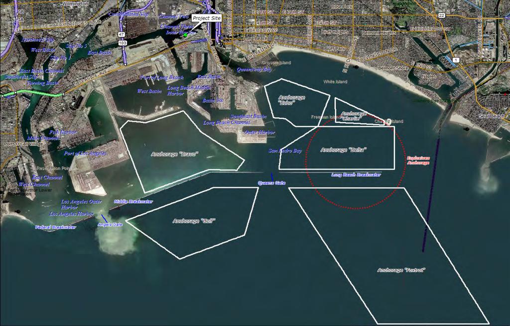
1 3.6 VESSEL TRANSPORTATION The vessel transportation analysis assesses the waters serving Channels 2 and 3, the POLB, and San Pedro Bay. Given the proximity of the Project to the POLA, the vessel transportation analysis includes the combined shipping, vessel transportation movement, vessel movement controls and safety features, and accident potential for both ports Environmental Setting Most commercial ship traffic generally approaches the POLB from the northwest, passing north of Catalina Island. Traffic coming from the south passes east of the island. Both approaches, as illustrated in Figure 3.6-1, use established commercial shipping lanes. The POLB and POLA are protected by three breakwaters: the San Pedro Breakwater; Middle Breakwater; and, Long Beach Breakwater. The openings between these breakwaters, known as Queens Gate and Angel s Gate, provide entry to the POLB and POLA, respectively (Figure 3.6-2). Vessel Transportation Safety Vessel traffic levels are highly regulated by the United States Coast Guard (USCG) Captain of the Port (COTP) and the Marine Exchange of Southern California via the Vessel Traffic Service (VTS) to ensure the total number of vessels transiting the Port does not exceed the design capacity of the federal channel limits. Mariners are required to report their position prior to transiting through the Port to the COTP and the VTS. The VTS monitors the positions of all inbound and outbound vessels within the Precautionary Area and the approach corridor traffic lanes (Figure 3.6-1). In the event of scheduling conflicts and/or vessel occupancy within the Port is operating at capacity, vessels are required to anchor at the commercial anchorages in the Outer Harbor or at anchorages outside the breakwater until mariners receive COTP authorization to initiate transit into the Port (Figure 3.6-2). An anchorage is an area within or outside of a harbor that is suitable for temporarily anchoring vessels, sometimes for a fee. Several measures are in place to ensure the safety of vessel navigation in the harbor area. Restricted navigation areas and routes have been designated to ensure safe vessel navigation, and are regulated by various agencies and organizations. These are described below. Marine Exchange of Southern California The Marine Exchange is a non-profit organization affiliated with the Los Angeles Chamber of Commerce, and designated to enhance navigation safety in the Precautionary Area and harbor area of the San Pedro Bay ports. The organization is supported by subscriptions from Port-related organizations that recognize the need for such an organization and use its services. The Marine Exchange monitors vessel traffic within the Precautionary Area. The service consists of a coordinating office, specific reporting points, and very high frequency-frequency modulation (VHF-FM) radio communications used with participating vessels. Vessel traffic channels and numerous aids to navigation (i.e., operating rules and regulations) have been established in the Port. The Marine Exchange also operates Physical Oceanographic Real Time System (PORTS) (described below) as a service to those making operational decisions based on oceanographic and meteorological conditions in the vicinity of the Ports. The PORTS collects and disseminates accurate real time information on tides, visibility, winds, currents, and sea swell to maritime users to assist in the safe and efficient transit of vessels in the Port area. Vessel Transportation Service The VTS is a service owned by the Marine Exchange and operated jointly by the Marine Exchange and the USCG under the over-sight of the Office of Oil Spill Prevention and Response (OSPR) and the POLB/POLA Harbor Safety Committee. The VTS monitors traffic in the approach and departure lanes and inside the harbors. It uses radar, radio, and visual inputs to gather real time vessel traffic information and broadcast traffic advisories EAGLE ROCK AGGREGATE TERMINAL PROJECT APRIL 2013
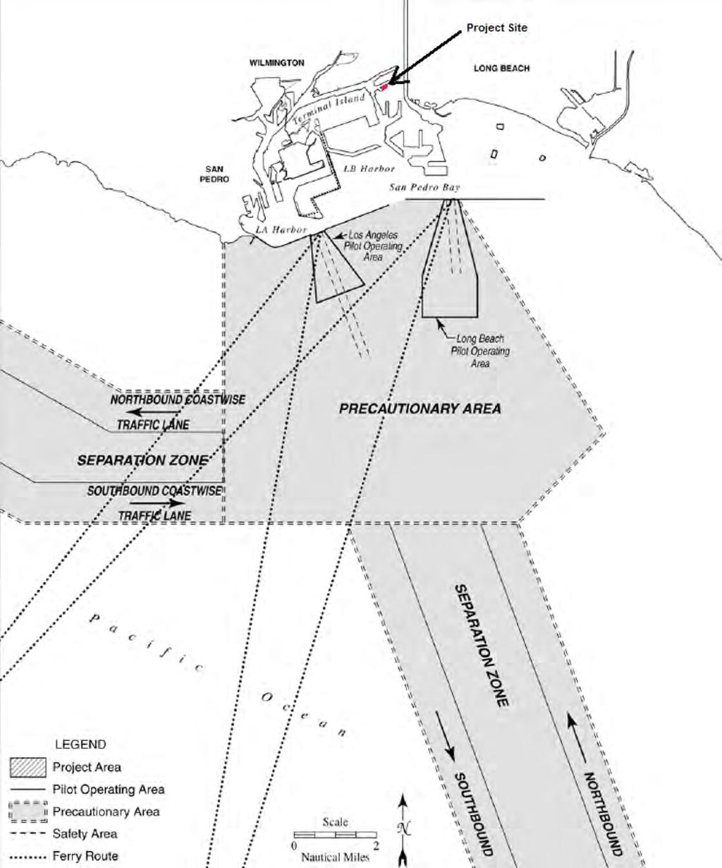
2
3
4 and summaries to assist mariners. The VTS that services POLB and POLA is located at the entrance of the ports. The system provides information on vessel traffic and ship locations so that vessels can avoid collisions, allisions, and groundings in the approaches to the Los Angeles/Long Beach Harbor. The VTS assists in the safe navigation of vessels approaching POLB and POLA in the Precautionary Area. Traffic Separation Schemes (TSS) A TSS is an internationally recognized vessel routing designation that separates opposing flows of vessel traffic into lanes, including a zone between lanes where traffic is to be avoided. TSSs have been designated to help direct offshore vessel traffic along portions of the California coastline such as the Santa Barbara Channel. Vessels are not required to use any designated TSS, but failure to use one, if available, would be a major factor for determining liability in the event of a collision. TSS designations are proposed by the USCG, but must be approved by the International Maritime Organization (IMO), which is part of the United Nations. Figure identifies the TSS nearest the POLB and POLA. Safety Fairways Offshore waters in high traffic areas are designated as safety fairways and are frequently located between a port and the entry to TSS. The USACE is prohibited from issuing permits for surface structures (e.g., oil platforms) within these safety fairways in order to ensure safer navigation. Precautionary and Regulated Navigation Areas A Precautionary Area is designated in congested areas near the POLB/POLA harbor entrances to set speed limits or to establish other safety precautions for ships entering or departing the Harbor. A regulated navigation area (RNA) is defined as a water area within a defined boundary for which federal regulations for vessels navigating within this area have been established under CFR 33 Part 165, Subsection In the case of the Los Angeles/Long Beach Harbor, RNA boundaries match the designated Precautionary Area. CFR 33, Part 165, Subsection , identifies portions of the Precautionary Area as RNA. The Precautionary Area for POLB/POLA is defined by a line that extends south from Point Fermin for approximately seven nautical miles, continues due east approximately seven nautical miles, continues northeast for approximately three nautical miles, and then heads back northwest (Figure 3.6-1). Ships are required to cruise at speeds of 12 knots or less upon entering the Precautionary Area. A minimum vessel separation of 0.25 nautical miles is also required in the Precautionary Area. The Marine Exchange of Southern California monitors vessel traffic within the Precautionary Area. Pilotage Use of a Port Pilot for transit in and out of the San Pedro Bay area and adjacent waterways is required for all vessels of foreign registry, and for those U.S. vessels enrolled as not having a federally licensed pilot on board. Some U.S.-flag vessels have a trained and licensed pilot onboard and those vessels are not required to take on a Port Pilot for navigating through the Port. Jacobsen Pilot Service and Los Angeles Harbor Pilots provide pilotage to the POLB and POLA, respectively. Port pilots receive special training that is instituted by the pilot companies and overseen by the Harbor Safety Committee (see description in the Harbor Safety Committee section below). For the POLB, pilots typically board the vessels at the Queen s Gate entrance, and then pilot the vessels to their destinations. Pilots normally leave the vessels after docking, and re-board the vessels to pilot them back to sea or to other destinations within the Ports. The pilot service also manages the use of anchorages under an agreement with the USCG. In instances where a local pilot is not used, masters must have a local federal pilot license and receive approval by the USCG COTP prior to entering or departing the Port. In addition, the Port Tariffs require vessels greater than 300 gross tons to use a federally EAGLE ROCK AGGREGATE TERMINAL PROJECT APRIL 2013
5 licensed pilot whenever navigating inside the breakwater. The Port Tariffs also require that vessels notify the affected pilot station(s) in the rare instances when a pilot is not needed before entering, leaving, shifting, or moving between the Ports. By Port Tariffs rule, pilots stay on outbound vessels until clear of the breakwater entrance. In bad weather, pilots who cannot disembark safely outside the breakwaters may disembark inside, once they ensure the vessel s safe transit. Tug Escort/Assist Tug Escort refers to the stationing of tugs in proximity of a vessel as it transits into port to provide immediate assistance should a steering or propulsion failure develop. Tug Assist refers to the positioning of tugs alongside a vessel and applying force to assist in making turns, reducing speed, providing propulsion, and docking. Most ocean-going vessels are required to have tug assistance within the POLB and POLA (Harbor Safety Committee, 2004). However, some vessels have internal tugs (typically bow and stern thrusters) that allow the vessel to propel without engaging the main engines, which allows the vessel to accomplish maneuvers with the same precision as a tug-assisted vessel. These ships are not required to have external tug assistance. Physical Oceanographic Real Time System (PORTS) In partnership with the NOAA, National Ocean Service (NOS), California OSPR, United States Geological Survey (USGS), and some businesses operating in the ports, the Marine Exchange operates PORTS as a service to those making operational decisions based on oceanographic and meteorological conditions in the vicinity of the ports. PORTS is a system of environmental sensors and supporting telemetry equipment that gathers and disseminates accurate real time information on tides, visibility, winds, currents, and sea swell to maritime users to assist in the safe and efficient transit of vessels in the port area. Locally, PORTS is designed to provide crucial real-time information about POLA and POLB water levels, currents, salinity, and winds to mariners, oil spill response teams, managers of coastal resources, and others. The instruments that collect the information are deployed at strategic locations within the Ports to provide data at critical locations, and to allow now-casting and forecasting using a mathematical model of the Harbor s oceanographic processes. Data from the sensors are fed into a central collection point. These raw data are then integrated and synthesized into information and analysis products, including graphical displays of PORTS data. Navigational Hazards Port Pilots responsible for directing vessels through the POLB and POLA navigational water can easily identify fixed navigational hazards. These hazards, including breakwaters protecting the Outer Harbor, anchorage areas, and various wharfs and land masses, are well-lighted and are readily identified by radar. Four bridges cross the navigation channels of both ports. All have restricted vertical clearances, and two have restricted horizontal clearances as well. Within the POLB, overhead power lines also restrict vertical clearance in the Cerritos Channel. Two fixed bridges (Vincent Thomas and Gerald Desmond) and two drawbridges (Commodore Schuyler F. Heim highway bridge and adjacent Ford Avenue railroad bridge) span the navigable channels of the ports. The latter two, crossing Cerritos Channel, are the only drawbridges within the Port's geographical area. The narrow channelwidth combined with restrictions on passing under the drawbridges limit traffic through Cerritos Channel (with extremely rare exceptions) to pleasure vessels, tugs without tows and tugs with tows alongside or pushing ahead. However, tugs with bunker barges frequently pass under the bridges. Small size tankers occasionally pass, given appropriate weather, vessel draft and trim and maximum beam (Harbor Safety Committee, 2011). Project-related vessels would generally be unaffected by bridge limitations within the Port. In addition, the Commodore Heim lift bridge is currently being replaced (by Caltrans) with a fixed bridge with an under clearance of 47 feet. EAGLE ROCK AGGREGATE TERMINAL PROJECT APRIL 2013
6 Vessels waiting to enter the Port and moor at a berth, can anchor at the commercial anchorages outside and inside the breakwaters (Figure 3.6-2). Vessels do not require tug assistance to anchor outside the breakwater. Currently POLB has the following anchorages available inside the breakwater: 12 in the Bravo area; two in the Charlie area; 9 in the Delta area; and five in the Echo area. Jacobsen Pilot Service (JPS) manages and monitors these anchorages for the POLB. For safety reasons, VTS will not assign an anchorage in the first row of sites closest to the breakwater to tankers or vessels exceeding 656 feet in length. Vessels are required by law to report failures of navigational equipment, propulsion, steering, or other vital systems as soon as possible to the USCG via the COTP office or the COTP representative at VTS. According to VTS, approximately one in 100 vessels calling at POLB/POLA experiences a mechanical failure during its inbound or outbound transit. Although marine safety is thoroughly regulated and managed, various undesirable events can occur during marine navigation. These conditions include vessel accidents, close quarters, and near misses. Brief descriptions of these events are given below. The most significant historical incidents in the POLB/POLA areas include a potentially disastrous collision between two loaded tankers in 1981, and close calls such as a 1982 occurrence involving two passenger ships, a freighter, and a tanker. Vessel Accidents TABLE ALLISIONS, COLLISIONS, AND GROUNDINGS POLB/POLA ( ) Marine vessel accidents include vessel collisions (between two moving vessels), allisions (between a moving vessel and a stationary object, including another vessel), and vessel groundings. Table shows the number of vessel allisions, collisions, and groundings (ACGs) in the POLB and POLA between 1997 and Between 1992 and 1998, there were on average, four ACG incidents per year (U.S. Naval Academy, 1999). During 1992 and 1998, the level of commercial traffic transits has remained fairly constant. There are no reliable, comparable data available on the number of recreational boating incidents in the ports. Year Allisions Collisions Groundings Total Note: These commercial vessel accidents meet the reportable level defined in 46 CFR 4.05, but do not include commercial fishing vessel or recreational boating incidents. Source: Harbor Safety Committee, EAGLE ROCK AGGREGATE TERMINAL PROJECT APRIL 2013
7 Each of the accidents referenced above was subject to a USCG marine casualty investigation, and the subsequent actions taken were targeted at preventing future occurrences. Ships are typically involved in about 11 percent of all marine accidents, or only 7.7 percent of ACG incidents (U.S. Naval Academy, 1999).The largest number of accidents involved tug boats and barges. Table lists accident rates reported by different studies. TABLE VESSEL ACCIDENT RATES Study/Source Years, Range Ships/Conditions Involved Type of Accident Probability per Transit MIT All ships All accidents % USCG All US ports, deep draft only ACGs 0.20% USCG Ships only At sea collisions 0.013% USCG Ships only At sea groundings 0.010% USCG Ships only At sea allisions % USCG Ships only Total All ACGs 0.031% FEMA In harbors/bays Collisions and groundings FEMA In harbors/bays Collisions while moored 0.10% 0.02% POLA/POLB In POLA/POLB Total All ACGs 0.046% Note: These commercial vessel accidents meet a reportable level defined in 46 CFR 4.05, but do not include commercial fishing vessel or recreational boating casualties. Sources: MIT, 1998; U.S. Naval Academy, 1999; FEMA, 1989; Harbor Safety Committee According to the USCG vessel accidents database, the POLB/POLA harbor area has one of the lowest accident rates among all U.S. ports, with the ACGs frequency of 3.8 x 10⁻⁵ per transit ( percent chance per transit), compared to the average of 2.54 x 10⁻⁴ per transit (0.025 percent chance per transit) for all U.S. ports. The calculated ACG frequency for the period 1997 through 2010 is somewhat higher at 4.4 x 10⁻⁴ per transit, although the 2010 ACG rate was substantially lower at 1.0 x 10⁻⁴ per transit. Near Misses and Close Quarters. According to the POLB/POLA Harbor Safety Committee, a near miss is defined as: A reportable near miss is an incident in which a pilot, master or other person in charge of navigating a vessel successfully takes action of a non-routine nature to avoid a collision with another vessel, structure, or aid to navigation, grounding of the vessel, or damage to the environment. The most practical and readily available nearmiss data are obtained from VTS reports. The VTS documents, reports, and takes action on close quarters situations. These situations are described as vessels passing an object or another vessel closer than 0.25 nautical miles or 500 yards. These incidents usually occur within the traffic Precautionary Area. No reliable data are available for close quarters incidents outside the VTS area. Normal actions taken in response to close quarters situations include: initiating informal USCG investigation, sending Letters of EAGLE ROCK AGGREGATE TERMINAL PROJECT APRIL 2013
8 Concern to owners and/or operators, having the involved vessel Master(s) visit VTS and review the incident, and USCG enforcement boardings. An eleven-year history of the number of close quarters situations is presented in Table The Harbor Safety committee states that given the relatively steady amount of commercial transits over the past five years, a decreasing trend in close quarters incidents is discernible (Harbor Safety Committee, 2011).. TABLE NUMBER OF VTS-RECORDED CLOSE QUARTERS INCIDENTS ( ) No. of Close Year Quarters Source: Harbor Safety Committee, Factors Affecting Vessel Traffic Safety This section summarizes environmental conditions that could impact vessel safety in the POLB/POLA area. More detailed information can be found in the existing conditions description of other POLB/POLA EIS/EIRs. Fog Fog is a well-known weather condition in southern California. Harbor area fog occurs most frequently in April and from September through January, when visibility over the bay is below 0.5 mile for seven to 10 days per month. Fog at the ports is mostly a land (radiation) type fog that drifts offshore and worsens in the late night and early morning. Smoke from nearby industrial areas often adds to its thickness and persistence. Along the shore, fog drops visibility to less than 0.5 mile on three to eight days per month from August through April, and is generally at its worst in December (Harbor Safety Committee, 2011). Winds Winds vary, particularly in fall and winter. They are strongest during this period when the Santa Anas may blow. This offshore desert wind, though infrequent, may be violent. It occurs when a strong high-pressure system sits over the plateau region and generates a Northeasterly to Easterly flow over Southern California. Aside from weather forecasts, there is little warning of a Santa Ana s onset, although good visibility and unusually low humidity often prevail for some hours before it arrives. Shortly before arriving on the coast, the Santa Ana may appear as an approaching dark-brown dust cloud. This positive indication often gives a 10 to 30 minute warning. The Santa Ana may come at any time of day and can be reinforced by an early morning land breeze or weakened by an afternoon sea breeze. Winter storms produce strong winds over San Pedro Bay, particularly from southwesterly through northwesterly. Winds of 17 knots or greater occur about 1 to 2 percent of the time from November through May. Southwesterly through westerly winds begin to prevail in the spring and last into early fall. Tides The mean range of tide is 3.7 feet for the POLB and 3.8 feet for the POLA. The diurnal range is about 5.4 feet for both harbors and a range of nine feet may occur at maximum tide. The time of tide is about the same for both harbors (Harbor Safety Committee, 2011). Currents The tidal currents follow the axis of the channels and rarely exceed one knot. The POLB/POLA Harbor area is subject to seiche and surge, with the most persistent and conspicuous oscillation having about a onehour period. Near Reservation Point, the prominent hourly surge causes velocity variations as great as one knot. These variations often overcome the lesser tidal current, so that the current ebbs and flows at EAGLE ROCK AGGREGATE TERMINAL PROJECT APRIL 2013
9 half-hour intervals. The more restricted channel usually causes the surge through the Back Channel to reach a greater velocity at the east end of Terminal Island, rather than west of Reservation Point. In the Back Channel, hourly variation may be 1.5 knots or more. At times the hourly surge, together with shorter, irregular oscillations, causes a very rapid change in water height and current direction/ velocity, which may endanger vessels moored at the piers (Harbor Safety Committee, 2011). USACE ship navigation studies indicate that within the POLB channels, current magnitudes are essentially a negligible 1/3 knot or less. Maximum current velocity in the Angel s Gate area is less than one knot. These current magnitudes, determined during a simulation study, indicate depth-averaged values over three layers. According to Jacobsen Pilot Service, the Long Beach Queen s Gate has deeper water than Angel s Gate and more open waterways just inside the breakwater. The pilots have never experienced a current greater than one knot in this area (Harbor Safety Committee, 2011). Water Depths The USACE maintains the Federal Channels in the POLB and POLA. All 77 deep-water berths in the POLB lie within three miles of the open sea and are reached via a 76-foot deep Main Channel. The Main Channel lets tankers up to 310,000-ton class (current maximum draft 64 feet) discharge their cargos. Dredging outside the Long Beach breakwater Entrance Channel has also provided a 76-foot depth. POLB will continue to dredge throughout the Harbor District to maintain berth and channel depths. Periodic maintenance dredging maintains design depth and eliminates minor hazards caused by soil deposition or vessel propeller wash anomalies occurring on the bottom. Vessel Traffic Current Traffic Levels In 2010, the POLB experienced 5,512 ship calls, which included 2,212 inward and 2,189 outward ship movements, as well as an additional 1,111 internal movements where vessels shift berth or location within the Port. Between eight and 39 ship movements per day can occur within the Port, with an average of 20 ship movements per day. The majority of ship movements to and from the berths are completed in two hours or less and very few movements are greater than three hours in duration. The present level of ship movements has been sustained over the previous five years. The pilot service and tug assistance can routinely handle up to 25 ship movements per day and can handle peaks of 30 to 40 ship movements per day. Future Traffic Levels The demand for POLB containerized cargo capacity is expected to increase to up to 7,600 ship calls in This would result in between 10,400 and 15,200 inward and outward ship movements in 2020, which would translate to one ship movement every 50 minutes (low estimate) or every 35 minutes (high estimate). The ability of the POLB to handle increasing numbers of ships associated with various trades depends on primary and secondary factors that can limit vessel traffic. Primary factors are those features of the Port that cannot be changed, or can be changed or modified only with very high capital expenditure, including the breakwater entrance, channel depth, channel geometry, and/or environmental conditions. Of the primary factors, the breakwater entrance is wide enough to accept two-way traffic and is unlikely to be a constraint on capacity. The water depth in the Outer Harbor is about 70 feet and in the inner basins is about 40 to 60 feet. Secondary factors are those features of the Port that can be changed or modified at modest capital or operational expenditure, including pilotage and towage services Regulatory Setting Many laws and regulations are in place to regulate marine terminals, vessels calling at marine terminals, and emergency response/ contingency planning. Responsibilities for enforcing or executing these laws and EAGLE ROCK AGGREGATE TERMINAL PROJECT APRIL 2013
10 regulations fall to various international, federal, state, and local agencies, as summarized below. Federal Laws A number of federal laws regulate marine terminals and vessels. These laws address, among other matters, design and construction standards, operational standards, and spill prevention and cleanup. Regulations to implement these laws are contained primarily in Titles 33 (Navigation and Navigable Waters), 40 (Protection of Environment), and 46 (Shipping) of the CFR. More detailed information on the safety of life and protection of property and the environment during marine transportation of hazardous materials is summarized in EIS/EIR Section 3.10 (Hazards and Hazardous Materials). United States Coast Guard The USCG, through Title 33 (Navigation and Navigable Waters) and Title 46 (Shipping) of the CFR, is the federal agency responsible for vessel inspection, marine terminal operations safety, coordination of federal responses to marine emergencies, enforcement of marine pollution statutes, marine safety (navigation aids, etc.), and operation of the NRC for spill response. They are also the lead agency for offshore spill response. More detailed information on safety and safe navigation responsibilities of USCG are summarized in EIS/EIR Section 3.10 (Hazards and Hazardous Materials). The Department of Defense (DoD) The DoD, through the USACE, is responsible for reviewing all aspects of a project and/or spill response activities that could affect navigation. The USACE has specialized equipment and personnel for maintaining navigation channels, removing navigation obstructions, and accomplishing structural repairs. Since 1789, the federal government has authorized navigation channel improvement projects. The General Survey Act of 1824 established the USACE's role as the agency responsible for the navigation system. Since then, ports have worked in partnership with the USACE to maintain waterside access to port facilities. State and Local Organizations and Programs Marine Exchange of Southern California As discussed previously, the Marine Exchange is a non-profit organization affiliated with the Los Angeles Chamber of Commerce. This voluntary service is designated to enhance navigation safety in the Precautionary Area and harbor area of the Ports. The Marine Exchange monitors vessel traffic within the Precautionary Area. The Marine Exchange also operates PORTS (described previously) as a service to those making operational decisions based on oceanographic and meteorological conditions in the vicinity of the ports. Harbor Safety Committee The POLB and POLA have a Harbor Safety Committee (Committee), which is responsible for planning the safe navigation and operation of tankers, barges, and other vessels within San Pedro Bay and the approaches thereto. This Committee was created under the authority of Government Code Section (a), which requires the Administrator of the Office of OSPR to create a Harbor Safety Committee for the Long Beach/Los Angeles/Harbor area. The Committee issued the original Harbor Safety Plan (HSP) in 1991, and has issued annual updates since that time. Major issues facing the Committee include questions regarding the need for escort tugs, required capabilities of escort tugs, and/or need for new or enhanced vessel traffic information systems to monitor and advise vessel traffic. Harbor Safety Plan (HSP) The POLB/POLA HSP contains operating procedures for vessels operating in the port vicinity. The vessel operating procedures stipulated in the HSP are considered Good Marine Practice. Some procedures are federal, State, or local regulations, while other guidelines are non-regulatory Standards of Care. The HSP provides specific rules for navigation of vessels in EAGLE ROCK AGGREGATE TERMINAL PROJECT APRIL 2013
11 reduced visibility conditions, and establishes vessel speed limits (12 knots within the Precautionary Area or six knots within the harbor). These speed restrictions do not preclude the master or pilot from adjusting speeds to avoid or mitigate unsafe conditions. Vessel Transportation Service As described previously, VTS is a shipping service that monitors traffic in both approach and departure lanes, as well as internal movement within harbor areas. This system provides information on vessel traffic and ship locations so that vessels can avoid collisions, allisions, and groundings in the approaches to the Long Beach/Los Angeles Harbor. These services use radar, radio, and visual inputs to gather real time vessel traffic information and broadcast traffic advisories and summaries to assist mariners Significance Criteria The State CEQA Guidelines do not provide significance thresholds specifically related to vessel transportation. To evaluate Project impacts related to vessel traffic, the POLB has adapted the aircraft safety threshold contained in the State CEQA Guidelines Appendix G (Environmental Checklist) to apply to vessel transportation. Accordingly, a significant impact on marine vessel transportation would occur if the Project would: VT-1: Result in a change in vessel traffic patterns, including an increase in traffic volumes or a change in location that results in substantial incremental change in risks to vessel safety. Potential impacts associated with this criterion have been assessed for both Project construction (Impact VT-1) and Project operation (Impact VT-2) Assessment Methodology The following analysis considers the specific type and number of vessels that currently visit the POLB and pass by the Project area and its alternatives, and evaluates the number and characteristics of vessels that would be calling at the redeveloped facilities after Project implementation. Specific design features of the Project and the historical accident record for similar terminals at other ports are evaluated. Information regarding potential hazards during vessel approaches and departure is evaluated based on historical data, interviews with Port personnel, and information available from the Harbor Safety Committee and Port Pilots. In addition, available statistical data on accidents that involve marine vessels (Table 3.6-2) have been used to estimate potential Project-related increases in ACGs. The data, including standard deviations, are included to provide a perspective to the natural variability of ACGs at the Port Impacts and Mitigation Measures Alternative 1 Proposed Project Aggregate material would be delivered to the Project site via Panamax-class vessels originating from two quarry locations in British Columbia, Canada. These vessels are an estimated 804 feet in length with a beam of 105 feet, a draft of 44 feet, and a deadweight capacity of up to 80,000 short tons. It is currently anticipated that operation of the Proposed Project would begin in early 2013 and reach its full throughput capacity of 2.75 million tons per year by NEPA Impacts Construction Impacts Impact VT-1: Project construction-related marine traffic would not interfere with normal navigational activities within and near the POLB. Proposed Project dredging activities would occur on a single day during the first month of construction and would require a crew of three to four workers operating one diesel powered clam-shell dredge, one barge and a tugboat. Under one dredge disposal option, the dredge material disposal would entail one vessel trip between Berth D-44 and the Middle Harbor Slip No.1 Fill Site (see Figure 1.6-2). Activities associated with this option would be strictly scheduled by the POLB to minimize potential conflicts with container vessel traffic. Any support boat or barge used during construction-related activities would generally be located in areas away from EAGLE ROCK AGGREGATE TERMINAL PROJECT APRIL 2013
12 normal navigational activities and would not represent new navigational hazards. Therefore, the presence of these vessels within the Inner Harbor area during the one day dredging period would not substantially reduce the existing level of safety for vessel navigation in the POLB. The Project would also be subject to the USACE restrictions and requirements, and would be required to coordinate with the Marine Exchange and USCG. Additionally, all in-water construction activities would be transmitted over Channel 16, which is monitored by all vessels in the Port. The other dredge disposal option would be done on land by truck and would not have the potential to interfere with any navigational activities. As all in-water construction vessel traffic would be subject to established regulatory conditions ensuring safety of users in Long Beach Harbor waters, and activities would be scheduled to avoid existing marine container terminal traffic, impacts on vessel traffic would be less than significant. Under the second option the dredged material would be transported to the Middle Harbor Slip No.1 Fill Site by truck and no vessel traffic impacts would occur. Operational Impacts Impact VT-2: Project operations would not result in a substantial increase in vessel traffic or a change in patterns of vessel movements that would impair the level of safety for vessels navigating in the Inner Harbor area and/or the precautionary areas. The Project would decrease the total number of vessels calling at the Inner Harbor bulk terminal by 185 vessels per year, an approximately 3.8 percent decrease from the NEPA Baseline of annual POLB vessel calls. All vessel traffic at the Project site would be coordinated consistent with the Channel 3 Traffic Procedures, which require advanced notification of ship arrival and ship movement coordination with other Channel 3 operators. The available statistical data on accidents that involve marine vessels (Table 3.6-2) can be used to estimate potential Project-related increases in ACGs. Table provides an overview of the expected number of ACGs that could occur during open ocean transit and within the POLB as a result of the proposed Project. The average number of ACGs within the POLB/POLA over the period 1997 through 2010 is 6.6, with a standard deviation of 3.3 that represents the inter-annual variability. The projected Project-related decrease of ACGs per year would be substantially less than the historical standard deviation of 3.3 ACGs per year. The total annual Projectrelated ACGs would decrease the overall annual average accident rate by approximately 2.5 percent. As the estimated number of Project-related vessel accidents would decrease the overall annual average accident rate within the POLB and POLA by 2.5 percent, Project impacts on vessel transportation safety would be less than significant under NEPA. Mitigation Measures Under the Proposed Project impacts on vessel transportation would be less than significant; as such, no mitigation is required. Significance of Impacts after Mitigation Under NEPA, impacts on vessel transportation due to construction and operation of Alternative 1 would be less than significant. CEQA Impacts Construction Impacts Impact VT-1: Project construction-related marine traffic would not interfere with normal navigational activities within and near the POLB. Proposed Project dredging activities would occur on a single day during the first month of construction and would require a crew of three to four workers operating one diesel powered clam-shell dredge, one barge and a tugboat. Under one Project option, dredge material disposal would entail one vessel trip between Berth D-44 and the Middle Harbor Slip No. 1 Fill Site (see Figure 1.6-2). These activities would be strictly scheduled by the POLB to minimize potential conflicts with container vessel traffic. Any support boat or barge used during construction-related activities would generally be located in areas away from normal navigational activities and would not represent new navigational hazards. EAGLE ROCK AGGREGATE TERMINAL PROJECT APRIL 2013
13 TABLE PROBABILITIES OF POTENTIAL ALLISIONS, COLLISIONS, AND GROUNDINGS. Scenario Probability Per Transit 1 Annual Project NEPA Probability 2 Annual Project CEQA Probability 3 Open Ocean Transit Within the POLB Notes: 1 - This probability is the chance of a vessel experiencing the listed event during a single transit. 2 - This probability is the chance of the expected 35 additional Project-related vessels experiencing the listed event during a single year of transits versus a NEPA Baseline of 220 vessels (see Alternative 3). The reduction of vessel calls to 35 from the 220 under the NEPA Baseline would result in a net decrease in the probability of a vessel accident. 3 - This probability is the chance of the expected 35 additional Project-related vessels experiencing the listed event during a single year of transits. Source: USCG, 2003; FEMA, 1989; Harbor Safety Committee, Therefore, the presence of these vessels within the Inner Harbor area during the oneday dredging period would not substantially reduce the existing level of safety for vessel navigation in the POLB. The Project would also be subject to the USACE restrictions and requirements, and would be required to coordinate with the Marine Exchange and USCG. Additionally, all in-water construction activities would be transmitted over Channel 16, which is monitored by all vessels in the Port. The other disposal option would involve the transport of the dredge material to the Middle Harbor Slip No. 1 Fill Site by truck, which would not affect any navigational activities. As all in-water construction vessel traffic would be subject to established regulatory conditions and activities would be scheduled to avoid existing marine container terminal traffic, impacts on vessel traffic would be less than significant. Under the second option for the disposal of dredged material, trucks would be used instead of barges. Consequently, under this option there would be no impacts to vessel traffic. Operational Impacts Impact VT-2: Project operations would not result in a substantial increase in vessel traffic or a change in patterns of vessel movements that would impair the level of safety for vessels navigating in the Inner Harbor area and/or the precautionary areas. The Project would increase the total number of vessels calling at the Inner Harbor bulk terminal by 35 vessels per year, an approximately 0.7 percent increase over the current number of annual POLB vessel calls. All vessel traffic at the Project site would be coordinated consistent with the Channel 3 Traffic Procedures, which require advanced notification of ship arrival and ship movement coordination with other Channel 3 operators. The available statistical data on accidents that involve marine vessels (Table 3.6-2) can be used to estimate potential Project-related increases in ACGs. Table provides an overview of the expected number of ACGs that could occur during open ocean transit and within the POLB as a result of the proposed Project. The average number of ACGs within the POLB/POLA over the period 1997 through 2010 is 6.6, with a standard deviation of 3.3 that represents the inter-annual variability. The projected Project-related increase of 0.03 ACGs per year would be substantially less than the historical standard deviation of 3.3 ACGs per year. The total annual Projectrelated ACGs would increase the overall annual average accident rate by approximately 0.5 percent. As the estimated number of Project-related vessel accidents would increase the overall annual average accident rate within the POLB and POLA by only 0.5 percent, Project impacts on vessel transportation safety would be less than significant under CEQA. EAGLE ROCK AGGREGATE TERMINAL PROJECT APRIL 2013
14 Mitigation Measures Under the Proposed Project impacts on vessel transportation would be less than significant; as such, no mitigation is required. Significance of Impacts after Mitigation Under CEQA, impacts on vessel transportation due to construction and operation of Alternative 1 would be less than significant Alternative 2 Pier B Street Alternative Under the Pier B Street Alternative, vessels would access the site from the Back Channel/Cerritos Channel Turning Basin and enter Channel 2 from the west. Channel 2 is approximately 0.75 mile (3,978 feet) in length and an estimated 535 feet in width at Berths B82-B83. Existing water depths of Channel 2 can accommodate Panamax-class vessels; consequently no dredging during construction would be required. Operation of the Pier B Street Alternative would be identical to that of the Proposed Project, as detailed in Section , except that due to this alternative's 21-month construction period, the maximum annual throughput of 2.75 million tons of aggregate material would not occur until In addition, Pier B would be a shared berth. As such, Eagle Rock would be last on the list and may be required to remove their vessel from the berth for operations related to Toyota, Petro Diamond, National etc., and wait their turn before going back to the berth to finish unloading aggregate. NEPA Impacts Construction Impacts Impact VT-1: Project construction-related marine traffic would not interfere with normal navigational activities within and near the POLB. Construction of this alternative would occur in two phases. However, construction would not involve any activities that could impact marine vessel operations in the Port. Therefore, there would not be any impact to marine transportation as a result of constructionrelated activities. Operational Impacts Impact VT-2: Project operations would not result in a substantial increase in vessel traffic or a change in patterns of vessel movements that would impair the level of safety for vessels navigating in the Inner Harbor area and/or the precautionary areas. This alternative would decrease the total number of vessels calling at the Inner Harbor bulk terminal by 185 vessels per year, an approximately 3.8 percent decrease from the NEPA Baseline of annual POLB vessel calls. All vessel traffic at the project site would be coordinated consistent with the Channel Two Traffic Procedures. The available statistical data on accidents that involve marine vessels (Table 3.6-2) can be used to estimate potential Project-related increases in ACGs. Table provides an overview of the expected number of ACGs that could occur during open ocean transit and within the POLB as a result of the proposed Project. The average number of ACGs within the POLB/POLA over the period is 6.6, with a standard deviation of 3.3 that represents the inter-annual variability. The projected alternative-related decrease of ACGs per year would be substantially less than the historical standard deviation of 3.3 ACGs per year. The total annual Projectrelated ACGs would decrease the overall annual average accident rate by approximately 2.5 percent. As the estimated number of Project-related vessel accidents would decrease the overall annual average accident rate within the POLB and POLA by only 2.5 percent, Project impacts on vessel transportation safety would be less than significant under NEPA. EAGLE ROCK AGGREGATE TERMINAL PROJECT APRIL 2013
15 TABLE PROBABILITIES OF POTENTIAL ALLISIONS, COLLISIONS, AND GROUNDINGS. Scenario Probability Per Transit 1 Annual Project NEPA Probability 2 Annual Project CEQA Probability 3 Open Ocean Transit Within the POLB Notes: 1 - This probability is the chance of a vessel experiencing the listed event during a single transit. 2 - This probability is the chance of the expected 35 additional Project-related vessels experiencing the listed event during a single year of transits versus a NEPA Baseline of 220 vessels (see Alternative 3). The reduction of vessel calls to 35 from the 220 under the NEPA Baseline would result in a net decrease in the probability of a vessel accident. 3 - This probability is the chance of the expected 35 additional Project-related vessels experiencing the listed event during a single year of transits. Source: USCG, 2003; FEMA, 1989; Harbor Safety Committee, Mitigation Measures As impacts on vessel transportation would be less than significant, no mitigation is required. Significance of Impacts after Mitigation Under NEPA, the impacts on vessel traffic due to implementation of the Pier B Street Alternative would be less than significant. CEQA Impacts Construction Impacts Impact VT-1: Project construction-related marine traffic would not interfere with normal navigational activities within and near the POLB. Construction of this alternative would occur in two phases. However, construction would not involve any activities that could impact marine vessel operations in the Port. Therefore, there would not be any impact to marine transportation as a result of constructionrelated activities. Operational Impacts Impact VT-2: Project operations would not result in a substantial increase in vessel traffic or a change in patterns of vessel movements that would impair the level of safety for vessels navigating in the Inner Harbor area and/or the precautionary areas. This alternative would increase the total number of vessels calling at the Inner Harbor bulk terminal by 35 vessels per year, an approximately 0.7 percent increase over the current number of annual POLB vessel calls. All vessel traffic at the project site would be coordinated consistent with the Channel Two Traffic Procedures. The available statistical data on accidents that involve marine vessels (Table 3.6-2) can be used to estimate potential Project-related increases in ACGs. Table provides an overview of the expected number of ACGs that could occur during open ocean transit and within the POLB as a result of the proposed Project. The average number of ACGs within the POLB/POLA over the period is 6.6, with a standard deviation of 3.3 that represents the inter-annual variability. The projected alternative-related increase of 0.03 ACGs per year would be substantially less than the historical standard deviation of 3.3 ACGs per year. The total annual Projectrelated ACGs would increase the overall annual average accident rate by approximately 0.5 percent. As the estimated number of Project-related vessel accidents would increase the overall annual average accident rate within the POLB and POLA by only 0.5 percent, Project impacts on vessel transportation safety would be less than significant. Mitigation Measures As impacts on vessel transportation would be less than significant, no mitigation is required. Significance of Impacts after Mitigation Under CEQA, the impacts on vessel traffic due to implementation of the Pier B Street Alternative would be less than significant. EAGLE ROCK AGGREGATE TERMINAL PROJECT APRIL 2013
16 Alternative 3 No Federal Action Alternative The NFA Alternative (Alternative 3) would be located at 1925 Pier D Street, the same site as the Proposed Project. However, under this alternative there would be no dredging within Channel 3 or wharf improvements to Berth D-44. Aggregate materials would be barged from the same two quarry locations in British Columbia, Canada, and unloaded to the stockpile areas via conveyor systems. As with the Proposed Project, operation of Alternative 3 would have a maximum annual throughput capacity of 2.75 million tons of aggregate. The barges would be towed by two dieselpowered tugboats from British Columbia and would utilize assist tugboats as necessary. The barge size would range between approximately 400 to 460 feet in length and 20 to 70 feet in width, with a maximum holding capacity of 12,500 tons of aggregate per load. At a maximum throughput capacity of 2.75 million tons of material per year, this alternative would require up to 220 barge trips annually, or an average of four to five barges per week. NEPA Impacts Construction Impacts Impact VT-1: Project construction-related marine traffic would not interfere with normal navigational activities within and near the POLB. The NFA Alternative is equivalent to the NEPA Baseline because it only includes construction activities that would not require issuance of federal permits. As no federal action or permit would be required, there would be no significance determination under NEPA for this alternative. Operational Impacts Impact VT-2: Project operations would not result in a substantial increase in vessel traffic or a change in patterns of vessel movements that would impair the level of safety for vessels navigating in the Inner Harbor area and/or the precautionary areas. Alternative 3 is equivalent to the NEPA Baseline because it only includes operational activities that would not require issuance of federal permits. As no federal action or permit would be required, there would be no significance determination under NEPA for this alternative. CEQA Impacts Construction Impacts Impact VT-1: Project construction-related marine traffic would not interfere with normal navigational activities within and near the POLB. Construction of this alternative would occur in two phases. However, construction would not involve any activities that could impact marine vessel operations in the Port. Therefore, there would not be any impact to marine transportation as a result of construction activities. Operational Impacts Impact VT-2: Project operations would not result in a substantial increase in vessel traffic or a change in patterns of vessel movements that would impair the level of safety for vessels navigating in the Inner Harbor area and/or the precautionary areas. This alternative would increase the total number of vessels calling at the Inner Harbor bulk terminal by 220 barges per year, an approximately 4.5 percent increase over the current number of annual POLB vessel calls. All vessel traffic at the project site would be coordinated consistent with the Channel 3 Traffic Procedures. The available statistical data on accidents that involve marine vessels (Table 3.6-2) can be used to estimate potential alternative-related increases in ACGs. Table provides an overview of the expected number of ACGs that could occur during open ocean transit and within the POLB as a result of the Project. The average number of ACGs within the POLB/POLA over the period is 6.6, with a standard deviation of 3.3 that represents the inter-annual variability. The projected alternative-related increase of 0.2 ACGs per year would be substantially less than the historical standard deviation of 3.3 ACGs per year. The total annual Project-related ACGs would increase the overall annual average accident rate by approximately 3 percent. EAGLE ROCK AGGREGATE TERMINAL PROJECT APRIL 2013
3.7 VESSEL TRANSPORTATION Environmental Setting Area of Influence Setting. Vessel Transportation Service
 3.7.1 Environmental Setting 3.7.1.1 Area of Influence The vessel transportation analysis covers the waters serving POLB, and the San Pedro Bay, which is shared with POLA. This analysis considers the shipping
3.7 VESSEL TRANSPORTATION Environmental Setting Area of Influence Setting
 3.7 VESSEL TRANSPORTATION 3.7.1 Environmental Setting 3.7.1.1 Area of Influence The vessel transportation analysis covers the waters of San Pedro Bay, which includes the Pier S site. Given the proximity
3.9 Marine Transportation
 3.9 Marine Transportation 3. Affected Environment and Environmental Analysis 3.9 Marine Transportation 3.9.1 Introduction This section describes existing marine vessel transportation within the Port, the
SECTION SUMMARY. Section 3.10 Marine Transportation
 Section.0 Marine Transportation 0 0 0 SECTION SUMMARY This section describes existing marine transportation within the Port and identifies potential impacts to marine transportation including navigation
Introduction Environmental Setting. Section 3.10 Marine Transportation Vessel Transportation Safety
 Section.0 Marine Transportation 0 0.0. Introduction This section describes existing marine transportation within the Port of Los Angeles (Port) and the West Basin and potential s on marine transportation
3.9 Marine Transportation
 3.9 Marine Transportation 3. Affected Environment and Environmental Analysis 3.9 Marine Transportation 3.9.1 Introduction This section describes existing marine vessel transportation within the Port, the
V. HARBOR DEPTHS, CHANNEL DESIGN AND PROPOSED CONSTRUCTION AND DREDGING
 V. HARBOR DEPTHS, CHANNEL DESIGN AND PROPOSED CONSTRUCTION AND DREDGING A. DISCUSSION: For the most part, projects that involve dredging and construction require a comprehensive design and review process
Chapter 19 TRANSPORTATION AND TRAFFIC (MARINE)
") Chapter 19 TRANSPORTATION AND TRAFFIC (MARINE) 19.1 Introduction This chapter describes existing conditions and applicable regulations related to marine transportation surrounding the Port of Los Angeles,
Chapter 19 TRANSPORTATION AND TRAFFIC (MARINE) 19.1 Introduction This chapter describes existing conditions and applicable regulations related to marine transportation surrounding the Port of Los Angeles,
The LA/LB Harbors handle more than 5,500 commercial vessel arrivals per year (excluding local coastwise and Catalina Island traffic).
.") X. SMALL CRAFT For the purpose of the Los Angeles and Long Beach Harbor Safety Plan, pleasure vessels, commercial fishing vessels and sportfishing boats are designated as small craft. A. BACKGROUND: The
X. SMALL CRAFT For the purpose of the Los Angeles and Long Beach Harbor Safety Plan, pleasure vessels, commercial fishing vessels and sportfishing boats are designated as small craft. A. BACKGROUND: The
World Shipping Council. Bureau of Ocean Energy Management Department of the Interior
 Comments of the World Shipping Council Submitted to the Bureau of Ocean Energy Management Department of the Interior In the matter of Commercial Leasing for Wind Power Development on the Outer Continental
MAC Transit Advisories as of April 30, 2018
 MAC Transit Advisories as of April 30, 2018 The Mariners Advisory Committee for the Bay and River Delaware was established in October 1964. Its members and associate members are mainly comprised of master
World Shipping Council. National Oceanographic and Atmospheric Administration
 Comments of the World Shipping Council Submitted to the National Oceanographic and Atmospheric Administration In the matter of Endangered and Threatened Species; Petition for Rulemaking to Establish a
WORK-REST REQUIREMENTS FOR PILOTS
 AN ORDER OF THE BOARD OF PILOT COMMISSIONERS FOR THE PORT OF CORPUS CHRISTI AUTHORITY REGARDING WORK-REST REQUIREMENTS FOR PILOTS AND COMBINED BEAM RESTRICTION Whereas, the current Rules and Regulations
Delaware River Vessel Reporting System Mariners Advisory Committee For
 Delaware River Vessel Reporting System Mariners Advisory Committee For the Bay and River Delaware The Mariner's Advisory Committee is comprised of Master Mariners, River Pilots, and concerns itself with
National Maritime Center
 National Maritime Center Providing Credentials to Mariners Q301 Rules of the Road-Inland (Sample Examination) Page 1 of 19 Choose the best answer to the following Multiple Choice Questions. NO reference
APC Operating Procedures Oil Tankers
 APC Operating Procedures Oil Tankers August 2013 The APC Operating Procedures were developed to aid the Master and Operator of oil tankers in ensuring all aspects of the APC are complied with when transiting
GENERAL LIMITATIONS AND RESTRICTIONS. LNGC Temporary Exemption (Effective August 21, 2018)
") RULES AND REGULATIONS GOVERNING PILOTS AND PILOTAGE ON THE CORPUS CHRISTI SHIP CHANNEL EFFECTIVE AUGUST 1, 2013 AMENDED EFFECTIVE MAY 13, 2014 AMENDED EFFECTIVE OCTOBER 1, 2014 AMENDED EFFECTIVE JANUARY
RULES AND REGULATIONS GOVERNING PILOTS AND PILOTAGE ON THE CORPUS CHRISTI SHIP CHANNEL EFFECTIVE AUGUST 1, 2013 AMENDED EFFECTIVE MAY 13, 2014 AMENDED EFFECTIVE OCTOBER 1, 2014 AMENDED EFFECTIVE JANUARY
AK-APC-NTV Operating Procedures for Cargo and Passenger Non Tank Vessels Transiting and Operating in Alaska Waters December 26, 2015
 AK-APC-NTV Operating Procedures for Cargo and Passenger Non Tank Vessels Transiting and Operating in Alaska Waters December 26, 2015 The Alternative Planning Criteria (APC) Operating Procedures were developed
Rules Practice Exam 7
 1 INTERNATIONAL ONLY The light which may be used with a vessel's whistle is to be. A. used when the whistle is broken B. used prior to sounding the whistle C. used only at night D. a white light 2 INTERNATIONAL
IMO RESOLUTION A.960(23) Adopted 5 December 2003 (Agenda item 17)
 Adopted 5 December 2003 (Agenda item 17)") INTERNATIONAL MARITIME ORGANIZATION E IMO ASSEMBLY 23rd session Agenda item 17 A 23/Res.960 5 March 2004 Original: ENGLISH RESOLUTION A.960(23) Adopted 5 December 2003 (Agenda item 17) RECOMMENDATIONS
INTERNATIONAL MARITIME ORGANIZATION E IMO ASSEMBLY 23rd session Agenda item 17 A 23/Res.960 5 March 2004 Original: ENGLISH RESOLUTION A.960(23) Adopted 5 December 2003 (Agenda item 17) RECOMMENDATIONS
GENERAL LIMITATIONS AND RESTRICTIONS. Draft Restrictions
 RULES AND REGULATIONS GOVERNING PILOTS AND PILOTAGE ON THE CORPUS CHRISTI SHIP CHANNEL EFFECTIVE AUGUST 1, 2013 AMENDED EFFECTIVE MAY 13, 2014 AMENDED EFFECTIVE OCTOBER 1, 2014 I GENERAL The Rules and
World Shipping Council. U.S. Coast Guard. Port Access Route Study: The Atlantic Coast From Maine to Florida
 Comments of the World Shipping Council Submitted to the U.S. Coast Guard In the matter of Port Access Route Study: The Atlantic Coast From Maine to Florida Docket Number: USCG-2011-0351 April 13, 2016
GUIDELINES FOR NAVIGATION UNDER THE CONFEDERATION BRIDGE
 (12/2009) GUIDELINES FOR NAVIGATION UNDER THE CONFEDERATION BRIDGE REVISION 1 DECEMBER 2009 Responsible Authority The Regional Director Marine Safety Atlantic Region is responsible for this document, including
Forth Ports Limited. Port of Dundee. Rig Move Guidelines
 Forth Ports Limited Port of Dundee Contents 1 Introduction... 4 2 Pre-Arrival... 4 2.1 Planning Meetings... 4 2.2 Priority of Movements... 4 2.3 Confirmation/Cancellations... 5 2.4 Weather Parameters...
Incident Management Guidelines for Initial Actions and Communications
 Lower Columbia Region Harbor Safety Committee Incident Management Guidelines for Initial Actions and Communications Page 1 of 16 Table of Contents A. INCIDENT MANAGEMENT GUIDELINES... 3 1. PURPOSE... 3
PILOTAGE DIRECTIONS REVIEWED DECEMBER 2016
 PILOTAGE DIRECTIONS REVIEWED DECEMBER 2016 REVISION LIST Revision No. Date Details Approved by: Original All sections 12 Dec 2013 First edition of C W Brand v1.0 Pilotage Directions Revision 2 all sections
World Shipping Council. Bureau of Ocean Energy Management
 Comments of the World Shipping Council Submitted to the Bureau of Ocean Energy Management In the matter of Potential Commercial Leasing for Wind Power on the Outer Continental Shelf (OCS) Offshore New
WAK-APC-T Operating Procedures for Oil Tankers Transiting or Operating in Western Alaska Waters
 WAK-APC-T Operating Procedures for Oil Tankers Transiting or Operating in Western Alaska Waters RECORD OF CHANGE WAK-APC-T Operating Procedures for Oil Tankers Transiting or Operating In Western Alaska
ASSOCIATED BRITISH PORTS - LOWESTOFT
 ASSOCIATED BRITISH PORTS - LOWESTOFT PILOTAGE DIRECTION (With Amendments To 01/02/2012) 1. AUTHORISATION Pilotage Act 1987. Associated British Ports Lowestoft (Pilotage) Harbour Revision Order 1988. 2.
Rules Practice Exam 11
 1 BOTH INTERNATIONAL & INLAND While underway in fog, you hear a vessel sound one prolonged blast followed by two short blasts on the whistle. What does this signal indicate? A. A vessel towing B. A vessel
GENERAL GUIDELINES FOR VESSELS TRANSITING RESTRICTED WATERWAYS OR PORTS
 GENERAL GUIDELINES FOR VESSELS TRANSITING RESTRICTED WATERWAYS OR PORTS Revised: March 5, 2018 TABLE OF CONTENTS GENERAL DEFINITIONS... 2 VESSEL SPACING... 3 HORIZONTAL CLEARANCE... 3 UNDER-KEEL CLEARANCE
COAST GUARD ADVISORY NOTICE (CGAN ) To: Distribution Date: September 1, 2017
 To: Distribution Date: September 1, 2017") Commander United States Coast Guard Sector New York 212 Coast Guard Drive Staten Island, NY 10305 Staff Symbol: (spw) Phone: (718) 354-2353 Fax: (718) 354-4190 COAST GUARD ADVISORY NOTICE (CGAN 2017-016)
Commander United States Coast Guard Sector New York 212 Coast Guard Drive Staten Island, NY 10305 Staff Symbol: (spw) Phone: (718) 354-2353 Fax: (718) 354-4190 COAST GUARD ADVISORY NOTICE (CGAN 2017-016)
Pilotage Directions 2017
 Pilotage Directions 2017 1. Commencement These Pilotage Directions shall come into force on 31 st August 2017 on which date the existing Pilotage Directions are revoked. 2. Short Title These Pilotage Directions
World Shipping Council. Bureau of Ocean Energy Management U.S. Department of the Interior
 Comments of the World Shipping Council Submitted to the Bureau of Ocean Energy Management U.S. Department of the Interior In the matters of Commercial Leasing for Wind Power Development on the Outer Continental
Severe Weather Planning Information. Maritime Stakeholders
 Severe Weather Planning Information for the Maritime Stakeholders Port Arthur Captain of the Port Zone Sabine-Neches Waterway, Calcasieu Waterway and Gulf Intracoastal Waterway Revised: May 2018 INTRODUCTION
International regulations and guidelines for maritime spatial planning related to safe distances to multiple offshore structures (e.g.
 International regulations and guidelines for maritime spatial planning related to safe distances to multiple offshore structures (e.g. wind farms) Introduction This is a summary of the most important international
Code Of Practice For Towage Operations In The Port of St Helier (Towage Guidelines)
") Code Of Practice For Towage Operations In The Port of St Helier (Towage Guidelines) This Code Covers The Use Of Tugs And Towage In The Port Of St Helier Page number Contents 2 Introduction 3 Communication
Code Of Practice For Towage Operations In The Port of St Helier (Towage Guidelines) This Code Covers The Use Of Tugs And Towage In The Port Of St Helier Page number Contents 2 Introduction 3 Communication
COOPERATIVE VESSEL TRAFFIC SERVICE (CVTS) TAMPA BAY, FLORIDA
 TAMPA BAY, FLORIDA") COOPERATIVE VESSEL TRAFFIC SERVICE (CVTS) TAMPA BAY, FLORIDA USERS MANUAL Oct 2010 1 st Edition Serving the Port of Tampa, Port Manatee, Port of Saint Petersburg, and the Waterways of Tampa Bay 1 Table
COOPERATIVE VESSEL TRAFFIC SERVICE (CVTS) TAMPA BAY, FLORIDA USERS MANUAL Oct 2010 1 st Edition Serving the Port of Tampa, Port Manatee, Port of Saint Petersburg, and the Waterways of Tampa Bay 1 Table
UNITED NEW YORK SANDY HOOK PILOTS BENEVOLENT ASSOCIATION AND UNITED NEW JERSEY SANDY HOOK PILOTS BENEVOLENT ASSOCIATION
 UNITED NEW YORK SANDY HOOK PILOTS BENEVOLENT ASSOCIATION AND UNITED NEW JERSEY SANDY HOOK PILOTS BENEVOLENT ASSOCIATION TO: All Shipping Agents and Interested Parties January 19, 2017 SUBJECT: Anchorage
NavRule Practice Exam, 70 Series Practice April 24, Labeled F (I received a reply from the testing service that all these answers were
 1. INTERNATIONAL & INLAND An all-round flashing yellow light may be exhibited by a(n)? a. vessel laying cable b. vessel towing a submerged object c. vessel not under command d. air cushion vessel 2. INTERNATIONAL
Rules Practice Exam 14
 1 BOTH INTERNATIONAL & INLAND Additional light signals are provided in the Annexes to the Rules for vessels. A. engaged in fishing B. not under command C. engaged in towing D. under sail 2 BOTH INTERNATIONAL
Enhanced Discussion of Requirements for Commercial Fishing Vessels
 Update on U.S. Commercial Fishing Industry Vessel Requirements Based On Section 604 of the Coast Guard Authorization Act of 2010 (Public Law 111-281) And Section 305 of the Coast Guard and Maritime Transportation
LOWER MISSISSIPPI RIVER PRE-ENTRY INFORMATION
 LOWER MISSISSIPPI RIVER PRE-ENTRY INFORMATION Notice of Arrivals Prior to Arrival at any U.S. port, the vessel master should ensure a complete and accurate Notice of Arrival has been submitted to National
U. S. Coast Guard Sector Boston Merrimack River Approach and Entrance, MA. Waterways Management Survey
 U. S. Coast Guard Sector Boston Merrimack River Approach and Entrance, MA. Waterways Management Survey The Waterways Analysis and Management Survey (WAMS) process is an essential component of both the
Important Information for Yachts & Agents
 Important Information for Yachts & Agents 1. The Yacht Services of Alaska agent is your contact for all requests for pilotage and pilot boat services. Refer all communication regarding pilotage to them.
National Maritime Center
 National Maritime Center Providing Credentials to Mariners U.S.C.G. Merchant Marine Exam (Sample Examination) Page 1 of 22 U.S.C.G. Merchant Marine Exam: Illustrations: 10 Choose the best answer to the
Incident Report. Close Quarters Pegasus II & Distraction. 26 April 2006 Class B
 Incident Report Close Quarters Pegasus II & Distraction 26 April 2006 Class B NARRATIVE Pegasus II (See Photograph 1 Pegasus II) is a 15.46 metre commercial fishing vessel with a gross tonnage of 40. She
THE SYLLABUS FOR WRITTEN EXAMINATION PILOT'S FOURTH CLASS LICENCE (TEES AND HARTLEPOOL) AND
 AND") PD TEESPORT CONSERVANCY DIVISION HARBOUR MASTER'S OFFICE THE SYLLABUS FOR WRITTEN EXAMINATION IN RESPECT OF A PILOT'S FOURTH CLASS LICENCE (TEES AND HARTLEPOOL) AND PILOTAGE EXEMPTION CERTIFICATE (Issued
PD TEESPORT CONSERVANCY DIVISION HARBOUR MASTER'S OFFICE THE SYLLABUS FOR WRITTEN EXAMINATION IN RESPECT OF A PILOT'S FOURTH CLASS LICENCE (TEES AND HARTLEPOOL) AND PILOTAGE EXEMPTION CERTIFICATE (Issued
You must stop your. pass with caution on the port side of vessel "B" The vessel moving upstream against the current
 BK NUM ANS QUESTION ANSWER A ANSWER B ANSWER C ANSWER D ILLUST 1 1 C 1 2 B INLAND ONLY You are navigating in a narrow channel and must remain in the channel for safe operation. Another vessel is crossing
National Maritime Center
 National Maritime Center Providing Credentials to Mariners (Sample Examination) Page 1 of 19 Choose the best answer to the following multiple choice questions. NO reference materials are authorized for
New Requirements for Commercial Fishing Industry Vessels Section 604 Coast Guard Authorization Act of 2010 (Public Law )
") New Requirements for Commercial Fishing Industry Vessels Section 604 Coast Guard Authorization Act of 2010 (Public Law 111-281) On October 15, 2010, the President signed the law that included provisions
New Requirements for Commercial Fishing Industry Vessels Section 604 Coast Guard Authorization Act of 2010 (Public Law 111-281) On October 15, 2010, the President signed the law that included provisions
Vessel Traffic in the Salish Sea Mitigating Risk... Captain Joe Raymond Coast Sector Puget Sound
 Vessel Traffic in the Salish Sea Mitigating Risk.... Captain Joe Raymond Coast Sector Puget Sound Overview Prevention Waterways Management Oil Spill Data Mitigating Risks Sector Puget Sound AOR Blan k
All comments received will be taken into consideration before the proposed amendments are implemented.
 Notice of Amendment Port Information Guide Notification date: February 13 th, 2018 Preamble In accordance with the Canada Marine Act, 1998, Section 57 Notice, the Vancouver Fraser Port Authority is proposing
Rules Practice Exam 12
 1 INLAND ONLY You are on vessel "A", and vessel "B" desires to overtake you on your starboard side as shown. After the vessels have exchanged one blast signals, you should. Diagram 31 A. alter course to
Code of Federal Regulations
 Page 1 of 6 Code of Federal Regulations Title 33 - Navigation and Navigable Waters Volume: 2 Date: 2010-07-01 Original Date: 2010-07-01 Title: Section 165.1325 - Regulated Navigation Areas; Bars Along
PILOTAGE INFORMATION
 PILOTAGE INFORMATION Revised A PILOTAGE DIRECTIONS The Gloucester Harbour Trustees is the Competent Harbour Authority for the Gloucester Harbour under the Pilotage Act 1987 and responsible for the provision
NOTICE TO SHIPPING #1 NIAGARA REGION WELLAND CANAL GENERAL INSTRUCTIONS 1. HOLDING POSITION - 'HEAD OF THE LOCK'
 2014 - NOTICE TO SHIPPING #1 NIAGARA REGION WELLAND CANAL GENERAL INSTRUCTIONS 1. HOLDING POSITION - 'HEAD OF THE LOCK' Mariners are advised that when a vessel is dispatched to hold at the Head of the
AMSA A Roadmap Forward & Relevant Alaska Activities. Captain Bob Pawlowski, NOAA (Ret), MNI Legislative Liaison to the Denali Commission
, MNI Legislative Liaison to the Denali Commission") AMSA A Roadmap Forward & Relevant Alaska Activities Captain Bob Pawlowski, NOAA (Ret), MNI Legislative Liaison to the Denali Commission Selected AMSA Key Findings UNCLOS: Fundamental framework IMO: Competent
AMSA A Roadmap Forward & Relevant Alaska Activities Captain Bob Pawlowski, NOAA (Ret), MNI Legislative Liaison to the Denali Commission Selected AMSA Key Findings UNCLOS: Fundamental framework IMO: Competent
 7 The Guidelines of Measures for preventing Typhoon Disaster ( Objective ) Article1 The objective of this guideline is to establish steps necessary to implement the measures for preventing typhoon
HELSINKI COMMISSION HELCOM SAFE NAV 4/2014 Group of Experts on Safety of Navigation Fourth Meeting Helsinki, Finland, 4 February 2014
 HELSINKI COMMISSION HELCOM SAFE NAV 4/2014 Group of Experts on Safety of Navigation Fourth Meeting Helsinki, Finland, 4 February 2014 Agenda Item 3 Accidents and ship traffic in the Baltic Sea Document
LOCAL NOTICE TO MARINERS
 USCG Notice to Mariners 3/7/18 (View full Notice here) LNM 10/18 Coast Guard District 1: U.S. Department of Homeland Security United States Coast Guard LOCAL NOTICE TO MARINERS COASTAL WATERS FROM EASTPORT,
DUBLIN PORT COMPANY PILOTAGE BYE-LAWS. 1st July Dublin Port Company Pilotage Bye-Laws, 1 st July 2018 Page 1
 DUBLIN PORT COMPANY PILOTAGE BYE-LAWS 1st July 2018 Dublin Port Company Pilotage Bye-Laws, 1 st July 2018 Page 1 Contents PILOTAGE BYE-LAWS... 3 1) Interpretation... 3 2) Compulsory Pilotage and Exempted
ABP South Wales and River Usk Towage Guidelines
 Date of issue: Jan 2012 ABP South Wales and River Usk wage January 2012 Page 1 of 17 Approved by: Deputy Harbour Master South Wales Issue 1.0 Date of issue: Jan 2012 AMENDMENTS Amendment issue number Page
How To Enter Kushiro Port and Things To Be Aware of When Entering
 How To Enter Kushiro Port and Things To Be Aware of When Entering 1.How to enter Kushiro Port (1)How to enter the East Area When entering the port from Nemuro, navigate while maintaining a safe distance
Towed Barge Standard of Care
 Lower Columbia Region Harbor Safety Committee Towed Barge Standard of Care Page 1 of 6 A. 1. Purpose The Columbia River is intended to eliminate conflicts between towing vessels conducting astern towing
VESSEL TRANSIT SCHEDULING AT THE PANAMA CANAL NUMBER AND ORDER OF VESSELS IN THE SCHEDULE
 VESSEL TRANSIT SCHEDULING AT THE PANAMA CANAL This document intends to provide our clients with a better understanding of vessel scheduling in the Panama Canal. For any questions not addressed in this
BookletChart. Intracoastal Waterway Matecumbe to Grassy Key NOAA Chart A reduced-scale NOAA nautical chart for small boaters
 BookletChart Intracoastal Waterway Matecumbe to Grassy Key NOAA Chart 11449 A reduced-scale NOAA nautical chart for small boaters When possible, use the full-size NOAA chart for navigation. Published by
THE REPUBLIC OF LIBERIA LIBERIA MARITIME AUTHORITY
 THE REPUBLIC OF LIBERIA LIBERIA MARITIME AUTHORITY 8619 Westwood Center Drive Suite 300 Vienna, Virginia 22182, USA Tel: +1 703 790 3434 Fax: +1 703 790 5655 Email: safety@liscr.com Web: www.liscr.com
Columbia River Pilots Vessel Movement Guidelines. Table of Contents
 Columbia River Pilots Vessel Movement Guidelines Table of Contents I. Introduction.... 2 II. Pilot Transfers.. 3 III. General Information.... 4 Harbor Safety Plan... 4 Restricted Main Engine RPMs 4 Channel
Enclosure (5) to NVIC 03-16
 to NVIC 03-16") TOWING OFFICER ASSESSMENT RECORD LIMITED LOCAL AREA LOCAL LIMITED AREA (LLA) TOAR INSTRUCTIONS FOR USE The following Towing Officer Assessment Record (TOAR) is intended as a model for endorsements as Limited
TOWING OFFICER ASSESSMENT RECORD LIMITED LOCAL AREA LOCAL LIMITED AREA (LLA) TOAR INSTRUCTIONS FOR USE The following Towing Officer Assessment Record (TOAR) is intended as a model for endorsements as Limited
Port Sections Guide Section 01
 s Guide 01 Cow Bay Marina Date 10/1/2016 Position (lat / lon) Minimum controlled water depth Chart datum Range of water densities Tidal range alongside Bottom type Dredging regime Distance pilot station
HOUSTON SEA CHEST CLOGGING SURVEY
 HOUSTON SEA CHEST CLOGGING SURVEY *** YOUR HELP IS VOLUNTARY AND ANONYMOUS*** ***PLEASE DO NOT INCLUDE VESSEL NAME OR NUMBER *** IT IS 2015 MENHADEN SEASON IN THE HOUSTON SHIP CHANNEL To Vessel Master/Chief
ABP South Wales Towage Guidelines. Date of issue: January ABP South Wales and River Usk Towage Guidelines
 Date of issue: January 2017 ABP South Wales and River Usk wage January 2017 Date of issue: January 2017 AMENDMENTS Amendment issue number Page Amendment made by (Initials) Date of amendment One 15 & 16
properly applied assessment in the use.1 landmarks.1 approved in-service of ECDIS is not experience The primary method of fixing required for those
 STCW Code Table A-II/3 Specification of minimum standard of for officers in charge of a navigational watch and for masters on ships of less than 500 gross tonnage engaged on near-coastal voyages Ref: https://www.edumaritime.net/stcw-code
Forth Ports Limited. Port of Dundee. Marine Guidelines and Port Information
 Forth Ports Limited Port of Dundee Marine Guidelines and Port Information LIST OF AMENDMENTS DATE PAGE NUMBER 22 NEW EDITION 7 March 2016 Ruling Depths 18 23 rd Application updated 3 23 rd - Tug fleet
RULES AND PROCEDURES OF THE FARALLON PATROL V5 April 2014
 Introduction RULES AND PROCEDURES OF THE FARALLON PATROL V5 April 2014 The Farallon Patrol has a long and distinguished record of service to Point Blue Conservation Science and its staff members who conduct
MARINER S GUIDE TO THE FORTH
 MARINER S GUIDE TO THE FORTH INTRODUCTION 1. The Statutory Harbour Authority s area of jurisdiction on the River and Firth of Forth ( The Forth ) extends from approximately one mile west of the Isle of
OPERATIONS SEAFARER CERTIFICATION GUIDANCE NOTE SA MARITIME QUALIFICATIONS CODE. Deck: Chart Work
 Page 1 of 6 Compiled by Approved by Chief Examiner Syllabus Committee: 26 February 2013 OPERATIONS SEAFARER CERTIFICATION GUIDANCE NOTE SA MARITIME QUALIFICATIONS CODE Deck: Chart Work Page 2 of 6 COLUMN
Appendix 12: Marine Transportation Study. (Gartner Lee Ltd. 2008)
") Appendix 12: Marine Transportation Study (Gartner Lee Ltd. 2008) memorandum to: John Woods, Minas Basin Pulp and Power Co. Ltd from: Joseph Kozak date: ref: GLL 80308 re: FINAL Technical Marine Transportation
Appendix 12: Marine Transportation Study (Gartner Lee Ltd. 2008) memorandum to: John Woods, Minas Basin Pulp and Power Co. Ltd from: Joseph Kozak date: ref: GLL 80308 re: FINAL Technical Marine Transportation
Chittagong, Bangladesh (Asia Region)
") General Information: Port Information (Asia Region) Extract of port information from Chittagong Port Authority: The Port of Chittagong is the principal Port of the People's Republic of Bangladesh. It is
General Information: Port Information (Asia Region) Extract of port information from Chittagong Port Authority: The Port of Chittagong is the principal Port of the People's Republic of Bangladesh. It is
Marine Safety Information Bulletin COAST GUARD GUIDANCE FOR DEAD SHIP MOVEMENT IN SECTOR HONOLULU CAPTAIN OF THE PORT ZONE.
 Marine Safety Information Bulletin 16-002 U.S. DEPARTMENT OF HOMELAND SECURITY U. S. Coast Guard Sector Honolulu Sand Island Parkway Honolulu, Hawaii 96819 (808) 842-2600 COAST GUARD GUIDANCE FOR DEAD
Movement and traffic procedures
 Section 3 Movement and traffic procedures Maritime Safety Queensland, through the authority of the Regional Harbour Master, has jurisdiction over the safe movement of all shipping within the pilotage area.
TEMPORARY TRAFFIC CONTROL GUIDELINES FOR HIGHWAY-RAIL GRADE CROSSINGS
 TEMPORARY TRAFFIC CONTROL GUIDELINES FOR HIGHWAY-RAIL GRADE CROSSINGS 1.0 INTRODUCTION 1.1 Purpose The Southern California Regional Rail Authority (SCRRA) is the designated track owner of the Metrolink
Dynamic Positioning Control Augmentation for Jack-up Vessels
 DYNAMIC POSITIONING CONFERENCE October 9-10, 2012 Design and Control Session Dynamic Positioning Control Augmentation for Jack-up Vessels By Bradley Deghuee L-3 Communications 1 Introduction Specialized
References: Manual Chapt. 9 ISO 9001 par.7 ISO par. 4 ISM Code par. 7; 8
 SQEMS OPERATING PROCEDURE OP-SAF-03 1 of 5 References: Manual Chapt. 9 ISO 9001 par.7 ISO 14001 par. 4 ISM Code par. 7; 8 1. SCOPE This Procedure establishes criteria for the control and management of
4.11 Transportation and Traffic
 4.11.1 Introduction This section evaluates whether implementation of the Russian River Estuary Management Project (Estuary Management Project) would result in potential adverse impacts related to transportation
RESOLUTION MEPC.86(44) adopted on 13 March 2000 AMENDMENTS TO THE GUIDELINES FOR THE DEVELOPMENT OF SHIPBOARD OIL POLLUTION EMERGENCY PLANS
 adopted on 13 March 2000 AMENDMENTS TO THE GUIDELINES FOR THE DEVELOPMENT OF SHIPBOARD OIL POLLUTION EMERGENCY PLANS") MEPC 44/20 RESOLUTION MEPC.86(44) THE MARINE ENVIRONMENT PROTECTION COMMITTEE, RECALLING Article 38(a) of the Convention on the International Maritime Organization concerning the function of the Committee,
MEPC 44/20 RESOLUTION MEPC.86(44) THE MARINE ENVIRONMENT PROTECTION COMMITTEE, RECALLING Article 38(a) of the Convention on the International Maritime Organization concerning the function of the Committee,
Marine Accident Analysis of Collisions and Groundings: How to learn from past incidents to avoid them in the future
 Marine Accident Analysis of Collisions and Groundings: How to learn from past incidents to avoid them in the future Webinar: International Union of Marine Insurance 10 April 2018 Marine Accident Analysis
SS&S Chapter 8 Instructor Guide
 SS&S Chapter 8 Instructor Guide The Rules of the Nautical Road The PowerPoints (PPT) slides for this SS&S chapter were copied from the BS&S-13 th Ed PPT because they are identical. Only the chapter numbers
ANNEX 5 RESOLUTION MEPC.127(53) Adopted on 22 July 2005 GUIDELINES FOR BALLAST WATER MANAGEMENT AND DEVELOPMENT OF BALLAST WATER MANAGEMENT PLANS (G4)
 Adopted on 22 July 2005 GUIDELINES FOR BALLAST WATER MANAGEMENT AND DEVELOPMENT OF BALLAST WATER MANAGEMENT PLANS (G4)") RESOLUTION MEPC.127(53) Adopted on 22 July 2005 GUIDELINES FOR BALLAST WATER MANAGEMENT AND DEVELOPMENT OF BALLAST WATER MANAGEMENT PLANS (G4) THE MARINE ENVIRONMENT PROTECTION COMMITTEE, RECALLING Article
RESOLUTION MEPC.127(53) Adopted on 22 July 2005 GUIDELINES FOR BALLAST WATER MANAGEMENT AND DEVELOPMENT OF BALLAST WATER MANAGEMENT PLANS (G4) THE MARINE ENVIRONMENT PROTECTION COMMITTEE, RECALLING Article
Coastal and marine recreation in New England is ingrained in the region s economic and
 RECREATION Coastal and marine recreation in New England is ingrained in the region s economic and social fabric. Recreation on the ocean and coast includes many of New Englanders most time-honored and
LOCAL NOTICE TO MARINERS
 USCG Notice to Mariners 3/26/15 (View full Notice here) LNM 12/15 Coast Guard District 1 : U.S. Department of Homeland Security United States Coast Guard LOCAL NOTICE TO MARINERS COASTAL WATERS FROM EASTPORT,
General Directions for Navigation in the Forth
 General Directions for Navigation in the Forth Forth Ports Limited, in exercise of their powers under section 3 of the Forth Ports Authority Order 1980 and having carried out the consultations required
SAILING INSTRUCTIONS. Port of Los Angeles Harbor Cup Cal Maritime Invitational Intercollegiate Regatta March 9 th -11 th, RULES
 SAILING INSTRUCTIONS Port of Los Angeles Harbor Cup Cal Maritime Invitational Intercollegiate Regatta March 9 th -11 th, 2018 1 RULES 1.1 The regatta will be governed by the ICSA Procedural Rules (PR),
SAN DIEGO HARBOR SAFETY PLAN Approved January 2015
 SAN DIEGO HARBOR SAFETY PLAN Approved January 2015 Mandated by California Oil Spill Prevention and Response Act of 1990 Notice of Disclaimer of Liability: This publication is not intended for navigational
TOWING OFFICER ASSESSMENT RECORD
 TOWING OFFICER ASSESSMENT RECORD NEAR COASTAL / OCEANS SIGNATED EXAMINER INFORMATION All Designated Examiners (s) signing off successful completion of practical assessments should provide the information
Transport Infrastructure Act 1994 Gladstone Ports Corporation. Port Notice 04/17 LNG Vessel Operating Parameters
 Transport Infrastructure Act 1994 Gladstone Ports Corporation Port Notice 04/17 LNG Vessel Operating Parameters 1. These operating parameters have been developed based on navigation simulations with LNG
Harbourmaster s Office Operation of Superyacht in the Auckland Region Navigation Safety Operating Requirements
 Harbourmaster s Office Operation of Superyacht in the Auckland Region Navigation Safety Operating Requirements Foreword Maritime Rule 90 requires that every vessel of 500 Gross tonnage or greater carries
South African Maritime Safety Authority Ref: SM6/5/2/1 /1
 South African Maritime Safety Authority Ref: SM6/5/2/1 /1 Date: 27 March 2014 Marine Notice 6 of 2014 Sail and Motor Yachts of over 25 GT but less than 100 GT used for Charter Purposes TO ALL PRINCIPAL
ROYAL VANCOUVER YACHT CLUB
 ROYAL VANCOUVER YACHT CLUB PROPOSED EXPANSION PROJECT NAVIGATION CHANNEL DESIGN COAL HARBOUR Prepared for: Royal Vancouver Yacht Club Prepared by: Typlan Consulting Ltd. March 2016 Page 1 of 17 March 23,