Table of Contents. Introduction... ii. Section 1 Vessel Operator Quick Reference Guide. 1-1
|
|
|
- Osborn Greer
- 5 years ago
- Views:
Transcription
1 i
2 Table of Contents Introduction... ii Section 1 Vessel Operator Quick Reference Guide. 1-1 Section 2 - Title 33: Navigation and Navigable waters PART 161 VESSEL TRAFFIC MANAGEMENT. 2-1 Subpart A Vessel Traffic Services General Rules 2-2 Services, VTS Measures, and Operating Requirements Subpart B Vessel Movement Reporting System Subpart C Vessel Traffic Service and Vessel Movement Reporting System Areas and Reporting Points 2-15 Section 3 - Title 33: Navigation and Navigable waters (Excerpts) PART 1 GENERAL PROVISIONS 3-1 PART 26 VESSEL BRIDGE-TO-BRIDGE RADIOTELEPHONE REGULATIONS PART 80 COLREGS DEMARCATION LINES 3-4 PART 160 PORTS AND WATERWAYS SAFETY GENERAL 3-4 PART 164-AIS REQUIREMENTS 3-7 PART 165 REGULATED NAVIGATION AREAS AND LIMITED ACCESS AREAS Subpart B Regulated Navigation Areas Subpart C Safety Zones Subpart D Security Zones Subpart E Restricted Waterfront Areas Subpart F Specific Regulated Navigation Areas and Limited Access Areas Subpart G Protection of Naval Vessels Section 4 IMO RULE 10 TRAFFIC SEPARATION SCHEMES (International) 4-1 Speed and Wake Control (Shipping - 46 USC Section 2302) Anchorages and Reservations 4-5 Section 5 VHF Frequency Monitoring Areas 5-2 Ferry Crossing Routes Commercial Salmon Management & Catch Reporting Areas Message Markers, SMCP and English Language IMO Area To Be Avoided off the Washington Coast Puget Sound Area Security Zones ii
3 INTRODUCTION The Strait of Juan de Fuca and its approaches, Puget Sound, the San Juan Island Archipelago, Haro Strait, Boundary Pass, and the Strait of Georgia are regions of the Salish Sea collectively managed by Seattle, Prince Rupert, and Victoria Traffic Services. This cooperatively managed portion of the Salish Sea is a vastly complex waterway, a pristine ecosystem, and part of a commercially and economically critical port infrastructure utilized by a myriad of vessel types. In addition to large commercial traffic destined for the refineries and bulk or container terminals, the Salish Sea has historically supported a valuable commercial and tribal fishery, and a large recreational vessel fleet. The establishment and operation of Vessel Traffic Service Puget Sound (VTSPS) or Seattle Traffic under the authority of the Ports and Waterways Safety Act, is a major effort by the U. S. Coast Guard to ensure the continued safe use of these waters for its many diverse users. The purpose of Vessel Traffic Service Puget Sound is to facilitate the safe, secure and efficient transit of vessel traffic to assist in the prevention of collisions or groundings that could cost lives, property damage, or subject the pristine waters of the Salish Sea to environmental harm. VTSPS provides all three levels of VTS services defined by the International Association of Marine Aids to Navigation and Lighthouse Authorities (IALA) to assist the mariner in the formation and execution of sound navigational decision making. These services include: Information Service, Navigation Assistance Service and Traffic Organization Service. The primary function of VTS Puget Sound is to facilitate good order and predictability on the Salish Sea waterways by coordinating vessel movements through the collection, verification, organization, and dissemination of information. To accomplish this, VTSPS uses the concept of a "continuum of traffic management." This continuum consists of the following levels of control: Monitor, Inform, Recommend, and Direct. (1) Monitor: Using AIS, radar, CCTV, radiotelephone equipment, as well as reports from waterway users, VTS monitors vessel traffic in the VTS Area. VTS also receives information from various sources on predicted vessel movements, hazards to navigation, aids to navigation discrepancies, and other information of interest to VTS users. Monitoring vessel traffic allows us to ensure that vessels are navigating safely and efficiently in accordance with applicable regulations and the Navigation Rules. (2) Inform: VTS analyzes the information gathered then informs participants as applicable. This is done when Vessel Traffic Management Specialists determine the information is relevant, or at the user's request, or at periodic intervals. The purpose of informing participants is to give VTS Users timely information to allow them to make decisions concerning the navigation of their vessels. (3) Recommend: Almost all of VTS Puget Sound s operations are conducted at the monitor and inform levels. However, at certain times the VTS will recommend action be taken by a participant to prevent a potentially dangerous situation. Such recommendations are offered to assist the participant in avoiding hazardous situations early on. Recommendations are made on the pretence that there is information available to VTS of which the participant may not be aware. (Return to TOC) iii
4 (4) Direct: On rare occasions (and during heightened security conditions) VTS may direct movement or actions of a participant. Direction is typically given in cases when the VTS observes obvious violations of regulations, or an immediately dangerous condition exists which the participant is, or appears, unaware of. Directions will normally be in the form of a general objective such as staying out of a certain area, proceeding to an anchorage or berth, passing no closer than a certain distance from a vessel or facility, or in grave situations altering course to avoid an imminent collision or grounding. Each of the above actions - monitor, inform, recommend and direct, are independent of each other and one action does not necessarily precede the other. The ultimate responsibility for safe navigation of a vessel remains with the master or person in charge. This manual contains Vessel Traffic Service regulations contained in 33 CFR 161 and references to other applicable regulations essential to navigating in the VTS Puget Sound Area. Carriage of these regulations is mandatory for Vessel Movement Reporting System (VMRS) and VTS Users. This manual meets 33 CFR Part Requirement to carry the rules. This publication may be downloaded from the VTS website, but is not for resale. Section 1 of this manual offers a Vessel Operator Quick Reference Guide section useful to identify participatory requirements. Section 2 contains VTS Operating Rules and Reporting Requirements as stated in CFR. Sections 2 and 3 may also contain supplementary text (bold text underlined) that offers helpful explanation, and administrative policy regarding the rules. VTSPS is comprised of three major components: (1) a Vessel Movement Reporting System (VMRS); (2) a Traffic Separation Scheme (TSS); and (3) a Surveillance system including radar, Automatic Identification System (AIS), and closed circuit television (CCTV). VMRS: The VMRS is based upon a VHF-FM communications network maintained continuously by the Vessel Traffic Center (VTC) in Seattle. This network consists of 15 variable power sites. The location of these communication sites throughout the VTSPS Area allows mariners to contact the VTC while normally only using low power on their radio. The VTC processes all information received and disseminates navigational safety information to those vessels asking for or requiring it. Much of the information processed by the VTC is collected from vessel reports, so mariners are cautioned that advisories based on vessel reports are only as accurate as the information given to the VTC from vessels in the VTS area. A common radio net provides the fundamental safety component for all vessels using, or merely listening to VTS traffic. TSS: The Traffic Separation Scheme (TSS) in the VTSPS Area has been adopted by the International Maritime Organization (IMO). Therefore, the TSS is subject to the COLREGS and all vessels are expected to comply with the provisions of Rule 10 when operating in or near the TSS. The traffic lanes, separation zone, and TSS buoys that comprise the TSS are depicted on nautical charts, and International COLREGS apply everywhere in the VTSPS Area, including Lake Washington. Several IMO defined Precautionary Areas exist within the TSS where the master or person in charge of a vessel must exercise particular caution. Most of these precautionary areas are at turns or junctions in the TSS. Vessels must keep the center iv
5 of the precautionary area to port in accordance with 33 CFR and consider them roundabouts to enhance order and predictability in traffic flow. Surveillance: The VTC receives radar signals from 12 strategically located radar sites throughout the VTSPS area. Radar provides approximately 2,900 square miles of coverage including all waters where the TSS exists. This includes the Strait of Juan de Fuca, Rosario Strait, Admiralty Inlet, and Puget Sound south to Commencement Bay. The VTS also receives and displays AIS information from 13 AIS base stations, and has a total of 13 CCTV cameras located throughout the VTSPS Area to observe critical waterways, port areas and major anchorages. Canadian Marine Communications and Traffic Services (MCTS) partners provide radar and AIS surveillance of the offshore approaches to the Strait of Juan de Fuca, Haro Strait, Boundary Pass, and Strait of Georgia. Since 1979, the U.S. Coast Guard has worked cooperatively with the Canadian Coast Guard in managing vessel traffic in adjacent waters through the Cooperative Vessel Traffic Service (CVTS). An international State Department level agreement between our nations has established traffic management areas based not on international boundaries, but rather on geography and waterways to provide the best possible seamless and safest collective service for the mariner. Prince Rupert MCTS (Prince Rupert Traffic, Ch. 74), VTS Puget Sound (Seattle Traffic, Ch. 5A, 14) and Victoria MCTS (Victoria Traffic, Ch. 11) each have reporting areas that contain a component of each other s nation s waters to ensure that a single VTS service, with a single reporting frequency will be assigned to critical segments of the TSS as a matter of convenience and safety to the mariner. The service boundary line between Prince Rupert, Seattle, and Victoria Traffic is independent of the International Boundary, and is known as the Exchange Line. It is described in detail in this manual. The Puget Sound Harbor Safety Plan provides best practices and standards of care for maritime operations in Puget Sound. The plans purpose is to mitigate risks for maritime safety and to enhance the protection of the marine environment. The plan represents the cooperative and collaborative efforts of industry leaders, Washington State, the U.S. Coast Guard and other government agencies and is strongly endorsed by the Captain of the Port Puget Sound. The plan can be found at Send suggestions, comments or requests for additional copies of this User Manual to: Commander (spw-vts) U. S. Coast Guard Sector Puget Sound 1519 Alaskan Way South Seattle, WA Phone: (206) /52 Facsimile: (206) SectorPugetSoundVTC@uscg.mil (Back to TOC) v
6 Section 1 Vessel Operator Quick Reference Guide Is my vessel required to participate with VTS Puget Sound or a Canadian MCTS Center, and to what extent is my vessel required to participate? Which VTS/MCTS Center do I report to? What is the Cooperative Vessel Traffic Service (CVTS) Area? How do I communicate and participate with VTS? May I participate as a full VMRS (Vessel Movement Reporting System) User even if my vessel is not required to? How far in advance should I provide a Sail Plan? Do I need to guard Channel 16? May I use the VTS frequency for passing arrangements? Are all vessels subject to VTS Measures? What are the Rosario Strait and Guemes Channel Special Area Regulations? What is the Turn Point Special Operating Area? If VTS Service is interrupted in my area, what should I do? 1-1
7 Is my vessel required to participate with VTS Puget Sound or a Canadian MCTS Center, and to what extent is my vessel required to participate? All vessels are to observe the VTS or MCTS regulations of the host nation s territorial waters, regardless of which nation s VTS or MCTS service is actively managing your transit. Refer to Tables 1 through 4 to determine your vessel s participation requirements, whether FULL, PASSIVE or MINIMAL, and what these requirements are, while operating in U.S. territorial waters. Refer to Table 5 to determine your vessel s participation requirements while operating in Canadian waters. All vessels are subject to VTS Measures or Directions, the 1972 International Collision Regulations, and all other safe and prudent practices of seamanship while in the VTS Puget Sound Area. Additionally, all vessels are subject to the regulations listed in the Radio Aids to Marine Navigation (RAMN) Manual while in Canadian waters. Your Vessel (VMRS User Class) Power Driven 40 meters or greater in length while navigating. Every towing vessel of 8 meters or greater in length, while navigating (engaged in towing). VTS participation requirements in U.S. Navigable waters of the Salish Sea. FULL Participation. See Table 4 FULL Participation. Every vessel certificated to carry 50 or more passengers for hire, when engaged in trade (includes dead heading for passengers). FULL Participation. Section 1 Table 1 Your Vessel (VTS User Class) Power Driven 20 meters or greater in length while navigating. Every vessel of 100 gross tons or more carrying 1 or more passengers for hire, while navigating A dredge or floating plant VTS participation requirements in U.S. Navigable waters of the Salish Sea. PASSIVE Participation. See Table 4 PASSIVE Participation. PASSIVE Participation. Section 1 Table 2 1-2
8 Your Vessel (All Waterborne Craft ) Any vessel not defined as VMRS or VTS User Class in Tables 1 and 2 to include every description of water craft, including nondisplacement craft, and seaplanes per Rule 3, International Navigation Rules, that can be used or capable of being used as a means of transportation on the water. VTS participation requirements in U.S. Navigable waters of the Salish Sea. MINIMAL Participation. See Table 4 Section 1 Table 3 Your Vessel Class All Waterborne Craft (Not defined as VMRS or VTS User Class.) 1-3 Minimal. VTS User Class 1-6 Passive Participation. Participation requirements in U.S. Navigable waters of the Salish Sea. 1. Adherence to 1972 Collision Regulations (72 COLREGS) 2. Subject to VTS Measures (when VTS direction is issued under authority of 33 CFR ) 3. Adherence to all other practices of safe navigation and prudent seamanship. ALL of the above (1-3) and: 4. Shall monitor the designated VHF-FM VTS frequency for the area in which they are operating, and Channel Shall respond to VTS (Seattle Traffic, Prince Rupert Traffic, and Victoria Traffic) if hailed. VMRS User Class 1-7 Full participation. 6. Shall comply with general VTS operating rules. ALL of the above (1-6) and: 7. Shall make required reports to the VTS. See Section 2, Subpart B on reporting. Section 1 Table 4 1-3
9 Your Vessel Commercial power driven vessels 20 meters or greater in length. Pleasure craft 30 meters or greater in length. Fishing vessels 24 meters or greater in length, and 150 GT. Towing vessels 20 meters or greater in length, or, if the object being towed is 20 meters, or, overall length of tug and tow is 45 meters. VTS participation requirements in Canadian waters. FULL Participation. Must check in and make reports. FULL Participation. Must check in and make reports. FULL Participation. Must check in and make reports. FULL Participation. Must check in and make reports. Section 1 Table 5 Which VTS/MCTS Center do I report to? SECTOR BOUNDARY AND EXCHANGE LINES Prince Rupert MCTS, or Prince Rupert Traffic, provides traffic services via Ch. 74 westward of meridian W in the Strait of Juan de Fuca, south to N, west to W and within 12 nm of the west coast of Vancouver Island. Refer to the latest Radio Aids to Marine Navigation Manual for requirements and the level of services that may be provided. The west meridian of Longitude in the Strait of Juan de Fuca is the Prince Rupert Traffic / Seattle Traffic exchange line. Channel 5A is monitored by Seattle Traffic directly east of this meridian. Victoria MCTS, or Victoria Traffic, provides traffic services via Ch. 11, on the north side of the service exchange line described in the previous paragraph. Their service area continues northward in the Strait of Georgia past the Vancouver Traffic Zone area up to a line from Mexicana Point to Cape Caution. VTS Puget Sound, or Seattle Traffic, has two frequency areas, Ch. 5A and 14. The Channel 5A ( MHz) service area is used in the northern portion of the VTS Area and is situated between Prince Rupert and Victoria s service areas. The Seattle Traffic Ch. 5A area has an exchange line with Prince Rupert and Victoria defined as a line drawn north from the Olympic Peninsula at W Longitude to the Coast of Vancouver Island, thence eastward along the coast of Vancouver Island (including all the inlets and ports, i.e. Port Renfrew, and Sooke Inlet) to Church Point. From Church Point the line connects to Race Rocks Light, then due easterly to the intersection of the U.S./Canadian border at N/ W, north-easterly to Hein Bank in position N/ W, northerly to Cattle Point Light on San Juan Island, along the shoreline to Lime Kiln Light, to Kellett Bluff Light on Henry Island, along 1-4

10 the shoreline to the tip of McCracken Point at the northernmost point of Henry Island, to the southernmost point on Stuart Island in position N/ W, along the shoreline to Turn Point Light, to Sandy Point on Waldron Island, along the shoreline to Point Hammond, to Patos Island Light, to Alden Bank in position N/ W, then due north to Boundary Bay in position N/ W, then due east along the international boundary to the shoreline in Semiahmoo Bay. The Channel 14 ( MHz) service area is all navigable waters south of a line from Nodule Point to Bush Point in Admiralty Inlet, and south of a line drawn eastward from Possession Point on Whidbey Island to the shoreline on the mainland. 1-5
11 What is the Cooperative Vessel Traffic Service (CVTS) Area? In 1979 the governments of Canada and the United States signed a formal agreement which established the CVTS system for the Juan De Fuca region and its seaward approaches. This agreement resulted through excellent cooperation and joint management and has become a model for the world and an ultimate example of international teamwork. Since its inception, this agreement has served both the peoples of Canada and the United States well in protecting our common shared marine environment and in the enhancement of maritime efficiency, trade, transportation and safety. It is a region of rugged steep cliff shorelines, deceptively strong tidal currents, often near-saturated with vessels in the traditional fishing grounds, and an ever increasing enviro-tourism industry with the addition of whale watching. The size of ships and the amount of cargo carried have been growing steadily year by year. These ships include large Alaska crude oil tankers, fast container ships, Ro Ros, bulkers, cruise ships, a variety of cargo and special purpose ships, coastal vessels, tugs and tows, naval vessels of every type and fishing vessels. Many of these vessels carry dangerous/hazardous and environmentally sensitive cargoes. The region is home to one of the world's largest per capita recreational boating communities. The region's pristine rocky coasts stand as vulnerable sentinels lining the route for millions of barrels of petroleum products which move through it annually. Oceanographers estimate that a major spill in this region could blanket the entire area within two 24-hour tidal cycles. This fact alone highlights the driving environmental concerns of the CVTS as a major preventative safety measure in the continuing battle to guard against pollution of our common natural heritage. Taking all elements into consideration, navigation within the Salish region is somewhat more complicated than it might appear simply by looking at a nautical chart. In addition, one must also keep in mind, that the 60 odd miles between the western entrance of the Strait and Victoria, BC/Port Angeles, WA is not pilotage waters. Addressing these challenges to minimize marine occurrences to the greatest extent possible is the Cooperative Vessel Traffic Service provided by the Prince Rupert MCTS Centre (Prince Rupert Traffic), the USCG Puget Sound VTS Center (Seattle Traffic), and the Victoria MCTS Centre (Victoria Traffic). Through a modern technological advanced system of radar, AIS, and radio communications, Coast Guard Vessel Traffic Specialist Officers from Canada and the United States provide the necessary advice, recommendations and when needed, directions to the mariner for the completion of a safe and efficient voyage irrespective of the international boundary. Through this system of shared responsibilities in our common boundary waters, the peoples of our two nations can have confidence that the challenges presented are being met regarding safety at sea, and regarding the preservation and sustaining of our life enriching environment. Today, the CVTS is a wellorganized and effective body that is constantly responding to changes in administrative and operational requirements determined by the dynamics of the marine industry, the environment, and the public concerns of the day. Joint Coordinating Group (JCG) meetings of the authorities of the two Coast Guards take place on a bi-annual basis as well as Operational Procedures Committee meetings. What results is a seamless, smooth, unencumbered and safe transit of this region for the mariner. The transition from one Coast Guard Traffic Centre to the next is transparent to the mariner as there is a constant focus on cooperative spirit and oneness of purpose which is achieved through common operational procedures and harmonized regulations. From 1979 to today, the CVTS has developed into an organization and system that is prepared to meet and has met the inevitable challenges in providing safe and efficient waterways management through the new millennium. 1-6
12 How do I communicate and participate with VTS? Key requirements: (a) Each VMRS user and VTS user must have a combination of radio equipment capable of operating from the navigational bridge, that simultaneously maintains a listening watch on Channel 13 ( Mhz), and the designated VTS frequency. (b) A single VHF/FM radio capable of scanning, or with "dual watch" capability, does not meet the requirement of two radios. (c) A VHF watch on Channel 16 is not required on vessels subject to the Vessel Bridgeto-Bridge Radio Telephone Act, during participation with the VTS while maintaining a watch on Channel 13, and the VTS frequency. (d) A person required to maintain a listening watch must be able to communicate proficiently in the English language. Use of Message Markers (page 5-8) is recommended when necessary. (e) Any fixed or portable radiotelephone equipment capable of transmitting and receiving on the designated VHF frequency may be used. If required to make reports, then it is the vessel operator s responsibility to initiate communications with VTS. Listen for a moment before keying the radio, and with the use of low power, address the VTS as Seattle Traffic, Prince Rupert Traffic, or Victoria Traffic followed by the name of your vessel using the appropriate VTS frequency. This communication is initiated before getting underway within, upon entry to, or exiting a VTS service area in accordance with the reporting requirements of your vessel as stated in Section 2 of this manual. A Sail Plan is expected in the first report upon establishing communications. An initial conversation with the VTS may be phrased like this: Seattle Traffic, this is the (vessel type and name) checking in at (current location) on channel (5A/14) over. After acknowledgement, proceed with your sail plan information. See Section 2 for sail plan reporting. If you are beginning your voyage, a full sail plan should follow your check in call. If your vessel is handed off while underway between Prince Rupert, Seattle, or Victoria zones, typically all of your vessel voyage information will have been sent electronically to the adjacent VTS Center, although you may be asked to repeat some of your sail plan information. You should always report any changes to your original sail plan information. A final report with the VTS may be phrased like this: Seattle Traffic, this is the (vessel type and name), checking out at (the final docking/anchorage location or upon leaving the VTS Area), on channel (5A/14), over. Your vessel may be asked to provide Position Reports while operating in U.S. waters these requests are a lawful direction in the interest of navigational safety. Motor vessel, this is Seattle Traffic, request a call when you exit the west waterway, over. Another example would be a request to call Seattle Traffic when your vessel is actually underway - free of lines or anchor from a dock or anchorage. In Canadian waters, vessels are required to make autonomous 1-7
13 position reports via RAMN published calling in points - if your vessel is a required participant under Canadian regulations. In regard to switching service areas: If not first contacted by a VTS or MCTS, you are required to initiate radio communications upon departure from a service area, with the appropriate VTS or MCTS over the appropriate frequency, then immediately initiate check in communications with the new service provider, on the new appropriate frequency. If difficulty arises in making required reports to Seattle Traffic, you may try our alternate frequency of Channel 13, or call Seattle Traffic via cell phone at (206) /52 to report a communications problem. Inability to communicate over designated frequencies may be cause to terminate a voyage. Seattle Traffic communicates with the Canadian MCTS Centres both electronically and via phone lines, so reporting a radio or equipment casualty to one Center can be relayed to another when necessary. How far in advance should I provide a Sail Plan? It is requested that a Sail Plan report of your voyage (not including vessels with reporting exemptions such as ferries on a published schedule, harbor assist and escort, or local shift) should occur 15 minutes, but not more than 45 minutes, before actual departure from a dock or anchorage within the VTS area. If you are already underway in another VTS service area, and approaching our VTS area, a position report is needed as you cross the service area exchange line. Seattle Traffic, this is the (type, name) at (pier or anchorage location description), over. wait for response- Seattle Traffic, in (15-45 minutes) we will be departing (location) for (destination, and ETA if terminating in our Seattle Traffic area, no ETA is necessary if you are destined for a port not in the Seattle Traffic area) and will be using (the traffic scheme and/or particular route), (and inclusion of sail plan applicable details such as the number and type of barges, loaded or empty, dangerous cargo yes or no, in product or ballast if a petroleum tanker, with passengers for tour vessels), over. A local shift within a port (see Reporting Exemptions in 33 CFR ) requires a Sail Plan, but not a Position or Final Report -unless requested by the VTS. A local shift report shall be provided at least 5 minutes, but not more than 15 minutes, before navigating within the VTS area. In practical application, a vessel shifting within a port (i.e. Seattle 115 to Pier 90), is considered a local shift with reporting exemptions -regardless of the 3 nautical mile radius rule. Most likely, however, the VTS will ask for a Position or Final Report to help safely manage Duwamish River and Elliott Bay traffic. Be sure to include a valid ETA in your local shift Sail Plan, or update as necessary, so the VTS will know when to terminate your vessel track tag if a Final Report is not requested. May I participate as a full VMRS (Vessel Movement Reporting System) User even if my vessel is not required to do so? If necessary, any vessel otherwise not required to make radio reports as a VMRS User, may be lawfully directed to do so by the VTS. 1-8
14 Any vessel otherwise not required to make radio reports, may voluntarily report, and their participation may be accepted by VTS depending on prevailing workload, radio saturation conditions and based on VTS s ability to track your vessel. Often lite tugs, fishing vessels, sailing vessels, and other waterborne craft may wish to call Seattle Traffic and request to participate as a full VMRS User by making VTS reports listed in Section 2 of this manual, or to receive a one-time traffic report to address navigation safety concerns or hazards in their immediate vicinity (particularly in restricted visibility). VTS will accommodate to the extent possible and services may be adapted or limited on a case by case basis. General geographic advisories are often issued in the blind to advise all listeners, known or unknown, of traffic dangers, or to advise listeners either as groups or singularly to observe specific International Collision Regulations. Some VTS Users may choose to operate as VMRS Users. The VTS generally allows this reporting, or will take information to the extent necessary to monitor their transit as an active track tag. Some circumstances that may warrant a vessel to be treated as a full VMRS User could include a lite commercial tug of 20 meters or greater in length transiting from U.S. to Canadian waters, or a 24 meter/150 gross ton fishing vessel leaving the Ballard Locks area bound for Alaska. Since both of these vessels will eventually be required to check in with a Canadian MCTS Centre, it is best to check in with Seattle Traffic first, to facilitate a seamless handoff to the Canadian MCTS Centre. Any waterborne craft that has no reporting or passive listening requirements whatsoever is highly encouraged to listen to the VTS frequency for the area they operate, along with dutiful monitoring of Channel 16. Larger vessels (VMRS and VTS User class vessels) that are participating with a VTS are not legally required to monitor Channel 16, but instead are required to monitor the VTS Channel and Channel 13 on separate radios. Thus, merely listening to the VTS frequency and hailing large vessels via Channel 13 to make passing arrangements will greatly enhance the navigation safety of smaller waterborne craft. Small recreational vessels, vessels engaged in fishing, and sailing vessels may not be observable on VTS tracking sensors. Radar is utilized by VTS in harbors and areas that contain traffic separation schemes, however, radar energy may not paint a definite return for small vessels depending on the vessel s area of operation or hull composition. AIS tracking is displayed throughout the VTS Area. Vessels, under Rule 10 of the International Collision Regulations, are responsible for knowing their own proximity to the Traffic Separation Scheme (traffic lanes, separation zone and connecting precautionary areas), and avoid it by as wide a margin as is practicable if not using the TSS. Do I need to guard Channel 16? Although VMRS and VTS Users are exempt from monitoring Channel 16 while complying with VTS participation regulations (reference 47 CFR (b) exemption), VMRS and VTS User class vessels are encouraged to also actively guard Channel 16 if able to do so, along with continuous monitoring of the appropriate VTS frequency, AND Channel 13, on separate radios, while in U.S. waters. Many smaller vessels may be unaware of the Channel 16 exemption status, and may attempt to hail larger vessels on Channel 16 in an emergency, which is the appropriate frequency for a vessel of their class in U.S. or Canadian waters. 1-9
15 May I use the VTS frequency for passing arrangements? Although Channel 13 is the designated Bridge to Bridge Navigation Safety frequency for making passing arrangements, the use of VTS Channel 5A is allowable and encouraged for the exchange of passing arrangements or other navigation safety information - particularly in the Strait of Juan de Fuca area west of Port Angeles. VTS Channel 14 may be used for passing arrangements when necessary. Canada does not have a designated Bridge to Bridge Radiotelephone Frequency while in Canadian waters, and vessels that need to exchange passing arrangements should go to an agreed channel of convenience in Canadian waters. Are all vessels subject to VTS Measures? Many smaller vessels of consequence without radio or identity can negatively impact traffic flow in or near traffic separation schemes. Many of these vessels, due to their size, may come and go undetected by VTS sensors and tracking systems. Regardless, all waterborne craft are subject to issuance of VTS Measures (Participation requirements 1-3 in Section 1 Table 4). What are the Eastern San Juan Island Archipelago VTS Special Area Regulations (Also known as Rosario Strait Special Area)? The VTS Special Areas are monitored and enforced by Seattle Traffic under authority of the Captain of the Port. VTS Special Area: The Eastern San Juan Island Archipelago VTS Special Area consists of all waters of the eastern San Juan Island Archipelago including: Rosario Strait bounded to the south by latitude N. (the center of the Precautionary Area RB ) extending from Lopez Island to Fidalgo Island, and to the north by latitude N. (the center of the Precautionary Area C ) extending from Orcas Island to Lummi Island; Guemes Channel; Bellingham Channel; Padilla Bay and southern Bellingham Bay (Samish Bay) south of latitude N. In the eastern San Juan Island archipelago, the combined effects of the 33 CFR and regulations are: 1. A vessel of less than 100 meters does not require VTS permission to meet, cross, or overtake any other VMRS User in the area. 2. A vessel of 100 meters or more in length will not be permitted to meet or overtake; or cross or operate within 2,000 yards (except when crossing astern) of a vessel of 40,000 DWT or greater. 3. A vessel of 40,000 DWT or more will not be permitted to meet or overtake; or cross or operate within 2,000 yards (except when crossing astern) of a vessel 100 meters or more in length. 4. A VTS User engaged in towing shall do so with as short a hawser as safety and good seamanship permits, and shall not impede the passage of a vessel of 40,000 DWT or 1-10
16 more. 5. A vessel of 40,000 DWT or greater always requires prior VTS approval to enter or get underway in the special area. All other VMRS Users do not, unless a hazardous vessel operating condition or circumstance exists. Permission to enter a special area with a known vessel defect or hazardous condition, or continue a transit if a hazardous condition develops within the special area itself, requires explicit approval of the Captain of the Port after contacting the VTS. Special conditions or restrictions may be placed upon the vessel, or authorization may be withheld. An alternate route around the special area may be recommended. *Ballast state does not exempt a vessel of 40,000 DWT from the necessity to gain VTS authorization to enter or get underway in a special area. 6. All VMRS Users must make safe passing arrangements on Channel 13 prior to meeting, crossing, or overtaking in the special area, and must comply with all other applicable International Collision Regulations. What is the Turn Point Special Operating Area? The Turn Point Special Operating Area (SOA) is monitored and enforced by Victoria MCTS. The Turn Point SOA has been established to enhance order and predictability, the efficient and safe movement of goods and services, and to further reduce the risk of accidents with respect to vessels transiting the boundary waters of Haro Strait and Boundary Passage in the vicinity of Turn Point on Stuart Island, Washington. The Turn Point SOA consists of those Canadian and United States waters contained within a four sided area connected by the following coordinates: N W (Turn Point Light, LL255/US 19790); N W; N W (Arachne Reef Light, LL254.3); N W (Tom Point Light, LL225). APPLICATION: These procedures apply to all Canadian and United States VTS participant vessels within or approaching the Turn Point SOA from Boundary Passage, southbound for Haro Strait; and from Haro Strait, northbound for Boundary Passage or Swanson Channel, however, they do not apply to vessels southbound out of Swanson Channel. MOVEMENT PROCEDURES 1. A VTS participant, if towing astern, do so with as short a hawser as safety and good seamanship permits. 2. A VTS participant of 100 meters or more in length (LOA) will make best efforts consistent with safety and industry practices: 1-11
 separation is maintained with the vessel ahead, 2. When overtaking in the SOA with the concurrence of MCTS Victoria that there is no opposing traffic and a CPA of at least.")
17 a. Not to enter the Turn Point SOA when another VTS participant of 100 meters or more in length is already located within the SOA, unless; 1. When following astern a minimum.5nm (5 cables) separation is maintained with the vessel ahead, 2. When overtaking in the SOA with the concurrence of MCTS Victoria that there is no opposing traffic and a CPA of at least.5nm (5 cables) is maintained, 3. If outbound from Boundary Pass and meeting an inbound vessel from Haro Strait already in the SOA, enter only after the outbound vessel is past the vector heading of the inbound vessel engaged in the turn and maintain at least a.5nm (5 cables) CPA, 4. If inbound from Haro Strait and meeting an outbound vessel from Boundary Pass already in the SOA, enter only after the outbound vessel has crossed a bearing line between Turn Point and Arachne Reef and maintain at least a.5nm (5 cables) CPA; b. Maintain a distance off of Turn Point of at least.3 NM (3 cables). All VTS participants approaching the Turn Point SOA are expected to make safe passing arrangements with other VTS participants at either Monarch Head or Blunden Islet southbound; and Lime Kiln Light (LL222/US19695) or Kellett Bluff Light (LL229/US19720) northbound. These arrangements should be made no later than reaching CIP 6 at Gowlland Point (LL253/US19800) southbound and approximately abeam Danger Shoal Light and Horn Buoy (US19775) northbound. 1-12
18 If VTS Service is interrupted in my area, what should I do? In the event that Seattle Traffic experiences an emergency, and is forced to discontinue service, then VTS will attempt to restore service as soon as possible, possibly from an alternate location depending on the severity of the emergency. Vessels are requested to continue monitoring and reporting on the appropriate VTS frequency if VTS service is interrupted. Sail Plan, Position Report, and Final Reports shall be announced by the vessel operator in the VTS Puget Sound Area regardless if the call goes unanswered. This will provide a vessel safety radio net for all. Vessels may also use the VTS frequency to make position reports on their progress for the safety of others while transiting the VTSPS Area. Prince Rupert Traffic and Victoria Traffic have the capability to monitor and answer Channel 5A in the Strait of Juan de Fuca, and will answer calls made to Seattle Traffic. An emergency broadcast will be aired as a Broadcast Notice to Mariners, a Notice to Shipping, and will be made on all VTS frequencies and Channel 13 time permitting: All vessels in the VTS Area, this is Seattle Traffic. Traffic services will be discontinued until further notice due to emergency. VTS participants shall monitor the appropriate VTS frequency and broadcast required reports. This is Seattle Traffic, out. When service is restored, a radio announcement will be issued over the VTS frequencies and Channel 13. (Back to TOC) 1-13
19 Subpart A Vessel Traffic Services General Rules Section 2 Title 33: Navigation and Navigable waters Purpose and Intent Definitions Applicability Requirement to carry the rules Deviations from the rules Preemption. PART 161 VESSEL TRAFFIC MANAGEMENT Services, VTS Measures, and Operating Requirements Services VTS measures Vessel operating requirements VTS Special Area operating requirements. Subpart B Vessel Movement Reporting System Purpose and intent Applicability Definitions Reporting requirements Sailing Plan (SP) Position Report (PR) Automated reporting Final Report (FR) Reporting exemptions. Subpart C Vessel Traffic Service and Vessel Movement Reporting System Areas and Reporting Points Vessel Traffic Service Puget Sound and the Cooperative Vessel Traffic Service for the Juan de Fuca Region. 2-1
20 161.1 Purpose and Intent. Subpart A Vessel Traffic Services General Rules (a) The purpose of this part is to promulgate regulations implementing and enforcing certain sections of the Ports and Waterways Safety Act (PWSA) setting up a national system of Vessel Traffic Services that will enhance navigation, vessel safety, and marine environmental protection, and promote safe vessel movement by reducing the potential for collisions, rammings, and groundings, and the loss of lives and property associated with these incidents within VTS areas established hereunder. (b) Vessel Traffic Services provide the mariner with information related to the safe navigation of a waterway. This information, coupled with the mariner's compliance with the provisions set forth in this part, enhances the safe routing of vessels through congested waterways or waterways of particular hazard. Under certain circumstances, a VTS may issue directions to control the movement of vessels in order to minimize the risk of collision between vessels, or damage to property or the environment. (c) The owner, operator, charterer, master, or person directing the movement of a vessel remains at all times responsible for the manner in which the vessel is operated and maneuvered, and is responsible for the safe navigation of the vessel under all circumstances. Compliance with these rules or with a direction of the VTS is at all times contingent upon the exigencies of safe navigation. (d) Nothing in this part is intended to relieve any vessel, owner, operator, charterer, master, or person directing the movement of a vessel from the consequences of any neglect to comply with this part or any other applicable law or regulation (e.g., the International Regulations for Prevention of Collisions at Sea, 1972 (72 COLREGS) or the Inland Navigation Rules) or of the neglect of any precaution which may be required by the ordinary practice of seamen, or by the special circumstances of the case Definitions. For the purposes of this part: Cooperative Vessel Traffic Services (CVTS) means the system of vessel traffic management established and jointly operated by the United States and Canada within adjoining waters. In addition, CVTS facilitates traffic movement and anchorages, avoids jurisdictional disputes, and renders assistance in emergencies in adjoining United States and Canadian waters. Hazardous Vessel Operating Condition means any condition related to a vessel's ability to safely navigate or maneuver, and include, but is not limited to: (1) The absence or malfunction of vessel operating equipment, such as propulsion machinery, steering gear, radar system, gyrocompass, depth sounding device, automatic radar plotting aid 2-2
21 (ARPA), radiotelephone, Automatic Identification System equipment, navigational lighting, sound signaling devices or similar equipment. (2) Any condition on board the vessel likely to impair navigation, such as lack of current nautical charts and publications, personnel shortage, or similar condition. (3) Vessel characteristics that affect or restrict maneuverability, such as cargo or tow arrangement, trim, loaded condition, under keel or overhead clearance, speed capabilities, power availability, or similar characteristics, which may affect the positive control or safe handling of the vessel or the tow. Navigable waters means all navigable waters of the United States including the territorial sea of the United States, extending to 12 nautical miles from United States baselines, as described in Presidential Proclamation No of December 27, Precautionary Area means a routing measure comprising an area within defined limits where vessels must navigate with particular caution and within which the direction of traffic may be recommended. Towing Vessel means any commercial vessel engaged in towing another vessel astern, alongside, or by pushing ahead. Vessel Movement Center (VMC) means the shore-based facility that operates the vessel tracking system for a Vessel Movement Reporting System (VMRS) area or sector within such an area. The VMC does not necessarily have the capability or qualified personnel to interact with marine traffic, nor does it necessarily respond to traffic situations developing in the area, as does a Vessel Traffic Service (VTS). Vessel Movement Reporting System (VMRS) means a mandatory reporting system used to monitor and track vessel movements. This is accomplished by a vessel providing information under established procedures as set forth in this part in the areas defined in Table (c) (VTS and VMRS Centers, Call Signs/MMSI, Designated Frequencies, and Monitoring Areas). Vessel Movement Reporting System (VMRS) User means a vessel, or an owner, operator, charterer, Master, or person directing the movement of a vessel that is required to participate in a VMRS. Vessel Traffic Center (VTC) means the shore-based facility that operates the vessel traffic service for the Vessel Traffic Service area or sector within such an area. Vessel Traffic Services (VTS) means a service implemented by the United States Coast Guard designed to improve the safety and efficiency of vessel traffic and to protect the environment. The VTS has the capability to interact with marine traffic and respond to traffic situations developing in the VTS area. Vessel Traffic Service Area or VTS Area means the geographical area encompassing a specific VTS area of service. This area of service may be subdivided into sectors for the purpose of 2-3
22 allocating responsibility to individual Vessel Traffic Centers or to identify different operating requirements. Note: Although regulatory jurisdiction is limited to the navigable waters of the United States, certain vessels will be encouraged or may be required, as a condition of port entry, to report beyond this area to facilitate traffic management within the VTS area. VTS Special Area means a waterway within a VTS area in which special operating requirements apply. VTS User means a vessel, or an owner, operator, charterer, master, or person directing the movement of a vessel that is: (1) Subject to the Vessel Bridge-to-Bridge Radiotelephone Act; or (2) Required to participate in a VMRS within a VTS area (VMRS User); or (3) Equipped with a required Coast Guard type-approved Automatic Identification System (AIS). VTS User's Manual means the manual established and distributed by the VTS to provide the mariner with a description of the services offered and rules in force for that VTS. Additionally, the manual may include chartlets showing the area and sector boundaries, general navigational information about the area, and procedures, radio frequencies, reporting provisions and other information which may assist the mariner while in the VTS area Applicability. The provisions of this subpart shall apply to each VTS User and may also apply to any vessel while underway or at anchor on the navigable waters of the United States within a VTS area, to the extent the VTS considers necessary Requirement to carry the rules. Each VTS User shall carry on board and maintain for ready reference a copy of these rules. Note: These rules are contained in the applicable U.S. Coast Pilot, the VTS User's Manual which may be obtained by contacting the appropriate VTS, and periodically published in the Local Notice to Mariners. The VTS User's Manual and the World VTS Guide, an International Maritime Organization (IMO) recognized publication, contain additional information which may assist the prudent mariner while in the appropriate VTS area Deviations from the rules. (a) Requests to deviate from any provision in this part, either for an extended period of time or if anticipated before the start of a transit, must be submitted in writing to the appropriate District Commander. Upon receipt of the written request, the District Commander may authorize a deviation if it is determined that such a deviation provides a level of safety equivalent to that provided by the required measure or is a maneuver considered necessary for safe navigation under the circumstances. An application for an authorized deviation must state the need and fully describe the proposed alternative to the required measure. 2-4
23 (b) Requests to deviate from any provision in this part due to circumstances that develop during a transit or immediately preceding a transit may be made verbally to the appropriate Vessel Traffic Center (VTC). Requests to deviate shall be made as far in advance as practicable. Upon receipt of the request, the VTS Director may authorize a deviation if it is determined that, based on vessel handling characteristics, traffic density, radar contacts, environmental conditions and other relevant information, such a deviation provides a level of safety equivalent to that provided by the required measure or is a maneuver considered necessary for safe navigation under the circumstances Preemption. The regulations in this part have preemptive impact over State laws or regulations on the same subject matter. The Coast Guard has determined, after considering the factors developed by the Supreme Court in U.S. v. Locke, 529 U.S. 89 (2000), that by enacting Chapter 25 of the Ports and Waterways Safety Act (33 U.S.C et seq. ), Congress intended that Coast Guard regulations preempt State laws or regulations regarding vessel traffic services in United States ports and waterways Services. Services, VTS Measures, and Operating Requirements To enhance navigation and vessel safety, and to protect the marine environment, a VTS may issue advisories, or respond to vessel requests for information, on reported conditions within the VTS area, such as: (a) Hazardous conditions or circumstances; (b) Vessel congestion; (c) Traffic density; (d) Environmental conditions; (e) Aids to navigation status; (f) Anticipated vessel encounters; (g) Another vessel's name, type, position, hazardous vessel operating conditions, if applicable, and intended navigation movements, as reported; (h) Temporary measures in effect; (i) A description of local harbor operations and conditions, such as ferry routes, dredging, and so forth; (j) Anchorage availability; or 2-5
24 (k) Other information or special circumstances VTS measures. (a) A VTS may issue measures or directions to enhance navigation and vessel safety and to protect the marine environment, such as, but not limited to: (1) Designating temporary reporting points and procedures; (2) Imposing vessel operating requirements; or (3) Establishing vessel traffic routing schemes. (b) During conditions of vessel congestion, restricted visibility, adverse weather, or other hazardous circumstances, a VTS may control, supervise, or otherwise manage traffic, by specifying times of entry, movement, or departure to, from, or within a VTS area Vessel operating requirements. (a) Subject to the exigencies of safe navigation, a VTS User shall comply with all measures established or directions issued by a VTS. (b) If, in a specific circumstance, a VTS User is unable to safely comply with a measure or direction issued by the VTS, the VTS User may deviate only to the extent necessary to avoid endangering persons, property or the environment. The deviation shall be reported to the VTS as soon as is practicable. (c) When not exchanging voice communications, a VTS User must maintain a listening watch as required by 26.04(e) of this chapter on the VTS frequency designated in Table (c) (VTS and VMRS Centers, Call Signs/MMSI, Designated Frequencies, and Monitoring Areas). In addition, the VTS User must respond promptly when hailed and communicate in the English language. Note to ( c ): As stated in 47 CFR (b), a very high frequency watch on Channel 16 ( MHz) is not required on vessels subject to the Vessel Bridge-to-Bridge Radiotelephone Act and participating in a Vessel Traffic Service (VTS) system when the watch is maintained on both the vessel bridge-to-bridge frequency and a designated VTS frequency. It is requested that when anchored or moored to a buoy in the VTS Area, the master, pilot, or person directing the movement of the vessel ensure that a radio listening watch is maintained on the appropriate VTS frequency except when transmitting on that frequency. Additional anchoring standards of care are contained in the Puget Sound Harbor Safety Plan. 2-6
25 Table (c) VTS and VMRS Centers, Call Signs/MMSI, Designated Frequencies, and Monitoring Areas Center MMSI 1 Call Sign Puget Sound 7 Seattle Traffic Seattle Traffic Prince Rupert Traffic Victoria Traffic Designated frequency (Channel designation) purpose 2 Monitoring area 3, MHz (Ch. 14) MHz (Ch. 5A) MHz (Ch. 74) MHz (Ch. 11) The waters of Puget Sound, Hood Canal and adjacent waters south of a line connecting Nodule Point and Bush Point in Admiralty Inlet and south of a line drawn due east from the southernmost tip of Possession Point on Whidbey Island to the shoreline. The waters of the Strait of Juan de Fuca east of W. excluding the waters in the central portion of the Strait of Juan de Fuca north and east of Race Rocks; the navigable waters of the Strait of Georgia east of W.; the San Juan Island Archipelago, Rosario Strait, Bellingham Bay; Admiralty Inlet north of a line connecting Nodule Point and Bush Point and all waters east of Whidbey Island North of a line drawn due east from the southernmost tip of Possession Point on Whidbey Island to the shoreline. The waters west of W. within 12 nautical miles of the coast of Vancouver Island including the waters north of 48 N., and east of W. The waters of the Strait of Georgia, including Vancouver Harbor, Boundary Pass, and Haro Strait north and west of a line drawn from Church Point on Vancouver Island, to Race Rocks Light, due easterly to the intersection of the U.S./Canadian border at N., W., northeasterly to Hein Bank in position N., W., northerly to Cattle Point Light on San Juan Island, along the shoreline to Lime Kiln Light, to Kellett Bluff Light on Henry Island, along the shoreline to the tip of McCracken Point at the northernmost point of Henry Island, to the southernmost point on Stuart Island in position N., W., along the shoreline to Turn Point Light, to Sandy Point on Waldron Island, along the shoreline to Point Hammond, to Patos Island Light, to Alden Bank in position N., W., then due north to Boundary Bay in position N., W., then due east along the international boundary to the shoreline in Semiahmoo Bay. 2-7
 Part 2.")
26 *A precise service exchange line was adopted in 2010 between Prince Rupert Traffic, Seattle Traffic and Victoria Traffic. The official exchange lines are defined as: (a) Part 1. The west meridian of Longitude in Juan de Fuca Strait from the Canadian low-water line to the U.S. low-water line as depicted on official charts; (b) Part 2. Church Point on Vancouver Island, to Race Rocks Light, due easterly to the intersection of the U.S./Canadian border at N/ W, north-easterly to Hein Bank in position N/ W, northerly to Cattle Point Light on San Juan Island, along the shoreline to Lime Kiln Light, to Kellett Bluff Light on Henry Island, along the shoreline to the tip of McCracken Point at the northernmost point of Henry Island, to the southernmost point on Stuart Island in position N/ W, along the shoreline to Turn Point Light, to Sandy Point on Waldron Island, along the shoreline to Point Hammond, to Patos Island Light, to Alden Bank in position N/ W, then due north to Boundary Bay in position N/ W, then due east along the international boundary to the shoreline in Semiahmoo Bay. Notes: 1 Maritime Mobile Service Identifier (MMSI) is a unique nine-digit number assigned that identifies ship stations, ship earth stations, coast stations, coast earth stations, and group calls for use by a digital selective calling (DSC) radio, an INMARSAT ship earth station or AIS. AIS requirements are set forth in and of this subchapter. The requirements set forth in and of this subchapter apply in those areas denoted with a MMSI number. 2-8
27 2 In the event of a communication failure, difficulties or other safety factors, the Center may direct or permit a user to monitor and report on any other designated monitoring frequency or the bridge-to-bridge navigational frequency, MHz (Channel 13) or MHz (Ch. 67), to the extent that doing so provides a level of safety beyond that provided by other means. The bridge-to-bridge navigational frequency, MHz (Ch. 13), is used in certain monitoring areas where the level of reporting does not warrant a designated frequency. 3 All geographic coordinates (latitude and longitude) are expressed in North American Datum of 1983 (NAD 83). 4 Some monitoring areas extend beyond navigable waters. Although not required, users are strongly encouraged to maintain a listening watch on the designated monitoring frequency in these areas. Otherwise, they are required to maintain watch as stated in 47 CFR N/A 6 N/A 7 A Cooperative Vessel Traffic Service was established by the United States and Canada within adjoining waters. The appropriate Center administers the rules issued by both nations; however, enforces only its own set of rules within its jurisdiction. Note, the bridge-to-bridge navigational frequency, MHz (Ch. 13), is not so designated in Canadian waters, therefore users are encouraged and permitted to make passing arrangements on the designated monitoring frequencies. (d) As soon as is practicable, a VTS User shall notify the VTS of any of the following: (1) A marine casualty as defined in 46 CFR ; (2) Involvement in the ramming of a fixed or floating object; (3) A pollution incident as defined in of this chapter; (4) A defect or discrepancy in an aid to navigation; (5) A hazardous condition as defined in of this chapter; (6) Improper operation of vessel equipment required by part 164 of this chapter; (7) A situation involving hazardous materials for which a report is required by 49 CFR ; and (8) A hazardous vessel operating condition as defined in The master, pilot, or person directing the movement of the vessel is also requested to report to the VTS any other hazardous condition or circumstance whenever observed unless it is known to have been previously reported. These include, but are not limited to the following: (a) Reduced visibility and other adverse weather conditions (b) Concentrations or vessels congesting the traffic lanes (c) Floating logs or other obstructions to navigation (d) Any defect observed on another vessel that may affect safe navigation VTS Special Area operating requirements. 2-9
28 The following operating requirements apply within a VTS Special Area: (a) A VTS User shall, if towing astern, do so with as short a hawser as safety and good seamanship permits. (b) A VMRS User shall: (1) Not enter or get underway in the area without prior approval of the VTS; (2) Not enter a VTS Special Area if a hazardous vessel operating condition or circumstance exists; (3) Not meet, cross, or overtake any other VMRS User in the area without prior approval of the VTS; and (4) Before meeting, crossing, or overtaking any other VMRS User in the area, communicate on the designated vessel bridge-to-bridge radiotelephone frequency, intended navigation movements, and any other information necessary in order to make safe passing arrangements. This requirement does not relieve a vessel of any duty prescribed by the International Regulations for Prevention of Collisions at Sea, 1972 (72 COLREGS) or the Inland Navigation Rules. 2-10
29 Purpose and intent. Subpart B Vessel Movement Reporting System (a) A Vessel Movement Reporting System (VMRS) is a system used to monitor and track vessel movements within a VTS or VMRS area. This is accomplished by requiring that vessels provide information under established procedures as set forth in this part, or as directed by the Center. (b) To avoid imposing an undue reporting burden or unduly congesting radiotelephone frequencies, reports shall be limited to information which is essential to achieve the objectives of the VMRS. These reports are consolidated into three reports (sailing plan, position, and final) Applicability. Unless otherwise stated, the provisions of this subpart apply to the following vessels and VMRS Users: (a) Every power-driven vessel of 40 meters (approximately 131 feet) or more in length, while navigating; (b) Every towing vessel of 8 meters (approximately 26 feet) or more in length, while navigating; or (c) Every vessel certificated to carry 50 or more passengers for hire, when engaged in trade Definitions. As used in this subpart: Center means a Vessel Traffic Center or Vessel Movement Center. Published means available in a widely-distributed and publicly available medium (e.g., VTS User's Manual, ferry schedule, Notice to Mariners) Reporting requirements. (a) A Center may: (1) Direct a vessel to provide any of the information set forth in Table (a) (IMO Standard Ship Reporting System); (2) Establish other means of reporting for those vessels unable to report on the designated frequency; or (3) Require reports from a vessel in sufficient time to allow advance vessel traffic planning. 2-11
30 Table (a) The IMO Standard Ship Reporting System A ALPHA Ship Name, call sign or ship station identity, and flag. B BRAVO Dates and time of event A 6 digit group giving day of month (first two digits), hours and minutes (last four digits). If other than UTC state time zone used. C CHARLIE Position A 4 digit group giving latitude in degrees and minutes suffixed with N (north) or S (south) and a 5 digit group giving longitude in degrees and minutes suffixed with E (east) or W (west); or. D DELTA Position True bearing (first 3 digits) and distance (state distance) in nautical miles from a clearly identified landmark (state landmark). E ECHO True course A 3 digit group. F FOXTROT Speed in knots and tenths of knots A 3 digit group. G GOLF Port of Departure Name of last port of call. H HOTEL I INDIA Date, time and point of entry system Destination and expected time of arrival Entry time expressed as in (B) and into the entry position expressed as in (C) or (D). Name of port and date time group expressed as in (B). J JULIET Pilot State whether a deep sea or local pilot is on board. K KILO Date, time and point of exit from system Exit time expressed as in (B) and exit position expressed as in (C) or (D). L LIMA Route information Intended track. M MIKE Radio State in full names of communications stations/frequencies guarded. N NOVEMBER Time of next report Date time group expressed as in (B). O OSCAR Maximum present static draught in meters 4 digit group giving meters and centimeters. P PAPA Cargo on board Cargo and brief details of any dangerous cargoes as well as harmful substances and gases that could endanger persons or the environment. Q QUEBEC Defects, damage, deficiencies or limitations Brief detail of defects, damage, deficiencies or other limitations. R ROMEO Description of Brief details of type of pollution (oil, chemicals, etc) or dangerous goods lost overboard; position expressed pollution or as in (C) or (D). dangerous goods lost S SIERRA Weather conditions Brief details of weather and sea conditions prevailing. T TANGO Ship's representative and/or owner Details of name and particulars of ship's representative and/or owner for provision of information. U UNIFORM Ship size and type Details of length, breadth, tonnage, and type, etc., as required. V VICTOR Medical personnel Doctor, physician's assistant, nurse, no medic. W WHISKEY Total number of persons on board State number. X XRAY Miscellaneous Any other information as appropriate. [i.e., a detailed description of a planned operation, which may include: its duration; effective area; any restrictions to navigation; notification procedures for approaching vessels; in addition, for a towing operation: configuration, length of the tow, available horsepower, etc.; for a dredge or floating plant: configuration of pipeline, mooring configuration, and number of assist vessels, etc.]. 2-12
31 (b) All reports required by this part shall be made as soon as is practicable on the frequency designated in Table (c) (VTS and VMRS Centers, Call Signs/MMSI, Designated Frequencies, and Monitoring Areas). (c) When not exchanging communications, a VMRS User must maintain a listening watch as described in 26.04(e) of this chapter on the frequency designated in Table (c) (VTS and VMRS Centers, Call Signs/MMSI, Designated Frequencies, and Monitoring Areas). In addition, the VMRS User must respond promptly when hailed and communicate in the English language. Note: As stated in 47 CFR (b), a VHF watch on Channel 16 ( MHz) is not required on vessels subject to the Vessel Bridge-to-Bridge Radiotelephone Act and participating in a Vessel Traffic Service (VTS) system when the watch is maintained on both the vessel bridge-to-bridge frequency and a designated VTS frequency. (d) A vessel must report: (1) Any significant deviation from its Sailing Plan, as defined in , or from previously reported information; or (2) Any intention to deviate from a VTS issued measure or vessel traffic routing system. (e) When reports required by this part include time information, such information shall be given using the local time zone in effect and the 24-hour military clock system Sailing Plan (SP). Unless otherwise stated, at least 15 minutes, but not more than 45 minutes, before navigating a VTS area, a vessel must report the: (a) Vessel name and type; (b) Position; (c) Destination and ETA; (d) Intended route; (e) Time and point of entry; and (f) Dangerous cargo on board or in its tow, as defined in of this chapter Position Report (PR). A vessel must report its name and position: (a) Upon point of entry into a VMRS area; (b) At designated reporting points as set forth in subpart C; or (c) When directed by the Center. 2-13
32 Automated reporting. (a) Unless otherwise directed, vessels equipped with an Automatic Identification System (AIS) are required to make continuous, all stations, AIS broadcasts, in lieu of voice Position Reports, to those Centers denoted in Table (c) of this part. (b) Should an AIS become non-operational, while or prior to navigating a VMRS area, it should be restored to operating condition as soon as possible, and, until restored a vessel must: (1) Notify the Center; (2) Make voice radio Position Reports at designated reporting points as required by (b) of this part; and (3) Make any other reports as directed by the Center. Automated reporting does not relieve the vessel operator from the responsibility of submitting a Sail Plan. VTS requests all Class A AIS equipped vessels (particularly lite tugs) broadcast AIS while temporarily moored or at anchor so they can be identified in an emergency Final Report (FR). A vessel must report its name and position: (a) On arrival at its destination; or (b) When leaving a VTS area Reporting exemptions. (a) Unless otherwise directed, the following vessels are exempted from providing Position and Final Reports due to the nature of their operation: (1) Vessels on a published schedule and route; (2) Vessels operating within an area of a radius of three nautical miles or less; or (3) Vessels escorting another vessel or assisting another vessel in maneuvering procedures. (b) A vessel described in paragraph (a) of this section must: (1) Provide a Sailing Plan at least 5 minutes but not more than 15 minutes before navigating within the VMRS area; and (2) If it departs from its promulgated schedule by more than 15 minutes or changes its limited operating area, make the established VMRS reports, or report as directed. 2-14
. 161.55 Vessel Traffic Service Puget Sound and the Cooperative Vessel Traffic Service for the Juan de Fuca Region.")
33 Subpart C Vessel Traffic Service and Vessel Movement Reporting System Areas and Reporting Points Note: All geographic coordinates contained in part 161 (latitude and longitude) are expressed in North American Datum of 1983 (NAD 83) Vessel Traffic Service Puget Sound and the Cooperative Vessel Traffic Service for the Juan de Fuca Region..The Vessel Traffic Service Puget Sound area consists of the U.S. navigable waters of the Salish Sea from a line drawn from the Washington State coastline at N., W. on Cape Flattery to the Cape Flattery Light at N., W. on Tatoosh Island, due west to the U.S. Territorial Sea Boundary; thence northward along the U.S. Territorial Sea Boundary to its intersection with the U.S./Canada International Boundary; thence east along the U.S./Canada International Boundary to N., W. (International Boundary Range C Rear Light). 2-15

34 (a) Vessel Traffic Service Puget Sound participates in a U.S./Canadian Cooperative Vessel Traffic Service (CVTS) to jointly manage vessel traffic in the Juan de Fuca Region. The CVTS for the Juan de Fuca Region consists of all navigable waters of the Salish Sea, bounded on the northwest by N.; and on the southwest by N.; and on the west by the rhumb line joining N., W. with N., W.; and on the northeast by a line drawn along 49 N. from Vancouver Island to Semiahmoo Bay; and on the southeast, by a line drawn from McCurdy Point on the Quimper Peninsula to Point Partridge on Whidbey Island. Canadian and United States Vessel Traffic Centers (Prince Rupert, B.C., Canada; Vancouver, B.C., Canada; and Seattle, WA) manage traffic within the CVTS area irrespective of the International Boundary. 2-16
 extending from Lopez Island to Fidalgo Island, and to the north by latitude 48 40.57 N.")
35 (b) VTS Special Area: The Eastern San Juan Island Archipelago VTS Special Area consists of all waters of the eastern San Juan Island Archipelago including: Rosario Strait bounded to the south by latitude N. (the center of the Precautionary Area RB ) extending from Lopez Island to Fidalgo Island, and to the north by latitude N. (the center of the Precautionary Area C ) extending from Orcas Island to Lummi Island; Guemes Channel; Bellingham Channel; Padilla Bay and southern Bellingham Bay (Samish Bay) south of latitude N. 2-17
36 (Note: The center of precautionary area RB is not marked by a buoy. All precautionary areas are depicted on National Oceanic and Atmospheric Administration (NOAA) nautical charts. (2) The Guemes Channel VTS Special Area consists of those waters bounded to the west by Shannon Point on Fidalgo Island and to the east by Southeast Point on Guemes Island. (c) Additional VTS Special Area Operating Requirements. The following additional requirements are applicable in the Rosario Strait and Guemes Channel VTS Special Areas: (1) A vessel engaged in towing shall not impede the passage of a vessel of 40,000 dead weight tons or more. (2) A vessel of less than 40,000 dead weight tons is exempt from the provision set forth in (b)(1) of this part. (3) A vessel of less than 100 meters in length is exempt from the provisions set forth in (b) (3) of this part. Approval will not be granted for: (i) A vessel of 100 meters or more in length to meet or overtake; or cross or operate within 2,000 yards (except when crossing astern) of a vessel of 40,000 dead weight tons or more; or (ii) A vessel of 40,000 dead weight tons or more to meet or overtake; or cross or operate within 2,000 yards (except when crossing astern) of a vessel of 100 meters or more in length. (d) Reporting Point. Inbound vessels in the Strait of Juan de Fuca upon crossing 124-W. 2-18
37 Captains of the Port. Section 3 Title 33: Navigation and Navigable waters EXCERPTS FROM VARIOUS PARTS OF 33 CFR PART 1--GENERAL PROVISIONS Captains of the Port and their representatives enforce within their respective areas port safety and security and marine environmental protection regulations, including, without limitation, regulations for the protection and security of vessels, harbors, and waterfront facilities; anchorages; security zones; safety zones; regulated navigation areas; deepwater ports; water pollution; and ports and waterways safety. PART 26--VESSEL BRIDGE-TO-BRIDGE RADIOTELEPHONE REGULATIONS Purpose. (a) The purpose of this part is to implement the provisions of the Vessel Bridge-to-Bridge Radiotelephone Act. This part: (1) Requires the use of the vessel bridge-to-bridge radiotelephone; (2) Provides the Coast Guard's interpretation of the meaning of important terms in the Act; (3) Prescribes the procedures for applying for an exemption from the Act and the regulations issued under the Act and a listing of exemptions. (b) Nothing in this part relieves any person from the obligation of complying with the rules of the road and the applicable pilot rules Definitions. For the purpose of this part and interpreting the Act: Act means the Vessel Bridge-to-Bridge Radiotelephone Act, 33 U.S.C. sections ; Length is measured from end to end over the deck excluding sheer; Power-driven vessel means any vessel propelled by machinery; and Secretary means the Secretary of the Department in which the Coast Guard is operating; Territorial sea means all waters as defined in 2.22(a) (1) of this chapter. 3-1
38 Towing vessel means any commercial vessel engaged in towing another vessel astern, alongside, or by pushing ahead. Vessel Traffic Services (VTS) means a service implemented under Part 161 of this chapter by the United States Coast Guard designed to improve the safety and efficiency of vessel traffic and to protect the environment. The VTS has the capability to interact with marine traffic and respond to traffic situations developing in the VTS area. Vessel Traffic Service Area or VTS Area means the geographical area encompassing a specific VTS area of service as described in Part 161 of this chapter. This area of service may be subdivided into sectors for the purpose of allocating responsibility to individual Vessel Traffic Centers or to identify different operating requirements. Note: Although regulatory jurisdiction is limited to the navigable waters of the United States, certain vessels will be encouraged or may be required, as a condition of port entry, to report beyond this area to facilitate traffic management within the VTS area Radiotelephone required. (a) Unless an exemption is granted under and except as provided in paragraph (a)(4) of this section, this part applies to: (1) Every power-driven vessel of 20 meters or over in length while navigating; (2) Every vessel of 100 gross tons and upward carrying one or more passengers for hire while navigating; (3) Every towing vessel of 26 feet or over in length while navigating; and (4) Every dredge and floating plant engaged in or near a channel or fairway in operations likely to restrict or affect navigation of other vessels except for an unmanned or intermittently manned floating plant under the control of a dredge. (b) Every vessel, dredge, or floating plant described in paragraph (a) of this section must have a radiotelephone on board capable of operation from its navigational bridge, or in the case of a dredge, from its main control station, and capable of transmitting and receiving on the frequency or frequencies within the Mega-Hertz band using the classes of emissions designated by the Federal Communications Commission for the exchange of navigational information. (c) The radiotelephone required by paragraph (b) of this section must be carried on board the described vessels, dredges, and floating plants upon the navigable waters of the United States. (d) The radiotelephone required by paragraph (b) of this section must be capable of transmitting and receiving on VHF FM channel 22A (157.1 MHz). (e) N/A (f) In addition to the radiotelephone required by paragraph (b) of this section, each vessel described in paragraph (a) of this section while transiting any waters within a Vessel Traffic 3-2
39 Service Area, must have on board a radiotelephone capable of transmitting and receiving on the VTS designated frequency in Table (c) (VTS and VMRS Centers, Call Signs/MMSI, Designated Frequencies, and Monitoring Areas). Note: A single VHF-FM radio capable of scanning or sequential monitoring (often referred to as dual watch capability) will not meet the requirements for two radios Use of the designated frequency. (a) No person may use the frequency designated by the Federal Communications Commission under section 8 of the Act, 33 U.S.C. 1207(a), to transmit any information other than information necessary for the safe navigation of vessels or necessary tests. (b) Each person who is required to maintain a listening watch under section 5 of the Act shall, when necessary, transmit and confirm, on the designated frequency, the intentions of his vessel and any other information necessary for the safe navigation of vessels. (c) Nothing in these regulations may be construed as prohibiting the use of the designated frequency to communicate with shore stations to obtain or furnish information necessary for the safe navigation of vessels. (d) On the navigable waters of the United States, channel 13 ( MHz) is the designated frequency required to be monitored in accordance with 26.05(a) except that in the area prescribed in 26.03(e), channel 67 ( MHz) is the designated frequency. (e) On those navigable waters of the United States within a VTS area, the designated VTS frequency is an additional designated frequency required to be monitored in accordance with Use of radiotelephone. Section 5 of the Act states that the radiotelephone required by this Act is for the exclusive use of the master or person in charge of the vessel, or the person designated by the master or person in charge to pilot or direct the movement of the vessel, who shall maintain a listening watch on the designated frequency. Nothing herein shall be interpreted as precluding the use of portable radiotelephone equipment to satisfy the requirements of this act Maintenance of radiotelephone; failure of radiotelephone. Section 6 of the Act states: (a) Whenever radiotelephone capability is required by this Act, a vessel's radiotelephone equipment shall be maintained in effective operating condition. If the radiotelephone equipment carried aboard a vessel ceases to operate, the master shall exercise due diligence to restore it or cause it to be restored to effective operating condition at the earliest practicable time. The failure of a vessel's radiotelephone equipment shall not, in itself, constitute a violation of this Act, nor shall it obligate the master of any vessel to moor or anchor his vessel; however, the loss of radiotelephone capability shall be given consideration in the navigation of the vessel. 3-3
40 26.07 Communications. No person may use the services of, and no person may serve as, a person required to maintain a listening watch under section 5 of the Act, 33 U.S.C. 1204, unless the person can communicate in the English language Exemption procedures. (a) The Commandant has redelegated to the Assistant Commandant for Marine Safety, Security and Environmental Protection, U.S. Coast Guard Headquarters, with the reservation that this authority shall not be further redelegated, the authority to grant exemptions from provisions of the Vessel Bridge-to-Bridge Radiotelephone Act and this part. (b) Any person may petition for an exemption from any provision of the Act or this part; (c) Each petition must be submitted in writing to U.S. Coast Guard, Marine Safety, Security and Environmental Protection, (CG-5), nd St., SW., Stop 7355, Washington, DC , and must state: (1) The provisions of the Act or this part from which an exemption is requested; and (2) The reasons why marine navigation will not be adversely affected if the exemption is granted and if the exemption relates to a local communication system how that system would fully comply with the intent of the concept of the Act but would not conform in detail if the exemption is granted Strait of Juan de Fuca. PART 80 COLREGS DEMARCATION LINES The 72 COLREGS shall apply on all waters of the Strait of Juan de Fuca Haro Strait and Strait of Georgia. The 72 COLREGS shall apply on all waters of the Haro Strait and the Strait of Georgia Puget Sound and adjacent waters. The 72 COLREGS shall apply on all waters of Puget Sound and adjacent waters, including Lake Union, Lake Washington, Hood Canal, and all tributaries Definitions. PART 160 PORTS AND WATERWAYS SAFETY GENERAL For the purposes of this subchapter: 3-4
41 Bulk means material in any quantity that is shipped, stored, or handled without the benefit of package, label, mark or count and carried in integral or fixed independent tanks. Captain of the Port means the Coast Guard officer designated by the Commandant to command a Captain of the Port Zone as described in part 3 of this chapter. Commandant means the Commandant of the United States Coast Guard. Deviation means any departure from any rule in this subchapter. Director, Vessel Traffic Services means the Coast Guard officer designated by the Commandant to command a Vessel Traffic Service (VTS) as described in part 161 of this chapter. District Commander means the Coast Guard officer designated by the Commandant to command a Coast Guard District as described in part 3 of this chapter. ETA means estimated time of arrival. Length of Tow means, when towing with a hawser, the length in feet from the stern of the towing vessel to the stern of the last vessel in tow. When pushing ahead or towing alongside, length of tow means the tandem length in feet of the vessels in tow excluding the length of the towing vessel. Person means an individual, firm, corporation, association, partnership, or governmental entity. State means each of the several States of the United States, the District of Columbia, the Commonwealth of Puerto Rico, Guam, American Samoa, the United States Virgin Islands, the Trust Territories of the Pacific Islands, the Commonwealth of the Northern Marianas Islands, and any other commonwealth, territory, or possession of the United States. Tanker means a self-propelled tank vessel constructed or adapted primarily to carry oil or hazardous materials in bulk in the cargo spaces. Tank Vessel means a vessel that is constructed or adapted to carry, or that carries, oil or hazardous material in bulk as cargo or cargo residue. Vehicle means every type of conveyance capable of being used as a means of transportation on land. Vessel means every description of watercraft or other artificial contrivance used, or capable of being used, as a means of transportation on water. Vessel Traffic Services (VTS) means a service implemented under part 161 of this chapter by the United States Coast Guard designed to improve the safety and efficiency of vessel traffic and to protect the environment. The VTS has the capability to interact with marine traffic and respond to traffic situations developing in the VTS area. 3-5
42 Vessel Traffic Service Area or VTS Area means the geographical area encompassing a specific VTS area of service as described in part 161 of this chapter. This area of service may be subdivided into sectors for the purpose of allocating responsibility to individual Vessel Traffic Centers or to identify different operating requirements. Note: Although regulatory jurisdiction is limited to the navigable waters of the United States, certain vessels will be encouraged or may be required, as a condition of port entry, to report beyond this area to facilitate traffic management within the VTS area. VTS Special Area means a waterway within a VTS area in which special operating requirements apply Delegations. (a) District Commanders and Captains of the Ports are delegated the authority to establish safety zones. (b) Under the provisions of and of this chapter, District Commanders and Captains of the Ports have been delegated authority to establish security zones. (c) Under the provisions of of this chapter, District Commanders have been delegated authority to establish regulated navigation areas. (d) Subject to the supervision of the cognizant Captain of the Port and District Commander, Directors, Vessel Traffic Services are delegated authority under 33 CFR to discharge the duties of the Captain of the Port that involve directing the operation, movement, and anchorage of vessels within a Vessel Traffic Service area including management of vessel traffic within anchorages, regulated navigation areas and safety zones, and to enforce Vessel Traffic Service and ports and waterways safety regulations. This authority may be exercised by Vessel Traffic Center personnel. The Vessel Traffic Center may, within the Vessel Traffic Service area, provide information, make recommendations, or, to a vessel required under part 161 of this chapter to participate in a Vessel Traffic Service, issue an order, including an order to operate or anchor as directed; require the vessel to comply with orders issued; specify times of entry, movement or departure; restrict operations as necessary for safe operation under the circumstances; or take other action necessary for control of the vessel and the safety of the port or of the marine environment. 3-6
43 AIS REQUIREMENTS Title 33, Code of Federal Regulations Automatic Identification System (a) Definitions. As used in this section- Automatic Identification Systems or AIS means a maritime navigation safety communications system standardized by the International Telecommunication Union (ITU), adopted by the International Maritime Organization (IMO), that-- (1) Provides vessel information, including the vessel s identity, type, position, course, speed, navigational status and other safety-related information automatically to appropriately equipped shore stations, other ships, and aircraft; (2) Receives automatically such information from similarly fitted ships, monitors and tracks ships; and (3) Exchanges data with shore-based facilities. Gross tonnage means tonnage as defined under the International Convention on Tonnage Measurement of Ships, International voyage means a voyage from a country to which the present International Convention for the Safety of Life at Sea applies to a port outside such country, or conversely. Properly installed, operational means an Automatic Identification System (AIS) that is installed and operated using the guidelines set forth by the International Maritime Organization (IMO) Resolution A.917(22) and Safety of Navigation Circulars (SN/Circ.) 227, 244, 245, and SN.1/Circ.289; or National Marine Electronics Association (NMEA) Installation Standard in lieu of SN/Circ.227 and 245 (incorporated by reference, see ). (b) AIS carriage. (1) AIS Class A device. The following vessels must have on board a properly installed, operational USCG Type-approved* AIS Class A device: (i) A self-propelled vessel of 65 feet or more in length, engaged in commercial service. (ii) A towing vessel of 26 feet or more in length and more than 600 horsepower, engaged in commercial service. (iii) A self-propelled vessel that is certificated to carry more than 150 passengers. (iv) A self-propelled vessel engaged in dredging operations in or near a commercial channel or shipping fairway in a manner likely to restrict or affect navigation of other vessels. (v) A self-propelled vessel engaged in the movement of (A) Certain dangerous cargo as defined in subpart C of part 160 of this chapter, or (B) Flammable or combustible liquid cargo in bulk that is listed in 46 CFR , Table (2) AIS Class B device. AIS Class B device in lieu of an AIS Class A device is permissible on the following vessels if they are not subject to pilotage by other than the vessel Master or crew: (i) fishing industry vessels; (ii) Vessels identified in paragraph (b)(1)(i) of this section that are certificated to carry less than 150 passengers and that (A) Do not operate in a Vessel Traffic Service (VTS) or Vessel Movement Reporting System (VMRS) area defined in Table (c) of of this chapter, and (B) Do not operate at speeds in excess of 14 knots; and (iii) Vessels identified in paragraph (b)(1)(iv) of this section engaged in dredging operations. 3-7
44 Note to paragraph (b): Under 33 U.S.C. 1223(b)(3) and 33 CFR , a Coast Guard Captain of the Port (COTP) may restrict the operation of a vessel if he or she determines that by reason of weather, visibility, sea conditions, port congestion, other hazardous circumstances, or the condition of such vessel, the restriction is justified in the interest of safety. In certain circumstances, if a COTP is concerned that the operation of a vessel not subject to would be unsafe, the COTP may determine that voluntary installation of AIS by the operator would mitigate that concern. (c) SOLAS provisions. The following self-propelled vessels must comply with International Convention for Safety of Life at Sea (SOLAS), as amended, Chapter V, regulation (Positioning System), (AIS Class A), and (Transmitting Heading Device) or (Gyro Compass) as applicable (Incorporated by reference, see ): (1) A vessel of 300 gross tonnage or more, on an international voyage. (2) A vessel of 150 gross tonnage or more, when carrying more than 12 passengers on an international voyage. (d) Operations. The requirements in this paragraph are applicable to any vessel equipped with AIS. (1) Use of AIS does not relieve the vessel of the requirements to sound whistle signals or display lights or shapes in accordance with the International Regulations for Preventing Collisions at Sea, 1972 (72 COLREGS), 28 U.S.T. 3459, T.I.A.S. 8587, or Inland Navigation Rules, 33 CFR part 83; nor of the radio requirements of the Vessel Bridge-to-Bridge Radiotelephone Act, 33 U.S.C , part 26 of this chapter, and 47 CFR part 80. (2) AIS must be maintained in effective operating condition, which includes-- (i) The ability to reinitialize the AIS, which requires access to and knowledge of the AIS power source and password; (ii) The ability to access AIS information from the primary conning position of the vessel; (iii) The accurate broadcast of a properly assigned Maritime Mobile Service Identity (MMSI) number; (iv) The accurate input and upkeep of all AIS data fields and system updates; and (v) For those vessels denoted in paragraph (b) of this section, the continual operation of AIS and its associated devices (e.g., positioning system, gyro, converters, displays) at all times while the vessel is underway or at anchor, and, if moored, at least 15 minutes prior to getting underway; except when its operation would compromise the safety or security of the vessel or a security incident is imminent. The AIS should be returned to continuous operation as soon as the compromise has been mitigated or the security incident has passed. The time and reason for the silent period should be recorded in the ship's official log and reported to the nearest Captain of the Port or Vessel Traffic Center (VTC). 3-8
45 PART 165 REGULATED NAVIGATION AREAS AND LIMITED ACCESS AREAS Subpart B Regulated Navigation Areas Regulated navigation areas Vessel operating requirements (regulations) General regulations. Subpart C Safety Zones Safety zones General regulations. Subpart D Security Zones Security zones General regulations. Subpart E Restricted Waterfront Areas Restricted waterfront areas. Subpart F Specific Regulated Navigation Areas pertinent to VTS Puget Sound. For a complete listing of all District 13 RNA s go to Puget Sound and Adjacent Waters in Northwestern Washington Regulated Navigation Area Puget Sound and adjacent waters, WA regulated navigation area. 3-9
46 Regulated navigation areas. Subpart B Regulated Navigation Areas A regulated navigation area is a water area within a defined boundary for which regulations for vessels navigating within the area have been established under this part Vessel operating requirements (regulations). Each District Commander may control vessel traffic in an area which is determined to have hazardous conditions, by issuing regulations: (a) Specifying times of vessel entry, movement, or departure to, from, within, or through ports, harbors, or other waters; (b) Establishing vessel size, speed, draft limitations, and operating conditions; and (c) Restricting vessel operation, in a hazardous area or under hazardous conditions, to vessels which have particular operating characteristics or capabilities which are considered necessary for safe operation under the circumstances General regulations. (a) The master of a vessel in a regulated navigation area shall operate the vessel in accordance with the regulations contained in Subpart F. (b) No person may cause or authorize the operation of a vessel in a regulated navigation area contrary to the regulations in this part Safety zones. Subpart C Safety Zones A Safety Zone is a water area, shore area, or water and shore area to which, for safety or environmental purposes, access is limited to authorized persons, vehicles, or vessels. It may be stationary and described by fixed limits or it may be described as a zone around a vessel in motion General regulations. Unless otherwise provided in this part: (a) No person may enter a safety zone unless authorized by the COTP or the District Commander; (b) No person may bring or cause to be brought into a safety zone any vehicle, vessel, or object unless authorized by the COTP or the District Commander; 3-10
47 (c) No person may remain in a safety zone or allow any vehicle, vessel, or object to remain in a safety zone unless authorized by the COTP or the District Commander; and (d) Each person in a safety zone who has notice of a lawful order or direction shall obey the order or direction of the COTP or District Commander issued to carry out the purposes of this subpart Security zones. Subpart D Security Zones (a) A security zone is an area of land, water, or land and water which is so designated by the Captain of the Port or District Commander for such time as is necessary to prevent damage or injury to any vessel or waterfront facility, to safeguard ports, harbors, territories, or waters of the United States or to secure the observance of the rights and obligations of the United States. (b) The purpose of a security zone is to safeguard from destruction, loss, or injury from sabotage or other subversive acts, accidents, or other causes of a similar nature: (1) Vessels, (2) Harbors, (3) Ports, and (4) Waterfront facilities: In the United States and all territory and water, continental or insular, that is subject to the jurisdiction of the United States General regulations. Unless otherwise provided in the special regulations in Subpart F of this part: (a) No person or vessel may enter or remain in a security zone without the permission of the Captain of the Port; (b) Each person and vessel in a security zone shall obey any direction or order of the Captain of the Port; (c) The Captain of the Port may take possession and control of any vessel in the security zone; (d) The Captain of the Port may remove any person, vessel, article, or thing from a security zone; (e) No person may board, or take or place any article or thing on board, any vessel in a security zone without the permission of the Captain of the Port; and 3-11
48 (f) No person may take or place any article or thing upon any waterfront facility in a security zone without the permission of the Captain of the Port. 3-12
49 Restricted waterfront areas. Subpart E Restricted Waterfront Areas The Commandant may direct the COTP to prevent access to waterfront facilities, and port and harbor areas, including vessels and harbor craft therein. This section may apply to persons who do not possess the credentials outlined in of this chapter when certain shipping activities are conducted that are outlined in of this chapter. Subpart F Specific Regulated Navigation Areas and Limited Access Areas Thirteenth Coast Guard District Puget Sound and Adjacent Waters in Northwestern Washington Regulated Navigation Area. The following is a regulated navigation area All of the following northwestern Washington waters under the jurisdiction of the Captain of the Port, Puget Sound: Puget Sound, Hood Canal, Possession Sound, Elliott Bay, Commencement Bay, the San Juan Archipelago, Rosario Strait, Guemes Channel, Bellingham Bay, U.S. waters of the Strait of the Strait of Juan de Fuca, Haro Strait, Boundary Pass, and Georgia Strait, and all lesser bays and harbors adjacent to the above. (a) Definitions as used in this section: (1) Vessels engaged in fishing are as identified in the definition found in Rule 3 of the International Regulations for Prevention of Collisions at Sea, 1972, (72 COLREGS), found in Appendix A, Part 81 of this chapter. (2) Hazardous levels of vessel traffic congestion are as defined at the time by Vessel Traffic Service Puget Sound. (b) Nothing in this section shall be construed as relieving any party from their responsibility to comply with applicable rules set forth in the 72 COLREGS. (c) General Regulations: The provisions of this paragraph apply at all times. (1) Vessels engaged in fishing or other operations that are distinct from vessels following a TSS or a connecting precautionary area east of New Dungeness and which are not required by the Bridge to Bridge Radiotelephone Regulations to maintain a listening watch, are highly encouraged to maintain a listening watch on the Vessel Traffic Service Puget Sound (PSVTS) VHF-FM radio frequency for the area in which the vessel is operating. A safe alternative to the radio listening watch is to stay clear of the TSS and connecting precautionary area. (2) Vessels engaged in gill net fishing at any time between sunset and sunrise in any of the waters defining the regulated navigation are of this section shall, in addition to the navigation lights and shapes required by Part 81 of this title (72 COLREGS), display at the end of the net most distant from the vessel on all-round 3-13
50 (32-point) white light visible for a minimum of two nautical miles and displayed from at least three feet above the surface of the water. (3) Vessels engaged in fishing, including gillnet and purse seine fishing, are prohibited in the following Prohibited Fishing Area: The Hood Canal Bridge, to include the waters within a one-half nautical mile radius of the center of the main ship channel draw span during the immediate approach and transit of the draw by public vessels of the United States. (4) East of New Dungeness, vessels engaged in fishing in a traffic lane or connecting precautionary area shall tend nets or other gear placed in the water so as to facilitate the movement of the vessel or gear from the traffic lane or precautionary area upon the approach of a vessel following the TSS. (d) Congested Regulations: The provisions under this paragraph apply only when imposed in specific locations by Vessel Traffic Service Puget Sound. They are intended to enhance vessel traffic safety during periods and in locations where hazardous levels of vessel traffic congestion are deemed to exist by Vessel Traffic Service Puget Sound. Operations potentially creating vessel traffic congestion include, but are not limited to, vessels engaged in fishing, including gillnet or purse seine, recreational fishing derbies, regattas, or permitted marine events. (1) Vessels engaged in fishing or other operations that are distinct from vessels following a Traffic Separation Scheme (TSS) or a connecting precautionary area east of New Dungeness, may not remain in, nor their gear remain in, a traffic lane or a connecting precautionary area east of New Dungeness when a vessel following a TSS approaches. Such vessels not following a TSS or a connecting precautionary area shall draw in their gear, maneuver, or otherwise clear these areas so that their action is complete at least fifteen minutes before the arrival of a vessel following the TSS. Vessels which are required by this paragraph to remain clear of a connecting precautionary area east of New Dungeness or a traffic lane must also remain clear of the adjacent separation zone when in a TSS east of New Dungeness. (2) A vessel following the TSS may not exceed a speed of 11 knots through the water. (3) Vessels engaged in fishing, including gillnet and purse seine fishing, are prohibited in the following Prohibited Fishing Area: Edmonds/Kingston ferry crossing lanes, to include the waters within one-quarter nautical mile on either side of a straight line connecting the Edmonds and Kingston ferry landings during the hours that the ferry is operating. (e) Authorization to deviate from this section. (1) Commander, Thirteenth Coast Guard District may, upon written request, issue an authorization to deviate from this section if the proposed deviation provides a level of safety equivalent to or beyond that provided by the required procedure. An application for authorization must state the need for the deviation and describe the proposed alternative operation. 3-14
51 (2) PSVTS may, upon verbal request, authorize a deviation from this section for a voyage, or part of a voyage, if the proposed deviation provides a level of safety equivalent to or beyond that provided by the required procedure. The deviation request must be made well in advance to allow the requesting vessel and the Vessel Traffic Center (VTC) sufficient time to assess the safety of the proposed deviation. Discussions between the requesting vessel and the VTC should include, but are not limited to, information on vessel handling characteristics, traffic density, radar contracts, and environmental conditions. (3) In an emergency, the master, pilot, or person directing the movement of the vessel following the TSS may deviate from this section to the extent necessary to avoid endangering persons, property, or the environment, and shall report the deviation to the VTC as soon as possible Puget Sound and adjacent waters, WA regulated navigation area. (a) The following is a regulated navigation area: the waters of the United States east of a line extending from Discovery Island Light to New Dungeness Light and all points in the Puget Sound area north and south of these lights. (b) Regulations. (1) Tank vessel navigation restrictions: Tank vessels larger than 125,000 deadweight tons bound for a port or place in the United States may not operate in the regulated navigation area. (2) Commander, Thirteenth Coast Guard District may, upon written request, issue an authorization to deviate from paragraph (b)(1) of this section if it is determined that such deviation provides an adequate level of safety. Any application for authorization must state the need and fully describe the proposed procedure. (c) Precautionary Area Regulations. (1) A vessel in a precautionary area which is depicted on National Oceanic and Atmospheric Administration (NOAA) nautical charts, except precautionary RB (a circular area of 2,500 yards radius centered at 48 26'24" N., '12" W.), must keep the center of the precautionary area to port. Note: The center of precautionary area RB is not marked by a buoy. (2) The Vessel Traffic Service Puget Sound (PSVTS) may, upon verbal request, authorize a onetime deviation from paragraph (c)(1) of this section for a voyage, or part of a voyage, if the proposed deviation provides a level of safety equivalent to or beyond that provided by the required procedure. The deviation request must be made well in advance to allow the requesting vessel and the Vessel Traffic Center (VTC) sufficient time to assess the safety of the proposed deviation. Discussions between the requesting vessel and the VTC should include, but are not limited to, information on the vessel handling characteristics, traffic density, radar contacts, and environmental conditions. 3-15
52 (3) In an emergency, the master, pilot, or person directing the movement of the vessel may deviate from paragraph (c)(1) of this section to the extent necessary to avoid endangering persons, property, or the environment, and shall report the deviation to the VTC as soon as possible. 3-16
53 Section 4 IMO RULE 10 TRAFFIC SEPARATION SCHEMES (International) SPEED AND WAKE CONTROL (Shipping - 46 USC Section 2302) ANCHORAGES AND RESERVATIONS 4-1
54 IMO RULE 10 - TRAFFIC SEPARATION SCHEMES (International) (a) This Rule applies to traffic separation schemes adopted by the Organization [Intl] and does not relieve any vessel of her obligation under any other rule. (b) A vessel using a traffic separation scheme shall: i. Proceed in the appropriate traffic lane in the general direction of traffic flow for that lane. ii. iii. So far as is practicable keep clear of a traffic separation line or separation zone. Normally join or leave a traffic lane at the termination of the lane, but when joining or leaving from either side shall do so at as small an angle to the general direction of traffic flow as practicable. (c) A vessel, shall so far as practicable, avoid crossing traffic lanes but if obliged to do so shall cross on a heading as nearly as practicable at right angles to the general direction of traffic flow. (d) i. A vessel shall not use an inshore traffic zone when she can safely use the appropriate traffic lane within the adjacent traffic separation scheme. However, vessels of less than 20 meters in length, sailing vessels and vessels engaged in fishing may use the inshore traffic zone. ii. Notwithstanding subparagraph (d)(i), a vessel may use an inshore traffic zone when en route to or from a port, offshore installation or structure, pilot station or any other place situated within the inshore traffic zone, or to avoid immediate danger. (e) A vessel, other than a crossing vessel or a vessel joining or leaving a lane shall not normally enter a separation zone or cross a separation line except: i. in cases of emergency to avoid immediate danger; ii. to engage in fishing within a separation zone. (f) A vessel navigating in areas near the terminations of traffic separation schemes shall do so with particular caution. (g) A vessel shall so far as practicable avoid anchoring in a traffic separation scheme or in areas near its terminations. (h) A vessel not using a traffic separating scheme shall avoid it by as wide a margin as is practicable. 4-2
55 (i) A vessel engaged in fishing shall not impede the passage of any vessel following a traffic lane. (j) A vessel of less than 20 meters in length or a sailing vessel shall not impede the safe passage of a power-driven vessel following a traffic lane. Note: Shall Not Impede means a vessel MUST NOT navigate in such a way as to risk the development of a collision with another vessel (i.e. when a power driven vessel following a TSS is forced to make an unusual or dangerous maneuver in order to avoid one of the vessels listed above, then the vessel following the TSS has been impeded). (k) A vessel restricted in her ability to maneuver when engaged in an operation for the maintenance of safety of navigation in a traffic separation scheme is exempted from complying with this Rule to the extent necessary to carry out the operation. (l) A vessel restricted in her ability to maneuver when engaged in an operation for the laying, servicing or picking up of a submarine cable, within a traffic separation scheme, is exempted from complying with this Rule to the extent necessary to carry out the operation. 4-3
56 Speed and Wake Control Shipping - 46 USC Section 2302 (a) A person operating a vessel in a negligent manner or interfering with the safe operation of a vessel, so as to endanger the life, limb, or property of a person is liable to the United States Government for a civil penalty of not more than $5,000 in the case of a recreational vessel, or $25,000 in the case of any other vessel. (b) A person operating a vessel in a grossly negligent manner that endangers the life, limb, or property of a person commits a class "A" misdemeanor. (c) An individual who is under the influence of alcohol, or a dangerous drug in violation of a law of the United States when operating a vessel, as determined under standards prescribed by the Secretary by regulation - (1) is liable to the United States Government for a civil penalty of not more than $5,500 (2) Commits a class "A" misdemeanor. Note: Each vessel operator is responsible for operating their vessel at a safe speed, especially in reduced visibility, and for the wake created by their vessel. When a tide exceeds a stage of 11.0 feet at Seattle, there is an increased risk of vessel wakes endangering persons and/or property along the shoreline within the VTS Area. All vessels operating within the VTS Area should proceed at a speed that will minimize the risk of wake damage while maintaining the ability to maneuver safely. The VTS will begin tidal advisory broadcasts 30 minutes before the tide is predicted to exceed 11.0 feet in Seattle. This advisory will be re-broadcast every 30 minutes until the tidal state has subsided. 4-4
57 Anchorages and Reservations VTS Puget Sound manages the general anchorage areas within the VTS Area on behalf of the Captain of the Port (COTP). General Anchorages are intended for use by commercial deep draft vessels over 200 feet in length. This includes the Articulated and Integrated Tug Barge combinations. Each vessel described above anchoring outside an established general anchorage shall immediately notify the COTP of their position and reason for anchoring. Except with the prior approval of the COTP, or, in the case of an emergency, with approval of the COTP immediately subsequent to anchoring, no commercial vessel greater than 1600 gross tons may anchor in any anchorage unless it maintains the capability to get underway within 30 minutes. Any vessel unable to meet this requirement must immediately notify the COTP and make arrangements for an adequate number of tugs to respond to the vessel within 30 minutes notice. No vessel may anchor in a dead ship status (propulsion or control unavailable for normal operations) at any anchorage without prior approval by the COTP. No vessel in a condition such that it is likely to sink or otherwise become a menace or obstruction to the navigation or anchorage of other vessels shall occupy any general anchorage except in an emergency and then only for such period as may be permitted by the COTP. All anchored vessels are encouraged to comply with the Anchoring Standard of Care, which may be found in the Puget Sound Harbor Safety Plan Vessels unable to comply with these requirements must immediately notify VTS Puget Sound. In such case, the COTP may require the vessel to have one or more tugs standing by to render immediate assistance. VTS will contact each anchored vessel to ensure that they are maintaining a live radio watch on the VTS working frequency during heavy weather conditions. The VTS will monitor each vessel at anchor, in case U. S. Coast Guard intervention is necessary to ensure safety. VTS actions may include directing vessels to anchor or raise anchor, seek sheltered areas, increase position reporting requirements, require stand-by tugs, and/or control vessel movements to mitigate the threats posed by heavy weather. VTS provides an anchorage reservation service which is intended to reduce the risk of overcrowding while maintaining maximum usage of each anchorage in a fair and orderly manner. A table listing the maximum number of vessels and duration for each anchorage can be found in this section, and is also accessible at No vessel shall occupy a general anchorage for a period longer than 30 days unless authorization is received from the COTP. Reservations should typically be made at least 48 hours prior to the ship s arrival by the agent or master calling VTS Puget Sound in Seattle, Washington at Tugs using the tug and barge areas are exempt from the reservation requirement. Each general anchorage may be reserved on a competitive "first come, first served" basis. To allow a more efficient and fair allocation of available space, we ask that: 4-5
58 (1) A reservation may be made as far in advance of arrival as possible. A reservation shall be for no longer than the maximum allowable stay assigned to the anchorage area. Multiple reservations for an individual vessel in an anchorage area will not be accepted, unless the anchorage will be vacated, returned to, and ultimately vacated within the maximum allowable duration of a single anchorage stay. Once a reservation time is agreed and set, all other time slots become available to others. (2) A vessel must heave anchor and depart upon expiration of their reservation. Shortening the duration of an anchorage stay is never a problem, however, all revisions of ETA's and ETD's (estimated time of departure) shall be reported as soon as changes become known, to maximize the availability of the anchorage to others. (3) Extending the maximum allowable stay for a vessel in an anchorage area requires COTP approval through the Vessel Traffic Center Watch Supervisor and VTS Director. An extension request may be denied if another competing reservation exists, and if an extension is granted, it may be granted with caveats that it could be revoked by direction of the COTP depending on port loading. (4) Anchorage reservations may not be accepted in high usage areas, such as Port Angeles, Anacortes, Vendovi, and Elliott Bay/Smith Cove (Seattle) if there is a possibility of delay due to uncertain sailing orders. All vessels anchoring with the Salish Sea region are asked to be good neighbors and follow some simple guidelines to promote harmony: i. Reduce bright lights, particularly high intensity mast mounted or superstructure mounted lighting (such as halogen and mercury vapor lights) to a minimum consistent with crew security and safety and compliance with Rule 30. ii. Minimize noise at all times, but particularly between 2000 and 0800 local time. iii. Limit industrial, noise-making work at all times and cease all industrial, noise-making work between 2000 and 0800 local time. If such work is going to be necessary when at anchor, then so inform the VTS when requesting anchorage. 4-6
59 PUGET SOUND ANCHORAGES - Quick Reference Sheet All Puget Sound anchorage areas are managed on behalf of the Captain of the Port by the Puget Sound Vessel Traffic Service. The number of vessels and maximum stay durations are based on policy set by the Captain of the Port. GENERAL ANCHORAGES ABBREVIATIONS NUMBER OF VESSELS MAX STAY Elliott Bay East EBE 1 3 days Elliott Bay West EBW 1 10 days Smith Cove East SCE 1 10 days Smith Cove West (Apr through Sep) SCW 3 30 days Smith Cove West (MINIMIZE Oct through Mar) SCW 3 10 days Yukon Harbor (MINIMIZE Apr through Sep) YH 5 30 days Commencement Bay COM 4 30 days Port Gardner PG 2 30 days Holmes Harbor HH 6 30 days Bellingham Bay BB 6 30 days Cherry Point CP 1 30 days Anacortes West ANW 1 6 days Anacortes Central ANC 1 10 days Anacortes East ANE 1 10 days SPECIAL ANCHORAGES Port Townsend Foul Weather Explosives PTX1 1 3 days Port Townsend Fair Weather Explosives PTX days Bellingham Bay Explosives BBX 1 10 days Thorndike Bay Emergency Explosives TBX 1 3 days Freshwater Bay Emergency FBX 2 1 day NON-DESIGNATED ANCHORAGES Port Angeles Harbor PA 5* 10 days Port Townsend Harbor PT 4 30 days Vendovi Island East VIE 4 10 days Vendovi Island South VIS 1 10 days Quartermaster Harbor QM 1 10 days Ruston RU 1 10 days Budd Inlet BI 4 30 days Budd Inlet North BIN 2 10 days William Point (ATB s Only) WP 2 10 days * Note: A 6 th vessel is allowed in Port Angeles easternmost anchorage only for 1 day when approved by COTP for inspection or other emergent need during good weather. 4-7
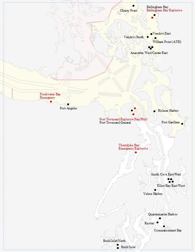
60 4-8
61 Section 5 VHF Frequency Monitoring Areas Ferry Crossing Routes Commercial Salmon Management & Catch Reporting Areas Cooperative Vessel Traffic Service (CVTS) Advance Report & Reporting Area Message Markers and SMCP IMO Area To Be Avoided off the Washington Coast Puget Sound Area Security Zones 5-1

62 VHF Frequency Monitoring Areas 5-2

63 Ferry Crossings Ferry Crossing Routes 5-3

64 Commercial Salmon Management and Catch Reporting Areas Treaty all-gear fishing, including the use of set-nets, may be encountered in all areas throughout the entire year. Areas 4B, 5, 6C, 10A, 10F and 11A are often open for long periods and may be congested. Navigate with extreme caution and report any unattended nets to VTS Commercial salmon gillnet fishing is most prevalent in the autumn in areas 7, 7A, 7B, 8A, 9, 10 and 11. Special navigation requirements may be enacted by VTS depending on the level of vessel congestion. Sport recreational fishing is common throughout the entire Puget Sound region. Concentrations historically occur in the western Strait of Juan de Fuca in the vicinity of Neah Bay and Clallam Bay, Port Angeles, Dungeness, Partridge Bank to Marrowstone Island, Point No Point, Jefferson Head, Shilshole, Elliott Bay, Des Moines to Point Robinson, and Commencement Bay. 5-4
65 Message Markers, SMCP and English Language Message Markers: When language problems arise, communications may be preceded by the following message markers: Questions: request for information. Question, what is your pilot station time, over? Answer: the reply to a previous question. Answer, fourteen-thirty, over. Request: a request for action from others with respect to the ship. Information: observed facts. Intention: notice of immediate planned navigational actions. Warning: information about dangers. Advice: a recommendation to correct a hazardous condition. Instruction: a lawful order Clearance: an authorization to proceed subject to conditions. Standard Marine Communication Phrases: As navigational and safety communications must be precise, simple and unambiguous, so as to avoid confusion and error, there is a need to standardize the language used. When transmitting intentions in English over the radio to Prince Rupert, Seattle, or Victoria Traffic, where precision in English may be of concern, vessels should use the Standard Marine Communication Phrases of the Marine National Vocabulary available from the IMO. English Language: The language normally used on board a ship is the national language of the crew. However, crews of ships trading internationally must necessarily conduct navigational and safety communications with persons who may be unable to understand their national language. All communications with Prince Rupert, Seattle or Victoria Traffic must be made in clear, unbroken English. At least one person capable of conducting two-way radio communication using the English language must be present on the bridge at all times within the CVTS area. (Back to TOC) 5-5
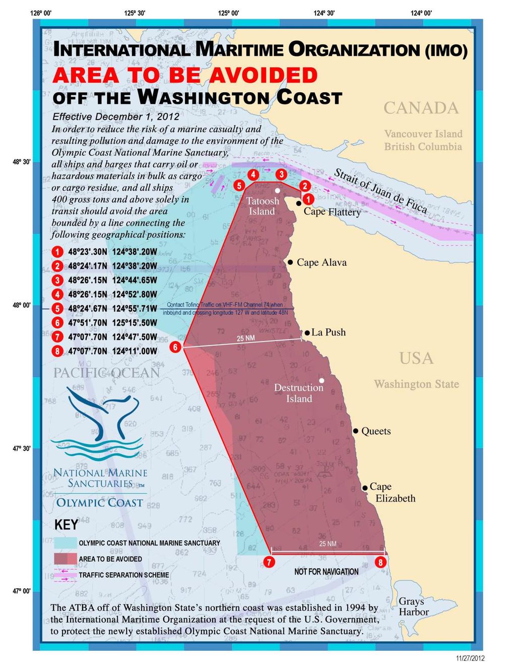
66 5-6
67 5-7
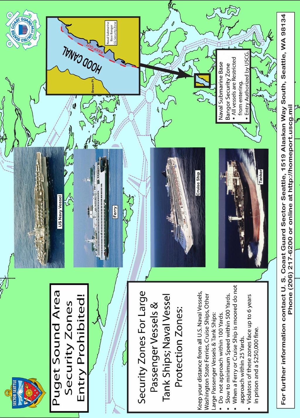
68 5-8
69 5-9
1972 Collision Regulations definition of a vessel. Note: Vessel length is measured from end to end over the deck, excluding sheer.
 User Definitions VMRS (Vessel Movement Reporting System) Users: Every power-driven vessel of 40 meters (approximately 131 feet) or more in length, while navigating; Every commercial vessel engaged in towing
Vessel Traffic in the Salish Sea Mitigating Risk... Captain Joe Raymond Coast Sector Puget Sound
 Vessel Traffic in the Salish Sea Mitigating Risk.... Captain Joe Raymond Coast Sector Puget Sound Overview Prevention Waterways Management Oil Spill Data Mitigating Risks Sector Puget Sound AOR Blan k
Delaware River Vessel Reporting System Mariners Advisory Committee For
 Delaware River Vessel Reporting System Mariners Advisory Committee For the Bay and River Delaware The Mariner's Advisory Committee is comprised of Master Mariners, River Pilots, and concerns itself with
VTS Prince William Sound User s Manual May 2017 Edition. U.S. Coast Guard. Vessel Traffic Service Prince William Sound.
 U.S. Coast Guard Vessel Traffic Service Prince William Sound User s Manual Twelfth Edition May 2017 1 Notes 2 Purpose of this Manual: With the implementation of Vessel Traffic Management regulations contained
VESSEL TRAFFIC SERVICE HOUSTON/GALVESTON
 VESSEL TRAFFIC SERVICE HOUSTON/GALVESTON USER'S MANUAL Revised August 2017 VMRS Users (Full Participation): USER GROUPS These vessels must monitor the designated VTS VHF-FM frequency, make reports to the
TICES TO MARINERS 1 TO 46 ANNUAL EDITION 2018 SECTION A AIDS TO NAVIGATION AND MARINE SAFETY
 A5 NAVIGATION SAFETY 10 Routeing of Ships 1 GENERAL 1.1 Rule 10 of the Collision Regulations applies to all ships navigating in or near a routeing system. 1.2 The information on ships' routeing in this
World Shipping Council. National Oceanographic and Atmospheric Administration
 Comments of the World Shipping Council Submitted to the National Oceanographic and Atmospheric Administration In the matter of Endangered and Threatened Species; Petition for Rulemaking to Establish a
OSAKA MARTIS USER MANUAL TABLE OF CONTENTS
 OSAKA MARTIS USER MANUAL TABLE OF CONTENTS Ⅰ Ⅱ Ⅲ INTRODUCTION OPERATIONAL CONCEPT OF "Osaka MARTIS" IMPORTANT NAVIGATIONAL RULES Ⅳ COMMUNICATION 1 VHF Channels 2 Language Ⅴ PRE-ENTRY REPORT AND POSITION
International regulations and guidelines for maritime spatial planning related to safe distances to multiple offshore structures (e.g.
 International regulations and guidelines for maritime spatial planning related to safe distances to multiple offshore structures (e.g. wind farms) Introduction This is a summary of the most important international
COOPERATIVE VESSEL TRAFFIC SERVICE (CVTS) TAMPA BAY, FLORIDA
 TAMPA BAY, FLORIDA") COOPERATIVE VESSEL TRAFFIC SERVICE (CVTS) TAMPA BAY, FLORIDA USERS MANUAL Oct 2010 1 st Edition Serving the Port of Tampa, Port Manatee, Port of Saint Petersburg, and the Waterways of Tampa Bay 1 Table
COOPERATIVE VESSEL TRAFFIC SERVICE (CVTS) TAMPA BAY, FLORIDA USERS MANUAL Oct 2010 1 st Edition Serving the Port of Tampa, Port Manatee, Port of Saint Petersburg, and the Waterways of Tampa Bay 1 Table
VESSEL TRAFFIC SERVICE NEW YORK USER'S MANUAL
 USER S MANUAL Revised March 2016 VESSEL TRAFFIC SERVICE NEW YORK USER'S MANUAL Revised March 2016 TABLE OF CONTENTS SECTION Page Table of Contents 1 Introduction 2 Vessel Traffic Management (33 CFR 161)
The LA/LB Harbors handle more than 5,500 commercial vessel arrivals per year (excluding local coastwise and Catalina Island traffic).
.") X. SMALL CRAFT For the purpose of the Los Angeles and Long Beach Harbor Safety Plan, pleasure vessels, commercial fishing vessels and sportfishing boats are designated as small craft. A. BACKGROUND: The
X. SMALL CRAFT For the purpose of the Los Angeles and Long Beach Harbor Safety Plan, pleasure vessels, commercial fishing vessels and sportfishing boats are designated as small craft. A. BACKGROUND: The
VESSEL TRAFFIC SERVICE HOUSTON/GALVESTON
 VESSEL TRAFFIC SERVICE HOUSTON/GALVESTON USER'S MANUAL Revised July 2008 VMRS Users (Full Participation): USER GROUPS These vessels must monitor the designated VTS VHF-FM frequency, make reports to the
AK-APC-NTV Operating Procedures for Cargo and Passenger Non Tank Vessels Transiting and Operating in Alaska Waters December 26, 2015
 AK-APC-NTV Operating Procedures for Cargo and Passenger Non Tank Vessels Transiting and Operating in Alaska Waters December 26, 2015 The Alternative Planning Criteria (APC) Operating Procedures were developed
3.1 CANADIAN COAST GUARD RESPONSIBILITIES
 DFO/2017-1990 RADIO AIDS TO MARINE NAVIGATION 2017 PART 3 The purpose of this section is to describe to shipboard personnel the ship reporting procedures to be followed by vessels when within or intending
properly applied assessment in the use.1 landmarks.1 approved in-service of ECDIS is not experience The primary method of fixing required for those
 STCW Code Table A-II/3 Specification of minimum standard of for officers in charge of a navigational watch and for masters on ships of less than 500 gross tonnage engaged on near-coastal voyages Ref: https://www.edumaritime.net/stcw-code
August April 18,2008 First Revision
 August 15 2011 Slide 01 April 18,2008 First Revision August 15, 2011 Text converted to Tables for ease of formatting instructor guide. Slide 23 Sound Signals Corrected Danger Signal 5 or More Short Blasts
MARINER S GUIDE TO THE FORTH
 MARINER S GUIDE TO THE FORTH INTRODUCTION 1. The Statutory Harbour Authority s area of jurisdiction on the River and Firth of Forth ( The Forth ) extends from approximately one mile west of the Isle of
LOCAL NOTICE TO MARINERS
 USCG Notice to Mariners 3/7/18 (View full Notice here) LNM 10/18 Coast Guard District 1: U.S. Department of Homeland Security United States Coast Guard LOCAL NOTICE TO MARINERS COASTAL WATERS FROM EASTPORT,
WAK-APC-T Operating Procedures for Oil Tankers Transiting or Operating in Western Alaska Waters
 WAK-APC-T Operating Procedures for Oil Tankers Transiting or Operating in Western Alaska Waters RECORD OF CHANGE WAK-APC-T Operating Procedures for Oil Tankers Transiting or Operating In Western Alaska
VESSEL TRAFFIC SERVICE NEW YORK USER'S MANUAL Revised September 2018
 USER S MANUAL Revised September 2018 VESSEL TRAFFIC SERVICE NEW YORK USER'S MANUAL Revised September 2018 TABLE OF CONTENTS SECTION Page Table of Contents 1 Introduction 2 Contact Information 4 Vessel
LOWER MISSISSIPPI RIVER PRE-ENTRY INFORMATION
 LOWER MISSISSIPPI RIVER PRE-ENTRY INFORMATION Notice of Arrivals Prior to Arrival at any U.S. port, the vessel master should ensure a complete and accurate Notice of Arrival has been submitted to National
APC Operating Procedures Oil Tankers
 APC Operating Procedures Oil Tankers August 2013 The APC Operating Procedures were developed to aid the Master and Operator of oil tankers in ensuring all aspects of the APC are complied with when transiting
KANMON KAIKYO VESSEL TRAFFIC SERVICE CENTER KANMON MARTIS USER MANUAL TABLE OF CONTENTS Ⅱ OPERATIONAL CONCEPT OF THE "KANMON MARTIS" 1
 KANMON KAIKYO VESSEL TRAFFIC SERVICE CENTER KANMON MARTIS USER MANUAL TABLE OF CONTENTS Ⅰ INTRODUCTION 1 Ⅱ OPERATIONAL CONCEPT OF THE "KANMON MARTIS" 1 Ⅲ IMPORTANT NAVIGATIONAL RULES 2 Ⅳ COMMUNICATION
Subj: CHANGE 2 to USER MANUAL FOR VESSEL MOVEMENT REPORTING SYSTEM (VMRS) BUZZARDS BAY
 BUZZARDS BAY") Commander U.S. Coast Guard Sector Southeastern New England Prevention Department 20 Risho Ave East Providence, RI 02914-1208 Staff Symbol: Phone: 401-435-2351 Fax: 401-435-2399 Email: Edward.G.LeBlanc@uscg.mil
Commander U.S. Coast Guard Sector Southeastern New England Prevention Department 20 Risho Ave East Providence, RI 02914-1208 Staff Symbol: Phone: 401-435-2351 Fax: 401-435-2399 Email: Edward.G.LeBlanc@uscg.mil
Important Information for Yachts & Agents
 Important Information for Yachts & Agents 1. The Yacht Services of Alaska agent is your contact for all requests for pilotage and pilot boat services. Refer all communication regarding pilotage to them.
IMO RESOLUTION A.960(23) Adopted 5 December 2003 (Agenda item 17)
 Adopted 5 December 2003 (Agenda item 17)") INTERNATIONAL MARITIME ORGANIZATION E IMO ASSEMBLY 23rd session Agenda item 17 A 23/Res.960 5 March 2004 Original: ENGLISH RESOLUTION A.960(23) Adopted 5 December 2003 (Agenda item 17) RECOMMENDATIONS
INTERNATIONAL MARITIME ORGANIZATION E IMO ASSEMBLY 23rd session Agenda item 17 A 23/Res.960 5 March 2004 Original: ENGLISH RESOLUTION A.960(23) Adopted 5 December 2003 (Agenda item 17) RECOMMENDATIONS
ASSOCIATED BRITISH PORTS - LOWESTOFT
 ASSOCIATED BRITISH PORTS - LOWESTOFT PILOTAGE DIRECTION (With Amendments To 01/02/2012) 1. AUTHORISATION Pilotage Act 1987. Associated British Ports Lowestoft (Pilotage) Harbour Revision Order 1988. 2.
National Maritime Center
 National Maritime Center Providing Credentials to Mariners Q301 Rules of the Road-Inland (Sample Examination) Page 1 of 19 Choose the best answer to the following Multiple Choice Questions. NO reference
RESOLUTION MSC.161(78) (adopted on 17 May 2004) AMENDMENTS TO THE EXISTING MANDATORY SHIP REPORTING SYSTEM "THE TORRES STRAIT AND INNER ROUTE OF THE
 (adopted on 17 May 2004) AMENDMENTS TO THE EXISTING MANDATORY SHIP REPORTING SYSTEM THE TORRES STRAIT AND INNER ROUTE OF THE") MSC 78/26/Add.2 RESOLUTION MSC.161(78) REPORTING SYSTEM THE TORRES STRAIT AND INNER ROUTE OF THE GREAT BARRIER REEF THE MARITIME SAFETY COMMITTEE, RECALLING Article 28(b) of the Convention on the International
MSC 78/26/Add.2 RESOLUTION MSC.161(78) REPORTING SYSTEM THE TORRES STRAIT AND INNER ROUTE OF THE GREAT BARRIER REEF THE MARITIME SAFETY COMMITTEE, RECALLING Article 28(b) of the Convention on the International
General Directions for Navigation in the Forth
 General Directions for Navigation in the Forth Forth Ports Limited, in exercise of their powers under section 3 of the Forth Ports Authority Order 1980 and having carried out the consultations required
Enhanced Discussion of Requirements for Commercial Fishing Vessels
 Update on U.S. Commercial Fishing Industry Vessel Requirements Based On Section 604 of the Coast Guard Authorization Act of 2010 (Public Law 111-281) And Section 305 of the Coast Guard and Maritime Transportation
WORK-REST REQUIREMENTS FOR PILOTS
 AN ORDER OF THE BOARD OF PILOT COMMISSIONERS FOR THE PORT OF CORPUS CHRISTI AUTHORITY REGARDING WORK-REST REQUIREMENTS FOR PILOTS AND COMBINED BEAM RESTRICTION Whereas, the current Rules and Regulations
GENERAL LIMITATIONS AND RESTRICTIONS. Draft Restrictions
 RULES AND REGULATIONS GOVERNING PILOTS AND PILOTAGE ON THE CORPUS CHRISTI SHIP CHANNEL EFFECTIVE AUGUST 1, 2013 AMENDED EFFECTIVE MAY 13, 2014 AMENDED EFFECTIVE OCTOBER 1, 2014 I GENERAL The Rules and
Towed Barge Standard of Care
 Lower Columbia Region Harbor Safety Committee Towed Barge Standard of Care Page 1 of 6 A. 1. Purpose The Columbia River is intended to eliminate conflicts between towing vessels conducting astern towing
Rules Practice Exam 11
 1 BOTH INTERNATIONAL & INLAND While underway in fog, you hear a vessel sound one prolonged blast followed by two short blasts on the whistle. What does this signal indicate? A. A vessel towing B. A vessel
This direction contains the requirements for the compulsory pilotage areas within the Auckland region. This
 Harbourmaster s Direction 2-15 Pilotage Foreword This direction contains the requirements for the compulsory pilotage areas within the Auckland region. This direction updates and supersedes previous Harbourmaster
GUIDELINES FOR NAVIGATION UNDER THE CONFEDERATION BRIDGE
 (12/2009) GUIDELINES FOR NAVIGATION UNDER THE CONFEDERATION BRIDGE REVISION 1 DECEMBER 2009 Responsible Authority The Regional Director Marine Safety Atlantic Region is responsible for this document, including
Rules Practice Exam 12
 1 INLAND ONLY You are on vessel "A", and vessel "B" desires to overtake you on your starboard side as shown. After the vessels have exchanged one blast signals, you should. Diagram 31 A. alter course to
2005 ABC. Chapter 3 Part 2. Navigating with ATON's. Revision to D-13 Local Notes. Instructor Notes for Mike Brough. Mike Brough
 2005 ABC Chapter 3 Part 2 Navigating with ATON's Revision to D-13 Local Notes Instructor Notes for Mike Brough Mike Brough June 24 2008 June 24 2008 Slide 1 June 24 2008 New graphics Navigating on Water
ROUTEING MEASURES OTHER THAN TRAFFIC SEPARATION SCHEMES
 E 4 ALBERT EMBANKMENT LONDON SE1 7SR Telephone: +44 (0)20 7735 7611 Fax: +44 (0)20 7587 3210 SN.1/Circ.317 4 December 2012 ROUTEING MEASURES OTHER THAN TRAFFIC SEPARATION SCHEMES 1 The Maritime Safety
Rules Practice Exam 7
 1 INTERNATIONAL ONLY The light which may be used with a vessel's whistle is to be. A. used when the whistle is broken B. used prior to sounding the whistle C. used only at night D. a white light 2 INTERNATIONAL
Rules Practice Exam 14
 1 BOTH INTERNATIONAL & INLAND Additional light signals are provided in the Annexes to the Rules for vessels. A. engaged in fishing B. not under command C. engaged in towing D. under sail 2 BOTH INTERNATIONAL
NavRule Practice Exam, 70 Series Practice April 24, Labeled F (I received a reply from the testing service that all these answers were
 1. INTERNATIONAL & INLAND An all-round flashing yellow light may be exhibited by a(n)? a. vessel laying cable b. vessel towing a submerged object c. vessel not under command d. air cushion vessel 2. INTERNATIONAL
References: Manual Chapt. 9 ISO 9001 par.7 ISO par. 4 ISM Code par. 7; 8
 SQEMS OPERATING PROCEDURE OP-SAF-03 1 of 5 References: Manual Chapt. 9 ISO 9001 par.7 ISO 14001 par. 4 ISM Code par. 7; 8 1. SCOPE This Procedure establishes criteria for the control and management of
IMO ROUTEING OF SHIPS, SHIP REPORTING AND RELATED MATTERS
 INTERNATIONAL MARITIME ORGANIZATION E IMO SUB-COMMITTEE ON SAFETY OF NAVIGATION 52nd session Agenda item 3 NAV 52/3/9 13 April 2006 Original: ENGLISH ROUTEING OF SHIPS, SHIP REPORTING AND RELATED MATTERS
GENERAL GUIDELINES FOR VESSELS TRANSITING RESTRICTED WATERWAYS OR PORTS
 GENERAL GUIDELINES FOR VESSELS TRANSITING RESTRICTED WATERWAYS OR PORTS Revised: March 5, 2018 TABLE OF CONTENTS GENERAL DEFINITIONS... 2 VESSEL SPACING... 3 HORIZONTAL CLEARANCE... 3 UNDER-KEEL CLEARANCE
PILOTAGE INFORMATION
 PILOTAGE INFORMATION Revised A PILOTAGE DIRECTIONS The Gloucester Harbour Trustees is the Competent Harbour Authority for the Gloucester Harbour under the Pilotage Act 1987 and responsible for the provision
National Maritime Center
 National Maritime Center Providing Credentials to Mariners Able Seaman Unlimited, Limited, Special, Special OSV, Sail, Fishing Industry (Sample Examination) Page 1 of 17 Choose the best answer to the following
Task 1: Pilot Perspectives on Routing for GPT-calling Vessels
 Gateway Pacific Terminal Vessel Traffic and Risk Assessment Study Task 1: Pilot Perspectives on Routing for GPT-calling Vessels Prepared for Pacific International Terminals, Inc. Prepared by The Glosten
GENERAL LIMITATIONS AND RESTRICTIONS. LNGC Temporary Exemption (Effective August 21, 2018)
") RULES AND REGULATIONS GOVERNING PILOTS AND PILOTAGE ON THE CORPUS CHRISTI SHIP CHANNEL EFFECTIVE AUGUST 1, 2013 AMENDED EFFECTIVE MAY 13, 2014 AMENDED EFFECTIVE OCTOBER 1, 2014 AMENDED EFFECTIVE JANUARY
RULES AND REGULATIONS GOVERNING PILOTS AND PILOTAGE ON THE CORPUS CHRISTI SHIP CHANNEL EFFECTIVE AUGUST 1, 2013 AMENDED EFFECTIVE MAY 13, 2014 AMENDED EFFECTIVE OCTOBER 1, 2014 AMENDED EFFECTIVE JANUARY
U.S. Department Of Homeland Security
 U.S. Department Of Homeland Security CHANGE NUMBER DATE OF CHANGE RECORD OF CHANGES DATE ENTERED BY WHOM ENTERED i CONTENTS INTRODUCTION... iv LEGAL CITATIONS... vi CONVERSION TABLE... vii NAVIGATION RULES...
Harbor Safety Committee HEAVY WEATHER (WX)
") HEAVY WEATHER (WX) SOC Quick Reference Risk Petroleum transfers Mooring buoys- Operating Policies and Weather Criteria General mooring policies, breakaway prevention Derelict and unattended vessels (abandoned
HEAVY WEATHER (WX) SOC Quick Reference Risk Petroleum transfers Mooring buoys- Operating Policies and Weather Criteria General mooring policies, breakaway prevention Derelict and unattended vessels (abandoned
SECTION THREE PILOTAGE DEFINITIONS
 SECTION THREE PILOTAGE First Revised Page... 30 Original Page... 30 DEFINITIONS (a) Pilotage is the charge, calculated in accordance with the pilotage rates named in this Tariff, assessed against a vessel,
COAST GUARD ADVISORY NOTICE (CGAN ) To: Distribution Date: September 1, 2017
 To: Distribution Date: September 1, 2017") Commander United States Coast Guard Sector New York 212 Coast Guard Drive Staten Island, NY 10305 Staff Symbol: (spw) Phone: (718) 354-2353 Fax: (718) 354-4190 COAST GUARD ADVISORY NOTICE (CGAN 2017-016)
Commander United States Coast Guard Sector New York 212 Coast Guard Drive Staten Island, NY 10305 Staff Symbol: (spw) Phone: (718) 354-2353 Fax: (718) 354-4190 COAST GUARD ADVISORY NOTICE (CGAN 2017-016)
Pilotage Directions 2017
 Pilotage Directions 2017 1. Commencement These Pilotage Directions shall come into force on 31 st August 2017 on which date the existing Pilotage Directions are revoked. 2. Short Title These Pilotage Directions
New Requirements for Commercial Fishing Industry Vessels Section 604 Coast Guard Authorization Act of 2010 (Public Law )
") New Requirements for Commercial Fishing Industry Vessels Section 604 Coast Guard Authorization Act of 2010 (Public Law 111-281) On October 15, 2010, the President signed the law that included provisions
New Requirements for Commercial Fishing Industry Vessels Section 604 Coast Guard Authorization Act of 2010 (Public Law 111-281) On October 15, 2010, the President signed the law that included provisions
NOTICE TO MARINERS. No 03 of Port of Southampton Precautionary Area (Thorn Channel)
") NOTICE TO MARINERS No 03 of 2016 (Update and Re-Issue of Notice to Mariners No 03 of 2014) Port of Southampton Precautionary Area (Thorn Channel) 1 NOTICE IS HEREBY GIVEN that all vessels navigating within
NOTICE TO MARINERS No 03 of 2016 (Update and Re-Issue of Notice to Mariners No 03 of 2014) Port of Southampton Precautionary Area (Thorn Channel) 1 NOTICE IS HEREBY GIVEN that all vessels navigating within
RECORD OF CHANGES DATE EFFECTIVE
 RECORD OF CHANGES CHANGE NUMBER DATE OF CHANGE DATE EFFECTIVE BY WHOM ENTERED CONTENTS INTRODUCTION... i LEGAL CITATIONS... iii CONVERSION TABLE... iv NAVIGATION RULES AND REGULATIONS INTERNATIONAL AND
MAC Transit Advisories as of April 30, 2018
 MAC Transit Advisories as of April 30, 2018 The Mariners Advisory Committee for the Bay and River Delaware was established in October 1964. Its members and associate members are mainly comprised of master
Harbourmaster s Office Operation of Superyacht in the Auckland Region Navigation Safety Operating Requirements
 Harbourmaster s Office Operation of Superyacht in the Auckland Region Navigation Safety Operating Requirements Foreword Maritime Rule 90 requires that every vessel of 500 Gross tonnage or greater carries
National Maritime Center
 National Maritime Center Providing Credentials to Mariners U.S.C.G. Merchant Marine Exam (Sample Examination) Page 1 of 22 U.S.C.G. Merchant Marine Exam: Illustrations: 10 Choose the best answer to the
Harbourmaster s Office Tamaki River. Navigation Safety Operating Requirements 2014
 Harbourmaster s Office Tamaki River Navigation Safety Operating Requirements 2014 Auckland Council Harbourmaster s Office TAMAKI RIVER Navigation Safety Operating Requirements FOREWARD The purpose of these
Rules Practice Exam 9
 1 BOTH INTERNATIONAL & INLAND If your vessel is underway in fog and you hear one prolonged and three short blasts, this is a. A. vessel not under command B. sailing vessel C. vessel being towed (manned)
You must stop your. pass with caution on the port side of vessel "B" The vessel moving upstream against the current
 BK NUM ANS QUESTION ANSWER A ANSWER B ANSWER C ANSWER D ILLUST 1 1 C 1 2 B INLAND ONLY You are navigating in a narrow channel and must remain in the channel for safe operation. Another vessel is crossing
PART 3 VESSEL TRAFFIC SERVICES (VTS) PACIFIC AND WESTERN ARCTIC
 PACIFIC AND WESTERN ARCTIC") PART 3 VESSEL TRAFFIC SERVICES (VTS) PACIFIC AND WESTERN ARCTIC The purpose of this section is to describe to shipboard personnel the ship reporting procedures to be followed by vessels when within or
PART 3 VESSEL TRAFFIC SERVICES (VTS) PACIFIC AND WESTERN ARCTIC The purpose of this section is to describe to shipboard personnel the ship reporting procedures to be followed by vessels when within or
SECTION II NM 26/10 NAVIGATION PUBLICATIONS ALMANACS CORRECTIONS
 NAVIGATION PUBLICATIONS ALMANACS CORRECTIONS NAUTICAL ALMANAC Ed 2011 NEW EDITION (NGA) 26/10 SAILING DIRECTIONS CORRECTIONS PUB 140 8 Ed 2010 NEW EDITION (NGA) 26/10 COAST PILOT CORRECTIONS COAST PILOT
iii) Satisfactory completion of approved training in the following:
 Satisfactory completion of approved training in the following:") Enclosure (1) to NVIC 13-14 DISCUSSION OF QUALIFICATION REQUIREMENTS FOR MASTER AND OFFICER IN CHARGE OF A NAVIGATIONAL WATCH ON VESSELS OF LESS THAN 500 GT LIMITED TO NEAR-COASTAL WATERS 1. GENERAL. This
Enclosure (1) to NVIC 13-14 DISCUSSION OF QUALIFICATION REQUIREMENTS FOR MASTER AND OFFICER IN CHARGE OF A NAVIGATIONAL WATCH ON VESSELS OF LESS THAN 500 GT LIMITED TO NEAR-COASTAL WATERS 1. GENERAL. This
National Maritime Center
 National Maritime Center Providing Credentials to Mariners (Sample Examination) Page 1 of 19 Choose the best answer to the following multiple choice questions. NO reference materials are authorized for
Rules of the Road. United States Power Squadrons USPS University
 Rules of the Road United States Power Squadrons USPS University Seminar and contents copyrighted by USPS 2008 Per Inland Rules: Boats 12 m or greater must carry a copy of these rules Seminar Reference
Rules Practice Exam 5
 1 BOTH INTERNATIONAL & INLAND Vessel "A" (towing) and vessel "B" are meeting as shown. In this situation, which statement is TRUE? Diagram 12 A. Both vessels should alter course to starboard and pass port
Movement and traffic procedures
 Section 3 Movement and traffic procedures Maritime Safety Queensland, through the authority of the Regional Harbour Master, has jurisdiction over the safe movement of all shipping within the pilotage area.
MARINE SAFETY REGULATION 2016 EXEMPTION ORDER. Clause 140(1)
") MARINE SAFETY REGULATION 2016 EXEMPTION ORDER Clause 140(1) I, Angus Mitchell, Executive Director, NSW Maritime, a delegate of Roads and Maritime Services (RMS), pursuant to clause 140(1) of the Marine
MARINE SAFETY REGULATION 2016 EXEMPTION ORDER Clause 140(1) I, Angus Mitchell, Executive Director, NSW Maritime, a delegate of Roads and Maritime Services (RMS), pursuant to clause 140(1) of the Marine
EBA Position Statement AIS Virtual Aids to Navigation
 EBA Position Statement AIS Virtual Aids to Navigation Document date: 17 October 2015 Latest update: 9 December 2015 Executive Summary The European Boating Association 1 (EBA) recognises the value of Automatic
DUBLIN PORT COMPANY PILOTAGE BYE-LAWS. 1st July Dublin Port Company Pilotage Bye-Laws, 1 st July 2018 Page 1
 DUBLIN PORT COMPANY PILOTAGE BYE-LAWS 1st July 2018 Dublin Port Company Pilotage Bye-Laws, 1 st July 2018 Page 1 Contents PILOTAGE BYE-LAWS... 3 1) Interpretation... 3 2) Compulsory Pilotage and Exempted
SS&S Chapter 8 Instructor Guide
 SS&S Chapter 8 Instructor Guide The Rules of the Nautical Road The PowerPoints (PPT) slides for this SS&S chapter were copied from the BS&S-13 th Ed PPT because they are identical. Only the chapter numbers
LAPWARE, LLC. Since 2002
 CORRECTED THROUGH 23 NOV 2011 LAPWARE, LLC www.lapware.org Since 2002 www.lapwareengine.org Since 2011 CHANGE NUMBER DATE OF CHANGE RECORD OF CHANGES DATE ENTERED BY WHOM ENTERED 001 25 MAR 99 ONGOING
Appendix HK1 HKSF Prescriptions
 Appendix HK1 HKSF Prescriptions Introduction Effective date Rule The HKSF prescribes that these rules become effective in Hong Kong on 1 January 2017. Prescription 67 Damages 1 No claim for damages arising
South African Maritime Safety Authority Ref: SM6/5/2/1 /1
 South African Maritime Safety Authority Ref: SM6/5/2/1 /1 Date: 27 March 2014 Marine Notice 6 of 2014 Sail and Motor Yachts of over 25 GT but less than 100 GT used for Charter Purposes TO ALL PRINCIPAL
LOCAL NOTICE TO MARINERS
 USCG Notice to Mariners 3/26/15 (View full Notice here) LNM 12/15 Coast Guard District 1 : U.S. Department of Homeland Security United States Coast Guard LOCAL NOTICE TO MARINERS COASTAL WATERS FROM EASTPORT,
Adverse Weather and Management of Vessel Traffic
 Adverse Weather and Management of Vessel Traffic VTS PRINCE WILLIAM SOUND LT Allie Ferko, VTS Director 01 May 2014 Vessel Movement Reporting System 33CFR161.16 VMRS Users are defined as: Power driven vessels
ANCHORING. Small Craft Advisories (sustained winds 21 to 33 knots
 SOC Quick Reference ANCHORING Risk General Information All Puget Sound regions other than Smith Cove East and West in Elliott Bay and Commencement Bay All Weather Visibility Gale Warnings (sustained winds
World Shipping Council. Bureau of Ocean Energy Management Department of the Interior
 Comments of the World Shipping Council Submitted to the Bureau of Ocean Energy Management Department of the Interior In the matter of Commercial Leasing for Wind Power Development on the Outer Continental
Incident Report. Close Quarters Pegasus II & Distraction. 26 April 2006 Class B
 Incident Report Close Quarters Pegasus II & Distraction 26 April 2006 Class B NARRATIVE Pegasus II (See Photograph 1 Pegasus II) is a 15.46 metre commercial fishing vessel with a gross tonnage of 40. She
COMDTINST M D MAR
 Commandant United States Coast Guard 2100 Second St., SW United States Coast Guard Washington, DC 20593-0001 Staff Symbol: G-MW Phone: 202-267-0407 Fax: 202-267-4826 COMDTINST M16672.2D MAR 25 1999 COMMANDANT
PILOTAGE DIRECTIONS REVIEWED DECEMBER 2016
 PILOTAGE DIRECTIONS REVIEWED DECEMBER 2016 REVISION LIST Revision No. Date Details Approved by: Original All sections 12 Dec 2013 First edition of C W Brand v1.0 Pilotage Directions Revision 2 all sections
 ON SHIPS OF 200 GRT/500 GT OR MORE Assessment Sheets Enclosure (1) to CG-543 Policy Letter 11-07 ASSESSMENT NO. OICNW-1-1A COMPETENCE: Plan and conduct a passage and determine position KNOWLEDGE, UNDERSTANDING
Rule 18 - Responsibilities between vessels
 Except where Rules 9, 10 and 13 otherwise require: (a) A power-driven vessel underway shall keep out of the way of: (i) a vessel not under command; (ii) a vessel restricted in her ability to manoeuvre;
HELSINKI COMMISSION HELCOM SAFE NAV 4/2014 Group of Experts on Safety of Navigation Fourth Meeting Helsinki, Finland, 4 February 2014
 HELSINKI COMMISSION HELCOM SAFE NAV 4/2014 Group of Experts on Safety of Navigation Fourth Meeting Helsinki, Finland, 4 February 2014 Agenda Item 3 Accidents and ship traffic in the Baltic Sea Document
Vessel Traffic Service Lower Mississippi River
 Vessel Traffic Service Lower Mississippi River User Manual Third Edition 2013 Available for self printing at: http://homeport.uscg.mil TABLE OF CONTENTS INTRODUCTION... 1 GENERAL INFORMATION... 1 DEFINITIONS...
 7 The Guidelines of Measures for preventing Typhoon Disaster ( Objective ) Article1 The objective of this guideline is to establish steps necessary to implement the measures for preventing typhoon
Visiting Lake Macquarie
 Visiting Lake Macquarie Lake Macquarie is the largest coastal salt water lake in Australia and is a prime boating destination for both small and large vessels. Many sailing regattas and fishing activities
NavRule Practice Exam, 70 Series Practice April 18, Labeled C have been copied to collection
 1C. INTERNATIONAL & INLAND There are two classes of vessel which, to the extent necessary to carry out their work, do not have to comply with the rule regarding traffic separation schemes. One of these
Round The County 2018 November 10 th & 11 th, 2018 Sailing Instructions Organizing Authority: Orcas Island Yacht Club and Friday Harbor Sailing Club
 Round The County 2018 November 10 th & 11 th, 2018 Sailing Instructions Organizing Authority: Orcas Island Yacht Club and Friday Harbor Sailing Club 1. Rules 1.1. The Regatta will be governed by the rules
TOWING OFFICER ASSESSMENT RECORD
 TOWING OFFICER ASSESSMENT RECORD NEAR COASTAL / OCEANS SIGNATED EXAMINER INFORMATION All Designated Examiners (s) signing off successful completion of practical assessments should provide the information
Introduction of the term Traffic Control Zone and formalization of Fraser River Traffic Control Zone procedures
 Consideration Report Introduction of the term Traffic Control Zone and formalization of Fraser River Traffic Control Zone procedures Background Under the Canada Marine Act, all Canada Port Authorities
Pacific Pilotage Authority Pilotage Waiver Standard of Care. Implementation Guidelines
 Pacific Pilotage Authority Pilotage Waiver Standard of Care Introduction Implementation Guidelines PPA waivers are granted subject to the Pilotage Act, Pacific Pilotage Regulations and these Implementation
1. PURPOSE. This instruction forwards International and Inland Navigation Rules and Regulations for use by Coast Guard personnel.
 U.S. Department of Transportation United States Coast Guard Commandant United States Coast Guard Mailing Address: 2100 2nd Street, S.W. Washington, DC 0593-001 Phone: (202) 267-0352 COMMANDANT INSTRUCTION
Unmanned ships and navigation: the regulatory framework
 Unmanned ships and navigation: the regulatory framework Robert Veal LLB, LLM (Barrister) Research Fellow, Institute of Maritime Law Fundamental questions What are the regulatory obligations of unmanned
ADANI PORTS & SEZ LTD. ++ MUNDRA PORT ++ GENERAL INFORMATION
 ADANI PORTS & SEZ LTD. ++ MUNDRA PORT ++ GENERAL INFORMATION LOCATION Mundra Port is all weather, independent, commercial port with geographical and hydrological advantages on the West Coast of India,