Coral Reef Monitoring Protocol for the Overseas Territory Environmental Project British Virgin Islands
|
|
|
- Ralph Brown
- 5 years ago
- Views:
Transcription


1 Coral Reef Monitoring Protocol for the Overseas Territory Environmental Project British Virgin Islands Prepared by: Shannon Gore Marine Biologist - Conservation & Fisheries Department Ministry of Natural Resources & Labour Government of the British Virgin Islands Phone: / FAX: Sgore@gov.vg June 2006 Contacts: Finfun Peters Marine Coordinator- BVI National Parks Trust -P.O. Box 860 Road Town, Tortola British Virgin Islands - Tel: / 2069 Fax: Nancy Pascoe - Planning Coordinator -BVI National Parks Trust -P.O. Box 860 Road Town, Tortola British Virgin Islands - Tel: / 2069 Fax: Dr. Charles Sheppard Marine Scientist- University of Warwick charles.sheppard@warwick.ac.uk
2 CONTENTS I. Overview 3 Goals II. Equipment List 4 Monitoring site Setup Equipment 4 Monitoring Locations GPS Coordinates 4 III. Monitoring Station Set-Up 5 Monitoring Locations Map 6 Monitoring Stations- GPS Coordinates 7 IV. Coral Monitoring 8 Identification 8 Bio-indicators 8 Photography 9 V. Data Analysis 10 Intellectual Property Rights 10 APPENDICES 11 A. Identification of basic species 11 B. Identification of live versus recent & old mortality 15 C. Identification of coral diseases & predation 17 D. Identification of bleaching scales 19 E. Bio-indicators 20 *Cover photo by S. Gore 2
3 I. OVERVIEW This protocol is for monitoring coral reef / coastal ecosystems in the BVI as an indicator of overall coral reef health. Seven permanent monitoring stations were established in 2005 and more sites will be added as needed. Each monitoring station has five 20m transects. Each transect requires the person monitoring to identify (common name) what lies below the transect line at every 20 cm interval as well as identify the abundance of indicator species for overall reef health. Quantitative data collected will include percentages of coral coverage, recent mortality and coral disease. Digital photographs and video (Conservation & Fisheries Department) will also be taken along each transect to ensure qualitative and visual verification. Data will be collected on an annual basis or as needed. Monitoring staff require an open water scuba certification but since buoyancy is a critical skill to master for reef monitoring, an experienced diver should be used. The surveyors do not necessarily need a degree in marine biology, however, it is recommended those participating in coral monitoring have basic knowledge of coral identification and reef ecology. This protocol was established as part of the Overseas Territory Environmental Project (OTEP) entitled Assessment & Improved Management of New and Existing Marine Protected Areas in the British Virgin Islands. It is a collaborative project between the Conservation & Fisheries Department (CFD) and the BVI National Parks Trust (NPT). GOALS The goals of this protocol include: The establishment of permanent monitoring stations throughout the BVI that will be monitored annually or as needed, such as during a bleaching event in which reefs will be monitored on a monthly basis. Identifying the abundance and distribution of coral species as well as the abundance of bioindicators, diseases and recent mortality over a temporal scale. Identifying if Marine Protected Areas have aided in the sustainability of the natural resources found in the BVI. 3
 Large reel of fine nylon line (used for attaching buoys to substrate) Knife (used for cutting buoys in half) Scissors (used for cutting")
4 II. EQUIPMENT LIST EQUIPMENT FOR MONITORING SITE SET-UP Boat w/ anchor Dive Flag Dive equipment (mask, fins, BCD & regs, weight belt, air tanks) 10 Rebar stakes (2 ft each) per site Mallet / hammer 5 Small buoys (will be cut in half for sub-surface rebar markers) Large reel of fine nylon line (used for attaching buoys to substrate) Knife (used for cutting buoys in half) Scissors (used for cutting fine nylon line to secure buoys) Flagging tape GPS unit with waterproof bag EQUIPMENT FOR CORAL MONITORING Boat w/ anchor Dive Flag Dive equipment (mask, fins, BCD & regs, weight belt, air tanks) GPS unit with waterproof bag At least 2 Transect tapes (minimum of 50 meters) OR what is preferred: (at least 2) 25 Meters of weighted nylon line, marked from zero to 20m every 20 cm with small colored tie wraps Small 1 x 1 quadrat to attach weighted line 1 (See Figure 1.) Underwater slates OR what is preferred: Clipboard with waterproof paper OR waterproof notebook Pencils ID cards (coral id, disease & color chart) - Supplied by CFD Underwater camera / video camera OPTIONAL: Extra buoys (small), flagging tape, string to repair stations Figure 1. 10m weighted nylon line with 1 x 1 quadrat. 1 To make 1x1 quadrat attach four ½ diameter / 12 length PVC pipes with 4 ½ elbow joints to make a square quadrat. Holes should also be drilled in the PVC in order for the quadrat to sink. 4

5 III. MONITORING STATION SETUP The general location for each monitoring stations is determined by location of proposed marine protected area. Monitoring stations should be a good representation of the habitat in the area. During the initial set-up, rebar will be permanently driven into the substrate. Once the first rebar is in place at the monitoring station, the rebar is tied with flagging tape and a small sub-surface buoy is affixed to a coral head near the rebar in order to relocate the start of the transect line. (This is the first point in which coral monitoring will begin). Once the 20 meters is measured out, the second rebar is hammered into the substrate. It is not always possible to find a place to put the rebar at exactly 20m, in fact, it is best to measure out to 20.5m-21m from the first rebar 2. Once the rebar is in place, it is marked with flagging tape and a small sub-surface buoy is affixed to a coral head near the rebar. This will be Transect #1. (See Figure 2). Buoy marker Transect line Rebar with flagging tape Figure 2. Monitoring station setup. The next transect line ( Transect #2 ) will run approximately 5 meters parallel from the first transect. However, some sites will have 2-3 of the 20m transects running continuously from the first transect (i.e. a transect may run 40m but will still have a break at 20m). There is a total of five 20meter transects for each site. During the actual monitoring, a consistent way of determining transect number should be applied. These same steps will be repeated for each of the other monitoring stations. 2 Because monitoring requires the surveyor to observe corals every 20cm, this will allow a total of 100 points that must be monitored per 20m transect. 5
6 MONITORING LOCATIONS MAP Sandy Cay - Soft Coral Reef Great Thatch Montastrea Reef Little Thatch Montastrea Reef Norman Island - Montastrea Reef Peter Island West Soft Coral Reef Peter Island South - Soft Coral Reef Beef Island Hans Creek - Montastrea Reef Eustatia Sound Montastrea Reef Brandywine Bay Seagrass Bed Figure 3. Map of monitoring locations 6
7 MONITORING LOCATIONS GPS COORDINATES OTEP MONITORING SITE GPS COORDINATES GPS Settings: UTM Zone 20, NAD 1983 Conus SITE NAME TRANSECT# NORTHING EASTING SITE NAME TRANSECT # NORTHING EASTING Great Thatch Hans Creek Great Thatch Hans Creek Great Thatch Hans Creek Great Thatch Hans Creek Great Thatch Hans Creek Great Thatch Hans Creek Great Thatch Hans Creek Great Thatch Hans Creek Norman Island Hans Creek Norman Island Brandywine Bay Norman Island Brandywine Bay Norman Island Brandywine Bay Norman Island Brandywine Bay Norman Island Hans Creek Norman Island Sandy Cay Norman Island Sandy Cay Peter Island west Sandy Cay Peter Island west Sandy Cay Peter Island west Sandy Cay Peter Island west Sandy Cay Peter Island west Sandy Cay Peter Island west Sandy Cay Peter Island west Little Thatch Peter Island west Little Thatch Peter Island west Little Thatch Peter Island west Little Thatch Peter Island south Little Thatch Peter Island south Little Thatch Peter Island south Little Thatch Peter Island south Little Thatch Peter Island south Peter Island south Peter Island south Peter Island south Peter Island south Peter Island south Figure 4. GPS coordinates to monitoring sites. 7
8 IV. CORAL MONITORING Coral monitoring is to be replicated annually or as needed. Other parameters to record during the monitoring survey include depth, water temperature (dive gear gauges will suffice), climatological data (air temperature, wind speed, cloud cover from local weather report) and underwater visibility. IDENTIFICATION Once the permanent markers (rebar and sub-surface buoys) have been placed, coral monitoring may commence. At the first point (where the first rebar was placed), tie the measuring tape / line to the rebar. Run the line out from the first point to the second rebar that was placed approximately 20m from the first point. Once the transect is laid, (preferably all transects at the same time) surveyors must swim away from the area for 5-10 minutes. This allows spooked fish to return to their normal behaviour and a fish count can then be taken. (See next section on Bio-indicators). Once the fish count is taken, other bio-indicators can be counted and coral monitoring can begin. The measuring tape or weighted line will have a few inches at the beginning so the first point is not directly on the point where the rebar is placed. A tie wrap marks 0 meters and every meter thereafter up to 20m. THE FIRST POINT IN WHICH MONITORING BEGINS IS AT THE FIRST 20CM MARK, NOT AT THE 0 MARK. If monitored correctly, there will be 100 points per transect. At every 20cm interval, the species that is DIRECTLY below the line is recorded (see Appendix A) on a dive slate or underwater data sheet. If a weighted line is used and tie wraps are placed at every 20cm interval, the same species will most likely be observed during each monitoring survey. If an underwater tape measure is used, there is a greater possibility different species will be recorded since tape measures have a tendency to sway with the current whereas the weighted line will not. Species should be identified, at a minimum, down to the common name, and if known, the scientific name. The colony needs to be observed and the following should also be identified: Classification of coral as Recent Mortality or Old Mortality (see Appendix B) Type of disease / predation present (See appendix C) In the event of a bleaching event a Bleaching Rating (See Appendix D) This is all written on the data sheet and later transferred to a spreadsheet for further analysis. This procedure will be repeated for each transect unless only one measuring tape / weighted lines is available because PHOTOS MUST BE TAKEN PRIOR TO THE TRANSECT LINE BEING REMOVED BETWEEN THE TWO REBAR (see later section Photography). BIOINDICATORS Surveyors will swim slowly along the transect line and count the total numbers of parrotfish, butterflyfish, blue tang and commercial species (grouper, grunt, snapper, trigger) seen along the line and one meter to each side of the transect..there will be four numbers for each transect for the fish count; one for total number of parrotfish seen, total number of butterflyfish, total number of tang and total number of commercial species. Other bio-indicators that must also be counted are spiny sea urchins (Diadema), rock urchins (Echinometra lucunter), flamingo tongues, lobster, and conch. (See Appendix E). These counts may be taken before, after or during the coral surveys. 8
9 PHOTOGRAPHY Once the identification of the corals is completed, digital photos and video need to be taken along each transect line while the measuring tape or weighted line is still laid out. This will provide physical verification of coral health. Before photos are taken of the reef, take a photo of a slate or data sheet that shows the date, transect # and the location of the stations. Once this has been done, photos are taken about 1m (if still photos) and 40cm if using video, from the top of the substrate, facing directly downwards to the ground along the transect line. Photos taken every meter will ensure all species along the transect are photographed. Once the photos are downloaded, it is best to keep each transect clearly named (with date) in a folder to easily retrieve specific transect points over a temporal scale. 9
10 V. DATA ANALYSIS Once data is entered into a database, the data is analyzed for each transect and an overall average per site for the following information: Percentage of coral identified as Live, Recent Mortality or Old Mortality Percentage of coral disease (for each disease) Overall disease per transect Average Bleaching Rating For video analysis, see Using Videography to Monitor Coral Reefs from the U.S. Department of the Interior, National Park Service; Virgin Islands National Park (45pp). INTELLECTUAL PROPERTY RIGHTS Monitoring data is collected and shared between the Project Partners (NPT and CFD). Authorship of any publications should include names of persons responsible for data collecting, analyzing and / or write-ups. Data may be used by Project Partners as part of the OTEP reporting to UK Government with full and proper citation and/or acknowledgement where relevant. Project Partners are encouraged to publish these data. Any planned publications are to be discussed with partner at their inception. All publications should give full acknowledgement of the OTEP project, BVI National Parks Trust and BVI Conservation & Fisheries Department.. 10
 FIRE")


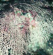
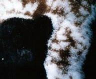
 SOFT CORALS (GORGONIANS)")


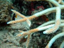
11 APPENDIX A - Identification of basic species (1) FIRE CORAL Millepora alcicornis * Note: Fire coral is one of the first species of coral to show signs of bleaching when water temperatures rise. (2) SOFT CORALS (GORGONIANS) Pteogorgia anceps Pseudopterogorgia sp. Iciligorgia schrammi (3) BRANCHING / PILLAR CORAL Acropora palmata. Porites ssp Acropora cervicornis Note: Elkhorn & Staghorn (Acropora palmata & Acropora cervicornis) are listed as threatened in the US. All photos this page by S. Gore Dendrogyra cylindrus 11


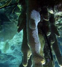
12 (4) BOULDER CORALS APPENDIX A - Identification of basic species (continued) Montastrea cavernosa Montastrea annularis *Note: Boulder star coral ( Montastrea Annularis) is the most common coral found in the BVI. sidereal Siderastrea Porites astreoides *Note: Mustard coral is one of the first species of coral to show signs of bleaching when water temperatures rise. Colpophyllia natans (5) BRAIN CORAL Diporia strigosa All photos this page by S. Gore Diploria Labyrinthiformis 12

")


 FLESHY CORAL (8) CUP")

13 (6) PLATE CORAL APPENDIX A - Identification of basic species (continued) Note: Lettuce coral (agaricia ssp) is one of the first species of coral to show signs of bleaching when water temperatures rise. Agaricia ssp. (7) FLESHY CORAL (8) CUP CORAL Mussa angulosa Mycetophyllia Scolymia ssp Eusamilia fastigiata (9) CALCAREOUS ALGAE Halimeda ssp 13


")
")

14 (10) FLESHY ALGAE APPENDIX A - Identification of basic species (continued) Dictyota Lobophora variegate (11) SPONGES Aplysina ssp (12) SEAGRASSES Thalassia testudinum Syringodium filiforme Halodule wrightii 14


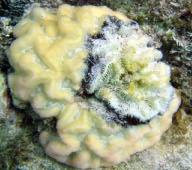
15 APPENDIX B - Identification of live versus recent & old mortality LIVE CORAL RECENT MORTALITY Coral that has recently died will have a fine layer of turf algae growing over the white skeleton. Grooves and ridges are still easily seen. All photos this page by S. Gore 15
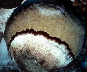
 OLD MORTALITY Limestone skeletons are all that is left of")


16 APPENDIX B - Identification of live versus recent & old mortality (continued) OLD MORTALITY Limestone skeletons are all that is left of old, dead coral. The older the skeleton, the more likely the surface will be eroded to a smooth surface and difficult to identify what species once inhabited it. Fleshy algae often overgrows on the coral skeletons. LIVE CORAL RECENT MORTALITY OLD MORTALITY All photos this page by S. Gore 16

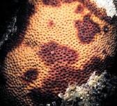
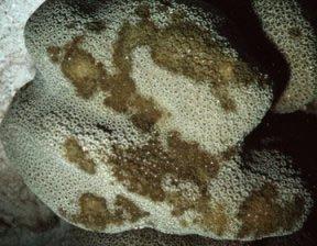


17 APPENDIX C - Identification of coral diseases & predation Black Band Disease Yellow Band Disease Dark Spot Disease Aspergillosis 17


18 Bleaching APPENDIX C - Identification of coral diseases & predation(continued) White Band Disease (Acroporid species only) Photo by A. Bruckner White Plague Parrotfish Biting Damselfish Chimneys Photo by A. Bruckner * All photos this page by S. Gore 18

")


19 APPENDIX D - Identification of bleaching scales In the event of a mass bleaching event, there are two ways in which bleached corals may be monitored. The use of cards developed by CORALWATCH (see Figure 1) or by a scale of 1-5 (sees Figures 3-7). Specific colonies need to be identified and tagged, preferably 20 (five different species) colonies per monitoring station. Corals along the transect line should be used for ease of relocating the colonies. Once the colonies are tagged, one of two methods should be used to monitor the recovery of corals. METHOD 1 CORALWATCH cards may be used to identify the level of bleaching 1 being completely bleached. Place the card next to the coral colony and match to the nearest color. The lightest color as well as the darkest color found within a coral colony should be recorded to track the recovery of corals. Figure 1. CORALWATCH Cards Figure 2. CORALW ATCH cards in use. METHOD 2 The alternative method to monitoring bleached corals uses a scale of 1-5 depicting the different stages of bleaching. This may be the preferred method since the CORALWATCH cards are made for corals of the Pacific Ocean and differ in coloration from the Caribbean corals. The following scale may be used: 1 Fully bleached (white) 2 Mostly bleached (light yellow) 3 Patchy (25-75% white / yellow) 4 Pale 5 Normal All photos this page by S. Gore 19


20 APPENDIX E Bio-indicators 1. BUTTERFLYFISH Stipped Butterflyfish 4-eyed buttrflyfish 2. PARROTFISH Queen Parrtofish Initial Phase Queen Parrtofish Adult male Phase Princess Parrotfish Stoplight Parrotfish Initial Phase * All photos this page by Paul Humann 20


21 APPENDIX E Bio-indicators (cont) Stoplight Parrotfish super Male Stripped Parrotfish 3. COMMERCIAL SPECIES GROUPER Nassau Grouper Tiger Grouper Yellowfin Grouper Red Hind * All photos this page by Paul Humann 21


22 APPENDIX E Bio-indicators (cont) SNAPPER Black Margate Grey Snapper Yellowtail Snapper Schoolmaster Snapper Mahogany Snapper * All photos this page by Paul Humann 22


23 APPENDIX E Bio-indicators (cont) GRUNT French Grunt Bluestriped Grunt White Grunt Ceasar Grunt OTHER COMMERCIAL SPECIES Queen Trigger Blue Runner * All photos this page by Paul Humann 23
")


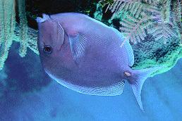
24 APPENDIX E Bio-indicators (cont) Photo by: Paul Humann Bar Jack 4. BLUE TANG Photo by: Paul Humann 4. SPINY URCHINS Photo by: Paul Humann 5. ROCK URCHINS Photo by: Paul Humann 24

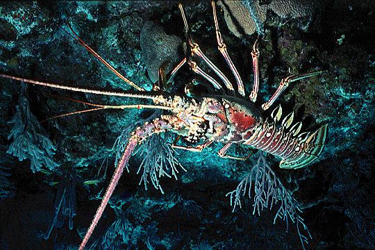
25 APPENDIX E Bio-indicators (cont) 6. CONCH Photo from: 7. SPINY LOBSTER 8. FLAMINGO TONGUES Photo by: Paul Humann Photo by: Paul Humann 25
Biogeographic Assessment of Florida Keys National Marine Sanctuary
 Biogeographic Assessment of Florida Keys National Marine Sanctuary NOAA National Centers for Coastal Ocean Science NOAA Florida Keys National Marine Sanctuary Florida Fish and Wildlife Commission Photos
PEDRO BANK ATLANTIC AND GULF RAPID REEF ASSESSMENT (AGRRA), APRIL 18-26, 2005, SUMMARY REPORT
, APRIL 18-26, 2005, SUMMARY REPORT") PEDRO BANK ATLANTIC AND GULF RAPID REEF ASSESSMENT (AGRRA), APRIL 18-26, 2005, SUMMARY REPORT Prepared by N. Zenny, May 2005 Introduction: The very first coral reef assessment on the Pedro Bank was recently
PEDRO BANK ATLANTIC AND GULF RAPID REEF ASSESSMENT (AGRRA), APRIL 18-26, 2005, SUMMARY REPORT Prepared by N. Zenny, May 2005 Introduction: The very first coral reef assessment on the Pedro Bank was recently
Technical and Financial Proposal
 Technical and Financial Proposal Marine Survey of Montego Bay Marine Park Assessment of Reef Health for Management Recommendations Dayne Buddo Ph.D. Marine Ecologist April 24, 2014. Marine Survey Montego
Quantitative Freshwater Mussel Survey Date Prepared: 11/20/2017
 PARTNERSHIP FOR THE DELAWARE ESTUARY Science Group Quantitative Freshwater Mussel Survey Date Prepared: 11/20/2017 Prepared By: Kurt Cheng Suggested Citation: Cheng, K. 2017. Quantitative Freshwater Mussel
United States Virgin Islands Bleaching Response Sampling Protocols
 United States Virgin Islands Bleaching Response Sampling Protocols USVI Bleaching Response Sampling Protocols... 1 USVI Bleaching Response Sampling Protocols... 3 Outline... 3 Tier I... 3 Tier II... Error!
Field Protocol for Monitoring Coral Reef Fisheries Resources in Belize
 Field Protocol for Monitoring Coral Reef Fisheries Resources in Belize Charles A. Acosta, PhD Wildlife Conservation Society Glover s Reef Marine Research Station P.O. Box 272 Dangriga, Belize and Department
APPENDIX N. CORALS LISTING
 APPENDI N. CORALS LISTING MUNITIONS RESPONSE SITES MRS 02 AND MRS 07 PHASE 2 UNDERWATER RI/FS CULEBRA ISLAND SITE, PUERTO RICO APPENDI N. CORALS LISTING This appendix contains a copy of the NOAA Fisheries
Experimental reestablishment of populations of the long spined sea urchin, Diadema antillarum, on two small patch reefs in the upper Florida Keys
 Principal Investigator Ken Nedimyer 212 Silver Palm Avenue Tavernier, FL 33070 phone (305) 852-4955, fax (305) 852-3500 email, sealife@terranova.net Associate Investigator Martin A. Moe, Jr. 222 Gulfview
Resort and Dive Operation Management, Marine Biology Support, Programmes and Training.
 Helen Sykes & Stuart Gow Mail: PO Box 2558 Government Buildings SUVA, Fiji Islands Tel: (679) 336 3625 or 359 2136 Email: resortsupport@connect.com.fj Resort and Dive Operation Management, Marine Biology
Cluster Analysis for the Puerto Rico Island Region NOAA Fisheries Southeast Regional Office St. Petersburg, FL March 7, 2016 SERO-LAPP
 Cluster Analysis for the Puerto Rico Island Region NOAA Fisheries Southeast Regional Office St. Petersburg, FL March 7, 2016 SERO-LAPP-2016-03 Introduction The U.S. Caribbean is composed of the Commonwealth
Fisheries of the Caribbean, Gulf of Mexico, and South Atlantic; Reef Fish Fishery of Puerto Rico and the U.S. Virgin Islands;
 This document is scheduled to be published in the Federal Register on 06/11/2018 and available online at https://federalregister.gov/d/2018-12420, and on FDsys.gov BILLING CODE: 3510-22-P DEPARTMENT OF
Reef Check Australia. Magnetic Island Season Report 2016
 Reef Check Australia Season Report 16 Reef Check Foundation Ltd. (Australia) www.reefcheckaustralia.org PO Box 134 George St Brisbane QLD 43 This report should be cited as: M. Welch, J. Salmond and J.
Sea urchin density along a depth gradient at Rodney's Rock and Champagne Bay, Dominica
 Sea urchin density along a depth gradient at Rodney's Rock and Champagne Bay, Dominica Michele Felix Cassie Kalinec Julia Lemmon Carl Raetzsch A.J. Vale Andrew Woolley May 28 June 17, 2004 1 Abstract The
BERMUDA GOVERNMENT Ministry of Health, Seniors and Environment Department of Environmental Protection
 BERMUDA GOVERNMENT Ministry of Health, Seniors and Environment Department of Environmental Protection Mailing Address: Botanical Gardens Phone: 441-236-4201 P.O. Box HM 834 169 South Road Fax: 441-236-7582
Reef Watch Guidelines
 Reef Watch Guidelines What is Reef Watch? Reef watch is a simple one-dive-one-survey method to record the health of coral reefs. The method is easily learnt and it is even easier to participate in the
DOMINICA REEF FISH STATUS 2002: An Assessment of the Abundance and Species Composition of Dominican Reef Fishes. ITME Research Reports Number 13
 DOMINICA REEF FISH STATUS 2002: An Assessment of the Abundance and Species Composition of Dominican Reef Fishes. ITME Research Reports Number 13 Fall Semester 2002 Researcher: Dillon M. Green Institute
Citizen Science Based Survey GBR Far North Dive Trip 2016 April 18-26
 Citizen Science Based Survey GBR Far North Dive Trip 2016 April 18-26 Chris Roelfsema Karen Johnson Douglas Stetner Trevor Baerenger Peran Brady May 2016 GBR Far North Citizen Science Trip 5 May 2016 1
DURING ALL ACTIVITIES, MAKE SURE YOU DON T DAMAGE THE REEF OR OTHER MARINE LIFE!
 Fish surveys Long term volunteers can take part in the fish surveys. These surveys are the most complex research we do with volunteers. You have to learn a lot, but in return you will receive a lot of
ACT NOW for the future of our reefs
 Do It Yourself Kit WWW.CORALWATCH.ORG ACT NOW for the future of our reefs Rising water temperatures are a major contributor to mass coral bleaching events. Get involved in CoralWatch to monitor and protect
Volunteer and Internships Programs ECUADOR
 Volunteer and Internships Programs ECUADOR Equilibrio Azul is a non-for profit organization created in 2005 to protect the marine resources of Ecuador. Our mission is to integrate local communities, governmental
OBSERVING CORALS and ALGAE:
 5 OBSERVING CORALS and ALGAE: MANTA TOW, SNORKEL SURVEY, and POINT-INTERCEPT TRANSECT A. Manta Tow Definition A manta tow survey is the observation of an underwater area of good visibility by a snorkeler
EDA. - Divers for the Environment -
 EDA Edition 1 Vol. 1 May 2004 - Divers for the Environment - v EDA is an environmental voluntary organization established in 1995. v Over 200 diving members support EDA. v EDA is now focusing efforts into
Determining coral reef impacts associated with boat anchoring and user activity
 Determining coral reef impacts associated with boat anchoring and user activity Protect Our Reefs Grant Interim Report October 1, 2008 March 31, 2009 Donald C. Behringer 1, Thomas K. Frazer 1, Robert A.
Nature Foundation Marine Park, Reef & Marine Research Assessments Post Hurricane Irma
 Nature Foundation Marine Park, Reef & Marine Research Assessments Post Hurricane Irma Melanie Meijer zu Schlochtern Project Officer Nature Foundation St Maarten 24 November 2017 - ongoing Hurricane Irma
The Population Density of Diadema antillarum at Champagne Reef at Scott s Head Soufriere Marine Reserve
 The Population Density of Diadema antillarum at Champagne Reef at Scott s Head Soufriere Marine Reserve Katy Schumann Dominica 2008 Dr. Lacher Dr. Woolley ABSTRACT: The abundance of the long-spined sea
Environmental Learning Outside the Classroom (ELOC)
") Environmental Learning Outside the Classroom (ELOC) This guidebook provides lesson ideas and activities to get students engaged with outdoor learning. Created by the Virgin Islands Marine Advisory Service
Environmental Learning Outside the Classroom (ELOC) This guidebook provides lesson ideas and activities to get students engaged with outdoor learning. Created by the Virgin Islands Marine Advisory Service
Community-based Coral Reef Monitoring and Management. Report of the Community Reef Watchers Workshop
 Centre for Resource Management and Environmental Studies Funded by Folkestone Marine Reserve, St. James Barbados University of the West Indies Barbados Community-based Coral Reef Monitoring and Management
A Guide to Common Stony Corals of Florida 1
 FA210 1 Joseph A. Henry, Roy P. E. Yanong, Maia P. McGuire, and Joshua T. Patterson 2 An Informational Coral Guide Florida s shallow-water coral reefs have seen large declines in coral cover over the last
John Brewer Reef Sunferries-Townsville
 John Brewer Reef Sunferries-Townsville Latitude: 18 57.364S Longitude: 146 57.375E Date: 31-1-4, 1-2-4 and 24.3.4 Florent Cade 24 SITE DESCRIPTION John Brewer Reef is a mid shelf reef situated approximately
INVESTIGATING VARIATIONS IN CORAL REEF MORPHOLOGY WITH PHOTOMOSAICS AND ANALYSIS OF PERCENT COVER
 INVESTIGATING VARIATIONS IN CORAL REEF MORPHOLOGY WITH PHOTOMOSAICS AND ANALYSIS OF PERCENT COVER by JUSTIN CULMAN A THESIS Presented to the Environmental Studies Program of the University of Oregon In
PORTOMAREA MARINE MONITORING
 CORAL AND FISH/INVERTEBRATE SURVEY by Marjo van den Bulck July 2002 TABLE OF CONTENTS Overview 3 Coral Line Transect Summary 6 Coral Line Chart - % Bottom Cover 7 Coral Line Chart Health 8 Coral Line
Man-O-War Cay. Elbow Cay. Tiloo Cay
 58 FCS FCP Fowl Cay Preserve N * Marsh Harbor Elbow Cay Man-O-War Cay MOWSN MOWSS SR Hopetown * ECN ECM ECSO ECSI 26º 30 N Tiloo Cay Abaco, Bahamas Pelican Cays Land and Sea Park SCB, SCF Sandy Cay LCN
2011 Quick Look Report and Data Summary. December 2011
 Abundance, Distribution and Condition of Acropora Corals, Other Benthic Coral Reef Organisms, and Marine Debris in the Upper Florida Keys National Marine Sanctuary 2011 Quick Look Report and Data Summary
Student Exploration: Coral Reefs 2 Biotic Factors
 Name: Date: Student Exploration: Coral Reefs 2 Biotic Factors [Note to teachers and students: This lesson was designed as a follow-up to the Coral Reefs 1 Abiotic Factors lesson. We recommend doing that
SUMMARY OF CORAL CAY CONSERVATION S REEF CHECK DATA (1997 AND 1998) FROM TURNEFFE ATOLL, BELIZE
 FROM TURNEFFE ATOLL, BELIZE") SUMMARY OF CORAL CAY CONSERVATION S REEF CHECK DATA (1997 AND 1998) FROM TURNEFFE ATOLL, BELIZE - by - Deborah Taylor, Research Assistant Alastair Harborne, Marine Science Co-ordinator December 1999 CORAL
SUMMARY OF CORAL CAY CONSERVATION S REEF CHECK DATA (1997 AND 1998) FROM TURNEFFE ATOLL, BELIZE - by - Deborah Taylor, Research Assistant Alastair Harborne, Marine Science Co-ordinator December 1999 CORAL
DESCRIPTION OF REEF FISH SPAWNING AGGREGATIONS AT MONA ISLAND PUERTO RICO
 DESCRIPTION OF REEF FISH SPAWNING AGGREGATIONS AT MONA ISLAND PUERTO RICO Michelle Schärer, Michael Nemeth, Alfonso Aguilar, Richard Appeldoorn Department of Marine Sciences, University of Puerto Rico,
Annual Report and Plan 2006
 Annual Report and Plan 2006 April D. Ridlon & Bryan Bugler, Marine Biologists 1 2006 Annual Report and Plan Table of Contents 1. Introduction 2. Reef Check Monitoring Project 2.1 Substrates 2.2 Fish 2.3
Abundance, Distribution and Condition of Benthic Coral Reef Organisms in the Upper Florida Keys National Marine Sanctuary
 Abundance, Distribution and Condition of Benthic Coral Reef Organisms in the Upper Florida Keys National Marine Sanctuary 2010 Quick Look Report and Data Summary November 2010 Steven L. Miller, Mark Chiappone
MINNESOTA FRESHWATER MUSSEL SURVEY AND RELOCATION PROTOCOL
 MINNESOTA FRESHWATER MUSSEL SURVEY AND RELOCATION PROTOCOL Minnesota Department of Natural Resources, Division of Ecological and Water Resources U.S. Fish and Wildlife Service, Twin Cities Field Office
Palythoa Abundance and Coverage in Relation to Depth
 Palythoa Abundance and Coverage in Relation to Depth Foisy, Mia 02//208 Foisy, Mia Masternaut Project 02//208 Palythoa Abundance and Coverage in Relation to Depth Abstract: Palythoa abundance and coverage
Southern Leyte Coral Reef Conservation Project (LRCP) LRCP Project Aim. Latest News
 LRCP Project Aim. Latest News") Southern Leyte Coral Reef Conservation Project (LRCP) Monthly Project Update September 2016 Location: Napantao Dive Resort, Napantao, San Francisco, Southern Leyte Project Scientist: Jamie Parker, Darienne
Southern Leyte Coral Reef Conservation Project (LRCP) Monthly Project Update September 2016 Location: Napantao Dive Resort, Napantao, San Francisco, Southern Leyte Project Scientist: Jamie Parker, Darienne
Pre and Post Dredging Coral Health Monitoring
 Pre and Post Dredging Coral Health 11/08/16 Level 31, 12 Creek St Brisbane QLD 4000 Australia 301310-09660-00-EN-REP-0003 www.advisian.com Disclaimer This report has been prepared on behalf of and for
Bioerosion Monitoring Unit (BMU) SOP
 SOP") Bioerosion Monitoring Unit (BMU) SOP I. Purpose II. Construction and predeployment analysis a. Materials b. Assembly procedure III. Deployment directions a. Materials b. Dive preparation c. Dive operation
Bioerosion Monitoring Unit (BMU) SOP I. Purpose II. Construction and predeployment analysis a. Materials b. Assembly procedure III. Deployment directions a. Materials b. Dive preparation c. Dive operation
Curaçao. Curaçao. Bonaire. 1Kalki 2 Westpunt 3 Abou 4 Jeremi 5Lagun 6 Pos Spano 7Piscadera 8 Jan Thiel 9 Oostpunt. 5 km N.
 370 12 0 30 N 19%.. 27%.1 23 21%. 4 30% 19% 5. 24% 6 Aruba Curaçao Bonaire Venezuela N 12 0 N 69 0 W Curaçao 31%. 7 Willemstad 49%.. 8 9 33% 68 0 45 W 1Kalki 2 Westpunt 3 Abou 4 Jeremi 5Lagun 6 Pos Spano
CORALS OF OPPORTUNITY AS A RESTORATION TOOL
 P CORALS OF OPPORTUNITY AS A RESTORATION TOOL Monitoring Manual Prepared by: Anne Chung, Jessica Hintzsche University of Hawaii, Hawaii Coral Reef Initiative 0 Contents Introduction... 2 Monitoring Plan...
CALCIFICATION ACCRETION UNIT (CAU) ASSEMBLY, DEPLOYMENT AND RECOVERY
 ASSEMBLY, DEPLOYMENT AND RECOVERY") CALCIFICATION ACCRETION UNIT (CAU) ASSEMBLY, DEPLOYMENT AND RECOVERY Purpose: CAUs are deployed on the seafloor for up to three years in order to detect changes in net reef accretion. I. CAU Assembly -CAU
CALCIFICATION ACCRETION UNIT (CAU) ASSEMBLY, DEPLOYMENT AND RECOVERY Purpose: CAUs are deployed on the seafloor for up to three years in order to detect changes in net reef accretion. I. CAU Assembly -CAU
Reef Check Australia 2009 Great Barrier Reef Survey Season Report
 Reef Check Australia 2009 Great Barrier Reef Survey Season Report Supported by the Australian Government s Marine and Tropical Sciences Research Facility Project 1.1.2 Condition and trend of the Great
QUALIFICATIONS OF GRADUATES
 NAUI Forensic Diver Course 828-329-9911 scubanaui@gmail.com OVERVIEW This is a continuing education certification course directed towards Certified Scuba Divers with Advanced Training who desire greater
Florida Fish and Wildlife Conservation Commission (FWC)
") Florida Fish and Wildlife Conservation Commission (FWC) Mason Smith Florida Fish and Wildlife Conservation Commission Division of Marine Fisheries Management Version 1 FWC Mission To manage fish and wildlife
Florida Fish and Wildlife Conservation Commission (FWC) Mason Smith Florida Fish and Wildlife Conservation Commission Division of Marine Fisheries Management Version 1 FWC Mission To manage fish and wildlife
Effective multi-agency collaboration improves spatial monitoring and planning in the Florida Keys
 Effective multi-agency collaboration improves spatial monitoring and planning in the Florida Keys Jim Bohnsack Southeast Fisheries Science Center NOAA Fisheries Service Miami, FL 1 The Managed Florida
ATTACHMENT F. Minnesota Department of Natural Resources. Marsh Lake Ecosystem Restoration Project
 ATTACHMENT F Minnesota Department of Natural Resources Marsh Lake Ecosystem Restoration Project Mussel Rescue and Translocation Plan for Pomme de Terre River Restoration (Prepared June, 2016) Attachment
Peninsular Florida Landscape Conservation Cooperative. Priority Resources Marine/Estuarine
 Peninsular Florida Landscape Conservation Cooperative Priority Resources Marine/Estuarine Draft Priority Resources Sub Resources Salt Marsh Mangrove Coral Seagrass Selected Classification systems Cooperative
SCHOOLING BEHAVIOR OF HAEMULON SPP. IN BERMUDA REEFS AND SEAGRASS BEDS
 SCHOOLING BEHAVIOR OF HAEMULON SPP. IN BERMUDA REEFS AND SEAGRASS BEDS Hillary, Department of Biology,, Worcester, MA 01610 (hisullivan@clarku.edu) Abstract Schooling behavior is common among many different
Fisheries in the. US Virgin Islands. Jed Brown Acting Director & Chief of Fisheries USVI Division of Fish and Wildlife St. Croix, US Virgin Islands
 Fisheries in the US Virgin Islands Jed Brown Acting Director & Chief of Fisheries USVI Division of Fish and Wildlife St. Croix, US Virgin Islands US Virgin Islands Territorial waters Shoreline-3 miles
PORTOMAREA MARINE MONITORING
 CORAL AND FISH/INVERTEBRATE SURVEY by Maryke Kolenousky & Marjo van den Bulck April 2002 TABLE OF CONTENTS Overview 3 Coral Line Transect Summary 6 Coral Line Chart - % Bottom Cover 7 Coral Line Chart
Ecological Processes and Coral Reef Recovery in the Florida Keys
 Final 2 October 26 Ecological Processes and Coral Reef Recovery in the Florida Keys Struan R. Smith (Bermuda Biological Station for Research, Inc., St. George s GE, Bermuda) Richard B. Aronson and Thaddeus
Seagrasses of the Virgin Islands
 Seagrasses of the Virgin Islands Seagrasses are flowering plants that live underwater. These marine plants resemble the land species of grasses in that they have long blade-like leaves. Seagrasses grow
Marine Conservation and Research Expedition Training, Examination and Certification Summary
 Marine Conservation and Research Expedition Training, Examination and Certification Summary Introduction This document summarizes the current training schedule and materials being used at the two Marine
Rapid Ecological Assessment of the Reefs of Barbareta Island (Honduras) and Proposed Boundaries for a Marine Reserve
 and Proposed Boundaries for a Marine Reserve") Rapid Ecological Assessment of the Reefs of Barbareta Island (Honduras) and Proposed Boundaries for a Marine Reserve By Ana Fonseca (Lead Consultant) With Odalisca Breedy (Octocorals) Carlos Gamboa (Fish)
Rapid Ecological Assessment of the Reefs of Barbareta Island (Honduras) and Proposed Boundaries for a Marine Reserve By Ana Fonseca (Lead Consultant) With Odalisca Breedy (Octocorals) Carlos Gamboa (Fish)
Coral Reef Activity Book
 Coral Reef Activity Book Coral Reefs for health, for wealth, for life Did you know... Coral reefs can be found in all tropical areas of the world. Corals can also be found in deep cold oceans. Most corals
Vol. 10, Issue Sunday, December 25, 2005 HAWAII'S CORAL REEFS
 Vol. 10, Issue 359 - Sunday, December 25, 2005 HAWAII'S CORAL REEFS Oh, no! A zit! GRETA AEBY, UNIVERSITY OF HAWAII INSTITUTE FOR MARINE BIOLOGY A growth anomaly (tumor) on rice coral. Coral disease is
Fish Aggregations in the Florida Keys
 Fish Aggregations in the Florida Keys Observations of Mutton Snapper on Riley s Hump Date and Station Numbers observed Moon phase 28 May 1 June 1999 1 fish in 3 of the 11 dives Full moon May 30* 31 July
Protect Our Reefs Grant Interim Report (October 1, 2008 March 31, 2009) Principal investigators: Donald C. Behringer and Mark J.
 Principal investigators: Donald C. Behringer and Mark J.") Investigating the role of the spotted spiny lobster (Panulirus guttatus) in the recovery of the long spined sea urchin (Diadema antillarum) on the coral reefs of the Florida Keys Protect Our Reefs Grant
Investigating the role of the spotted spiny lobster (Panulirus guttatus) in the recovery of the long spined sea urchin (Diadema antillarum) on the coral reefs of the Florida Keys Protect Our Reefs Grant
Monitoring the Recruitment of Postlarval Caribbean Spiny Lobster (Panulirus argus) Using Witham Artificial Collectors
 Using Witham Artificial Collectors") Monitoring the Recruitment of Postlarval Caribbean Spiny Lobster (Panulirus argus) Using Witham Artificial Collectors Mark Butler Department of Biological Sciences Old Dominion University Norfolk, Va 23529-0266
Monitoring the Recruitment of Postlarval Caribbean Spiny Lobster (Panulirus argus) Using Witham Artificial Collectors Mark Butler Department of Biological Sciences Old Dominion University Norfolk, Va 23529-0266
Towards Sustainable Multispecies Fisheries in the Florida Coral Reef Ecosystem
 Towards Sustainable Multispecies Fisheries in the Florida Coral Reef Ecosystem Jerald S. Ault University of Miami Rosenstiel School of Marine and Atmospheric Science Southern Florida coral reefs generated
4 Reef Watch Guidelines
 11 4 Reef Watch Guidelines Reef watch is a simple one-dive-one-survey method to record the health of a coral reef. You can easily learn the method and take part in the programme. On your dive or snorkel
CENTER FOR SUBSURFACE SENSING AND IMAGING SYSTEMS
 CENTER FOR SUBSURFACE SENSING AND IMAGING SYSTEMS S4: Coral Reef Monitoring Why Coral Reefs? Roy A. Armstrong UPRM CenSSIS Site Visit April 5, 2006 The Importance of Coral Reefs Coral reefs are highly
OTUMOETAI COLLEGE NCEA MARINE STUDIES LEVEL 2 & 3 (L2 & L3MAST) 2018
 2018") OTUMOETAI COLLEGE MARINE STUDIES LEVEL 2 & 3 (L2 & L3MAST) 2018 MARINE STUDIES L2MAST Course Relationship to the National Vocational Pathways Construction & Infrastructure Course Entry Course Overview
OTUMOETAI COLLEGE MARINE STUDIES LEVEL 2 & 3 (L2 & L3MAST) 2018 MARINE STUDIES L2MAST Course Relationship to the National Vocational Pathways Construction & Infrastructure Course Entry Course Overview
Glover s Reef Marine Reserve Long-term Atoll Monitoring Program (LAMP)
") Glover s Reef Marine Reserve Long-term Atoll Monitoring Program (LAMP) Report for the period July 2004 ust 2011 February 2012 Wildlife Conservation Society, Global Conservation Program, Belize Belize City,
Glover s Reef Marine Reserve Long-term Atoll Monitoring Program (LAMP) Report for the period July 2004 ust 2011 February 2012 Wildlife Conservation Society, Global Conservation Program, Belize Belize City,
Ghost (net) Busters. Ghost Net Retrieval. Time to complete lesson: minutes
 Busters. Ghost Net Retrieval. Time to complete lesson: minutes") Ghost (net) Busters Ghost Net Retrieval Time to complete lesson: 20-30 minutes Purpose of module: This module allows students to simulate the removal of a derelict fishing net from a model coral reef.
Ghost (net) Busters Ghost Net Retrieval Time to complete lesson: 20-30 minutes Purpose of module: This module allows students to simulate the removal of a derelict fishing net from a model coral reef.
St. Croix-Draft Actions and Alternatives.
 [Type the document title] St. Croix-Draft Actions and Alternatives. Scoping Meetings April 2014 Table of Contents List of Tables... 2 List of Figures... 2 Action 1. Identify Fishery Management Units (FMUs)
Oceanic Society Reef Research Team: Nicole Crane, Avigdor Abelson, Peter Nelson, Giacomo Bernardi, Michelle Paddack, Kate Crosman
 The coral reef of Tamil (Yap, FSM): Preliminary ecological assessment of reef state and fish assemblages, and potential of conservation for sustainable use Report compiled by vigdor belson, Peter Nelson
A PHYSICAL AND BIOLOGICAL SURVEY OF THE MID-REACH MITIGATION REEF SET NUMBER 1
 A PHYSICAL AND BIOLOGICAL SURVEY OF THE MID-REACH MITIGATION REEF SET NUMBER 1 John M. Hearin, Ph.D., P.E. 1 ; Geoff Swain, Ph.D. 2 ; Robert Weaver, Ph.D., P.E. 2 ; Kelli Z. Hunsucker, Ph.D. 2 ; Caglar
Status of Curaçao s Reefs
 References can be found in BioNews Issue 4 Map of Curaçao. Image credit: DCNA The island of Curaçao is almost entirely surrounded by narrow fringing reef that covers an estimated area of 7.85 km2 (Vermeij,
Keywords: marine habitat recovery, derelict fishing gear
 Marine habitat recovery after derelict fishing net removal. Jeff June*, Kyle Antonelis, Natural Resources Consultants, Inc. Seattle, WA. *Corresponding author: jjune@nrccorp.com Keywords: marine habitat
TOBAGO COASTAL ECOSYSTEMS MAPPING PROJECT RESULTS OF COMMUNITY AND SCIENTIFIC WORK MARCH DECEMBER Prepared for -
 TOBAGO COASTAL ECOSYSTEMS MAPPING PROJECT RESULTS OF COMMUNITY AND SCIENTIFIC WORK MARCH DECEMBER 2007 - Prepared for - Integrated Watershed and Coastal Area Management in Small Island Developing States
SPECIES RICHNESS IN THREE OCEANFLOOR HABITATS IN BERMUDA BAYS
 SPECIES RICHNESS IN THREE OCEANFLOOR HABITATS IN BERMUDA BAYS Madeline Department of Biology,, Worcester, MA 01610 USA (madcole@clarku.edu) Abstract Species richness of fish was compared between sand,
Lat: Long: Captain: Crew: Topside conditions: Cloud cover (%): Wind Spd & Dir: Wave height (ft):
: Wind Spd & Dir: Wave height (ft):") Great Goliath Grouper Count: Survey Data Site name: Date: Dive# of day Lat: Long: Captain: Crew: Diver names: Topside conditions: Cloud cover (%): Wind Spd & Dir: Wave height (ft): Site type (check one):
Great Goliath Grouper Count: Survey Data Site name: Date: Dive# of day Lat: Long: Captain: Crew: Diver names: Topside conditions: Cloud cover (%): Wind Spd & Dir: Wave height (ft): Site type (check one):
Determining Coral Reef Impacts Associated with Boat Anchoring and User Activity in Southeast Florida
 Determining Coral Reef Impacts Associated with Boat Anchoring and User Activity in Southeast Florida Southeast Florida Coral Reef Initiative Fishing, Diving, and Other Uses Local Action Strategy Project
Seagrass surveys must be conducted between the dates of April 1 st and October 31 st with the following exceptions:
 Florida Fish and Wildlife Conservation Commission (FWC) Recommended Survey Protocols for Estuarine and Marine Submerged Aquatic Vegetation (SAV) related to Permitting Applications 12/14/2011 DRAFT 1) Survey
Focus on New Sites for Caves and Reefs Issues Identified. Dr. Leyla Knittweis-Mifsud Department of Biology, Faculty of Science University of Malta
 Focus on New Sites for Caves and Reefs Issues Identified Dr. Leyla Knittweis-Mifsud Department of Biology, Faculty of Science University of Malta Presentation Overview Areas of conservation potential within
Survey Technique for Underwater Digital Photography with Integrated GPS Location Data
 Survey Technique for Underwater Digital Photography with Integrated GPS Location Data Tim Siwiec: United States Environmental Protection Agency Abstract This survey technique is an inexpensive method of
Annual Catch Limits and Accountability Measures
 Annual Catch Limits and Accountability Measures in the U.S. Caribbean (including Puerto Rico, St. Croix, St. Thomas, and St. John) / I,, I t Striped Parrotfish (courtesy of reefguide.org) Queen Conch (courtesy
THE SEAGRASS LANDSCAPE OF BUNDAS MARINE PROTECTED AREA, BARANGAY BAGUMBAYAN, LUPON, DAVAO ORIENTAL, PHILIPPINES
 THE SEAGRASS LANDSCAPE OF BUNDAS MARINE PROTECTED AREA, BARANGAY BAGUMBAYAN, LUPON, DAVAO ORIENTAL, PHILIPPINES Presented by: Cirilo O. Ybaňez Jr. 1, Kris Vallerie A. Oñate 2 Davao Oriental of State College
Curacao Reef Acoustics Expedition Ed Sobey, PhD.
 Flag report Background Climate change and environmental pressure are having drastic impact on coral reefs worldwide. Thermal and ph stress combine with infections to kill this, the most diverse and productive
Night Diving. Why night dive? The preparations. Keeping track of where you are. Handling equipment
 Night Diving Why night dive? The preparations Keeping track of where you are Handling equipment Night Diving The preparations Keeping track of where you are Handling equipment Night Diving Why night dive:
Freshwater Mussel Tagging, Release, and Monitoring Date Prepared: 11/20/2017
 PARTNERSHIP FOR THE DELAWARE ESTUARY Science Group Freshwater Mussel Tagging, Release, and Monitoring Date Prepared: 11/20/2017 Prepared By: Kurt Cheng Suggested Citation: Cheng, K. 2017. Freshwater Mussel
MBARA Diver s Reef Survey Form Updated 4 April 2010
 MBARA Diver s Reef Survey Form Updated 4 April 2010 Reef Site Name: MB 104 Unnamed Reef Position Readings: GPS Manufacturer & model: Garmin 188C N Lat.: 29 43.487 W Lon.: 85 41.562 Sonar Depth: Survey
Rising Tide Oyster Company 2.0 Acre Bellamy Site Marine Aquaculture License Application
 Rising Tide Oyster Company 2.0 Acre Bellamy Site Marine Aquaculture License Application Joshua and Jessica Carloni 264 Swain Road Barrington, N.H. 03825 Summary This is an amendment to our existing license
Spawning Aggregation Evaluation. Utila January February 2009
 Spawning Aggregation Evaluation Utila January February 2009 Location Selection Selection considered fishermen and logistics Location 1: Joshua Swash Location 2: The Elbow The Elbow cancelled after January
Seagrass Surveys in Kampot
 Coastal Annual Forum 23 rd October 2014 Sihanoukville, Cambodia Seagrass Surveys in Kampot Presentation by Louis Bourne INTERNATIONAL UNION FOR CONSERVATION OF NATURE Presentation Overview Location and
Sherwood Forest Flag Expedition
 Sherwood Forest Flag Expedition May 10 th to 20 th 2005 Flag #53 Introduction: Since its inclusion in the nation s largest permanent marine reserve as part of the Florida Keys National Marine Sanctuary,
Summary of Research within Lamlash Bay No-Take Zone - Science report for COAST July
 Summary of Research within Lamlash Bay No-Take Zone - Science report for COAST July 2013 - *Picture of a spider crab (Macropodia spp) inside a plumose anemone. Taken within Lamlash Bay No-Take Zone by
The Wide Spread Negative Effects of Exposure to Excess Nutrients for Coral Reefs
 The Wide Spread Negative Effects of Exposure to Excess Nutrients for Coral Reefs Introduction: The majority of the Earth we live on is underwater, yet we know so little about life below the surface. It
Domain (island) wide estimates of mutton snapper (Lutjanus analis) abundance for three US Caribbean Islands based on habitat-derived densities
 wide estimates of mutton snapper (Lutjanus analis) abundance for three US Caribbean Islands based on habitat-derived densities") Domain (island) wide estimates of mutton snapper (Lutjanus analis) abundance for three US Caribbean Islands based on habitat-derived densities SEDAR REPORT # SEDAR14-AW2 Prepared May 2007 by Christopher
Domain (island) wide estimates of mutton snapper (Lutjanus analis) abundance for three US Caribbean Islands based on habitat-derived densities SEDAR REPORT # SEDAR14-AW2 Prepared May 2007 by Christopher
(679) Dive Line (679) FAX (679)
 Dive Line (679) FAX (679)") (679) 867 7513 Dive Line (679) 888 1111 FAX (679) 888-1333 www.nakiafiji.com DESCRIPTION OF TOURS AND COURSES October 2009 All prices are in US dollars (US$) and do not include local taxes of 15% Thank
(679) 867 7513 Dive Line (679) 888 1111 FAX (679) 888-1333 www.nakiafiji.com DESCRIPTION OF TOURS AND COURSES October 2009 All prices are in US dollars (US$) and do not include local taxes of 15% Thank
INTRACOASTAL WATERWAY DEEPENING BROWARD COUNTY, FLORIDA HARD CORAL RELOCATION SUMMARY REPORT
 INTRACOASTAL WATERWAY DEEPENING BROWARD COUNTY, FLORIDA 17th Street Bridge to 4,000 Feet North of the Las Olas Blvd. Bridge HARD CORAL RELOCATION SUMMARY REPORT Prepared for: Prepared by: 204 N. Dixie
The State of Coral Reef Ecosystems of the Flower Garden Banks, Stetson Bank, and Other Banks in the Northwestern Gulf of Mexico
 The State of Coral Reef Ecosystems of the, Stetson Bank, and Other Banks in the Northwestern Gulf of Mexico Emma L. Hickerson 1, G.P. Schmahl 1 INTRODUCTION AND SETTING The East and West (EFGB and WFGB)
SCUBA. The award winning health & wellbeing experience St Lucia, West Indies
 SCUBA G i v e u s y o u r b o d y f o r a w e e k a n d w e w i l l g i v e y o u b a c k y o u r m i n d The award winning health & wellbeing experience St Lucia, West Indies Beach Dives Daytime beach
De Rust Grass Carp Stocking Policy
 De Rust Grass Carp Farm Tel: 023 616 2444 Fax: Natli 0865447505 Email: info@outdoorarena.co.za Web: www.grasscarp.co.za PO Box 15, Bonnievale, 6730 De Rust Grass Carp Stocking Policy All grass carp produced