AHO s experience on HD bathymetric ENCs
|
|
|
- Frank Jones
- 5 years ago
- Views:
Transcription

1 AHO s experience on HD bathymetric ENCs ENCWG3 Wollongong April 2018 Alvaro Sanchez DD Charting Quality Assurance, Standards and Specifications Australian Hydrographic Office
2 Background 2016 As part of the AHO s ENC first production strategy, AHO staff commenced attending an IMO approved generic ECDIS training course (around 40 people so far). One of the main concerns from mariners was the lack of bathymetric detail inside dredged areas The AHO decided to investigate the possibility of producing high density bathymetric ENC products using current standards. The ports of Cairns (larger cruise ships) and Townsville (one of the first ports in Australia to use PPUs) were selected as the test areas to prove the concept. The AHO s regional production manager and one of the production supervisors organised meetings with the main stakeholders in both ports (Harbourmaster; pilots; port surveyors)
3 Technical considerations Areas with different re-surveying frequencies were split into different AU6 ENC cells. M_COVR CATCOV=1 limits negotiated among stakeholders and submitted by the harbourmasters Surveys must overshoot the M_COVR boundary by at least 20 meters. Surveys must provide full sea bottom coverage and be within ZOC A1 horizontal and vertical accuracy. The AHO decided that a cut and replace approach was the most efficient production strategy. The automation in the production of contours and depth areas was key to support a short turn around production.
4
5 KEY POINTS Asses the need of HD bencs on a port by port basis (e.g. supported by a business case). Once a decision to proceed has been made it should be followed up by a meeting involving the HO s regional production manager, the port s Harbourmaster, a senior pilot, and port surveyors. The area covered MUST be as small as possible in order to safely operate the largest ship calling the port. It must focus on restricted waters (very narrow passages, strong currents, sharp turns, etc). The size of the area directly affects production times and ENC size. One meter contours are AHO s preferred option. It was selected as the most realistic contour spacing to be offered to mariners based on the uncertainty of all the different measurements involved in the determination of the final depth figures (tidal models, depth (e.g. +/- 0.5m + 1%d for an A1 survey). We also consider uncertainties coming from the measurement of the draught of the ship itself (especially when it is also affected by squatting). For bencs covering dredged channels, the use of an intermediate contour equal to the design depth of the channel (e.g. 11.7m) is strongly recommended as it normally reflects the maximum draught (plus tide, less port s UKC requirements) of vessels able to enter the port. Soundings, spaced at 50/100m depending on the width of the channel, were also requested by mariners. They are considered important to support the one meter contours utilising the safety depth setting in ECDIS. The port survey areas must overshoot the benc extents and must be supplied to the HO in full (there s no such a thing as merging old and new one meter contours). Harbourmasters and port surveyors must commit to this process in order to maintain consistency on their deliverable making the HO s internal processes repeatable. Let the Harbourmaster, local pilots and port surveyors come up with the extents of the benc cells. By doing that they are committing to the project. Port stakeholders are quick to ask HO s for more contours over large areas but they seem not to be aware of the fact that those areas must be re surveyed periodically and that in the end it will affect their resources. From our experience, making them accountable for one of the key moving parts of the project ends up resulting on very sensible product extents. We intend to produce our AU6 ENC based on survey extents created by the Ports.
6 Port surveyors and HO s tides and bathymetric data validation representatives must agree, beforehand, on file formats, metadata and LAT adjustment values in order to speed up the registration, processing and validation of the incoming data as much as possible. Ideally, the updated ENC cell must be released to the RENC in not more than 7 working days since the receipt of the new bathy by the HO. Maximum ENC cell size is still 5MB so if an area becomes too large it must be split in more than one product. The survey must be processed as one entity. A surface will be created and the depth contours (DEPCNT) and depth areas (DEPARE) will be auto generated. The result file will be cropped using the official ENC extents ; all the previous contours and areas will be deleted from the AU6 cell and replaced with the new ones. Soundings will be also auto generated by the software. Any other non-bathymetric data overlapping the area will be included in the AU6 (e.g. navaids, wrecks, etc) High resolution coastline will be retained at the AU5 level and the AU6 will run very close to it without duplicating the data. This will avoid topology issues while trying to join auto generated contours and depth areas against other non-bathymetric features. On the AU5, a M_CSCL object with the same scale than the AU6 (extending up to 100m from the seawall) can be added to avoid the over scale warning pattern display on ECDIS. This provides a seamless display.


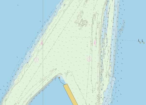
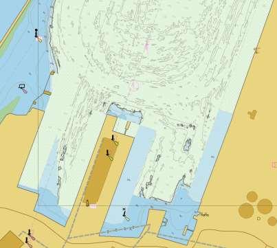
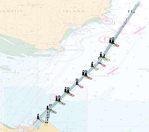
7 AU5 ENC showing DRGARE and no bathy AU5 ENC with overlapping AU6 (benc)
8
9
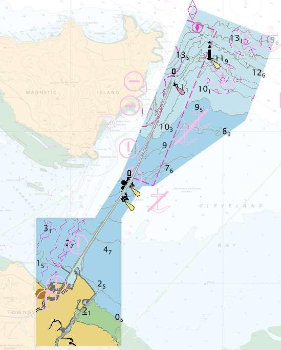
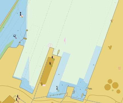
10 Townsville AU5 Townsville AU6 coverage
11
12 QUESTIONS?
Paper for consideration by ENC Working Group. Use of AU6 ENC cells as an option for Bathymetric ENCs (benc)
") Paper for consideration by ENC Working Group Use of AU6 ENC cells as an option for Bathymetric ENCs (benc) Submitted by: Alvaro Sanchez (AHS) Executive Summary: Compilation of high density bathymetric
Paper for consideration by ENC Working Group Use of AU6 ENC cells as an option for Bathymetric ENCs (benc) Submitted by: Alvaro Sanchez (AHS) Executive Summary: Compilation of high density bathymetric
DUKC Chart Overlay. Presentation to IHO TWL and DQ Working Groups Wollongong, March 2014
 DUKC Chart Overlay Presentation to IHO TWL and DQ Working Groups Wollongong, March 2014 Outline Who is OMC? DUKC description & methodology. DUKC Chart Overlay concept. Chart Overlay application example.
Paper for Consideration by HSSC8 Development of an Additional Bathymetry Layer standard based on S-57/S-52
 Paper for Consideration by HSSC8 Development of an Additional Bathymetry Layer standard based on S-57/S-52 Submitted by: CIRM, Germany, USA (NOAA) Executive Summary: Proposal for the standardization of
PORTS AUSTRALIA. PRINCIPLES FOR GATHERING AND PROCESSING HYDROGRAPHIC INFORMATION IN AUSTRALIAN PORTS (Version 1.5 November 2012)
") PORTS AUSTRALIA PRINCIPLES FOR GATHERING AND PROCESSING HYDROGRAPHIC INFORMATION IN AUSTRALIAN PORTS (Version 1.5 November 2012) PREFACE These Principles have been prepared by the Hydrographic Surveyors
PORTS AUSTRALIA PRINCIPLES FOR GATHERING AND PROCESSING HYDROGRAPHIC INFORMATION IN AUSTRALIAN PORTS (Version 1.5 November 2012) PREFACE These Principles have been prepared by the Hydrographic Surveyors
EMPA 2017 How can the S-102 Bathymetric Surface Product improve safety in navigation and pilotage?
 EMPA 2017 How can the S-102 Bathymetric Surface Product improve safety in navigation and pilotage? Operated by the Norwegian Mapping Authority, Hydrographic Service FREEDOM TO CHOOSE Content What is the
S-44 edition 5 The IHO s New Standard For Hydrographic Surveys Chris Howlett Head of Seabed Data Centre United Kingdom Hydrographic Office
 S-44 edition 5 The IHO s New Standard For Hydrographic Surveys Chris Howlett Head of Seabed Data Centre United Kingdom Hydrographic Office Chairman of IHO Working Group that created S-44 edition 5 S-44
THE CHALLENGES OF A LARGE-AREA BATHYMETRIC SURVEY
 THE CHALLENGES OF A LARGE-AREA BATHYMETRIC SURVEY Agenda: - Introduction - Tender - Project Planning - Survey - Processing - Delivery - Conclusion 2 Introduction We know less of the oceans at our feet,
Utilizing Vessel Based Mobile LiDAR & Bathymetry Survey Techniques for Survey of Four Southern California Breakwaters
 Utilizing Vessel Based Mobile LiDAR & Bathymetry Survey Techniques for Survey of Four Southern California Breakwaters Western Dredging Association: Pacific Chapter September 2012 Insert: Pipe Location
HYDROGRAPHIC SECTION QATAR NATIONAL REPORT TO THE 4 TH ROPME SEA AREA HYDROGRAPHIC COMMISSION MEETING
 HYDROGRAPHIC SECTION QATAR NATIONAL REPORT TO THE 4 TH ROPME SEA AREA HYDROGRAPHIC COMMISSION MEETING MUSCAT, OMAN 21 23 MARCH 2011 1. Hydrographic Office / Service This report summarizes the activities
1 st Tidal and Water Level Working Group Meeting DHN, Niteroi, Brazil 31/03/09 02/04/09 Vertical Offshore Reference Framework (VORF) Chris Jones
 Chris Jones") 1 st Tidal and Water Level Working Group Meeting DHN, Niteroi, Brazil 31/03/09 02/04/09 Vertical Offshore Reference Framework (VORF) Chris Jones United Kingdom Hydrographic Office Presentation Structure
1 st Tidal and Water Level Working Group Meeting DHN, Niteroi, Brazil 31/03/09 02/04/09 Vertical Offshore Reference Framework (VORF) Chris Jones United Kingdom Hydrographic Office Presentation Structure
ICES Guidelines for Multibeam Echosounder Data (Compiled September 2006)
") ICES Guidelines for Multibeam Echosounder Data (Compiled September 2006) If you are considering producing a hydrographic survey please read the following information first. Your survey could be used to
ICES Guidelines for Multibeam Echosounder Data (Compiled September 2006) If you are considering producing a hydrographic survey please read the following information first. Your survey could be used to
Underkeel Clearance Management Systems. Captain Jonathon Pearce Senior Pilotage Advisor
 Underkeel Clearance Management Systems Captain Jonathon Pearce Senior Pilotage Advisor Underkeel Clearance Risk Management (UKCM) The management of the touch bottom or grounding hazard Risk = Frequency
NEED FOR SUPPLEMENTAL BATHYMETRIC SURVEY DATA COLLECTION
 305 West Grand Avenue, Suite 300 Montvale, New Jersey 07645 Phone 201.930.9890 Fax 201.930.9805 www.anchorqea.com M EMORANDUM To: Caroline Kwan and Nica Klaber U.S. Environmental Protection Agency Region
V Complying with IHO S-52/S-63/S-64
 Model FEA-2107/2807 V.06.50 Complying with IHO S-52/S-63/S-64 The software has been upgraded to V.06.50 in accordance with the IHO standards. IHO S-52 Ed. 6.1.1 Specifications for Chart Contents and Display
Developing a Method to Validate the Navigational Bathymetric Database
 Developing a Method to Validate the Navigational Bathymetric Database Katrina Wyllie 1*, Marcus Cole 2, Grant Froelich 1, Matthew Wilson 1, Kurt Nelson 2, CAPT Richard Brennan, NOAA 1, and Travis Newman
This report summarizes the activities of Hydrographic Unit of Qatar carried out since the 6 th RSAHC meeting in February 2015.
 1. Hydrographic Unit This report summarizes the activities of Hydrographic Unit of Qatar carried out since the 6 th RSAHC meeting in February 2015. The latest update for the IHO Yearbook is the following:
A PRACTICAL APPROACH TO QUALITY CONTROL AND QUALITY ANALYSIS OF DEPTH DATA
 A PRACTICAL APPROACH TO QUALITY CONTROL AND QUALITY ANALYSIS OF DEPTH DATA ABSTRACT Ulf Olsson, Mats Ericson, Stigbjörn Nilsson, Hans Öiås Hydrographic Office, Swedish Maritime Administration, Sweden Quality
FULL SCALE MEASUREMENT OF DYNAMIC SHIP MOTIONS AND SQUAT
 FULL SCALE MEASUREMENT OF DYNAMIC SHIP MOTIONS AND SQUAT Mr. Gary Rolph Chief Hydrographic Surveyor Port of Brisbane Corporation Mr. Peter Rumball Surveyor Port of Brisbane Corporation Dr. Terry O'Brien
DISCUSSION PAPER: NEW GENERALISATION POLICY FOR SMALL SCALE ADMIRALTY CHARTS.
 DISCUSSION PAPER: NEW GENERALISATION POLICY FOR SMALL SCALE ADMIRALTY CHARTS. PREFACE. Throughout this paper we will be making reference to largest scale, second scale, third scale coverage on an SNC (Standard
Wheatstone Marine Operations - Pilotage - Passage Plan - Onslow Port Limit to WMT
 Wheatstone Marine Operations - Pilotage - Passage Plan - Onslow Port Limit to WMT 1.0 INTRODUCTION Vessels entering the Port of Ashburton require an approved berth to berth passage plan in accordance with
HELSINKI COMMISSION HELCOM SAFE NAV 4/2014 Group of Experts on Safety of Navigation Fourth Meeting Helsinki, Finland, 4 February 2014
 HELSINKI COMMISSION HELCOM SAFE NAV 4/2014 Group of Experts on Safety of Navigation Fourth Meeting Helsinki, Finland, 4 February 2014 Agenda Item 3 Accidents and ship traffic in the Baltic Sea Document
Nautical sub-committee
 Nautical sub-committee Accomplishments, latest work and developments Capt. Pantelis Patsoulis Nautical sub-committee INTERTANKO s most recently established subcommittee. Established from parent committee
Bathymetry User Needs and Challenges in Australia and New Zealand
 Bathymetry User Needs and Challenges in Australia and New Zealand Nathan Quadros nquadros@crcsi.com.au Shallow Water Survey February 212 Background Recent significant investment in Bathymetric LiDAR acquisition
ROUTEING MEASURES OTHER THAN TRAFFIC SEPARATION SCHEMES
 E 4 ALBERT EMBANKMENT LONDON SE1 7SR Telephone: +44 (0)20 7735 7611 Fax: +44 (0)20 7587 3210 SN.1/Circ.317 4 December 2012 ROUTEING MEASURES OTHER THAN TRAFFIC SEPARATION SCHEMES 1 The Maritime Safety
Appendix 2: Presentation Library for Inland ECDIS TABLE OF CONTENTS
 Appendix 2: Presentation Library for Inland ECDIS TABLE OF CONTENTS 1. Lookup Tables... 2 2. Conditional Symbology Procedures... 2 2.1. Top marks... 2 2.2. Daymars... 2 2.3. Restricted areas... 2 2.4.
SAFETY OF NAVIGATION OPERATING ANOMALIES IDENTIFIED WITHIN ECDIS
 E 4 ALBERT EMBANKMENT LONDON SE1 7SR Telephone: +44 (0)20 7735 7611 Fax: +44 (0)20 7587 3210 SN.1/Circ.312 9 July 2012 SAFETY OF NAVIGATION OPERATING ANOMALIES IDENTIFIED WITHIN ECDIS 1 The Sub-Committee
INTERNATIONAL HYDROGRAPHIC SURVEY STANDARDS
 INTERNATIONAL HYDROGRAPHIC SURVEY STANDARDS by Gerald B. MILLS 1 I. Background The International Hydrographic Organization (IHO) traces its origin to the establishment of the International Hydrographic
INTERNATIONAL HYDROGRAPHIC ORGANIZATION
 INTERNATIONAL HYDROGRAPHIC ORGANIZATION S-67 MARINERS GUIDE TO ACCURACY OF ELECTRONIC NAVIGATIONAL CHARTS (ENC) Edition 0.5 July 2017 Copyright International Hydrographic Organization 2017 This work is
SAFETY NOTICE ABOUT THE RELIABLE OPERATION OF ECDIS
 IHB File No. S3/8157 CIRCULAR LETTER 33/2012 14 March 2012 THIS LETTER CONTAINS IMPORTANT INFORMATION ABOUT SAFETY OF NAVIGATION SAFETY NOTICE ABOUT THE RELIABLE OPERATION OF ECDIS Reference: a) IHB Circular
CLARIFICATION PAPER DREDGED MATERIAL VOLUME ESTIMATES
 CLARIFICATION PAPER DREDGED MATERIAL VOLUME ESTIMATES Prepared by Hiram Arden (Corps of Engineers), David Fox (Corps of Engineers) and Ted Benson (DNR) for the PSDDA agencies. INTRODUCTION In a PSDDA sediment
Outcome of the discussion with other HSSC WG on contribution to the MSP MSP development work
 NIPWG 4-43.1 Submitted by: Executive Summary: Paper for Consideration by NIPWG IMO e-navigation Hydrographic Services Related Documents: HSSC7 (action item 7/35) Related Projects: IMO e-navigation NIPWG
Uncertainty Estimates in Satellite Derived Bathymetry
 Uncertainty Estimates in Satellite Derived Bathymetry Richard Flemmings, TCarta #chcnsc2018 Introduction and Overview 1. TCarta 2. Satellite Derived Bathymetry Overview 3. Satellite Derived Bathymetry
Activities of KHOA on creation of S-10X test data sets and S-100 sea trial
 Activities of KHOA on creation of S-10X test data sets and S-100 sea trial Submitted by: Executive Summary: Related Documents: Related Projects: Republic Of Korea (KHOA) KHOA has been conducting a research
BOTTOM MAPPING WITH EM1002 /EM300 /TOPAS Calibration of the Simrad EM300 and EM1002 Multibeam Echo Sounders in the Langryggene calibration area.
 BOTTOM MAPPING WITH EM1002 /EM300 /TOPAS Calibration of the Simrad EM300 and EM1002 Multibeam Echo Sounders in the Langryggene calibration area. by Igor Kazantsev Haflidi Haflidason Asgeir Steinsland Introduction
MARINE NOTICE MARINE NOTICE. Marine Notice 7/2012. Guidance on ECDIS for ships calling at Australian ports 7/2012
 MARINE NOTICE MARINE 7/2012 NOTICE Marine Notice 7/2012 Guidance on ECDIS for ships calling at Australian ports This notice aims to clarify some of the emerging issues relating to the carriage requirements
THE SYLLABUS FOR WRITTEN EXAMINATION PILOT'S FOURTH CLASS LICENCE (TEES AND HARTLEPOOL) AND
 AND") PD TEESPORT CONSERVANCY DIVISION HARBOUR MASTER'S OFFICE THE SYLLABUS FOR WRITTEN EXAMINATION IN RESPECT OF A PILOT'S FOURTH CLASS LICENCE (TEES AND HARTLEPOOL) AND PILOTAGE EXEMPTION CERTIFICATE (Issued
PD TEESPORT CONSERVANCY DIVISION HARBOUR MASTER'S OFFICE THE SYLLABUS FOR WRITTEN EXAMINATION IN RESPECT OF A PILOT'S FOURTH CLASS LICENCE (TEES AND HARTLEPOOL) AND PILOTAGE EXEMPTION CERTIFICATE (Issued
TIME VARYING OBJECTS IN ECDIS Today, tomorrow and soon after
 TIME VARYING OBJECTS IN ECDIS Today, tomorrow and soon after by Bohdan PILLICH 1 Abstract ECDIS is about to become a commercial reality. However, the full potential of the system is not likely to be realised
14/10/2013' Bathymetric Survey. egm502 seafloor mapping
 egm502 seafloor mapping lecture 10 single-beam echo-sounders Bathymetric Survey Bathymetry is the measurement of water depths - bathymetry is the underwater equivalent of terrestrial topography. A transect
Gorgon - Pilotage - Passage Plan - PBG to Gorgon Marine Terminal - Alternative Route
 1.0 Introduction This work instruction outlines the passage plan to be used by vessels transiting from the Port of Barrow Island PBG to the Gorgon Marine Terminal, via the alternative route, with a Pilot
Geospatial Positioning Accuracy Standards Part 5: Standards for Nautical Charting Hydrographic Surveys - Public Review Draft
 Appendix B FGDC Hydrographic Accuracy Standard Geospatial Positioning Accuracy Standards Part 5: Standards for Nautical Charting Hydrographic Surveys - Public Review Draft Subcommittee on Marine and Coastal
Chart Features Maritime maps and Admiralty charts have these features:
 Introduction to Charts A chart or map of the area is an important safety item to carry on board. It allows the Master to obtain knowledge of the area to be travelled, and indicates the navigable channels
Gorgon Pilotage Passage Plan - PBG to Gorgon Marine Terminal Primary Route
 Gorgon Pilotage Passage Plan - PBG to Gorgon Marine Terminal Primary Route 1.0 Introduction Vessels transiting within port limits from the Barrow Island Outer Pilot Boarding Ground (PBG) to the Gorgon
Gorgon - Pilotage - Passage Plan Materials Offloading Facility (MOF) to PBG
 to PBG") Gorgon - Pilotage - Passage Plan Materials Offloading Facility (MOF) to PBG 1.0 Introduction Vessels transiting within port limits from the Materials Offloading Facility (MOF) to the Barrow Island Pilot
Gorgon - Pilotage - Passage Plan Materials Offloading Facility (MOF) to PBG 1.0 Introduction Vessels transiting within port limits from the Materials Offloading Facility (MOF) to the Barrow Island Pilot
Hydrographic Surveying at The Port of London
 Hydrographic Surveying at The Port of London John Dillon-Leetch Port and Terminal Technology 2009 14 th October, Antwerp Overview Introduction Surveying the Thames Navigational Charting High Resolution
Journey of a Sounding: Application of NOAA Soundings and Features to Navigation Products
 Journey of a Sounding: Application of NOAA Soundings and Features to Navigation Products Crescent Moegling, Peter Holmberg NOAA, Pacific Hydrographic Branch Seattle, WA Introduction: From the moment a
Tutorial for the. Total Vertical Uncertainty Analysis Tool in NaviModel3
 Tutorial for the Total Vertical Uncertainty Analysis Tool in NaviModel3 May, 2011 1. Introduction The Total Vertical Uncertainty Analysis Tool in NaviModel3 has been designed to facilitate a determination
Orkney and Shetland Islands (2016)
") Clyde Cruising Club Amendments to Sailing Directions Clyde Cruising Club Publications Ltd. Orkney and Shetland Islands (2016) This PDF file contains all the amendments for the above volume of the CCC Sailing
Clyde Cruising Club Amendments to Sailing Directions Clyde Cruising Club Publications Ltd. Orkney and Shetland Islands (2016) This PDF file contains all the amendments for the above volume of the CCC Sailing
High Precision Hydrography in Canada, the ST. Lawrence River Channel, HD Bathymetry, Production, Distribution and Updating
 High Precision Hydrography in Canada, the ST. Lawrence River Channel, HD Bathymetry, Production, Distribution and Updating Marc Journault Canada CHS, Louis Maltais Canada CHS, and Richard Sanfaçon Canada
Compact Light Weight RC Boat for Hydrographic Surveys on Dams, Creeks, Rivers, storm water retention pits and other waterways.
 Accura Hydrographic RC Survey Boat Compact Light Weight RC Boat for Hydrographic Surveys on Dams, Creeks, Rivers, storm water retention pits and other waterways. Utilises Sounder & Transducer from CEE
ECDIS Chart Layers. And. Their Navigational Impact
 ECDIS Chart Layers And Their Navigational Impact 1 ONE COMPANY ONE PARTNER To the benefit of all: Added value from integrated products and services IS Value Chain Partner for the maritime industry 2 SYSTEM
Incident Report. Close Quarters Pegasus II & Distraction. 26 April 2006 Class B
 Incident Report Close Quarters Pegasus II & Distraction 26 April 2006 Class B NARRATIVE Pegasus II (See Photograph 1 Pegasus II) is a 15.46 metre commercial fishing vessel with a gross tonnage of 40. She
Evaluation of the Klein HydroChart 3500 Interferometric Bathymetry Sonar for NOAA Sea Floor Mapping
 Evaluation of the Klein HydroChart 3500 Interferometric Bathymetry Sonar for NOAA Sea Floor Mapping Yuhui Ai, Straud Armstrong and Dean Fleury L-3 Communications Klein Associates, Inc. 11 Klein Dr. Salem,
NAEST(M) training Course Structure and Session Objectives. Day Introduction and enrolment
 training Course Structure and Session Objectives. Day Introduction and enrolment") NAEST(M) training Course Structure and Session Objectives Day 1 0830-0930 Introduction and enrolment 0930-1330 Effective Bridge Procedures & Rule of the Road Lecturer will go through the PowerPoint on
NAEST(M) training Course Structure and Session Objectives Day 1 0830-0930 Introduction and enrolment 0930-1330 Effective Bridge Procedures & Rule of the Road Lecturer will go through the PowerPoint on
The Need for Outside Source Hydrographic Data
 Quality Assurance Methods for Utilizing Outside Source Hydrographic Data to Update NOAA s Nautical Charts Lieutenant Edward J. Van Den Ameele, NOAA NOAA Pacific Hydrographic Branch, Seattle, Washington,
AUSTRALIAN NOTICES TO MARINERS
 26 January 2018 Edition 2 AUSTRALIAN NOTICES TO MARINERS Notices 47-91 Published fortnightly by the Australian Hydrographic Office Australian Notices to Mariners are the authority for correcting charts
Admiralty e-navigator
 Admiralty e-navigator Admiralty e-navigator Service e-navigation is the harmonised collection, integration, exchange, presentation and analysis of maritime information onboard and ashore by electronic
Gorgon - Pilotage - Passage Plan PBG to Materials Offloading Facility (MOF)
") 1.0 Introduction Vessels transiting within port limits from the Barrow Island Pilot Boarding Ground (PBG) to the require an approved passage plan which can be shared between Pilots and vessel Masters.
1.0 Introduction Vessels transiting within port limits from the Barrow Island Pilot Boarding Ground (PBG) to the require an approved passage plan which can be shared between Pilots and vessel Masters.
Underkeel Clearance. Refresher and changes since EMPA 2015 Lisboa CATZOC s Under-keel clearance methodology
 Underkeel Clearance Refresher and changes since EMPA 2015 Lisboa CATZOC s Under-keel clearance methodology 11 May 2017 Captain Jonathon Pearce Business Development Manager jpearce@omcinternational.com
Multibeam and Laser: Combined High Resolution. Hydrographic Surveying for Civil Engineering Project Support
 Multibeam and Laser: Combined High Resolution Hydrographic Surveying for Civil Engineering Project Support John Dillon-Leetch,Port of London Authority Duncan Mallace, NetSurvey, UK Overview Introduction
S-102 v2.0 Status Brief
 S-102 v2.0 Status Brief S-100 TSM6 (SEP 2018) David W Brazier, US Navy Stacy Johnson, US Navy The views expressed in this article are those of the author and do not necessarily reflect the official policy
Homework 2 Bathymetric Charts [based on the Chauffe & Jefferies (2007)]
![Homework 2 Bathymetric Charts [based on the Chauffe & Jefferies (2007)]](/thumbs/75/72427079.jpg "Homework 2 Bathymetric Charts [based on the Chauffe & Jefferies (2007)]") 1 MAR 110 HW-2 - Bathy Charts Homework 2 Bathymetric Charts [based on the Chauffe & Jefferies (2007)] 2-1. BATHYMETRIC CHARTS Bathymetric charts are maps of a region of the ocean used primarily for navigation
1 MAR 110 HW-2 - Bathy Charts Homework 2 Bathymetric Charts [based on the Chauffe & Jefferies (2007)] 2-1. BATHYMETRIC CHARTS Bathymetric charts are maps of a region of the ocean used primarily for navigation
Introduction. VORF - Model Development and Principles. The required VORF model transformation accuracies were as follows:
 Introduction In 2006, the United Kingdom Hydrographic Office (UKHO) began testing of the Vertical Offshore Reference Frame (VORF), which had been developed on their behalf by the Department of Geomatic
OPERATIONS SEAFARER CERTIFICATION GUIDANCE NOTE SA MARITIME QUALIFICATIONS CODE. Deck: Chart Work
 Page 1 of 6 Compiled by Approved by Chief Examiner Syllabus Committee: 26 February 2013 OPERATIONS SEAFARER CERTIFICATION GUIDANCE NOTE SA MARITIME QUALIFICATIONS CODE Deck: Chart Work Page 2 of 6 COLUMN
Gorgon - Pilotage - Passage Plan - Gorgon Marine Terminal to PBG Alternative Route
 Gorgon - Pilotage - Passage Plan - Gorgon Operating Procedure - Gorgon - Pilotage - Passage Plan - Gorgon 1.0 Introduction Vessels transiting within port limits from the Gorgon Marine Terminal
Training program on Modelling: A Case study Hydro-dynamic Model of Zanzibar channel
 Training program on Modelling: A Case study Hydro-dynamic Model of Zanzibar channel Mayorga-Adame,C.G., Sanga,I.P.L., Majuto, C., Makame, M.A., Garu,M. INTRODUCTION Hydrodynamic Modeling In understanding
Maritime Rules Part 25: Nautical Charts and Publications
 Maritime Rules Part 25: Nautical Charts and Publications ISBN 978-0-478-44797-2 Published by Maritime New Zealand, PO Box 25620, Wellington 6146, New Zealand Maritime New Zealand Copyright 2015 Part 25:
Harbourmaster s Office Tamaki River. Navigation Safety Operating Requirements 2014
 Harbourmaster s Office Tamaki River Navigation Safety Operating Requirements 2014 Auckland Council Harbourmaster s Office TAMAKI RIVER Navigation Safety Operating Requirements FOREWARD The purpose of these
Minimum requirements. for Inland ECDIS devices in information mode and comparable chart display devices. for using Inland AIS data on board
 Protocol 2014-I-12, annex 2 Central Commission for the Navigation of the Rhine (CCNR) Minimum requirements and recommendations for Inland ECDIS devices and comparable chart display devices Minimum requirements
Oil Tanker - VLCC. Yosu Inward Transit Monitoring (Entering into the Port of Yosu on a Loaded VLCC) LEG 1: APPROACHING ANCHORAGE AND PILOT STATION
 LEG 1: APPROACHING ANCHORAGE AND PILOT STATION") Yosu Inward Transit Monitoring (Entering into the Port of Yosu on a Loaded VLCC) Vessel VLCC Date 11/05/2016 Draft Fwd 21.0 D Draft Midship 21.0 Draft Aft 21.0 Max Allowed arrival draft by the port: 21.0
Yosu Inward Transit Monitoring (Entering into the Port of Yosu on a Loaded VLCC) Vessel VLCC Date 11/05/2016 Draft Fwd 21.0 D Draft Midship 21.0 Draft Aft 21.0 Max Allowed arrival draft by the port: 21.0
Visiting Lake Macquarie
 Visiting Lake Macquarie Lake Macquarie is the largest coastal salt water lake in Australia and is a prime boating destination for both small and large vessels. Many sailing regattas and fishing activities
MARINE NOTICE MARINE NOTICE. Marine Notice 11/2012 Supersedes 15/2010 and 7/2012. Guidance on ECDIS for ships calling at Australian ports 11/2012
 MARINE NOTICE MARINE 11/2012 NOTICE Marine tice 11/2012 Supersedes 15/2010 and 7/2012 Guidance on ECDIS for ships calling at Australian ports This notice aims to clarify some of the emerging issues relating
Chittagong, Bangladesh (Asia Region)
") General Information: Port Information (Asia Region) Extract of port information from Chittagong Port Authority: The Port of Chittagong is the principal Port of the People's Republic of Bangladesh. It is
General Information: Port Information (Asia Region) Extract of port information from Chittagong Port Authority: The Port of Chittagong is the principal Port of the People's Republic of Bangladesh. It is
ADANI PORTS & SEZ LTD. ++ MUNDRA PORT ++ GENERAL INFORMATION
 ADANI PORTS & SEZ LTD. ++ MUNDRA PORT ++ GENERAL INFORMATION LOCATION Mundra Port is all weather, independent, commercial port with geographical and hydrological advantages on the West Coast of India,
LOCAL NOTICES TO MARINERS 1/13. Valid from: 01/1/13 Expires on: Until withdrawn. HHAL Local Notice To Mariners In Force
 LOCAL NOTICES TO MARINERS 1/13 Valid from: 01/1/13 Expires on: Until withdrawn HHAL Local Notice To Mariners In Force 1. 01/07 Lower Leading Light / Day Mark 2. 03/11 North Quay Works 3. 08/11 Bathymetric
RESOLUTION A.817(19) adopted on 23 November 1995 PERFORMANCE STANDARDS FOR ELECTRONIC CHART DISPLAY AND INFORMATION SYSTEMS (ECDIS)
 adopted on 23 November 1995 PERFORMANCE STANDARDS FOR ELECTRONIC CHART DISPLAY AND INFORMATION SYSTEMS (ECDIS)") A 19/Res.817 15 December 1996 Original: ENGLISH ASSEMBLY 19th session Agenda item 10 RESOLUTION A.817(19) adopted on 23 November 1995 PERFORMANCE STANDARDS FOR ELECTRONIC CHART DISPLAY AND INFORMATION
A 19/Res.817 15 December 1996 Original: ENGLISH ASSEMBLY 19th session Agenda item 10 RESOLUTION A.817(19) adopted on 23 November 1995 PERFORMANCE STANDARDS FOR ELECTRONIC CHART DISPLAY AND INFORMATION
The role of UKCM now and the future
 The role of UKCM now and the future NAV18 Torres Strait use case omcinternational.com Who is OMC International? Inventor (1993) and sole supplier of DUKC (>160,000 deep draft transits without incident)
Data Collection and Processing: Elwha Estuary Survey, February 2013
 Data Collection and Processing: Elwha Estuary Survey, February 2013 Ian Miller, WA Sea Grant Olympic Peninsula Field Office, 1502 E. Lauridsen Blvd #82, Port Angeles, WA 98362 immiller@u.washington.edu
NEW SURVEY MOTOR LAUNCHES FOR THE ROYAL AUSTRALIAN NAVY
 International Hydrographic Review, Monaco, LXVI(l), January 1989 NEW SURVEY MOTOR LAUNCHES FOR THE ROYAL AUSTRALIAN NAVY by Commander John LEECH, RAN (*) INTRODUCTION By any standards the task facing the
BEACH NOURISHMENT COMBINED WITH SIC VERTICAL DRAIN IN MALAYSIA. Claus Brøgger 1 and Poul Jakobsen 2
 BEACH NOURISHMENT COMBINED WITH SIC VERTICAL DRAIN IN MALAYSIA. Claus Brøgger 1 and Poul Jakobsen 2 The present paper presents measurements and results from a three year full scale Pilot Project with the
Hydrographic Surveying Methods, Applications and Uses
 Definition: Hydrographic Surveying Methods, Applications and Uses It is the branch of surveying which deals with any body of still or running water such as a lake, harbor, stream or river. Hydrographic
Early Production System (EPS) Barge Movement and Installation at Olero Creek Production Platform, Benin River Area.
 Barge Movement and Installation at Olero Creek Production Platform, Benin River Area.") Early Production System (EPS) Barge Movement and Installation at Olero Creek Production Platform, Benin River Area. Sylvester Efe OWHOJETA, Nigeria TS05J Hydrography in Practice ABSTRACT Key words: Barge
Early Production System (EPS) Barge Movement and Installation at Olero Creek Production Platform, Benin River Area. Sylvester Efe OWHOJETA, Nigeria TS05J Hydrography in Practice ABSTRACT Key words: Barge
15B. Contents. Introduction...1. MGN 543 Checklist...1. Methodology Checklist INCH CAPE OFFSHORE LIMITED
 Contents Introduction...1 MGN 543 Checklist...1 Methodology Checklist... 14 www.inchcapewind.com i Introduction 1 The Maritime and Coastguard Agency (MCA) has developed a checklist in conjunction with
Marine Renewables Industry Association. Marine Renewables Industry: Requirements for Oceanographic Measurements, Data Processing and Modelling
 Marine Renewables Industry Association Marine Renewables Industry: Requirements for Oceanographic Measurements, Data Processing and Modelling October 2009 Table of Contents 1. Introduction... 1 2. Measurements
Multi-Purpose Workboats and Vessels. Marine Engineering and Construction. Salvage and Wreck Removal. Marine Consultancy Services
 Multi-Purpose Workboats and Vessels Marine Engineering and Construction Salvage and Wreck Removal Marine Consultancy Services Marine Expertise and Support We are a progressive company with more than 50
Port of Barrow Island - Local Knowledge Certificate Examination
 Port of Barrow Island - Local Knowledge 1.0 Introduction Safe navigation within the Port of Barrow Island requires significant local knowledge of navigation, communications, pilotage and operational procedures.
Interferometric Swath Bathymetry for Large Scale Shallow Water Hydrographic Surveys
 Interferometric Swath Bathymetry for Large Scale Shallow Water Hydrographic Surveys Lisa N. Brisson 1, Damon A. Wolfe 1, Matthew Staley P.S.M. 2 1 EdgeTech 4 Little Brook Rd West Wareham, MA 02576 2 USACE
13. TIDES Tidal waters
 Water levels vary in tidal and non-tidal waters: sailors should be aware that the depths shown on the charts do not always represent the actual amount of water under the boat. 13.1 Tidal waters In tidal
ENVIRONMENT AGENCY GREAT OUSE AND 100 FT DRAIN QUARTERLY BATHYMETRIC SURVEY DECEMBER 2013 SITE SURVEY REPORT NO. H6787
 ENVIRONMENT AGENCY GREAT OUSE AND 100FT DRAIN QUARTERLY BATHYMETRIC SURVEY DECEMBER 2013 NO. H6787 LONGDIN & BROWNING (SURVEYS) LIMITED CHERRY TREE HOUSE CARMARTHEN ROAD SWANSEA SA1 1HE H6787 1 Measured
PAKISTAN. NATIONAL REPORT, 7 th RSAHC MEETING Feb 17 Muscat, OMAN. RSAHC Pakistan National Report
 PAKISTAN NATIONAL REPORT, 7 th RSAHC MEETING 20-22 Feb 17 Muscat, OMAN 1 INTRODUCTION Pakistan Navy Hydrographic Department (PNHD) was established in 1949 and became member of IHO in 1957 Responsible for
IMO RESOLUTION A.960(23) Adopted 5 December 2003 (Agenda item 17)
 Adopted 5 December 2003 (Agenda item 17)") INTERNATIONAL MARITIME ORGANIZATION E IMO ASSEMBLY 23rd session Agenda item 17 A 23/Res.960 5 March 2004 Original: ENGLISH RESOLUTION A.960(23) Adopted 5 December 2003 (Agenda item 17) RECOMMENDATIONS
INTERNATIONAL MARITIME ORGANIZATION E IMO ASSEMBLY 23rd session Agenda item 17 A 23/Res.960 5 March 2004 Original: ENGLISH RESOLUTION A.960(23) Adopted 5 December 2003 (Agenda item 17) RECOMMENDATIONS
ROYAL VANCOUVER YACHT CLUB
 ROYAL VANCOUVER YACHT CLUB PROPOSED EXPANSION PROJECT NAVIGATION CHANNEL DESIGN COAL HARBOUR Prepared for: Royal Vancouver Yacht Club Prepared by: Typlan Consulting Ltd. March 2016 Page 1 of 17 March 23,
Uncontrolled document if printed.
 APPENDIX 3 APPRENTICE PILOT S TRAINING SYLLABUS Issue Date: 16 th March, 2010 Date of Revision: 22nd May, 2013 Revision #2 i THE PURPOSE OF THIS SYLLABUS The purpose of this training syllabus is to ensure
THE REPUBLIC OF LIBERIA LIBERIA MARITIME AUTHORITY
 Office of Deputy Commissioner of Maritime Affairs THE REPUBLIC OF LIBERIA LIBERIA MARITIME AUTHORITY Marine Notice NAV-003 Rev. 06/12 TO: SUBJECT: ALL SHIPOWNERS, OPERATORS, MASTERS AND OFFICERS OF MERCHANT
Hydrodynamic and hydrological modelling to support the operation and design of sea ports
 Hydrodynamic and hydrological modelling to support the operation and design of sea ports Data needs and examples Martijn de Jong (port/nautical requirements, waves, currents) Sofia Caires (mean and extreme
PROJECT 1 REMOVAL OF WRECKS IN THE TRAFFIC SEPARATION SCHEME IN THE STRAITS OF MALACCA AND SINGAPORE OBJECTIVE. Generally to enhance the safety of
 PROJECT 1 REMOVAL OF WRECKS IN THE TRAFFIC SEPARATION SCHEME IN THE STRAITS OF MALACCA AND SINGAPORE OBJECTIVE Generally to enhance the safety of navigation in the Straits of Malacca and Singapore (Straits)
Advantages of Using Combined Bathymetry and Side Scan Data in Survey Processing T.M. Hiller, L.N. Brisson
 Advantages of Using Combined Bathymetry and Side Scan Data in Survey Processing T.M. Hiller, L.N. Brisson EdgeTech, West WareHam MA, USA EdgeTech 6205 Combined Bathymetric and Side Scan Sonar EdgeTech
METHODS PAPER: Downstream Bathymetry and BioBase Analyses of Substrate and Macrophytes
 Mactaquac Aquatic Ecosystem Study Report Series 2015-006 METHODS PAPER: Downstream Bathymetry and BioBase Analyses of Substrate and Macrophytes Ben Wallace, Jae Ogilvie and Wendy Monk 17 February 2015
Homework 2a Bathymetric Charts [based on the Chauffe & Jefferies (2007)]
![Homework 2a Bathymetric Charts [based on the Chauffe & Jefferies (2007)]](/thumbs/73/69074241.jpg "Homework 2a Bathymetric Charts [based on the Chauffe & Jefferies (2007)]") 14 August 2008 MAR 110 HW-2a: ex1bathymetric Charts 1 2-1. BATHYMETRIC CHARTS Homework 2a Bathymetric Charts [based on the Chauffe & Jefferies (2007)] Nautical charts are maps of a region of the ocean
14 August 2008 MAR 110 HW-2a: ex1bathymetric Charts 1 2-1. BATHYMETRIC CHARTS Homework 2a Bathymetric Charts [based on the Chauffe & Jefferies (2007)] Nautical charts are maps of a region of the ocean
RESOLUTION MSC.161(78) (adopted on 17 May 2004) AMENDMENTS TO THE EXISTING MANDATORY SHIP REPORTING SYSTEM "THE TORRES STRAIT AND INNER ROUTE OF THE
 (adopted on 17 May 2004) AMENDMENTS TO THE EXISTING MANDATORY SHIP REPORTING SYSTEM THE TORRES STRAIT AND INNER ROUTE OF THE") MSC 78/26/Add.2 RESOLUTION MSC.161(78) REPORTING SYSTEM THE TORRES STRAIT AND INNER ROUTE OF THE GREAT BARRIER REEF THE MARITIME SAFETY COMMITTEE, RECALLING Article 28(b) of the Convention on the International
MSC 78/26/Add.2 RESOLUTION MSC.161(78) REPORTING SYSTEM THE TORRES STRAIT AND INNER ROUTE OF THE GREAT BARRIER REEF THE MARITIME SAFETY COMMITTEE, RECALLING Article 28(b) of the Convention on the International
III Code. TRACECA Maritime Safety and Security IMSAS workshop Kiev (Ukraine) III Code. Dr. Jens U. Schröder-Hinrichs
 III Code. Dr. Jens U. Schröder-Hinrichs") III Code III Code III Code TRACECA Maritime Safety and Security IMSAS workshop Kiev (Ukraine) Dr. Jens U. Schröder-Hinrichs IMSAS workshop Kiev Agenda 1 2 3 4 5 6 7 8 9 Introduction Background to IMSAS
III Code III Code III Code TRACECA Maritime Safety and Security IMSAS workshop Kiev (Ukraine) Dr. Jens U. Schröder-Hinrichs IMSAS workshop Kiev Agenda 1 2 3 4 5 6 7 8 9 Introduction Background to IMSAS