Release Performance Notes TN WBMS _R _Release_Presentation.pptx 22 September, 2014
|
|
|
- Dulcie Hampton
- 5 years ago
- Views:
Transcription
1 TN WBMS _R _Release_Presentation.pptx 22 September, 2014
2 Since the release, NORBIT has made tremendous improvements to both the functionality and performance of the WBMS systems. Increased ping rate (>40Hz), increased effective swath coverage (up to 179 ), greater range detection (down to 260m), a new detail mode for small feature articulation surveys (pipeline tracking, for example), decreased user control requirements, and more. Most notably, the adaptive ping rate is added to the WBMS s growing number of industry firsts and helps to highlight the companies fresh look at the multibeam sonar market. A leading design differentiator is the curved receiver array. Curved arrays eliminate, or greatly reduce, the occurrence of beam spreading as well as errors attributed to incorrect surface sound speed. The benefits are increased effective swath coverage of high resolution data and tolerance to changing conditions. Both promote ease of use and survey efficiency. The system was designed from the start as an FM system with 80kHz of bandwidth and long pulse capability. This has the advantage of driving a greater amount of sound energy into the watercolumn for increased range detection without loosing depth resolution as would a Constant Wave transmission system. NORBIT follows it s own route, join us
3 This document serves as both an introduction to the NORBIT WBMS family of systems as well as updating current users in the form of a release note. For existing users, new functionality in the current release is highlighted with an orange arrow. NEW Please contact subsea_support@norbit.com for a free firmware update (as always, firmware releases and support carry no additional charge). While NORBIT makes every effort to ensure documentation is up to date and easy to understand we realize that additional explanations may be required. Never hesitate to contact subsea_support@norbit.com
 and iwbms on a robust electrically & galvanically isolated mounting")
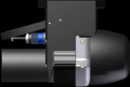
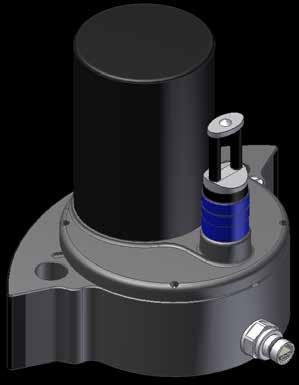
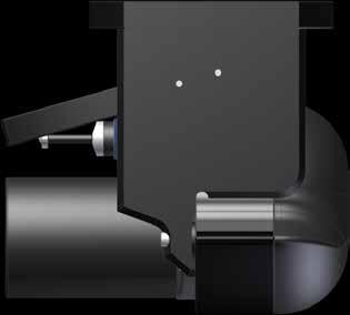
4 The system arrived in Portland, Oregon in a complete single protective case. Seahorse provided software licenses (QINSy, Hypack, EIVA, CARIS & POSPac), a laptop, AML sound speed profiler and the boat. The iwbms case contains all cables, GNSS antennas, power leads, mounting bolts, topside Integrated Sonar Interface Unit (isiu) and iwbms on a robust electrically & galvanically isolated mounting bracket. The cables from the wet-end must run up through the sonar pole.

5 Release Test Locations Intensive sea- trials were carried out in fresh and salt waters in Seattle, Washington and Portland, Oregon USA. Test sites were chosen to provide as much bottom type and watercolumn diversity as could reasonably be obtained. Test Sites: Seattle, WA USA Salt Water ( PSS), 12 C Portland, OR USA Fresh Water ( 0. 0 PSS), 7 C All depth are in metres
 100m Test Small Sewer Outfall 20m Test Large Sewer")
6 Seattle Test Locations Extinction Test Jetty Survey 220m Test 70m Test NOAA Ref (Wrecks) 100m Test Small Sewer Outfall 20m Test Large Sewer Outfall

7 Portland Test Locations Sand waves 14m Test Breakwater Cars Barge
 4. Use POSView v 7.")

8 Survey Setup System installation and software configuration procedure: 1. Mount iwbms use eye to align system parallel with boat keel 2. Mount GNSS antennas 5 / 8 bolts were already affixed and in-line with boat keel 3. Run cables and energize system connect to shore-side RTK (radio or NTRIP) 4. Use POSView v Installation Calibration & Control to determine Ref to Primary GNSS offsets. Once complete, repeat to ensure determined values are within +/- 1 cm 5. Use POSView GAMS Calibration Control to determine secondary antenna location. Once complete, repeat to ensure determined values are within +/- 1 cm 6. Setup Hypack 2014, offset the IMU and sonar to vessel Center of Rotation. 7. Take sound cast and verify to sonar local sound speed sensor 8. Survey... Survey Vessel SheHorse heading upstream on Willamette River, Portland. Sand ripples in Columbia River between Portland, Oregon and Vancouver, Washington
. Reference surface data was then cleaned. A cross-line was then run through the middle of the reference surface areas orthogonally to the surface generation lines (ex. East and/or West).")
9 Swath Performance Test Notes Reference surfaces were created with survey lines spaced one times water depth and 90degree swaths. Due to time, test areas were run in only one reciprocal direction (ex. North/South). Reference surface data was then cleaned. A cross-line was then run through the middle of the reference surface areas orthogonally to the surface generation lines (ex. East and/or West). Cross-lines were cleaned insofar as to only remove obvious gross outliers. Conditions in Seattle were not ideal with vessel roll up to 12. As the IMU was in the sonar head, the effect of the motion was seldom seen. Positions were refined with PPK (Post Processed Kinematic) utilizing a single base solution. 100m reference surface with 5 main-scheme lines and one cross-line.

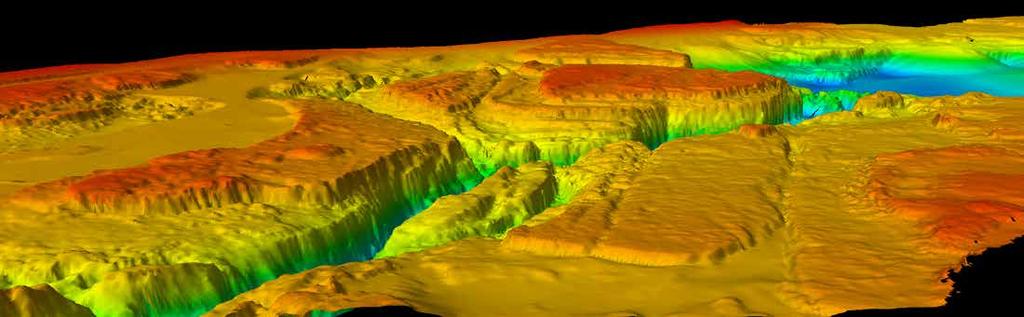
10 Extinction Test Seattle Max Depth > 270m Release Performance Notes

11 Extinction Test Seattle Max Depth > 270m Release Performance Notes


12 Jetty Survey - Seattle Suction dredge marks Rock dump line Jetty rocks detected to within +/-4cm at 6m depth

13 Jetty Survey - Seattle Release Performance Notes

14 Jetty Survey - Seattle The WBMS has a 179 swath width. This is practical for surveying up shorelines, bridge piers, bulkheads, etc. The swath was set to 130 and rotated to port by 24. This allowed for surveying below the water level by a few centimeters below the sonar draft.

15 Large Sewer Outfall - Seattle Release Performance Notes


16 Large Sewer Outfall - Seattle Despite heavy motion, pipe easily detected on multiple passes


17 Small Sewer Outfall - Seattle Small diameter pipe.

18 NOAA Reference Area (Wrecks) Seattle Release Performance Notes


19 Breakwater - Portland 3 Passes with excellent agreement Two cars one upside down with front wheels turned. Depth 9m

20 Barge - Portland 6 passes. Excellent agreement over rock, sand, mud and steel


21 Sand Waves - Portland Release Performance Notes


22 Sand Waves - Portland Easily discern 4-5cm sand ripples in 9m water depth.
23 NEW New Features & Changes Adaptive Ping Rate The bottom is here Adaptive ping rate allows user to set very long depth ranges (should the bottom drop suddenly). Meanwhile the system will continue to ping as fast as possible. The ping rate is here The farthest bottom detection sets the listening window and therefore the ping rate. The range is this Gives user highest along track sounding density and time to get a cup of coffee while online.


24 NEW New Features & Changes INSPECT Mode INSPECT mode changes the beamformer algorithm for highest detail returns in the near-nadir region (or anywhere that incidence angle is closest to 0 ) such as piers/bulkheads/breakwaters. Data outside of this region quickly deteriorates as incidence angle increases.


25 NEW New Features & Changes INSPECT Mode Bathy Mode INSPECT Mode Above shows results from detection of a 4 aluminum pipe at 4m water depth. Note that INSPECT mode detection size is 0.21m while Bathy mode is 0.46m.
26 NEW New Features & Changes Range Gate Ideal for those rare detail bank-bank survey requirements. Allows bottom detection to depths beyond lower depth gate without decreasing ping rate.

27 NEW New Features & Changes Automatic Zoom Automatically zooms into the effective swath coverage. This feature is most beneficial when used with Adaptive Ping Rate. Even while using a very deep lower depth gate, the seafloor will be in full view.

28 NEW New Features & Changes Wedge Zoom A wedge zoom function that allows user to zoom into any part of the wedge display for detailed viewing. Zoom windows may be resized to any dimension.


29 NEW New Features & Changes Cleaner Installation/Version Handling The system will now fully uninstall legacy GUI versions.


30 NEW New Features & Changes System Health Log A detailed log file is updated to alert of status/notices/warnings and errors. This log may then be copied to clipboard and pasted into an (subsea_support@norbit.com).
Meeting the Challenges of the IHO and LINZ Special Order Object Detection Requirements
 Meeting the Challenges of the IHO and LINZ Special Order Object Detection Requirements Erik Hammerstad Kongsberg Maritime P. O. Box 111, N-3191 Horten, Norway erik.oscar.hammerstad@kongsberg.com Abstract
Utilizing Vessel Based Mobile LiDAR & Bathymetry Survey Techniques for Survey of Four Southern California Breakwaters
 Utilizing Vessel Based Mobile LiDAR & Bathymetry Survey Techniques for Survey of Four Southern California Breakwaters Western Dredging Association: Pacific Chapter September 2012 Insert: Pipe Location
SeaBat T50-R Product Description
 Ultra-High Resolution Multibeam Echosounder March 2017 PD17419-3 Table of Contents SYSTEM OVERVIEW... 5 Introduction... 5 Typical Applications... 5 Warranty... 5 SYSTEM ARCHITECTURE... 6 SeaBat T50-R...
Specifications for Synchronized Sensor Pipe Condition Assessment (AS PROVIDED BY REDZONE ROBOTICS)
") Specifications for Synchronized Sensor Pipe Condition Assessment (AS PROVIDED BY REDZONE ROBOTICS) A. Scope of Work The work covered by these specifications consists of furnishing all materials, labor,
Specifications for Synchronized Sensor Pipe Condition Assessment (AS PROVIDED BY REDZONE ROBOTICS) A. Scope of Work The work covered by these specifications consists of furnishing all materials, labor,
BOTTOM MAPPING WITH EM1002 /EM300 /TOPAS Calibration of the Simrad EM300 and EM1002 Multibeam Echo Sounders in the Langryggene calibration area.
 BOTTOM MAPPING WITH EM1002 /EM300 /TOPAS Calibration of the Simrad EM300 and EM1002 Multibeam Echo Sounders in the Langryggene calibration area. by Igor Kazantsev Haflidi Haflidason Asgeir Steinsland Introduction
Sontek RiverSurveyor Test Plan Prepared by David S. Mueller, OSW February 20, 2004
 Sontek RiverSurveyor Test Plan Prepared by David S. Mueller, OSW February 20, 2004 INTRODUCTION Sontek/YSI has introduced new firmware and software for their RiverSurveyor product line. Firmware changes
Performance Analysis of the EdgeTech 6205 Swath Bathymetric Sonar
 Performance Analysis of the EdgeTech 6205 Swath Bathymetric Sonar Lisa Nicole Brisson, Lead Bathymetry Product Engineer, EdgeTech, Boca Raton, FL Damon Wolfe, Lead Bathymetry Sales Engineer, EdgeTech,
Certified Professionals in Hydrographic Solutions
 Certified Professionals in Hydrographic Solutions Client Satisfaction is our Deliverable Port of Brisbane Pty Ltd Port Surveys Certified Professionals in Hydrographic Surveying Tel +61 (0) 7 3258 4820
Evaluation of the Klein HydroChart 3500 Interferometric Bathymetry Sonar for NOAA Sea Floor Mapping
 Evaluation of the Klein HydroChart 3500 Interferometric Bathymetry Sonar for NOAA Sea Floor Mapping Yuhui Ai, Straud Armstrong and Dean Fleury L-3 Communications Klein Associates, Inc. 11 Klein Dr. Salem,
14/10/2013' Bathymetric Survey. egm502 seafloor mapping
 egm502 seafloor mapping lecture 10 single-beam echo-sounders Bathymetric Survey Bathymetry is the measurement of water depths - bathymetry is the underwater equivalent of terrestrial topography. A transect
Advantages of Using Combined Bathymetry and Side Scan Data in Survey Processing T.M. Hiller, L.N. Brisson
 Advantages of Using Combined Bathymetry and Side Scan Data in Survey Processing T.M. Hiller, L.N. Brisson EdgeTech, West WareHam MA, USA EdgeTech 6205 Combined Bathymetric and Side Scan Sonar EdgeTech
ICES Guidelines for Multibeam Echosounder Data (Compiled September 2006)
") ICES Guidelines for Multibeam Echosounder Data (Compiled September 2006) If you are considering producing a hydrographic survey please read the following information first. Your survey could be used to
ICES Guidelines for Multibeam Echosounder Data (Compiled September 2006) If you are considering producing a hydrographic survey please read the following information first. Your survey could be used to
ScanFish Katria. Intelligent wide-sweep ROTV for magnetometer surveys
 ScanFish Katria Intelligent wide-sweep ROTV for magnetometer surveys User-friendly control and monitoring software solution The ScanFish Katria comes with the ScanFish III Flight software, which is an
Recommended operating guidelines (ROG) for sidescan Sidescan sonar ROG in wrapper.doc English Number of pages: 9 Summary:
 for sidescan Sidescan sonar ROG in wrapper.doc English Number of pages: 9 Summary:") Title: Author(s): Document owner: Recommended operating guidelines (ROG) for sidescan sonar Dave Long (BGS) Dave Long (BGS) Reviewed by: Janine Guinan (MI) 07/09/07 Workgroup: MESH action: 2.1 Version:
Title: Author(s): Document owner: Recommended operating guidelines (ROG) for sidescan sonar Dave Long (BGS) Dave Long (BGS) Reviewed by: Janine Guinan (MI) 07/09/07 Workgroup: MESH action: 2.1 Version:
WMB-160F Multi-beam Fishing System
 WMB-160F Multi-beam Fishing System Take away the guess work and see what s REALLY below your boat! Seven Systems in One 2 WMB-160F WMB-160F Screen Shots The WMB-160F is a multi-beam sonar that has been
Sonar Bathymetry: Waquoit Bay NERR
 Sonar Bathymetry: Waquoit Bay NERR Determining the Functional Shallow Water Limitation for an Arrival Based Sonar Frederick A. Hegg Teledyne Benthos, Inc. 49 Edgerton Drive North Falmouth, MA 02556 fhegg@teledyne.com
INSIDE 16. Hydrographic Soundings, Sensors, and Bots. Dual-head Sonar Mapping. 25 A Case for Big Blue Data. Collaboration in the Air & on the Ground
 POSITIONING AND MEASUREMENT, ELEVATED AUGUST 2016 INSIDE: SURVEYING HYDROGRAPHY EDUCATION MAPPING UAS MACHINE CONTROL Hydrographic Soundings, Sensors, and Bots INSIDE 16 25 A Case for Big Blue Data 31
Surface Tracking Feature
 TELEDYNE RD INSTRUM ENTS A Teledyne Technologies Company Application Note FSA-022 (June 2008) Surface Tracking Feature 1 Introduction The following Application Note serves as a guide of how to use the
R/V Bat Galim EM302 & EM2040 Multibeam Echosounder System Review January 31 February 4, 2016
 R/V Bat Galim EM302 & EM2040 Multibeam Echosounder System Review January 31 February 4, 2016 Report prepared by: Paul D. Johnson University of New Hampshire Center for Coastal and Ocean Mapping / Joint
TS1. Ultrasonic Tank Sender. Installation and Operating Instructions. For TS1 Firmware v3.8. Page 1 INST-TS1-V13 18/11/10
 TS1 Ultrasonic Tank Sender Installation and Operating Instructions For TS1 Firmware v3.8 Page 1 Table of Contents 1. FEATURES... 3 2. SPECIFICATIONS... 3 3. DIMENSIONS... 4 4. MOUNTING AND INSTALLATION...
Failure of Wide Bay Pipeline in the Burnett River
 APGA Paper Date: 29 August 2015 Subject: Risk Mitigation for Trench Pipeline Under Shallow River Crossings Prepared by: Derek Boo Manager Planning and Engineering Company: APA Group Background: Beginning
Marine Towed Array Surveys of Ostrich Bay, Lake Erie and Puerto Rico.
 Marine Towed Array Surveys of Ostrich Bay, Lake Erie and Puerto Rico. Chet Bassani, Nagi Khadr, Chris Gibson and Jim McDonald Advanced Sensors and Analysis Div., SAIC Cary, NC Marine Towed Array (MTA)
Deploying the TCM-1 Tilt Current Meter in an Inverted (Hanging) Orientation By: Nick Lowell, Founder & President
 Orientation By: Nick Lowell, Founder & President") Lowell Instruments Application Note #TCMA Deploying the TCM-1 Tilt Current Meter in an Inverted (Hanging) Orientation By: Nick Lowell, Founder & President 1 Introduction The TCM-1 Tilt Current Meter (TCM)
Lowell Instruments Application Note #TCMA Deploying the TCM-1 Tilt Current Meter in an Inverted (Hanging) Orientation By: Nick Lowell, Founder & President 1 Introduction The TCM-1 Tilt Current Meter (TCM)
Figure 1 Example feature overview.
 1. Introduction This case focuses on the northeastern region of Onslow Bay, NC, and includes an initial shoreline, regional contour, wave gauges, inlets, dredging, and beach fills. Most of the features
DQM Annual Hopper QA Checks
 DQM Annual Hopper QA Checks The following document is intended to be a guide for conducting annual Dredge Quality Management quality assurance checks on hopper dredges. The procedures should provide general
FIG: 27.1 Tool String
 Bring up Radioactive Tracer service. Click Acquisition Box - Edit - Tool String Edit the tool string as necessary to reflect the tool string being run. This is important to insure proper offsets, filters,
BUYER S GUIDE AQUAlogger 530WTD
 OCEAN & ENVIRONMENTAL BUYER S GUIDE AQUAlogger 530WTD Wireless Temperature and Depth Logger AQUAlogger 530WTD The AQUAlogger 530WTD has an innovative design that includes the ability to transfer stored
RVIB Nathaniel B Palmer EM122 Multibeam Echosounder Sea Acceptance Trials NBP1405 June 14 June 19, 2014
 RVIB Nathaniel B Palmer EM122 Multibeam Echosounder Sea Acceptance Trials NBP1405 June 14 June 19, 2014 Report prepared by: Paul Johnson and Kevin Jerram University of New Hampshire Center for Coastal
R/V Kilo Moana EM122 Multibeam Echosounder Review KM August 9-13, 2015
 R/V Kilo Moana EM122 Multibeam Echosounder Review KM1514 - August 9-13, 2015 Report prepared by: Paul Johnson and Kevin Jerram University of New Hampshire Center for Coastal and Ocean Mapping/Joint Hydrographic
A PRACTICAL APPROACH TO QUALITY CONTROL AND QUALITY ANALYSIS OF DEPTH DATA
 A PRACTICAL APPROACH TO QUALITY CONTROL AND QUALITY ANALYSIS OF DEPTH DATA ABSTRACT Ulf Olsson, Mats Ericson, Stigbjörn Nilsson, Hans Öiås Hydrographic Office, Swedish Maritime Administration, Sweden Quality
High Ping Rate Profile Water Mode 12
 Application Note FSA-014 (October 2008) Revised October 2008 High Ping Rate Profile Water Mode 12 Introduction Water Mode 12 is the result of the continued evolution of the signal processing within our
OxyScan Graphic. Operating Instructions. UMS Micro-oxygen sensor 501. Microprocessor instrument
 OxyScan Graphic Operating Instructions UMS Micro-oxygen sensor 501 Microprocessor instrument Introduction Thank you for choosing the UMS Micro Oxygen Sensor 501 - a highly advanced product! Please read
Tutorial for the. Total Vertical Uncertainty Analysis Tool in NaviModel3
 Tutorial for the Total Vertical Uncertainty Analysis Tool in NaviModel3 May, 2011 1. Introduction The Total Vertical Uncertainty Analysis Tool in NaviModel3 has been designed to facilitate a determination
Multibeam and Laser: Combined High Resolution. Hydrographic Surveying for Civil Engineering Project Support
 Multibeam and Laser: Combined High Resolution Hydrographic Surveying for Civil Engineering Project Support John Dillon-Leetch,Port of London Authority Duncan Mallace, NetSurvey, UK Overview Introduction
METHODS PAPER: Downstream Bathymetry and BioBase Analyses of Substrate and Macrophytes
 Mactaquac Aquatic Ecosystem Study Report Series 2015-006 METHODS PAPER: Downstream Bathymetry and BioBase Analyses of Substrate and Macrophytes Ben Wallace, Jae Ogilvie and Wendy Monk 17 February 2015
R/V Hugh R. Sharp Multibeam Echosounder System Review. Multibeam Advisory Committee Sea Acceptance Team. October 31 st, Report prepared by:
 R/V Hugh R. Sharp Multibeam Echosounder System Review Multibeam Advisory Committee Sea Acceptance Team October 31 st, 2012 Report prepared by: Jonathan Beaudoin Center for Coastal and Ocean Mapping/Joint
Data Collection and Processing: Elwha Estuary Survey, February 2013
 Data Collection and Processing: Elwha Estuary Survey, February 2013 Ian Miller, WA Sea Grant Olympic Peninsula Field Office, 1502 E. Lauridsen Blvd #82, Port Angeles, WA 98362 immiller@u.washington.edu
Survey Technical Support Notes October 2015
 Survey Technical Support Notes October 2015 SonarMite with Trimble Access Overview: Trimble Access software, when connected to a SonarMite will store water depths associated with field measurements. Equipment:
The optimal position of a sidescan sonar towfish fixed to a shellfish vessel for very shallow surveys an experiment in the Dutch Wadden Sea
 Title: Author(s): Document owner: The optimal position of a sidescan sonar towfish fixed to a shellfish vessel for very shallow surveys an experiment in the Dutch Wadden Sea Ronnie van Overmeeren (TNO)
WG Marine Intruder Detection Sonar
 fire safety security defence The Westminster Marine Intruder Detection Sonar (WG MIDS) system is a single- or multi-head active sonar system designed to automatically detect and track underwater and surface
New Highly Productive Phased Array Ultrasonic Testing Machine for Aluminium Plates for Aircraft Applications
 19 th World Conference on Non-Destructive Testing 2016 New Highly Productive Phased Array Ultrasonic Testing Machine for Aluminium Plates for Aircraft Applications Christoph HENKEL 1, Markus SPERL 1, Walter
Automatic Isokinetic Sampler. ST5 Evo
 Automatic Isokinetic Sampler ST5 Evo Automatic Isokinetic Sampler ST5 Evo Moreover, in case of pump failure, the CU can work with a spare Dado PU unit or with any pump capable to supply the needed flowrate,
IFREMER, Department of Underwater Systems, Toulon, France. L u c i e Somaglino, P a t r i c k J a u s s a u d, R o main P i a s co, E w e n Raugel
 F i r s t s e a t r i a l s w i t h E M 2 0 4 0 m u l t i b e a m s o u n d e r i n n o v a t i v e i n t e g r a t i o n o n H y b r i d R O V A r i a n e IFREMER, Department of Underwater Systems, Toulon,
Compact Light Weight RC Boat for Hydrographic Surveys on Dams, Creeks, Rivers, storm water retention pits and other waterways.
 Accura Hydrographic RC Survey Boat Compact Light Weight RC Boat for Hydrographic Surveys on Dams, Creeks, Rivers, storm water retention pits and other waterways. Utilises Sounder & Transducer from CEE
ENVIRONMENT AGENCY GREAT OUSE AND 100 FT DRAIN QUARTERLY BATHYMETRIC SURVEY DECEMBER 2013 SITE SURVEY REPORT NO. H6787
 ENVIRONMENT AGENCY GREAT OUSE AND 100FT DRAIN QUARTERLY BATHYMETRIC SURVEY DECEMBER 2013 NO. H6787 LONGDIN & BROWNING (SURVEYS) LIMITED CHERRY TREE HOUSE CARMARTHEN ROAD SWANSEA SA1 1HE H6787 1 Measured
Panel Discussion on unmanned Hydrography
 Panel Discussion on unmanned Hydrography Overview Why bother General Types Autonomous Underwater Vehicle (AUV) Remotely Operated Vehicle (ROV) Unmanned Surface Vessels (USV) TerraSond s Experiences AUV
H ydrog ra p h ic S urve y Using SEABAT
 H ydrog ra p h ic S urve y Using SEABAT Hirokazu Mori, Tadashi Yamamoto and Isao Tedokon, Hydrographic Department, Japan Coast Guard The original was written in 1999, and our hydrographic surveys using
THE PMI AUTOMATED GAS/HELIUM PYCNOMETER PYC-G100A
 THE PMI AUTOMATED GAS/HELIUM PYCNOMETER PYC-G100A Not just products...solutions! Applications Gas/Helium pycnometery measures the true volume and density of samples like coal, char and ash particles, etc.
Note to Shipbuilders, shipowners, ship Managers and Masters. Summary
 MARINE GUIDANCE NOTE MGN 301 (M+F) Manoeuvring Information on Board Ships Note to Shipbuilders, shipowners, ship Managers and Masters This note supersedes Marine Guidance Note MGN 201 (M+F) Summary The
echo 200, 300, and 500 Series Owner s Manual
 echo 200, 300, and 500 Series Owner s Manual November 2013 190-01709-00_0A Printed in Taiwan All rights reserved. Under the copyright laws, this manual may not be copied, in whole or in part, without the
The optimal position of a sidescan sonar towfish fixed to a shellfish vessel for very shallow surveys an experiment in the Dutch Wadden Sea
 TNO report 2006-U-RO114/A The optimal position of a sidescan sonar towfish fixed to a shellfish vessel for very shallow surveys an experiment in the Dutch Wadden Sea NITG/Geological Survey Princetonlaan
from ocean to cloud PARAMETRIC SUB-BOTTOM PROFILER, A NEW APPROACH FOR AN OLD PROBLEM
 PARAMETRIC SUB-BOTTOM PROFILER, A NEW APPROACH FOR AN OLD PROBLEM Geoff Holland, Alcatel-Lucent Submarine Networks Geoff.holland@alcatel-lucent.com Alcatel-Lucent Submarine Networks Ltd, Christchurch Way,
MEASUREMENT COMMUNICATION INSIGHT
 Temperature & Depth MEASUREMENT COMMUNICATION INSIGHT CONTENTS Introduction to Aquatec Measuring Temperature and Depth 2 3 Aquatec s Temperature and Depth Loggers AQUAlogger 520 AQUAlogger 530 AQUAlogger
Vehicle- or rack-mounted liquefied gas meters, pump supplied
 Purpose This inspection procedure outline (IPO) defines the minimum tests which must be performed to ensure that basic volumetric measuring devices comply with the legislation. Application Rack/fixed metering
CONSTRUCTION OF LNG RECEIVING TERMINAL ON THE SAINT LAWRENCE TIDAL CURRENT CONDITIONS IN THE LEVIS AREA
 RABASKA PROJECT CONSTRUCTION OF LNG RECEIVING TERMINAL ON THE SAINT LAWRENCE TIDAL CURRENT CONDITIONS IN THE LEVIS AREA FINAL REPORT MARCH 2006 N/Réf. : 24237.360 3075, ch. des Quatre-Bourgeois Sainte-Foy
AUTOMATIC DREDGING PROFILE AND CONTOUR CONTROL
 AUTOMATIC DREDGING PROFILE AND CONTOUR CONTROL Jay Wise 1 ABSTRACT Phillips and Jordan, a leading excavating and disaster recovery contractor, was faced with the challenge to manage a civil contract involving
EXPERIMENTAL RESULTS OF GUIDED WAVE TRAVEL TIME TOMOGRAPHY
 18 th World Conference on Non destructive Testing, 16-20 April 2012, Durban, South Africa EXPERIMENTAL RESULTS OF GUIDED WAVE TRAVEL TIME TOMOGRAPHY Arno VOLKER 1 and Hendrik VOS 1 TNO, Stieltjesweg 1,
Relative Dosimetry. Photons
 Relative Dosimetry Photons What you need to measure! Required Data (Photon) Central Axis Percent Depth Dose Tissue Maximum Ratio Scatter Maximum Ratio Output Factors S c & S cp! S p Beam profiles Wedge
REACTOR 40 MECHANICAL Configuration Guide
 REACTOR 40 MECHANICAL Configuration Guide Important Safety Information WARNING See the Important Safety and Product Information guide in the product box for product warnings and other important information.
IDeA Competition Report. Electronic Swimming Coach (ESC) for. Athletes who are Visually Impaired
 for. Athletes who are Visually Impaired") IDeA Competition Report Electronic Swimming Coach (ESC) for Athletes who are Visually Impaired Project Carried Out Under: The Department of Systems and Computer Engineering Carleton University Supervisor
IDeA Competition Report Electronic Swimming Coach (ESC) for Athletes who are Visually Impaired Project Carried Out Under: The Department of Systems and Computer Engineering Carleton University Supervisor
BathySurvey A Trimble Access hydrographic survey module
 BathySurvey A Trimble Access hydrographic survey module Contents 1. Introduction... 3 2. Installation... 4 3. Main Screen... 5 4. Device... 6 5. Jobs... 7 6. Settings Odom Echotrac... 8 7. Settings Ohmex
Technology. In the My Files [My Files] submenu you can store all the programs that you have made on the NXT or downloaded from your computer.
![Technology. In the My Files [My Files] submenu you can store all the programs that you have made on the NXT or downloaded from your computer.](/thumbs/74/70002303.jpg "Technology. In the My Files [My Files] submenu you can store all the programs that you have made on the NXT or downloaded from your computer.") NXT Main Menu My Files Files are automatically placed into the appropriate folders. When you download a program using a Sound file to the NXT, the program will be placed under Software files while the
NXT Main Menu My Files Files are automatically placed into the appropriate folders. When you download a program using a Sound file to the NXT, the program will be placed under Software files while the
Product Description EM 3002
 Product Description EM 3002 Multibeam echo sounder Kongsberg EM 3002 Multibeam echo sounder Product description 855-164929 / Rev.A Note Kongsberg Maritime AS makes every effort to ensure that the information
Hydrographic Surveying Methods, Applications and Uses
 Definition: Hydrographic Surveying Methods, Applications and Uses It is the branch of surveying which deals with any body of still or running water such as a lake, harbor, stream or river. Hydrographic
Malta Survey activities
 Malta Survey activities Malta 19 September 2016 L. Facchin OGS National Institute of Oceanography and Experimental Geophysics Offshore Multibeam (MBES) Sub bottom profiling (SBP: Chirp or Boomer) Multichannel
USCGC HEALY WAGB-20 Final Report RD Instruments Inc. Ocean Surveyor 75 khz Prepared by: Ron Hippe Commissioning Dates: 3/27/2002-3/30/2002
 USCGC HEALY WAGB-20 Final Report Inc. Ocean Surveyor 75 khz Prepared by: Ron Hippe Commissioning Dates: 3/27/2002-3/30/2002 This report outlines the tests performed, and the results of Harbor and Sea testing
WL16 WATER LEVEL LOGGERS Submersible pressure transducer and USB datalogger combination
 WL16 WATER LEVEL LOGGERS Submersible pressure transducer and USB datalogger combination Warning: Non-vented water level loggers may have readings with errors of up to 250mm due to barometric pressure changes.
Bathyswath Technical Information
 www.bathyswath.com support@bathyswath.com Reference OD-5001 Classification Unclassified Version 7.04 Date July 2013 Copy number N/A (if applicable) Bathyswath Technical Information The information contained
Level MEASUREMENT 1/2016
 Level MEASUREMENT 1/2016 AGENDA 2 A. Introduction B. Float method C. Displacer method D. Hydrostatic pressure method E. Capacitance method G. Ultrasonic method H. Radar method I. Laser method J. Level
FPG8601 Force Balanced Piston Gauge
 FPG8601 Force Balanced Piston Gauge Reference Level Calibration System for very low pressure Pressure range: 0 to 15 kpa gauge, absolute and absolute differential Standard resolution: 0.010 Pa, high resolution
CYCLING TRACK SALES CONSULTING
 CYCLING TRACK SALES CONSULTING Overview The diversity of events in Cycling Track makes the sport one of the most complex for timekeeping. Quite different timing methods are required for the various types
Figure SM1: Front panel of the multipatcher software graphic user interface (GUI) at the beginning of multipatcher operation.
 at the beginning of multipatcher operation.") APPENDIX 2. Multipatcher Software Setup and Operation. The multipatcher program is organized into four panels. There are controls that allow the user to specify various parameters into the system. The
APPENDIX 2. Multipatcher Software Setup and Operation. The multipatcher program is organized into four panels. There are controls that allow the user to specify various parameters into the system. The
High Definition Laser Scanning (HDS) Underwater Acoustic Imaging and Profiling
 Underwater Acoustic Imaging and Profiling") High Definition Laser Scanning (HDS) Underwater Acoustic Imaging and Profiling Images at Depth: The Use of Acoustic Imaging on Large River Crossings A Case Study AGENDA Background of project Review of
High Definition Laser Scanning (HDS) Underwater Acoustic Imaging and Profiling Images at Depth: The Use of Acoustic Imaging on Large River Crossings A Case Study AGENDA Background of project Review of
E/V Nautilus EM302 Multibeam Echosounder System Review NA040 May 14, 2014
 E/V Nautilus EM302 Multibeam Echosounder System Review NA040 May 14, 2014 Report prepared by: Paul Johnson and Kevin Jerram University of New Hampshire Center for Coastal and Ocean Mapping/Joint Hydrographic
Vehicle-mounted meters, pump supplied
 Purpose This inspection procedure outline (IPO) defines the minimum tests which must be performed to ensure that basic volumetric measuring devices comply with the legislation. Application Vehicle-mounted
MODEL ANALOG ALTIMETER USER'S MANUAL 330KHZ, 1000M DEPTH RATED 0.2 TO 100FT OPERATING RANGE ANALOG OUTPUT
 MODEL 862-000-200 ANALOG ALTIMETER USER'S MANUAL 330KHZ, 1000M DEPTH RATED 0.2 TO 100FT OPERATING RANGE ANALOG OUTPUT DOCUMENT NO. 430-007H September 20, 2005 S/N IMAGENEX TECHNOLOGY CORP. 209-1875 BROADWAY
PMI Advanced Automated. Pulse Decay Permeameter APDP-10K-HP-101. Not just products... Solutions!
 PMI Advanced Automated Pulse Decay Permeameter APDP-10K-HP-101 Not just products... Solutions! DESCRIPTION The PMI s Advanced automated pulse decay Permeameter is used to measure gas permeability of samples
S-44 edition 5 The IHO s New Standard For Hydrographic Surveys Chris Howlett Head of Seabed Data Centre United Kingdom Hydrographic Office
 S-44 edition 5 The IHO s New Standard For Hydrographic Surveys Chris Howlett Head of Seabed Data Centre United Kingdom Hydrographic Office Chairman of IHO Working Group that created S-44 edition 5 S-44
Self Propelled Backhoe Dredger. Pat M BV CLASSED I 3/3 COASTAL PC 1400 AQUADIGGER MONTABERT VSS SHD HAMMER
 HUMBER WORK BOATS LTD. Self Propelled Backhoe Dredger Pat M BV CLASSED I 3/3 COASTAL PC 1400 AQUADIGGER MONTABERT VSS SHD HAMMER Self Propelled Backhoe Dredger, PAT-M When you charter the Pat M you charter
HOBO U20L Water Level Logger (U20L-0x) Manual
 Manual") Test Equipment Depot - 800.517.8431-99 Washington Street Melrose, MA 02176 - TestEquipmentDepot.com HOBO U20L Water Level Logger (U20L-0x) Manual The HOBO U20L Water Level Logger is used for monitoring
Test Equipment Depot - 800.517.8431-99 Washington Street Melrose, MA 02176 - TestEquipmentDepot.com HOBO U20L Water Level Logger (U20L-0x) Manual The HOBO U20L Water Level Logger is used for monitoring
Vortex Flow Meter Wafer or Flange Connection. - Steam - Liquid - Gas
 Vortex Flow Meter Wafer or Flange Connection - Steam - Liquid - Gas Working Principle & Circuit Diagram Working Principle When a column body placed in flowing fluids in pipe, a series of vortices will
High Precision Hydrography in Canada, the ST. Lawrence River Channel, HD Bathymetry, Production, Distribution and Updating
 High Precision Hydrography in Canada, the ST. Lawrence River Channel, HD Bathymetry, Production, Distribution and Updating Marc Journault Canada CHS, Louis Maltais Canada CHS, and Richard Sanfaçon Canada
MOTOROLA PTP 800 LICENSED ETHERNET MICROWAVE
 HIGH-THROUGHPUT COMMUNICATIONS FOR MULTI-SERVICE NETWORKS MOTOROLA PTP 800 LICENSED ETHERNET MICROWAVE PTP 800 solutions can efficiently and affordably transport the data, voice and video that your bandwidth-intensive
Lab 4: Pressure Gradients over a Wing
 2009 Lab 4: Pressure Gradients over a Wing Innovative Scientific Solutions Inc. 2766 Indian Ripple Road Dayton, OH 45440 (937)-429-4980 Lab 4: Pressure Gradients over a Wing Introduction: Like the previous
CITREX H4 Mobile gas flow analyser. The ideal mobile device for flow and pressure analysing.»
 CITREX H4 Mobile gas flow analyser «The ideal mobile device for flow and pressure analysing.» Ventilator tester for mobile use CITREX is designed for mobile and easy use while still meeting all requirements
Premium Series: Pressure, Differential Pressure and Level Transmitters. PASCAL Ci4. Chemical industry Mechanical engineering Process industry
 Made to measure. Since 1968. Premium Series: Pressure, Differential Pressure and Level Transmitters PASCAL Ci4 Chemical industry Mechanical engineering Process industry PREMIUM SERIES THE INTUITIVE ONE
Automatic Isokinetic Sampler. ST5 Evo
 Automatic Isokinetic Sampler ST5 Evo Automatic Isokinetic Sampler ST5 Evo Moreover, in case of pump failure, the CU can work with a spare Dado PU unit or with any pump capable to supply the needed flowrate,
The Evolution of an Autonomous Unmanned Surface Vessel and Software for Hydrographic Survey
 The Evolution of an Autonomous Unmanned Surface Vessel and Software for Hydrographic Survey Paul Donaldson In 2017, Leidos, Inc. participated in both the Gulf of Mexico Unmanned Systems Operational Demonstration
Nortek Technical Note No.: TN-021. Chesapeake Bay AWAC Evaluation
 Nortek Technical Note No.: TN-021 Title: Chesapeake Bay AWAC Evaluation Last Edited: October 5, 2004 Authors: Eric Siegel-NortekUSA, Chris Malzone-NortekUSA, Torstein Pedersen- Number of Pages: 12 Chesapeake
A STUDY OF THE LOSSES AND INTERACTIONS BETWEEN ONE OR MORE BOW THRUSTERS AND A CATAMARAN HULL
 A STUDY OF THE LOSSES AND INTERACTIONS BETWEEN ONE OR MORE BOW THRUSTERS AND A CATAMARAN HULL L Boddy and T Clarke, Austal Ships, Australia SUMMARY CFD analysis has been conducted on a 100m catamaran hull
1. Outline of the newly developed control technologies
 This paper describes a vertical lifting control and level luffing control design for newly developed, fully hydraulicdriven floating cranes. Unlike lattice boom crawler cranes for land use, the floating
GNSS Technology for the Determination of Real-Time Tidal Information
 GNSS Technology for the Determination of Real-Time Tidal Information Benjamin Kidder C-Nav Positioning Solutions European region Outline of Topics Covered Introduction to Tides Past and Present Methods
User Manual. Heads-Up Display (HUD) DiveCAN. Mechanical Button Version
 DiveCAN. Mechanical Button Version") User Manual Heads-Up Display (HUD) Mechanical Button Version DiveCAN Table of Contents 1. Introduction...4 1.1 Features...4 2. Physical Description...5 3. Reading the PPO2...6 3.1 Modified Smither s Code...7
User Manual Heads-Up Display (HUD) Mechanical Button Version DiveCAN Table of Contents 1. Introduction...4 1.1 Features...4 2. Physical Description...5 3. Reading the PPO2...6 3.1 Modified Smither s Code...7
Royce Interface Level Analyzer and Sensors
 Royce Interface Level Analyzer and Sensors Model 2511A Interface Level Analyzer The Model 2511A is capable of having the ultrasonic speed of sound signal from its transducers changed by the user in applications
Interim Operating Procedures for SonTek RiverSurveyor M9/S5
 Hydroacoustics Technical Working Group: Task 2.3 Fully operationalize auto-adapting ADCPs Interim Operating Procedures for SonTek RiverSurveyor M9/S5 P Campbell, E. Jamieson, F Rainville, A Du Cap, 2014
UNDERWATER SCIENCE. Multibeam Systems TECHNOLOGY FOR SUSTAINABLE FISHERIES
 UNDERWATER SCIENCE Multibeam Systems TECHNOLOGY FOR SUSTAINABLE FISHERIES SIMRAD ME70 SCIENTIFIC MULTIBEAM ECHO SOUNDER A scientific multibeam echo sounder can be seen as many EK sounders spread out in
Hydrographic Surveying at The Port of London
 Hydrographic Surveying at The Port of London John Dillon-Leetch Port and Terminal Technology 2009 14 th October, Antwerp Overview Introduction Surveying the Thames Navigational Charting High Resolution
ASSESSMENT OF CORRECTNESS OF INFORMATION OBTAINED FROM AUTOMATIC IDENTIFICATION OF SHIP S SYSTEM (AIS)
") ASSESSMENT OF CORRECTNESS OF INFORMATION OBTAINED FROM AUTOMATIC IDENTIFICATION OF SHIP S SYSTEM (AIS) Henryk Śniegocki Akademia Morska w Gdyni, Katedra Nawigacji Aleja Jana Pawła II 3, 81-345 Gdynia,
ASSESSMENT OF CORRECTNESS OF INFORMATION OBTAINED FROM AUTOMATIC IDENTIFICATION OF SHIP S SYSTEM (AIS) Henryk Śniegocki Akademia Morska w Gdyni, Katedra Nawigacji Aleja Jana Pawła II 3, 81-345 Gdynia,
VersaFlow Vortex 100 Vortex Flow Meter Technical Datasheet. Specification. The all-in-one solution. Highlights. Industries.
 VersaFlow Vortex 100 Vortex Flow Meter Technical Datasheet 34-VF-03-05 September 3rd, 2008 Specification The all-in-one solution The VERSAFLOW is the only vortex flowmeter with integrated pressure and
C-Flow Coriolis Mass Flow Meters
 Coriolis Mass Flow Meters Ready for Take Off The New Compact C-Flow Küppers Elektromechanik GmbH The C-Flow The C-Flow Coriolis Mass Meters consist of two components: KCE Transmitter KCM Transducer 2 KEM