DEFINITION OF THE SEABED IN NAVIGATION ROUTES THROUGH MUD AREAS
|
|
|
- Ashlyn Thomas
- 5 years ago
- Views:
Transcription
1 DEFINITION OF THE SEABED IN NAVIGATION ROUTES THROUGH MUD AREAS by R. K IR B Y and W. R. PARKER Institute o f Oceanographic Sciences, Crossway, Taunton, Somerset, U.K. and W. H. A. van OOSTRUM Directie Benedenrivieren, Rijkswaterstaat, Stationsweg, Hoek van Holland, Netherlands Paper presented at the International Hydrographic Technical Conference, May' 1979, and reproduced here by kind perm ission of the Organizers. Ottawa, ABSTRACT Over most types of seabed the interface between the seabed sediment and the overlying sea water column is sharp and clearly identified by survey echo sounders. However, in areas with a large mobile population of cohesive sediment (mud), dense layers of suspended sediment occur which are intermediate in character between muddy seawater and the settled mud o f the bed. Such suspensions (fluid mud) m ay create a surveying problem, owing to the multiple layering they produce on echo-sounder records. Echosounders alone do not allow an objective decision on which reflector should be regarded as the seabed for navigational purposes. A new technique has been devised involving detailed profiles o f in situ density through the suspensions using gamma-ray densimeters. This information, together with knowledge o f ship behaviour in dense media, facilitates decisions on what values o f in situ density should be defined as the seabed. A density value of 1.2 gm/cm3 is now used by the Netherlands Rijkswaterstaat to define the Nautical Depth since research has shown that suspensions o f lower density do not significantly impede the passage of ships. In Europort sudden influxes of sediment during storms produce layers up to 3.0 m in thickness which are detected by echo-sounders, and once the presence o f such a suspension resulted in the tem porary closure of the

2 port to supertanker navigation. However, density surveys reveal that on arrival these suspensions are o f very low density and thus do not present a hazard to navigation. Density surveys are also used to guide the maintenance dredging fleet to areas where the 1.2 gm/cm3 density level is shallower than the nominated datum for the channel or to areas where consolidation has progressed to a point where high production is possible. INTRODUCTION Estuaries and other coastal inlets commonly have circulation systems which retain silt, and the navigation routes approaching many o f the m ajor ports in the w orld have a mud deposition and a static suspension (fluid mud) problem. Recent work on cohesive sediment suspensions in coastal areas ( K i r b y and P a r k e r, 1977) [1] has revealed the behavioural link between sediment suspended in the water column and dense cohesive sediment suspensions on the seabed. This work shows that high energy events (tidal currents or storms) erode cohesive sediment and transport it into navigation channels. W hen first eroded the sediment is mixed throughout the water column as a homogeneous mobile suspension. As energy levels decline, the mobile suspensions begin to differentiate by settling, forming marked steps which continue to subside through the water column until dense layers several metres thick with density approxim ately 1.15 gm/cm3 are observed flowing along the bed. W hen the energy levels decrease sufficiently these mobile layers stagnate to form dense static suspensions. It is implicit, therefore, that in any areas where static suspensions occur, deposition has been rapid. Mobile suspensions com m only show multiple stratification, and although layering within the static suspensions is also common there is as yet no unequivocal causal link provin g the origin o f layering in the static suspensions. Follow ing stagnation the static suspensions continue to settle, and within a few hours they consolidate to a stage where they can be detected by norm al hydrographic survey echo sounders (figure 1). Once they become detectable these suspensions, variously termed fluid mud, creme de vase, slib, sling mud, etc., may present a survey problem since there is no evidence which can be confidently interpreted from the echo sounder record on which layer should be regarded as the seabed. The essence o f the problem is that such static suspensions appear very suddenly after storms, com m only have two or more layers and m ay reach 2-3 m in thickness, enough to intrude significantly above the channel datum. These suspensions have long been recognised by hydrographic surveyors. In the early days of lead-line techniques a special mud-lead was devised to cope w ith static suspension areas. Latterly echo-sounders have

3 F ig khz echo-sounder record showing dense static suspension overlying settled mud. Scale in feet. largely replaced the lead line. However, echo-sounders respond to both the density and acoustic velocity gradients of the medium. These acoustic properties cannot be readily converted into inform ation on the altitude within the suspension at which its mechanical properties may significantly affect ship handling. Thus, the information echo-sounders produce in such areas does not allow an objective decision to be made on where the seabed should be. The consequences of arbitrarily choosing one layer or another on the echo-sounder record in the absence of supporting information are considered by P a r k e r and K ir b y, 1977 [2 ]. To overcome this problem inform ation is required on the resistance of the static suspensions to the movement of the vessel. This requires two types of investigation. Firstly, measurement of the resistance of the substrata in ideal circumstances requires the in situ measurement of the shear strength or viscosity of the medium. However, neither can be measured with the degree of precision and rapidity necessary to be practical techniques for hydrographic surveying. Fortunately, both these properties are closely related to the density of the suspension and rapid in situ density measurement is now possible ( K i r b y and P a r k e r, 1974) [3 ]. Secondly, to complement the work on density structure, information is required on the behaviour of vessels sailing through such areas.
4 TECHNIQUE DEVELOPMENT In situ bulk density measurement may be achieved by the use o f scattered or transmitted radiation from a small radioactive source. The Atom ic Energy Research Establishment, Harwell, backscatter probe has a fast response rate and thus can be traversed rapidly. However, the spatial resolution is limited by the source/detector separation. The Harwell transmission gauge has a limited response rate but if it can be traversed slowly enough it has a high spatial resolution. The perform ance of these densimeters is discussed by P a r k e r, S i l l s and P a s k e, 1975 [4 ]. W hen either o f the density gauges is combined with a pressure sensor, the outputs can be recorder! o n a n X Y flatbed plotter and continuous vertical profiles of density versus depth obtained. By making many measurements within a designated area and applying the tidal correction, charts of depths to particular density horizons can be compiled. A survey echo sounder provides some continuity between each vertical profile. The behaviour of vessels sailing close to the surface and in the upper layers of dense suspensions has been studied on behalf of the Netherlands Rijkswaterstaat. Extensive model tests with a two-layer system to study the sailing and manoeuvring characteristics of supertankers in a channel with a soft bed have been carried out in the Netherlands Ship Model Basin. Prototype field tests were made with the 240,000 dwt supertanker Lepton sailing in the Europort Channels. Extensive investigations have also been made by NEDECO in the Chao Phraya River, Bangkok, and along the coast o f Surinam where ships sail in mud with a negative underkeel clearance. On the basis o f these investigations and a literature search it was found that densities up to 1.2 gm/cm3 had only a slight influence on manoeuvrability. It was therefore chosen as the Nautical Depth which is defined as a density within the suspension above whose altitude vessels can safety sail (figure 2). w a te r su rfa c e K-ifeT; K+T- Required Nautical Depth s o lid s e a b e d c ro s s s e c tio n I Of ta n k e r ,..d e r k e e l c le a ra n c e s ' gm cm,-3 suspended mud ' deeper s ta tic s u s p e n s io n causes _} negative underkeel clearance i 1'1^ unconsolidated 1-20 static suspension consolidated static i\3 5 suspension 7 / / / / AWNSV/'VV/XV^vVV/ / / / F ig. 2. Com parison of density profile and tanker cross section to illustrate the concept of Nautical D epth.

5 Thus channel datum increases are possible when the upper layers of the static suspensions are included in the underkeel clearance of supertankers. Following evaluation of the technique for surveying the three dimensional density structure, and research into ship behaviour in dense media, the approach has been applied to the Europort channels where dense suspensions at times present difficulties for supertanker entry. OPERATIONAL EXPERIENCE Background The area of the approach channels and waterways of Rotterdam- Europort is about 80 km2 (figure 3). In the open sea supertankers are sailing at full speed and the minimum underkeel clearance permitted is 20 % o f the draught. W hen the vessels slow in the approaches to Europort the minimum underkeel clearance allowed is 15 % of the draught. The approach channel is maintained at a depth of 24.5 m below chart datum. From the breakwaters inwards the channel datum is 23.5 m whilst the mud areas of the Maasmond, Caland Canal and Beer Canal are maintained at 22.5 m. Tankers drawing (58 ft (20.7 m) traverse these confined waters very slow ly with a minimum permitted underkeel clearance of 10 % (approxim ately ).

6 The inner parts of the Europort channels require virtually continuous dredging to maintain 22.5 m owing to mud deposition. Accretion is not a steady process, but is particularly severe in the winter when storms in the North Sea bring in large quantities of cohesive sediment in very short periods. The resulting suspensions may exceed 1.()4 gm/cm3 density and have been recognised as layers more than 1.0 m in thickness moving upstream in the Caland Canal ( K i r b y and P a r k e r, 1977) [1 ]. Following several days of severe weather during which these mobile suspensions penetrate into the Europort area, static suspensions up to 3.0 m in thickness containing as much as 5 600,000 m3 of sediment have been found. Over 70 % of the silt dredged from Rotterdam-Europort is believed to enter in this way from the sea, contributing to an annual maintenance dredging production of 13.5 million m3. Following stagnation and initial settling these suspensions become acoustically detectable. W ith a 3.0 m static suspension the first echo on a survey echosounder would come from a depth of 19.5 m below chart datum in a channel maintained at 22.5 m through which supertankers drawing 20.7 m regularly pass. Trials In September 1974 the Institute of Oceanographic Sciences and the Rijkswaterstaat carried out an evaluation o f the backscatter and transmission gauges in Europort. The evaluation showed that surveys could be carried out sufficiently rapidly for the technique to provide comprehensive coverage and to be processed and interpreted before conditions in the channel had changed significantly. Marked discrepancies occurred between horizons on the echo-sounder and the density horizons identified by the density gauges (figure 4), confirming that the echo sounder is inadequate to monitor the density structure within the suspension. 5 o 0) E MAASMOND CALAND CANAL a o Q R eflectors on ELAC 18 kh Echo Sounder st Density Horizons from B ackscatter Gauge n d rd. gm cm -3 I '1;;. 4. Comparison of echo-sounder and backscatter gauge profile along t lie axis of the Europort channels. Note that echo-sounder reflectors do not follow the density horizons.
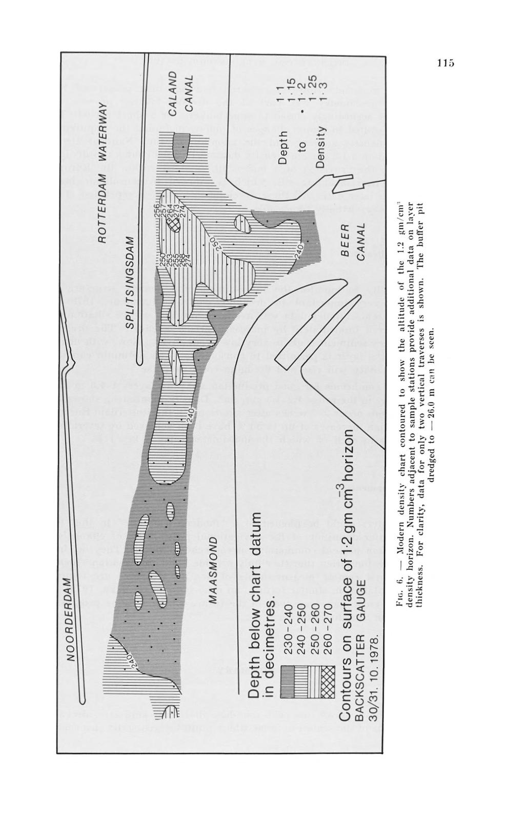
7 This is because the echo-sounder does not respond to progressive density changes, only to m ajor density inflections and other features within the suspension which provide a m ajor change in acoustic properties. These are not necessarily related to specific density values. By applying a tidal correction to the density soundings, bathymetric density charts reduced to various density horizons were produced. An early example o f such a chart is shown in figure 5. By contouring this chart it was possible to recognise areas where the critical 1.2 gm/cm3 density horizon had shoaled to less than the critical 22.5 m datum for the channel. Such a chart provides non-subjective inform ation upon which a harbourmaster can base a decision as to whether vessels can safely traverse the channel in the presence of deep static suspensions. Routine surveying procedure Follow in g this evaluation a system was developed which now incorporates a backscatter gauge, depth sensor and two-component inclinometer. W hen the survey vessel reaches the sample station the equipment package is traversed through the lower few metres of the water column and the static suspension at a lowering rate o f 20 cm/sec. Each profile takes sec to complete, and profiles in which the package inclination exceeds 3 are repeated. For more than three years the normal weekly echo-sounding surveys have been supplemented by these regular density surveys in which stations are measured each Monday, the data is partially processed on board and datum corrections are made so that the new density chart can be printed each Tuesday. Early on W ednesday a new density chart showing the altitude of the 1.2 gm/cm3 contour and other density information (figure 6) is issued to the various departments concerned. The main value of this density data is in its ability to guarantee the altitude of the 1.2 gm/cm3 horizon. Routine monitoring of this horizon over the last three years has revealed that it is far more stable than the top of the suspension indicated by the densimeters or echo-sounders. This allows a more realistic judgement to be made on the longer-term trends of sedimentation in the channel and allows the more extreme fluctuations to be recognised and accommodated within the survey and dredging programme. Figure 2 shows how in these exceptional circumstances supertankers can have a negative underkeel clearance according to the echo sounder although the underkeel clearance with respect to the 1.2 gm/cm3 horizon w ill still be 10%. The most serious influx of suspended sediment into Europort occurred in the first weeks of 1975 following gales in the North Sea. Echo-sounding surveys carried out immediately after these storms showed a least depth of 19.5 m due to the sudden arrival of a sediment body 3.0 m thick in places. Density records showed that this was chiefly

8 I'ig. 5. Karl}- density chart showing density values contoured to show the altitude of the 1.2 gm/cm 1 density horizon. ROTTERDAM WATERWAY
9
10 low density material. However research had not then progressed to a stage where densimetry was part o f the decision-making process, and Europort was accordingly closed to supertankers for a short period. This emergency resulted in major changes of policy, including the requirement for regular density surveys and the adoption of the Nautical Depth concept based on a 1.2 gm/cm3 density datum. Parallel changes in dredging policy led to the provision o f a buffer pit, dredged within the Europort channels to trap incoming silt, which is allowed to consolidate before dredging at a later date. A ll these developments make a repetition of the 1975 emergency virtually impossible. Dredging applications The ability to monitor the three-dimensional density structure has also proved very important in dredging control ( N e d e r l o f, 1978) [5]. W hilst only echo-sounder data was available any increase in siltation had to be countered immediately by increased dredging effort. The dredging of such watery sediment leads to very low productivity. Now, with density monitoring, the layer is permitted to consolidate to an optimum condition when productivity w ill rise and dredging costs decrease. Optimal conditions for good production are mud layers m thick w ith a density in the range gm/cm3. Density monitoring shows that these conditions occur 2 3 weeks after siltation. In the Rotterdam-Europort area production increases of up to 50 % have been achieved by several new developments in each of which the densimeters play a key role. Future developments Densimeters could be likened to a modern lead line in that they provide a better definition of the navigational possibilities of channels in mud areas than present commercial survey echo-sounders. They do, however, have the limitation that they only provide point information. Ideally, continuous and remote measurements of density structure are required with a presentation in similar form to an echo-sounder ( B a r k e r, 1979) [ 6 ]. Such developments are some way in the future although some progress is being made in this direction. SUMMARY Studies have shown that echo-sounders allow only subjective decisions on the altitude of the seabed in areas where multi-layered static suspensions occur.
11 Gamma-ray densimeters have been used to measure the three-dimensional density structure o f static suspensions in a navigable channel. This development has been accompanied by investigation of ship behaviour in dense media. On the basis of these studies a new concept, the Nautical Depth considered to be the 1.2 gm/cm3 density horizon, has been devised to define the effective seabed in soft mud areas. Experimental results and operational experience gained during the last few years have demonstrated the operational and cost benefit advantages possible with this technique. REFERENCES [1 ] K i r b y, R. & P a r k e r, W.R. (1977) : The physical characteristics and environmental significance of fine sediment suspensions in estuaries. National Academ y of Sciences, W ashington, D.C. In : Estuaries, Geophysics and the Environm ent, pp [2 ] P a r k e r, W.R. & K i r b y, R. (1977) : Fine sediment studies relevant to dredging practice and control. B H R A Fluid Engineering/Texas A & M University. Second International Symposium on D redging and Technology. B2, pp [3 ] K i r b y, R. & P a r k e r, W.R. (1974) : Seabed density measurements related to echosounder records. Dock & H arbour Authority. 54, pp [4 ] P a r k e r, W.R., S i l l s, G.C. & P a s k e, R.E.A. (1975) : In situ nuclear density measurements in dredging practice and control. B H R A F luid Engineering. First International Symposium on D redging Technology. B3, pp [5] Nederlof, L. (1978) : Consolidation of m ud in relation to dredging and the environment. W aterw ays Experim ent Station, Vicksburg, U.S.A. Second U S-European Symposium on the Environm ental Im pact of D redging and Dredged Material, pp [ 6 ] B a r k e r, D.J. (1979) : Density measurements in conjunction w ith echo sounding. The Hydrographic Journal, No. 14, pp
S-44 edition 5 The IHO s New Standard For Hydrographic Surveys Chris Howlett Head of Seabed Data Centre United Kingdom Hydrographic Office
 S-44 edition 5 The IHO s New Standard For Hydrographic Surveys Chris Howlett Head of Seabed Data Centre United Kingdom Hydrographic Office Chairman of IHO Working Group that created S-44 edition 5 S-44
Figure 4, Photo mosaic taken on February 14 about an hour before sunset near low tide.
 The Impact on Great South Bay of the Breach at Old Inlet Charles N. Flagg and Roger Flood School of Marine and Atmospheric Sciences, Stony Brook University Since the last report was issued on January 31
PORTS AUSTRALIA. PRINCIPLES FOR GATHERING AND PROCESSING HYDROGRAPHIC INFORMATION IN AUSTRALIAN PORTS (Version 1.5 November 2012)
") PORTS AUSTRALIA PRINCIPLES FOR GATHERING AND PROCESSING HYDROGRAPHIC INFORMATION IN AUSTRALIAN PORTS (Version 1.5 November 2012) PREFACE These Principles have been prepared by the Hydrographic Surveyors
PORTS AUSTRALIA PRINCIPLES FOR GATHERING AND PROCESSING HYDROGRAPHIC INFORMATION IN AUSTRALIAN PORTS (Version 1.5 November 2012) PREFACE These Principles have been prepared by the Hydrographic Surveyors
CHAPTER 5: VACUUM TEST WITH VERTICAL DRAINS
 CHAPTER 5: VACUUM TEST WITH VERTICAL DRAINS 5.1 Introduction Using surcharging as the sole soil consolidation mean can take a long time to reach the desired soil settlement. Soil consolidation using prefabricated
INTERNATIONAL HYDROGRAPHIC SURVEY STANDARDS
 INTERNATIONAL HYDROGRAPHIC SURVEY STANDARDS by Gerald B. MILLS 1 I. Background The International Hydrographic Organization (IHO) traces its origin to the establishment of the International Hydrographic
ENVIRONMENT AGENCY GREAT OUSE AND 100 FT DRAIN QUARTERLY BATHYMETRIC SURVEY DECEMBER 2013 SITE SURVEY REPORT NO. H6787
 ENVIRONMENT AGENCY GREAT OUSE AND 100FT DRAIN QUARTERLY BATHYMETRIC SURVEY DECEMBER 2013 NO. H6787 LONGDIN & BROWNING (SURVEYS) LIMITED CHERRY TREE HOUSE CARMARTHEN ROAD SWANSEA SA1 1HE H6787 1 Measured
from ocean to cloud PARAMETRIC SUB-BOTTOM PROFILER, A NEW APPROACH FOR AN OLD PROBLEM
 PARAMETRIC SUB-BOTTOM PROFILER, A NEW APPROACH FOR AN OLD PROBLEM Geoff Holland, Alcatel-Lucent Submarine Networks Geoff.holland@alcatel-lucent.com Alcatel-Lucent Submarine Networks Ltd, Christchurch Way,
14/10/2013' Bathymetric Survey. egm502 seafloor mapping
 egm502 seafloor mapping lecture 10 single-beam echo-sounders Bathymetric Survey Bathymetry is the measurement of water depths - bathymetry is the underwater equivalent of terrestrial topography. A transect
Geospatial Positioning Accuracy Standards Part 5: Standards for Nautical Charting Hydrographic Surveys - Public Review Draft
 Appendix B FGDC Hydrographic Accuracy Standard Geospatial Positioning Accuracy Standards Part 5: Standards for Nautical Charting Hydrographic Surveys - Public Review Draft Subcommittee on Marine and Coastal
HELSINKI COMMISSION HELCOM SAFE NAV 4/2014 Group of Experts on Safety of Navigation Fourth Meeting Helsinki, Finland, 4 February 2014
 HELSINKI COMMISSION HELCOM SAFE NAV 4/2014 Group of Experts on Safety of Navigation Fourth Meeting Helsinki, Finland, 4 February 2014 Agenda Item 3 Accidents and ship traffic in the Baltic Sea Document
ICES Guidelines for Multibeam Echosounder Data (Compiled September 2006)
") ICES Guidelines for Multibeam Echosounder Data (Compiled September 2006) If you are considering producing a hydrographic survey please read the following information first. Your survey could be used to
ICES Guidelines for Multibeam Echosounder Data (Compiled September 2006) If you are considering producing a hydrographic survey please read the following information first. Your survey could be used to
THE CHALLENGES OF A LARGE-AREA BATHYMETRIC SURVEY
 THE CHALLENGES OF A LARGE-AREA BATHYMETRIC SURVEY Agenda: - Introduction - Tender - Project Planning - Survey - Processing - Delivery - Conclusion 2 Introduction We know less of the oceans at our feet,
Paper for consideration by ENC Working Group. Use of AU6 ENC cells as an option for Bathymetric ENCs (benc)
") Paper for consideration by ENC Working Group Use of AU6 ENC cells as an option for Bathymetric ENCs (benc) Submitted by: Alvaro Sanchez (AHS) Executive Summary: Compilation of high density bathymetric
Paper for consideration by ENC Working Group Use of AU6 ENC cells as an option for Bathymetric ENCs (benc) Submitted by: Alvaro Sanchez (AHS) Executive Summary: Compilation of high density bathymetric
Request Number IR1-12: Flow Passage. Information Request
 Request Number IR1-12: Flow Passage Information Request Provide additional information about the 100 metre flow passage channel scenario between the Westshore Terminals and the proposed Project terminal
AN OFFSHORE TIDE GAUGE
 AN OFFSHORE TIDE GAUGE by Toshio Y a m a d a and Kinji I w a d a Hydrographic Department of Japan 1. INTRODUCTION Between October and December 1970 the Hydrographic Department of Japan carried out jointly
Cross-shore sediment transports on a cut profile for large scale land reclamations
 Cross-shore sediment transports on a cut profile for large scale land reclamations Martijn Onderwater 1 Dano Roelvink Jan van de Graaff 3 Abstract When building a large scale land reclamation, the safest
DUKC Chart Overlay. Presentation to IHO TWL and DQ Working Groups Wollongong, March 2014
 DUKC Chart Overlay Presentation to IHO TWL and DQ Working Groups Wollongong, March 2014 Outline Who is OMC? DUKC description & methodology. DUKC Chart Overlay concept. Chart Overlay application example.
Real Time Surveying GPS and HYDRO Software for Tide and Swell Compensation
 Real Time Surveying GPS and HYDRO Software for Tide and Swell Compensation by Mr Michael Walker, B.Surv. (Otago) HYDRO Division Trimble Navigation New Zealand Ltd. Abstract This paper focuses on the use
Concepts & Phenomena
 Concepts & Phenomena in coastal and port sedimentation R. Kamalian Ports and Maritime Organization of Iran and PIANC-Iran 7 9 December 2015 What is the problem? Many harbours have sedimentation problems
Examples of Carter Corrected DBDB-V Applied to Acoustic Propagation Modeling
 Naval Research Laboratory Stennis Space Center, MS 39529-5004 NRL/MR/7182--08-9100 Examples of Carter Corrected DBDB-V Applied to Acoustic Propagation Modeling J. Paquin Fabre Acoustic Simulation, Measurements,
Feasibility Study for Dredging of Khaprabhanga Chapalir Don River in Patuakhali District for Improvement of Navigability
 IOSR Journal of Engineering (IOSRJEN) ISSN (e): 2250-3021, ISSN (p): 2278-8719 Vol. 04, Issue 06 (June. 2014), V3 PP 32-38 www.iosrjen.org Feasibility Study for Dredging of Khaprabhanga Chapalir Don River
AHO s experience on HD bathymetric ENCs
 AHO s experience on HD bathymetric ENCs ENCWG3 Wollongong 16 18 April 2018 Alvaro Sanchez DD Charting Quality Assurance, Standards and Specifications Australian Hydrographic Office Background 2016 As part
Utilizing Vessel Based Mobile LiDAR & Bathymetry Survey Techniques for Survey of Four Southern California Breakwaters
 Utilizing Vessel Based Mobile LiDAR & Bathymetry Survey Techniques for Survey of Four Southern California Breakwaters Western Dredging Association: Pacific Chapter September 2012 Insert: Pipe Location
EXPERIMENTAL STUDY ON THE DISCHARGE CHARACTERISTICS OF SLUICE FOR TIDAL POWER PLANT
 EXPERIMENTAL STUDY ON THE DISCHARGE CHARACTERISTICS OF SLUICE FOR TIDAL POWER PLANT Sang-Ho Oh 1, Kwang Soo Lee 1 and Dal Soo Lee 1 The discharge characteristics of sluice caisson for tidal power plant
.y..o ~ - \ o ~ ~~~I bl:..ill & ~j.a,_,.,ui J-1 ~4 b~
 Qatar Univ. Sci. J. (1993), 13(2.): 353-357 SEASONAL VARIATIONS OF ACOUSTIC PROPERTIES IN ROPME SEA AREA By A. A. H. EL-GINDY* *Department of Marine Sciences, Faculty of Science, University of Qatar, Doha,
NEED FOR SUPPLEMENTAL BATHYMETRIC SURVEY DATA COLLECTION
 305 West Grand Avenue, Suite 300 Montvale, New Jersey 07645 Phone 201.930.9890 Fax 201.930.9805 www.anchorqea.com M EMORANDUM To: Caroline Kwan and Nica Klaber U.S. Environmental Protection Agency Region
BOTTOM MAPPING WITH EM1002 /EM300 /TOPAS Calibration of the Simrad EM300 and EM1002 Multibeam Echo Sounders in the Langryggene calibration area.
 BOTTOM MAPPING WITH EM1002 /EM300 /TOPAS Calibration of the Simrad EM300 and EM1002 Multibeam Echo Sounders in the Langryggene calibration area. by Igor Kazantsev Haflidi Haflidason Asgeir Steinsland Introduction
Determination Of Nearshore Wave Conditions And Bathymetry From X-Band Radar Systems
 Determination Of Nearshore Wave Conditions And Bathymetry From X-Band Radar Systems Okey G. Nwogu Dept. of Naval Architecture and Marine Engineering University of Michigan Ann Arbor, MI 489 phone: (734)
Hydrographic Surveying Methods, Applications and Uses
 Definition: Hydrographic Surveying Methods, Applications and Uses It is the branch of surveying which deals with any body of still or running water such as a lake, harbor, stream or river. Hydrographic
Minimum depth, mean depth or something in between?
 Minimum depth, mean depth or something in between? Tannaz H. Mohammadloo a, Mirjam Snellen a, Dick G. Simons a, Ben Dierikx b, Simon Bicknese b a Acoustics Group, Department of Control & Operations, Faculty
HARBOUR SEDIMENTATION - COMPARISON WITH MODEL
 HARBOUR SEDIMENTATION - COMPARISON WITH MODEL ABSTRACT A mobile-bed model study of Pointe Sapin Harbour, in the Gulf of St. Lawrence, resulted in construction of a detached breakwater and sand trap to
DEAD-ENDCHANNELFLUSHINGINHARBORS
 DEAD-ENDCHANNELFLUSHNGNHARBORS PURPOSE: The purpose of this technical note is to present some design con- siderations which benefit dead-end channel flushing. Some of these factors can also be used to
Measurement of vertical motions of bulk carriers navigating in port entrance channels
 HYDROGRAPHIC CONFERENCE Technical Awareness Seminar 2007 Cape Town, 19 21 June 2007 Measurement of vertical motions of bulk carriers navigating in port entrance channels J Moes CSIR, PO Box 320, Stellenbosch,
Chapter 2 Hydrostatics and Control
 Chapter 2 Hydrostatics and Control Abstract A submarine must conform to Archimedes Principle, which states that a body immersed in a fluid has an upward force on it (buoyancy) equal to the weight of the
Study of Passing Ship Effects along a Bank by Delft3D-FLOW and XBeach1
 Study of Passing Ship Effects along a Bank by Delft3D-FLOW and XBeach1 Minggui Zhou 1, Dano Roelvink 2,4, Henk Verheij 3,4 and Han Ligteringen 2,3 1 School of Naval Architecture, Ocean and Civil Engineering,
Determination of Nearshore Wave Conditions and Bathymetry from X-Band Radar Systems
 Determination of Nearshore Wave Conditions and Bathymetry from X-Band Radar Systems Okey G. Nwogu Dept. of Naval Architecture and Marine Engineering University of Michigan Ann Arbor, MI 48109 Phone: (734)
The optimal position of a sidescan sonar towfish fixed to a shellfish vessel for very shallow surveys an experiment in the Dutch Wadden Sea
 Title: Author(s): Document owner: The optimal position of a sidescan sonar towfish fixed to a shellfish vessel for very shallow surveys an experiment in the Dutch Wadden Sea Ronnie van Overmeeren (TNO)
Data Collection and Processing: Elwha Estuary Survey, February 2013
 Data Collection and Processing: Elwha Estuary Survey, February 2013 Ian Miller, WA Sea Grant Olympic Peninsula Field Office, 1502 E. Lauridsen Blvd #82, Port Angeles, WA 98362 immiller@u.washington.edu
COUPLED MANAGEMENT STRATEGY LAKE CATHIE ESTUARY & COAST
 Lake Cathie Progress Association Inc. ABN 28 251 433 854 P.O. Box 247 Lake Cathie NSW 2445 PHONE/FAX: 02 6584 8211 EMAIL: r3packag@bigpond.com 20 th October 2009 Port Macquarie Hastings Council PO Box
CROSS-SHORE SEDIMENT PROCESSES
 The University of the West Indies Organization of American States PROFESSIONAL DEVELOPMENT PROGRAMME: COASTAL INFRASTRUCTURE DESIGN, CONSTRUCTION AND MAINTENANCE A COURSE IN COASTAL DEFENSE SYSTEMS I CHAPTER
Inlet Management Study for Pass-A-Grille and Bunces Pass, Pinellas County, Florida
 Inlet Management Study for Pass-A-Grille and Bunces Pass, Pinellas County, Florida Final Report Submitted By Ping Wang, Ph.D., Jun Cheng Ph.D., Zachary Westfall, and Mathieu Vallee Coastal Research Laboratory
Engineering Surveying - II CE313. Hydrographic Survey Lecture 06 Muhammad Noman
 Engineering Surveying - II CE313 Hydrographic Survey Lecture 06 Muhammad Noman Hydrographic Surveying Hydrographic surveying is the branch of the survey which deal with any body of still or running water
CHAPTER 134 INTRODUCTION
 CHAPTER 134 NEW JETTIES FOR TUNG-KANG FISHING HARBOR, TAIWAN Chi-Fu Su Manager Engineering Department Taiwan Fisheries Consultants, Inc. Taipei, Taiwan INTRODUCTION Tung-Kang Fishing Harbor, which is about
High Precision Hydrography in Canada, the ST. Lawrence River Channel, HD Bathymetry, Production, Distribution and Updating
 High Precision Hydrography in Canada, the ST. Lawrence River Channel, HD Bathymetry, Production, Distribution and Updating Marc Journault Canada CHS, Louis Maltais Canada CHS, and Richard Sanfaçon Canada
Learn more at
 Full scale model tests of a steel catenary riser C. Bridge 1, H. Howells 1, N. Toy 2, G. Parke 2, R. Woods 2 1 2H Offshore Engineering Ltd, Woking, Surrey, UK 2 School of Engineering, University of Surrey,
SEDIMENT BUDGET OF LIDO OF PELLESTRINA (VENICE) Written by Marcello Di Risio Under the supervision of Giorgio Bellotti and Leopoldo Franco
 Written by Marcello Di Risio Under the supervision of Giorgio Bellotti and Leopoldo Franco") SEDIMENT BUDGET OF LIDO OF PELLESTRINA (VENICE) Written by Marcello Di Risio Under the supervision of Giorgio Bellotti and Leopoldo Franco Table of contents: 1. Introduction...3 2. Protection structures
SEDIMENT BUDGET OF LIDO OF PELLESTRINA (VENICE) Written by Marcello Di Risio Under the supervision of Giorgio Bellotti and Leopoldo Franco Table of contents: 1. Introduction...3 2. Protection structures
AIRFLOW GENERATION IN A TUNNEL USING A SACCARDO VENTILATION SYSTEM AGAINST THE BUOYANCY EFFECT PRODUCED BY A FIRE
 - 247 - AIRFLOW GENERATION IN A TUNNEL USING A SACCARDO VENTILATION SYSTEM AGAINST THE BUOYANCY EFFECT PRODUCED BY A FIRE J D Castro a, C W Pope a and R D Matthews b a Mott MacDonald Ltd, St Anne House,
Hydrographic Surveying at The Port of London
 Hydrographic Surveying at The Port of London John Dillon-Leetch Port and Terminal Technology 2009 14 th October, Antwerp Overview Introduction Surveying the Thames Navigational Charting High Resolution
Shoreline Response to an Offshore Wave Screen, Blairgowrie Safe Boat Harbour, Victoria, Australia
 Shoreline Response to an Offshore Wave Screen, Blairgowrie Safe Boat Harbour, Victoria, Australia T.R. Atkins and R. Mocke Maritime Group, Sinclair Knight Merz, P.O. Box H615, Perth 6001, Australia ABSTRACT
Beach profile surveys and morphological change, Otago Harbour entrance to Karitane May 2014 to June 2015
 Beach profile surveys and morphological change, Otago Harbour entrance to Karitane May 2014 to June 2015 Prepared for Port Otago Ltd Martin Single September 2015 Shore Processes and Management Ltd Contact
High Frequency Acoustical Propagation and Scattering in Coastal Waters
 High Frequency Acoustical Propagation and Scattering in Coastal Waters David M. Farmer Graduate School of Oceanography (educational) University of Rhode Island Narragansett, RI 02882 phone: (401) 874-6222
7.4 Temperature, Salinity and Currents in Jamaica Bay
 7.4 Temperature, Salinity and Currents in Jamaica Bay Arnold Gordon, Bruce Huber and Robert Houghton 7.4.1 INTRODUCTION Jamaica Bay stratification is weakly indicative of a shallow, tidally active environment,
Breakwaters and closure dams CT 5308 Exercise 2011: Pointe Noire, Congo
 Breakwaters and closure dams CT 5308 Exercise 2011: Pointe Noire, Congo The town of Pointe Noire is the main port city in the Republic of the Congo and sits on the south-western African coast some 150
RAMSTM. 360 Riser and Anchor-Chain Integrity Monitoring for FPSOs
 RAMS 360 Riser and Anchor-Chain Integrity Monitoring for FPSOs Introduction to RAMS Tritech s RAMS is a 360 anchor-chain and riser integrity monitoring system for Floating Production Storage and Offloading
Comparison of Predicted and Measured Shoaling at Morro Bay Harbor Entrance, California
 Comparison of Predicted and Measured Shoaling at Morro Bay Harbor Entrance, California by Edward F. Thompson, Inocencio P. DiRamos, and Robert R. Bottin, Jr. PURPOSE: This Coastal and Hydraulics Engineering
The optimal position of a sidescan sonar towfish fixed to a shellfish vessel for very shallow surveys an experiment in the Dutch Wadden Sea
 TNO report 2006-U-RO114/A The optimal position of a sidescan sonar towfish fixed to a shellfish vessel for very shallow surveys an experiment in the Dutch Wadden Sea NITG/Geological Survey Princetonlaan
E4014 Construction Surveying. Hydrographic Surveys
 E4014 Construction Surveying Hydrographic Surveys Charts And Maps Hydrographic Chart an information medium and a tool for maritime traffic for the safety and ease of navigation contains information on
BERNOULLI EFFECTS ON PRESSURE.ACTIVATED W ATER LEVEL GAUGES
 International Hydrographic R eview, Monaco, LV (2), July 1978. BERNOULLI EFFECTS ON PRESSURE.ACTIVATED W ATER LEVEL GAUGES by Langley R. MUIR Ocean and Aquatic Sciences, Central Region, Burlington, Ontario,
Paper for Consideration by HSSC8 Development of an Additional Bathymetry Layer standard based on S-57/S-52
 Paper for Consideration by HSSC8 Development of an Additional Bathymetry Layer standard based on S-57/S-52 Submitted by: CIRM, Germany, USA (NOAA) Executive Summary: Proposal for the standardization of
SOME WATER CHARACTERISTICS OF ESTUARIES IN INDONESIA
 SOME WATER CHARACTERISTICS OF ESTUARIES IN INDONESIA by HENK L. UKTOLSEYA 1 ABSTRACT This paper describes the results obtained during several hydro-oceanographical observations of some estuaries in Indonesia
A real time vessel air gap monitoring system
 Journal of Physics: Conference Series A real time vessel air gap monitoring system To cite this article: D McStay and K Thabeth 2009 J. Phys.: Conf. Ser. 178 012038 View the article online for updates
A FINAL REPORT BY PARTRAC LIMITED: MAY 2006
 A FINAL REPORT BY PARTRAC LIMITED: MAY 26 Measurement of Suspended Sediment Concentration & Tidal Current During Dredging Operations and Post-Dredge at the Offshore Disposal Area, Poole, Dorset QUALITY
Greenup Lock Filling and Emptying System Study
 Fourth LACCEI International Latin American and Caribbean Conference for Engineering and Technology (LACCET 2006) Breaking Frontiers and Barriers in Engineering: Education, Research and Practice 21-23 June
Comparative temperature measurements in an experimental borehole heat exchanger. Vincent Badoux 1, Rita Kobler 2
 European Geothermal Congress 2016 Strasbourg, France, 19-24 Sept 2016 Comparative temperature measurements in an experimental borehole heat exchanger Vincent Badoux 1, Rita Kobler 2 1 GEOTEST AG, Bernstrasse
Challenges in determining water surface in airborne LiDAR topobathymetry. Amar Nayegandhi, Dewberry 15 th Annual JALBTCX Workshop, June 11 th 2014
 Challenges in determining water surface in airborne LiDAR topobathymetry Amar Nayegandhi, Dewberry 15 th Annual JALBTCX Workshop, June 11 th 2014 Why topobathy LiDAR? Complements acoustic (multi-beam sonar)
Chart Specifications of the IHO Publication S-4 (Formerly M-4)
") TWLWG3/4/11A Publication S-4 (Formerly M-4) Attached to this document is an extract from IHO Publication S-4 which relate to Tidal and Water Level Information. The TWLWG is requested to review this information
TWLWG3/4/11A Publication S-4 (Formerly M-4) Attached to this document is an extract from IHO Publication S-4 which relate to Tidal and Water Level Information. The TWLWG is requested to review this information
Currents measurements in the coast of Montevideo, Uruguay
 Currents measurements in the coast of Montevideo, Uruguay M. Fossati, D. Bellón, E. Lorenzo & I. Piedra-Cueva Fluid Mechanics and Environmental Engineering Institute (IMFIA), School of Engineering, Research
IMPACTS OF COASTAL PROTECTION STRATEGIES ON THE COASTS OF CRETE: NUMERICAL EXPERIMENTS
 IMPACTS OF COASTAL PROTECTION STRATEGIES ON THE COASTS OF CRETE: NUMERICAL EXPERIMENTS Tsanis, I.K., Saied, U.M., Valavanis V. Department of Environmental Engineering, Technical University of Crete, Chania,
The Impact on Great South Bay of the Breach at Old Inlet Charles N. Flagg School of Marine and Atmospheric Sciences, Stony Brook University
 The Impact on Great South Bay of the Breach at Old Inlet Charles N. Flagg School of Marine and Atmospheric Sciences, Stony Brook University The previous report provided a detailed look at the conditions
Drilling Efficiency Utilizing Coriolis Flow Technology
 Session 12: Drilling Efficiency Utilizing Coriolis Flow Technology Clement Cabanayan Emerson Process Management Abstract Continuous, accurate and reliable measurement of drilling fluid volumes and densities
Robin J. Beaman. School of Earth and Environmental Sciences, James Cook University, Cairns, Qld 4870, Australia.
 Robin J. Beaman School of Earth and Environmental Sciences, James Cook University, Cairns, Qld 4870, Australia. Email: robin.beaman@jcu.edu.au Seminar to SSSI Qld Hydrography Coping with Nature, Brisbane,
BASELINE SURVEY, VISUAL - SITE SPECIFIC
 BASELINE SURVEY, VISUAL - SITE SPECIFIC Introduction As stated in SEPA s policy and in the Fish Farm Manual (1998), scientific data are required by SEPA in order to assess the existing condition on the
Design and Planning Considerations For a Seabed Survey
 Design and Planning Considerations For a Seabed Survey Vera Quinlan Hydrographer & Data Processor Seabed Survey Overview Survey Platform - What boat do I use? Survey Area / depth of water / objective &
DUKC DYNAMIC UNDER KEEL CLEARANCE
 DUKC DYNAMIC UNDER KEEL CLEARANCE Information Booklet Prepared in association with Marine Services Department 10/10/2005 Dynamic Under Keel Clearance (DUKC) integrates real time measurement of tides and
Comparisons of Physical and Numerical Model Wave Predictions with Prototype Data at Morro Bay Harbor Entrance, California
 Comparisons of Physical and Numerical Model Wave Predictions with Prototype Data at Morro Bay Harbor Entrance, California by Robert R. Bottin, Jr. and Edward F. Thompson PURPOSE: This Coastal and Hydraulics
INTERNATIONAL HYDROGRAPHIC ORGANIZATION
 INTERNATIONAL HYDROGRAPHIC ORGANIZATION S-67 MARINERS GUIDE TO ACCURACY OF ELECTRONIC NAVIGATIONAL CHARTS (ENC) Edition 0.5 July 2017 Copyright International Hydrographic Organization 2017 This work is
CORRELATION BETWEEN SONAR ECHOES AND SEA BOTTOM TOPOGRAPHY
 CORRELATION BETWEEN SONAR ECHOES AND SEA BOTTOM TOPOGRAPHY JON WEGGE Norwegian Defence Research Establishment (FFI), PO Box 115, NO-3191 Horten, Norway E-mail: jon.wegge@ffi.no False alarms resulting from
Fine-Scale Survey of Right and Humpback Whale Prey Abundance and Distribution
 DISTRIBUTION STATEMENT A. Approved for public release; distribution is unlimited. Fine-Scale Survey of Right and Humpback Whale Prey Abundance and Distribution Joseph D. Warren School of Marine and Atmospheric
Port Sections Guide Section 01
 s Guide 01 Cow Bay Marina Date 10/1/2016 Position (lat / lon) Minimum controlled water depth Chart datum Range of water densities Tidal range alongside Bottom type Dredging regime Distance pilot station
CHAPTER 132. Roundhead Stability of Berm Breakwaters
 CHAPTER 132 Roundhead Stability of Berm Breakwaters Jergen Juhl 1, Amir Alikham, Peter Sloth, Renata Archetti Abstract Three-dimensional (3D) model tests were carried out for studying the stability of
INTERACTION BETWEEN WIND-DRIVEN AND BUOYANCY-DRIVEN NATURAL VENTILATION Bo Wang, Foster and Partners, London, UK
 INTERACTION BETWEEN WIND-DRIVEN AND BUOYANCY-DRIVEN NATURAL VENTILATION Bo Wang, Foster and Partners, London, UK ABSTRACT Ventilation stacks are becoming increasingly common in the design of naturally
NAEST(M) training Course Structure and Session Objectives. Day Introduction and enrolment
 training Course Structure and Session Objectives. Day Introduction and enrolment") NAEST(M) training Course Structure and Session Objectives Day 1 0830-0930 Introduction and enrolment 0930-1330 Effective Bridge Procedures & Rule of the Road Lecturer will go through the PowerPoint on
NAEST(M) training Course Structure and Session Objectives Day 1 0830-0930 Introduction and enrolment 0930-1330 Effective Bridge Procedures & Rule of the Road Lecturer will go through the PowerPoint on
Measured broadband reverberation characteristics in Deep Ocean. [E.Mail: ]
![Measured broadband reverberation characteristics in Deep Ocean. [E.Mail: ]](/thumbs/90/101823179.jpg "Measured broadband reverberation characteristics in Deep Ocean. [E.Mail: ]") Measured broadband reverberation characteristics in Deep Ocean Baiju M Nair, M Padmanabham and M P Ajaikumar Naval Physical and Oceanographic Laboratory, Kochi-682 021, India [E.Mail: ] Received ; revised
Measured broadband reverberation characteristics in Deep Ocean Baiju M Nair, M Padmanabham and M P Ajaikumar Naval Physical and Oceanographic Laboratory, Kochi-682 021, India [E.Mail: ] Received ; revised
THE RAPID DIGITISATION OF TIDE CHART RECORDS
 International Hydrographic Reuiew, Monaco, LV (2), July 1978. THE RAPID DIGITISATION OF TIDE CHART RECORDS by W.R. BLAIN & N.B. W E B B E R Department of Civil Engineering, University of Southampton, U.K.
Reply of Guyana Annex R2
 Summary of Findings: Analysis of Recent Shoreline Revisions to the This report assesses recent shoreline changes made to the 2005 edition of Dutch nautical chart NL 2218. This new edition is credited jointly
Underwater noise generated by merchants ships in coastal waters of the Gulf of Gdansk
 Underwater noise generated by merchants ships in coastal waters of the Gulf of Gdansk Karol LISTEWNIK 1 1 Polish Naval Academy, Poland ABSTRACT Currently, there has been a growing interest in monitoring
INTERNATIONAL JOURNAL OF CIVIL AND STRUCTURAL ENGINEERING Volume 1, No 4, 2010
 Effect of geometric dimensions on the transmission coefficient of floating breakwaters Mohammad Hosein Tadayon, Khosro Bargi 2, Hesam Sharifian, S. Reza Hoseini - Ph.D student, Department of Civil Engineering,
Evaluation of the Klein HydroChart 3500 Interferometric Bathymetry Sonar for NOAA Sea Floor Mapping
 Evaluation of the Klein HydroChart 3500 Interferometric Bathymetry Sonar for NOAA Sea Floor Mapping Yuhui Ai, Straud Armstrong and Dean Fleury L-3 Communications Klein Associates, Inc. 11 Klein Dr. Salem,
NERC GEOPHYSICAL EQUIPMENT FACILITY LOAN 904 SCIENTIFIC REPORT
 NERC GEOPHYSICAL EQUIPMENT FACILITY LOAN 904 SCIENTIFIC REPORT M. Disney, N. MacBean Department of Geography, University College London, Pearson Building, Gower Street, London, WC1E 6BT. Tel. 020 7679
THE POLARIMETRIC CHARACTERISTICS OF BOTTOM TOPOGRAPHY RELATED FEATURES ON SAR IMAGES
 THE POLARIMETRIC CHARACTERISTICS OF BOTTOM TOPOGRAPHY RELATED FEATURES ON SAR IMAGES Taerim Kim Professor, Ocean System Eng. Dept. Kunsan University Miryong Dong San 68, Kunsan, Jeonbuk, Korea, trkim@kunsan.ac.kr
Wind shear and its effect on wind turbine noise assessment Report by David McLaughlin MIOA, of SgurrEnergy
 Wind shear and its effect on wind turbine noise assessment Report by David McLaughlin MIOA, of SgurrEnergy Motivation Wind shear is widely misunderstood in the context of noise assessments. Bowdler et
CLARIFICATION PAPER DREDGED MATERIAL VOLUME ESTIMATES
 CLARIFICATION PAPER DREDGED MATERIAL VOLUME ESTIMATES Prepared by Hiram Arden (Corps of Engineers), David Fox (Corps of Engineers) and Ted Benson (DNR) for the PSDDA agencies. INTRODUCTION In a PSDDA sediment
INTRODUCTION TO COASTAL ENGINEERING
 The University of the West Indies Organization of American States PROFESSIONAL DEVELOPMENT PROGRAMME: COASTAL INFRASTRUCTURE DESIGN, CONSTRUCTION AND MAINTENANCE A COURSE IN COASTAL DEFENSE SYSTEMS I CHAPTER
Present Practice of Using Nautical Depth to Manage Navigation Channels in the Presence of Fluid Mud
 Present Practice of Using Nautical Depth to Manage Navigation Channels in the Presence of Fluid Mud by Timothy L. Welp and Michael W. Tubman PURPOSE: The U.S. Army Corps of Engineers (USACE) Dredging Operations
Implications of proposed Whanganui Port and lower Whanganui River dredging
 PO Box 637 Wanganui 4540 Attention: Rowan McGregor Dear Rowan 1 Summary We understand that it has been proposed to bring large vessels into the Port at Whanganui requiring the excavation of a channel up
Marginal Marine Environments
 Marginal Marine Environments Delta: discrete shoreline protuberances formed where rivers enter oceans, semi-enclosed seas, lakes or lagoons and supply sediment more rapidly than it can be redistributed
Comparison of data and model predictions of current, wave and radar cross-section modulation by seabed sand waves
 Comparison of data and model predictions of current, wave and radar cross-section modulation by seabed sand waves Cees de Valk, ARGOSS Summary SAR Imaging of seabed features Seabed Sand waves Objectives
Homework 2a Bathymetric Charts [based on the Chauffe & Jefferies (2007)]
![Homework 2a Bathymetric Charts [based on the Chauffe & Jefferies (2007)]](/thumbs/73/69074241.jpg "Homework 2a Bathymetric Charts [based on the Chauffe & Jefferies (2007)]") 14 August 2008 MAR 110 HW-2a: ex1bathymetric Charts 1 2-1. BATHYMETRIC CHARTS Homework 2a Bathymetric Charts [based on the Chauffe & Jefferies (2007)] Nautical charts are maps of a region of the ocean
14 August 2008 MAR 110 HW-2a: ex1bathymetric Charts 1 2-1. BATHYMETRIC CHARTS Homework 2a Bathymetric Charts [based on the Chauffe & Jefferies (2007)] Nautical charts are maps of a region of the ocean
EMPA 2017 How can the S-102 Bathymetric Surface Product improve safety in navigation and pilotage?
 EMPA 2017 How can the S-102 Bathymetric Surface Product improve safety in navigation and pilotage? Operated by the Norwegian Mapping Authority, Hydrographic Service FREEDOM TO CHOOSE Content What is the
LAB: WHERE S THE BEACH
 Name: LAB: WHERE S THE BEACH Introduction When you build a sandcastle on the beach, you don't expect it to last forever. You spread out your towel to sunbathe, but you know you can't stay in the same spot