Glider and shipboard observations for underwater optical detection and communications
|
|
|
- Reginald Simon
- 5 years ago
- Views:
Transcription

1 Glider and shipboard observations for underwater optical detection and communications By: LCDR Alec Cullen LCDR Brian Breshears LT Ross Hammerer Thesis Advisor: Peter C. Chu Co-Advisor: Tetyana Margolina Excellence Through Knowledge


2 Effect of Ocean Environment on Underwater Communication and Detection Optical communication/detection systems are an alternative to acoustics The ocean optical properties are highly variable and depend on ocean environment Scattering by seawater and particles including chlorophyll-a causes light attenuation. =3622&cid= Underwater Optical Transfer Equation 2
3 Objective The objective of this project: Analyze and produce two-dimensional (2-D) maps of the glider and shipboard observed hydrographic and optical data collected by NAVOCEANO in the Arabian Gulf, Gulf of Oman, Adriatic Sea, and East Asian Marginal Seas Assess which basic oceanographic parameters significantly affect underwater optical transmission Assess spatial and temporal variations in correlation between oceanographic features and optical transmission parameters Obtain insight into the potential impact of optical conditions for developing optics-based naval systems in MCM or submarine/uuv communications 3

 Seabird Electronics SBE 41 CTD sensor 1 Hz sample rate T accurate to.001 degrees C Salinity accurate to.")
4 The SEAGLIDER From SEAGLIDER Fabrication Center. seaglider.washington.edu Profiles from surface to 1500m Buoyancy engine produces slight buoyancy changes to induce pitched upward or downward gliding. Internal battery pack is shifted side to side to facilitate turning. Uses Iridium LEO system to obtain GPS fixes, upload data, and receive command and control instructions from NAVO Glider Operations Center (GOC). From Applied Physics Laboratory Instrumentation 1) Seabird Electronics SBE 41 CTD sensor 1 Hz sample rate T accurate to.001 degrees C Salinity accurate to.005 PSU* Pressure accurate to 2 dbar* 2) WET Labs, Inc ECO bb2fl optical sensor puck Optical 470nm and 650nm* Fluorimeter: 470 nm* Samples in top 300m to preserve battery life 4

5 Glider Data Set Western Pacific Kyushu Okinawa 10,623 profiles from Primarily east of the Ryuku Islands Dynamic area encompassing portion of Kuroshio WBC Luzon Total area: ~ 435,000 km 2 5
 at wavelength 676 nanometers (nm). 3.")
6 Ship Board Observation -HIDEX-BP Environmental instrumentation includes: 1. A Sea Bird model SBE CTD Measure temperature (ºC), salinity (PSU), and depth (m). 2. A Chelsea Mk II Aquatracka fluorometer Measure chlorophyll-a fluorescence (µg/l) at wavelength 676 nanometers (nm). 3. A Sea Tech 25 cm pathlength transmissometer Measure red light (670 nm) transmission (%). From A vertical profiler High intake flow (up to 35L/s) 4. APL (Applied Physics Laboratory) 1 m pathlength transmissometer Measure blue light (490 nm) transmission (%). Long residence time Faster profile rate, 200-meter HIDEX profiles takes 20 minutes to complete. 6
7 Survey locations/profile count Time Survey Locations Number of Profiles Jun 1993 Gulf of Oman 62 Jul 1993 Arabian Gulf 42 Feb 1995 Yellow Sea 58 Jan/May/Jun 1995 East China Sea 85 Mar 1996 Arabian Gulf 120 Apr 1996 Gulf of Oman 46 Apr/May 1997 East China Sea 48 Nov 1997 South China Sea 35 Mar/Apr 1998 South China Sea 54 Jul 1999 South China Sea 45 May/Jun 2000 Arabian Gulf 92 Jun 2000 Gulf of Oman 48 Sep 2000 Gulf of Oman 56 Sep 2002 Adriatic Sea 47 Jun/Jul 2001 Yellow Sea 75 Jun/Jul/Aug 2005 Philippine Sea 28 7

8 Dataset Snapshot Data are binned into 1m increments. Profiles range from 2m to 200m 8

9 East Asian Marginal Seas profiles 455 total profiles spanning from 2-200m of water depth Cross-Correlation plots created on arbitrarily defined water masses Yellow Sea Latitude 33-40N Longitude E East China Sea Latitude 24-33N Longitude E Philippine Sea Latitude 18-24N Longitude E South China Sea Latitude 12-24N Longitude E 9
10 Cross-Correlation Values (α= 0.05) SCS PS ECS YS B/F B/S B/TB B/T B/TR F/TB F/TR S/F S/TB S/TR T/F T/S T/TB T/TR TR/TB FEB JUN JUL B/F B/S B/TB B/T B/TR F/TB F/TR S/F S/TB S/TR T/F T/S T/TB T/TR TR/TB JAN FEB MAY JUN Jun/Jul Aug 2005 B/F B/S B/TB B/T B/TR F/TB F/TR S/F S/TB S/TR T/F T/S T/TB T/TR TR/TB B/F B/S B/TB B/T B/TR F/TB F/TR S/F S/TB S/TR T/F T/S T/TB T/TR TR/TB APR MAY NOV MAR APR OCT JUL Only statistically significant values > 0.5 shown Red = + correlated Blue = - correlated B = Bioluminescence [Photons/L/s ] T = Temperature [ºC] S = Salinity [PSU] F = Fluorescence [µg/l] TR = T Red [%] TB = T Blue [%] 10
")
11 Adriatic Sea Data Depth(m) 11

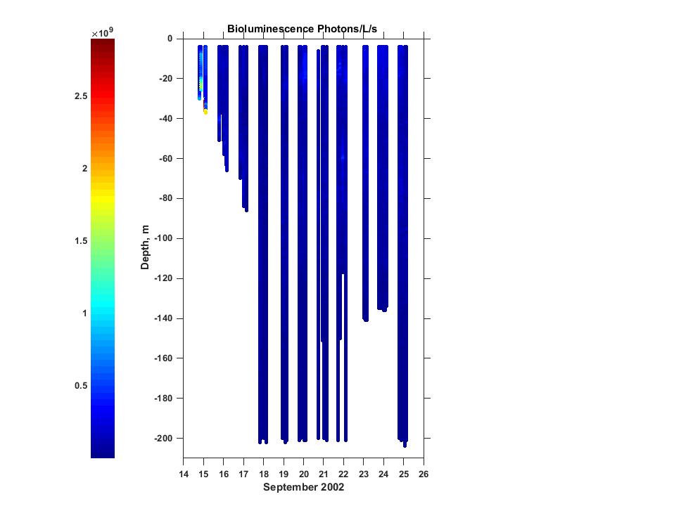
12 Adriatic Sea 12

13 Arabian Gulf Data Collection 13
14 Correlation Values in Vertical Domain Jun 1993 AG Jun 1993 GOO Mar 1996 AG Mar 1996 GOO Jun 2000 AG Jun 2000 GOO Sep 2000 AG Sep 2000 GOO Temp Salinity Temp Biolum Temp Fluor Temp %RTr Temp %BTr Biolum Fluor Biolum %RTr Biolum %Btr Fluor %RTr Fluor %Btr
15 Correlation of Derived Parameters Jun 1993 AG Jun 1993 GOO Mar 1996 AG Mar 1996 GOO Jun 2000 AG Jun 2000 GOO Sep 2000 AG Sep 2000 GOO FluorPeak BiolPeak FluorPeak Fluor50% FluorPeak Fluor90% 0.8 FluorPeak Biol50% FluorPeak Biol90% FluorPeak RedBA peak FluorPeak BlueBA peak FluorPeak EZD
16 Future Work Glider data analysis 10,000+ profiles over a 6 year period Different optical sensor Ability to get scaling value from backscatter (Glider) to transmission (HIDEX) High resolution classified data analysis Global data set enroute from NAVOCEANO 16
17 Thesis Plans Effects of Varying Oceanographic Conditions in the Arabian Gulf on Underwater Optical Communications and Detection by LT Ross Hammerer, Mar 2016 Effects of Varying Oceanographic Conditions in the Adriatic Sea on Underwater Optical Communications and Detection by LCDR Alec Cullen, June 2016 Effects of Varying Oceanographic Conditions in the East Asian Marginal Seas on Underwater Optical Communications and Detection by LCDR Brian Breshears, June
18 Questions? Excellence Through Knowledge
Author(s) Martinez, Ramon P. Title warfare using SEAGLIDER data. Monterey, California: Naval Postgraduate Sc. Issue Date
 Martinez, Ramon P. Title warfare using SEAGLIDER data. Monterey, California: Naval Postgraduate Sc. Issue Date") Author(s) Martinez, Ramon P. Title Bio optical and hydrographic characteristic warfare using SEAGLIDER data Publisher Monterey, California: Naval Postgraduate Sc Issue Date 2014 12 URL http://hdl.handle.net/10945/44612
Author(s) Martinez, Ramon P. Title Bio optical and hydrographic characteristic warfare using SEAGLIDER data Publisher Monterey, California: Naval Postgraduate Sc Issue Date 2014 12 URL http://hdl.handle.net/10945/44612
COMPARISON OF FIXED & VARIABLE RATES (25 YEARS) CHARTERED BANK ADMINISTERED INTEREST RATES - PRIME BUSINESS*
 CHARTERED BANK ADMINISTERED INTEREST RATES - PRIME BUSINESS*") COMPARISON OF FIXED & VARIABLE RATES (25 YEARS) Fixed Rates Variable Rates FIXED RATES OF THE PAST 25 YEARS AVERAGE RESIDENTIAL MORTGAGE LENDING RATE - 5 YEAR* (Per cent) Year Jan Feb Mar Apr May Jun Jul
COMPARISON OF FIXED & VARIABLE RATES (25 YEARS) Fixed Rates Variable Rates FIXED RATES OF THE PAST 25 YEARS AVERAGE RESIDENTIAL MORTGAGE LENDING RATE - 5 YEAR* (Per cent) Year Jan Feb Mar Apr May Jun Jul
Seasonal Circulation in the Yellow and the East China Seas driven by the monsoon winds
 Seasonal Circulation in the Yellow and the East China Seas driven by the monsoon winds Ig-Chan Pang 1 and Jae-Hong Moon 2 1 : Cheju National University 2 : Department of Earth System Science and Technology,
MAPCO2 Buoy Metadata Report Project Title:
 MAPCO2 Buoy Metadata Report Project Title: Autonomous Multi-parameter Measurements from a Drifting Buoy During the SO GasEx Experiment Funding Agency: NOAA Global Carbon Cycle program PI(s): Christopher
Deep SOLO. Nathalie Zilberman, Dean Roemmich, and SIO float lab. 1. Deep SOLO float characteristics. 2. Deep SOLO float Deployment
 Deep SOLO Nathalie Zilberman, Dean Roemmich, and SIO float lab 1. Deep SOLO float characteristics 2. Deep SOLO float Deployment 3. Deep SOLO temperature and salinity Deep SOLO Float deployment, R/V Tangaroa
Application for Consent to Conduct Marine Scientific Research. F Internal Waves in Straits (IWISE) Institution Contact Information Director
 Institution Contact Information Director") 1. General Information 1.1 Reference ID: Application for Consent to Conduct Marine Scientific Research Application number: Project name: F2010-111 Internal Waves in Straits (IWISE) 1.2 Sponsoring institution(s):
1. General Information 1.1 Reference ID: Application for Consent to Conduct Marine Scientific Research Application number: Project name: F2010-111 Internal Waves in Straits (IWISE) 1.2 Sponsoring institution(s):
RR10106 Cruise Plan ITOP Mooring Recovery and PhilSea10 Seaglider Operation (R/V Revelle November 6-26, 2010)
") RR10106 Cruise Plan ITOP Mooring Recovery and PhilSea10 Seaglider Operation (R/V Revelle November 6-26, 2010) Chief Scientist: Ren-Chieh Lien, Applied Physics Lab, University of Washington Co-Chief Scientist:
RR10106 Cruise Plan ITOP Mooring Recovery and PhilSea10 Seaglider Operation (R/V Revelle November 6-26, 2010) Chief Scientist: Ren-Chieh Lien, Applied Physics Lab, University of Washington Co-Chief Scientist:
Fine-Scale Survey of Right and Humpback Whale Prey Abundance and Distribution
 DISTRIBUTION STATEMENT A. Approved for public release; distribution is unlimited. Fine-Scale Survey of Right and Humpback Whale Prey Abundance and Distribution Joseph D. Warren School of Marine and Atmospheric
Application for Consent to Conduct Marine Scientific Research in Japan. Date: 18 December 2009 Revised 1/7/ General Information
 Application for Consent to Conduct Marine Scientific Research in Japan Date: 18 December 2009 Revised 1/7/10 1. General Information 1.1 Project name and/or #: Impact of Typhoons on the Pacific: Glider
Boost Your Skills with On-Site Courses Tailored to Your Needs
 Boost Your Skills with On-Site Courses Tailored to Your Needs www.aticourses.com The Applied Technology Institute specializes in training programs for technical professionals. Our courses keep you current
Quality control of data streams at ANFOG
 Quality control of data streams at ANFOG Christine Hanson & Claire Gourcuff Australian National Facility for Ocean Gliders (ANFOG), School of Environmental Systems Engineering (SESE) and UWA Oceans Institute
Applications of Collected Data from Argos Drifter, NOAA Satellite Tracked Buoy in the East Sea
 Applications of Collected Data from Argos Drifter, NOAA Satellite Tracked Buoy in the East Sea Young-Sang Suh (yssuh@nfrdi.re.kr) Ocean Research Team, National Fisheries Research and Development Institute,
WEBB RESEARCH CORPORATION
 Use spacebar or arrow keys to advance slide show WEBB RESEARCH CORPORATION Falmouth, MA APEX Profiler SLOCUM Glider Rev: 06/22/08 WEBB RESEARCH CORPORATION Specialists in neutrally buoyant drifters and
How well do CMIP5 climate models reproduce Southern Ocean bottom temperature? Model climatology
 How well do CMIP5 climate models reproduce Southern Ocean bottom temperature? Model climatology (colours) plus August (dashed) & February (solid) sea ice edge. Heuzé et al. (2013, GRL) Autosub autonomous
FIU Digital Commons. Florida International University. Henry O. Briceño Florida International University,
 Florida International University FIU Digital Commons SERC Research Reports Southeast Environmental Research Center 2015 Water Quality Monitoring Project for Demonstration of Canal Remediation Methods Florida
Temperature, salinity, density, and the oceanic pressure field
 Chapter 2 Temperature, salinity, density, and the oceanic pressure field The ratios of the many components which make up the salt in the ocean are remarkably constant, and salinity, the total salt content
Autonomous Environmental Profiling Moorings for Coastal Monitoring
 Autonomous Environmental Profiling Moorings for Coastal Monitoring Jeffrey W. Book Naval Research Laboratory, Stennis Space Center, MS Introduction There are many reasons to monitor coastal environments
Vertical in situ profiles of nitrate and oxygen in the northern Japan Sea
 Vertical in situ profiles of nitrate and oxygen in the northern Japan Sea Dmitry D. Kaplunenko, Vyacheslav B. Lobanov, Pavel Ya. Tishchenko and Maria G. Shvetsova V.I.Il'ichev Pacific Oceanological Institute,
Wind Data Verification Report Arriga 50m
 Page 1 of 11 Site Name Site Details 9531 - Arriga 5m Arriga 5m Date/Time of report generation 27/11/212 4:22 PM Site Number 9531 Mast Height 5m Mast Location 32568 E 811256 N Coordinate System UTM 55K
Draft of OKMC Cruise Plan (R/V Revelle June 1-14, 2012 RR1205)
") Draft of OKMC Cruise Plan (R/V Revelle June 1-14, 2012 RR1205) Ren-Chieh Lien and Thomas B Sanford 1. Objectives In the RR1205 cruise, we will deploy five subsurface moorings, one surface mooring (TBD),
Draft of OKMC Cruise Plan (R/V Revelle June 1-14, 2012 RR1205) Ren-Chieh Lien and Thomas B Sanford 1. Objectives In the RR1205 cruise, we will deploy five subsurface moorings, one surface mooring (TBD),
Sensor Stability. Summarized by Breck Owens David Murphy, Sea-Bird Electronics AST-14 Wellington March 18-21
 Sensor Stability Summarized by Breck Owens David Murphy, Sea-Bird Electronics AST-14 Wellington March 18-21 Physical Standards are the Foundation of Temperature Accuracy Standards grade platinum thermometer
Properties. terc.ucdavis.edu 8
 Physical Properties 8 Lake surface level Daily since 1900 The lowest lake level on record was 6,220.26 feet on Nov. 30, 1992. Since 1900, lake level has varied by more than 10 feet. Lake level typically
Payload CTD. Carol D. Janzen 1 Research and Development 1 Sea-Bird Electronics, Inc. Elizabeth L. Creed 2 MaritimeSystems 2 irobot Corporation
 Physical Oceanographic Data from Seaglider Trials in Stratified Coastal Waters Using a New Pumped Payload CTD Carol D. Janzen 1 Research and Development 1 Sea-Bird Electronics, Inc. Bellevue, WA, USA cjanzen@seabird.com
7.4 Temperature, Salinity and Currents in Jamaica Bay
 7.4 Temperature, Salinity and Currents in Jamaica Bay Arnold Gordon, Bruce Huber and Robert Houghton 7.4.1 INTRODUCTION Jamaica Bay stratification is weakly indicative of a shallow, tidally active environment,
Columbia River Plume 2006 OSU Ocean Mixing Nash, Kilcher, Moum et al. CR05 Cruise Report (RISE Pt. Sur, May )
") CR05 Cruise Report (RISE Pt. Sur, May 21-31 2006) Group Summary: Participants: Pt. Sur Ocean Mixing Group: Jonathan Nash, Levi Kilcher, Alexander Perlin, Greg Avicola; Pt. Sur UW: Emily Spahn (Alex Horner-Devine;
CR05 Cruise Report (RISE Pt. Sur, May 21-31 2006) Group Summary: Participants: Pt. Sur Ocean Mixing Group: Jonathan Nash, Levi Kilcher, Alexander Perlin, Greg Avicola; Pt. Sur UW: Emily Spahn (Alex Horner-Devine;
Application for Consent to Conduct Marine Scientific Research in Areas Under National Jurisdiction of. Philippines
 Date: July 29, 2008 Application for Consent to Conduct Marine Scientific Research in Areas Under National Jurisdiction of Philippines 1. General Information 1.1 Cruise name and/or #: Philippine Archipelago
Variability in the tropical oceans - Monitoring and prediction of El Niño and La Niña -
 Variability in the tropical oceans - Monitoring and prediction of El Niño and La Niña - Jun ichi HIROSAWA Climate Prediction Division Japan Meteorological Agency SST anomaly in Nov. 1997 1 ( ) Outline
PERSPECTIVES FOR ACCURACY AND QUALITY ASSURANCE OF CTD & BIOGEOCHEMICAL DATA STREAMS FROM AUTONOMOUS PLATFORMS
 PERSPECTIVES FOR ACCURACY AND QUALITY ASSURANCE OF CTD & BIOGEOCHEMICAL DATA STREAMS FROM AUTONOMOUS PLATFORMS Ian D. Walsh (1), Jochen Klinke (2), Kim Martini (3), David Murphy (4) (1) Sea-Bird Scientific,
Examples of Carter Corrected DBDB-V Applied to Acoustic Propagation Modeling
 Naval Research Laboratory Stennis Space Center, MS 39529-5004 NRL/MR/7182--08-9100 Examples of Carter Corrected DBDB-V Applied to Acoustic Propagation Modeling J. Paquin Fabre Acoustic Simulation, Measurements,
3 The monsoon currents in an OGCM
 3 The monsoon currents in an OGCM The observations show that both Ekman drift and geostrophy contribute to the surface circulation in the north Indian Ocean. The former decays rapidly with depth, but the
Procedures for correcting in situ CTD data and results obtained during the NEAR-GOOS Cross-Basin Climate Monitoring Section project
 Procedures for correcting in situ CTD data and results obtained during the NEAR-GOOS Cross-Basin Climate Monitoring Section project Dmitry Kaplunenko 1, Aleksander Lazaryuk 1, 2, Vyacheslav Lobanov 1,
An Atlas of Oceanic Internal Solitary Waves (February 2004) by Global Ocean Associates Prepared for Office of Naval Research Code 322 PO
 by Global Ocean Associates Prepared for Office of Naval Research Code 322 PO") Overview The is located in the North Atlantic Ocean between southern Ireland and southwest England (Figure 1). The Sea s western edge covers a continental shelf region characterized by rough and irregular
Overview The is located in the North Atlantic Ocean between southern Ireland and southwest England (Figure 1). The Sea s western edge covers a continental shelf region characterized by rough and irregular
Lower Coquitlam River Project Water Use Plan. Temperature Monitoring Lower Coquitlam River Project Year 2 Report
 Lower Coquitlam River Project Water Use Plan Temperature Monitoring Lower Coquitlam River Project Year 2 Report COQMON#6 Temperature Monitoring Study Lower Coquitlam River Study Period: Year 2-2007 Report
Current observations at the Jan Mayen Ridge
 Current observations at the Jan Mayen Ridge Kjell Arne Mork 1, Ken Drinkwater 1, Steingrimur Jónsson 2, Hédinn Valdimarsson 2 1 Institute of Marine Research and Bjerknes Centre for Climate Research, Bergen,
3.6 Magnetic surveys. Sampling Time variations Gradiometers Processing. Sampling
 3.6 Magnetic surveys Sampling Time variations Gradiometers Processing Sampling Magnetic surveys can be taken along profiles or, more often, on a grid. The data for a grid is usually taken with fairly frequent
TRIAXYS Acoustic Doppler Current Profiler Comparison Study
 TRIAXYS Acoustic Doppler Current Profiler Comparison Study By Randolph Kashino, Axys Technologies Inc. Tony Ethier, Axys Technologies Inc. Reo Phillips, Axys Technologies Inc. February 2 Figure 1. Nortek
CRUISE REPORT FOR UW BERING STRAIT MOORING PROJECT 2005 Rebecca Woodgate, University of
 CRUISE REPORT FOR UW BERING STRAIT MOORING PROJECT 2005 Rebecca Woodgate, University of Washington,woodgate@apl.washington.edu CCGC Sir Wilfrid Laurier 2005-05 Kodiak, 8 th July 2005 Barrow, 22nd July
6 th Meeting of the Scientific Committee Puerto Varas, Chile, 9-14 September 2018
 6 th Meeting of the Scientific Committee Puerto Varas, Chile, 9-14 September 218 SC6-Doc24 China s Annual Report, part II (Jumbo squid) Gang Li, Bilin Liu, Luoliang Xu & Xinjun Chen Annual Report of China
WHOTS Mooring Subsurface Instrumentation
 UH Contributions to WHOTS-13 Cruise Report by Fernando Santiago-Mandujano, Daniel McCoy, Jefrey Snyder, R. Walter Deppe, Kellen Rosburg, Glenn Carter, Katrina Berry, and Roger Lukas WHOTS Mooring Subsurface
World Ocean Atlas (WOA) Product Documentation
 Product Documentation") World Ocean Atlas (WOA) Product Documentation This document describes WOA statistical and objectively analyzed field files. This description includes the types of statistical fields available, for which
World Ocean Atlas (WOA) Product Documentation This document describes WOA statistical and objectively analyzed field files. This description includes the types of statistical fields available, for which
Module 9. Advanced Data Processing
 Module 9 Advanced Data Processing 2 Module 9: Advanced Data processing Overview Advanced Data Processing or Why Doesn t My Data Look Like the Examples in Class? Sensor alignment, matching measurements
2018 HR & PAYROLL Deadlines
 th (by payment date) EPAF 3rd PARTY FEEDS WTE Approval 2018 HR & PAYROLL s Normal Payroll day s 2017 B1-26 3 * 13-Dec-17 15-Dec-17 n/a n/a n/a 28-Dec-17 29-Dec-17 11:00 AM 16-Dec-2017 29-Dec-2017 JAN 2018
Temperature, Salinity, Dissolved Oxygen and Water Masses of Vietnamese Waters
 Southeast Asian Fisheries Development Center Temperature, Salinity, Dissolved Oxygen and Water Masses of Vietnamese Waters Penjan Rojana-anawat, Siriporn Pradit, Natinee Sukramongkol and Somboon Siriraksophon
Utility Debt Securitization Authority 2013 T/TE Billed Revenues Tracking Report
 Utility Debt Securitization Authority 2013 T/TE Billed Revenues Tracking Report Billing Budgeted Billed Dollar Percent Month Revenues Revenues Variance Variance Jan 2018 11,943,180.68 12,697,662.47 754,481.79
The development of high resolution global ocean surface wave-tidecirculation
 PICES Annual Meeting in Qingdao The development of high resolution global ocean surface wave-tidecirculation coupled model Fangli Qiao, Qi Shu and Bin Xiao First Institute of Oceanography, SOA, China Oct
APPLICATION OF SOUND PROPAGATION (IN THE PERSIAN GULF AND OMAN SEA)
") APPLICATION OF SOUND PROPAGATION (IN THE PERSIAN GULF AND OMAN SEA) Seyed Majid Mosaddad Department of Physics, Shoushtar Branch, Islamic Azad University, Shoushtar, Iran Email: mosaddad5@gmail.com Abstract
APPLICATION OF SOUND PROPAGATION (IN THE PERSIAN GULF AND OMAN SEA) Seyed Majid Mosaddad Department of Physics, Shoushtar Branch, Islamic Azad University, Shoushtar, Iran Email: mosaddad5@gmail.com Abstract
Probing the subsurface ocean processes using ocean LIDARS
 Probing the subsurface ocean processes using ocean LIDARS Authors: Robert Arnone (1), Sergio Derada (1), Sherwin Ladner (1), and Charles Trees (2) (1) NRL, Oceanography Division, Stennis Space Center,
Sensors and Platforms for Autonomous Undersea Systems
 Sensors and Platforms for Autonomous Undersea Systems Robert C. Spindel Applied Physics Laboratory University of Washington 1013 NE 40 th Street Seattle, WA 98105 USA spindel@apl.washington.edu 206 543
In ocean evaluation of low frequency active sonar systems
 Acoustics 8 Paris In ocean evaluation of low frequency active sonar systems K.T. Hjelmervik and G.H. Sandsmark FFI, Postboks 5, 39 Horten, Norway kth@ffi.no 2839 Acoustics 8 Paris Sonar performance measurements
Bluetongue Disease (BT)
") Bluetongue Disease (BT) Analysis of ADNS data since 01/2018 Reporting period: 2018-01-01 2018-12-09 Data query: 2018-12-10 AGES DSR Austrian Agency for Health and Food Safety www.ages.at Parameters Data
Bluetongue Disease (BT) Analysis of ADNS data since 01/2018 Reporting period: 2018-01-01 2018-12-09 Data query: 2018-12-10 AGES DSR Austrian Agency for Health and Food Safety www.ages.at Parameters Data
Overview. 2 Module 13: Advanced Data Processing
 2 Module 13: Advanced Data Processing Overview This section of the course covers advanced data processing when profiling. We will discuss the removal of the fairly gross effects of ship heave and talk
Effect of Suspended Sediment on Acoustic Detection Using Reverberation
 TECHNICAL NOTE Effect of Suspended Sediment on Acoustic Detection Using Reverberation AUTHORS Peter C. Chu Michael Cornelius Naval Ocean Analysis and Prediction Laboratory Department of Oceanography Naval
A Diver-Operated Optical and Physical Profiling System
 1421 A Diver-Operated Optical and Physical Profiling System J. RONALD V. ZANEVELD AND EMMANUEL BOSS School of Oceanic and Atmospheric Sciences, Oregon State University, Corvallis, Oregon CASEY M. MOORE
Cascading of Dense Water along the Peter the Great Bay Slope in the northwestern Japan Sea
 PICES-2014 Annual Meeting, POC Papers, October 24, 2014, Yeosu, Korea Cascading of Dense Water along the Peter the Great Bay Slope in the northwestern Japan Sea V.Lobanov, A.Sergeev, I.Gorin, P.Scherbinin,
Annual Measurement of Solar UVB at a Reef Site Using a Polyphenylene Oxide Dosimeter
 Annual Measurement of Solar UVB at a Reef Site Using a Polyphenylene Oxide Dosimeter Alfio Parisi, Nathan Downs, Peter Schouten parisi@usq.edu.au University of Southern Queensland, Toowoomba, Australia
Impacts of climate change on the distribution of blue marlin (Makaira. nigricans) ) as inferred from data for longline fisheries in the Pacific Ocean
 ) as inferred from data for longline fisheries in the Pacific Ocean") Impacts of climate change on the distribution of blue marlin (Makaira nigricans) ) as inferred from data for longline fisheries in the Pacific Ocean Nan-Jay Su 1*, Chi-Lu Sun 1, Andre Punt 2, Su-Zan Yeh
Impacts of climate change on the distribution of blue marlin (Makaira nigricans) ) as inferred from data for longline fisheries in the Pacific Ocean Nan-Jay Su 1*, Chi-Lu Sun 1, Andre Punt 2, Su-Zan Yeh
Determination Of Nearshore Wave Conditions And Bathymetry From X-Band Radar Systems
 Determination Of Nearshore Wave Conditions And Bathymetry From X-Band Radar Systems Okey G. Nwogu Dept. of Naval Architecture and Marine Engineering University of Michigan Ann Arbor, MI 489 phone: (734)
Accuracy and Stability of Sea-Bird s Argo CTD and Work Towards a Better CTD for Deep Argo. David Murphy Sea-Bird Electronics
 Accuracy and Stability of Sea-Bird s Argo CTD and Work Towards a Better CTD for Deep Argo David Murphy Sea-Bird Electronics The Sea-Bird Team This work represents efforts of many people over many years:
R/V Point Sur Pre-Cruise Questionnaire
 R/V Point Sur Pre-Cruise Questionnaire Please fill this out and return at least 40 days prior to your cruise to ensure that all of your technical needs can be met BASIC INFO Purpose of Cruise: Submitter's
"Real-Time Vertical Temperature, and Velocity Profiles from a Wave Glider"
 DISTRIBUTION STATEMENT A. Approved for public release; distribution is unlimited. "Real-Time Vertical Temperature, and Velocity Profiles from a Wave Glider" Luca Centurioni Scripps Institution of Oceanography
(Sea)glider data processing the. sampling and thermal lag
glider data processing the. sampling and thermal lag") (Sea)glider data processing the issues of multi parameter serial data sampling and thermal lag Sunke Schmidtko University of East Anglia s.schmidtko@uea.ac.uk (Gerd Krahmann, Pierre Testor, Tomeu Garau,
(Sea)glider data processing the issues of multi parameter serial data sampling and thermal lag Sunke Schmidtko University of East Anglia s.schmidtko@uea.ac.uk (Gerd Krahmann, Pierre Testor, Tomeu Garau,
SEAHORSES and SUBMARINES Testing transformational capabilities with modern UUVs at NAVOCEANO by Craig A. Peterson and Martha E. M.
 SEAHORSE engineers work on a module inside one AUV of the SEAHORSE 2 bays. SEAHORSE 2 is being prepared for launch from the IC-508 AUV Support Vessel. SEAHORSES and SUBMARINES Testing transformational
Imprints of Coastal Mountains on Ocean Circulation and Variability
 Imprints of Coastal Mountains on Ocean Circulation and Variability Shang-Ping Xie 1 with C.-H. Chang 1, W. Zhuang 2, N. Schneider 1, J. Small 3, B. Taguchi 4, and H. Sasaki 4 1 IPRC, University of Hawaii
Sound production in mysticetes. Background. Cetacean vocal frequency ranges Dolphins
 Sound production in mysticetes Fish 475 - May 4 2007 Background Cetaceans produce sound in the widest range of frequencies for any Class of animal Subsonic to supersonic and everywhere in between Sound
Geostrophic and Tidal Currents in the South China Sea, Area III: West Philippines
 Southeast Asian Fisheries Development Center Geostrophic and Tidal Currents in the South China Sea, Area III: West Philippines Anond Snidvongs Department od Marine Science, Chulalongkorn University, Bangkok
System Flexibility Indicators
 System Flexibility Indicators Place your chosen image here. The four corners must just cover the arrow tips. For covers, the three pictures should be the same size and in a straight line. Operational Forum
EcoElectrica s 2016 Biological Monitoring Plan and Outreach Report
 EcoElectrica s 2016 Biological Monitoring Plan and Outreach Report Luis R. Rodríguez Matos Ernesto Otero Rosamar Ayala UPRM-Mayagüez Summary Monthly Water Quality Sampling Continuous Water Quality Monitoring
The Next Generation Easy-to-Deploy (ETD) Tsunami Assessment Buoy
 Tsunami Assessment Buoy") The Next Generation Easy-to-Deploy (ETD) Tsunami Assessment Buoy R.A. Lawson and D. Graham Science Applications International Corporation 4025 Hancock Street San Diego, CA 92110 USA S. Stalin, C. Meinig,
The Next Generation Easy-to-Deploy (ETD) Tsunami Assessment Buoy R.A. Lawson and D. Graham Science Applications International Corporation 4025 Hancock Street San Diego, CA 92110 USA S. Stalin, C. Meinig,
Site Description: LOCATION DETAILS Report Prepared By: Tower Site Report Date
 Wind Resource Summary for Holyoke Site Final Report Colorado Anemometer Loan Program Monitoring Period:: 6/21/26 /6/27 Report Date: December 2, 27 Site Description: The site is 17.4 miles south of the
NOTE ->->-> DUE THURSDAY APRIL 20 TH 2006 THAT IS CORRECT I FORGOT THIS IS EASTER WEEKEND SO I HAVE EXTENDED THE DUE DATE TO THE ABOVE
 GEO 130 NAME OCEANOGRAPHY TEST 3 TAKE HOME TEST SPRING 2006 NOTE ->->-> DUE THURSDAY APRIL 20 TH 2006 THAT IS CORRECT I FORGOT THIS IS EASTER WEEKEND SO I HAVE EXTENDED THE DUE DATE TO THE ABOVE This test
Drift Characteristics of Paroscientific pressure sensors
 Drift Characteristics of Paroscientific pressure sensors by Randolph Watts, Maureen Kennelly, Karen Tracey, and Kathleen Donohue (University of Rhode Island) PIES + current meter & CPIES arrays Paroscientific
Suburb Flyover Report
 Suburb Flyover Report NARRABEEN (House) Prepared By: Shelley Bakhuizen, Ray White Mona Vale NARRABEEN - Suburb Map NARRABEEN - Sales Statistics (Houses) Year # Sales Median Growth Low High 1998 188 $ 09,500
Coquitlam/Buntzen Project Water Use Plan
 Coquitlam/Buntzen Project Water Use Plan Temperature Monitoring Lower Coquitlam River Project Year 3 Report Reference: COQMON#6 Study Period: March 2008 April 2009 Report Date: April 2009 Trow Associates
An Atlas of Oceanic Internal Solitary Waves (February 2004) by Global Ocean Associates Prepared for Office of Naval Research Code 322 PO
 by Global Ocean Associates Prepared for Office of Naval Research Code 322 PO") Overview covers approximately 2200 km of coast from Kenya to the tip of Somalia (approximately 39 o E, 4 o S to 51 o E, 12 o N)(Figure 1). Internal wave activity has been observed in the area the near
Overview covers approximately 2200 km of coast from Kenya to the tip of Somalia (approximately 39 o E, 4 o S to 51 o E, 12 o N)(Figure 1). Internal wave activity has been observed in the area the near
Axial Base (PN3A) Medium-Power (MP) J-box
 Medium-Power (MP) J-box") Axial Base (PN3A) Medium-Power (MP) J-box Location: 46.1 N, 129.6 W Depth of Water Column: 2654 m This node supports geophysical instruments at the base of Axial Seamount. Instrument Name/Description Data
Axial Base (PN3A) Medium-Power (MP) J-box Location: 46.1 N, 129.6 W Depth of Water Column: 2654 m This node supports geophysical instruments at the base of Axial Seamount. Instrument Name/Description Data
QC for Hydrographic Data GEOSECS to GO-SHIP. Susan M. Becker Scripps Institution of Oceanography Oceanographic Data Facility
 QC for Hydrographic Data GEOSECS to GO-SHIP Susan M. Becker Scripps Institution of Oceanography Oceanographic Data Facility Global Hydrographic Efforts Geo-chemical Ocean Sections (GEOSECS) World Ocean
84 N 83 N 82 N 81 N 80 N 79 N 78 N 77 N 76 N 75 N. Resolute 74 N 96 W 92 W. Hydrographic Stations Cruise Jul - 11 Aug W
 Processing SBE9 Data IOS Expedition 2003-35 Project This expedition was the result of DFO collaboration (Dr H Melling) with Oregon State University (Dr. Kelly Falkner and University of Delaware (Dr Andreas
CTD General Practices: System Description, Deployment, Data Acquisition, & Maintenance
 CTD General Practices: System Description, Deployment, Data Acquisition, & Maintenance SUMMARY: Since 1993, the CalCOFI program has deployed a Seabird 911 CTD mounted on a 24-bottle rosette during seasonal,
Walker Circulation and El Niño / La Niña Sea Surface Temperature, Rainfall, and Zonal Wind
 Walker Circulation and El Niño / La Niña Sea Surface Temperature, Rainfall, and Zonal Wind David Halpern NASA / California Institute of Technology Jet Propulsion Laboratory Pasadena, CA 91109, USA Contents
Wind Resource Assessment for NOME (ANVIL MOUNTAIN), ALASKA Date last modified: 5/22/06 Compiled by: Cliff Dolchok
, ALASKA Date last modified: 5/22/06 Compiled by: Cliff Dolchok") 813 W. Northern Lights Blvd. Anchorage, AK 99503 Phone: 907-269-3000 Fax: 907-269-3044 www.akenergyauthority.org SITE SUMMARY Wind Resource Assessment for NOME (ANVIL MOUNTAIN), ALASKA Date last modified:
813 W. Northern Lights Blvd. Anchorage, AK 99503 Phone: 907-269-3000 Fax: 907-269-3044 www.akenergyauthority.org SITE SUMMARY Wind Resource Assessment for NOME (ANVIL MOUNTAIN), ALASKA Date last modified:
Robin J. Beaman. School of Earth and Environmental Sciences, James Cook University, Cairns, Qld 4870, Australia.
 Robin J. Beaman School of Earth and Environmental Sciences, James Cook University, Cairns, Qld 4870, Australia. Email: robin.beaman@jcu.edu.au Seminar to SSSI Qld Hydrography Coping with Nature, Brisbane,
Site Description: Tower Site
 Wind Resource Summary for Elizabeth Site Final Report Colorado Anemometer Loan Program Monitoring Period: 7/3/6 /15/7 Report Date: December 22, 7 Site Description: The site is.6 miles northeast of the
Final Report. Lead PI: EMMANUEL BOSS (UNIVERSITY OF MAINE)
") DEVELOPMENT, ASSESSMENT, AND COMMERCIALIZATION OF A BIOGEOCHEMICAL PROFILING FLOAT FOR CALIBRATION AND VALIDATION OF OCEAN COLOR AND OCEAN CARBON STUDIES Final Report Lead PI: EMMANUEL BOSS (UNIVERSITY
DEVELOPMENT, ASSESSMENT, AND COMMERCIALIZATION OF A BIOGEOCHEMICAL PROFILING FLOAT FOR CALIBRATION AND VALIDATION OF OCEAN COLOR AND OCEAN CARBON STUDIES Final Report Lead PI: EMMANUEL BOSS (UNIVERSITY
Sei Ichi SAITOH 1, 2 Robinson M. Mugo 1,3,
 Sei Ichi SAITOH 1, 2 Robinson M. Mugo 1,3, Mukti Zainuddin 4 and Fumihiro Takahashi 2 ssaitoh@salmon.fish.hokudai.ac.jp 1 Faculty of Fisheries Sciences. Hokkaido University 2 Green & Life Innovation, Inc.
14/10/2013' Bathymetric Survey. egm502 seafloor mapping
 egm502 seafloor mapping lecture 10 single-beam echo-sounders Bathymetric Survey Bathymetry is the measurement of water depths - bathymetry is the underwater equivalent of terrestrial topography. A transect
2017 Float and Sensor Workshop. Conveners: Brian King, Steve Riser, Susan Wijffels Local Host: Steve Riser, U. Washington
 2017 Float and Sensor Workshop Conveners: Brian King, Steve Riser, Susan Wijffels Local Host: Steve Riser, U. Washington Objectives The goals of the workshop were to Increase the overall efficiency of
High Ping Rate Profile Water Mode 12
 Application Note FSA-014 (October 2008) Revised October 2008 High Ping Rate Profile Water Mode 12 Introduction Water Mode 12 is the result of the continued evolution of the signal processing within our
DEPARTMENT OF THE NAVY DIVISION NEWPORT OFFICE OF COUNSEL PHONE: FAX: DSN:
 IMAVSBA WARFARE CENTERS NEWPORT DEPARTMENT OF THE NAVY NAVAL UNDERSEA WARFARE CENTER DIVISION NEWPORT OFFICE OF COUNSEL PHONE: 401 832-3653 FAX: 401 832-4432 DSN: 432-3653 Attorney Docket No. 85031 Date:
Potential applications of AUVs and Gliders in Offshore Windfarm Site Surveys
 Potential applications of AUVs and Gliders in Offshore Windfarm Site Surveys Dr James Hunt (National Oceanography Centre, Southampton) MREKE Internship in partnership with MARS at NOCS Introduction to
Acoustic tagging: abundance indices and habitat use Juvenile southern bluefin tuna in Western Australia
 Acoustic tagging: abundance indices and habitat use Juvenile southern bluefin tuna in Western Australia Alistair Hobday, Ryo Kawabe, Ko Fujioka, Tomoyuki Itoh, Kazu Miyashita, Yoshimi Takao Recruitment
windnavigator Site Analyst Report
 windnavigator Site Analyst Report for Central NY Created for Stephen Meister April 27, 2010 ID NUMBER: N2-128 AWS Truepower, LLC Albany - Barcelona - Bangalore p: +1.518.21.00 e: info@awstruepower.com
An Atlas of Oceanic Internal Solitary Waves (February 2004) by Global Ocean Associates Prepared for Office of Naval Research Code 322 PO
 by Global Ocean Associates Prepared for Office of Naval Research Code 322 PO") Overview covers approximately 5500 km of coast between Western Sahara (22 o N, 17 o W) and Angola (5 o S, 12 o E) (Figure 1). The continental shelf in the region varies significantly in width. The region
Overview covers approximately 5500 km of coast between Western Sahara (22 o N, 17 o W) and Angola (5 o S, 12 o E) (Figure 1). The continental shelf in the region varies significantly in width. The region
Foreign overnights in the Nordic countries 2015
 Foreign overnights in the Nordic countries 2015 Sources: Statistics Statistics Statistics Statistics July 2016 VISIT FINLAND STATISTICS Contents Foreign overnights in the Nordic countries.4 Overnights
Naval Postgraduate School, Operational Oceanography and Meteorology. Since inputs from UDAS are continuously used in projects at the Naval
 How Accurate are UDAS True Winds? Charles L Williams, LT USN September 5, 2006 Naval Postgraduate School, Operational Oceanography and Meteorology Abstract Since inputs from UDAS are continuously used
Design Criteria Data
 TUCUMCARI NM Latitude = 35.18 N WMO No. 723676 Longitude =13.6 W Elevation = 465 feet Period of Record = 1973 to 1996 Average Pressure = 25.86 inches Hg Design Criteria Data Mean Coincident (Average) Values
An Atlas of Oceanic Internal Solitary Waves (February 2004) by Global Ocean Associates Prepared for Office of Naval Research Code 322 PO
 by Global Ocean Associates Prepared for Office of Naval Research Code 322 PO") Overview The is located in the western Pacific Ocean north of the Indonesian Island of Celebes and south of the Sulu Sea and the Philippines (Figure 1). It is a deep-water sea, roughly circular with several
Overview The is located in the western Pacific Ocean north of the Indonesian Island of Celebes and south of the Sulu Sea and the Philippines (Figure 1). It is a deep-water sea, roughly circular with several
Australian Northwest Shelf
 Overview The Australian Northwest shelf extends roughly 2000 km along the coast of Western Australia (Figure 1). The region is influenced by part of the South Equatorial Current that runs southwest out
Floats in Polar Oceans. Olaf Boebel and Eberhard Fahrbach, AWI-Bremerhaven, Germany
 Floats in Polar Oceans Olaf Boebel and Eberhard Fahrbach, AWI-Bremerhaven, Germany Floats in Polar Oceans: Strategy Development of a system for bipolar use in the Antarctic because of easier conditions:
Estimation of polluted area in case of potential leakage of the chemical munitions
 Estimation of polluted area in case of potential leakage of the chemical munitions Jaromir Jakacki Institute of Oceanology PAS, Sopot, Poland Science for the Environment 2015 ENVIRONMENTAL MONITORING AND
PRELIMINARY CRUISE REPORT, W9909C R/V WECOMA, September 1999 GLOBEC/ENSO Long-Term Observations off Oregon
 Submitted by Jane Fleischbein College of Oceanic & Atmospheric Sciences Oregon State University Corvallis, Oregon 97331-553 flei@oce.orst.edu, 541.737.5698 FILING DATE: 1 October 1999 PRELIMINARY CRUISE