No JULY 2012 UNITED STATES OF AMERICA. Contents
|
|
|
- Calvin Bates
- 5 years ago
- Views:
Transcription


1 30 28 JULY 2012 UNITED STATES OF AMERICA Published Weekly by the National Geospatial-Intelligence Agency Prepared Jointly with the National Ocean Service and U.S. Coast Guard Contents Section I Chart Corrections I-1.1 Chartlets / Depth Tabulations / Notes I-2.1 Charts Affected by Notice to Mariners I-3.1 Section II NGA/DLIS Catalog Corrections II-1.1 Navigation Publications Corrections II-2.1 USCG Light List Corrections / Radiobeacon Corrections II-3.1 NGA List of Lights / Radiobeacon / DGPS Corrections II-4.1 Publications Affected by Notice to Mariners II-5.1 Section III Broadcast Warnings / MARAD Advisories / Special Warnings III-1.1 Marine Information III-2.1 Visit the Maritime Safety Web site at
2 IMPORTANT INFORMATION The Notice to Mariners is published by the National Geospatial-Intelligence Agency (NGA), under the authority of Department of Defense Directive , to advise mariners of important matters affecting navigational safety, including new hydrographic discoveries, changes in channels and navigational aids, etc. (U.S. Code Title 10, Sec. 442 and Title 44, Sec refer). Nothing in the arrangement of information implies endorsement or acceptance by NGA in matters affecting the status and boundaries of States and territories. The Notice to Mariners presents corrective information affecting charts, NGA/DLIS Catalog of Maps Charts and Related Products, Coast Pilots, USCG Light Lists, NGA List of Lights and other products produced by the National Geospatial-Intelligence Agency, National Ocean Service and U.S. Coast Guard. Information for the Notice to Mariners is contributed by the following Agencies: National Geospatial-Intelligence Agency (NGA) (Department of Defense) for waters outside the territorial limits of the United States; National Ocean Service (NOS) (Department of Commerce), which is charged with the surveys and charting of the coasts and harbors of the United States and its territories; the U.S. Coast Guard (USCG) (Department of Homeland Security), which is responsible for the safety of life at sea and the establishment and operation of aids to navigation; and the U.S. Army Corps of Engineers (Department of Defense), which is charged with the improvement of rivers and harbors of the United States. In addition, important contributions are made by foreign hydrographic offices and cooperating observers of all nationalities. For further information concerning NGA hydrographic products and services, including the Maritime Safety Web site, users may contact: Name Telephone DSN FAX Maritime Safety Office N/A World Wide Navigational Warning Service Maritime Safety Web site N/A Notice to Mariners: Regions 1 and Notice to Mariners: Regions 3 thru Sailing Directions, Fleet Guides Navigation Publications DLA Catalog of Maps Charts and Related Products The Maritime Safety Web site can be accessed directly at For your convenience NGA provides four addresses. For information affecting Notice to Mariners use MCDNtM@nga.mil, for information affecting Sailing Directions and all other navigational publications use MCDPubs@nga.mil, for information concerning the Maritime Safety Web site, use webmaster_nss@nga.mil and for information concerning the World Wide Navigational Warning Service, use NavSafety@nga mil. Mariners are requested to notify NGA of discrepancies in charts and publications, using the Marine Information Report and Suggestion Sheet at the back of this Notice to Mariners. This form should also be used to report permanent changes, additions, or deletions from charted or published information. Reports which constitute an immediate hazard to navigation should be sent to the nearest NAVAREA Coordinator via coast radio stations. All reports are greatly appreciated. Marine Information Report and Suggestion sheets received during the past week were submitted by the following observers: Observer LTJG Aubrey Page Jonathan Eddy Jason Williamson Ship/Organization USS GETTYSBURG USNS SACAJAWEA RFA FORT ROSALIE Cover Photo: The NOAA Ship Fairweather, is a hydrographic survey ship that was originally commissioned in the National Oceanic and Atmospheric Administration (NOAA) fleet in 1968 and is named for Mt. Fairweather in southeast Alaska, which is the highest peak in the Fairweather Range--the tallest coastal range on earth. The ship was deactivated in 1989, but due to a critical backlog of survey requirements for nautical charts in the Alaska region, it was placed back into active service in The Fairweather is designed and outfitted primarily for conducting hydrographic surveys in support of nautical charting, but is capable of many other missions in support of NOAA programs. The ship is equipped with the latest in hydrographic survey technology--multi-beam survey systems; high-speed, high-resolution side-scan sonar; position and orientation systems, hydrographic survey launches, and an on-board data-processing server. Increased mission space and deck machinery enable Fairweather to be tasked with anything from buoy operations to fisheries research cruises. The 241 foot vessel is based in Ketchikan, Alaska and is NOAA's only multi-role Arctic survey platform. The bathymetric data collected by the ship is used to update critical chart areas in Alaska and the Arctic. The Fairweather is featured on the cover not only due to her invaluable survey collection capabilities and service to our nation, but also to recognize it as the last at-sea command of Rear Admiral Chris Andreasen, NOAA Corps (Ret) who is retiring after 50 years of service to the U.S. and international maritime community. RADM Andreasen has served in various capacities both afloat and ashore at NOAA, as the President of the Directing Committee for the International Hydrographic Organization (IHO), and most recently as the Chief Hydrographer of the National Geospatial-Intelligence Agency (NGA). His dedication, commitment and contributions to global safety of navigation throughout his career are unequalled and we wish him fair winds and following seas in his retirement! ii
3 INFORMATION OF SPECIAL INTEREST OR IMPORTANCE TO MARINERS NM 30/12 National Geospatial-Intelligence Agency Springfield, VA SPECIAL ANNOUNCEMENTS NEW PRODUCTS OR SERVICES IMPORTANT CHANGES 28 July 2012 MARAD ADVISORY THE MARITIME ADMINISTRATION HAS ISSUED MARAD ADVISORY 12-2 PROVIDING GUIDANCE TO VESSELS OPERATING IN THE GULF OF OMAN, NORTH ARABIAN SEA, GULF OF ADEN, AND BAB EL MANDEB. SEE SECTION III. NOAA CHART NEW EDITIONS AND THEIR AVAILABILITY NOAA RECOGNIZES TWO PAPER NAUTICAL CHART PRODUCTS: CHARTS-ON-DEMAND AND TRADITIONAL NOAA/NOS PAPER CHARTS. FOR ADDITIONAL INFORMATION, SEE SECTIONS II AND III. NEW EDITION OF COAST PILOT U.S. COAST PILOT 8, ALASKA, DIXON ENTRANCE TO CAPE SPENCER, THIRTY-FOURTH EDITION, 2012, IS READY FOR ISSUE. SEE SECTIONS II AND III. NGA CHART NEW EDITIONS AND THEIR AVAILABILITY NGA RECOGNIZES TWO PAPER NAUTICAL CHART PRODUCTS: ENTERPRISE PRODUCT ON DEMAND-MARITIME (EPOD-M) CHARTS AND TRADITIONAL NGA PAPER CHARTS. FOR ADDITIONAL INFORMATION, SEE SECTIONS II AND III. NGA DIGITAL NAUTICAL CHART NEW EDITIONS AND THEIR AVAILABILITY DIGITAL NAUTICAL CHART (DNC) NEW EDITIONS HAVE BEEN POSTED ON NGA MARITIME SAFETY WEBSITES. FOR ADDITIONAL INFORMATION, SEE SECTION III. NGA DIGITAL NAUTICAL PUBLICATIONS-QUARTERLY UPDATE THE DIGITAL NAUTICAL PUBLICATIONS-QUARTERLY UPDATE, SECOND QUARTER 2012, IS READY FOR ISSUE. THE DIGITAL NAUTICAL PUBLICATIONS-QUARTERLY UPDATE IS A LIMITED DISTRIBUTION PRODUCT AND IS PRODUCED BY NGA IN DIGITAL FORMAT ONLY. SEE SECTIONS II AND III. NATIONAL GEOSPATIAL-INTELLIGENCE AGENCY S IMPLEMENTATION OF A HARDCOPY TO DIGITAL TRANSITION STRATEGY THIS NOTICE IS A REMINDER OF THE NATIONAL GEOSPATIAL-INTELLIGENCE AGENCY (NGA) HARDCOPY TO DIGITAL TRANSITION PROGRAM. SEE SECTION III FOR DETAILS. iii
4 EXPLANATION OF CONTENTS The Notice to Mariners contains corrective information affecting nautical charts, the NGA/DLIS Catalog of Maps Charts and Related Products, Coast Pilots, USCG Light Lists, NGA List of Lights and other related nautical publications. The information contained in these corrections is important to safe navigation. It is the user s responsibility to decide which of their charts and publications require correction. Consult the U.S. Coast Guard Local Notice to Mariners for information pertaining to waterways within the United States that are not normally used by oceangoing vessels. Because of the sometimes transitory nature of aids to navigation, depths and port information, local area sources should be consulted whenever possible. This publication is not required to be maintained intact. Portions may be separated for correction or attachment to an affected product. The Notice to Mariners is divided into the following sections: Section I-1 contains corrections to nautical charts listed in numeric order by chart number. Each chart correction listed applies only to that particular chart. Related charts, if any, will have their own specific correction listed separately. Users should also refer to U.S. Chart 1 Nautical Chart Symbols, Abbreviations and Terms for additional information pertaining to the correcting of charts. The illustration below describes the elements that comprise a typical chart correction: International Series chart number U.S. Chart number Edition number Edition date Last Notice to Mariners that affected chart Current Notice to Mariners TP (INT 1234) 1Ed. 1/23/98 LAST NM 12/00 27/00 Add Depth 12 meters Obstn [K41] N E (12(345)00 Taunton) Corrective action Source of information Object of correction Chart 1 reference Position A chart correction preceded by: indicates that it is based upon original U.S. source information. T indicates that it is temporary in nature. P indicates that it is preliminary, and that permanent corrective action will appear in a future Notice to Mariners. The letter M immediately following the chart number indicates that the correction should be applied to the metric side of the chart only. The letter M is not a part of the chart number. The letter N preceding the current Notice to Mariners number indicates that the affected chart is on Limited Distribution and is normally only for use by U.S. Navy, government-owned or -chartered vessels. Courses and bearings are given in degrees true. Light sectors are expressed in degrees true from the vessel TOWARD the light. The visible range(s) listed for lights is normally the nominal range (the distance at which it can be seen in clear weather), expressed in nautical miles, except in the Great Lakes where it is expressed in statute miles. The colors of structures and lights of navigational aids are abbreviated in accordance with Chart 1. Section I-2* contains all chartlets, depth tabulations and notes associated with the chart corrections in Section I-1. Chartlets and depth tabulations supersede all previous information portrayed. Section I-3 lists all NGA and NOS charts which have been affected by Notice to Mariners and the notice numbers which have affected them since the date of the oldest Summary of Corrections or the chart s announcement, whichever is later. Section II-1 is a weekly listing of corrections to the NGA/DLIS Catalog of Maps Charts and Related Products, including new charts and publications. It also contains the latest price category information. Section II-2* contains corrections to navigation publications, including Coast Pilots, The American Practical Navigator, and other related nautical publications. Section II-3* lists weekly updates to the USCG Light Lists. Section II-4* lists weekly updates to the NGA List of Lights. Section II-5 lists all NGA, NOS and USCG navigation publications which have been affected by Notice to Mariners and the notice numbers which have affected them since the date of the publication s announcement. Section III-1 lists the message number of all in-force Navigational Warnings, and the text of those warnings promulgated during the previous week. Notice to Mariners Nos. 13, 26 and 39 list a summary of all in-force Navigational Warnings for the preceding quarter. Notice to Mariners 52 lists a complete summary of all in-force Navigational Warnings. Section III-2 contains miscellaneous information of particular interest to the maritime community. *The left-hand pages of these sections are intentionally blank. iv
5 SECTION I NM 30/12 CHART CORRECTIONS 120 6Ed. 8/20/94 LAST NM 43/11 30/12 Relocate Superbuoy ODAS from N63 30 W to N63 30 W (NTM0007/2012) Ed. 5/12 LAST NM 29/12 30/12 Add Submarine pipeline [L40.1] between N W N W Ed. 6/15/96 LAST NM 7/11 30/12 Relocate Superbuoy ODAS from N63 30 W to N63 30 W (NTM0007/2012) Ed. 4/6/85 LAST NM 27/12 30/12 Relocate Superbuoy ODAS from N63 30 W to N63 30 W (NTM0007/2012) (NOS) Submarine pipeline [L40.1] joining N W N W N W N W N W N W N W N W 400 (INT 400) 3Ed. 12/25/93 LAST NM 43/11 30/12 Relocate Superbuoy ODAS from N63 30 W to N63 30 W (NTM0007/2012) 402 (INT 402) 4Ed. 5/25/85 LAST NM 8/12 30/12 Relocate Superbuoy ODAS from N W to N W (NTM0007/2012) 1115A Ed. 10/10 LAST NM 29/12 30/12 Delete Submerged well (cov 35fms) and buoy N W (See 27/ A) (26/12 CG8) 1116A Ed. 5/12 LAST NM 29/12 30/12 Add Dashed-line circle Discol. water [Ke] (PA) N W Platform [L10] Danger circle Obstn [K40] (PA) (26, 27/12 CG8) N W N W Ed. 10/14/06 LAST NM 26/12 30/12 Add Dashed-line circle Discol. water [Ke] (PA) N W (26/12 CG8) Ed. 8/11 LAST NM 29/12 30/12 Relocate Light 47 from N W to N W Range light, front from N W to N W Note: Range bearing unchanged (26/12 CG8) Ed. 2/11 LAST NM 26/12 30/12 Add Lights (3) (Priv) N W (27/12 CG8) Ed. 5/08 LAST NM 19/12 30/12 (Side B) Add Lights (3) (Priv) N W (27/12 CG8) Ed. 12/09 LAST NM 29/12 30/12 Add Danger circle Obstn [K40] (PA) N W (27/12 CG8) Ed. 7/11 LAST NM 26/12 30/12 Substitute Submerged well [L20] (PA) for platform N W Note: Platform close S remains (26/12 CG8) Ed. 7/10 LAST NM 29/12 30/12 Add Submarine pipeline [L40.1] joining N W N W N W N W N W N W N W N W Platform [L10] N W Danger circle Obstn [K40] (PA) N W Platform [L10] (NOS; 26, 27/12 CG8) N W Ed. 10/10 LAST NM 29/12 30/12 Delete Submerged well (cov 35fms) and buoy N W (See 27/ ) (26/12 CG8) Ed. 9/24/05 LAST NM N29/12 N30/12 Delete Submerged well (cov 64m) and buoy N W (See N27/ ) (26/12 CG8) Ed. 5/12 LAST NM 29/12 30/12 Add Dashed-line circle Discol. water [Ke] (PA) N W Platform [L10] Danger circle Obstn [K40] (PA) (26, 27/12 CG8) N W N W Ed. 2/12 LAST NM 29/12 30/12 Add Lights (3) (Priv) N W (27/12 CG8) Ed. 7/11 LAST NM 26/12 30/12 Substitute Submerged well [L20] (PA) for platform N W Note: Platform close S remains (26/12 CG8) Ed. 1/12 LAST NM 27/12 30/12 Add Danger circle Obstn [K40] (PA) N W (26/12 CG8) Ed. 4/12 LAST NM 22/12 30/12 Add Lights (3) (Priv) N W (27/12 CG8) I-1.1
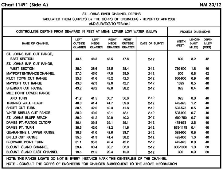
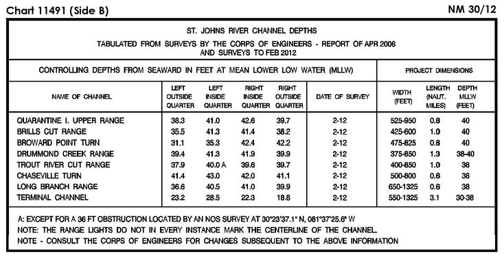
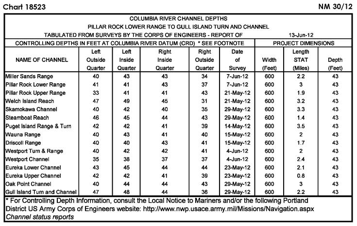
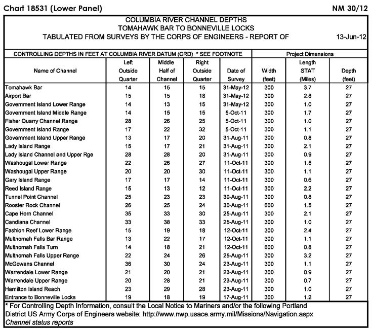
6 NM 30/12 SECTION I Ed. 12/09 LAST NM 50/11 30/12 (Side B) Add Submarine pipeline [L40.1] joining N W N W N W N W N W N W N W (NOS) Ed. 5/11 LAST NM 29/12 30/12 Delete Submerged well (cov 35fms) and buoy N W (Supersedes 27/ ) Add Danger circle Obstn [K40] (PA) N W (26, 27/12 CG8) Ed. 5/11 LAST NM 20/12 30/12 (Side B) Change Visibility (range) of light 44 to 5M N W (27/12 CG7) Ed. 1/11 LAST NM 28/12 30/12 (Upper Panel) Add Tabulation of controlling depths from Subsection I-2 (Supersedes 28/ ) (NOS) Ed. 5/10 LAST NM 28/12 30/12 (Side A) Change Legend to 29 FT FEB N W Ed. 3/12 LAST NM 18/12 30/12 Delete Buoy N W (26/12 CG1) Ed. 8/11 LAST NM 13/12 30/12 Delete Depth 15 feet N W Substitute Depth 9 feet for 13 feet (NOS) N W Ed. 3/11 LAST NM 22/12 30/12 (Page H) Delete Depth 17 feet N W Depth 17 feet N W Add Depth 7 feet N W (NOS) Ed. 5/12 LAST NM 29/12 30/12 Delete Depth 17 feet N W Change Color of buoy A to Y N W Color of buoy B to Y N W Add Depth 14 feet Rk [K14.1] N W (NOS; 26/12 CG1) Ed. 7/11 LAST NM 27/12 30/12 Change Color of buoy A to Y N W Color of buoy B to Y N W (See 11/ ) (26/12 CG1) Ed. 2/05 LAST NM 25/12 30/12 Delete Depth 23 feet N W Add Relocate Legend to 35 1 / 2 FT FEB N W Tabulation of controlling depths from Subsection I-2 (Supersedes 28/ ) (Side B) Light 3 from N W to N W Add Depth 14 feet Rk [K14.2] N W Depth 9 feet N W (NOS) Ed. 2/10 LAST NM 25/12 30/12 Delete Depth 17 feet N W Add Depth 14 feet Rk [K14.1] N W Depth 19 feet Rk [K14.1] N W (NOS) Change Legend to 41 FT N W Legend to 21 1 / 2 FT N W Legend to 22 1 / 2 FT N W Add Tabulation of controlling depths from Subsection I-2 (See 32/ ) (NOS; 27/12 CG7) Ed. 7/06 LAST NM 45/11 30/12 (Left Panel) Relocate Light 3 from N W to N W (27/12 CG7) Ed. 3/12 LAST NM 27/12 30/12 (Side A) Delete GONG from buoy N W (27/12 CG1) Ed. 4/09 LAST NM 29/12 30/12 Delete GONG from buoy N W (27/12 CG1) Ed. 4/12 LAST NM 26/12 30/12 Delete GONG from buoy N W Buoy N W (26, 27/12 CG1) Ed. 6/11 LAST NM 21/12 30/12 Delete Buoy N W (26/12 CG1) I Ed. 7/08 LAST NM 25/12 30/12 (Page C) Relocate Buoy 28 from N W to N W (Page D, Inset 6) Delete Buoy N W (Page H) Delete Depth 17 feet N W Depth 28 feet N W Add Depth 14 feet Rk [K14.1] N W Depth 19 feet Rk [K14.1] N W (Page H, Inset 14) Add Depth 9 feet N W (NOS; 27/12 CG1) Ed. 6/06 LAST NM 25/12 30/12 Relocate Buoy 28 from N W to N W (27/12 CG1) Ed. 1/08 LAST NM 40/11 30/12 (Page 4) Delete Light N W (Page 5) Delete Light N W (26/12 CG9)
7 SECTION I NM 30/ Ed. 2/04 LAST NM 29/11 30/12 Delete Light (Fl R) N W (26/12 CG9) Ed. 6/06 LAST NM 38/11 30/12 Delete Light N W (27/12 CG9) Ed. 3/08 LAST NM 26/12 30/12 (Page 44) Delete Light N W (27/12 CG9) Ed. 3/04 LAST NM 28/12 30/12 Add Designation 1 to light N W (Inset) Add Designation 1 to light N W (26/12 CG9) Change Legend TRS to TR N W Legend TOWERS to TOWER N W (NOS) Ed. 9/05 LAST NM 15/12 30/12 (Lower Panel) Add Tabulation of controlling depths from Subsection I-2 (Supersedes 9/ ) (NOS) Ed. 7/11 LAST NM 23/12 30/12 Add Buoy Y, Fl Y 4s (Priv) N W (26/12 CG11) Ed. 9/22/07 LAST NM N52/11 N30/12 Add Buoy Y, pillar, Fl Y 4s (Priv) N W (26/12 CG11) Ed. 8/09 LAST NM 28/12 30/12 Add Tabulation of controlling depths from Subsection I-2 (Supersedes 28/ ) (NOS) Ed. 5/10 LAST NM 28/12 30/12 Add Tabulation of controlling depths from Subsection I-2 (Supersedes 28/ ) (NOS) Ed. 6/11 LAST NM 28/12 30/12 (Left Panel) Add Tabulation of controlling depths from Subsection I-2 (Supersedes 28/ ) Ed. 7/28/07 LAST NM N23/12 N30/12 Add Buoy Y, pillar, Fl Y 4s (Priv) N W (26/12 CG11) Ed. 11/10 LAST NM 21/12 30/12 Add Buoy Y, Fl Y 4s (Priv) N W (26/12 CG11) Ed. 11/26/83 LAST NM 47/11 30/12 Add Buoy Y, pillar, Fl Y 4s (Priv) N W (26/12 CG11) Ed. 8/18/07 LAST NM N47/11 N30/12 Add Buoy Y, pillar, Fl Y 4s (Priv) N W (26/12 CG11) Change (Right Panel) Height of range light, front to 24ft N W Height of range light, rear to 53ft N W Ed. 7/11 LAST NM 21/12 30/12 Add Buoy Y, Fl Y 4s (Priv) N W (26/12 CG11) Add Light A Fl Y 4s (Priv) N W Light B Fl Y 4s (Priv) N W Light C Fl Y 4s (Priv) N W Light D Fl Y 4s (Priv) N W Light E Fl Y 4s (Priv) N W Light F Fl Y 4s (Priv) N W Light G Fl Y 4s (Priv) N W Light H Fl Y 4s (Priv) N W (NOS; 26/12 CG13) Ed. 4/09 LAST NM 28/12 30/12 Change Legend to SAUVIE I FIXED BRIDGE HOR CL 350 FT VERT CL 77 FT N W (NOS) Ed. 6/09 LAST NM 28/12 30/12 Delete Position circles (2), dashed line and legend OVERHEAD FT between N W N W Change Legend TOWERS to TOWER N W Legend TOWERS to TOWER N W Change (NOS) (Inset) Legend to SAUVIE ISLAND FIXED BRIDGE HOR CL 350 FT VERT CL 77 FT N W Ed. 7/08 LAST NM 10/12 30/12 (Left Section) Delete Position circles (2), dashed line and legend OVHD FT between N W N W I Ed. 6/08 LAST NM 26/12 30/12 Relocate Buoy D from N W to N W (25/12 CG14) Ed. 4/08 LAST NM 26/12 30/12 Delete Range line and legend KEEHI...RANGE between N W N W (Inset) Delete Range lights (2), range line and legend KEEHI...RANGE between N W N W (25/12 CG14) Ed. 10/06 LAST NM 26/12 30/12 Delete Range lights (2), range line and legend KEEHI...RANGE between N W N W (25/12 CG14) Ed. 6/29/96 LAST NM 28/12 30/12 Add Buoy (mooring) [Q41] Fl(4) Y 15s S W Buoy (mooring) [Q41] Fl(4) Y 15s S W (5(11, 12)12 Guayaquil) Ed. 6/27/98 LAST NM 29/12 30/12 Add Buoy (mooring) [Q41] Fl(4) Y 15s with legend (2 buoys) S W (5(11, 12)12 Guayaquil)
8 NM 30/12 SECTION I Ed. 7/11/09 LAST NM N10/12 N30/12 Add Light VQ 10m 1M S W (9(113)09 Buenos Aires; UKHO LL) Ed. 6/16/90 LAST NM 29/12 30/12 (Panel A) Change Visibility (range) of light to 11M N W (See 47/ ) (Panel B) Change Visibility (range) of light to 11M N W Add Wreck [K29] N W (84, 89/12 Bogota) Ed. 4/3/76 LAST NM 20/12 30/12 Change Visibility (range) of light to 11M N W (See 47/ ) Add Wreck [K29] N W (84, 89/12 Bogota) Ed. 9/20/97 LAST NM 20/12 30/12 Change Visibility (range) of light to 11M N W (See 47/ ) (89/12 Bogota) Depth 10.9 meters for 11.5 meters N W Add Depth 6 meters N W Depth 9.1 meters N W Depth 1.9 meters N W (23(31)12 Brest) Ed. 1/25/97 LAST NM 43/11 30/12 Delete Depth 11.5 meters N W Depth 3.9 meters N W Add Depth 10.9 meters N W Depth 6 meters N W Depth 9.1 meters N W Depth 1.9 meters N W Depth 3.5 meters N W (23(31)12 Brest) Ed. 2/10/01 LAST NM 28/12 30/12 Add Wreck [K29] N E (11(10)12 Genova) Ed. 7/2/11 LAST NM N28/12 N30/12 Add Wreck [K29] N E (11(10)12 Genova) Ed. 8/11/01 LAST NM 21/12 30/12 Relocate Superbuoy ODAS from N W to N W (NTM0007/2012) Ed. 3/3/07 LAST NM N24/12 N30/12 Relocate Superbuoy ODAS from N W to N W (NTM0007/2012) Ed. 5/04 LAST NM 50/11 30/12 (Plan D) Change Characteristic of light (QR) to Fl Y N W (UKHO LL) Ed. 5/25/96 LAST NM 29/12 30/12 Add Wreck [K29] N W (84/12 Bogota) Ed. 7/23/94 LAST NM 33/11 30/12 Delete Buoy N W (See 33/ ) Relocate Buoy from N W to N W and add designation 1 Buoy from N W to N W and add designation 2 Buoy from N W to N W and add designation 3 Buoy from N W to N W and add designation 4 (See 7/ ) (NTM0014/2012) Ed. 6/2/84 LAST NM 34/04 30/12 (Plan C) Add Foul ground symbol [K31] S W (3(24)09 Buenos Aires) Ed. 9/8/11 NEW EDITION N30/12 (NGA) Ed. 9/13/97 LAST NM 43/11 30/12 Substitute Depth 3.5 meters for 3.9 meters N W I Ed. 6/19/99 LAST NM 28/12 30/12 Add Wreck [K29] N E (11(10)12 Genova) Ed. 3/30/96 LAST NM 25/12 30/12 Change Characteristic of buoy to Fl(2) Y 5s N E (11(11)12 Genova) Ed. 7/20/91 LAST NM 24/12 30/12 Change Characteristic of buoy to Fl(2) Y 5s N E (11(11)12 Genova) Ed. 3/23/96 LAST NM 29/12 30/12 (Plan A) Delete Depth 19.6 meters Wk N E Add Depth 24.5 meters Wks [K26] N E (11(14)12 Genova; Ital CH 244) Ed. 9/14/02 LAST NM 29/12 30/12 Add Wreck [K29] N E (11(17)12 Genova) Ed. 9/14/02 LAST NM 49/11 30/12 Add Wreck [K29] N E (11(17)12 Genova) Ed. 8/31/02 LAST NM 29/12 30/12 Substitute Depth 9 meters Wk [K26] for dangerous wreck N E (7(19)12 Genova) Ed. 9/3/05 LAST NM 16/12 30/12 Substitute Depth 9 meters Wk [K26] for dangerous wreck N E Add Foul ground symbol [K31] N E (7(19, 20)12 Genova) Ed. 2/10/01 LAST NM 29/12 30/12 Add Wreck [K29] N E Wreck [K29] N E (11(10, 17)12 Genova) Ed. 4/22/06 LAST NM 40/11 30/12 Substitute Depth 9 meters Wk [K26] for dangerous wreck N E (7(19)12 Genova)
9 SECTION I NM 30/ Ed. 7/17/10 LAST NM N53/11 N30/12 Add Foul ground symbol [K31] N E (7(20)12 Genova) Ed. 4/25/98 LAST NM 41/08 30/12 Delete Period from light N E (UKHO LL) Ed. 5/3/97 LAST NM 36/11 30/12 Delete Depth 14 meters N E Depth 9.2 meters N E (7(21)12 Genova) Ed. 8/10/02 LAST NM 26/12 30/12 Add Buoy Y, pillar, X topmark, Fl(3) Y 10s [Q130.6] with legend (2 buoys) N E (13(77)12 Istanbul) Ed. 5/13/95 LAST NM 22/12 30/12 (Panel A) Delete Submarine cable between N E N E Add Submarine cable [L30.1] joining N E N E N E N E N E N E (Panel B) Delete Submarine cable between N E N E Add Submarine cable [L30.1] joining N E N E N E N E N E N E (13(74)12 Istanbul) Ed. 2/1/03 LAST NM 26/12 30/12 Add Dangerous wreck [K28] N E (21(2247)11 Taunton) Ed. 2/1/03 LAST NM N26/12 N30/12 Add Dangerous wreck [K28] N E (21(2247)11 Taunton) Ed. 1/16/99 LAST NM 24/12 30/12 Add Submarine cable [L30.1] joining N E N E N E (23(109)12 Brest) Submarine cable [L30.1] between N E N E Ed. 12/23/95 LAST NM 27/10 30/12 Add Submarine cable [L30.1] joining N E N E N E Submarine cable [L30.1] joining N E N E N E N E Note from Subsection I-2 (23(109)12 Brest) N E Ed. 11/26/05 LAST NM 15/12 30/12 Add Submarine cable [L30.1] joining N E N E N E (23(109)12 Brest) Ed. 6/27/92 LAST NM 25/12 30/12 Delete Period from light N E (UKHO LL) Ed. 3/11/95 LAST NM 44/11 30/12 Delete Light N E (29(3109)11 Taunton) Ed. 6/15/96 LAST NM N44/11 N30/12 Delete Light N E (29(3109)11 Taunton) Ed. 5/10/03 LAST NM 12/11 30/12 Delete Light N E (See 39/ ) (Plan B) Delete Light N E (29(3109)11 Taunton) Ed. 5/6/95 LAST NM 18/09 30/12 Delete Depth 5.8 meters N E Dashed line between N E N E Dashed line between N E N E Dashed line between N E N E Legend Dredged to 8.5m between N E N E Add Depth 3.2 meters enclosed by depth contour (5-meter) centered N E Depth 2.5 meters N E Depth 2.8 meters N E Depth 5.1 meters N E Dashed line (dredged channel limit) between N E N E Dashed line (dredged channel limit) between N E N E Legend Dredged to 8.5m between N E N E Buoy No 11 R, can, Fl R 3s N E Buoy No 10 G, conical, Fl G 3s N E Buoy G, conical, Fl G 3s N E (14(1469)12 Taunton; UKHO ARCS ) Ed. 3/1/03 LAST NM 26/12 30/12 Add Depth 3.2 meters N E Depth 2.5 meters N E Purple dashed line with legend As Sila Port Limit [N49] joining N E N E N E N E (14(1469, 1470)12 Taunton; UKHO ARCS ) Ed. 1/14/95 LAST NM 26/12 30/12 Delete Depth 6.4 meters N E Dashed line between N E N E Dashed line between N E N E (continued on next page) I-1.5
10 NM 30/12 SECTION I (Continued) Dashed line between Add N E N E Depth 3.2 meters enclosed by depth contour (5-meter) centered N E Depth 2.5 meters Depth 2.8 meters Depth 15.5 meters N E N E N E Dashed line (dredged channel limit) between N E N E Ed. 3/3/07 LAST NM N53/11 N30/12 Add Land tint to area (quay) [F13] bound by shore and solid line between N E N E Buoy RW, pillar, ball topmark, Mo(A) 8s [Q130.5] N E (Plan) Delete 9.1m area in vicinity N E 7.0m area in vicinity N E Legend East Quay N E Legend Naval Berth N E Berth designation N E Dashed line (dredged channel limit) between N E N E (14(1469, 1470)12 Taunton; UKHO ARCS , ) Add Land tint to area (quay) [F13] bound by shore and solid line between N E N E Berth designation 1 [F19.1] N E Ed. 3/1/03 LAST NM 29/12 30/12 Delete Light N E (29(3109)11 Taunton) Ed. 3/1/03 LAST NM 26/12 30/12 Delete Depth 24 meters N E Add Dangerous wreck [K28] marked close NE by buoy, conical with legend (2 buoys) N E (21(2247)11 Taunton) Berth designation 2 [F19.1] N E Berth designation 3 [F19.1] N E (5(75, 77)12 Dehra Dun; UKHO ARCS 571-0) Ed. 9/19/98 LAST NM 6/12 30/12 Delete Depth 402 meters Rep (1968) and enclosing depth contour (1000-meter) in vicinity N E Depth 469 meters and enclosing depth contour (1000-meter) in vicinity N E Ed. 2/1/03 LAST NM 29/12 30/12 Delete Light N E (29(3109)11 Taunton) Add Depth 426 meters enclosed by depth contour (1000-meter) centered N E Depth 431 meters enclosed by depth contour (1000-meter) centered N E Ed. 2/1/03 LAST NM N29/12 N30/12 Delete Light N E (29(3109)11 Taunton) Depth 462 meters (NTM0004/2012) N E Ed. 1/26/02 LAST NM 26/12 30/12 Delete Buoy N E Depth 24 meters N E Add Dangerous wreck [K28] marked close NE by buoy, conical with legend (2 buoys) N E (21(2246, 2247)11 Taunton) Ed. 1/26/02 LAST NM N26/12 N30/12 Delete Buoy N E Depth 24 meters N E Add Dangerous wreck [K28] marked close NE by buoy, conical with legend (2 buoys) N E (21(2246, 2247)11 Taunton) Ed. 2/17/96 LAST NM 14/12 30/12 Delete Buoy Navlakhi N E Buoy N E Buoy N E Buoy N E Buoy N E Buoy N E Add Buoy No 1 G, conical, Fl G 10s N E Buoy No 2 R, conical, Fl R 10s N E Buoy No 3 R, conical, Fl R 10 s N E Buoy No 4 G, conical, Fl G 10s N E Buoy No 5 R, conical, Fl R 10s N E (5(74)12 Dehra Dun) Ed. 2/4/12 LAST NM 24/12 30/12 Add Pilot station symbol [T1.1] N E (5(79)12 Dehra Dun) Ed. 10/15/05 LAST NM 19/12 30/12 Change Legend to 13.0m (2011) N E Legend to 13.0m (2012) N E Legend to 16.2m (2011) N E Legend to 13.5m (2011) N E Legend to 15.7m (2011) N E Legend to 12.9m (2011) N E Legend to 11.8m (2011) N E Legend to 11.3m (2011) N E Legend to 8.9m (2011) N E Legend to 11.1m (2011) N E Legend to 15.8m (2011) N E Legend to 6.0m (2011) N E Legend to 5.9m (2011) N E Legend to 3.9m (2011) N E Legend to 5.6m (2011) N E (15(1594)12 Taunton) Ed. 8/08 LAST NM 12/12 30/12 Delete Purple dashed line (submarine operating area limit) between N E N E Add (NOS) Purple dashed line (submarine operating area limit) between N E N E Purple dashed line (submarine operating area limit) between N E N E Legend Submarine Operating Area N E Legend Submarine Operating Area N E Legend Submarine Operating Area N E Note NOTE C Submerged submarine operations are conducted at various times in the waters contained on this chart. Proceed with caution N E I-1.6
11 SECTION I NM 30/ Ed. 2/06 LAST NM 7/11 30/12 Delete Purple solid line (submarine operating area limit) between N E N E Purple solid line (submarine operating area limit) between N E N E Ed. 3/15/08 LAST NM 23/12 30/12 Add Danger circle Obstn [K40] N E (14(387)12 Tianjin) Ed. 5/8/10 LAST NM 9/12 30/12 Delete Depth 73 meters (PA) and enclosing depth contour (100-meter) in vicinity N E Change Delete (NOS) Legend SUBMERGED SUBMARINE OPERATING AREA (SS-2) (see note B) N E Legend SUBMERGED SUBMARINE OPERATING AREA (SS-2) (see note B) N E Legend SUBMERGED SUBMARINE OPERATING AREA (SS-2) (see note B) N E Note to NOTE B Submerged submarine operations are conducted at various times in the waters contained on this chart. Proceed with caution N E (Inset) Legend SUBMERGED SUBMARINE OPERATING AREA (SS-2) (see note B) N E Substitute Depth 471 meters for 856 meters N E Depth 940 meters enclosed by depth contour (1000-meter) for 1151 meters N E Add Depth 1202 meters N E Depth 620 meters N E and delete depth 988 meters close N (NTM0004/2012) Ed. 5/17/08 LAST NM 9/11 30/12 Add Light QR 4M N E (31(1145)09 Tianjin) Ed. 6/9/84 LAST NM 13/12 30/12 Add Depth 85 meters N E (30(1045)11 Tianjin) Ed. 5/8/93 LAST NM 12/12 30/12 Delete Purple dashed line (submarine operating area limit) between N E N E Purple dashed line (submarine operating area limit) between N E N E Purple dashed line (submarine operating area limit) between N E N E Ed. 4/14/84 LAST NM 53/11 30/12 Delete Depth 73 meters N E Add Depth 1202 meters N E Depth 620 meters N E Depth 471 meters N E Depth 940 meters N E (NTM0004/2012) Ed. 8/30/97 LAST NM 53/11 30/12 Delete Depth 415 meters Rep (1968) N E Depth 469 meters N E (NOS) Legend SUBMARINE OPERATING AREA N E Legend SUBMARINE OPERATING AREA N E Legend SUBMARINE OPERATING AREA N E Add Depth 426 meters N E Depth 431 meters enclosed by depth contour (1000-meter) centered N E Depth 462 meters enclosed by depth contour (1000-meter) centered N E (NTM0004/2012) Ed. 3/06 LAST NM 21/12 30/12 Delete Purple dashed line (submarine operating area limit) between N E N E Ed. 11/4/95 LAST NM 21/11 30/12 Add Light QR 4m 4M N E (31(1145)09 Tianjin) Add (NOS) Legend SUBMARINE OPERATING AREA N E Legend SUBMARINE OPERATING AREA N E Legend SUBMARINE OPERATING AREA N E Note NOTE B Submerged submarine operations are conducted at various times in the waters contained on this chart. Proceed with caution N E Ed. 7/7/07 LAST NM 27/12 30/12 Add Depth 30.9 meters Wk [K26] N E (14(388)12 Tianjin) Ed. 2/3/07 LAST NM 23/12 30/12 Add Danger circle Obstn [K40] (PA) N E (14(387)12 Tianjin) Ed. 10/3/09 LAST NM 21/12 30/12 Add Depth 121 meters Rep (1994) enclosed by dotted-line circle centered N E (NTM0003/2012) Ed. 2/09 LAST NM 42/11 30/12 Add Note NOTE B Submerged submarine operations are conducted at various times in the waters contained on this chart. Proceed with caution N E (NOS) Ed. 6/15/96 LAST NM 26/12 30/12 Add Depth 46 fathoms enclosed by depth contour (100-fathom) centered N E (30(1045)11 Tianjin) Ed. 5/25/96 LAST NM 23/12 30/12 (Panel B) Add Buoy YB, pillar, double cone topmark points downward, Q(6) + L Fl 15s [Q130.3] N E (31(1140)09 Tianjin) Ed. 9/27/08 LAST NM N21/12 N30/12 Add Buoy Y, conical, Fl R 4s N E (Plan) Add Buoy Y, conical, Fl R 4s N E (82/12 Tso-ying) I-1.7
12 NM 30/12 SECTION I Ed. 10/21/95 LAST NM 40/11 30/12 Add Light Fl G 3s 18m 7M N E (31(1132)09 Tianjin) (INT 535) 1Ed. 4/17/08 LAST NM N5/12 N30/12 Add Depth 121 meters Rep (1994) enclosed by dotted-line circle centered N E (NTM0003/2012) Ed. 9/24/88 LAST NM N11/12 N30/12 Delete Light N W Light N W Add Buoy B Y, Fl Y 2.5s N W Buoy C Y, Fl Y 4s N W Buoy D Y, Fl Y 2.5s N W (US CH 19357; 25/12 CG14) I-1.8

13 SECTION I NM 30/12 I-2.1

14 SECTION I NM 30/12 I-2.2

15 SECTION I NM 30/12 I-2.3

16 SECTION I NM 30/12 I-2.4
17 SECTION I NM 30/12 CHARTS AFFECTED BY NOTICE TO MARINERS NM 52/11 THROUGH NM 30/12 Note: N indicates Not For Sale; P indicates Preliminary; T indicates Temporary; * indicates New Edition/New Chart; ** indicates Chart Canceled Chart Ed. Notice to Mariners / / / / / / / / / / / / ,30/ ,20,25,26/ ,26/ ,25/ ,8,13/ / / / ,30/ ,10,14,17/ /11;3,7,10,27/ / ,14/ / / / / / / / ,12/ ,14/ ,12,29/ ,20,27/ ,13/ / / ,27/ / ,27/ ,29/ ,29/ / / ,26/ A 6/ A 23/ A 8,9,11,13,16,18,20,23,26, 27,29,30/ A 29*,30/ A 52,53/11;8,9,12,16,22, 27/ /11;7,8,9,11,17,18,20, 21,22,26,30/ ,18,23,26,27,29/ ,26/ /12* ,53/11;8,9,12,16,22, 27/ /12* N3,N22,N26/ / *,26/ N22,N26/ ,26/ ,22,26/ ,19/ / N3,N22,N26/ / / /12* *,26,27,29/ ,9,13,16,22,26,27,29/ ,9,13,16,26,29/ *,11,16,17,18,27,29/ ,11,13,16,26,27,29, 30/ ,9,11,13,16,17,18,26,27, 29/ ,9,13,16,17,18,26,29/ ,53/11;6,9,11,16,20,22, 26,30/ *,17,19,20,27/ ,9,11,14,19,23,27/12 Chart Ed. Notice to Mariners *,30/ ,12,13,14,17,19,20, 26/ ,12,13,17,22,23,26, 29/ ,22,26/ *,19,23,26,27,29,30/ *,30/ *,30/ ,9,11,14,19,23,27/ ,19,30/ ,11,23,26/ *,21/ ,14,17,29,30/ /11;11,14,19,21,26, 30/ ,53/11;2,7,11,18,21,23, 26/ ,53/11;1,7,9,11,13,14, 17,21,26/ ,2,3,8,9,11,16,18,21,26, 29,30/ ,18,21/ ,9,11,13,16,18,20,23,26, 27,29,30/ ,53/11;1,11,13,14,16, 18/ N8,N9,N11,N13,N16, N18,N20,N23,N26,N27, N29,N30/ /11;11,14,19,21,26, 30/ *,14,19,20,26,27,30/ / ,8,9,11,13,14,16,18,20, 23,26,27,29,30/ /11;18,20,22,23,26/ *,18,20,22,23/ *,12,16,20,23,26,27/ /12* ,19/ ,3,6,8,9,11,16,17,19,22, 23,26,28/ *,16,17,22,26,28/ *,16,17,22,26,28/ /11;1,13,16,21,22, 27/ /11;1,13,16,21,27/ ,3,12,13,16,19,27,28, 29/ /11;13,21,27/ ,19,23,28,29/ ,12,19,27,28/ ,12,19,28/ / ,26/ / / / / / / *,19/ /12* /12* *,15,19/ / N6/ /12* ,5,11/ / / ,6/ N5,N6/ ,6,17/ ,17,18/ / / / ,18/ / ,9,18/ / / / / /11*;9/12 Chart I-3.1 Ed. Notice to Mariners ,18,27/ / ,19/ *,11,19,21/ / ,19,21/ N10,N19/ ,22,23/ N10/ / N23/ / ,10,11,13/ / N10,N19/ ,9/ /11;9,12,20,30/ ,30/ ,28,30/ / N52/11;N20/ N3,N6,N10,N11,N12, N13/ ,12,13/ *,20/ / ,10,29/ ,14,21,28/ /11;3,9,17,20,23,29/ *,17,18,20/ /11;13/ ,20,29/ ,4,9,10,13,14,17,18,21, 23,29/ /11;3,6,12/ ,10,13,14,21,23,29/ /11;6,9,14/ ,9,12/ /11;5,9,12,14,15/ ,5,10,12,15,26/ ,12,15/ / /11;29/ *,12,14,15,20,29/ N5,N10,N26/ *,29/ /11;9,10,12,17,21/ *,17,21/ /12* ,10,15,26/ ,11/ /12* / / /12* *,26/ ,5,10,11,15,24,26,27/ N1,N5,N10,N11,N15, N27/ ,24/ /12* / / *,11/ / / ,15,22/ ,8,10,11,22,24,26,27/ ,11,22,26/ ,8,11,22,27/ *,25,26,27/ / ,26,27/ ,7,11,25,26,27/ ,26,27/ / / / ,24/ ,8,24/ ,15/ / ,15/ ,10,15/ ,24/ / /12* Chart Ed. Notice to Mariners ,7,11,26/ ,7/ /11*;11/ ,26/ ,10,11,25/ ,26/ ,25/ *,25,26/ / ,22,25,26/ *,11,25,26,27/ /12* / /12* ,25/ ,25,27/ / ,29/ N14,N29/ ,22/ /12* /12* *,26/ / ,15,24,26/ ,24,26/ / *,26,27,30/ ,22,27,29,30/ *,26,30/ ,10,15/ ,10,15/ /11;1,9,10,15,17,21,26, 29/ ,9,21,30/ *,30/ / ,25/ / / / / ,30/ ,30/ /12* *,30/ ,11,25,27,30/ ,30/ ,20,25,30/ ,9,17,20,23,25,30/ ,25/ / / ,23,25,30/ ,20,25/ / ,3,7,10,25,28/ / / /12* ,26/ ,26/ N1,N12/ ,5,7,11,12,14,15,18,26, 29/ ,7,12,14,18,23,29/ ,7,12,18,23/ ,18/ N12,N18/ / ,9,10,19,25/ ,25/ / ,25/ ,7,10,25,28/ ,25/ ,9,19/ ,8,9,19,24,26,27/ *,9/ *,23,24,26,29/ *,19,24/ ,26,29/ / ,26/ ,15,19,20,27/ / /12
18 NM 30/12 SECTION I CHARTS AFFECTED BY NOTICE TO MARINERS NM 52/11 THROUGH NM 30/12 Note: N indicates Not For Sale; P indicates Preliminary; T indicates Temporary; * indicates New Edition/New Chart; ** indicates Chart Canceled Chart Ed. Notice to Mariners / /12* ,12,18,19,20,26,27/ / / *,15/ *,12,18,26,27/ ,18,26/ / ,28/ ,7,12,23/ N1,N7,N12,N23/ / / *,26/ / / / / / / / / /12* *,13/ ,13,28/ / *,13/ / / /12* / / ,17,27,28/ ,17,28/ ,18,20,27/ ,18,20,27/ ,12/ ,23/ ,23/ / ,23/ / / / / / ,23/ / / / ,7/ / / / ,16/ / ,16/ / / / / / / / / ,20,26/ / ,20,26,30/ / / ,2,16/ ,20,22,23,27/ / / / /11;2/ ,15,19,26/ ,16,26/ / / ,19,20,28/ / ,30/ / / /12 Chart Ed. Notice to Mariners / / ,19,26/ / / / /11;11,15,19,20,21, 28/ ,19/ / /11;15,21/ / / / / ,28/ / N9/ N9/ N20/ N19/ N13/ N14/ N20/ N20/ N15/ N12/ N24/ N7/ N7,N19/ N19/ N19/ N11,N19/ N11/ N13/ N9,N13/ N12,N19/ N12/ N12/ N12/ N7,N19/ / / / / / /12* / / / / / / ,4/ /12* / ,4/ / / / *,25/ *,29/ *,25/ /12* /12* *,26,28/ *,19,26,28/ /12* / / / / ,28/ N11,N20/ / /12* / / / /12* /12* / /12* /12* /12* /12* /12* Chart I-3.2 Ed. Notice to Mariners /12* /12* /11;8,9/ /11;8,9/ / N20/ N11/ N11/ / / / N11/ N11/ N11,N13/ ,8/ N8/ N11/ N7,N11/ N8,N11/ N9/ N9/ N9/ N11,N13,N19,N24/ N13/ N3,N13,N15,N28/ N13,N20/ N29/12* /11;10,11,17/ N52/11;N10,N17/ ,5,7,13,20,28/ N2,N10,N17/ N7,N17/ ,7,13,20,27/ N3,N7,N20,N27/ N2,N10,N16/ ,10,20,27/ *,17/ /11;2,10,11,17,20/ *,28/ N13/ / ,6,15,17,18,19,22,23/ /11*;4,5,6,8,10,12,15, 16,17,18,19,22,23/ ,22/ ,17,18/ ,23/ ,17,18/ ,18,19/ ,18/ ,15,18/ ,19/ ,19,22/ N9,N11,N24/ N9/ N9/ ,4,8,10,15,16,18,19, 22/ ,8,9,10,12,15,16,18,19, 22,23,24,25,27/ ,10,16,18,19,22,23/ ,15,18,19,22/ *,26,27/ ,16,18/ ,28/ /12* ,4,8,10,16,18,19,22,24, 25,27/ ,4,8,18,22,24,25,27/ N13,N19/ ,19,22/ ,19,22/ N15/ N15/ ,28/ / ,22/ N15/ ,5,18,20,28/ N9,N15,N19/ N10/ ,18,22/ ,8,13,15,20,22,23/ N10,N11,N14/ N13,N19/ / ,12,22/12 Chart Ed. Notice to Mariners ,8,9,11,16,19,22,27/ ,4,8,10,11,17,18,19,22, 24,25/ ,11,19,22,27/ ,19,27/ ,3,5,13,15,19,22,28/ ,22/ ,22/ ,20/ ,11,15,24/ ,9,10,18,22,26,28,30/ ,26,27,28,30/ ,15,26,27,28,30/ ,15,19,26,28,30/ ,10,13,15,19,26,28, 30/ ,30/ ,15,30/ ,15,28/ /12* ,20/ ,17,18/ / ,20/ ,21/ / / *,26/ / *,27/ /12* /12* ,9/ / /12* ,4,5,8,9,14,19,24,25,26, 28/ ,5,8,14,24,26,28/ ,18,19/ /11;1,4,6,8,14,16,18, 19,24,25,26/ ,5,19,24,25/ ,11,19,24/ /11;16,18,25/ / ,18,25/ /11;25/ / / / ,2,9,10,16/ ,11,16/ ,17/ /11;7,11,17,20,21/ ,17,20,21/ / / / / /11;2,11,21,23,30/ N52/11;N30/ ,23/ / / / /11;21/ / N52/11;N7,N11,N17, N23,N30/ / ,30/ / N30/ / /12* ,21,30/ N8/ / / / / ,20/ ,26/ / N5,N8,N11/ ,8,11,26/ /12
19 SECTION I NM 30/12 CHARTS AFFECTED BY NOTICE TO MARINERS NM 52/11 THROUGH NM 30/12 Note: N indicates Not For Sale; P indicates Preliminary; T indicates Temporary; * indicates New Edition/New Chart; ** indicates Chart Canceled Chart Ed. Notice to Mariners ,26/ / / ,26/ ,11,26,30/ / ,26/ N1/ / ,26/ /11;26/ ,26,30/ ,26,30/ N8/ ,26/ ,26/ / / / N8/ ,14/ ,17,28/ /11;17,23/ / ,17/ / ,4,5,8,10,11,17,25/ ,4,5,8,10,11,17,19/ ,17,28/ / N2/ / ,10/ N9,N28/ / ,9/ N21/12* /12* / / / / ,26/ / ,20/ / / ,5,8,10,17,25/ ,26/ /11;5,26/ /11;5,26/ ,21/ / / / ,21/ ,8,20/ / / ,8,28,30/ ,8,28/ ,8,28,29,30/ ,20/ ,20/ / / / ,23/ / / / /11;5,9/ /11;5,9/ /11;9,18,23/ /11;5,9,18/ / / / / N3,N28/ / / / / ,8/ ,20/ N21/12* Chart Ed. Notice to Mariners ,19/ ,7,8/ / N17/12* /11;4,28/ / /11;3,13,25/ / N53/ N53/11* N16/12* N10/12* N22/12* N53/11* N16/12* / N16/12* N53/ N3/ / ,7,29/ ,7,29/ / / / / N6/ ,19/ /11;19/ N3/12* N53/ ,6,10,26/ ,25/ / ,26/ / N8,N10,N30/ / ,22/ / N20,N22/ N8/ N6,N20/ N6/ ,22/ ,20,22,26/ ,22,26/ / / / / / ,10/ ,27/ / / N5,N20,N27/ N25,N27/ / N22*,N24,N25,N26/ N5,N22/ / / / / / ,20/ ,13/ N1/ / / / / / N21/12* N22/12* / / / ,8/ / ,27/ / / / N14/ /12 Chart I-3.3 Ed. Notice to Mariners /11;14,19,23/ ,19/ ,19/ ,19/ / ,15/ / / /11;14/ ,21/ / N25/12* / / ,25/ ,12,17,20,23,29,30/ / ,12,17,20,23,29/ ,17,23,29/ ,6,7,9,13,17,23/ ,24,29/ ,7,9,10,13,19/ ,23/ ,26/ ,26/ ,14,26/ ,14,26/ ,30/ ,17,20,30/ / ,20/ /11;21,30/ N20,N23,N24,N30/ / ,21,24/ / / ,24/ / N21/12* ,13,25/ ,25/ / /11;5,8,13,21,24/ /11;17,23,24,25/ ,25/ / / / /11;23,24/ / ,24/ / / /11;1/ ,20/ /12* / *,15/ /12* / / / ,12,20/ / *,8/ / / / /12* / / ,29,30/ / / / / N3/ ,19,28/ / ,17/ N17/12* / / / / N20/12 Chart Ed. Notice to Mariners / / / / / / / / / ,10,14/ ,19/ / ,15,25/ ,13,19/ ,25/ / / N3/12* / / / / ,10/ / / / /11;14,23/ / / /11;9,14,17,23/ / / N23/ / / ,14,17/ N23/ N23/ ,17,28/ ,10,18,23/ ,23/ / / / / / ,28/ / /12* / / /12* / N20/ N1/12* N1/12* ,14/ N21/12* N52/ N8/ N2/12* N3/12* N5*,N14/ N30/12* N52/ N14/ N10,N13/ N8/ N12/ /12* N53/11;N10,N13,N25/ N53/11;N13,N25/ N13/ N24/12* N13/12* N2/12* N13/12* N29/12* N8/ N26/12* N8/ /11;1,9,10,11,15,17,19, 20,22/ N5/12* ,9,10,11,15,17,19,20,21, 22,23,26/ N1*,N8/12
20 NM 30/12 SECTION I CHARTS AFFECTED BY NOTICE TO MARINERS NM 52/11 THROUGH NM 30/12 Note: N indicates Not For Sale; P indicates Preliminary; T indicates Temporary; * indicates New Edition/New Chart; ** indicates Chart Canceled Chart Ed. Notice to Mariners / N3/12* / / N5/12* N14,N15,N17,N19,N21, N22,N27/ N23/ N10/ / / / N6,N8/ / N1,N2,N8,N13,N15, N17,N19,N22,N23, N26/ N10/ N5,N8,N26/ ,9,11,12,13,15,16,17,19, 20,22/ ,11,12,13,14,15,17,19, 21,22,23,26/ /11;9,15,17,19/ N52/ ,17/ ,12,13,15,16,27/ N8,N12,N20/ /12* /11;8,12,22/ N4,N12,N13,N22/ ,13,15/ ,13/ N4*,N13,N16,N22/ N13/ N2,N4,N16/ / ,13/ N2,N13,N20,N23/ N2,N8,N12,N13,N15, N17,N20,N23/ N53/11*;N2,N13/ N2,N8,N12,N15,N17, N19,N23,N26,N27/ N29/12* N29/12* / / / / / ,8/ / ,17/ N16,N17/ ,29/ / / / N52/ / / / N4/ N4/ ,27/ / / / ,15/ ,15/ ,28/ / / ,26/ / ,13/ / N10,N12,N13/ / ,53/11;4,8,12,17,22/ / / / ,26/ / ,22/12 Chart Ed. Notice to Mariners / / ,8,9/ / ,9/ / / / / / / / ,22/ / / / / / / ,26,27/ ,8,15/ ,8/ / ,9/ ,13,26/ ,7,9/ / / N4*,N6,N7,N13/ N7/ /11;2,7/ / / ,11/ ,13/ ,22/ ,15/ N11/ / ,13/ / / / N26/ ,28/ / ,6/ ,26/ / / /11;12,14,21/ ,20/ ,11,12/ N22/ N11/ ,5,11,12,15,22/ N20*,N22,N28/ N15,N22,N28/ ,28/ ,17/ ,28/ N11/ /12** N15,N22/ N52/11;N15,N22/ N52/ N21,N22/ / N8/12* N20/12* N12/ N16/ ,12/ / ,15/ / / / N20/12* ,17/ ,17/ ,22/ ,12,15,22/ ,12,17/ N21/ N21,N27,N28/ /11;12,14,17,21/12 Chart I-3.4 Ed. Notice to Mariners ,22,23,27/ ,24/ ,13,28/ ,24/ N27/ ,22,27,28/ N17,N21,N28/ N21/ ,27/ / ,23,24/ / / / / ,20,24/ ,26/ *,24,26/ / / / ,9,14,18,20/ ,13,14,17/ N17/ N13,N14,N17/ N6,N13,N27/ ,12,18/ N6,N9,N18,N22,N28/ N14/ / / /11;6,9,14,17/ N5*,N6,N13,N24, N28/ ,17/ ,23,25/ /11;5,14,17/ N6/ N14,N25/ N25/ N5/ /11;1,12,14,17/ N4,N14,N28/ N2,N4,N5,N12,N14, N17/ N53/11;N2,N4,N5,N12, N14,N17/ ,14,17/ / / / ,27/ / ,25/ N8,N25/ N8/ / ,25/ / / / N16/ N8,N12,N16/ N8,N16/ ,16/ / / N11/ N6/12* ,13/ N16/12* / / ,16/ / ,11/ ,11/ ,11,13/ ,13/ / / ,8/ ,11/ / N19/ N19/ /12 Chart Ed. Notice to Mariners N17,N26/ ,4,7,8,13/ / ,4,17/ ,8/ / ,21/ ,21/ / / ,13,21,24,25,28,30/ /11;23,24,28/ N53/11* ,24/ ,25/ ,23,24,25,28/ N13,N16,N24,N25/ N13/ N25/ / / ,24/ ,9/ N22/12* N21/12* / / / N25,N28,N30/ N24/12* ,28,30/ ,25,30/ /11;25/ N21*,N25/ ,30/ ,23,24,25/ N16/12* ,29,30/ ,9,13/ / ,15,24,27/ ,15,24/ N5,N15/ N24,N25/ ,9/ / /11;7/ / /11;7/ /11;7/ / ,21,29/ / / N19/ / N21/12* N29/ / / ,29,30/ / ,29/ ,29,30/ ,29/ /11;12,16,30/ ,13,25,28,29,30/ / ,6,17,23/ N53/11;N30/ / / / / /11;11/ / / / / ,4,6,12,23,25/ / / / / / ,23/ N23/12
21 SECTION I NM 30/12 CHARTS AFFECTED BY NOTICE TO MARINERS NM 52/11 THROUGH NM 30/12 Note: N indicates Not For Sale; P indicates Preliminary; T indicates Temporary; * indicates New Edition/New Chart; ** indicates Chart Canceled Chart Ed. Notice to Mariners ,17,21/ / / / / ,20,23/ / / / / / ,22/ / ,6,22/ ,7/ ,16,21/ / ,8,20/ ,8,9,20,25,27/ ,9,23,27/ ,26/ ,22,23,27/ /11;16,21,26/ / / /11;9,26/ / ,11,24,27,28/ / ,26,30/ ,28/ ,17,24,26,27/ ,12,17,26,28/ ,9/ ,13,17/ / ,17,22,28/ ,9,12,13/ ,11,13,17,22,27/ ,13,21,22,26,27/ ,7,22,24,25,26,27/ ,7,16,22,30/ ,25,27/ ,26/ ,22,25,26,28/ ,21,25,26,28/ /11;4,5,7,9,12,21,27, 28/ /11;8,21/ / ,9/ / / ,26,27/ ,14,15,20,21,22,26, 27/ ,12,14,21/ ,14/ ,14/ N13,N17/ ,17/ ,22,26,27,28/ ,6,7,12,14/ N10,N12,N17,N25, N26/ ,25,26,27/ ,21,22/ / ,10,21/ ,28/ / N9/ ,18,22,24,27/ / ,27/ ,13,18,21,26,27/ ,13,17,20,22,26,27/ ,12,13,17,20,22,26, 27/ / ,11,17,26/ / ,12/ ,12/ / N25/12* /11;8,12/12 Chart Ed. Notice to Mariners / / / / / / / N16/12* / / / / N17/ / / / / / N17/ /12* N1/12* ,24/ ,9,11,24,28/ / ,11,12,14,15,18,19,21, 22,26,30/ N8,N11,N12,N14,N15, N18,N19,N21,N22,N26, N30/ ,24,30/ / ,30/ N29/12* ,24/ ,28/ ,30/ / / / / / / / / *,20,24,25/ / ,11,24,28/ ,28/ / / / / N30/ / N27/ N27/ *,28/ ,18,25,27/ ,25,27/ ,27/ ,24/ / / / / / / / / ,15,22,25/ / ,10,14,26,30/ / / / / N8/ / / ,10,14,26,30/ *,29/ ,10,11,14,15,18,25,26, 29,30/ / ,12,14,21,22,26,30/ ,15,18,24,25,27,29, 30/12 Chart I-3.5 Ed. Notice to Mariners N8,N15,N18,N24,N25, N27,N29,N30/ ,10,14,15,18,21,29/ N5,N10,N14,N15,N18, N21,N29/ ,14,19,21,22,26/ N11,N14,N19,N21,N22, N26/ ,11,12,18,22,26,30/ N3,N11,N12,N18,N22, N26,N30/ / ,22/ ,11,15,22,25/ ,14,15,22/ N11,N14,N15,N22/ ,18/ / / ,23,24,26/ ,23,25/ / / *,26/ ,28,29/ / / *,24,26/ ,14,24/ / ,30/ ,24,26/ /11;24/ /11;14,23/ /11;24/ / *,24,30/ N14,N23/ N16,N23/ N16,N23/ N53/ N53/ / / N26/12* N22/12* N20/12* N20/12* / N25/ / / N53/11;N30/ / /11;15/ ,7/ / / / ,25/ / / / / / N15/ / / /11;9/ ,6,30/ / / / /11;9/ /11;9/ / / / N7,N19/ / /11;4,5,7,8/ N52/11;N5,N7,N17/ N52/11;N5,N7/ N52/11*;N4,N5,N7, N19/ /11;4,5,7,17,19,30/ N52/11;N7,N8,N19/12 Chart Ed. Notice to Mariners N4,N7/ N52/11;N5,N17/ ,22/ / /11;5,7,9,17,19/ N6*,N17,N22/ N4/12* N17/ ,22/ ,17,22/ / / N22/12* ,17/ / / / / / / / / / / / / ,27/ / / /11;4/ / / /11;6/ / / / / / / / / / / / / / / / N27/ N10/ N27/ N10/ N10/ N27/ N10/ / N10/ / N27/ N27/ / / / / / / / / ,30/ / N12/ / N12/ ,30/ ,30/ / / / / /11;5,10,11,13,22,26, 30/ ,5,9,11,18,22,26/ ,5,9,11,22,26/ ,8,10,11/ ,11,13/ / ,13/12
22 NM 30/12 SECTION I CHARTS AFFECTED BY NOTICE TO MARINERS NM 52/11 THROUGH NM 30/12 Note: N indicates Not For Sale; P indicates Preliminary; T indicates Temporary; * indicates New Edition/New Chart; ** indicates Chart Canceled Chart Ed. Notice to Mariners ,11/ / / / /12* *,9,10/ / / N29/12* N17*,N22/ / N27/12* N2,N4,N8/ ,8/ / ,10/ ,10/ / / N17*,N22/ / /11;10,11,12,26/ /11;3,5,10,11,12,26/ / / / / / N20/12* / / / / / / / /11;5,7/ / / /11;7,10/ N8/12* N21/12* ,26/ ,26/ ,11/ ,11/ ,11,22,23,30/ ,30/ / / / ,13,30/ /11;30/ /11;30/ N5/ /12* /12* ,26/ N29/12* / *,8/ / / / / / / / ,23,27,30/ N53/11;N10,N12,N17, N20,N22,N27,N28/ / / ,20,23,30/ N12,N20,N22,N23, N27/ N12,N22,N24,N27/ N17/ / /11*;5,9,18,21,22, 26/ ,30/ ,14,22,23/ ,23,30/ ,18,23/ ,22/ /12 Chart Ed. Notice to Mariners / ,22,26/ / / / N9,N21/ N6*,N21/ N21,N30/ N53/11* / / ,18/ / ,8,22/ ,22/ N22/ / N22/ N16/ / ,8/ N8/12* /12* / / N19/ N20,N22/ N19/ /11;22/ N13/12* N21/12* N17/12* ,22/ N17*,N20/ N6*,N20/ / N21/12* N17/ / N1*,N19/ N26/12* N17,N20/ ,20/ ,20/ / ,22/ / / /11;1,20/ N13/ N1/12* N22/12* N22/12* N20/12* N19,N22/ N27/12* N2/ N1/ /12** N9/12* N5/12** N5/12* /12** N5/12* N53/ /12** N29/12* / / / / / ,17,20,26,28/ ,16,17,20,22/ ,22,27/ ,16,17,21/ / / / / / / / / ,22/ / /12 Chart I-3.6 Ed. Notice to Mariners / / / / N5*,N30/ N12*,N21/ N9/12** N9/12** N9/12* N9/12* N21/12* N26/12* / /11** / N52/11* / N21/12** N29/12* N3/12* N29/12* N20/12* /12** /12** /12** /12** /12** / N22/ N6/12* N22/ N53/ / / /12** N14/12* N13/12* N6/12* N3/12* N6/12* N6/ N13/12* /11;6/ /12** N6/ / /11;6/ / /12** / /11;6/ N53/ / N13/12** / /11*;21/ / /12** N4/12* N53/ N27/ N53/11;N11,N30/ N6/ N20/ N25/ N20,N22/ N10/ N5*,N17,N20,N22/ N20,N22/ N20/12* N13,N22/ N20/ N5/12* N3/12* N20,N22/ N5*,N13,N19,N27, N29/ N20/ N8/ N20/ N27/ N2,N20/ N20/ N22/ N20/ N53/ N1,N2,N20/12 Chart Ed. Notice to Mariners N27/ N8,N27/ N29/ N20/12** N20,N22/12
23 SECTION II NM 30/12 NGA/DLIS CATALOG CORRECTIONS Note: Underlining indicates that column in which a correction has been made or new information added. Edition NGA Ref. (National Stk. ) Title Scale = 1: Date Price Category NTM REGION 3 35ACO35072 ( ) UKHO 3282, Shetland Islands North-East Sheet 75, /11 UKHO 30/12 CDPUBQTLY ( ) MISCELLANEOUS CHARTS AND PUBLICATIONS Digital Nautical Publications - Quarterly Update (2nd Quarter 2012) 122 DS 30/12 NOSPBCP8 ( ) 8 Alaska: Dixon Entrance to Cape Spencer, NOS 30/12 Price Categories effective 1 October 2011 A E G 6.75 D F H CHS Canadian Hydrographic Service DS Distribution Limited GPO Government Printing Office NOS National Ocean Service UKHO United Kingdom Hydrographic Office DHO Danish Hydrographic Office AHS Australian Hydrographic Service JCG Japan Coast Guard * Not for sale or reproduction outside U.S.A. To locate the nearest FAA Sales Agents in your area, go to: Note: New editions cancel former editions. They include corrections published in the Notice to Mariners prior to the effective date of the new editions and/or important corrections from other sources. Mariners are warned against the use of obsolete charts and publications as new editions contain information essential to safe navigation; however, such new editions are not valid until their availability is announced in the weekly Notice to Mariners. DoD users and DoD contractors may direct questions concerning the availability and distribution of announced hardcopy charts to the Defense Logistics Agency (DLA) at or ; DSN ; Fax Civilian users can obtain information about ordering NGA paper charts at: II-1.1
24 SECTION II NM 30/12 NAVIGATION PUBLICATIONS COAST PILOT CORRECTIONS COAST PILOT 6 42 Ed 2012 Change 5 LAST NM 25/12 Chapter 11 Paragraphs 413 to 414; read: (413) Indiana Shoals, an extensive bank in the approaches to Indiana Harbor and Calumet Harbor, extends about 5 miles northeast from the outer end of the fill area which forms the east side of the entrance to Indiana Harbor. The bank has several ridges with depths of 15 to 18 feet near its inner end, and has depths of 22 to 30 feet near its outer end. A lighted gong buoy marks the northeast side of the bank. (414) A wreck covered 25 feet, is north of Indiana Shoals in about 41 46'05"N., 87 23'30"W. The wreck is marked on the northeast side by a buoy. (LNM 15/12 CG9; LNM 16/12 CG9; NOS 14927) 30/12 Chapter 11 Paragraph 955; read: (955) A dredged entrance channel leads southwest from deep water in Green Bay between parallel piers at the mouth of Menominee River and thence upstream for about 1.7 miles to about 600 feet below the Dunlap Avenue Bridge. A turning basin is on the south side of the channel about 1.2 miles above the mouth. (See Notice to Mariners and the latest edition of the chart for controlling depths.) The entrance channel is marked by lighted buoys, and the outer ends of the piers and inner end of the north pier are marked by lights. (LNM 16/12 CG9) 30/12 COAST PILOT 8 34 Ed 2012 NEW EDITION (NOS) 30/12 DIGITAL PUBS - QUARTERLY CORRECTIONS DIGITAL PUBS - QUARTERLY Ed 2012 (2ND QUARTER) NEW EDITION (NGA) N30/12 II-2.1
25 SECTION II CORRECTIONS TO C. G. LIGHT LIST, VOLUME I ATLANTIC COAST, 2012 (1) (2) Name and Location (3) Position (4) Characteristic (5) Height (6) Range (7) Structure (8) Remarks Channel Buoy N W * Channel Buoy 4A N W Channel Buoy N W Red nun. Maintained from Apr. 1 to Dec. 1. * Green can. Maintained from Apr. 1 to Dec /12 Maintained from Apr. 1 to Dec. 1. * * Channel Buoy N W Green can. Maintained from Apr. 1 to Dec. 1. * * * Channel Buoy N W Red nun. Maintained from Apr. 1 to Dec. 1. * * * Channel Buoy N W Channel Buoy N W Channel Buoy N W * Channel Buoy N W Channel Buoy 16A N W Green can. Maintained from Apr. 1 to Dec. 1. * Red nun. Maintained from Apr. 1 to Dec. 1. Red nun. Maintained from Apr. 1 to Dec. 1. Red nun. Red nun. Maintained from Apr. 1 to Dec /12 Maintained from Apr. 1 to Dec. 1. * Channel Buoy N W Channel Buoy N W WHOI TSS Research Lighted Buoy AB WHOI TSS Research Lighted Buoy AB WHOI TSS Research Lighted Buoy AB Nantucket Sound Lighted Whistle Buoy NS Green can. Maintained from Apr. 1 to Dec. 1. Red nun. Maintained from Apr. 1 to Dec. 1. Remove from list. Remove from list. Remove from list. Remove from list Buoy N W Green can PLATFORM LIGHTS (4) N W Q W 25 On platform. Lights flash in unison. Private aid. HORN: 1 blast ev 20s (2s bl). Note: Asterisks (*) indicate that column(s) in which a correction has been made or new information added. Denotes a new entry when preceding the station number. II-3.1
26 SECTION II CORRECTIONS TO C. G. LIGHT LIST, VOLUME I ATLANTIC COAST, 2012 (1) (2) Name and Location (3) Position (4) Characteristic (5) Height (6) Range (7) Structure (8) Remarks Shoal Buoy B N W HIGHLANDS LIGHT N W Yellow can. Private aid. Oc W 10s 246 Brown octagonalshaped tower. Obscured from 334 to 140. Private aid Channel Lighted Buoy N W Fl R 4s 3 Red Channel Buoy N W Red nun. CORRECTIONS TO C. G. LIGHT LIST, VOLUME II ATLANTIC COAST, 2012 (1) (2) Name and Location (3) Position (4) Characteristic (5) Height (6) Range (7) Structure (8) Remarks Junction Lighted Buoy CC Marks shoal N W 2050 NORTH END LIGHT N W * Channel Lighted Wreck Buoy WR N W RANGE FRONT LIGHT N W RANGE REAR LIGHT 278 yards, from front light N W Fl (2+1) G 6s 4 Green and red bands. Fl G 4s 40 7 SG on skeleton tower. Q R 3 Red. Replaced by nun when endangered by ice. 30/12 Iso G 6s 51 Skeleton tower. Lighted throughout 24 hours. Visible 0.5 either side of rangeline. F G 76 Skeleton tower. Lighted throughout 24 hours. Visible 0.5 either side of rangeline Channel Buoy N W Green can ENTRANCE LIGHT N W Fl R 4s 15 4 TR on pile Channel Buoy N W Green can Channel Buoy N W Red nun Buoy N W Red nun Buoy N W Red nun Buoy N W Green can. Note: Asterisks (*) indicate that column(s) in which a correction has been made or new information added. Denotes a new entry when preceding the station number. II-3.2
27 SECTION II CORRECTIONS TO C. G. LIGHT LIST, VOLUME II ATLANTIC COAST, 2012 (1) (2) Name and Location (3) Position (4) Characteristic (5) Height (6) Range (7) Structure (8) Remarks Buoy N W Buoy N W * Channel Lighted Wreck Buoy WR7A N W Red nun. Green can. Q G 3 Green with yellow square. 30/ JUNCTION LIGHT LB N W Fl (2+1) R 6s 15 3 JR-TY on pile Daybeacon 7A N W SG-SY on pile. * Channel Lighted Wreck Buoy WR7A N W Q G 3 Green with yellow square. 30/12 CORRECTIONS TO C. G. LIGHT LIST, VOLUME III ATLANTIC AND GULF COAST, 2012 (1) (2) Name and Location (3) Position (4) Characteristic (5) Height (6) Range (7) Structure (8) Remarks Channel Lighted Buoy N W 4665 LAZARETTO CREEK LIGHT N W - Lighted Buoy N W Lighted Buoy N W Lighted Buoy 3B N W Lighted Buoy 4E N W LIGHT N W Lighted Buoy N W LIGHT N W Lighted Buoy 3B N W Fl R 2.5s 5 Red. Fl R 4s 16 5 TR on pile. Fl G 2.5s 5 Green with yellow square. Fl R 6s 5 Red. Fl G 4s 5 Green with yellow square. Fl R 4s 5 Red. Fl R 6s 16 5 TR on dolphin. Fl G 2.5s 5 Green with yellow square. Q R 16 4 TR-TY on pile. Fl G 4s 5 Green with yellow square. Note: Asterisks (*) indicate that column(s) in which a correction has been made or new information added. Denotes a new entry when preceding the station number. II-3.3
28 SECTION II CORRECTIONS TO C. G. LIGHT LIST, VOLUME VI PACIFIC COAST AND PACIFIC ISLANDS, 2012 (1) (2) Name and Location (3) Position (4) Characteristic (5) Height (6) Range (7) Structure (8) Remarks West Point Lighted Buoy N W AGATE PASSAGE LIGHT N W Fl G 4s 4 Green. Fl R 4s 20 5 TR on dolphin. Obscured from 041 to 204. CORRECTIONS TO C. G. LIGHT LIST, VOLUME VII GREAT LAKES AND THE ST. LAWRENCE RIVER ABOVE THE ST. REGIS RIVER, 2012 (1) (2) Name and Location (3) Position (4) Characteristic (5) Height (6) Range (7) Structure (8) Remarks *12532 Ailes Point Lighted Danger Buoy N W Fl W 2.5s 4 White with orange bands, worded DANGER ROCKS. 30/12 Note: Asterisks (*) indicate that column(s) in which a correction has been made or new information added. Denotes a new entry when preceding the station number. II-3.4
29 SECTION II CORRECTIONS TO PUB 110, LIST OF LIGHTS, 2012 EDITION (1) (2) Name and Location (3) Position (4) Characteristic (5) Height (6) Range (7) Structure (8) Remarks S. dolphin N J W Fl.Y Isla Mucura. J N W Fl.W. period 6.7s fl. 0.5s, ec. 6.2s Red and white tower. * West dolphin. G S W V.Q.W Yellow post, white band; /12 CORRECTIONS TO PUB 112, LIST OF LIGHTS, 2011 EDITION (1) (2) Name and Location (3) Position (4) Characteristic (5) Height (6) Range (7) Structure (8) Remarks * Dongying Gang. F N E Fl.G. period 3s fl. 0.5s, ec. 2.5s White metal tower, green bands; /12 *20103 Shuiwei Cun. F N E Q.R Red metal post; / Fujairah. D 7329 Remove from list Juddah (Jidda) AVIATION LIGHT. E N E Al.Fl.W.G. Note: Asterisks (*) indicate that column(s) in which a correction has been made or new information added. Denotes a new entry when preceding the station number. II-4.1
30 SECTION II NM 30/12 PUBLICATIONS AFFECTED BY NOTICE TO MARINERS THROUGH NM 30/12 Note: * indicates New Edition/New Publication; ** indicates Publication Canceled; N indicates Not For Sale Publication Ed. Notice to Mariners Publication Ed. Notice to Mariners Publication Ed. Notice to Mariners NGA/DLIS CATALOGS CATCDLIMDIS Region *,12,13,14,15,16, 18,21,22,23,24,25, 26,27,28,29,31,32, 33,34,35,36,38,39, 40,41,42,43,45,46, 47,48,49,50,51, 53/05;2,3,4,5,6,8,9, 10,11,12,14,15,16, 17,19,20,21,25,26, 27,28,29,30,31,32, 33,34,35,36,37,38, 39,40,41,42,45,46, 48,49,50,51,52/06;1, 3,4,6,7,8,10,11,12, 13,14,17,19,20,22, 23,24,25,26,30,31, 32,33,34,36,37,38, 40,41,43,44,45,46, 47,49,50,51,52/07;1, 5,6,7,8,11,12,13,15, 16,17,18,19,20,21, 22,23,24,25,27,28, 30,31,32,33,34,36, 38,39,40,41,42,43, 44,46,47,48,50, 51/08;1,3,6,7,8,9,10, 11,13,14,15,17,19, 22,23,24,25,26,27, 28,29,30,31,32,34, 35,37,39,40,41,42, 44,46,47,48,52/09;1, 3,4,5,9,10,11,12,15, 17,18,19,23,24,26, 27,28,31,32,34,35, 37,38,40,41,43,44, 46,48,51,52/10;2,3, 4,8,10,11,13,14,15, 16,17,18,19,20,21, 22,23,27,28,31,32, 33,34,35,36,40,41, 43,44,45,47,48,49, 50,51,52,53/11;2,3, 4,6,7,8,10,11,14,16, 18,22,23,25,27, 29/12 Region *,25,41/05;8,12, 13,14,20,23,25,26, 27,29,31,37,39, 42/06;3,10,12,13,21, 24,32,34,51/07;21, 31,34,45,48,49/08;1, 3,7,23,25,30,31,39, 41,48,50/09;6,8,10, 11,16,17,19,24,26, 27,28,30,32,35,37, 38,40,43,46,47, 49/10;7,8,9,10,14, 15,18,19,21,23,26, 27,29,34,35,41,45, 49,51,53/11;3,4,6,7, 8,10,16,17,21,22,25, 26/12 Region *,12,13,14,16,17, 19,23,24,25,27,31, 32,34,35,37,40,45, 46,47,51/05;4,5,8, 12,15,17,18,20,21, 22,23,25,26,27,29, 30,32,40,42,43,47, 52/06;2,3,4,5,6,7,9, 11,12,13,14,20,21, 24,27,28,29,30,37, 38,42,44/07;6,7,8, 10,16,21,25,26,27, 31,32,33,36,37,38, 46,49,52/08;4,5,16, 20,22,25,33,34,39, 40,41,42,43/09;6,7, 12,13,18,22,26,31, 37,39,46/10;14,18, 21,26,29,32,34,37, 38,40,43,44,53/11;1, 2,3,4,5,6,13,21,24, 26,29,30/12 Region /05*;20,43/07;17, 20,25,43,45/08;5,26, 29,35,39,42,43,44, 45,49/09;5,11,12,18, 19,27,30,32,44, 49/10;7,8,9,11,15, 16,17,18,21,23,27, 34,42,44,45,48/11;4, 5,8,20,21/12 Region *,14,18,20,22,23, 28,36,41,43,45, 49/05;4,5,7,9,10,12, 14,27,32,45/06;3,20, 23,25,28,30,31, 41/07;8,13,17,20,22, 25,29,31,33,36,38, 40,51/08;1,5,6,7,8,9, 10,11,12,16,18,19, 24,25,30,31,38,39, 41,44,48,50/09;5,10, 11,16,17,18,22,26, 27,28,32,37,38,39, 46/10;9,10,14,15,17, 20,21,22,28,34,42, 43,44,53/11;6,16,21, 22,24,25,29/12 Region *,18,23,28,43,46, 52/05;5,7,10,12,14, 16,25,30,35,36,40, 41,42,43,45,50/06;3, 6,7,10,12,20,28,30, 35,39,41,42,50/07;3, 7,8,11,13,15,20,22, 32,34,37,43,45, 46/08;7,8,14,16,18, 23,38,41,48/09;10, 19,28,32,46/10;9,10, 11,37/11;1,11,17,20, 21,22,26,29/12 Region *,14,43,47,52/05; 12,14,15,17,18,19, 20,21,25,27,35,42, 45,46,47,48,49, 52/06;3,4,8,9,10,11, 12,13,14,15,16,17, 18,19,20,23,30,34, 35,36,39,42,50/07;1, 7,10,16,17,20,22,25, 26,37,42,43,48/08;1, 8,10,11,12,13,14,20, 22,41,43/09;17,22, 36,39,41,42,44,45, 46,47,49/10;9,17,34, 35,52/11;4,6,22/12 Region *,23,53/05;15,16, 25,32,35,39,52/06; 10,20,23,39,40, 41/07;8,21,36,39,49, 51/08;5,7,14/09;19, 22,24,32,37,42, 49/10;27/11 Region *,43,47,52/05;2,4, 5,8,21,22,25,27,29, 32,39,40,42,45/06;3, 4,7,10,13,21,22,28, 29,34,38,40,41, 50/07;3,7,8,10,17, 19,20,24,25,32,33, 34,36,38,43,45,48, 49/08;1,5,8,9,10,13, 14,18,24,25,30,33, 34,35,39,43,44,48, 50/09;5,10,12,19,32, 38,44,46/10;9,10,11, 12,18,21,22,33,34, 44,45,46,48,49,50, 51,52,53/11;1,3,4,5, 6,8,9,10,12,13,14, 16,17,20,21,22,26, 27,29/12 Miscellaneous Charts and Publications *,12,13,14,15,16, 18,19,20,21,22,24, 25,27,28,29,31,32, 33,35,36,37,38,39, 41,42,43,44,46,47, 48,50,52,53/05;1,3, 4,5,6,7,9,10,11,13, 14,15,16,17,18,19, 20,22,23,24,25,26, 27,28,29,30,31,32, 35,36,39,40,41,42, 44,45,46,49,50,51, 52/06;1,3,4,6,7,10, 13,17,18,19,21,22, 24,26,27,29,30,31, 32,33,34,35,36,37, 38,39,40,43,44,45, 46,47,48,49,50,51, 52/07;1,2,3,4,6,7,8, 9,10,11,12,13,14,16, 17,18,19,21,22,23, 24,25,26,27,28,29, 30,31,32,33,34,35, 36,37,38,39,40,41, 44,45,46,47,48, 52/08;1,2,3,4,6,7,8, 9,10,11,12,13,17,18, 19,20,22,24,25,26, 27,28,29,30,31,32, 34,35,36,37,38,39, 40,41,42,43,45,46, 47,48,49,50,51, 52/09;2,3,4,5,6,7,8, 9,10,11,12,13,14,15, 17,18,19,20,21,22, 23,24,25,26,27,28, 29,30,31,32,33,35, 36,37,38,39,40,41, 42,43,44,45,46,47, 48,50/10;3,4,5,6,7,8, 9,10,11,12,13,14,15, 16,17,18,19,20,21, 22,23,24,25,26,27, 29,30,31,32,33,34, 35,36,38,39,40,41, 42,43,44,45,46,47, 48,50,51,52,53/11;2, 3,4,5,6,7,10,12,13, 14,16,17,18,19,20, 21,22,23,24,25,26, 27,29,30/12 NGA LIST OF LIGHTS PUB *,22,23,24,25,26, 28,29,30/12 PUB *,37,38,39,40,41, 42,44,45,48,49,51, 52,53/11;2,3,4,7,8,9, 10,11,13,14,16,18, 19,20,21,23,25,27, 28/12 PUB *,50,51,52,53/11; 1,2,3,4,5,6,7,8,9,10, 11,12,13,14,17,18, 19,20,21,22,24,25, 26,27,30/12 PUB *,46,47,48,49,50, 51,52,53/11;2,3,4,6, 7,8,9,11,12,13,14, 16,17,19,20,21,23, 24,25,26,27,28, 29/12 PUB /12* PUB *,45,47,48,50,51, 52,53/11;2,3,6,7,8,9, 11,12,13,14,15,22, 26,27/12 PUB *,31,33,34,36,39, 40,42,44,47,53/11;5, 6,7,12,13,14,17,19, 21,22,24,25,26, 27/12 SAILING DIRECTIONS PUB /12* PUB /11* PUB /10* PUB /12* II-5.1
31 NM 30/12 SECTION II PUBLICATIONS AFFECTED BY NOTICE TO MARINERS THROUGH NM 30/12 Note: * indicates New Edition/New Publication; ** indicates Publication Canceled; N indicates Not For Sale Publication Ed. Notice to Mariners Publication Ed. Notice to Mariners PUB /10* PUB /10* PUB /11* PUB /11* PUB /12* PUB /10* PUB /11* PUB /11* PUB /12* PUB /11* PUB /11* PUB /11* PUB /11* PUB /11* PUB /11* PUB /12* PUB /12* PUB /11* PUB /12* PUB /11* PUB /11* PUB /11* PUB /11* PUB /10* PUB /12* PUB /11* PUB /10* PUB /10* PUB /11* PUB /10* PUB /11* PUB /11* PUB /10* PUB /10* PUB /10* PUB /10* PUB /11* PUB /11* USCG LIGHT LIST VOLUMES I - VII VOLUME I *,17,18,19,20,21, 22,23,24,25,26,27, 28,29,30/12 VOLUME II *,17,18,19,20,21, 22,23,24,25,26,27, 28,29,30/12 VOLUME III *,15,16,17,18,19, 20,21,22,23,24,25, 26,27,28,29,30/12 VOLUME IV *,17,19,21,22,23, 24,25,26,27,28, 29/12 VOLUME V /12* VOLUME VI *,15,16,17,18,19, 20,21,22,23,24,25, 26,27,28,29,30/12 VOLUME VII *,15,16,17,18,19, 20,21,22,24,25,26, 27,28,29,30/12 DIGITAL PUBS - QUARTERLY DIGITAL PUBS - QUARTERLY 2012 N30/12* FLEET GUIDES PUB N51/11* PUB N51/11* NOS MISCELLANEOUS PUBLICATIONS CATALOG A /12* CATALOG G /12* CATALOG K /09* CATALOG L /12* CATALOG P /09* ALMANACS AIR ALMANAC /11* NAUTICAL ALMANAC /11* COAST PILOT *,47/11;1,5,11,20, 24,27,28/12 COAST PILOT /12* COAST PILOT *,18,20,25,30/12 COAST PILOT /11*;1,7,8,11,13, 16,18,19,20,24, 26/12 COAST PILOT /12* COAST PILOT *,42/11;7,25, 28/12 RADIO NAVIGATIONAL AIDS PUB /05*;9,25/12 AMERICAN PRACTICAL NAVIGATOR PUB /02*;14,38/03; 40/05 INTERNATIONAL CODE OF SIGNALS PUB /03* WORLD PORT INDEX PUB /11* DISTANCES BETWEEN PORTS PUB /02* RADAR NAVIGATION AND MANEUVERING BOARD MANUAL PUB /01* SIGHT REDUCTION TABLES (MARINE) PUB 229 VOL /71* PUB 229 VOL /71* PUB 229 VOL /71* PUB 229 VOL /71* PUB 229 VOL /71* PUB 229 VOL /70* SIGHT REDUCTION TABLES (AIR) PUB 249 VOL /07* PUB 249 VOL /52* PUB 249 VOL /52* CHART NO. 1 CHART NO N51/11* CHART NO. 4 CHART NO N23/91* ATLAS OF PILOT CHARTS PUB /03* PUB /99* PUB /02* USCG NAVIGATION RULES COMDTINSTM D /99*;52/00;16/04 NOS TIDE TABLES W PACIFIC/INDIAN 2012 N47/11*;N4/12 OCEAN WEST ATLANTIC 2012 N47/11* EUROPE/WEST 2012 N47/11* AFRICA EAST PACIFIC 2012 N47/11* TIDAL CURRENT TABLES ATLANTIC 2012 N47/11* PACIFIC 2012 N47/11* COAST PILOT COAST PILOT *,28/12 COAST PILOT /11*;5,11,23,25, 26,27/12 COAST PILOT *,7,12,16,24/12 II-5.2
32 SECTION III NM 30/12 BROADCAST WARNINGS Details concerning the particulars of the broadcasting of radio navigational warnings may be found in Radio Navigational Aids, Pub NAVAREA IV The summary of all NAVAREA IV messages in force as of 22 December 2011 is given in Section III of NM 53/11. Warnings issued during the subsequent quarters are issued in NM 13/12 and 26/ /12 thru 376/12. CANCELED. Messages in force Z July 2012: 2011 series 2012 series 283(24) 354(24,25) 381(24,25) 385(28) 40(28) 286(GEN) 366(11) 383(24) 404(GEN) 272(28) 325(GEN) 377(GEN) 384(GEN) NAVAREA IV WARNINGS issued from Z to Z July /12(GEN). 1. NAVAREA IV WARNINGS IN FORCE Z JUL 12. ONLY THOSE WARNINGS ISSUED DURING THE LAST SIX WEEKS ARE LISTED HEREIN SERIES: 325(GEN), 337(27), 354(24,25), 366(11), 376(GEN). 2. THE SUMMARY OF ALL NAVAREA IV WARNINGS IN FORCE AS OF 22 DEC 2011 IS GIVEN IN SEC III OF NM 53/11. WARNINGS ISSUED DURING THE SUBSEQUENT QUARTERS ARE SUMMARIZED IN NM 13/12 AND 26/ CANCEL NAVAREA IV 287/12, 364/12. (141016Z JUL 2012) 378/12 thru 380/12. CANCELED. 381/12(24,25). CARIBBEAN SEA. NAVTEX. NAVTEX STATION CURACAO OFF AIR. (171817Z JUL 2012) 382/12. CANCELED. 383/12(24). BRAZIL-NORTH COAST. 1. SEISMIC SURVEY BY M/V ATLANTIS TOWING TWO MILE LONG CABLE: A. IN PROGRESS ALONG TRACKLINE BETWEEN 05-57N W AND 04-49N W. B. 19 JUL ALONG TRACKLINE BETWEEN 04-49N W AND 03-30N W. C. 20 JUL ALONG TRACKLINE JOINING 03-30N W, 03-00N W, 02-22N W. D. 21 JUL ALONG TRACKLINE JOINING 02-22N W, 02-00N W, 01-22N W, 00-53N W. E. 22 JUL ALONG TRACKLINE JOINING 00-53N W, 00-27N W, 00-06S W, 00-19S W. F. 23 JUL ALONG TRACKLINE BETWEEN 00-19S W AND 00-49N W. G. 24 JUL ALONG TRACKLINE BETWEEN 00-49N W AND 04-40N W. ONE MILE BERTH REQUESTED. 2. CANCEL THIS MSG 25 JUL 12. (180113Z JUL 2012) 384/12(GEN). NORTH AMERICAN ICE SERVICE (NAIS) ICEBERG BULLETIN Z JUL ICEBERG LIMIT: 48-35N W, 48-45N W, 51-00N W, 53-00N W, 55-30N W, 60-00N W. 2. WESTERN ICEBERG LIMIT: 51-15N W, 50-30N W. 3. SEA ICE LIMIT: 63-40N W, 63-35N W, 64-05N W, 64-35N W, 64-45N W, 64-15N W, 61-40N W, 61-15N W, 62-00N W, 65-15N W, 68-20N W, 73-00N W, III-1.1
33 NM 30/12 SECTION III 74-55N W, 76-50N W, 78-05N W. 4. REPORT POSITION AND TIME OF ANY ICEBERGS OR STATIONARY RADAR TARGETS THAT MAY LIKELY BE ICEBERGS TO THE NEAREST CANADIAN COAST GUARD MARINE COMMUNICATIONS AND TRAFFIC SERVICE STATION OR USING INMARSAT CODE CANCEL THIS MSG Z JUL 12. (182200Z JUL 2012) III-1.2
34 SECTION III NM 30/12 HYDROLANTS The summary of all HYDROLANTS in force as of 22 December 2011 is given in Section III of NM 53/11. Warnings issued during the subsequent quarters are issued in NM 13/12 and 26/ /12 thru 1549/12. CANCELED. Messages in force Z July 2012: 2008 series 2299(54) 932(35,36) 1355(37) 1533(25) 1585(54) 1354(24) 2300(54) 976(24) 1362(14,51) 1534(15) 1586(44) 1463(24) 2012 series 1027(51) 1365(24) 1535(24) 1588(57) 1852(37) 101(24) 1043(43) 1367(24) 1536(23) 1589(57) 2010 series 117(53) 1062(36) 1378(24) 1550(53,54) 1594(38) 845(24) 160(38) 1116(44) 1380(26) 1551(37,43) 1595(51) 996(24) 168(51) 1160(43) 1397(11,27,28) 1556(55) 1597(24) 2011 series 208(24) 1162(57) 1400(37) 1557(54,56) 1598(24) 483(24) 326(36) 1163(35) 1404(24) 1558(55) 1599(24) 881(56) 336(24) 1174(56) 1414(GEN) 1560(11) 1607(37) 1291(37) 344(35) 1195(57) 1415(36) 1562(24) 1609(54,56) 1314(52) 356(37) 1199(52) 1446(37) 1564(24) 1610(55) 1318(35) 399(36) 1208(38) 1467( ) 1565(GEN) 1613(51) 1331(37,43) 404(35) 1217(35,43) 1468(25) 1569(43) 1614(GEN) 1401(24) 441(24) 1281(24) 1473(35) 1573(24) 1615(24) 1617(43) 536(51) 1299(37) 1488(54) 1574(24) 1616(24) 1652(35) 567(37) 1318(35,43) 1491(35) 1575(24) 1619(37) 1681(24) 572(37) 1322(24) 1502(35) 1576(24) 1620(35) 1879(24) 641(35,43) 1332(24) 1508(43) 1578(24) 1623(55) 1880(GEN) 645(52) 1339(36) 1511(43) 1579(24) 1624(35) 1966(37) 751(37) 1342(43) 1514(25) 1580(24) 1625(35) 2296(54) 847(24) 1344(37) 1523(24) 1581(26) 1626(56) 2297(54) 897(35) 1348(24) 1527(51) 1583(GEN) 1627(35) 2298(54) 915(24) 1352(36) 1528(36) 1584(53) HYDROLANT WARNINGS issued from Z to Z July /12(53,54). ITALY TO CROATIA. 11 METER S/V BOBCAT, WHITE HULL, ONE PERSON ON BOARD, UNREPORTED CROTONE (39-05N E) TO PRIMOSTEN (43-35N E). VESSELS IN VICINITY REQUESTED TO KEEP A SHARP LOOKOUT, ASSIST IF POSSIBLE. REPORTS TO MRCC ROME, INMARSAT: , PHONE: , , FAX: , , CGCP3REP4@MIT.GOV.IT, ITMRCC@MIT.GOV.IT. 1551/12(37,43). NORTH SEA. CHART UNDERWATER OBSTRUCTIONS ESTABLISHED IN: A N E. B N E. C N E. D N E. 500 METER BERTH REQUESTED. (130001Z JUL 2012) (130354Z JUL 2012) 1552/12 thru 1555/12. CANCELED. 1556/12(55). BLACK SEA. GUNNERY. 1. GUNNERY EXERCISES 0900Z TO 1400Z DAILY 16 THRU 21 JUL IN AREA BOUND BY N E, N E, N E, N E. 2. CANCEL THIS MSG Z JUL 12. (131630Z JUL 2012) III-1.3
35 NM 30/12 SECTION III 1557/12(54,56). EASTERN MEDITERRANEAN SEA. HAZARDOUS OPERATIONS. 1. HAZARDOUS OPERATIONS 14 JUL THRU 15 AUG IN AREAS BOUND BY: A N E, N E, N E, N E, N E. B N E, N E, N E, N E. 2. CANCEL THIS MSG 16 AUG /12(55). BLACK SEA. 1. SURVEY OPERATIONS IN PROGRESS UNTIL 21 JUL BY M/V HEATHER SEA ALONG TRACKLINE JOINING N E, N E, N E. WIDE BERTH REQUESTED. 2. CANCEL THIS MSG 22 JUL 12. (131641Z JUL 2012) (131645Z JUL 2012) 1559/12. CANCELED. 1560/12(11). WESTERN NORTH ATLANTIC. DISTRESS SIGNAL RECEIVED ON 406 MHZ BY 25 FOOT F/V ROUGH AND READY IN N W AT Z JUL. VESSELS IN VICINITY REQUESTED TO KEEP A SHARP LOOKOUT, ASSIST IF POSSIBLE. REPORTS TO RCC NORFOLK, INMARSAT-C: , PHONE: , FAX: , D05-SMB-D5CC@USCG.MIL. (131850Z JUL 2012) 1561/12. CANCELED. 1562/12(24). BRAZIL-SOUTH COAST. CHART ILHA DOS LOBOS LIGHT S W UNLIT. (132348Z JUL 2012) 1563/12. CANCELED. 1564/12(24). BRAZIL-NORTH COAST. 1. UNDERWATER OPERATIONS 0800Z TO 2000Z DAILY 17 JUL THRU 03 JAN 13 BY M/V SLB HARMONIA, M/V CONFIANCA V, M/V ARARA III, M/V MAR AZUL, M/V RIO DOCE, M/V ANKH, M/V ASTEOMAR III, M/V ASTEOMAR V AND M/V OCEANICASUB ALONG TRACKLINE JOINING S W, S W, S W, S W, S W, S W, S W, S W, S W, S W. WIDE BERTH REQUESTED. 2. CANCEL THIS MSG Z JAN 13. (140041Z JUL 2012) 1565/12(GEN). 1. HYDROLANT WARNINGS IN FORCE Z JUL 12. ONLY THOSE WARNINGS ISSUED DURING THE LAST SIX WEEKS ARE LISTED HEREIN SERIES: 1174(56), 1195(57), 1199(52), 1207(37), 1208(38), 1217(35,43), 1228(35), 1281(24), 1299(37), 1312(37), 1318(35,43), 1322(24), 1332(24), 1339(36), 1342(43), 1344(37), 1348(24), 1352(36), 1353(52), 1355(37), 1362(14,51), 1365(24), 1367(24), 1378(24), 1380(26), 1384(57), 1397(11,27,28), 1400(37), 1404(24), 1414(GEN), 1415(36), 1446(37), 1467( ), 1468(25), 1473(35), 1488(54), 1490(55), 1491(35), 1493(55), 1502(35), 1504(57), 1508(43), 1511(43), 1514(25), 1523(24), 1527(51), 1528(36), 1533(25), 1534(15), 1535(24), 1536(23), 1539(37), 1540(56), 1541(24), 1548(24), 1550(53,54), 1551(37,43), 1552(24), 1554(37), 1555(54,56), 1556(55), 1557(54,56), 1558(55), 1559(GEN), 1560(11), 1561(24), 1562(24), 1564(24). III-1.4
36 SECTION III NM 30/12 2. THE SUMMARY OF ALL HYDROLANT WARNINGS IN FORCE AS OF 22 DEC 2011 IS GIVEN IN SEC III OF NM 53/11. WARNINGS ISSUED DURING THE SUBSEQUENT QUARTERS ARE SUMMARIZED IN NM 13/12 AND 26/ CANCEL HYDROLANT 1171/12, 1418/12, 1482/12, 1496/12, 1513/12, 1543/12. (141020Z JUL 2012) 1566/12 thru 1568/12. CANCELED. 1569/12(43). NORTH SEA. 1. SEISMIC SURVEY IN PROGRESS UNTIL Z OCT BY M/V WG TASMAN TOWING EIGHT 4800 METER LONG CABLES IN AREA BOUND BY 57-00N E, 56-48N E, 56-57N E, 57-10N E. WIDE BERTH REQUESTED. 2. CANCEL THIS MSG Z NOV 12. (141406Z JUL 2012) 1570/12 thru 1572/12. CANCELED. 1573/12(24). BRAZIL-SOUTHEAST COAST. 1. SEISMIC SURVEY IN PROGRESS UNTIL Z JUL BY M/V NPS POLAR EXPLORER TOWING 12 FIVE MILE LONG CABLES IN AREA BOUND BY 22-50S W, 22-50S W, 24-57S W, 25-35S W, 25-45S W, 25-11S W, 26-05S W, 26-05S W, 24-59S W, 24-27S W, 24-06S W, 24-44S W. SIX MILE BERTH REQUESTED. 2. CANCEL THIS MSG Z JUL /12(24). BRAZIL-SOUTH COAST. CHART ARARANGUA LIGHT S W UNLIT. 1575/12(24). BRAZIL-SOUTHEAST COAST. 1. SEISMIC SURVEY IN PROGRESS UNTIL Z JUL BY M/V DISCOVERER TOWING 5.4 MILE LONG CABLES IN AREA BOUND BY 20-22S W, 20-22S W, 22-24S W, 21-49S W, 21-37S W, 22-07S W. SIX MILE BERTH REQUESTED. 2. CANCEL THIS MSG Z JUL /12(24). BRAZIL-SOUTHEAST COAST. 1. SEISMIC SURVEY IN PROGRESS UNTIL Z JUL BY M/V NPS SANCO STAR AND M/V OCEAN EUROPE TOWING 300 METER LONG CABLES IN AREA BOUND BY S W, S W, S W, S W. SIX MILE BERTH REQUESTED. 2. CANCEL THIS MSG Z JUL 12. (150650Z JUL 2012) (150909Z JUL 2012) (150923Z JUL 2012) (150936Z JUL 2012) 1577/12. CANCELED. 1578/12(24). BRAZIL-SOUTHEAST COAST. 1. SEISMIC SURVEY IN PROGRESS UNTIL Z JUL BY M/V NPS VERITAS VIKING TOWING EIGHT 3.5 MILE LONG CABLES IN AREA BOUND BY S W, S W, S W, S W, S W, S W. SIX MILE BERTH REQUESTED. 2. CANCEL THIS MSG Z JUL 12. (151555Z JUL 2012) III-1.5
37 NM 30/12 SECTION III 1579/12(24). BRAZIL-SOUTH COAST. 1. SEISMIC SURVEY IN PROGRESS UNTIL Z JUL BY M/V NPS RAMFORM SOVEREING TOWING METER LONG CABLES IN AREA BOUND BY S W, S W, S W, S W. SIX MILE BERTH REQUESTED. 2. CANCEL THIS MSG Z JUL /12(24). BRAZIL-SOUTH COAST. 1. SEISMIC SURVEY IN PROGRESS UNTIL Z JUL BY M/V NPS WG COOK TOWING 12 FIVE MILE LONG CABLES IN AREA BOUND BY 25-42S W, 25-06S W, 26-03S W, 26-39S W. SIX MILE BERTH REQUESTED. 2. CANCEL THIS MSG Z JUL /12(26). WESTERN NORTH ATLANTIC. BAHAMAS. MAN OVERBOARD IN N W. VESSELS IN VICINITY REQUESTED TO KEEP A SHARP LOOKOUT, ASSIST IF POSSIBLE. REPORTS TO U.S. COAST GUARD RCC MIAMI, PHONE: , RCCMIAMI@USCG.MIL. (151559Z JUL 2012) (151602Z JUL 2012) (151623Z JUL 2012) 1582/12. CANCELED. 1583/12(GEN). EASTERN MEDITERRANEAN SEA. 1. MUTINY ABOARD 16.8 METER F/V FATIMA II, WHITE HULL WITH BLUE STRIPES, VICINITY 33-10N E AT Z JUL. CAPTAIN KILLED AND THROWN OVERBOARD. VESSELS IN VICINITY REQUESTED TO KEEP A SHARP LOOKOUT. REPORTS TO MRCC ROME, INMARSAT-C: , PHONE: , , FAX: , , ITMRCC@MIT.GOV.IT, UFFICIO3.REPARTO3@MIT.GOV.IT, CGCP3REP4@MIT.GOV.IT. 2. CANCEL HYDROLANT 1577/ /12(53). TYRRHENIAN SEA. SARDINIA-EAST COAST. MAN OVERBOARD VICINITY 39-37N E AT Z JUL. VESSELS IN VICINITY REQUESTED TO KEEP A SHARP LOOKOUT, ASSIST IF POSSIBLE. REPORTS TO MRCC ROME, INMARSAT-C: , PHONE: , , FAX: , , CGCP3REP4@MIT.GOV.IT, ITMRCC@MIT.GOV.IT. 1585/12(54). NORTHERN ADRIATIC SEA. ITALY. FIVE METER VESSEL, BEIGE HULL, THREE PERSONS ON BOARD, UNREPORTED FROM RAVENNA (44-25N E) AT Z JUL. VESSELS IN VICINITY REQUESTED TO KEEP A SHARP LOOKOUT, ASSIST IF POSSIBLE. REPORTS TO MRCC ROME, INMARSAT-C: , PHONE: , , FAX: , , CGCP3REP4@MIT.GOV.IT, ITMRCC@MIT.GOV.IT. (152315Z JUL 2012) (160356Z JUL 2012) (160614Z JUL 2012) 1586/12(44). EASTERN BALTIC SEA. LITHUANIA. HAZARDOUS OPERATIONS. 1. HAZARDOUS OPERATIONS Z TO Z, Z TO Z AND Z TO Z JUL III-1.6
38 SECTION III NM 30/12 IN AREA BOUND BY 55-37N E, 55-34N E, 55-25N E, 55-22N E, 55-25N E, 55-34N E. 2. CANCEL THIS MSG Z JUL 12. (160926Z JUL 2012) 1587/12. CANCELED. 1588/12(57). EASTERN SOUTH ATLANTIC. ANGOLA. 1. SURVERY OPERATIONS IN PROGRESS UNTIL FURTHER NOTICE BY M/V PGS APOLLO TOWING TEN CABLES IN AREA BOUND BY S E, S E, S E, S E. SIX MILE BERTH REQUESTED. 2. CANCEL HYDROLANT 1384/ /12(57). EASTERN SOUTH ATLANTIC. ANGOLA. SURVEY OPERATIONS IN PROGRESS UNTIL FURTHER NOTICE BY M/V OCEANIC ENDEAVOUR TOWING 12 CABLES IN AREA BOUND BY 10-30S E, 10-57S E, 10-58S E, 10-30S E. (160950Z JUL 2012) (161107Z JUL 2012) 1590/12 thru 1593/12. CANCELED. 1594/12(38). NORTH ATLANTIC. 1. DERELICT VESSEL AND NUMEROUS CONTAINERS ADRIFT IN 48-59N W AT Z JUL. 2. CANCEL THIS MSG Z JUL /12(51). NORTH ATLANTIC. DISTRESS SIGNAL RECEIVED IN N W AT Z JUL. VESSELS IN VICINITY REQUESTED TO KEEP A SHARP LOOKOUT, ASSIST IF POSSIBLE. REPORTS TO MRCC DELGADA, TELEX: , PHONE: , FAX: (162049Z JUL 2012) (162257Z JUL 2012) 1596/12. CANCELED. 1597/12(24). BRAZIL-SOUTH COAST. CHART ODAS BUOY ESTABLISHED IN S W. 500 METER BERTH REQUESTED. 1598/12(24). BRAZIL-SOUTH COAST. CHART ODAS BUOY ESTABLISHED IN S W. 500 METER BERTH REQUESTED. 1599/12(24). BRAZIL-NORTH COAST. 1. SEISMIC SURVEY BY M/V HAWK EXPLORER TOWING 5.4 MILE LONG CABLES: A. IN PROGRESS ALONG TRACKLINE BETWEEN N W AND N W. B. 18 AND 19 JUL ALONG TRACKLINE BETWEEN N W AND N W. C. 20 JUL ALONG TRACKLINE BETWEEN N W AND N W. SEVEN MILE BERTH REQUESTED. 2. CANCEL THIS MSG 21 JUL 12. (170113Z JUL 2012) (170118Z JUL 2012) (170151Z JUL 2012) 1600/12 thru 1606/12. CANCELED. III-1.7
39 NM 30/12 SECTION III 1607/12(37). EASTERN NORTH ATLANTIC. FRANCE-NORTHWEST COAST. CHART RACON AT SOUTHWEST BUOY N W INOPERATIVE. (171129Z JUL 2012) 1608/12. CANCELED. 1609/12(54,56). EASTERN MEDITERRANEAN SEA. HAZARDOUS OPERATIONS. 1. HAZARDOUS OPERATIONS Z TO Z, Z TO Z, Z TO Z AND Z TO Z JUL IN AREAS BOUND BY: A N E, 34-31N E, 34-25N E, 34-00N E, 34-10N E. B N E, 34-15N E, 34-00N E, 34-00N E. 2. CANCEL THIS MSG Z JUL /12(55). BLACK SEA. ROMANIA. GUNNERY. 1. GUNNERY EXERCISES Z TO Z AND Z TO Z JUL IN AREA BETWEEN 44-15N 44-05N AND E E. 2. CANCEL THIS MSG Z JUL 12. (171425Z JUL 2012) (171433Z JUL 2012) 1611/12 and 1612/12. CANCELED. 1613/12(51). NORTH ATLANTIC. AZORES. 1. UNDERWATER OPERATIONS IN PROGRESS UNTIL 24 JUL BY M/V THALASSA WITH SUBMERSIBLE IN 37-17N W. WIDE BERTH REQUESTED. 2. CANCEL THIS MSG 25 JUL /12(GEN). UNITED KINGDOM. NAVTEX. 1. NAVTEX STATIONS NITON, PORTPATRICK AND CULLERCOATS OFF AIR 1800Z TO 0600Z COMMENCING DAILY 18 JUL THRU 03 AUG. 2. CANCEL HYDROLANT 1559/ CANCEL THIS MSG Z AUG /12(24). BRAZIL-SOUTH COAST. S/V DISABLED AND ADRIFT VICINITY 23-35S W AT Z JUL. VESSELS IN VICINITY REQUESTED TO KEEP A SHARP LOOKOUT, ASSIST IF POSSIBLE. REPORTS TO ANY COASTAL RADIO STATION. (171701Z JUL 2012) (171750Z JUL 2012) (172134Z JUL 2012) 1616/12(24). BRAZIL-NORTH COAST. 1. SEISMIC SURVEY BY M/V ATLANTIS TOWING TWO MILE LONG CABLE: A. IN PROGRESS ALONG TRACKLINE BETWEEN 05-57N W AND 04-49N W. B. 19 JUL ALONG TRACKLINE BETWEEN 04-49N W AND 03-30N W. C. 20 JUL ALONG TRACKLINE JOINING 03-30N W, 03-00N W, 02-22N W. D. 21 JUL ALONG TRACKLINE JOINING 02-22N W, 02-00N W, 01-22N W, 00-53N W. E. 22 JUL ALONG TRACKLINE JOINING 00-53N W, 00-27N W, 00-06S W, 00-19S W. III-1.8
40 SECTION III NM 30/12 F. 23 JUL ALONG TRACKLINE BETWEEN 00-19S W AND 00-49N W. G. 24 JUL ALONG TRACKLINE BETWEEN 00-49N W AND 04-40N W. ONE MILE BERTH REQUESTED. 2. CANCEL THIS MSG 25 JUL 12. (180112Z JUL 2012) 1617/12 and 1618/12. CANCELED. 1619/12(37). ENGLISH CHANNEL. 1. UNDERWATER OPERATIONS IN PROGRESS UNTIL FURTHER NOTICE BY M/V ODYSSEY EXPLORER VICINITY N W. WIDE BERTH REQUESTED. 2. CANCEL HYDROLANT 1570/ /12(35). SCOTLAND-NORTH COAST. 1. SEISMIC SURVEY IN PROGRESS UNTIL 27 JUL BY M/V AKADEMIC SHATSKIY TOWING 8500 METER LONG CABLE IN AREA BOUND BY 59-34N W, 59-40N W, 60-16N W, 59-51N W. WIDE BERTH REQUESTED. 2. CANCEL THIS MSG 28 JUL 12. (180930Z JUL 2012) (181217Z JUL 2012) 1621/12 and 1622/12. CANCELED. 1623/12(55). BLACK SEA. ROMANIA. HAZARDOUS OPERATIONS. 1. HAZARDOUS OPERATIONS 0600Z TO 1900Z DAILY UNTIL 23 JUL IN AREA BOUND BY 44-25N E, 44-29N E, 44-25N E, 44-19N E, 44-14N E, 44-13N E, 44-22N E. 2. CANCEL THIS MSG Z JUL /12(35). SCOTLAND. ORKNEY ISLANDS. CHART GRAEMSAY ISLAND REAR RANGE LIGHT N W UNLIT. 1625/12(35). SCOTLAND-EAST COAST. CHART DGPS STATION AT GIRDLE NESS LIGHT N W OFF AIR Z TO Z JUL. 2. CANCEL THIS MSG Z JUL /12(56). EASTERN MEDITERRANEAN SEA. EGYPT. 1. SURVEY OPERATIONS IN PROGRESS UNTIL 25 JUL BY M/V FUGRO NAVIGATOR IN AREA BOUND BY N E, N E, N E, N E. WIDE BERTH REQUESTED. 2. CANCEL THIS MSG 26 JUL /12(35). SCOTLAND-WEST COAST. RADIO SERVICES. 1. MRCC BELFAST MF DSC SERVICES AT TIREE 56-30N W INOPERATIVE. 2. CANCEL HYDROLANT 1228/12. (181550Z JUL 2012) (182309Z JUL 2012) (182319Z JUL 2012) (190540Z JUL 2012) (190944Z JUL 2012) III-1.9
41 SECTION III NM 30/12 NAVAREA XII Messages in force Z July 2012: 2011 series 198(21) 110(97) 160(GEN) 178(GEN) 182(21) 197(21) 2012 series 118(21) 171(18) 181(21) 183(19) The summary of all NAVAREA XII messages in force as of 22 December 2011 is given in Section III of NM 53/11. Warnings issued during the subsequent quarters are issued in NM 13/12 and 26/12. NAVAREA XII WARNINGS issued from Z to Z July /12(GEN). 1. NAVAREA XII WARNINGS IN FORCE Z JUL 12. ONLY THOSE WARNINGS ISSUED DURING THE LAST SIX WEEKS ARE LISTED HEREIN SERIES: 160(GEN), 171(18). 2. THE SUMMARY OF ALL NAVAREA XII WARNINGS IN FORCE AS OF 22 DEC 2011 IS GIVEN IN SEC III OF NM 53/11. WARNINGS ISSUED DURING THE SUBSEQUENT QUARTERS ARE SUMMARIZED IN NM 13/12 AND 26/ CANCEL NAVAREA XII 175/12. (141032Z JUL 2012) 179/12 and 180/12. CANCELED. 181/12(21). MEXICO-SOUTHWEST COAST. CHART MORRO AYUTLA LIGHT N W UNLIT. 182/12(21). MEXICO-SOUTHWEST COAST. CHART ODAS BUOY N W OFF STATION. 183/12(19). EASTERN NORTH PACIFIC. 1. FOUR METER LONG STEEL OBJECT ADRIFT VICINITY N W AT Z JUL. 2. CANCEL THIS MSG Z JUL 12. (162140Z JUL 2012) (162222Z JUL 2012) (182353Z JUL 2012) III-1.11
42 SECTION III NM 30/12 HYDROPACS Messages in force Z July 2012: 2010 series 354(93) 1602(74) 1826(94) 1967(95) 2025(63) 1594(63) 408(94) 1607(81,83) 1840(63) 1972(91,94) 2026(61) 2462(93) 1042(93) 1611(63) 1841(63) 1975(GEN) 2027(71,74) 2653(62) 1079(97) 1626(96) 1847(63) 1980(22) 2029(71) 2895(62) 1105(75) 1693(62) 1851(93) 1985(96) 2032(22) 2011 series 1107(74) 1733(97) 1860(96) 1988(61) 2037(96) 1414(62) 1158(61) 1734(GEN) 1872(61) 1989(94) 2038(96) 1561(56) 1222(97) 1758(74) 1879(63) 1993(22) 2039(62) 1701(63) 1229(75) 1780(91,94) 1893(93) 1995(GEN) 2040(74) 2286(71) 1357(91) 1789(96) 1903(63) 1996(63) 2041(95) 2555(62) 1377(94,95) 1799(63) 1906(76) 1998(93) 2042(95) 2812(71) 1456(62) 1802(63) 1907(63) 2002(91) 2043(95) 2877(96) 1518(93) 1806(97) 1910(96) 2006(22) 2044(97) 3480(96) 1527(74) 1815(63) 1915(22) 2017(71) 2048(22) 3539(95) 1554(96) 1818(96) 1921(94) 2018(97) 2049(74) 3552(96) 1555(96) 1819(74) 1962(94) 2019(GEN) 2050(22) 2012 series 1570(83) 1821(94) 1964(94) 2020(61) 7(62) 1578(93) 1824(76) 1965(95) 2023(29) 166(62) 1593(96) 1825(94) 1966(95) 2024(73) The summary of all HYDROPACS in force as of 22 December 2011 is given in Section III of NM 53/11. Warnings issued during the subsequent quarters are issued in NM 13/12 and 26/12. HYDROPAC WARNINGS issued from Z to Z July /12(GEN). GULF OF OMAN. NORTH ARABIAN SEA. GULF OF ADEN. BAB EL MANDEB. 1. THIS MARAD ADVISORY PROVIDES GUIDANCE TO VESSELS OPERATING IN SUBJECT WATERS. 2. ELEVATED REGIONAL TENSIONS HAVE INCREASED THE RISK OF POTENTIAL MARITIME ATTACKS CONDUCTED BY EXTREMISTS. 3. RECOMMEND VESSELS AT ANCHOR, OPERATING IN RESTRICTED MANUEVERING ENVIRONMENTS, OR AT SLOW SPEEDS BE ESPECIALLY VIGILANT, AND REPORT SUSPICIOUS ACTIVITY. 4. U.S. FLAG VESSELS THAT OBSERVE SUSPICIOUS ACTIVITY IN THE AREA ARE ADVISED TO REPORT SUCH SUSPICIOUS ACTIVITY OR ANY HOSTILE OR POTENTIALLY HOSTILE ACTION TO COMUSNAVCENT BATTLEWATCH CAPTAIN AT PHONE: , ALL SUSPICIOUS ACTIVITIES AND EVENTS ARE ALSO TO BE REPORTED TO THE U.S. COAST GUARD NATIONAL RESPONSE CENTER IN ACCORDANCE WITH 33 CFR PART IN ADDITION, A SHIP HOSTILE ACTION REPORT (SHAR) SHOULD BE SENT TO THE NATIONAL GEOSPATIAL-INTELLIGENCE AGENCY (NGA) AS SOON AS POSSIBLE FOLLOWING THE INCIDENT OR SUSPICIOUS ACTIVITY, INCLUDING APPARENT SURVEILLANCE BEING CONDUCTED BY SMALL VESSELS OR BOATS. NAVSAFETY@NGA.MIL OR REF: NGA PUB 117 FOR FURTHER GUIDANCE. 5. VESSELS TRANSITING HIGH RISK WATERS DESIGNATED BY U.S. COAST GUARD MARSEC DIRECTIVE (CURRENT VERSION) MUST COMPLY WITH ITS SECURITY REQUIREMENTS. ACCORDINGLY, VESSELS SHOULD CONDUCT A PRE-VOYAGE RISK ASSESSMENT AND INCORPORATE APPROPRIATE PROTECTIVE MEASURES INTO THEIR VESSEL SECURITY PLANS. ADDITIONALLY, U.S. FLAG OPERATORS SHOULD HAVE THEIR PROTECTIVE MEASURES IMPLEMENTED PRIOR TO ENTERING HIGH RISK WATERS. 6. FOR FURTHER INFORMATION, CONTACT CAPTAIN ROBERT FORD, MARITIME ADMINISTRATION, OFFICE OF SECURITY, CODE: MAR-420, ROOM W25-207, 1200 NEW JERSEY AVE, S.E., WASHINGTON, DC 20590, PHONE: , FAX: , TLX II: (MARAD DOT WSH), OR MARADSECURITY@DOT.GOV. 7. U.S. FLAG OPERATORS WITH SHIPS IN THE AFFECTED AREAS ARE REQUESTED TO FORWARD THIS ADVISORY TO THEIR SHIPS BY THE MOST EXPEDITIOUS MEANS. 8. THIS ADVISORY WILL BE PUBLISHED ON THE MARAD WEB SITE AT TO DETERMINE MARITIME ADVISORIES THAT REMAIN IN FORCE, CONSULT THE MARITIME ADMINISTRATION WEB SITE AT OR THE MOST RECENT U.S. NOTICE TO MARINERS AT (121626Z JUL 2012) 1976/12 thru 1979/12. CANCELED. III-1.13
43 NM 30/12 SECTION III 1980/12(22). EASTERN SOUTH PACIFIC. PERU. CHART ISLA CHINCHA LIGHT S W UNLIT. (122323Z JUL 2012) 1981/12 thru 1984/12. CANCELED. 1985/12(96). KAMCHATKA-SOUTHEAST COAST. GUNNERY. 1. GUNNERY EXERCISES 2000Z TO 0800Z COMMENCING DAILY 18 THRU 20 JUL IN AREA BETWEEN N N AND E E. 2. CANCEL THIS MSG Z JUL 12. (130922Z JUL 2012) 1986/12 and 1987/12. CANCELED. 1988/12(61). NORTHERN MOZAMBIQUE CHANNEL. MAYOTTE ISLAND. FIVE PERSONS ABANDONED SHIP IN S E. VESSELS IN VICINITY REQUESTED TO KEEP A SHARP LOOKOUT, ASSIST IF POSSIBLE. REPORTS TO MRCC REUNION, INMARSAT-C: , TELEX: F, PHONE: , FAX: , REUNION@MRCCFR.EU. 1989/12(94). TAIWAN-EAST COAST. GUNNERY. 1. GUNNERY EXERCISES 2300Z TO 0430Z COMMENCING DAILY 15 JUL THRU 02 AUG AND 0530Z TO 0930Z DAILY 16 JUL THRU 03 AUG: A. IN AREA BOUND BY N E, N E, N E, N E. B. WITHIN 31 MILES OF N E. 2. CANCEL THIS MSG Z AUG 12. (131523Z JUL 2012) (131559Z JUL 2012) 1990/12 thru 1992/12. CANCELED. 1993/12(22). EASTERN SOUTH PACIFIC. CHILE. HAZARDOUS OPERATIONS. 1. HAZARDOUS OPERATIONS 1300Z TO 1800Z DAILY 18 THRU 20 JUL IN AREA BETWEEN S S AND W W. 2. CANCEL HYDROPAC 1973/12(74), AID RESTORED. 3. CANCEL THIS MSG Z JUL 12. (140544Z JUL 2012) 1994/12. CANCELED. 1995/12(GEN). 1. HYDROPAC WARNINGS IN FORCE Z JUL 12. ONLY THOSE WARNINGS ISSUED DURING THE LAST SIX WEEKS ARE LISTED HEREIN SERIES: 1554(96), 1555(96), 1570(83), 1578(93), 1593(96), 1602(74), 1607(81,83), 1611(63), 1626(96), 1693(62), 1717(91,93), 1733(97), 1734(GEN), 1758(74), 1763(96), 1780(91,94), 1789(96), 1792(71,93), 1799(63), 1802(63), 1806(97), 1815(63), 1818(96), 1819(74), 1821(94), 1822(73), 1824(76), 1825(94), 1826(94), 1840(63), 1841(63), 1843(74), 1847(63), 1851(93), 1852(63), 1857(71), 1860(96), 1872(61), 1879(63), 1893(93), 1903(63), 1906(76), 1907(63), 1910(96), 1915(22), 1917(76), 1921(94), 1933(62), 1942(81), 1959(73), 1961(62), 1962(94), 1964(94), 1965(95), 1966(95), 1967(95), 1972(91,94), 1975(GEN), 1977(82), 1978(82), 1979(22), 1980(22), 1985(96), 1986(94), 1988(61), 1989(94), 1990(22), 1993(22), 1994(GEN). 2. THE SUMMARY OF ALL HYDROPAC WARNINGS IN FORCE AS OF 22 DEC 2011 IS GIVEN IN SEC III OF NM 53/11. WARNINGS ISSUED DURING THE SUBSEQUENT QUARTERS ARE SUMMARIZED IN NM 13/12 AND 26/ CANCEL HYDROPAC 1603/12, 1622/12, 1647/12, III-1.14
44 SECTION III NM 30/ /12, 1892/12, 1896/12, 1914/12, 1922/12, 1923/12, 1958/12, 1991/ /12(63). INDIA-SOUTHWEST COAST. ROCKETS. 1. HAZARDOUS OPERATIONS Z TO Z JUL IN N E. 2. CANCEL THIS MSG Z JUL 12. (141038Z JUL 2012) (141854Z JUL 2012) 1997/12. CANCELED. 1998/12(93). SOUTH CHINA SEA. VIETNAM. F/V QNA TS, 26 PERSONS ON BOARD, DISABLED AND ADRIFT DUE TO ENGINE TROUBLE IN 15-50N E AT Z JUL. VESSELS IN VICINITY REQUESTED TO KEEP A SHARP LOOKOUT, ASSIST IF POSSIBLE. REPORTS TO MRCC VIETNAM, PHONE: , FAX: (150425Z JUL 2012) 1999/12 thru 2001/12. CANCELED. 2002/12(91). SOUTH CHINA SEA. TAIWAN-SOUTH COAST. 1. CABLE REPAIR OPERATIONS 20 JUL THRU 30 SEP BY CABLESHIP DURABLE AND CABLESHIP LODBROG IN AREA BOUND BY N E, N E, N E, N E, N E. 2. CANCEL THIS MSG 01 OCT 12. (151247Z JUL 2012) 2003/12 thru 2005/12. CANCELED. 2006/12(22). EASTERN NORTH PACIFIC. DISTRESS SIGNAL RECEIVED ON 406 MHZ IN N W. VESSELS IN VICINITY REQUESTED TO KEEP A SHARP LOOKOUT, ASSIST IF POSSIBLE, REPORTS TO U.S. COAST GUARD ALAMEDA, TELEX: , PHONE: , RCCALAMEDA@USCG.MIL. (152221Z JUL 2012) 2007/12 thru 2016/12. CANCELED. 2017/12(71). SINGAPORE STRAIT. DISTRESS SIGNAL RECEIVED ON 406 MHZ BY VESSEL WAVEPIERCER II IN N E. VESSELS IN VICINITY REQUESTED TO KEEP A SHARP LOOKOUT, ASSIST IF POSSIBLE. REPORTS TO SPOCC, PHONE: , FAX: , POCC@MPA.GOV.SG. 2018/12(97). WESTERN NORTH PACIFIC. 1. DERELICT F/V, WHITE HULL, PARTIALLY SUBMERGED AND ADRIFT IN N E AT Z JUL. 2. CANCEL THIS MSG Z JUL 12. (161035Z JUL 2012) (161457Z JUL 2012) 2019/12(GEN). WESTERN NORTH PACIFIC. SOUTH PACIFIC. ROCKETS. 1. HAZARDOUS OPERATIONS: A Z TO Z JUL IN AREA BOUND BY N E, N E, N E, N E, N E, N E. B Z TO Z JUL IN AREA BOUND BY III-1.15
45 NM 30/12 SECTION III N E, N E, N E, N E, N E. C Z TO Z JUL IN AREA BOUND BY N E, N E, N E, N E. D Z TO Z JUL IN AREA BOUND BY S W, S W, S W, S W, S W. 2. CANCEL HYDROPAC 2012/12(22,83). 3. CANCEL THIS MSG Z JUL /12(61). MOZAMBIQUE. MOZAMBIQUE CHANNEL. CHART PONTA MATIRRE LIGHT S E UNLIT. (161602Z JUL 2012) (162015Z JUL 2012) 2021/12 and 2022/12. CANCELED. 2023/12(29). SOUTH PACIFIC. SPACE DEBRIS. 1. SPACE DEBRIS 1000Z TO 1200Z DAILY 22 THRU 25 JUL IN AREA BETWEEN 61-30S 67-30S AND E E. 2. CANCEL THIS MSG Z JUL /12(73). ARAFURA SEA. 1. SEISMIC SURVEY 18 JUL THRU 01 AUG BY M/V NORDIC ENERGY TOWING 8000 METER LONG CABLE IN AREA BOUND BY 05-50S E, 05-46S E, 06-12S E, 06-50S E, 07-04S E, 06-51S E, 06-40S E. 2. CANCEL THIS MSG 02 AUG /12(63). INDIA-WEST COAST. 1. DERELICT M/V CELESTIA AT ANCHOR IN N E. WIDE BERTH REQUESTED. 2. CANCEL THIS MSG Z JUL /12(61). INDIAN OCEAN. 1. DERELICT F/V MARIYA, GREEN HULL, ADRIFT VICINITY S E. 2. CANCEL THIS MSG Z JUL /12(71,74). EASTERN INDIAN OCEAN. 1. DERELICT 15 METER F/V, WHITE HULL WITH BLUE STRIPES, ADRIFT VICINITY S E. 2. CANCEL THIS MSG Z JUL 12. (170839Z JUL 2012) (170844Z JUL 2012) (171320Z JUL 2012) (171326Z JUL 2012) (171338Z JUL 2012) 2028/12. CANCELED. 2029/12(71). SOUTH CHINA SEA. 1. SEISMIC SURVEY 18 JUL THRU 19 SEP BY M/V WESTERN SPIRIT TOWING EIGHT 8000 METER LONG CABLES IN AREA BOUND BY N E, N E, N E, N E, N E, N E, N E, N E, N E, N E. 2. CANCEL HYDROPAC 1857/ CANCEL THIS MSG 20 SEP 12. (172157Z JUL 2012) III-1.16
46 SECTION III NM 30/ /12 and 2031/12. CANCELED. 2032/12(22). EASTERN SOUTH PACIFIC. PERU. CHART ISLA MAZORCA LIGHT S W UNLIT. (180326Z JUL 2012) 2033/12 thru 2036/12. CANCELED. 2037/12(96). KAMCHATKA-SOUTHEAST COAST. GUNNERY. 1. GUNNERY EXERCISES 2300Z TO 0500Z COMMENCING DAILY 23 AND 24 JUL IN AREA BETWEEN N N AND E E. 2. CANCEL THIS MSG Z JUL /12(96). SEA OF OKHOTSK. SAKHALIN-NORTHWEST COAST. 1. GEOPHYSICAL OPERATIONS IN PROGRESS UNTIL 05 AUG BY M/V AKADEMIK FERSMAN TOWING 6000 METER LONG CABLE IN AREA BOUND BY 53-28N E, 53-44N E, 53-50N E, 53-39N E. FOUR MILE BERTH REQUESTED. 2. CANCEL THIS MSG 06 AUG /12(62). PERSIAN GULF. CHART MOORING BUOY REPORTED VICINITY N E ON 17 JUL. 2. CANCEL HYDROPAC 1933/ /12(74). AUSTRALIA-SOUTHWEST COAST. CHART GULLDERTON LIGHT S E UNLIT. 2041/12(95). YELLOW SEA. GUNNERY. 1. GUNNERY EXERCISES 0001Z TO 0800Z DAILY 23 THRU 27 JUL IN AREA BETWEEN 36-05N 36-35N AND E E. 2. CANCEL THIS MSG Z JUL /12(95). YELLOW SEA. GUNNERY. 1. GUNNERY EXERCISES 0001Z TO 0800Z DAILY 23 THRU 27 JUL IN AREA BETWEEN 34-50N 35-15N AND E E. 2. CANCEL HYDROPAC 2033/12(22). 3. CANCEL THIS MSG Z JUL /12(95). YELLOW SEA. GUNNERY. 1. GUNNERY EXERCISES 0001Z TO 0800Z DAILY 23 THRU 27 JUL IN AREA BOUND BY N E, N E, N E, N E. 2. CANCEL THIS MSG Z JUL 12. (181026Z JUL 2012) (181048Z JUL 2012) (181131Z JUL 2012) (181358Z JUL 2012) (181418Z JUL 2012) (181426Z JUL 2012) (181429Z JUL 2012) 2044/12(97). WESTERN NORTH PACIFIC. 1. DERELICT 119 TON F/V ON FIRE AND ADRIFT VICINITY N E AT Z JUL. 2. CANCEL THIS MSG Z JUL 12. III-1.17 (181459Z JUL 2012)
47 NM 30/12 SECTION III 2045/12 thru 2047/12. CANCELED. 2048/12(22). EASTERN SOUTH PACIFIC. PERU. HAZARDOUS OPERATIONS. 1. HAZARDOUS OPERATIONS Z TO Z JUL IN AREA BETWEEN 11-32S 11-46S AND W W. 2. CANCEL THIS MSG Z JUL /12(74). AUSTRALIA-NORTHWEST COAST. SURVEY OPERATIONS IN PROGRESS UNTIL FURTHER NOTICE BY M/V GEO ATLANTIC TOWING FIVE MILE LONG CABLES IN AREA BETWEEN 13-50S 15-00S AND E E. SIX MILE BERTH REQUESTED. 2050/12(22). EASTERN SOUTH PACIFIC. CHILE. M/V NEYMAR SANK IN 20-32S W. PERSONS REMAIN MISSING. VESSELS IN VICINITY REQUESTED TO KEEP A SHARP LOOKOUT, ASSIST IF POSSIBLE. REPORTS TO ANY COASTAL RADIO STATION. (182257Z JUL 2012) (190255Z JUL 2012) (190356Z JUL 2012) 2051/12. CANCELED. MARAD ADVISORIES MARAD ADVISORIES rapidly disseminate information on government policy, danger and safety issues pertaining to vessel operations and other timely maritime matters. They are periodically issued by the U.S. Maritime Administration (MARAD) to vessel masters, operators, and other U.S. maritime interests. The text of all in-force MARAD ADVISORIES may be obtained by accessing the NGA Maritime Safety Web site ( by referring to Section I (paragraph 49) of US Notice to Mariners 1/12 for those in-force as of 29 December 2011, or by contacting the Maritime Administration, Office of Security, Code MAR-420, Room W25-308, 1200 New Jersey Avenue S.E., Washington DC 20590, Telephone (202) , FAX (202) , Cell (202) MARAD ADVISORIES in force 19 July 2012: 00-7, 05-1, 06-1, 07-1, 10-3, 10-6, 10-7, 11-3, 11-5, 11-7, 12-1 and MARAD ADVISORY NO (121844Z JUL 2012) 1. THIS MARAD ADVISORY PROVIDES GUIDANCE TO VESSELS OPERATING IN SUBJECT WATERS. 2. ELEVATED REGIONAL TENSIONS HAVE INCREASED THE RISK OF POTENTIAL MARITIME ATTACKS CONDUCTED BY EXTREMISTS. 3. RECOMMEND VESSELS AT ANCHOR, OPERATING IN RESTRICTED MANUEVERING ENVIRONMENTS, OR AT SLOW SPEEDS BE ESPECIALLY VIGILANT, AND REPORT SUSPICIOUS ACTIVITY. 4. U.S. FLAG VESSELS THAT OBSERVE SUSPICIOUS ACTIVITY IN THE AREA ARE ADVISED TO REPORT SUCH SUSPICIOUS ACTIVITY OR ANY HOSTILE OR POTENTIALLY HOSTILE ACTION TO COMUSNAVCENT BATTLEWATCH CAPTAIN AT PHONE: , CUSNC.BWC@ME.NAVY.MIL. ALL SUSPICIOUS ACTIVITIES AND EVENTS ARE ALSO TO BE REPORTED TO THE U.S. COAST GUARD NATIONAL RESPONSE CENTER IN ACCORDANCE WITH 33 CFR PART IN ADDITION, A SHIP HOSTILE ACTION REPORT (SHAR) SHOULD BE SENT TO THE NATIONAL GEOSPATIAL-INTELLIGENCE AGENCY (NGA) AS SOON AS POSSIBLE FOLLOWING THE INCIDENT OR SUSPICIOUS ACTIVITY, INCLUDING APPARENT SURVEILLANCE BEING CONDUCTED BY SMALL VESSELS OR BOATS. NAVSAFETY@NGA.MIL OR REF: NGA PUB 117 FOR FURTHER GUIDANCE. 5. VESSELS TRANSITING HIGH RISK WATERS DESIGNATED BY U.S. COAST GUARD MARSEC DIRECTIVE (CURRENT VERSION) MUST COMPLY WITH ITS SECURITY REQUIREMENTS. ACCORDINGLY, VESSELS SHOULD CONDUCT A PRE-VOYAGE RISK ASSESSMENT AND INCORPORATE APPROPRIATE PROTECTIVE MEASURES INTO THEIR VESSEL SECURITY PLANS. ADDITIONALLY, U.S. FLAG OPERATORS SHOULD HAVE THEIR PROTECTIVE MEASURES IMPLEMENTED PRIOR TO ENTERING HIGH RISK WATERS. 6. FOR FURTHER INFORMATION, CONTACT CAPTAIN ROBERT FORD, MARITIME ADMINISTRATION, OFFICE OF SECURITY, CODE: MAR-420, ROOM W25-207, 1200 NEW JERSEY AVE, S.E., WASHINGTON, DC 20590, PHONE: , FAX: , TLX II: (MARAD DOT WSH), OR MARADSECURITY@DOT.GOV. 7. U.S. FLAG OPERATORS WITH SHIPS IN THE AFFECTED AREAS ARE III-1.18
48 REQUESTED TO FORWARD THIS ADVISORY TO THEIR SHIPS BY THE MOST EXPEDITIOUS MEANS. 8. THIS ADVISORY WILL BE PUBLISHED ON THE MARAD WEB SITE AT TO DETERMINE MARITIME ADVISORIES THAT REMAIN IN FORCE, CONSULT THE MARITIME ADMINISTRATION WEB SITE AT OR THE MOST RECENT U.S. NOTICE TO MARINERS AT CANCEL ADVISORY SECTION III NM 30/12 SPECIAL WARNINGS SPECIAL WARNINGS, primarily intended to announce official government proclamations affecting shipping, are broadcast as needed. They are numbered consecutively and further promulgated in the Notice to Mariners. The text of all in-force SPECIAL WARNINGS may be obtained by accessing the NGA Maritime Safety Web site ( or by referring to Section I (paragraph 5) of US Notice to Mariners 1/12 for those in-force as of 29 December SPECIAL WARNINGS in force 19 July 2012: 1, 29, 77, 81, 82, 89, 92, 107, 108, 114, 115, 116, 117, 118, 119, 120, 121, 122, 123, 124 and 125. III-1.19
49 SECTION III NM 30/12 MARINE INFORMATION NOAA CHART NEW EDITIONS AND THEIR AVAILABILITY NOAA recognizes two paper nautical chart products: - the Print-on-Demand (POD) chart distributed by OceanGrafix ( and - the Print-on-Demand (POD) chart distributed by East View Geospatial, Inc ( and - the traditional NOAA/NOS paper chart distributed by the Federal Aviation Administration and the National Geospatial-Intelligence Agency (NGA). The Print-on-Demand chart is available the day after NOAA clears a New Edition for release. The traditional chart is available two to eight weeks later. Each is official, should be put into service immediately, and meets Federal chart carriage requirements immediately upon its release. Each should be updated from the dates shown in the lower left corner of the chart. For questions, contact NOAA at help@nauticalcharts.gov or call x105. Dates of Latest Edition for charts are listed at This week s new editions released by NOAA are listed below (These NOAA charts are now available in both the Print-on Demand and digital raster formats. See for details.): th Ed. Jun 2012 NEW EDITION NAD 83 (NOS Silver Spring, MD) EAST COAST - FLORIDA - ST JOHNS RIVER - ATLANTIC OCEAN TO JACKSONVILLE 1:20,000 (New edition due to numerous Notice to Mariner changes.) th Ed. Jun 2012 NEW EDITION NAD 83 (NOS Silver Spring, MD) EAST COAST - DELAWARE - CAPE HENLOPEN TO INDIAN RIVER INLET 1:40,000 (New edition due to numerous Notice to Mariner changes.) th Ed. Jul 2012 NEW EDITION NAD 83 (NOS Silver Spring, MD) EAST COAST - MASSACHUSETTS - WOODS HOLE 1:5,000 (New edition due to numerous Notice to Mariner changes.) rd Ed. Jun 2012 NEW EDITION NAD 83 (NOS Silver Spring, MD) WEST COAST - OREGON - WASHINGTON - COLUMBIA RIVER - VANCOUVER TO BONNEVILLE 1:40,000 (New edition due to hydrographic changes.) NEW EDITION OF COAST PILOT U.S. Coast Pilot 8, Alaska, Dixon Entrance to Cape Spencer, Thirty-fourth Edition, 2012, is ready for issue and may be obtained from authorized chart agents and their sales outlets. Price $ An agent listing may be viewed at The Coast Pilot may also be viewed and downloaded at The 2012 Edition cancels the preceding 2011 Edition. All corrections to the previous edition issued in Notice to Mariners are incorporated in this edition. Mariners are encouraged to use the convenient Weekly Record of Updates form on Page V of this book. All Coast Pilot changes published in the U.S. Coast Guard Local Notice to Mariners, National Geospatial-Intelligence Agency Notice to Mariners, and located at are serially numbered (i.e., Change 1 (Week #), Change 2 (Week #), etc.) to assist you in tracking the changes. III-2.1
50 NM 30/12 SECTION III NGA CHART NEW EDITIONS AND THEIR AVAILABILITY NGA standard nautical hardcopy chart products are made available and distributed by three different authorized methods: 1) The mailing and shipping of charts to Department of Defense (DoD) customers and other authorized U.S. Government users by the Defense Logistics Agency (DLA) 2) The posting of selected new charts (as large.pdf print files) to NGA websites for access by Department of Defense (DoD) customers and other authorized U.S. Government users 3) The print-on-demand access of all public release NGA charts by the National Ocean Service (NOS) and official NOS chart agents, on behalf of NGA The posting of selected new NGA charts (as large.pdf print files) to NGA websites for access by Department of Defense (DoD) customers and other authorized U.S. Government users is normally made the day after NGA clears the New Edition for release and the chart is sent to be printed in mass quantity for DLA stock. The traditional NGA printed paper chart is then usually available some six to eight weeks later from DLA and sent out on automatic distribution. For those charts set for public sale, they are available a week after NGA release from the National Ocean Service at Regardless of how the NGA chart is obtained by the customer (downloaded from NGA website, distributed from DLA, or obtained through NOS) each is official, should be put into service immediately, and meets all Federal chart carriage requirements immediately upon its release. Each should also be updated from the dates shown in the lower left corner of the chart through the US Notice to Mariners. For questions, contact NGA at mcdepod@nga.mil. Through a special arrangement between the National Ocean Service and NGA, all NOAA charts are also available (as large.pdf print files) on the NGA websites for Department of Defense (DoD) customers and other authorized U.S. Government users. These NOAA chart files are updated every week for all Notice to Mariners (NGA, USCG, and Canadian Coast Guard). The official NGA web sites for downloading selected NGA and NOAA charts are: - NIPRNet: - SIPRNet: This week's new editions released by NGA are listed below. These NGA charts are now available for download as large.pdf print files at the above mentioned web sites th Ed. June 23, 2012 NEW EDITION WGS-84 (NGA Springfield, VA) FLENSBURGER FORDE (FLENSBORG FJORD) 1:25,000 (Correct through NM 25/12). Limited Distribution rd Ed. July 21, 2012 NEW EDITION WGS-84 (NGA Springfield, VA) PORT OF KOPER 1:10,000 (Correct through NM 29/12). Limited Distribution rd Ed. July 21, 2012 NEW EDITION WGS-84 (NGA Springfield, VA) SCARBOROUGH REEF 1:100,000 (Correct through NM 29/12). NGA DIGITAL NAUTICAL CHART (DNC) NEW EDITIONS AND THEIR AVAILABILITY DNC new editions have been posted on NGA websites for access by Department of Defense (DoD) customers and other authorized U.S. Government users. The new editions will be available on CD-ROM via automatic distribution to authorized users in the near future. The official NGA web sites for downloading selected NGA, NOAA charts and DNCs are: - NIPRNet: - SIPRNet: This week's DNC new editions released by NGA are listed below: III-2.2
51 SECTION III NM 30/12 DNC20 United Kingdom Edition Number 13 Correct through NM 26/12 Limited Distribution NGA DIGITAL NAUTICAL PUBLICATIONS-QUARTERLY UPDATE The Digital Nautical Publications-Quarterly Update (Limited Distribution), Second Quarter 2012, is ready for issue. The publications within are corrected to 30 June 2012, including Notice to Mariners 26 of 2012*. The Digital Nautical Publications-Quarterly Update is now issued in DVD-ROM format. The production schedule of Digital Nautical Publications-Quarterly Update coincides with the production schedule of the quarterly Notice to Mariners issues, namely 13, 26, 39, and 52 or 53 of each year. The DVD-ROM contains updated copies of NGA nautical publications, including all 42 Sailing Directions Enroutes/Planning Guides, The American Practical Navigator (Pub. 9)*, International Code of Signals (Pub. 102), Radio Navigational Aids (Pub. 117)*, World Port Index (Pub. 150), Distances Between Ports (Pub. 151)*, Radar Navigation and Maneuvering Board Manual (Pub. 1310)*, Sight Reduction Tables for Marine Navigation (Pub. 229)*, Sight Reduction Tables for Air Navigation (Pub. 249)*, Fleet Guides (Pub. 940 and Pub. 941), the Summary of Corrections, List of Lights**, Atlas of Pilot Charts, Chart 1, Notice to Mariners issues 1/2011 through 26/2012, including the associated high-resolution graphic correction files for printing, United States Coast Pilot Series**, NOAA Tide Tables and Tidal Current Tables*, NWS Observing Handbook 1, USCG Light List Volumes, USCG Navigation Rules International-Inland*, ONI MODU 101 Handbook, and Admiralty Sailing Directions NP24 (Black Sea and Sea of Azov Pilot). This disk also includes the Nautical Calculators, digital Chart/Publication Correction Record Cards and hyperlinks to the Web sites of various maritime organizations. * Those publications marked by an asterisk are currently not updated via the PDU process, but are still updated via textual corrections published in the weekly Notice to Mariners. Where applicable, the copies of these publications included on the DVD are updated to Notice to Mariners 26/2012, but it is the user s responsibility to examine the Notice to Mariners for corrections between quarters accordingly. ** Those publications marked by a double asterisk are updated twice between quarters via the PDU subscription service. It is important to note that this product is issued and updated quarterly and users must still refer to the Maritime Safety Web site at for updates between issues. NGA also offers an subscription service for Publication Data Updates (PDU), which automatically delivers newly-released PDU files as attachments as well as announcements of new editions of publications. To subscribe, visit the PDU subscription page ( A confirmation will be sent to the requesting address from NGA s service provider. Instructions for discontinuing the subscription service are included in each PDU . Since the PDU files can vary in size from 500 kb to 3.5 Mb, subscribers should ensure that their service allows attachment files up to 4 Mb. To update a publication between issues of the Digital Nautical Publications-Quartely Update product, users must install the publication file from the DVD-ROM to their computer s hard drive and apply any PDU file(s) issued during the quarter. An install executable has been included for each publication for ease of installation. DoD, U.S. Coast Guard, or any other Executive Branch Agency subscribers of Digital Nautical Publications who have not yet received a copy should contact the Defense Logistics Agency Customer Support at: Defense Supply Center Richmond RMF Hydrographic Section ATTN: DSCR-FANAH 8000 Jefferson Davis Highway Richmond, VA Telephone: DSN: Toll Free: or 6524 Web site: III-2.3
52 NM 30/12 SECTION III NATIONAL GEOSPATIAL-INTELLIGENCE AGENCY S IMPLEMENTATION OF A HARDCOPY TO DIGITAL TRANSITION STRATEGY Since the mid-1990 s, the National Geospatial-Intelligence Agency (NGA) has been working to improve digital navigation product support for the US Navy and other US Government users. The US Navy is transitioning to digital navigation, thus reducing the need for NGA to continue production of hardcopy charts. Therefore, NGA has begun a gradual transition from hardcopy chart production to a digital data maintenance environment. This notice is to advise mariners, chart agents, and other users of this strategy. During the gradual transition from hardcopy charts to digital charts, NGA will continue to make certain hardcopy charts available only to US Government-approved entities, in accordance with US law or international agreement. These particular charts will be identified as bilateral charts, since they are the product of international bilateral agreements and are duplicates of foreign copyright charts. Each bilateral chart will carry an NGA chart number, a National Stock Number (NSN), a bar code, and will show the number of any existing NGA chart that it replaces only when the chart is a one-for-one replacement. For those charts that are not a one-for-one replacement, no canceled chart number will appear. In the case where more than one new chart is being introduced to replace a single NGA chart, the existing chart will not be canceled until all new replacement charts have been announced in the Notice to Mariners. Bilateral charts are the result of NGA international agreements and are duplicates of foreign copyrighted charts. The charts are printed in English, use metric units, refer to WGS-84 datum and are marked as Distribution Limited. However, certain bilateral charts have not yet been converted to WGS-84 datum, and are of sufficiently large scale (generally larger than 1:50, 000) where the difference from WGS-84 datum is noticeable. These exception charts are printed with datum shift values, which must be applied in order to plot GPS-derived positions correctly. The exception charts are scheduled for eventual conversion to WGS-84 datum; until this occurs, their chart numbers will appear bold-faced in the announcement list below. Bilateral charts will contain references to host nation charts and publications, and may use symbology not yet found in US Chart 1. In most cases, NGA will not attempt to change these references to the equivalent US charts, publications or symbology. However, it should be noted that relevant maritime information referenced in a foreign publication can also usually be found within Sailing Directions, Notice to Mariners 1 (Special Paragraphs), List of Lights, Radio Navigational Aids, or Chart 1. Updates to Sailing Directions and other electronic publications can be made through the application of digital patch files (PDU files), available for download from the NGA Maritime Safety Web site. As the US Navy completes its transition to digital navigation, the use of bilateral charts will be gradually phased out. Until then, Section II of the Notice to Mariners, NGA/DLIS Catalog Corrections, will contain information about specific bilateral charts being announced as well as cancellation of any existing charts that they replace. Update information for bilateral charts will appear in Section I of the Notice to Mariners, Chart Corrections. Standard chart policy remains intact, in that NGA charts are not to be placed in service until their announcement appears in the US Notice to Mariners. NGA has begun adopting bilateral charts in waters of Australia, Canada, Japan, and the UK, with additional countries to follow. What this further means is that NGA no longer provides certain hardcopy charts (i.e., those replaced by bilateral charts) for public sale. To obtain these hardcopy charts, civilian users will be required to purchase bilateral chart equivalents from their producer nations and their agents. Contact information for purchasing Australian, Canadian, Japanese, and UK charts is listed below: Australian Hydrographic Service Web site: Australian Distribution Network: Canadian Hydrographic Service Web site: Canadian Sales Agents: Japan Coast Guard and List of Agents Web sites: UK Hydrographic Office Web site: UK Sales Agents: NGA issues this notice weekly. It will also appear in the What s Maritime section of the Maritime Safety Web site ( however, the following list of announced bilateral charts will only appear in the Notice to Mariners. III-2.4
53 NGA bilateral Australian, Canadian, Japanese, and UK charts announced to date: SECTION III NM 30/12 Former US Chart Current US Chart Foreign Chart Originally Announced in NTM Later Edition ACO14000 Can / ACO14001 Can / ACO14334 Can / ACO14004 Can / ACO14011 Can / ACO14012 Can / ACO14013 Can / ACO14015 Can / ACO14013 Can / ACO14016 Can / XHA14019 Can / XHA14020 Can / AHA14021 Can /05 42/ AHA14022 Can / BHA14023 Can / XCO14025 Can / XCO14026 Can / BHA14027 Can / XCO14026 Can / XHA14028 Can / XHA14029 Can / XHA14030 Can / XHA14031 Can / XHA14029 Can / XHA14032 Can / XHA14032 Can / AHA14035 Can / AHA14036 Can /05 34/ AHA14037 Can / AHA14039 Can / AHA14047 Can / AHA14048 Can / AHA14049 Can / AHA14050 Can / AHA14051 Can / XHA14052 Can / XHA14053 Can / AHA14054 Can / XCO14058 Can / XHA14059 Can / XHA14060 Can / AHA14064 Can / XHA14072 Can / XHA14073 Can / AHA14075 Can / AHA14076 Can / XHA14143 Can /03 11/ AHA14077 Can / XHA14078 Can / XHA14079 Can / BHA14080 Can /07 III-2.5
54 NM 30/12 SECTION III ACO14096 Can / XHA14195 Can /03 11/ XHA14211 Can /03 5/ ACO14004 Can / ACO14334 Can / BCO14336 Can / AHA14339 Can / AHA14334 Can / AHA14334 Can / ACO14348 Can / AHA14359 Can / AHA14359 Can / BHA14362 Can / ACO14377 Can / XHA14809 Can / ACO15001 Can / ACO15002 Can / ACO15003 Can / ACO15004 Can / ACO15005 Can / ACO15007 Can / ACO15014 Can / BHA15024 Can / BHA15027 Can / ACO15030 Can / ACO15031 Can / ACO15032 Can / ACO15035 Can / XCO15672 Can / ACO17007 Can / XHA17410 Can / ACO17411 Can / BCO17415 Can / BCO17417 Can / BHA17418 Can / BHA17419 Can / BHA17440 Can / BHA17442 Can / BHA17447 Can / XHA17448 Can / BHA17439 Can / XHA17450 Can / XHA17451 Can / ACO17454 Can / XHA17456 Can / XCO17458 Can / XHA17488 Can / ACO17493 Can / XHA17497 Can /05 1/ XHA17496 Can / XHA17498 Can / BHA17499 Can / BHA17500 Can / ACO17501 Can / XCO17510 Can / BCO17511 Can / ACO17514 Can /07 III-2.6
55 SECTION III NM 30/ BHA18404 Can /08 44/ BHA18426 Can /07 49/ BHA18435 Can / BHA18436 Can / BHA18437 Can / BHA18442 Can / XHA18451 Can / BHA18461 Can / AHA18462 Can / AHA18466 Can / BHA18467 Can /07 16/ XHA18472 Can / ACO35002 UK /04 3/ ACO35003 UK /04 1/ ACO35004 UK /04 1/ ACO35005 UK /04 4/ ACO35006 UK /04 8/ ACO35010 UK /04 12/ ACO35013 UK /04 49/ ACO35014 UK /04 33/ ACO35015 UK /06 10/ ACO35017 UK /08 21/ ACO35018 UK / ACO35019 UK /06 6/ ACO35020 UK / ACO35024 UK1123 3/07 20/ ACO35006 UK /04 8/ ACO35010 UK / ACO35014 UK /04 33/ BHA35035 UK /04 52/ BHA35037 UK /04 2/ BHA35045 UK /04 12/ BHA35048 UK /04 4/ BHA35050 UK /04 12/ ACO35013 UK /04 49/ BHA35052 UK /04 3/ ACO35055 UK /04 5/ ACO35056 UK / ACO35057 UK /07 39/ ACO35058 UK /07 39/ ACO35059 UK /07 33/ XCO35062 UK /07 49/ ACO35063 UK / ACO35064 UK / ACO35065 UK /07 39/ ACO35066 UK / ACO35067 UK / ACO35068 UK /07 39/ ACO35071 UK /07 39/ ACO35072 UK /07 30/ ACO35001 UK /04 33/ ACO35073 UK /07 6/ ACO35074 UK /07 6/ ACO35075 UK /07 6/ ACO35078 UK /07 10/ AHA35079 UK /07 39/ AHA35089 UK /07 12/10 III-2.7
56 NM 30/12 SECTION III AHA35090 UK / BHA35091 UK /07 6/ ACO35092 UK /07 13/ AHA35093 UK /07 39/ BHA35094 UK / BHA35095 UK /07 7/ AHA35096 UK / AHA35097 UK / ACO35104 UK /07 7/ ACO35106 UK /07 33/ AHA35109 UK / ACO35110 UK / BHA35113 UK /06 7/ BHA35114 UK / BHA35115 UK / BHA35116 UK / BHA35117 UK / BHA35118 UK /07 33/ ACO35119 UK /06 5/ ACO35121 UK / ACO35123 UK / ACO35126 UK / ACO35127 UK / ACO35128 UK / ACO35131 UK / ACO35138 UK / ACO35139 UK / ACO35140 UK / ACO35147 UK / AHA35148 UK / AHA35149 UK / AHA35151 UK /05 26/ XCO35172 UK 219 8/08 33/ ACO36000 UK / ACO36001 UK / ACO36002 UK / ACO36006 UK / BHA36007 UK / BHA36008 UK / BHA36009 UK / BHA36011 UK /07 24/ AHA36012 UK / BHA36014 UK / BHA36016 UK / BHA36017 UK /05 38/ BHA36018 UK /06 13/ BHA36019 UK /06 18/ BHA36020 UK / AHA36021 UK /05 26/ BHA36022 UK / BHA36023 UK / BHA36024 UK / ACO36025 UK /07 2/ BHA36030 UK /06 13/ BHA36030 UK /06 13/ AHA36032 UK / AHA36033 UK /04 29/12 III-2.8
57 SECTION III NM 30/ BHA36034 UK /04 33/ ACO36035 UK /04 33/ BHA36036 UK /04 9/ BHA36039 UK / BHA36041 UK /05 26/ BHA36042 UK / BHA36044 UK /05 52/ ACO36049 UK /05 33/ AHA37003 UK / AHA37004 UK 30 25/05 39/ AHA37006 UK /05 20/ AHA37007 UK /05 18/ XHA37008 UK /05 5/ ACO36050 UK / ACO37015 UK /08 1/ AHA37016 UK /05 39/ AHA37017 UK /05 4/ AHA37019 UK /05 39/ AHA37020 UK /06 38/ AHA37021 UK /05 18/ AHA37027 UK /06 3/ AHA37028 UK /05 29/ AHA37040 UK /05 22/ AHA37051 UK /04 52/ BHA37052 UK /04 5/ ACO37055 UK /04 17/ ACO37057 UK /04 8/ ACO37058 UK /04 8/ ACO37059 UK /04 18/ AHA37062 UK /04 33/ BHA37066 UK /05 26/ BHA74072 Aus / BHA74073 Aus / BHA74074 Aus / XHA74142 Aus / XHA74143 Aus / AHA74154 Aus / BHA74150 Aus /07 44/ BHA74155 Aus / BCO74163 Aus / BCO74164 Aus / AHA74180 Aus / AHA74189 Aus / BHA74213 Aus / BHA74199 Aus / BHA74208 Aus / BHA74209 Aus / BHA74244 Aus / AHA74212 Aus / BCO74245 Aus / BCO74227 Aus / BHA74226 Aus / BCO74246 Aus / BCO74247 Aus / BHA74226 Aus / BHA74216 Aus / BHA74237 Aus /07 45/10 III-2.9
58 NM 30/12 SECTION III BHA74258 Aus / BCO74262 Aus / BCO74275 Aus / BCO74277 Aus / BHA74267 Aus / BHA74279 Aus / ACO74311 Aus / BCO74300 Aus / ACO74311 Aus / BCO74395 Aus / BCO74313 Aus / BCO74387 Aus / BCO74384 Aus / BCO74383 Aus /07 44/ BCO74377 Aus / BHA74390 Aus / BHA74396 Aus / BHA74397 Aus / BHA74397 Aus / ACO74416 Aus / ACO74431 Aus /08 48/ ACO74451 Aus /07 48/ ACO74031 Aus / AHA75147 Aus / ACO74593 Aus / AHA74585 Aus / ACO75111 Aus / ACO75114 Aus / ACO75111 Aus / ACO75114 Aus / BHA75137 Aus /06 42/ ACO75166 Aus / ACO75167 Aus / ACO75168 Aus / AHA75164 Aus / AHA75165 Aus /06 20/ AHA75174 Aus / AHA75174 Aus / AHA75178 Aus /06 25/ AHA75274 Aus / AHA75269 Aus / AHA75267 Aus / AHA75266 Aus / BCO95263 Jpn. W145 9/ BHA95266 Jpn. W1155A 5/ BHA95279 Jpn. W1197 5/ BHA95284 Jpn. W / BHA95288 Jpn. W / BHA95289 Jpn. W / BHA96931 Jpn. W5 21/ BHA96951 Jpn. W1033A 46/ BHA97044 Jpn. W65 21/ XHA97045 Jpn. W71 46/ XHA97046 Jpn. W /11 12/ ACO97050 Jpn. W54 46/ BHA97084 W64A 9/ BHA97085 W64B 9/12 III-2.10
59 SECTION III NM 30/ AHA97133 Jpn. W / AHA97134 Jpn. W1081 9/ AHA97135 Jpn. W / XHA97136 Jpn. W / AHA97137 Jpn. W66 46/ XHA97139 Jpn. W67 46/ AHA97168 Jpn. W / BHA97171 Jpn. W / AHA97172 Jpn. W / BHA97173 Jpn. W92 49/ BHA97090 Jpn. W / BHA97030 Jpn. W1055A 49/ BHA97031 Jpn. W1057B 49/ BHA97034 Jpn. W1055B 49/ AHA97191 Jpn. W131 11/ AHA97197 Jpn. W / AHA97198 Jpn. W106 11/ AHA97210 Jpn. W150A 46/ XHA97211 Jpn. W1110 3/ AHA97214 Jpn. W101A 29/ AHA97215 Jpn. W101B 20/ BHA97252 Jpn. W153 12/ BHA97253 Jpn. W137A 45/ BHA97255 Jpn. W137B 46/ BHA97256 Jpn. W1121 6/ BHA97259 Jpn. W / BHA97293 Jpn. W141 12/11 49/ BHA97294 Jpn. W104 12/ BHA97295 Jpn. W132 9/ BHA97965 Jpn. W / BHA97306 Jpn. W126 46/ AHA97308 Jpn. W127 9/ BHA97315 Jpn. W / AHA97319 Jpn. W /11 14/ AHA97321 Jpn. W /11 13/ AHA97322 Jpn. W / BHA97324 Jpn. W110 6/ BHA97337 Jpn. W206 3/ XHA97358 Jpn. W166 6/ BHA97370 Jpn. W222A 49/ AHA97371 Jpn. W243 13/ AHA97373 Jpn. W228B 48/ BCO97375 Jpn. W / AHA97568 Jpn. W50 4/12 III-2.11
60 MARINE INFORMATION REPORT AND SUGGESTION SHEET INSTRUCTIONS We value your suggestions to improve our products. The Marine Information Report and Suggestion Sheet is provided for users to submit corrective information. Please be complete and accurate in your description/suggestion and include the information as detailed below: Observer: name(s) of person(s) making observation and rank, rate or title. Ship/Organization: name of vessel or organization. Address: complete mailing address. Also include telephone number, fax, and/or address, if available, in case clarification is required. Date of Observation: day, month and year at which the observation was made. Time of Observation: local time at which the observation was made. Latitude/Longitude: exact position of the observation expressed as accurately as possible. Datum: horizontal datum to which the observed position is referred (e.g. WGS, NAD83, local foreign datum, etc.). Navigation System: method used to determine the position of the observation (e.g. radar, GPS, Loran, etc.). Include details about the equipment used, if deemed pertinent. Verified by Navigator: indicate whether observation was verified by navigator. Product(s) Affected: product number(s) and/or name(s) to which the observation applies (e.g. Chart 62400, Sailing Directions Pub. 127, etc.). Edition: edition number and/or year of affected product. Latest correction applied: the latest Notice to Mariners to which your copy of affected product has been corrected. Sounding sensor or method used: equipment or method used to collect soundings. When reporting soundings, please provide an annotated echogram, if available, for verification. Soundings corrected for draft: indicate whether soundings have been corrected for vessel s draft. If not, please include observed draft along with the details of information reported. Details of Information Reported: use this space to provide details of the observation/suggestion. When referring to a charted feature, please describe it exactly as it appears on the chart. When referring to a publication, please indicate page number(s) and line number(s) or station number(s) as applicable. Use additional sheets as necessary and include diagrams, photocopies of the product(s) involved and/or photographs to describe observations in greater detail. If possible, include the designation, point of contact, telephone number, fax number and/or address of the local port authority to enable NGA to update our records and obtain additional or later information. User Feedback: use this space to provide feedback and suggestions for improving NGA products and services. Please detach, fold and mail the pre-addressed form and include any other relevant material or supporting information. Reports which present an immediate hazard to navigation should be sent to the nearest NAVAREA Coordinator via coast radio stations. In general, these hazards would include major aids to navigation anomalies, discovery of obstructions or shoals with depths of less than 30 meters, floating dangers to shipping, and any situation deemed critical to safety of life at sea. For further information consult Notice to Mariners 1, paragraph 43 (Worldwide Navigational Warning Service). Due to the large volume of information received, NGA cannot acknowledge receipt of every report. Some reports containing useful data are filed for use in the compilation of the next edition of the affected product. Others confirm or clarify previously reported information. Echogram traces are digitized and become part of out Bathymetric Database. Acknowledgment is made by inclusion in the Observer s List of the Notice to Mariners (page ii), or in some cases by letter from the Agency involved. For additional information about various Hydrographic Reports, consult The American Practical Navigator (Chapter 30).
61 MARINE INFORMATION REPORT AND SUGGESTION SHEET Observer Ship/Organization Address address Date of Observation Time of Observation (Local) Latitude Longitude Datum Navigation System Verified by Navigator: Yes No Product(s) Affected Editionn Latest correction applied: N.M. Sounding sensor or method used Sounding(s) corrected for draft: Yes Noc Details of Information Reported (continue on additional sheets as necessary) User Feedback (continue on additional sheets as necessary)

62 FIRST-CLASS MAIL POSTAGE & FEES PAID NGA PERMIT NO. G-2 MARITIME SAFETY OFFICE MAIL STOP N64-SH NATIONAL GEOSPATIAL-INTELLIGENCE AGENCY 7500 GEOINT DRIVE SPRINGFIELD, VA
63 HYDROARC REPORT SHEET Observer Ship/Organization Phone Address Describe Hazard (e.g. dredge, buoy, current meter, operations): Is hazard remotely monitored? Yes No If yes, list Internet URL where most recent position will be posted (if any): Depth water column is occupied (e.g. bottom to surface, surface to 500m ): Date of Insertion Latitude Longitude Date of Expected Removal Most Recent Observation: Date Time (Local) Latitude Longitude Datum Navigation System Verified by Navigator: Yes No Sounding sensor or method used Sounding(s) corrected for draft: Yes Noc Details of Information Reported (continue on additional sheets as necessary):
64 FIRST-CLASS MAIL POSTAGE & FEES PAID NGA PERMIT NO. G-2 MARITIME SAFETY OFFICE MAIL STOP N64-SH NATIONAL GEOSPATIAL-INTELLIGENCE AGENCY 7500 GEOINT DRIVE SPRINGFIELD, VA

65 For chart numbering purposes, the world is divided into nine regions, each corresponding to the geographic limits of one of the nine regions in the NGA/DLIS Catalog of Maps Charts and Related Products. Each Region is further subdivided into the numbered Subregions in the above graphic. The first two digits of all five-digit chart numbers indicate the geographic subregion to which the chart pertains. Users can locate corrections in this Notice for charts of their immediate interest by determining the two-digit Subregion number of the pertinent geographic area, and then turning to the page or pages that list the chart numbers beginning with those two digits.
No JUNE 2017 UNITED STATES OF AMERICA. Contents
 23 10 JUNE 2017 UNITED STATES OF AMERICA Published Weekly by the National Geospatial-Intelligence Agency Prepared Jointly with the National Ocean Service and U.S. Coast Guard Contents Section I Chart Corrections............................................
No MAY 2017 UNITED STATES OF AMERICA. Contents
 21 27 MAY 2017 UNITED STATES OF AMERICA Published Weekly by the National Geospatial-Intelligence Agency Prepared Jointly with the National Ocean Service and U.S. Coast Guard Contents Section I Chart Corrections............................................
SECTION I NM 5/17 CHART CORRECTIONS
 CHART CORRECTIONS 1116A 79Ed. 2/16 LAST NM 4/17 5/17 Delete Platform 28 22.9 N 90 32.1 W 11301 26Ed. 11/13 LAST NM 47/16 5/17 Delete Light 7 26 03 14 N 97 12 40 W 11302 34Ed. 1/14 LAST NM 15/16 5/17 (Side
SECTION I NM 44/16 CHART CORRECTIONS
 CHART CORRECTIONS 1113A (INT 4148) Ed. 2/13 LAST NM 39/16 44/16 Add Buoy 1 G, Fl G 2.5s 26 40.3 N 82 18.9 W 1115A Ed. 10/10 LAST NM 41/16 44/16 11316 42Ed. 6/11 LAST NM 35/16 44/16 28 26 34 N 96 20 42
SECTION I NM 25/16 CHART CORRECTIONS
 CHART CORRECTIONS 12221 82Ed. 2/14 LAST NM 23/16 25/16 12224 26Ed. 8/14 LAST NM 23/16 25/16 12225 60Ed. 11/11 LAST NM 23/16 25/16 Delete Light PC 37 43 36 N 75 48 35 W Change Light to 8R Fl R 4s 15ft 4M
SECTION I NM 52/16 CHART CORRECTIONS
 SECTION I NM 52/16 CHART CORRECTIONS 62 (INT 62) 3Ed. 6/22/96 LAST NM 28/16 52/16 Delete Depth 16 meters, blue tint and enclosing 12 14 S 77 37 W (2(143)13 Taunn) 501 (INT 801) 13Ed. 6/09 LAST NM 39/16
SECTION I NM 6/17 CHART CORRECTIONS
 SECTION I NM 6/17 CHART CORRECTIONS 50 (INT 50) 9Ed. 12/15 LAST NM 8/16 6/17 Delete Superbuoy DART 46402 51 04 N 164 01 W Change Color of superbuoy DART 46403 Y 52 39 N 156 56 W Add Superbuoy DART [Q58]
9 1 MARCH 2003 UNITED STATES OF AMERICA
 9 1 MARCH 2003 UNITED STATES OF AMERICA Published Weekly by the National Imagery and Mapping Agency Prepared Jointly with the National Ocean Service and U.S. Coast Guard Contents Section I Corrections............................................
Admiralty Leisure Folio SC5601 East Devon and Dorset Coast, Exmouth to Christchurch
 Admiralty Leisure Folio SC5601 East Devon and Dorset Coast, Exmouth to Christchurch The Notices to Mariners (NMs) listed below apply to the latest edition of SC5601 (11 th Edition) published on 24 th March
BookletChart. Intracoastal Waterway Matecumbe to Grassy Key NOAA Chart A reduced-scale NOAA nautical chart for small boaters
 BookletChart Intracoastal Waterway Matecumbe to Grassy Key NOAA Chart 11449 A reduced-scale NOAA nautical chart for small boaters When possible, use the full-size NOAA chart for navigation. Published by
BookletChart. Sand Key to Rebecca Shoal NOAA Chart A reduced-scale NOAA nautical chart for small boaters
 BookletChart Sand Key to Rebecca Shoal NOAA Chart 11439 A reduced-scale NOAA nautical chart for small boaters When possible, use the full-size NOAA chart for navigation. Published by the National Oceanic
MARINE INFORMATION REPORT AND SUGGESTION SHEET INSTRUCTIONS
 MARINE INFORMATION REPORT AND SUGGESTION SHEET INSTRUCTIONS We value your suggestions to improve our products. The Marine Information Report and Suggestion Sheet is provided for users to submit corrective
SECTION II NM 26/10 NAVIGATION PUBLICATIONS ALMANACS CORRECTIONS
 NAVIGATION PUBLICATIONS ALMANACS CORRECTIONS NAUTICAL ALMANAC Ed 2011 NEW EDITION (NGA) 26/10 SAILING DIRECTIONS CORRECTIONS PUB 140 8 Ed 2010 NEW EDITION (NGA) 26/10 COAST PILOT CORRECTIONS COAST PILOT
SECTION XI - COAST PILOT UPDATING. 1. To acquire a general knowledge of the responsibilities of the Auxiliary in COAST PILOT UPDATING activities.
 SECTION XI - COAST PILOT UPDATING INTRODUCTION: The United States Coast Pilot published by the NOS-C&GS, is a series of volumes that supplement the navigational data shown on nautical charts. Sources for
BookletChart. Chesapeake Bay Tangier Sound, Northern Part NOAA Chart A reduced-scale NOAA nautical chart for small boaters
 BookletChart Chesapeake Bay Tangier Sound, Northern Part NOAA Chart 12231 A reduced-scale NOAA nautical chart for small boaters When possible, use the full-size NOAA chart for navigation. Published by
BookletChart. Chesapeake Bay Severn and Magothy Rivers NOAA Chart A reduced-scale NOAA nautical chart for small boaters
 BookletChart Chesapeake Bay Severn and Magothy Rivers NOAA Chart 12282 A reduced-scale NOAA nautical chart for small boaters When possible, use the full-size NOAA chart for navigation. Published by the
Delaware River Vessel Reporting System Mariners Advisory Committee For
 Delaware River Vessel Reporting System Mariners Advisory Committee For the Bay and River Delaware The Mariner's Advisory Committee is comprised of Master Mariners, River Pilots, and concerns itself with
112 INDIAN OCEAN, Îles Crozet - Depth. Depth 126m, extend 200m contour NW to enclose depth,. *113 NAMIBIA, Walvis Bay - Buoyage.
 I 1. 112 INDIAN OCEAN, Îles Crozet - Depth. Insert : Depth 126m, extend 200m contour NW to enclose depth,. in position 46 13.0 S., 051 20.0 E SAN Chart : 1 (50/00) Source : BA Notice 2928/98 (SAN 1) *113
LOCAL NOTICE TO MARINERS
 USCG Notice to Mariners 3/7/18 (View full Notice here) LNM 10/18 Coast Guard District 1: U.S. Department of Homeland Security United States Coast Guard LOCAL NOTICE TO MARINERS COASTAL WATERS FROM EASTPORT,
Chart Features Maritime maps and Admiralty charts have these features:
 Introduction to Charts A chart or map of the area is an important safety item to carry on board. It allows the Master to obtain knowledge of the area to be travelled, and indicates the navigable channels
V Complying with IHO S-52/S-63/S-64
 Model FEA-2107/2807 V.06.50 Complying with IHO S-52/S-63/S-64 The software has been upgraded to V.06.50 in accordance with the IHO standards. IHO S-52 Ed. 6.1.1 Specifications for Chart Contents and Display
BookletChart. Entrance to San Francisco Bay NOAA Chart A reduced-scale NOAA nautical chart for small boaters
 BookletChart Entrance to San Francisco Bay NOAA Chart 18649 A reduced-scale NOAA nautical chart for small boaters When possible, use the full-size NOAA chart for navigation. Included Area Published by
Nautical Chart Challenge
 Discover Your World With NOAA Nautical Chart Challenge For as long as anyone in his family could remember, Francis Beaufort wanted to make scientific observations from the deck of a ship. In 1789 at the
 Page 1 of 6 Nav-Aid Basics Unlike the roads and highways that we drive on, the waterways we go boating on do not have road signs that tell us our location, the route or distance to a destination, or of
ADANI PORTS & SEZ LTD. ++ MUNDRA PORT ++ GENERAL INFORMATION
 ADANI PORTS & SEZ LTD. ++ MUNDRA PORT ++ GENERAL INFORMATION LOCATION Mundra Port is all weather, independent, commercial port with geographical and hydrological advantages on the West Coast of India,
LIST OF CORRECTIONS. 02 / January /052(T) - 07/125(T) - 08/136(T) - 08/137(T) - 12/177(T) - 15/212(T) - 18/232-22/285(T)
 - 07/125(T) - 08/136(T) - 08/137(T) - 12/177(T) - 15/212(T) - 18/232-22/285(T)") LIST OF CORRECTIONS 105 Chart Kanaal van Gent naar Terneuzen Edition 2016 Updated up to and including NMs 02 / 2018 18 January 2018 The last version of these corrections are available on www.vlaamsehydrografie.be
LIST OF CORRECTIONS 105 Chart Kanaal van Gent naar Terneuzen Edition 2016 Updated up to and including NMs 02 / 2018 18 January 2018 The last version of these corrections are available on www.vlaamsehydrografie.be
LOCAL NOTICE TO MARINERS
 USCG Notice to Mariners 3/26/15 (View full Notice here) LNM 12/15 Coast Guard District 1 : U.S. Department of Homeland Security United States Coast Guard LOCAL NOTICE TO MARINERS COASTAL WATERS FROM EASTPORT,
Chapter 8. Port hand buoy. Starboard hand buoy. Canadian Aids to Navigation System (CANS) 8.1 Introduction. 8.2 Lateral Buoys
 8.1 Introduction. 8.2 Lateral Buoys") Chapter 8 Canadian Aids to Navigation System (CANS) 8.1 Introduction Various buoys, beacons and signs are known as "Aids to Navigation" or "Navigation Aids". They are devices or systems external to the
Chapter 8 Canadian Aids to Navigation System (CANS) 8.1 Introduction Various buoys, beacons and signs are known as "Aids to Navigation" or "Navigation Aids". They are devices or systems external to the
2018 SPINNAKER CUP San Francisco To Monterey Saturday, May 26
 2018 SPINNAKER CUP San Francisco To Monterey Saturday, May 26 SAILING INSTRUCTIONS Organizing Authorities: The San Francisco Yacht Club, Belvedere, CA and Monterey Peninsula Yacht Club, Monterey, CA 1
LIST OF CORRECTIONS. 14 / July /052(T) - 07/125(T) - 08/136(T) - 08/137(T) - 12/177(T) - 15/212(T) - 18/232-22/285(T)
 - 07/125(T) - 08/136(T) - 08/137(T) - 12/177(T) - 15/212(T) - 18/232-22/285(T)") LIST OF CORRECTIONS 105 Chart Kanaal van Gent naar Terneuzen Edition 2016 Updated up to and including NMs 14 / 2018 05 July 2018 The last version of these corrections are available on www.vlaamsehydrografie.be
LIST OF CORRECTIONS 105 Chart Kanaal van Gent naar Terneuzen Edition 2016 Updated up to and including NMs 14 / 2018 05 July 2018 The last version of these corrections are available on www.vlaamsehydrografie.be
NIGERIAN NOTICES TO MARINERS November 2017 EDITION PUBLISHED BY THE HYDROGRAPHIC OFFICE LAGOS. Notice 01 November 2017 Supplied Gratis
 NIGERIAN NOTICES TO MARINERS November 2017 EDITION PUBLISHED BY THE HYDROGRAPHIC OFFICE LAGOS Notice 01 November 2017 Supplied Gratis November 2017 CONTENTS I II Explanatory Notes and Index Nigerian Navy
CHAPTER 8 BUOYAGE 8.1 GENERAL
 145 CHAPTER 8 BUOYAGE 8.1 GENERAL The term `buoyage encompasses all floating structure such as buoys or beacons which are used to orientate mariners and to mark the edges of navigable channels and fairways.
National Maritime Center
 National Maritime Center Providing Credentials to Mariners (Sample Examination) Page 1 of 16 Choose the best answer to the following Multiple Choice Questions. 1. On U.S. charts, you can tell if a named
RESOLUTION A.817(19) adopted on 23 November 1995 PERFORMANCE STANDARDS FOR ELECTRONIC CHART DISPLAY AND INFORMATION SYSTEMS (ECDIS)
 adopted on 23 November 1995 PERFORMANCE STANDARDS FOR ELECTRONIC CHART DISPLAY AND INFORMATION SYSTEMS (ECDIS)") A 19/Res.817 15 December 1996 Original: ENGLISH ASSEMBLY 19th session Agenda item 10 RESOLUTION A.817(19) adopted on 23 November 1995 PERFORMANCE STANDARDS FOR ELECTRONIC CHART DISPLAY AND INFORMATION
A 19/Res.817 15 December 1996 Original: ENGLISH ASSEMBLY 19th session Agenda item 10 RESOLUTION A.817(19) adopted on 23 November 1995 PERFORMANCE STANDARDS FOR ELECTRONIC CHART DISPLAY AND INFORMATION
COAST GUARD ADVISORY NOTICE (CGAN ) To: Distribution Date: September 1, 2017
 To: Distribution Date: September 1, 2017") Commander United States Coast Guard Sector New York 212 Coast Guard Drive Staten Island, NY 10305 Staff Symbol: (spw) Phone: (718) 354-2353 Fax: (718) 354-4190 COAST GUARD ADVISORY NOTICE (CGAN 2017-016)
Commander United States Coast Guard Sector New York 212 Coast Guard Drive Staten Island, NY 10305 Staff Symbol: (spw) Phone: (718) 354-2353 Fax: (718) 354-4190 COAST GUARD ADVISORY NOTICE (CGAN 2017-016)
Pioneer Array Micro-siting Public Input Process Frequently Asked Questions
 Pioneer Array Micro-siting Public Input Process Frequently Asked Questions The National Science Foundation (NSF) has completed the micro-siting of the moored array of the Ocean Observatories Initiative
An Introduction To Marine Charts
 An Introduction To Marine Charts //captnmike.com Revised August 29, 2011 An Illustrated introduction to U. S. Aids to Navigation in the Shilshole Bay area of Puget Sound, Washington. The chart symbols
National Maritime Center
 National Maritime Center Providing Credentials to Mariners Able Seaman Unlimited, Limited, Special, Special OSV, Sail, Fishing Industry (Sample Examination) Page 1 of 17 Choose the best answer to the following
MAC Transit Advisories as of April 30, 2018
 MAC Transit Advisories as of April 30, 2018 The Mariners Advisory Committee for the Bay and River Delaware was established in October 1964. Its members and associate members are mainly comprised of master
Plot the Path. Mary Anne Otten. lesson three
 Plot the Path Mary Anne Otten lesson three Subject/Grade: Grade 2, Math, Social Studies, Science Duration: one class period Materials needed: Per class: Day the Great Lakes Drained Away by Charles Ferguson
IMPORTANT ADMIRALTY CHART INFORMATION
 ADMIRALTY Charts affected by the Publication List [49/17] ADMIRALTY Charts International Charts 126 INT 1198 450 INT 1189 1491 INT 1468 1720 INT 1570 2245 INT 1580 2297 INT 1833 2486 INT 1845 2540 INT
National Maritime Center
 National Maritime Center Providing Credentials to Mariners (Sample Examination) Page 1 of 5 Choose the best answer to the following Multiple Choice Questions. 1. (The following questions are based on Chart
Piracy Analysis and Warning Weekly (Horn of Africa) 24 September - 01 October 2009
 24 September - 01 October 2009") The Piracy Analysis and Warning Weekly (PAWW) report is produced by the Piracy and Maritime Crime Team within the Office of Naval Intelligence (ONI). It provides a review of incidents, assessment and outlook
The Piracy Analysis and Warning Weekly (PAWW) report is produced by the Piracy and Maritime Crime Team within the Office of Naval Intelligence (ONI). It provides a review of incidents, assessment and outlook
Plot the Path into the Harbor
 Plot the Path into the Harbor By Mary Anne Otten, Rudyard Area Schools and Joan Chadde, Michigan Technological University Subject/Grade: Grade 3 6, Math, Social Studies, Science Duration: 35 minutes Lesson
TICES TO MARINERS 1 TO 46 ANNUAL EDITION 2018 SECTION A AIDS TO NAVIGATION AND MARINE SAFETY
 A5 NAVIGATION SAFETY 10 Routeing of Ships 1 GENERAL 1.1 Rule 10 of the Collision Regulations applies to all ships navigating in or near a routeing system. 1.2 The information on ships' routeing in this
NOTICES TO MARINERS 1 to 46 ANNUAL EDITION 2018
 NOTICES TO MARINERS 1 to 46 CANADIAN COAST GUARD www.notmar.gc.ca Notices to Mariners 1 to 46 Annual Edition 2018 Published under the authority of: Canadian Coast Guard Programs Aids to Navigation and
OPERATIONS SEAFARER CERTIFICATION GUIDANCE NOTE SA MARITIME QUALIFICATIONS CODE. Deck: Chart Work
 Page 1 of 6 Compiled by Approved by Chief Examiner Syllabus Committee: 26 February 2013 OPERATIONS SEAFARER CERTIFICATION GUIDANCE NOTE SA MARITIME QUALIFICATIONS CODE Deck: Chart Work Page 2 of 6 COLUMN
The Marking of Offshore Wind Farms. Provide guidance for a response to IALA. M-4 B445.8 &.9 (& B for on-shore wind farms).
.") CSPCWG2-INF 2 The Marking of Offshore Wind Farms Submitted by: Executive Summary: Chairman (from IALA via IHB) Provide guidance for a response to IALA. Does the Related Project reference have any impact
CSPCWG2-INF 2 The Marking of Offshore Wind Farms Submitted by: Executive Summary: Chairman (from IALA via IHB) Provide guidance for a response to IALA. Does the Related Project reference have any impact
LAKE PONTCHARTRAIN RACING CIRCUIT SAILING INSTRUCTIONS
 2013 LAKE PONTCHARTRAIN RACING CIRCUIT SAILING INSTRUCTIONS October 25, 26, and 27, 2013 Lake Pontchartrain Racing Circuit Committee consisting of: Southern Yacht Club (SYC), New Orleans Yacht Club (NOYC),
2005 ABC. Chapter 3 Part 2. Navigating with ATON's. Revision to D-13 Local Notes. Instructor Notes for Mike Brough. Mike Brough
 2005 ABC Chapter 3 Part 2 Navigating with ATON's Revision to D-13 Local Notes Instructor Notes for Mike Brough Mike Brough June 24 2008 June 24 2008 Slide 1 June 24 2008 New graphics Navigating on Water
LIST OF CORRECTIONS. Westerschelde Edition / November 2017
 LIST OF CORRECTIONS 104 Chart Westerschelde Edition 2017 Updated up to and including NMs 23 / 2017 09 November 2017 The last version of these corrections are available on www.vlaamsehydrografie.be 2017
Orkney and Shetland Islands (2016)
") Clyde Cruising Club Amendments to Sailing Directions Clyde Cruising Club Publications Ltd. Orkney and Shetland Islands (2016) This PDF file contains all the amendments for the above volume of the CCC Sailing
Clyde Cruising Club Amendments to Sailing Directions Clyde Cruising Club Publications Ltd. Orkney and Shetland Islands (2016) This PDF file contains all the amendments for the above volume of the CCC Sailing
U.S. Aids To Navigation System Brochure U.S. Coast Guard, Office of Aids to Navigation (202) ,
 ,") AIDS TO NAVIGATION Learning Objectives: As a result of this session the participant should: Understand the principal buoyage systems in the United States. Become aware of the characteristics of the buoy
AIDS TO NAVIGATION Learning Objectives: As a result of this session the participant should: Understand the principal buoyage systems in the United States. Become aware of the characteristics of the buoy
THE CHALLENGES OF A LARGE-AREA BATHYMETRIC SURVEY
 THE CHALLENGES OF A LARGE-AREA BATHYMETRIC SURVEY Agenda: - Introduction - Tender - Project Planning - Survey - Processing - Delivery - Conclusion 2 Introduction We know less of the oceans at our feet,
Anchoring Is Important
 BCC Sailing Classes - Third Theory Anchoring Anchoring Is Important 1 The Anchor is your last resort. Anchoring Keep off a lee shore. Needs to be shaped (type of anchor) to bury in the type of bottom for
U. S. Coast Guard Sector Boston Merrimack River Approach and Entrance, MA. Waterways Management Survey
 U. S. Coast Guard Sector Boston Merrimack River Approach and Entrance, MA. Waterways Management Survey The Waterways Analysis and Management Survey (WAMS) process is an essential component of both the
UNITED NEW YORK SANDY HOOK PILOTS BENEVOLENT ASSOCIATION AND UNITED NEW JERSEY SANDY HOOK PILOTS BENEVOLENT ASSOCIATION
 UNITED NEW YORK SANDY HOOK PILOTS BENEVOLENT ASSOCIATION AND UNITED NEW JERSEY SANDY HOOK PILOTS BENEVOLENT ASSOCIATION TO: All Shipping Agents and Interested Parties January 19, 2017 SUBJECT: Anchorage
PAKISTAN. NATIONAL REPORT, 7 th RSAHC MEETING Feb 17 Muscat, OMAN. RSAHC Pakistan National Report
 PAKISTAN NATIONAL REPORT, 7 th RSAHC MEETING 20-22 Feb 17 Muscat, OMAN 1 INTRODUCTION Pakistan Navy Hydrographic Department (PNHD) was established in 1949 and became member of IHO in 1957 Responsible for
AMSA A Roadmap Forward & Relevant Alaska Activities. Captain Bob Pawlowski, NOAA (Ret), MNI Legislative Liaison to the Denali Commission
, MNI Legislative Liaison to the Denali Commission") AMSA A Roadmap Forward & Relevant Alaska Activities Captain Bob Pawlowski, NOAA (Ret), MNI Legislative Liaison to the Denali Commission Selected AMSA Key Findings UNCLOS: Fundamental framework IMO: Competent
AMSA A Roadmap Forward & Relevant Alaska Activities Captain Bob Pawlowski, NOAA (Ret), MNI Legislative Liaison to the Denali Commission Selected AMSA Key Findings UNCLOS: Fundamental framework IMO: Competent
AID VERIFIER QUIZ. 1. How often is the Light List published? a. One a year b. Twice a year c. Every Month d. Quarterly
 Qualification as an Aid Verifier in the Auxiliary presumes a knowledge of navigational aids above that of the ordinary member. Questions on the subject may be directed to the AV as he/she is considered
[43/17] ADMIRALTY Charts affected by the Publication List
![[43/17] ADMIRALTY Charts affected by the Publication List](/thumbs/92/109986113.jpg "[43/17] ADMIRALTY Charts affected by the Publication List") ADMIRALTY Charts affected by the Publication List [43/17] ADMIRALTY Charts International Charts 83 INT 1154 178 INT 1254 272 INT 1553 273 INT 1554 274 INT 1558 278 INT 1559 291 INT 1565 292 INT 2088 294
ADMIRALTY Charts affected by the Publication List [43/17] ADMIRALTY Charts International Charts 83 INT 1154 178 INT 1254 272 INT 1553 273 INT 1554 274 INT 1558 278 INT 1559 291 INT 1565 292 INT 2088 294
Vlaanderen is maritiem. Notices to Mariners OSTEND 16 FEBRUARY 2017 NR. 04.
 Vlaanderen is maritiem Notices to Mariners OSTEND 16 FEBRUARY 2017 NR. 04 www.vlaamsehydrografie.be 1 GENERAL NOTICES 2017-04/071 LOWER SEA SCHELDT - ANTWERP SCHELDT QUAYS: SHIPS DESTINED FOR SCHELDT
Beringer Bowl Overnight Ocean Race
 Sailing Instructions Beringer Bowl Overnight Ocean Race July, 07 Presented in Partnership with Rumson s Rum Front Street, PO Box 487 Marblehead, MA 0945 78-6-00. Event: The Beringer Bowl Overnight Ocean
Reply of Guyana Annex R2
 Summary of Findings: Analysis of Recent Shoreline Revisions to the This report assesses recent shoreline changes made to the 2005 edition of Dutch nautical chart NL 2218. This new edition is credited jointly
PERFORMANCE STANDARDS FOR ELECTRONIC CHART DISPLAY AND INFORMATION SYSTEMS (ECDIS) [IMO Resolutions A.817 (19), MSC.64 (67) and MSC.
 [IMO Resolutions A.817 (19), MSC.64 (67) and MSC.") 1 PERFORMANCE STANDARDS FOR ELECTRONIC CHART DISPLAY AND INFORMATION SYSTEMS (ECDIS) [IMO Resolutions A.817 (19), MSC.64 (67) and MSC.86 (70)] (amended March 1999) Note: The IMO Performance Standards for
1 PERFORMANCE STANDARDS FOR ELECTRONIC CHART DISPLAY AND INFORMATION SYSTEMS (ECDIS) [IMO Resolutions A.817 (19), MSC.64 (67) and MSC.86 (70)] (amended March 1999) Note: The IMO Performance Standards for
SUMMARY: The Coast Guard is establishing a temporary 500 yard safety zone around the
 This document is scheduled to be published in the Federal Register on 06/13/2017 and available online at https://federalregister.gov/d/2017-12163, and on FDsys.gov 9110-04-P DEPARTMENT OF HOMELAND SECURITY
Enhanced Discussion of Requirements for Commercial Fishing Vessels
 Update on U.S. Commercial Fishing Industry Vessel Requirements Based On Section 604 of the Coast Guard Authorization Act of 2010 (Public Law 111-281) And Section 305 of the Coast Guard and Maritime Transportation
Notice of operations at London Array Offshore Wind Farm
 London Array Ltd. Construction Management Port of Ramsgate Military Road Ramsgate CT11 9LG www.londonarray.com Notice of operations at London Array Offshore Wind Farm Date of Notice: June 19th 2011 Notice
ocr o12011
 Commandant 2100 2na St. S.W Stop 7581 Homeland U.S. Departmento~ Security United States Coast Guard Washington, DC 20593-7581 Staff Symbol: CG-543 United States Phone: (202) 372-1250 Coast Guard Fax: (202)
III Code. TRACECA Maritime Safety and Security IMSAS workshop Kiev (Ukraine) III Code. Dr. Jens U. Schröder-Hinrichs
 III Code. Dr. Jens U. Schröder-Hinrichs") III Code III Code III Code TRACECA Maritime Safety and Security IMSAS workshop Kiev (Ukraine) Dr. Jens U. Schröder-Hinrichs IMSAS workshop Kiev Agenda 1 2 3 4 5 6 7 8 9 Introduction Background to IMSAS
III Code III Code III Code TRACECA Maritime Safety and Security IMSAS workshop Kiev (Ukraine) Dr. Jens U. Schröder-Hinrichs IMSAS workshop Kiev Agenda 1 2 3 4 5 6 7 8 9 Introduction Background to IMSAS
2018 First National Nelson Regatta
 2018 First National Nelson Regatta Keelboat Rally & Regatta Sunday 21 st Wednesday 24 th January 2018 Sailing Instructions The Organising Authority is the Tasman Bay Cruising Club Inc. (TBCC) PO Box 5062,
DISCUSSION PAPER: NEW GENERALISATION POLICY FOR SMALL SCALE ADMIRALTY CHARTS.
 DISCUSSION PAPER: NEW GENERALISATION POLICY FOR SMALL SCALE ADMIRALTY CHARTS. PREFACE. Throughout this paper we will be making reference to largest scale, second scale, third scale coverage on an SNC (Standard
United States - Canada Hydrographic Commission Halifax, Canada May 16, NOAA Nautical Chart Manual Updated for Satellite Derived Bathymetry
 United States - Canada Hydrographic Commission Halifax, Canada May 16, 2016 USCHC39 INF-D NOAA Nautical Chart Manual Updated for Satellite Derived Bathymetry Submitted by: The United States of America
Tacoma Yacht Club Summer Vashon Regatta Saturday, June 2, 2018 SAILING INSTRUCTIONS
 Tacoma Yacht Club Summer Vashon Regatta Saturday, June 2, 2018 SAILING INSTRUCTIONS 1 RULES 1.1 This race will be governed by The Racing Rules of Sailing, the US Sailing Prescriptions, US Sailing Inshore
INTER CLUB SERIES SAILING INSTRUCTIONS
 INTER CLUB SERIES - 2011 SAILING INSTRUCTIONS 1. RULES The regatta will be governed by the Racing Rules of Sailing (RRS), 2009-2012 including the January 2010 amendments, the prescriptions of U.S. Sailing
Aids to navigation can include buoys, day beacons, range markers, and lighthouses.
 This boating safety course manual has been approved by Transport Canada strictly on the basis that it meets the minimum requirements of basic boating safety knowledge set out in Transport Canada s Boating
Outcome of the discussion with other HSSC WG on contribution to the MSP MSP development work
 NIPWG 4-43.1 Submitted by: Executive Summary: Paper for Consideration by NIPWG IMO e-navigation Hydrographic Services Related Documents: HSSC7 (action item 7/35) Related Projects: IMO e-navigation NIPWG
JESSICA CUP St. Francis Yacht Club October 16 17, 2010
 JESSICA CUP St. Francis Yacht Club October 16 17, 2010 SAILING INSTRUCTIONS 1. Rules 1.1 The regatta will be governed by the rules as defined in The Racing Rules of Sailing (RRS), except as any of these
SPINNAKER CUP 2010 San Francisco To Monterey Friday, May 28, 2010 SAILING INSTRUCTIONS
 SPINNAKER CUP 2010 San Francisco To Monterey Friday, May 28, 2010 SAILING INSTRUCTIONS Organizing Authorities: The San Francisco Yacht Club, Belvedere, CA and Monterey Peninsula Yacht Club, Monterey, CA
A buoy, for example is an aid to navigation. Aids to navigation include many types of buoys as well as day beacons, range markers, and lighthouses.
 This online study guide has been approved by Transport Canada strictly on the basis that it meets the requirements of the Standard for Pleasure Craft Operator Testing over the Internet (TP 15080E) and
2 NOTICES TO COMPETITORS Notices to competitors will be posted on the official notice board of the host club and/or their websites.
 Pensacola Bay General Sailing Instructions Approved by Pensacola Bay Yacht Club Fleet Captains Approved for 2019 1 RULES 1.1 The regatta will be governed by the rules as defined in the Racing Rules of
SECTION II NM 11/13 NAVIGATION PUBLICATIONS COAST PILOT CORRECTIONS. Chapter 4 Paragraphs 85 to 86; read: (85)
") NAVIGATION PUBLICATIONS COAST PILOT CORRECTIONS COAST PILOT 1 42 Ed 2012 Change No. 13 LAST NM 9/13 Chapter 4 Paragraph 9; read: (9) Round Rock, which uncovers, and The Boring Stone, 3 feet high and bare,
NAVIGATION PUBLICATIONS COAST PILOT CORRECTIONS COAST PILOT 1 42 Ed 2012 Change No. 13 LAST NM 9/13 Chapter 4 Paragraph 9; read: (9) Round Rock, which uncovers, and The Boring Stone, 3 feet high and bare,
ROUTEING MEASURES OTHER THAN TRAFFIC SEPARATION SCHEMES
 E 4 ALBERT EMBANKMENT LONDON SE1 7SR Telephone: +44 (0)20 7735 7611 Fax: +44 (0)20 7587 3210 SN.1/Circ.317 4 December 2012 ROUTEING MEASURES OTHER THAN TRAFFIC SEPARATION SCHEMES 1 The Maritime Safety
Crowdsourced Bathymetry Data via Electronic Charting Systems
 Crowdsourced Bathymetry Data via Electronic Charting Systems Evan Robertson evan.robertson@noaa.gov Cooperative Institute for Research in Environmental Sciences (CIRES), University of Colorado, Boulder,
Sailing Instructions SILVER GATE YACHT CLUB. CLIPPER RACE SATURDAY, JUNE 16, 2018 First warning 11:55 am. 1. Rules
 CLIPPER RACE SATURDAY, JUNE 16, 2018 First warning 11:55 am 1. Rules 1.1. The Race will be governed by the rules as defined in the Racing Rules of Sailing (RRS), including US Sailing Prescriptions, except
3 Maps and Charts In order to navigate we need to use some form of map. The two choices are nautical charts, or land maps.
 13 3 Maps and Charts In order to navigate we need to use some form of map. The two choices are nautical charts, or land maps. Charts Nautical Charts only show the land detail that is visible from the sea.
LES CAHIERS D APPRENTISSAGE MARITIME AIDS TO NAVIGATION AIDS TO NAVIGATION IALA MARITIME BUOYAGE SYSTEM. Page 1 sur 22
 IALA MARITIME BUOYAGE SYSTEM LES CAHIERS D APPRENTISSAGE MARITIME Page 1 sur 22 GENERAL PRINCIPLES OF THE SYSTEM The responsibility for safe navigation resides with the mariner, through the appropriate
AUSTRALIAN NOTICES TO MARINERS
 26 January 2018 Edition 2 AUSTRALIAN NOTICES TO MARINERS Notices 47-91 Published fortnightly by the Australian Hydrographic Office Australian Notices to Mariners are the authority for correcting charts
STANDARDIZATION MARINERS' ROUTEING GUIDES. Edition April Publication S-49
 INTERNATIONAL HYDROGRAPHIC ORGANIZATION STANDARDIZATION of MARINERS' ROUTEING GUIDES Edition 2.0.0 April 2010 Publication S-49 Published by the INTERNATIONAL HYDROGRAPHIC BUREAU MONACO 4bis, Quai Antoine
1.0 PURPOSE AND NEED
 1.0 PURPOSE AND NEED 1.0 PURPOSE OF AND NEED FOR THE PROPOSED ACTION 1.1 INTRODUCTION The National Environmental Policy Act (NEPA) of 1969, as amended (42 United States Code Section 4321 et seq.); the
WORKBOOK NAVIGATION Tr. For Power-driven and Sailing Vessels DAVID BURCH LARRY BRANDT
 Piloting Dead reckoning Special publications Lights and buoys Electronic fixes Chart reading and plotting Compass use Navigation Rules Tides and currents Depth sounding navigation STARPATH This book provides
IBF LIST of designated risk areas, with applicable benefits (as of 1 March 2018):
:") IBF LIST of designated risk areas, with applicable benefits (as of 1 March 2018): 1) IBF Warlike Operations Area 12 nm. off the mainland Yemeni Coast, excluding Maritime Security Transit Corridor (MSTC)
IBF LIST of designated risk areas, with applicable benefits (as of 1 March 2018): 1) IBF Warlike Operations Area 12 nm. off the mainland Yemeni Coast, excluding Maritime Security Transit Corridor (MSTC)
Norwegian Coastal Administration (NCA) HSSC November 2015 Busan - Republic of Korea
 HSSC November 2015 Busan - Republic of Korea") Norwegian Coastal Administration (NCA) HSSC7 9-13 November 2015 Busan - Republic of Korea Requirements relating to sector lights for Electronic Navigational Chart (ENC) Product Specifications B E Krosness
Norwegian Coastal Administration (NCA) HSSC7 9-13 November 2015 Busan - Republic of Korea Requirements relating to sector lights for Electronic Navigational Chart (ENC) Product Specifications B E Krosness
1-22. KETCHIKAN, ALASKA (Thomas and Bar Point Basins) (CWIS NOS & 87071) Condition of Improvement 30 September 2007
 (CWIS NOS & 87071) Condition of Improvement 30 September 2007") KETCHIKAN HARBOR 1-22 KETCHIKAN, ALASKA (Thomas and Bar Point Basins) (CWIS NOS. 00631 & 87071) Condition of Improvement 30 September 2007 AUTHORIZATION: (1) Rivers and Harbors Act, 3 July 1930 (House
KETCHIKAN HARBOR 1-22 KETCHIKAN, ALASKA (Thomas and Bar Point Basins) (CWIS NOS. 00631 & 87071) Condition of Improvement 30 September 2007 AUTHORIZATION: (1) Rivers and Harbors Act, 3 July 1930 (House
.3 the correct operation of the communications medium between the navigation bridge and the steering gear compartment.
 221-389.2 a visual inspection of the steering gear and its associated links; and.3 the correct operation of the communications medium between the navigation bridge and the steering gear compartment. 3.1
Offshore Yacht Racing Association
 LIGHTSHIP RACE Revised 4/16/13 Organizing Authority: OYRA Sponsoring Club: St Francis Yacht Club 1. RULES 1.1. This race will be governed by the Racing Rules of Sailing, 2013-2016 (RRS). 1.2. Between the
Visiting Lake Macquarie
 Visiting Lake Macquarie Lake Macquarie is the largest coastal salt water lake in Australia and is a prime boating destination for both small and large vessels. Many sailing regattas and fishing activities
National Maritime Center
 National Maritime Center Providing Credentials to Mariners U.S.C.G. Merchant Marine Exam (Sample Examination) Page 1 of 22 U.S.C.G. Merchant Marine Exam: Illustrations: 10 Choose the best answer to the
IBF LIST of warlike and high risk designations, with main applicable benefits (as of 16 th December 2015):
:") IBF LIST of warlike and high risk designations, with main applicable benefits (as of 16 th December 2015): 1) IBF Warlike Operations Area 12 n.m. off Somali North Coast* 1a) IBF Warlike Operations Area
IBF LIST of warlike and high risk designations, with main applicable benefits (as of 16 th December 2015): 1) IBF Warlike Operations Area 12 n.m. off Somali North Coast* 1a) IBF Warlike Operations Area
The Evolution of an Autonomous Unmanned Surface Vessel and Software for Hydrographic Survey
 The Evolution of an Autonomous Unmanned Surface Vessel and Software for Hydrographic Survey Paul Donaldson In 2017, Leidos, Inc. participated in both the Gulf of Mexico Unmanned Systems Operational Demonstration