Masters Guide for Vessels Operating under the 1-Call Alaska APC while in COTP W Alaska Waters. Version 1.0
|
|
|
- Bernice Stewart
- 5 years ago
- Views:
Transcription

1 Masters Guide for Vessels Operating under the 1-Call Alaska APC while in COTP W Alaska Waters Version 1.0
2 Masters Guide for Vessels Operating under the 1-Call Alaska APC while in COTP W Alaska Waters v 1.0 I. Policies of APC Coverage 1. Subject to the master s concurrence, this guidance shall be observed by vessels with VRP s citing the 1-Call Alaska APC when navigating within the Captain of the Port Western Alaska Zone while on a transit to or from a U.S. port. Vessels agree to observe these guidelines, in addition to meeting all USCG reporting requirements, as part of their enrollment with 1-Call Alaska. 2. When navigating in the area covered by the APC, enrolled vessels must carry on the bridge a copy of the 1-Call Alaska Enrollment Agreement, the USCG APC approval letter, and a copy of these APC Vessel Operational Policies. 3. All reports required in accordance with the APC procedures must be submitted to the 1- Call Alaska Coordination Center by phone and (ops@1callalaska.com). The 1-Call Alaska Coordination Center will respond with a confirmation of receipt for your records hours prior to entering Western Alaska waters covered by this APC, the Master will submit a Notice of Transit via . The Notice of Transit will include: a. the intended date and time of passage, b. point of arrival, and intended course through the area; c. vessel contact information and voyage details; d. confirmation that the planned route does not enter any ATBA or that it remains outside 50nm of shore unless using an authorized pass or calling a port in Alaska. e. confirmation that the vessel s AIS has been tested and found properly operational Call Alaska s reply to the notice of arrival will confirm the Master s commitment to comply with APC guidelines to the extent considered safe by the Master. 6. While in the Aleutian Islands Subarea the master shall sail on a route to maintain their position outside of the Aleutian Island Areas to Be Avoided (ATBA) at all times. Vessels should only approach within 50nm of land when transiting through one of the designated passes or its approaches, and/or hailing a US port in the area, or if they have secured a USCG approved deviation. (For more information on the deviation process please see Section IV.). 7. The Vessel Voyage Plan should be written to use only Unimak, Amchitka, Seaguam, or Buldir passes as created by the IMO s designated ATBAs in the Aleutian area. Any use of the Northern Bering Sea/Strait will require the use of the mandatory route, unless granted a deviation that authorizes an alternative route. 2
3 8. Masters agree not to sail closer than 50 miles of nearest land while in western Alaska waters except when utilizing a strait or approaching and entering/leaving port. 9. If the vessel makes a course above 60 degrees North (not including weather deviations for Great Circle Traffic approved by the USCG) then they must adhere to the mandatory route. 10. If the Master judges it prudent to deviate from the intended course or must navigate within the ATBA for any reason, a deviation notice must be sent to the Resolve Marine Services Alaska Coordination Center indicating any course changes and the reason for the deviation. 1-Call Alaska is required to timely submit a deviation notice for your vessel to the USCG COTP Western Alaska. The master must submit a deviation notice to ops@1callalaska.com 11. prior to entering into the ATBA or sailing closer than 50 miles from shore. Failure to do so can result in USCG review, and potential fines. 12. Failure to report deviations to the 1-Call Alaska Coordination Center or failure to follow these guidelines will result in the 1-Call Alaska Coordination center contacting the vessel, Q.I., DPA, and potentially activating Response Assets. 13. Any casualty or otherwise hazardous conditions as defined in 33CFR or other event requiring reduced propulsion must be reported to the 1-Call Alaska Coordination Center via telephone at a. Within one hour when outside the ATBA. b. Within ½ hour when inside the ATBA no closer than 25 NM to any land mass. c. Immediately if any land mass is less than 25 NM from the vessel. d. Regular updates will be given to the 1-Call Alaska Coordination center until rectified and the voyage safely resumed. The updates should occur at least on the ½ hour and in no case shall they occur less than hourly. 14. A vessel stopping at any port in the area covered by this APC, whether a scheduled call or not, should comply with procedures proscribed in the applicable Sailing Directions for that port subsequent to filing a deviation notice per item 7 above 3
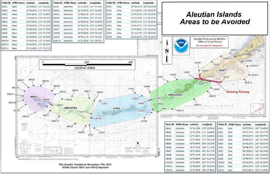
4 II. AREAS TO BE AVOIDED IN THE REGION OF THE ALEUTIAN ISLAND ARCHIPELAGO Reference charts: United States 16011, 2012 edition; United States 16012, 2005 edition. Note: These charts are based on North American 1983 Datum (NAD 83) which is equivalent to World Geodetic System 1984 Datum (WGS 84). Description of the areas to be avoided: In order to reduce the risk of a marine casualty and resulting pollution and damage to the environment "In the Region of the Aleutian Island Archipelago", all ships 400 gross tons and above solely in transit should avoid the areas to be avoided bounded by lines connecting the following geographical positions: 1. East ATBA An area to be avoided is established and bounded by a line connecting the following geographical positions: (1) 54 07'.94 N '.48 W (7) 56 19'.83 N '.29 W (2) 54 22'.14 N '.57 W (8) 56 04'.91 N '.04 W (3) 54 43'.51 N '.77 W (9) 55 40'.94 N '.43 W (4) 54 59'.45 N '.74 W (10) 55 22'.58 N '.19 W (5) 55 43'.20 N '.05 W (11) 54 41'.38 N '.66 W (6) 56 08'.30 N '.14 W (12) 54 21'.99 N '.54 W thence back to point (1). 2. Unalaska ATBA An area to be avoided is established and bounded by a line connecting the following geographical positions: (13) 51 41'.19 N '.93 W (19) 54 21'.96 N '.77 W (14) 51 53'.22 N '.60 W (20) 54 11'.15 N '.63 W (15) 52 41'.95 N '.08 W (21) 53 40'.84 N '.67 W (16) 53 17'.64 N '.31 W (22) 53 24'.39 N '.37 W (17) 54 09'.49 N '.53 W (23) 52 46'.62 N '.33 W (18) 54 17'.62 N '.32 W (24) 51 57'.40 N '.60 W thence back to point (13). 3. Atka ATBA An area to be avoided is established and bounded by a line connecting the following geographical positions: (25) 50 38'.55 N '.00 W (30) 52 41'.07 N 'W (26) 51 11'.83 N '.46 W (31) 51 37'.86 N 'W (27) 52 39'.35 N '.78 W (32) 51 15'.27 N 'W (28) 53 13'.18 N '.18 W (33) 50 21'.63 N 'W (29) 53 02'.71 N '.16 W (33) 50 21'.63 N 'W thence back to point (25). 4
5 4. Amchitka ATBA An area to be avoided is established and bounded by a line connecting the following geographical positions: (34) 51 51'.50 N '.54 E (39) 52 36'.31 N 'W (35) 52 15'.54 N '.24 E (40) 51 32'.27 N 'W (36) 52 46'.63 N '.15 E (41) 50 33'.65 N 'E (37) 52 57'.86 N '.91 E (42) 50 44'.11 N 'E (38) 52 48'.39 N '.00 W (43) 51 21'.00 N 'E thence back to point (34). 5. West ATBA An area to be avoided is established and bounded by a line connecting the following geographical positions: (44) 53 40'.90 N '.53 E (50) 52 08'.23 N '.75 E (45) 53 49'.20 N '.47 E (51) 51 40'.59 N '.27 E (46) 53 47'.85 N '.48 E (52) 52 20'.90 N '.34 E (47) 53 24'.41 N '.79 E (53) 52 40'.53 N '.34 E (48) 53 07'.49 N' '.74 E (54) 53 00'.92 N '.20 E (49) 52 19'.54 N '.62 E (55) 53 23'.69 N '.71 E thence back to point (44) 5

6 DESIGNATED PASSES IN THE ALEUTIAN ISLAND ARCHIPELIGO 6

7 ATBAS IN THE ALEUTIAN ISLAND ARCHIPELIGO COMMONLY USED GREAT CIRCLE ROUTES THROUGH THE ALEUTIAN ISLAND ARCHIPELIGO 7
8 8
9 II. MANDITORY ROUTE IN THE REGION OF THE BERING SEA As part of our APC you are required to utilize the following route when you navigate through the Bering Sea North of 60 degrees. A. Mandatory routing does not apply to vessels engaged in fishing. Deviations from this route must be submitted to 1-Call Alaska for approval via the USCG. Reference charts: United States 16066, 2015 edition; United States 16220, 2013 edition. Note: These charts are based on North American 1983 Datum (NAD 83) which is equivalent to World Geodetic System 1984 Datum (WGS 84). WAYPOINTS ARE AS FOLLOWS: ' N ' W ' N ' W ' N ' W ' N ' W ' N ' W ' N ' W ' N ' W ' N ' W ' N ' W ' N ' W 9

10 Mandatory Route Through the Bering Sea 10
11 III. AREAS TO BE AVOIDED IN THE REGION OF THE BERING SEA In addition to the mandatory routing, all 1-Call Alaska Vessels must comply with our Areas to Be Avoided (ATBA s) within the Bering Sea. These areas should not be used in normal operations as a potential place of refuge. Should the vessel need to utilize them for storm weather deviations, casualty, or another circumstance beyond the scope of normal operations, a deviation form must be approved by 1-Call Alaska. The ATBA s are established and bounded by the geographical points listed below. Reference charts: United States 16066, 2015 edition; United States 16220, 2013 edition. Note: These charts are based on North American 1983 Datum (NAD 83) which is equivalent to World Geodetic System 1984 Datum (WGS 84). 1. Bering Strait ATBA: An area to be avoided is established and bounded by a line connecting the following geographical positions: a N W b N W c N W d N W Thence to point a 2. King Island ATBA: An area to be avoided is established and bounded by a line connecting the following geographical positions: a N W b N W c N W d N W Thence to point a 3. St. Lawrence Island ATBA: An area to be avoided is established and bounded by a line connecting the following geographical positions: a N W b N W c N W d N W e N W f N W g N W h N W i N W Thence to point a 11
12 4. Nunivak Island ATBA: An area to be avoided is established and bounded by a line connecting the following geographical positions: a N W b N W c N W d N W e N W Thence to point a 12

13 ATBAS IN THE NORTHERN BERING SEA/STRAIT AREA 13
14 IV. Deviation Process The Deviation process is initiated when the captain determines the need to change course or route through WAK waters or to reduce speed to drift. The Captain is expected to inform 1-Call Alaska of the change via AS SOON AS POSSIBLE, so that the Coordination Center can process and seek approval for his new routing plan. This process applies to both innocent and non-innocent passage ships. There are two types of deviations that are issued by 1-Call Alaska, please see the lists below for an idea of what circumstances require specific deviation approval procedures. Deviations requiring USCG Approval (Call 1-Call Alaska for a deviation request ASAP) -Entering the ATBA for any reason -Utilizing the ATBA for storm weather avoidance -Changing course to come within 50 nm of shore (except when using the designated passes or mandatory Bering Sea Route) Deviations requiring 1-Call Alaska Acknowledgement ( 1-Call Alaska with new coordinates/information ASAP) -Deviating from planned course to any beyond 50nm from shore - Stopping or slowing speed in areas greater than 50nm to perform drills or routine maintenance. -Plotting a course in the Northern Bering Sea/Strait that does not utilize Mandatory Route. -Stopping/drifting the vessel anywhere within the US EEZ for mechanical casualty, -Any time the vessel broadcasts a Not Under Command status 1. Requesting a USCG Approved Deviation USCG Approved Permits require the vessel to fill out a storm weather avoidance form. This can be acquired by the captain by calling the Coordination Center or ing ops@1callalaska.com Once we provide the form to you, please fill it out and return it to us, we will submit it to Sector Anchorage on your behalf. If approved by Sector Anchorage, 1-Call Alaska will the Captain the approval and serve as the point of contact for both the Ship and USCG Sector Anchorage. If initial approval is not granted we will contact the ship with the USCG s requirements and help with the resubmission of another deviation request. 2. Status Updates During Deviation Once your vessel has begun the deviation, you are required to report status updates to 1-Call Alaska at the following frequency. 14
15 a. Casualties required to be reported under 33 CFR : updates should occur at least on the ½ hour and in no case shall they occur less than hourly. b. Weather related deviations: 12-hour status reporting c. Mechanical related deviations: 2-hour reporting d. All other Deviations: 6-hour reporting until vessel is greater than 50nm from shore e. Reporting should include the following information Ships condition Ships speed (if not applicable please provide ships drift speed) Wind direction Swell height Mechanical repair progress (if applicable) Estimate of time remaining in area 3. Requesting a 1-Call Alaska Approved Deviation 1-Call Alaska approved deviations are requested by sending the updated course to ops@1callalaska.com. Our watch standers will log your new course/delay/etc. and send a confirmation to the vessel, at which point the vessel is free to begin adjusting its course to the deviation route it had submitted. For routine mechanical related delays, the vessel shall report to the 1-Call Alaska Coordination Center at two-hour intervals and should include: Ships condition Ships speed (if not applicable please provide ships drift speed) Ships heading/course Wind direction Swell height Routine maintenance progress (if applicable) Estimate of time remaining not under command 15
16 V. Contact information 1-Call Alaska Coordination Center (24 hr number) (24 hr ) USCG Sector Anchorage (24 hr number) (24 hr ) 16
17 VI. Maritime Emergency Response Assets 1. Unalaska/Dutch Harbor Emergency Towing: 1-Call Alaska towing vessels along with towing vessels that are part of the 1-Call Rapid Response Network (R2N) are available to conduct emergency towing should the need arise. 1-Call Alaska holds USCG approved agreement with Dunlap, Foss, Harley Marine, AMAK, Survey Point and other towing companies. The 1-Call Alaska Coordination center actively tracks the location of towing vessels in the area. Marine Fire Fighting: The Dutch Harbor MFF Package has a 6,000 GPM fire pump, various monitors and nozzles, hose, and 1,200 gallons of 1 x 3 AR AFFF foam concentrate. Bunker gear and SCBA s for a 4-man team. Boom: The 1-Call Alaska boom inventory in Unalaska includes a total of 32,000+ feet of 18, 24, and 42 inch boom, to be used for protection and containment of oil. The boom is stored with anchoring and towing systems in 20 ft intermodal containers at the 1-Call Alaska facility in Dutch Harbor and ready for rapid deployment. Skimming Ability: Type Quantity EDRC (Derated) Elastec X bbl (Inland/Oceans) Elastec Ocean Skimmer bbl (Inland/Oceans) Aqua Guard Triton bbl ((Inland) Desmi Mini Max bbl (Inland) TOTAL bbl/day Temporary Storage Capacity: Size Gallons Description Fixed / Portable Notes 40,000 Yaveh Barge Fixed 8,000 Vertical Fixed 2X4,000 8,000 Skid Mounted Portable 2X4,000 43,000 FRAC Tank Portable 2x500bbl 10,000 Skid Mounted Portable 2X5,000 24,000 ISO Tanks Portable 22,000 Skid Mounted Portable 924,500 IBIS Barge Portable 1,079,500 gal 25,104 BBL 17
18 2. Nome Staged at the Port of Nome, the 1-Call Alaska MMPD Package is staged for rapid deployment to the Southern Chukchi Sea, Bering Strait and Northern Bering Sea Regions. Boom: 2,000 Feet of Optimax I - S/S top tension 7" Freeboard 12" draft OptiMax I - 19 Series" 4 Tow Bridles with Floats. Skimming Ability: Type Quantity EDRC (De-rated) TDS 118G Grooved drum Skimmer system ( Skimmer head, D10 Hyd Power Pack, E- 150 Transfer pump) TOTAL 5760 bbl/day Temporary Storage Capacity: Size Gallons Description Fixed / Portable Notes 4,000 USG Pillow tanks w/ Portable 4 x 1,000 gal units ground cover and carry bag 4,000 gal 95 bbl Miscellaneous Support Gear: Non-Tank Vessel Clean UP Kit, Includes PPE Decon, shoreline clean up, bird hazing etc as required by ADEC 3. Homer Staged at Moore and Moore, Homer Alaska the RMG WCD1 Package is ready for rapid deployment to The Cook Inlet and Northern Gulf of Alaska. Boom: 30,000 ft 19" Boom - Optimax I - S/S top tension 7" Freeboard 12" draft "OptiMax I - 19 Series, 2,000 ft 42" Boom - Supermax II S/S top tension 15" freeboard 27" draft "Supermax II Series" Skimming Ability: Type Quantity EDRC (Derated) TDS118G Grooved drum Skimmer system ( 2 11,520 bbl EDRC (2x5760) Skimmer head, D10 Hyd Power Pack, E-150 Transfer pump) Ocean Skater weir skimmer system 2 44,570 bbl EDRC (2x22285) (Skimmer head, D100 hyd power pack, Pump, Hoses, hose reel) TOTAL 56,090 bbl/day 18
19 Temporary Storage Capacity: Size Gallons Description Fixed / Portable Notes 35,000 USG Towable Portable 10 x 3,500 gal units bladder (XR-5 Fabric) 35,000 gal 833 bbl Miscellaneous Support Gear: Non-Tank Vessel Clean UP Kit, Includes PPE Decon, shoreline clean up, bird hazing etc as required by ADEC 4. Anchorage Staged at Resolve Aviation, 6321 S Airpark Place Anchorage Alaska is Resolve s rapidly deployable air response kit. The Kit can be taken anywhere in state to begin initial spill response capability. The Kit is designed for both Source Control and Oil Spill Response, depending on the assignment. Boom: 500 feet of 17.5 Inflatable boom (Airmax River Series) 8 freeboard 8 draft, ready for airborne deployment from the RESOLVE PILATUS Skimming Ability: Type Quantity EDRC (Derated) Mini Max Air Operated bbl (Inland/Oceans) Skimmer with transfer pump and accessories kit TOTAL 342 bbl/day Temporary Storage Capacity: Size Gallons Description Fixed / Portable Notes 2000 USG Pillow tanks w/ ground cover and carry bag Portable 2 X 1000 gal units Marine Firefighting Package: 4,500 gpm pump with monitor nozzles, fire hose, and associated equipment. Bunker gear and SCBA s for 6-man team 1,100 gal of 1 x 3 AFFF-ATC Concentrate. Source Control Kit: Source Control Kit w hydraulic submersible and diaphragm pumps Miscellaneous Support Gear: 6-man radio package, Miko Magnets MAM Light Model with Air Freight Box, hose, PPE adapters and tools for fly away, and a 4-stroke boom inflator. 19
AK-APC-NTV Operating Procedures for Cargo and Passenger Non Tank Vessels Transiting and Operating in Alaska Waters December 26, 2015
 AK-APC-NTV Operating Procedures for Cargo and Passenger Non Tank Vessels Transiting and Operating in Alaska Waters December 26, 2015 The Alternative Planning Criteria (APC) Operating Procedures were developed
WAK-APC-T Operating Procedures for Oil Tankers Transiting or Operating in Western Alaska Waters
 WAK-APC-T Operating Procedures for Oil Tankers Transiting or Operating in Western Alaska Waters RECORD OF CHANGE WAK-APC-T Operating Procedures for Oil Tankers Transiting or Operating In Western Alaska
APC Operating Procedures Oil Tankers
 APC Operating Procedures Oil Tankers August 2013 The APC Operating Procedures were developed to aid the Master and Operator of oil tankers in ensuring all aspects of the APC are complied with when transiting
LOCAL NOTICE TO MARINERS
 USCG Notice to Mariners 3/7/18 (View full Notice here) LNM 10/18 Coast Guard District 1: U.S. Department of Homeland Security United States Coast Guard LOCAL NOTICE TO MARINERS COASTAL WATERS FROM EASTPORT,
Response Boat & Barge
 Response Boat & Barge Oil Spill Equipment Floating Barriers Incinerators ELASTEC INLANDER BOAT & BARGE Work Horse of the Waterways With the speed of a thoroughbred and the strength of a draft horse, the
LOCAL NOTICE TO MARINERS
 USCG Notice to Mariners 3/26/15 (View full Notice here) LNM 12/15 Coast Guard District 1 : U.S. Department of Homeland Security United States Coast Guard LOCAL NOTICE TO MARINERS COASTAL WATERS FROM EASTPORT,
Harbor Safety Committee HEAVY WEATHER (WX)
") HEAVY WEATHER (WX) SOC Quick Reference Risk Petroleum transfers Mooring buoys- Operating Policies and Weather Criteria General mooring policies, breakaway prevention Derelict and unattended vessels (abandoned
HEAVY WEATHER (WX) SOC Quick Reference Risk Petroleum transfers Mooring buoys- Operating Policies and Weather Criteria General mooring policies, breakaway prevention Derelict and unattended vessels (abandoned
Delaware River Vessel Reporting System Mariners Advisory Committee For
 Delaware River Vessel Reporting System Mariners Advisory Committee For the Bay and River Delaware The Mariner's Advisory Committee is comprised of Master Mariners, River Pilots, and concerns itself with
References: Manual Chapt. 9 ISO 9001 par.7 ISO par. 4 ISM Code par. 7; 8
 SQEMS OPERATING PROCEDURE OP-SAF-03 1 of 5 References: Manual Chapt. 9 ISO 9001 par.7 ISO 14001 par. 4 ISM Code par. 7; 8 1. SCOPE This Procedure establishes criteria for the control and management of
OFFSHORE PATROL VESSEL OPERATIONS
 Florida Fish and Wildlife Conservation Commission Division of Law Enforcement OFFSHORE PTROL VESSEL OPERTIONS GENERL ORDER EFFECTIVE DTE RESCINDS/MENDS PPLICBILITY 30 May 7, 2018 July 21, 2008 ll Sworn
Marine Safety Information Bulletin COAST GUARD GUIDANCE FOR DEAD SHIP MOVEMENT IN SECTOR HONOLULU CAPTAIN OF THE PORT ZONE.
 Marine Safety Information Bulletin 16-002 U.S. DEPARTMENT OF HOMELAND SECURITY U. S. Coast Guard Sector Honolulu Sand Island Parkway Honolulu, Hawaii 96819 (808) 842-2600 COAST GUARD GUIDANCE FOR DEAD
LOWER MISSISSIPPI RIVER PRE-ENTRY INFORMATION
 LOWER MISSISSIPPI RIVER PRE-ENTRY INFORMATION Notice of Arrivals Prior to Arrival at any U.S. port, the vessel master should ensure a complete and accurate Notice of Arrival has been submitted to National
SAFETY MANAGEMENT MANUAL SOP-PRT-007N. Ballast Water Management Plan (Proteus)
") Page 1 of 5 1.0 Introduction 2.0 References 3.0 Procedures 3.1 Potable Water 3.2 Sea Water 3.3 Alternate Procedures Under Extraordinary Conditions 4.0 Responsibilities 5.0 Reports 6.0 Definitions Revision/
Page 1 of 5 1.0 Introduction 2.0 References 3.0 Procedures 3.1 Potable Water 3.2 Sea Water 3.3 Alternate Procedures Under Extraordinary Conditions 4.0 Responsibilities 5.0 Reports 6.0 Definitions Revision/
SAFETY MANAGEMENT MANUAL SOP-GYRE-007N. Ballast Water Management Plan (Gyre) SOP GYRE-007N
 SOP GYRE-007N") Page 1 of 5 SOP GYRE-007N 1.0 Introduction 2.0 References 3.0 Procedures 3.1 Potable Water 3.2 Sea Water 3.3 Alternate Procedures Under Extraordinary Conditions 4.0 Responsibilities 5.0 Reports 6.0 Definitions
Page 1 of 5 SOP GYRE-007N 1.0 Introduction 2.0 References 3.0 Procedures 3.1 Potable Water 3.2 Sea Water 3.3 Alternate Procedures Under Extraordinary Conditions 4.0 Responsibilities 5.0 Reports 6.0 Definitions
AMSA A Roadmap Forward & Relevant Alaska Activities. Captain Bob Pawlowski, NOAA (Ret), MNI Legislative Liaison to the Denali Commission
, MNI Legislative Liaison to the Denali Commission") AMSA A Roadmap Forward & Relevant Alaska Activities Captain Bob Pawlowski, NOAA (Ret), MNI Legislative Liaison to the Denali Commission Selected AMSA Key Findings UNCLOS: Fundamental framework IMO: Competent
AMSA A Roadmap Forward & Relevant Alaska Activities Captain Bob Pawlowski, NOAA (Ret), MNI Legislative Liaison to the Denali Commission Selected AMSA Key Findings UNCLOS: Fundamental framework IMO: Competent
GUIDELINES FOR NAVIGATION UNDER THE CONFEDERATION BRIDGE
 (12/2009) GUIDELINES FOR NAVIGATION UNDER THE CONFEDERATION BRIDGE REVISION 1 DECEMBER 2009 Responsible Authority The Regional Director Marine Safety Atlantic Region is responsible for this document, including
Southwest Florida Local Emergency Planning Committee (SWF LEPC) Hazardous Materials Response in Rural Areas Standard Operating Procedures (SOP)
 Hazardous Materials Response in Rural Areas Standard Operating Procedures (SOP)") Southwest Florida Local Emergency Planning Committee (SWF LEPC) 1.1 Assumptions Hazardous Materials Response in Rural Areas Standard Operating Procedures (SOP) a. This procedure is not all-inclusive but
Southwest Florida Local Emergency Planning Committee (SWF LEPC) 1.1 Assumptions Hazardous Materials Response in Rural Areas Standard Operating Procedures (SOP) a. This procedure is not all-inclusive but
ROUTEING MEASURES OTHER THAN TRAFFIC SEPARATION SCHEMES
 E 4 ALBERT EMBANKMENT LONDON SE1 7SR Telephone: +44 (0)20 7735 7611 Fax: +44 (0)20 7587 3210 SN.1/Circ.317 4 December 2012 ROUTEING MEASURES OTHER THAN TRAFFIC SEPARATION SCHEMES 1 The Maritime Safety
properly applied assessment in the use.1 landmarks.1 approved in-service of ECDIS is not experience The primary method of fixing required for those
 STCW Code Table A-II/3 Specification of minimum standard of for officers in charge of a navigational watch and for masters on ships of less than 500 gross tonnage engaged on near-coastal voyages Ref: https://www.edumaritime.net/stcw-code
Vessel Traffic in the Salish Sea Mitigating Risk... Captain Joe Raymond Coast Sector Puget Sound
 Vessel Traffic in the Salish Sea Mitigating Risk.... Captain Joe Raymond Coast Sector Puget Sound Overview Prevention Waterways Management Oil Spill Data Mitigating Risks Sector Puget Sound AOR Blan k
ANNEX 2. RESOLUTION MSC.256(84) (adopted on 16 May 2008)
 (adopted on 16 May 2008)") RESOLUTION MSC.256(84) (adopted on 16 May 2008) ADOPTION OF AMENDMENTS TO THE INTERNATIONAL CONVENTION FOR THE SAFETY OF LIFE AT SEA, 1974, AS AMENDED THE MARITIME SAFETY COMMITTEE, RECALLING Article 28(b)
RESOLUTION MSC.256(84) (adopted on 16 May 2008) ADOPTION OF AMENDMENTS TO THE INTERNATIONAL CONVENTION FOR THE SAFETY OF LIFE AT SEA, 1974, AS AMENDED THE MARITIME SAFETY COMMITTEE, RECALLING Article 28(b)
Report on Vessel Casualty of Accident (Form Casualty) Instructions:
 Instructions:") Report on Vessel Casualty of Accident (Form Casualty) Tuvalu Ship Registry 10 Anson Road #25-16 International Plaza Singapore 079903 Tel: (65) 6224 2345 Fax: (65) 6227 2345 Email: info@tvship.com Website:
Report on Vessel Casualty of Accident (Form Casualty) Tuvalu Ship Registry 10 Anson Road #25-16 International Plaza Singapore 079903 Tel: (65) 6224 2345 Fax: (65) 6227 2345 Email: info@tvship.com Website:
SEAPRO VESSEL OPERATIONS AND NAVIGATION GUIDE
 SEAPRO VESSEL OPERATIONS AND NAVIGATION GUIDE 1 V E S S E L O P E R A T I O N S G U I D E Introduction Operator Responsibility Activation Communications Manning Equipment Rest Periods Weather Vessel Designations
Enhanced Discussion of Requirements for Commercial Fishing Vessels
 Update on U.S. Commercial Fishing Industry Vessel Requirements Based On Section 604 of the Coast Guard Authorization Act of 2010 (Public Law 111-281) And Section 305 of the Coast Guard and Maritime Transportation
Alaska Department of Environmental Conservation Non Crude Marine Vessels Group Mission
 State of Alaska Oil Discharge Prevention and Contingency Plan Jurisdiction and Requirements Alaska Department of Environmental Conservation Non Crude Marine Vessels Group Mission Review ODPCP s in accordance
COAST GUARD ADVISORY NOTICE (CGAN ) To: Distribution Date: September 1, 2017
 To: Distribution Date: September 1, 2017") Commander United States Coast Guard Sector New York 212 Coast Guard Drive Staten Island, NY 10305 Staff Symbol: (spw) Phone: (718) 354-2353 Fax: (718) 354-4190 COAST GUARD ADVISORY NOTICE (CGAN 2017-016)
Commander United States Coast Guard Sector New York 212 Coast Guard Drive Staten Island, NY 10305 Staff Symbol: (spw) Phone: (718) 354-2353 Fax: (718) 354-4190 COAST GUARD ADVISORY NOTICE (CGAN 2017-016)
Oahu Equipment List KAHE POWER PLANT BOOM TRAILER SPECTRUM TRAILER W/ 1000' ACME BOOM 1000 FEET
 Oahu Equipment List Location Equipment Type Description Quantity Units BARBER'S PT. API SEPARATOR VERSITEK API SEPARATOR 1 EACH BARBER'S PT. BOOM BOAT 21 FT. BOSTON WHALER WITH TWIN O/B'S 1 EACH BARBER'S
WCMRC Technical Manual. Waste Management Tactics
 WCMRC Technical Manual Waste Management Tactics this page left intentionally blank 74 P a g e WASTE MANAGEMENT TACTICS PURPOSE OF THE WASTE MANAGEMENT TACTICS This section covers waste management issues
ASSOCIATED BRITISH PORTS - LOWESTOFT
 ASSOCIATED BRITISH PORTS - LOWESTOFT PILOTAGE DIRECTION (With Amendments To 01/02/2012) 1. AUTHORISATION Pilotage Act 1987. Associated British Ports Lowestoft (Pilotage) Harbour Revision Order 1988. 2.
ST. VINCENT AND THE GRENADINES
 ST. VINCENT AND THE GRENADINES MARITIME ADMINISTRATION CIRCULAR N SOL 036 Amendment to SOLAS 1974 as amended, Resolution MSC.256 (84) TO: SHIPOWNERS & SHIPS OPERATORS & MANAGERS, MASTERS SURVEYORS TO FLAG
Incident Management Guidelines for Initial Actions and Communications
 Lower Columbia Region Harbor Safety Committee Incident Management Guidelines for Initial Actions and Communications Page 1 of 16 Table of Contents A. INCIDENT MANAGEMENT GUIDELINES... 3 1. PURPOSE... 3
OPERATIONS SEAFARER CERTIFICATION GUIDANCE NOTE SA MARITIME QUALIFICATIONS CODE. Deck: Chart Work
 Page 1 of 6 Compiled by Approved by Chief Examiner Syllabus Committee: 26 February 2013 OPERATIONS SEAFARER CERTIFICATION GUIDANCE NOTE SA MARITIME QUALIFICATIONS CODE Deck: Chart Work Page 2 of 6 COLUMN
Severe Weather Planning Information. Maritime Stakeholders
 Severe Weather Planning Information for the Maritime Stakeholders Port Arthur Captain of the Port Zone Sabine-Neches Waterway, Calcasieu Waterway and Gulf Intracoastal Waterway Revised: May 2018 INTRODUCTION
New Requirements for Commercial Fishing Industry Vessels Section 604 Coast Guard Authorization Act of 2010 (Public Law )
") New Requirements for Commercial Fishing Industry Vessels Section 604 Coast Guard Authorization Act of 2010 (Public Law 111-281) On October 15, 2010, the President signed the law that included provisions
New Requirements for Commercial Fishing Industry Vessels Section 604 Coast Guard Authorization Act of 2010 (Public Law 111-281) On October 15, 2010, the President signed the law that included provisions
TOWING OFFICER ASSESSMENT RECORD
 TOWING OFFICER ASSESSMENT RECORD NEAR COASTAL / OCEANS SIGNATED EXAMINER INFORMATION All Designated Examiners (s) signing off successful completion of practical assessments should provide the information
ADMINISTRATIVE INSTRUCTION No. STCW-14 QUALIFICATION / CERTIFICATION REQUIRED FOR OPERATION OF A DOMESTIC VESSESL
 ADMINISTRATIVE INSTRUCTION No. STCW-14 QUALIFICATION / CERTIFICATION REQUIRED FOR OPERATION OF A DOMESTIC VESSESL (Issued under section 3(5) of the Gibraltar Merchant Shipping (Safety etc.) Ordinance 1993
PILOTAGE DIRECTIONS REVIEWED DECEMBER 2016
 PILOTAGE DIRECTIONS REVIEWED DECEMBER 2016 REVISION LIST Revision No. Date Details Approved by: Original All sections 12 Dec 2013 First edition of C W Brand v1.0 Pilotage Directions Revision 2 all sections
U.S. Coast Guard Sector Mobile
 U.S. Coast Guard Sector Mobile Maritime Severe Weather Contingency Port Plan A Guide to Port Planning and Preparation X-2-1 TABLE OF CONTENTS INTRODUCTION Background 1 Authority 1 Applicability and Purpose
Towed Barge Standard of Care
 Lower Columbia Region Harbor Safety Committee Towed Barge Standard of Care Page 1 of 6 A. 1. Purpose The Columbia River is intended to eliminate conflicts between towing vessels conducting astern towing
ROUTEING MEASURES AND MANDATORY SHIP REPORTING SYSTEMS. Establishment of three new areas to be avoided in the Bering Sea
 E SUB-COMMITTEE ON NAVIGATION, COMMUNICATIONS AND SEARCH AND RESCUE 5th session Agenda item 3 NCSR 5/3/8 17 November 2017 Original: ENGLISH ROUTEING MEASURES AND MANDATORY SHIP REPORTING SYSTEMS Establishment
TICES TO MARINERS 1 TO 46 ANNUAL EDITION 2018 SECTION A AIDS TO NAVIGATION AND MARINE SAFETY
 A5 NAVIGATION SAFETY 10 Routeing of Ships 1 GENERAL 1.1 Rule 10 of the Collision Regulations applies to all ships navigating in or near a routeing system. 1.2 The information on ships' routeing in this
SECTION II NM 26/10 NAVIGATION PUBLICATIONS ALMANACS CORRECTIONS
 NAVIGATION PUBLICATIONS ALMANACS CORRECTIONS NAUTICAL ALMANAC Ed 2011 NEW EDITION (NGA) 26/10 SAILING DIRECTIONS CORRECTIONS PUB 140 8 Ed 2010 NEW EDITION (NGA) 26/10 COAST PILOT CORRECTIONS COAST PILOT
MARINE CIRCULAR MC-25/2012/1
 Singapore Operations Office: 10 Anson Road #25-16, International Plaza, Singapore 079903 Tel: (65) 6224 2345 Fax: (65) 6227 2345 Email: info@tvship.com Website: www.tvship.com 4/2013 MARINE CIRCULAR MC-25/2012/1
MANAGEMENT SYSTEM MANUAL
 1. Purpose The purpose of this procedure is to establish routine check-off lists to be used in preparation for arrival and departure aboard the R/V Oceanus. 2. Responsibility The Master is responsible
The Coast Guard has 145 Years of Arctic Service UNCLASSIFIED
 The Coast Guard has 145 Years of Arctic Service 1 Operational Challenges Maritime Boundary Line Nome Barrow Great Distances Kodiak-Barrow = 825 NM Dutch Harbor - Barrow = 1167 NM Barrow-North Pole= 1,140
Forth Ports Limited. Port of Dundee. Rig Move Guidelines
 Forth Ports Limited Port of Dundee Contents 1 Introduction... 4 2 Pre-Arrival... 4 2.1 Planning Meetings... 4 2.2 Priority of Movements... 4 2.3 Confirmation/Cancellations... 5 2.4 Weather Parameters...
This training is intended to be educational and should not be construed as legal guidance. It is provided as a courtesy to our customers and others
 June 2012 This training is intended to be educational and should not be construed as legal guidance. It is provided as a courtesy to our customers and others who may benefit from the information contained
SAILING INSTRUCTIONS. Port of Los Angeles Harbor Cup Cal Maritime Invitational Intercollegiate Regatta March 9 th -11 th, RULES
 SAILING INSTRUCTIONS Port of Los Angeles Harbor Cup Cal Maritime Invitational Intercollegiate Regatta March 9 th -11 th, 2018 1 RULES 1.1 The regatta will be governed by the ICSA Procedural Rules (PR),
USCG COMMERCIAL FISHING VESSEL SAFETY EXAMINATION
 USCG COMMERCIAL FISHING VESSEL SAFETY EXAMINATION Call Sign: Other Identifier: Hull Color: Trim Color: Superstructure Color: Vessel Length: Gross Tonnage: Maximum POB: Hull Type: Wood Aluminum Fiberglass
M/V SELENDANG AYU. Unalaska Island, Alaska
 M/V SELENDANG AYU Unalaska Island, Alaska December 2004 1 Characteristic Aleutians Response Foreign flag vessel on innocent passage Lack of spill response vessels Economically important fisheries Subsistence
National Maritime Center
 National Maritime Center Providing Credentials to Mariners Master TV to Master Less than 500 Gross Registered Tons Oceans or Near Coastal (Sample Examination) Page 1 of 6 Master TV to Master Less than
Chief-Planning & Readiness USCG Sector Houston-Galveston
 Boom Efficacy During the DEEPWATER HORIZON Response LCDR Joseph J. Leonard, Jr. Chief-Planning & Readiness USCG Sector Houston-Galveston June 2011 Boom Selection Responder Skill Sets Boom Utilization Site
INTERNATIONAL NAVIGATION LIMITS (INL)
") INTERNATIONAL NAVIGATION LIMITS (INL) (sometimes referred to as International Navigation Conditions) The International Navigating Limits (INL), formerly Institute Warranty Limits (IWL), were revised and
INTERNATIONAL NAVIGATION LIMITS (INL) (sometimes referred to as International Navigation Conditions) The International Navigating Limits (INL), formerly Institute Warranty Limits (IWL), were revised and
33 CFR Ch. I ( Edition)
") 151.1512 (b) No master of a vessel subject to this subpart shall separately discharge sediment from tanks or holds containing ballast water unless it is disposed of ashore in accordance with local requirements.
151.1512 (b) No master of a vessel subject to this subpart shall separately discharge sediment from tanks or holds containing ballast water unless it is disposed of ashore in accordance with local requirements.
DET NORSKE VERITAS & ERM - WEST, INC.
 DET NORSKE VERITAS & ERM - WEST, INC. Aleutian Islands Risk Assessment Phase A-Preliminary Risk Assessment Task 2A: Marine Spill Frequency and Size Report Prepared For: National Fish and Wildlife Foundation
RESOLUTION MSC.161(78) (adopted on 17 May 2004) AMENDMENTS TO THE EXISTING MANDATORY SHIP REPORTING SYSTEM "THE TORRES STRAIT AND INNER ROUTE OF THE
 (adopted on 17 May 2004) AMENDMENTS TO THE EXISTING MANDATORY SHIP REPORTING SYSTEM THE TORRES STRAIT AND INNER ROUTE OF THE") MSC 78/26/Add.2 RESOLUTION MSC.161(78) REPORTING SYSTEM THE TORRES STRAIT AND INNER ROUTE OF THE GREAT BARRIER REEF THE MARITIME SAFETY COMMITTEE, RECALLING Article 28(b) of the Convention on the International
MSC 78/26/Add.2 RESOLUTION MSC.161(78) REPORTING SYSTEM THE TORRES STRAIT AND INNER ROUTE OF THE GREAT BARRIER REEF THE MARITIME SAFETY COMMITTEE, RECALLING Article 28(b) of the Convention on the International
Enclosure (5) to NVIC 03-16
 to NVIC 03-16") TOWING OFFICER ASSESSMENT RECORD LIMITED LOCAL AREA LOCAL LIMITED AREA (LLA) TOAR INSTRUCTIONS FOR USE The following Towing Officer Assessment Record (TOAR) is intended as a model for endorsements as Limited
TOWING OFFICER ASSESSMENT RECORD LIMITED LOCAL AREA LOCAL LIMITED AREA (LLA) TOAR INSTRUCTIONS FOR USE The following Towing Officer Assessment Record (TOAR) is intended as a model for endorsements as Limited
Section Decanting Response Tool
 Section 9411 Decanting Response Tool T able of Contents Section Page 9411 Decanting Response Tool... 9411-1 9411.1 Introduction... 9411-1 9411.2 Decanting Policy... 9411-1 9411.2.1 Criteria... 9411-1 9411.2.2
Towing Officers' Assessment Record: Near Coastal/Oceans
 Towing Officers' Assessment Record: Near Coastal/Oceans NAME: LICENSE NO.: Task No. Considered Proficient Common Element Task or Duty DE's Initials Date A. Vessel Familiarization A.1. X Locate and demonstrate
OIL IN NAVIGABLE WATERS REGULATIONS [L.N. 101 of 1968.] under sections 5 and 7. [22nd April, 1968] [Comrnencernent.]
![OIL IN NAVIGABLE WATERS REGULATIONS [L.N. 101 of 1968.] under sections 5 and 7. [22nd April, 1968] [Comrnencernent.]](/thumbs/80/81393535.jpg "OIL IN NAVIGABLE WATERS REGULATIONS [L.N. 101 of 1968.] under sections 5 and 7. [22nd April, 1968] [Comrnencernent.]") OIL IN NAVIGABLE WATERS REGULATIONS [L.N. 101 of 1968.] under sections 5 and 7 [Comrnencernent.] [22nd April, 1968] 1. Short title and interpretation (1) These Regulations may be cited as the Oil in Navigable
OIL IN NAVIGABLE WATERS REGULATIONS [L.N. 101 of 1968.] under sections 5 and 7 [Comrnencernent.] [22nd April, 1968] 1. Short title and interpretation (1) These Regulations may be cited as the Oil in Navigable
PASSENGER SHIP SAFETY. Review of Operational Safety Measures to Enhance the Safety of Passenger Ships. Submitted by ICS SUMMARY
 MARITIME SAFETY COMMITTEE 92 nd session Agenda item 6 MSC 92/6/XX 2013 Original: ENGLISH PASSENGER SHIP SAFETY Review of Operational Safety Measures to Enhance the Safety of Passenger Ships Submitted by
Western Canadian Spill Services Ltd. Field Testing Exercise Report
 Western Canadian Spill Services Ltd. Field Testing Exercise Report Wednesday, July 15, 2009 Clearwater River, Rocky Mountain House, AB Background Western Canadian Spill Services Ltd. (WCSS) held a field
WORK-REST REQUIREMENTS FOR PILOTS
 AN ORDER OF THE BOARD OF PILOT COMMISSIONERS FOR THE PORT OF CORPUS CHRISTI AUTHORITY REGARDING WORK-REST REQUIREMENTS FOR PILOTS AND COMBINED BEAM RESTRICTION Whereas, the current Rules and Regulations
Ballast Water Management Reporting form Instructions
 Ballast Water Management Reporting form Instructions NOTE: Adobe Acrobat or Adobe Reader, version 9 or later, is required to use the PDF BWMR form. Adobe Reader can be downloaded for free here. VESSEL
CAPTAIN OF THE PORT, WESTERN ALASKA NAVIGATION SAFETY ADVISORY OPERATING GUIDELINES FOR ICE CONDITIONS IN COOK INLET
 Commander United States Coast Guard Sector Anchorage PO Box 5800 JBER, AK 99505 Staff Symbol: s Phone: 907-428-4144 Fax: 907-428-4138 16710 November 13, 2018 CAPTAIN OF THE PORT, WESTERN ALASKA NAVIGATION
International regulations and guidelines for maritime spatial planning related to safe distances to multiple offshore structures (e.g.
 International regulations and guidelines for maritime spatial planning related to safe distances to multiple offshore structures (e.g. wind farms) Introduction This is a summary of the most important international
ANCHORING. Small Craft Advisories (sustained winds 21 to 33 knots
 SOC Quick Reference ANCHORING Risk General Information All Puget Sound regions other than Smith Cove East and West in Elliott Bay and Commencement Bay All Weather Visibility Gale Warnings (sustained winds
ICE and WATER RESCUE
 Page 1 of 8 Last Revised 12/12 40.01 Scope: The Town of Menasha Fire Department is certified to the technician level according to NFPA 1670. Due to a lack of equipment and resources, emergency responses
MARINER S GUIDE TO THE FORTH
 MARINER S GUIDE TO THE FORTH INTRODUCTION 1. The Statutory Harbour Authority s area of jurisdiction on the River and Firth of Forth ( The Forth ) extends from approximately one mile west of the Isle of
National Maritime Center
 National Maritime Center Providing Credentials to Mariners Q301 Rules of the Road-Inland (Sample Examination) Page 1 of 19 Choose the best answer to the following Multiple Choice Questions. NO reference
29 cfr. 33 cfr. 46 US Code (Annotated) 46 cfr CHAPTER II CHAPTER I
 46 cfr CHAPTER II CHAPTER I") 29 cfr Captain Joe's DECK LICENSE PROGRAM G Documentation and Measurement of Vessels H Passenger Vessels 1902 Develop And Enforce Of State Standards I Cargo and Misc. Vessels 1903 Inspections, Citations
29 cfr Captain Joe's DECK LICENSE PROGRAM G Documentation and Measurement of Vessels H Passenger Vessels 1902 Develop And Enforce Of State Standards I Cargo and Misc. Vessels 1903 Inspections, Citations
Standard Operating Procedure
 Standard Operating Procedure BOOMS Offshore RO-BOOM / Lamor HD boom Equipment description SOP intended for the use and deployment of Lamor HD 1300 and Desmi Ro-clean 1500 offshore boom. The boom reel holds
Alaska Department of Environmental Conservation (ADEC) SOSC Updates and Planning Initiatives
 SOSC Updates and Planning Initiatives") Alaska Department of Environmental Conservation (ADEC) SOSC Updates and Planning Initiatives Gary Folley, Manager Prevention, Preparedness and Response Program January 26, 2016 SPAR is made up of 3 Programs:
Alaska Department of Environmental Conservation (ADEC) SOSC Updates and Planning Initiatives Gary Folley, Manager Prevention, Preparedness and Response Program January 26, 2016 SPAR is made up of 3 Programs:
GENERAL LIMITATIONS AND RESTRICTIONS. LNGC Temporary Exemption (Effective August 21, 2018)
") RULES AND REGULATIONS GOVERNING PILOTS AND PILOTAGE ON THE CORPUS CHRISTI SHIP CHANNEL EFFECTIVE AUGUST 1, 2013 AMENDED EFFECTIVE MAY 13, 2014 AMENDED EFFECTIVE OCTOBER 1, 2014 AMENDED EFFECTIVE JANUARY
RULES AND REGULATIONS GOVERNING PILOTS AND PILOTAGE ON THE CORPUS CHRISTI SHIP CHANNEL EFFECTIVE AUGUST 1, 2013 AMENDED EFFECTIVE MAY 13, 2014 AMENDED EFFECTIVE OCTOBER 1, 2014 AMENDED EFFECTIVE JANUARY
World Shipping Council. Bureau of Ocean Energy Management U.S. Department of the Interior
 Comments of the World Shipping Council Submitted to the Bureau of Ocean Energy Management U.S. Department of the Interior In the matters of Commercial Leasing for Wind Power Development on the Outer Continental
iii) Satisfactory completion of approved training in the following:
 Satisfactory completion of approved training in the following:") Enclosure (1) to NVIC 13-14 DISCUSSION OF QUALIFICATION REQUIREMENTS FOR MASTER AND OFFICER IN CHARGE OF A NAVIGATIONAL WATCH ON VESSELS OF LESS THAN 500 GT LIMITED TO NEAR-COASTAL WATERS 1. GENERAL. This
Enclosure (1) to NVIC 13-14 DISCUSSION OF QUALIFICATION REQUIREMENTS FOR MASTER AND OFFICER IN CHARGE OF A NAVIGATIONAL WATCH ON VESSELS OF LESS THAN 500 GT LIMITED TO NEAR-COASTAL WATERS 1. GENERAL. This
HOUSTON SEA CHEST CLOGGING SURVEY
 HOUSTON SEA CHEST CLOGGING SURVEY *** YOUR HELP IS VOLUNTARY AND ANONYMOUS*** ***PLEASE DO NOT INCLUDE VESSEL NAME OR NUMBER *** IT IS 2015 MENHADEN SEASON IN THE HOUSTON SHIP CHANNEL To Vessel Master/Chief
SCENARIO 18 Leak on Intermodal Pressure Tank Container
 INCIDENT OVERVIEW Your fire department responds to a marine terminal for a report of a gas leak involving an intermodal tank in a container yard. Upon arrival at the marine terminal, the Port Authority
Code of Federal Regulations
 Page 1 of 6 Code of Federal Regulations Title 33 - Navigation and Navigable Waters Volume: 2 Date: 2010-07-01 Original Date: 2010-07-01 Title: Section 165.1325 - Regulated Navigation Areas; Bars Along
INTERNATIONAL CONVENTION FOR THE CONTROL AND MANAGEMENT OF SHIPS' BALLAST WATER AND SEDIMENTS, 2004
 E INTERNATIONAL CONVENTION FOR THE CONTROL AND MANAGEMENT OF SHIPS' BALLAST WATER AND SEDIMENTS, 2004 BWM.2/Circ.35 15 August 2011 Communication received from the Regional Marine Pollution Emergency Response
Rules Practice Exam 12
 1 INLAND ONLY You are on vessel "A", and vessel "B" desires to overtake you on your starboard side as shown. After the vessels have exchanged one blast signals, you should. Diagram 31 A. alter course to
Safety Zones and Special Local Regulations; Recurring. Marine Events in Captain of the Port Long Island Sound Zone
 This document is scheduled to be published in the Federal Register on 05/19/2015 and available online at http://federalregister.gov/a/2015-12103, and on FDsys.gov 9110-04-P DEPARTMENT OF HOMELAND SECURITY
MARINE NOTICE MARINE NOTICE. Marine Notice 7/2012. Guidance on ECDIS for ships calling at Australian ports 7/2012
 MARINE NOTICE MARINE 7/2012 NOTICE Marine Notice 7/2012 Guidance on ECDIS for ships calling at Australian ports This notice aims to clarify some of the emerging issues relating to the carriage requirements
RESOLUTION MSC.256(84) (adopted on 16 May 2008) ADOPTION OF AMENDMENTS TO THE INTERNATIONAL CONVENTION FOR THE SAFETY OF LIFE AT SEA, 1974, AS
 (adopted on 16 May 2008) ADOPTION OF AMENDMENTS TO THE INTERNATIONAL CONVENTION FOR THE SAFETY OF LIFE AT SEA, 1974, AS") RESOLUTION MSC.256(84) ADOPTION OF AMENDMENTS TO THE INTERNATIONAL CONVENTION FOR THE SAFETY OF LIFE AT SEA, 1974, AS AMENDED THE MARITIME SAFETY COMMITTEE, RECALLING Article 28(b) of the Convention on
RESOLUTION MSC.256(84) ADOPTION OF AMENDMENTS TO THE INTERNATIONAL CONVENTION FOR THE SAFETY OF LIFE AT SEA, 1974, AS AMENDED THE MARITIME SAFETY COMMITTEE, RECALLING Article 28(b) of the Convention on
1972 Collision Regulations definition of a vessel. Note: Vessel length is measured from end to end over the deck, excluding sheer.
 User Definitions VMRS (Vessel Movement Reporting System) Users: Every power-driven vessel of 40 meters (approximately 131 feet) or more in length, while navigating; Every commercial vessel engaged in towing
COOPERATIVE VESSEL TRAFFIC SERVICE (CVTS) TAMPA BAY, FLORIDA
 TAMPA BAY, FLORIDA") COOPERATIVE VESSEL TRAFFIC SERVICE (CVTS) TAMPA BAY, FLORIDA USERS MANUAL Oct 2010 1 st Edition Serving the Port of Tampa, Port Manatee, Port of Saint Petersburg, and the Waterways of Tampa Bay 1 Table
COOPERATIVE VESSEL TRAFFIC SERVICE (CVTS) TAMPA BAY, FLORIDA USERS MANUAL Oct 2010 1 st Edition Serving the Port of Tampa, Port Manatee, Port of Saint Petersburg, and the Waterways of Tampa Bay 1 Table
OFFSHORE SUPPORT VESSELS 2015
 Part 1: Conditions of Classification (Supplement to the ABS Rules for Conditions of Classification) RULES FOR BUILDING AND CLASSING OFFSHORE SUPPORT VESSELS 2015 PART 1 CONDITIONS OF CLASSIFICATION (Supplement
IBF LIST of warlike and high risk designations, with main applicable benefits (as of 16 th December 2015):
:") IBF LIST of warlike and high risk designations, with main applicable benefits (as of 16 th December 2015): 1) IBF Warlike Operations Area 12 n.m. off Somali North Coast* 1a) IBF Warlike Operations Area
IBF LIST of warlike and high risk designations, with main applicable benefits (as of 16 th December 2015): 1) IBF Warlike Operations Area 12 n.m. off Somali North Coast* 1a) IBF Warlike Operations Area
The role of UKCM now and the future
 The role of UKCM now and the future NAV18 Torres Strait use case omcinternational.com Who is OMC International? Inventor (1993) and sole supplier of DUKC (>160,000 deep draft transits without incident)
Commonwealth of Dominica. Office of the Maritime Administrator
 Commonwealth of Dominica Office of the Maritime Administrator TO: ALL SHIPOWNERS, OPERATORS, MASTERS, AND SEAFARERS OF MERCHANT SHIPS, AND RECOGNIZED ORGANIZATIONS SUBJECT: REFERENCE: EMERGENCY TRAINING
Commandant United States Coast Guard NAVIGATION AND VESSEL INSPECTION CIRCULAR NO. 2-97, CHANGE 1
 Commandant United States Coast Guard 200 Second Street, S.W. Washington, DC 20593-000 Staff Symbol: G-MOC Phone: 202-267-464 A DISTRIBUTION SDL No. 34 a b c d e f g h I j k l m n o p q r s t u v w x y
Attachment 1 T&T Salvage, LLC Standard Tariff (Revision Date: 4 October 2013)
") PERSONNEL & ADMINISTRATION Rate SALVAGE TEAM: Salvage Master 2,100.00 1,785.00 Salvage Engineer / Naval Architect 2,100.00 1,785.00 Assistant Salvage Master 1,800.00 1,530.00 Salvage Dive Supervisor 1,800.00
PERSONNEL & ADMINISTRATION Rate SALVAGE TEAM: Salvage Master 2,100.00 1,785.00 Salvage Engineer / Naval Architect 2,100.00 1,785.00 Assistant Salvage Master 1,800.00 1,530.00 Salvage Dive Supervisor 1,800.00
NavRule Practice Exam, 70 Series Practice April 18, Labeled C have been copied to collection
 1C. INTERNATIONAL & INLAND There are two classes of vessel which, to the extent necessary to carry out their work, do not have to comply with the rule regarding traffic separation schemes. One of these
LAHAINA YACHT CLUB BOAT USE POLICY & REQUIREMENTS
 LAHAINA YACHT CLUB BOAT USE POLICY & REQUIREMENTS Adopted by the Board of Governors 3/15/17 I. INTRODUCTION The boats owned by the Lahaina Yacht Club (LYC) are used for events sponsored by the Club, such
SAILING INSTRUCTIONS
 Final June 11, 2012 SAILING INSTRUCTIONS 1. RULES 1.1 The race shall be governed by the rules as defined in the ISAF Racing Rules of Sailing. No national prescriptions shall apply. 1.2 The notice of race
FLAG OFFICERS Commodore Bob Lisiecki Vice Commodore John J. Frank Rear Commodore Charles Allen. DRYA PRINCIPAL RACE OFFICIAL Com Ed Theisen
 Great Lakes Yacht Club 2012 Fall Series Sailing Instructions INCLUDING THE 1 ST ANNUAL COM. ED THEISEN TROPHY RACE Sundays September 30 t h, October 7th, 14th, 21st, & Saturday, October 27 th FLAG OFFICERS
Summary Report. Grounding Twofold Bay. 20 July 2006
 Summary Report Grounding Twofold Bay 20 July 2006 NARRATIVE On the evening of 19 July 2006, the Skipper of Twofold Bay brought the vessel into Whangawehi Roads on the north coast of the Mahia Peninsula
2014 DRYA SAILING INSTRUCTIONS FOR A AND C COURSES
 2014 DRYA SAILING INSTRUCTIONS FOR A AND C COURSES These Detroit Regional Yacht-Racing Association ( DRYA ) sailing instructions (including the course-specific sailing instructions on pages 4-8) apply
Rules Practice Exam 5
 1 BOTH INTERNATIONAL & INLAND Vessel "A" (towing) and vessel "B" are meeting as shown. In this situation, which statement is TRUE? Diagram 12 A. Both vessels should alter course to starboard and pass port
SOUTHEAST ALASKA VOLUNTARY WATERWAY GUIDE
 SOUTHEAST ALASKA VOLUNTARY WATERWAY GUIDE Revisions Established: June 8, 1996 Revised: April 29, 1997 Revised: January 29, 1998 Revised: January 27, 1999 Revised: March 1, 2000 Revised: April, 14, 2001