Geomorphic Stream Classification A Classification of Natural Rivers, Rosgen, D.L.
|
|
|
- Noah Lee
- 6 years ago
- Views:
Transcription

1 Geomorphic Stream Classification A Classification of Natural Rivers, Rosgen, D.L.

2 Why is Stream Classification Physical stream channel evolution Essential? Similar stream types manifest similar patterns Natural channel design Planning and management Riverine habitats, plants and animals are constrained by natural channel physics Napeequa River


3 A stream is a portion of a fluvial system Stream Corridor Restoration: Principles, Processes, and Practices, 1998 We need a greater resolution on the landscape based on morphometry. It must be reproducible and measurable. We can communicate about a relatively complex description in relatively simple terms.
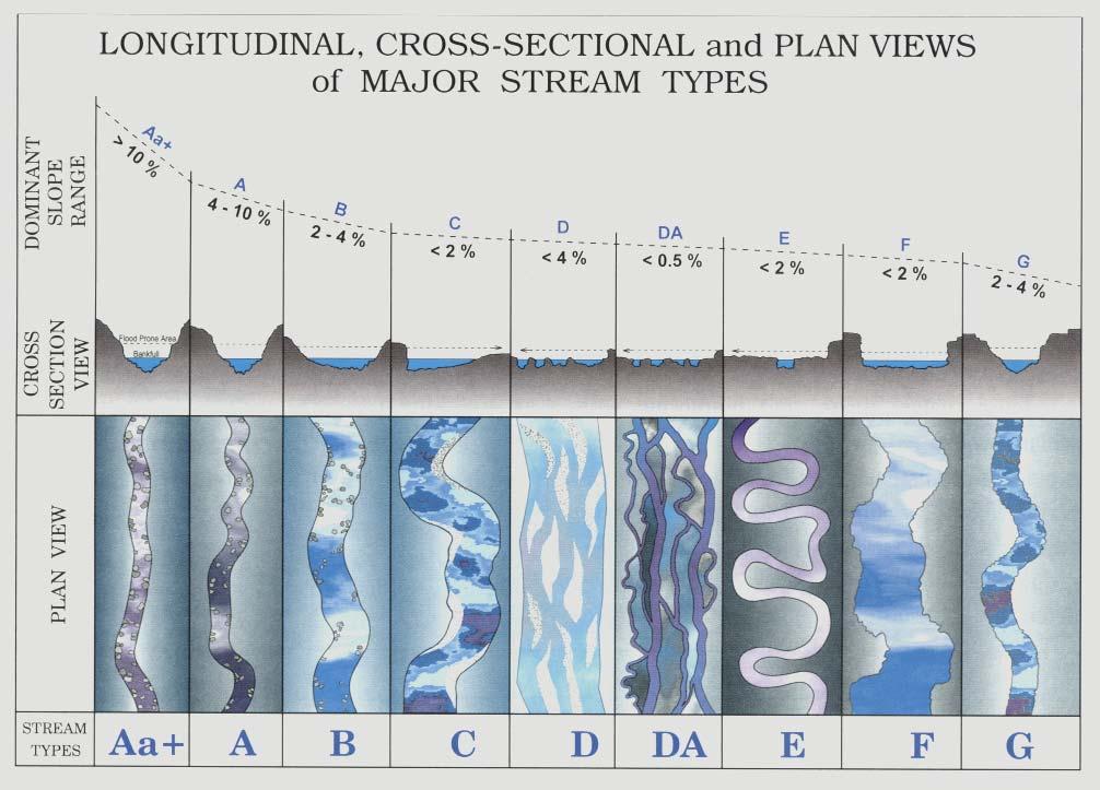
4 Classification Level 1

5 Rosgen (1994) Classification Level II Stream Corridor Restoration: Principles, Processes, and Practices, 1998
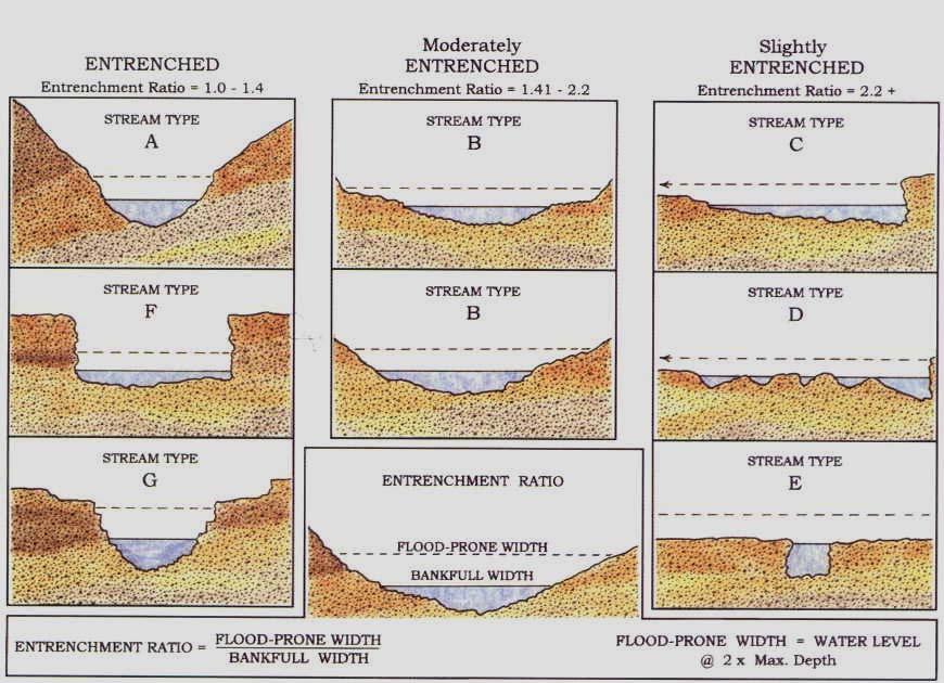
6 Entrenchment Ratio
7 What are the dimensionless ratios for the stable form relative to the specific reach of interest? C Channels B Channels A Channels Wildland Hydrology, 1998 modified 2006

8 Distinct Morphology by Stream Type (i.e, meander belt width)
9 We need to answer these concerns Are we comparing apples to apples?(94 basic geomorphic stream types.) Dimensions applied in stream design are not regionalized. Database and stream design dimensions are lacking.

10 A1a Morphology A1a Trib. to Uncampaghre Valley Type I, Youthful Topography

11 A2 - Yelm, WA Valley Type I, Source

12 A2a on Mission Falls


13 A3a Stream Morphology A3a on Uncampaghre Headwaters

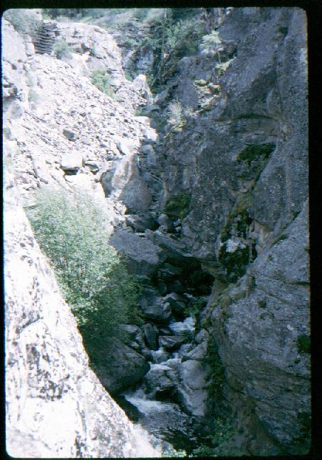
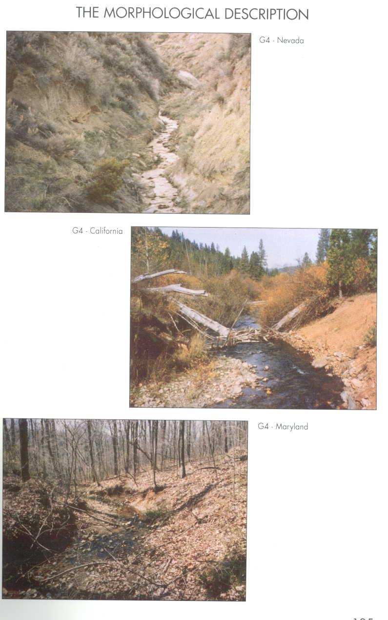
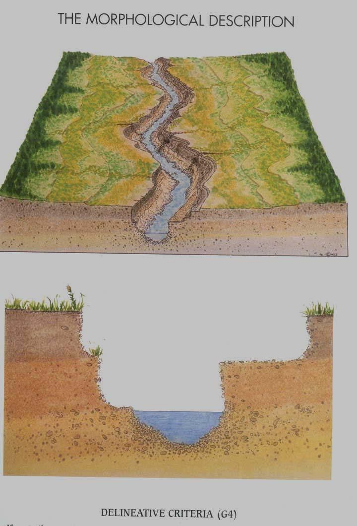
14 A3 less than 10% Slope Cobble Bed, Highly Entrenched, Low Width to Depth Ratio, Low Sinuosity. Sometimes miss-classified as a G stream type.

15 A5 Stream Type


16 Valley Types and Stream Type I Classification A Streams B Streams C and D streams, high gradient C, E, D, F, Gc Type VI, fault control Type V Early Mature Type VIII, Mature
17 Geomorphic Valley Types Youthful Wildland Hydrology, 1996 Early Mature Wildland Hydrology, 1996 What do William Morris Davis (1899) and Dave Rosgen have in common? Old Age Wildland Hydrology, 1996 Old Age Wildland Hydrology, 1996

18 B1 Morphology B Morphology Single Threaded Entrenchment Width to depth Ratio > 12 Sinuosity > 1.2 Slope 2 to 4% B_a Slope range 4 to 10% B_c Slope less than 2%

19 B2 Morphology B2c with a slope less than 2% (0.002ft/ft)

20 B2 Step:Pool Morphology

21 B3 Morphology Cobble Bed


22 B stream Type in Valley Type II Young Valleys Valley Type II

23 B4 Slope 2-4% B4c is very common Slope < 2%

24 Often may have numerous cobbles present but D50 < 64mm B4


25 B5-Sand Very Sensitive to Disturbance
26 B6 Not very common but present in steep loess country

27 B6 forming on Palouse Not Common

28 C Stream Type Morphology Classic Pool:Riffle Morphology Well-Attached Floodplain C3, C4, and C5 are some of the most common stream types
29 Valley Type VIII Multiple Terraces Common valleys for C type streams, sometime Es. However, D, F, and G types can be found depending on stream and riparian conditions

30 C Morphology Single and thread channel Entrenchment Ratio > 2.2 Width:Depth Ratio > 12 Sinuosity > 1.2 Slope, 0.01 to 2% C_b slope 2-4% C_c- slopes < 0.1% Bankfull Elevation C4

31 C Morphology Restored

32 C1 Bedrock control cobbles and boulders present Not a common type

33 C4 Current Stable Analog-North Cascades


34 The C4 Stream Type is a Key Stream Type for Salmonids.


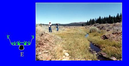
35 C4 Morphology, very common, very important on the landscape

36 C5 Sand Bed

37 C6 Morphology Usually very gentle slopes often associated with lacustrine valley development
38 D4 Braided
39 Braided (DA_) Anastomosed Mature natural stable type braided stream with multiple low width to depth ratio channels, most highly biologically productive per linear stream distance. Often found in estuaries, lacustrine bed very flat valleys and outlets to lakes

40 Braided Anastomosed Is your river an anastomosed braided system or in a highly perturbed braided condition? Braided Aggraded Stehekin Anastomosed

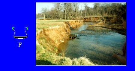
41 E Channel Morphology(at bankfull) Upper Sanpoil River, WA, ER = 19, Average Depth 3.1 feet Average Width 16, Average slope ft/ft, Valley type X E4
42 E Channel Morphology Single Thread channel Entrenchment Ratio > 2.2 Width to Depth Ratio < 12 Sinuosity > 1.5 Slope < 2% E_b, Slope ranges 2-4%, not common
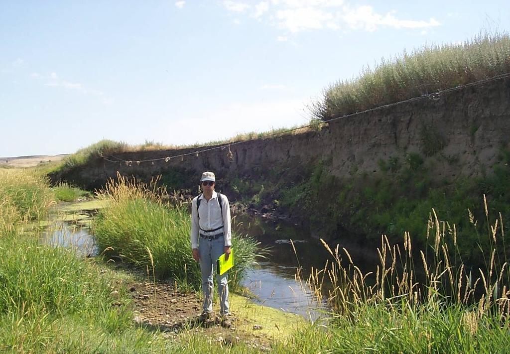
43 Valley Type X: Often E or C

44 E4 Stream Type

45 E3 Channels Not Common but present in high mountain meadows

46 E4 Stream Type

47 E5, Sand Bed

48 F Channel Morphology Highly Entrenched >1.4 High Width to Depth Ratio > 12 Sinuosity > 1.2 Slopes < 2.0% (0.02ft/ft) F_b Slopes, 2 to 4%

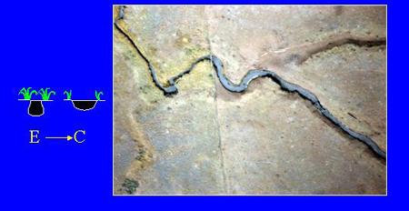
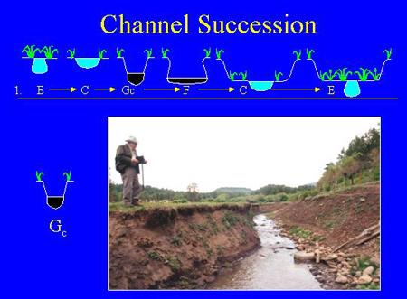
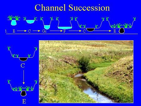
49 Crab Creek F4

50 G Stream Types Entrenchment Ratio < 1.4 Width Depth Ratio < 12 Sinuosity > 1.2 Slope, 2-4% G_c Slopes < 2% Common on Ag. Landscape, Schumm Stage II, Rapid Channel adjustment Floodplain Floodplain G3 Swan Creek, WA
51


52 Before and After Six years and two large floods later

53 Channel Change Adjustments and Evolution


54 Five years Later 1997
55
56 Channel Evolution Model Schumm, Harvey, Watson (1984): = Bankfull Q I Stable Floodplain Q 1.5 Terrace 1 II Incision Q 10 (Headcutting) III Widening +Q 10 (Bank Failure) IV +Q 10 Stabilizing /Deposition V Stable Terrace Floodplain Q 1.5 Terrace 1 Modified by W. Barry Southerland, 2003
57 Floodplain Abandonment Stage I Stage I Schumm Channel Evolution Model and Bank Height Ratio (BHR) WBS, 2002 Stage II WBS, 2002 BHR = Top of the Bank / Bankfull Height. This is a measure of the degree of incision WBS, 2002
58 Bank height ratio This variable is a field measurement that determines the degree of channel incision. It is calculated by dividing the maximum bankfull depth into the height of the lowest bank.

59 Why BHR? BHR > 1.2, early incision begins to show impacts BHR ~ 1.05 Wenas Stream Sanpoil Stream Bankfull
60

61 Slight entrenchment but with meander confinement, Schumm Stage V E4 Channel Bankfull Indicators
62 Aquatic Habitat Response to Stream Type Change
63 Pot. Treat. Opt. Low Banks (<8 ft.) Low Grad. Rosgen Str. Typ. & Schumm CEM Stage Schumm Rosgen Treatment Strategies Typical Practices I Stable C and E for meandering streams Maintain Watershed (W/S) Discharge (Qw), & Sediment (Qs) Maintain riparian Spot Treat. Soil Bio. Stakes, fascines, Rooted stock Whole Plant
64 Pot. Treat. Options Low Banks (<8 ft.), Low Gradient, Rosgen Stream Type & Schumm Schumm Stage II Downcutting and widening Rosgen F & Gc Type CEM Stage Treatment Strategies Reduce W/S Qw & Qs. May need to raise the channel and reconnect floodplain, increase sinuosity (K) and improve riparian Typical Practices Channel realignment and grade control. Use soil bioengineer-ing only with other stability practices
65 Pot. Treat. Options Low Banks (<8 ft.), Low Gradient, Rosgen Stream Type & Schumm CEM Stage Schumm et al. Rosgen Treatment Strategies Typical Practice Early Stage III widening following downcut F Type Reduce W/S Qw. & Qs. May need to excavate (shape) a flood plain & banks for to obtain protection Grading with long term toe protection Soil bioengineer-ing & whole plant transplants
66 Pot. Treat. Options Low Banks (<8 ft.), Low Gradient, Rosgen Stream Type & Schumm CEM Stage Schumm et al. Rosgen Treatment Strategies Typical Practice Late Stage III of Widening F & Bc Maintain existing W/S, Qw & Qs. May need to grade for more flood plain and shape banks for toe protect. & riparian improvement Grading w/ long term toe protection and needed soil bio. no independent soil bio.
67 Pot. Treat. Options Low Banks (<8 ft.), Low Gradient, Rosgen Stream Type & Schumm et al. Stage IV Deposition Schumm CEM Stage Rosgen F & Bc Treatment Strategies Maintain existing W/S Qw & Qs; soil bio. to improve riparian Typical Practice Minor grading and needed soil bioengineer-ing
68 Pot. Treat. Options Low Banks (<8 ft.), Low Gradient, Rosgen Stream Type & Schumm CEM Stage Schumm et al. Rosgen Treatment Strategies Typical Practice Late Stage IV Deposition C & E Maintain existing W/S Qw & Qs; soil bioengineering to improve riparian Minor grading and needed soil bioengineer-ing
69 Pot. Treat. Options Low Banks (<8 ft.), Low Gradient, Rosgen Stream Type & Schumm CEM Stage Schumm et al. Rosgen Treatment Strategies Stage V C & E Maintain existing W/S Qw & Qs; Maintain riparian corridor; May need isolated soil bioengine-ering to improve riparian Typical Practice Spot treatment w/ fascine, live stake w/ rooted stock or grasses

70 Streambank slope relative to structure Photo by WBS, Ohio Creek, CO, 6/2005

71 Thank you. Questions, please? Who s your Mommy now?
Habitat Conditions, Design Strategies,
 Habitat Conditions, Design Strategies, Coho on Cedar Ck. five years after analog-based stream restoration work. and Stream Classification In river work, computer modeling is an insidious procedure in which
Stream Assessment. Date. Data Collected by. Location. Name of Stream and River Basin. Stream Order. Streambank Materials. Streambank Vegetation
 Stream Assessment Date Data Collected by Location Name of Stream and River Basin Stream Order Streambank Materials Streambank Vegetation Floodplain Soils Floodplain Vegetation Valley Type Valley Constraints
Hydraulic Modeling of Stream Enhancement Methods
 Hydraulic Modeling of Stream Enhancement Methods Matthew J. Curry John J. Levitsky Abstract Development within watersheds increases the amounts of runoff causing stream erosion and degradation of stream
TREATING RIVERS RIGHT & EXAMPLES OF BEST USE OF WOOD IN RESTORATION
 TREATING RIVERS RIGHT & EXAMPLES OF BEST USE OF WOOD IN RESTORATION James Mac Cartney, TU River Restoration Specialist John Braico, MD, NY Council Resource Mgr Grassroots Trustee 1 Great Trout Streams
Culvert Design for Low and High Gradient Streams in the Midwest. Dale Higgins, Hydrologist Chequamegon-Nicolet National Forest
 Culvert Design for Low and High Gradient Streams in the Midwest Dale Higgins, Hydrologist Chequamegon-Nicolet National Forest Overview Culvert Design Considerations Hydraulic Terms Culvert Impacts Low
Minnesota Department of Natural Resources Division of Fish and Wildlife Section of Fisheries. Stream Survey Report. Three Mile Creek 2011
 Minnesota Department of Natural Resources Division of Fish and Wildlife Section of Fisheries Stream Survey Report Three Mile Creek 2011 By Joseph D. Stewig Montrose Area Fisheries Office TABLE OF CONTENTS
Fish Habitat Design, Operation and Reclamation Worksheets for
 Fish Habitat Design, Operation and Reclaation Worksheets for Appendix A Project Location Worksheet Applicant Nae: Strea Nae: Watershed Nae: Fish Habitat Suitability Classification Water Quality Zone Operation
Management of headwater streams in the White Mountain National Forest
 Management of headwater streams in the White Mountain National Forest White Mountain National Forest Weeks Act of 1911 authorized the federal government to purchase lands east of the Mississippi River
Report prepared for: Prepared by: January 2002 BEAK Ref
 AQUATIC ENVIRONMENTAL STUDY KANATA WEST CONCEPT PLAN Report prepared for: ROBINSON CONSULTANTS Prepared by: BEAK INTERNATIONAL INCORPORATED 14 Abacus Road Brampton, Ontario L6T 5B7 January 2002 BEAK Ref.
Assessment of Baseline Geomorphic Features at. Proposed Stream Crossings On The Proposed County Road 595. Marquette County, Michigan
 Assessment of Baseline Geomorphic Features at Proposed Stream Crossings On The Proposed County Road 595 Marquette County, Michigan Prepared for: Kennecott Eagle Minerals Company Marquette, Michigan Prepared
Biological Survey of Allagash Stream
 F i"shery Interim Summary Report Series No. 07-04 Biological Survey of Allagash Stream By Forrest R. Bonney Caring for Maine's Outdoor Future September, 2007 Maine Department of Inland Fisheries and Wildlife
Rehabilitation of Grimes Creek, a Stream Impacted in the Past by Bucket-lined Dredge Gold Mining, Boise River Drainage, July 2008 to August 2011.
 Rehabilitation of Grimes Creek, a Stream Impacted in the Past by Bucket-lined Dredge Gold Mining, Boise River Drainage, July 2008 to August 2011. Pam Harrington TU,1020 W. Main Street Suite 440, Boise,
Incorporating Geomorphic Processes and Sediment Dynamics into Salmonid Habitat Restoration Design
 Salmonid Restoration Federation 35 th Annual Salmonid Restoration Conference Davis, CA Incorporating Geomorphic Processes and Sediment Dynamics into Salmonid Habitat Restoration Design Concurrent Session:
Fish Habitat Restoration and Monitoring in Southeast Washington. Andy Hill Eco Logical Research, Inc.
 Fish Habitat Restoration and Monitoring in Southeast Washington Andy Hill Eco Logical Research, Inc. Fish Habitat Restoration and Monitoring in Southeast Washington Talk overview: Restoration projects
STUDY PERFORMANCE REPORT
 STUDY PERFORMANCE REPORT State: Michigan Project No.: F-80-R-4 Study No.: 702 Title: Effects of sediment traps on Michigan river channels Period Covered: October 1, 2002 to September 30, 2003 Study Objectives:
Delaware Basin Stream Management Program
 Delaware Basin Stream Management Program A partnership between NYCDEP and Delaware County Soil & Water Conservation District 2015 Update Delaware Basin - Topics 2015 Project Updates Restoration Projects
Cross-Vane Plan View FIN-UP Habitat Consultants, Inc. 220 Illinois Avenue Manitou Springs, CO (719) P.
 P.") STREAM CHANNEL STRUCTURE DRAWINGS ISIONS W (Channel Width) (Varies) Thalweg & Flow Direction Individually Placed Footer Rocks 5' to 6' by 2' thick (Min. 2 rows of footer rocks placed tightly together with
STREAM CHANNEL STRUCTURE DRAWINGS ISIONS W (Channel Width) (Varies) Thalweg & Flow Direction Individually Placed Footer Rocks 5' to 6' by 2' thick (Min. 2 rows of footer rocks placed tightly together with
Added Introduction: Comparing highway design and stream design
 Added Introduction: Comparing highway design and stream design Highway width is sized for the traffic, the width expanding as volume and speed increase. The ROW width is also designed to handle the speed
Aquatic Organism Passage at Road-Stream Crossings CHUCK KEEPORTS FOREST HYDROLOGIST ALLEGHENY NATIONAL FOREST WARREN, PENNSYLVANIA
 Aquatic Organism Passage at Road-Stream Crossings CHUCK KEEPORTS FOREST HYDROLOGIST ALLEGHENY NATIONAL FOREST WARREN, PENNSYLVANIA TOPICS COVERED Aquatic Organism Passage (AOP) Benefits of AOP Crossings
Minnesota Department of Natural Resources Division of Fish and Wildlife Section of Fisheries. Stream Survey Report. Luxemburg Creek.
 Minnesota F-29-R(P)-24 Area 315 Study 3 March 2016 Minnesota Department of Natural Resources Division of Fish and Wildlife Section of Fisheries Stream Survey Report Luxemburg Creek 2015 Mark Pelham Sauk
Simulating Streams Through Culverts in Mat-Su, Alaska
 Simulating Streams Through Culverts in Mat-Su, Alaska Project Managers Bill Rice, P.E., USFWS Hydrologist Mary Price, USFWS Fishery Biologist The Team Approach US Fish and Wildlife Service Bill Rice, P.E.,
JAP Additional Information Sheet
 JAP Additional Information Sheet Block 15: Purpose and Need The USACE purpose of the project is to provide a safe and reliable whitewater park for the recreational public in a city park, which will provide
Data Report : Russian River Basin Steelhead and Coho Salmon Monitoring Program Pilot Study
 Data Report 1999-1: Russian River Basin Steelhead and Coho Salmon Monitoring Program Pilot Study Sonoma County Water Agency 215 West College Avenue Santa Rosa, California 951 Prepared by David Cook Senior
LONGITUDINAL FIELD METHODOLOGY FOR THE ASSESSMENT OF TMDL SEDIMENT AND HABITAT IMPAIRMENTS
 LONGITUDINAL FIELD METHODOLOGY FOR THE ASSESSMENT OF TMDL SEDIMENT AND HABITAT IMPAIRMENTS Montana Department of Environmental Quality 1520 East Sixth Avenue Helena, Montana 59620 June 2007 TABLE OF CONTENTS
HEC 26 Aquatic Organism Passage Design Manual Evolution & Application
 HEC 26 Aquatic Organism Passage Design Manual Evolution & Application Sven Leon, P.E., Hydraulics Engineer Federal Highway Administration 2015 Alaska Fish Passage Meeting October 13 14, 2015 VTRC, Juneau,
PROJECT TO INSTALL LARGE WOOD HABITAT STRUCTURES IN THE CARMEL RIVER USING CALIFORNIA DEPARTMENT OF FISH AND GAME GRANT FUNDS
 PROJECT TO INSTALL LARGE WOOD HABITAT STRUCTURES IN THE CARMEL RIVER USING CALIFORNIA DEPARTMENT OF FISH AND GAME GRANT FUNDS The Monterey Peninsula Water Management District (MPWMD), in cooperation with
HARRY AND LAURA NOHR CHAPTER OF TROUT UNLIMITED
 HARRY AND LAURA NOHR CHAPTER OF TROUT UNLIMITED BLUE RIVER HABITAT IMPROVEMENT PROJECT 2017 Report Prepared by the Project Committee Harry and Laura Nohr Chapter of Trout Unlimited 1 Sponsorship and Partners
CALIFORNIA SALMONID STREAM HABITAT RESTORATION MANUAL APPENDIX IX-A CULVERT CRITERIA FOR FISH PASSAGE INTRODUCTION
 APPENDIX IX-A STATE OF CALIFORNIA RESOURCES AGENCY DEPARTMENT OF FISH AND GAME CULVERT CRITERIA FOR FISH PASSAGE For habitat protection, ecological connectivity should be a goal of stream-road crossing
USDI Bureau of Land Management Roseburg, Oregon District. Larry Standley Hydrologist Cory Sipher Fisheries Biologist Rick Shockey District Engineer
 USDI Bureau of Land Management Roseburg, Oregon District Larry Standley Hydrologist Cory Sipher Fisheries Biologist Rick Shockey District Engineer 1 Introduction Background why model buoyancy? The buoyant
Mountain Columbia Province
 Rolling Provincial Review: Implementation 2001-2003 Province 229 Columbia Basin Fish & Wildlife Authority Province FY 2001-2003 Spending Summaries NPCC Recommendations and BPA Spending by Project Category,
Hydrologic, Hydraulic and Geomorphic Technical Memorandum
 Appendix A Hydrologic, Hydraulic and Geomorphic Technical Memorandum 01054/8410233/14/Rohner_Alt_Analysis_Report Rohner Creek Flood Control, Habitat and Seismic Improvement Project Alternatives Analysis
Joe Rathbun Michigan DEQ Water Resources Division Nonpoint Source Unit * Thanks to The Nature Conservancy
 Joe Rathbun Michigan DEQ Water Resources Division Nonpoint Source Unit rathbunj@mi.gov * Thanks to The Nature Conservancy Road-stream intersections = 67,511 Culverts = 60,700 Bridges = 6,811 Perched Piping
Climate Change Adaptation and Stream Restoration. Jack Williams;
 Climate Change Adaptation and Stream Restoration Jack Williams; jwilliams@tu.org 1 Goals for this presentation Develop strategies for adapting streams to climate impacts by Thinking like a watershed Understanding
Kootenai River Habitat Restoration Program. Kootenai Tribe of Idaho - January 27, 2014 Presentation for Kootenai Valley Resource Initiative
 Kootenai River Habitat Restoration Program Kootenai Tribe of Idaho - January 27, 2014 Presentation for Kootenai Valley Resource Initiative Decline of native species Kootenai River White Sturgeon ENDANGERED
STREAM SURVEY File form No..
 scanned for KRIS THE RESOURCES AGENCY OF CALIFORNIA California Department of Fish and Game STREAM SURVEY File form No.. Date: September 4, 1969. NAME: North Fork Schooner Gulch Creek COUNTY: Mendocino.
Rock Ramp Design Guidelines. David Mooney MS Chris Holmquist-Johnson MS Drew Baird Ph.D. P.E. Kent Collins P.E.
 Rock Ramp Design Guidelines David Mooney MS Chris Holmquist-Johnson MS Drew Baird Ph.D. P.E. Kent Collins P.E. Rock Ramp Design Guidelines OUTLINE Local and System Interactions with Rock Ramps Ramp Geometry
Minnesota Department of Natural Resources Division of Fish and Wildlife Section of Fisheries. Fairhaven Creek 2000
 Minnesota F-29-R(P)-17 Area 340 Study 3 April 2001 Minnesota Department of Natural Resources Division of Fish and Wildlife Section of Fisheries Stream Survey Report Fairhaven Creek 2000 By Eric R. Altena
APPENDIX J HYDROLOGY AND WATER QUALITY
 APPENDIX J HYDROLOGY AND WATER QUALITY J-1 Technical Report on Airport Drainage, Northern Sector Airport and Ordinance Creek Watershed / Preliminary Creek Constructed Natural Channel Culvert J-2 Preliminary
Trout Unlimited Comments on the Scope of Environmental Impact Statement for the Constitution Pipeline Project, Docket No. PF12-9
 October 9, 2012 Kimberly D. Bose, Secretary Federal Energy Regulatory Commission 888 First Street, NE, Room 1A Washington, DC 20426 RE: Trout Unlimited Comments on the Scope of Environmental Impact Statement
RESTORING THE CONNECTION BETWEEN CREEK AND LAKE: FRESH WATER ESTUARINE CREATION IN MISSISSAUGA
 RESTORING THE CONNECTION BETWEEN CREEK AND LAKE: FRESH WATER ESTUARINE CREATION IN MISSISSAUGA Jeff Doucette, Kenneth Dion and Sally-Beth Betts 6 th International Conference on Natural Channel Systems
Trout Buffer Variance
 Trout Buffer Variance Ashley L. Rodgers, PE Spring 2015 Why a Trout Buffer Capturing pollutants in runoff to keep the water clean. Capturing sediment to keep mud out of the water. Providing shade to keep
Ecology of Place: What salmon need Eric Beamer Skagit River System Cooperative. November 2010
 Ecology of Place: What salmon need Eric Beamer Skagit River System Cooperative November 2010 Acknowledgements NOAA Fisheries NW Fisheries Science Center Tim Beechie George Pess Correigh Greene Talk overview
Ecology - when it comes to river restoration design, so what? Field Trip Guide to Dunham Creek, Blackfoot River Watershed
 Center for Riverine Science and Stream Re-naturalization Fifth Annual Conference Ecology - when it comes to river restoration design, so what? Field Trip Guide to Dunham Creek, Blackfoot River Watershed
Massachusetts Stream Crossing Case Studies
 Massachusetts Stream Crossing Case Studies Amy Singler Associate Director, River Restoration Program Carrie Banks River Continuity Coordinator Case Studies: Public Benefits: Movement of goods and people
Minnesota Department of Natural Resources Division of Fish and Wildlife Section of Fisheries. Stream Survey Report. St. Francis River 2004
 Minnesota F-29-R(P)-17 Area 315 Study 3 April 2005 Minnesota Department of Natural Resources Division of Fish and Wildlife Section of Fisheries Stream Survey Report St. Francis River 2004 By Eric R. Altena
MCCAW REACH RESTORATION
 Final Report MCCAW REACH FISH RESTORATION PHASE B Jack McCaw Inland Empire Action Coalition http://www.wwccd.net/ Phone: 509-956-3777 Hours: 8:00-4:30 Walla Walla County Conservation District Snake River
Presented by Fred Halterman, URS Jennie Agerton, URS
 Presented by Fred Halterman, URS Jennie Agerton, URS What is Eco Friendly Culvert Design? Culvert design that: Maintains connectivity for aquatic organism migration Maintains connectivity for gene flow
Mid-Columbia Fisheries Enhancement Group Annual Report Fiscal Year 06: July 1, 2005 June 30, 2006
 Mid-Columbia Fisheries Enhancement Group Annual Report Fiscal Year 06: July 1, 2005 June 30, 2006 Mission Statement The mission of the Mid-Columbia Fisheries Enhancement Group is to restore self-sustaining
Quantifying Performance of Stream Simulation Culverts in the Chehalis Basin, WA
 Quantifying Performance of Stream Simulation Culverts in the Chehalis Basin, WA AUTHORS: Joe Richards, Environmental Science Associates Jane Atha, Washington Department of Fish & Wildlife Colin Thorne,
Level II Stream Survey for the Timberline Express Proposal
 TECHNICAL MEMORANDUM 24 146th Place SE Suite 6 Bellevue WA 987 Tel: 42.6.69 Fax: 42.6.694 www.segrp.com TO: FROM: CC: Bill Granger Travis Spikes Timberline Express EIS project folder DATE: October 21,
(Revised February,2005) CULVERTS, BRIDGES, AND FORDS
 CULVERTS, BRIDGES, AND FORDS") GUIDE TO STREAM CROSSINGS (Revised February,2005) CULVERTS, BRIDGES, AND FORDS Culverts, bridges, and fords are all methods used to cross-streams. Culverts are the most common stream crossing structure.
GUIDE TO STREAM CROSSINGS (Revised February,2005) CULVERTS, BRIDGES, AND FORDS Culverts, bridges, and fords are all methods used to cross-streams. Culverts are the most common stream crossing structure.
APPENDIX C VEGETATED EMERGENCY SPILLWAY. VERSION 1.0 March 1, 2011
 APPENDIX C VEGETATED EMERGENCY SPILLWAY VERSION 1.0 March 1, 2011 [NOTE: Could use a better photo more clearly showing the emergency spillway in the context of the dam.] SECTION C-1: DESCRIPTION OF PRACTICE
Stevens Creek Corridor
 O F F I C E O F T H E D I R E C T O R O F P U B L I C W O R K S Stevens Creek Corridor Creek Restoration Project Volume Three Project Update: Creek Photos, Before & After BY GAIL SEEDS - PROJECT MANAGER,
Water surface slope extending up to 20 channel widths up and downstream of crossing.
 Site Evaluations Site Information Site Location: Mt ood NF, Forest Road 7 Year Installed: Pre-987 Lat/Long: 8 W Watershed rea (mi ): N Stream Slope (ft/ft) : Channel Type: Step-pool ankfull Width (ft):
DRAFT. Stonybrook Creek Watershed
 DRAFT Stonybrook Creek Watershed A Strategic Plan for Eliminating Barriers to Steelhead Migration June 4, 2010 Prepared by: PO Box 4477, Arcata, CA 95518 mlove@h2odesigns.com / (707) 476 8938 Prepared
Big Spring Creek Habitat Enhancement and Fishery Management Plans
 Big Spring Creek Habitat Enhancement and Fishery Management Plans November 5, 2012 Big Spring Events and Activities Center Newville, PA Charlie McGarrell Regional Habitat Biologist Pennsylvania Fish and
Suitable Applications Check dams may be appropriate in the following situations: To promote sedimentation behind the dam.
 Categories EC Erosion Control SE Sediment Control TC Tracking Control WE Wind Erosion Control Non-Stormwater NS Management Control Waste Management and WM Materials Pollution Control Legend: Primary Category
P.O. Box 65 Hancock, Michigan USA fax
 This PDF file is a digital version of a chapter in the 2005 GWS Conference Proceedings. Please cite as follows: Harmon, David, ed. 2006. People, Places, and Parks: Proceedings of the 2005 George Wright
Creation of Fish and Wildlife Habitat on the Closed Salmon Harbour Mine in Minto, NB
 Creation of Fish and Wildlife Habitat on the Closed Salmon Harbour Mine in Minto, NB M. Coleman 1, R. Rutherford 2, RA Currie 3 1 NB Power 2 Thaumas Environmental Consultants Ltd 3 RA Currie Ltd. Location
OFFICE OF STRUCTURES MANUAL FOR HYDROLOGIC AND HYDRAULIC DESIGN CHAPTER 13 CULVERTS APRIL 2011
 OFFICE OF STRUCTURES MANUAL FOR HYDROLOGIC AND HYDRAULIC DESIGN CHAPTER 13 CULVERTS APRIL 2011 APRIL 2011 Chapter 13 Culverts Table of Contents Foreword.3 13.1 Introduction.. 4 13.2 Policy 6 13.3 Passage
Tips for Using & Printing Spreadsheets
 Key to Spreadsheets Spreadsheet # Type Description/Purpose a Development & Construction in Waterways b Debits Development & Construction in Other Aquatic Areas c Indirect Impacts to Waterways from Development
Fish Passage Culvert Assessment for Cahilty Creek Watershed FIA Project #
 Fish Passage Culvert Assessment for Cahilty Creek Watershed FIA Project # 4602004 Prepared for Weyerhaeuser Company Ltd. Jason Ladyman R.P.F. 1550 Mission Flats Road PO Box 40 Kamloops BC V2C 5K3 Prepared
San Lorenzo Valley Water District, Watershed Management Plan, Final Version Part I: Existing Conditions Report
 LIST OF FIGURES Figure 1-1. Map of the San Lorenzo River watershed Figure 2-1. The Santa Cruz Mountains Bioregion Figure 2-2. Protected areas within the San Lorenzo River watershed Figure 2-3. Primary
APPENDIX C ESTIMATING SCOUR IN BOTTOMLESS ARCH CULVERTS
 OFFICE OF STRUCTURES MANUAL FOR HYDROLOGIC AND HYDRAULIC DESIGN CHAPTER 11, EVALUATING SCOUR AT BRIDGES APPENDIX C ESTIMATING SCOUR IN BOTTOMLESS ARCH CULVERTS APRIL 2011 APPENDIX C ESTIMATING SCOUR IN
East Fork Jemez River Stream Inventory Report Santa Fe National Forest Jemez Ranger District Surveyed July to September 2001 Forest Fisheries Crew
 East Fork Jemez River Stream Inventory Report Santa Fe National Forest Jemez Ranger District Surveyed July to September 2001 Forest Fisheries Crew Report By James Simino Fisheries Biologist Reviewed By
Low Gradient Velocity Control Short Term Steep Gradient Channel Lining Medium-Long Term Outlet Control Soil Treatment Permanent [1]
![Low Gradient Velocity Control Short Term Steep Gradient Channel Lining Medium-Long Term Outlet Control Soil Treatment Permanent [1]](/thumbs/80/80811988.jpg "Low Gradient Velocity Control Short Term Steep Gradient Channel Lining Medium-Long Term Outlet Control Soil Treatment Permanent [1]") Check Dams DRAINAGE CONTROL TECHNIQUE Low Gradient Velocity Control Short Term Steep Gradient Channel Lining Medium-Long Term Outlet Control Soil Treatment Permanent [1] [1] Though not generally considered
Check Dams DRAINAGE CONTROL TECHNIQUE Low Gradient Velocity Control Short Term Steep Gradient Channel Lining Medium-Long Term Outlet Control Soil Treatment Permanent [1] [1] Though not generally considered
FINAL REPORT. Yonkers Creek Migration Barrier Removal Project Wonderstump Road Del Norte County. Submitted By:
 FINAL REPORT Yonkers Creek Migration Barrier Removal Project Wonderstump Road Del Norte County Submitted By: Del Norte County Community Development Department Yonkers Creek Migration Barrier Removal Project
Understanding the Impacts of Culvert Performance on Stream Health
 Understanding the Impacts of Culvert Performance on Stream Health Kristin Thomas Aquatic Ecologist Michigan Trout Unlimited Transportation and the Environment Conference 12/5/2018 Importance of adequately
CHAPTER 4 DESIRED OUTCOMES: VISION, GOALS, AND OBJECTIVES
 CHAPTER 4 DESIRED OUTCOMES: VISION, GOALS, AND OBJECTIVES Vision One of the first steps in developing this Plan was articulating a vision - a clear statement of what the Plan strives to achieve and what
Assessing Ecosystem Impacts from Road Stream Crossings through Community Involvement
 Assessing Ecosystem Impacts from Road Stream Crossings through Community Involvement Background Why is the NH Fish and Game Department interested in culverts? Block fish migration Reduce opportunities
What happens to Oregon s tidal wetlands with sea level rise?
 What happens to Oregon s tidal wetlands with sea level rise? Laura Brophy Estuary Technical Group Institute for Applied Ecology Corvallis, OR Laura@appliedeco.org Project maps future tidal wetlands, predicts
OKANAGAN RIVER RESTORATION INITIATIVE - FAQ
 OKANAGAN RIVER RESTORATION INITIATIVE - FAQ Initiative background: The health of the q awsitk w (Okanagan River) has been severely impacted by the channelization works that occurred in the mid-1950 s.
RESILIENCE THROUGH RESTORATION
 RESILIENCE THROUGH RESTORATION RECLAMATION DISTRICT NO. 1601 TWITCHELL ISLAND SAN JOAQUIN RIVER SETBACK LEVEE PROJECT TWITCHELL ISLAND BASICS Nearly 12 miles of levee Storm drainage facilities Protects
Limiting Factors Assessment and Restoration Plan. Bear Creek
 Limiting Factors Assessment and Restoration Plan Bear Creek A Tributary to Salmon River January 2009 Prepared by Bio-Surveys, LLC P.O. Box 65 Alsea, OR 97324 541-487-4338 Contact: Steve Trask, Mary Holbert
STREAM CLASSIFICATION AND MAPPING. Prepared For. MacMillan Bloedel Ltd. Menzies Bay Division BOX 6000, Campbell River V9W 5E1.
 STREAM CLASSIFICATION AND MAPPING OF STREAMS IN MENZIES AND OYSTER BAY Prepared For MacMillan Bloedel Ltd. Menzies Bay Division BOX 6000, Campbell River V9W 5E1 September 1998 a a North Island Biological
Redd Dewatering and Juvenile Salmonid Stranding in the Lower Feather River,
 Redd Dewatering and Juvenile Salmonid Stranding in the Lower Feather River, 2005-2006 Interim Report for NOAA Fisheries Prepared by: California Department of Water Resources Division of Environmental Services
Illinois Lake Management Association Conference March 23, 2018 By Trent Thomas Illinois Department of Natural Resources Division of Fisheries
 Illinois Lake Management Association Conference March 23, 2018 By Trent Thomas Illinois Department of Natural Resources Division of Fisheries Sources of Habitat Impairment Sedimentation Channelization
Restoring the Kootenai: A Tribal Approach to Restoration of a Large River in Idaho
 Restoring the Kootenai: A Tribal Approach to Restoration of a Large River in Idaho Susan Ireland, Kootenai Tribe of Idaho Future of our Salmon Conference Technical Session August 2016 Healthy Floodplains,
COA-F17-F-1343 YEAR END REPORT
 DAVE MARSHALL SALMON RESERVE RESTORATION, MAINTENANCE, AND UPGRADES YEAR END REPORT Prepared for: Fish and Wildlife Compensation Program Prepared by: Edith Tobe, RPBio, Executive Director Box 1791, Squamish,
Identifying Areas with Potential to Contain High Value Fish Habitat (HVFH) June 2007
 June 2007") Identifying Areas with Potential to Contain High Value Fish Habitat (HVFH) June 2007 1 High Value Fish Habitat INTENT: To apply added precautionary protection to those special areas deemed of high value
Identifying Areas with Potential to Contain High Value Fish Habitat (HVFH) June 2007 1 High Value Fish Habitat INTENT: To apply added precautionary protection to those special areas deemed of high value
USING A LABYRINTH WEIR TO INCREASE HYDRAULIC CAPACITY. Dustin Mortensen, P.E. 1 Jake Eckersley, P.E. 1
 USING A LABYRINTH WEIR TO INCREASE HYDRAULIC CAPACITY Dustin Mortensen, P.E. 1 Jake Eckersley, P.E. 1 Plum Creek Floodwater Retarding Structure No. 6 is located in an area of Kyle, Texas, that is currently
Great Lakes Stream Crossing Inventory Instructions
 Great Lakes Stream Crossing Inventory Instructions This document is a guide to completing the Stream Crossing Data Sheet (2/28/11 version). Careful attention to this guidance will ensure consistent crossing
Trout Habitat Improvements On Hay Creek
 Trout Habitat Improvements On Hay Creek Jason Peterson "When we try to pick out anything by itself, we find it is hitched to everything else in the universe." - John Muir - Instream habitat for trout in
Five Counties Salmonid Conservation Program - Fish Passage Design Workshop. February 2013
 Program - Aquatic Organisms and Stream Crossings Ecological Connectivity A watershed is a network of channels that drain a common boundary. Channel characteristics formed by interaction of precipitation,
Salmon Run G.C. Hole 3: Tributary & Wetland Restoration
 Salmon Run G.C. Hole 3: Tributary & Wetland Restoration Preliminary Project Design December 23, 2014 Prepared By: Curry Soil and Water Conservation District & Swanson Ecological Services, LLC Project Location:
Eastern Brook Trout. Roadmap to
 Eastern Brook Trout Roadmap to CONSERVATION Our Brook Trout heritage he wild Brook Trout is an American symbol of persistence, adaptability, and the pristine wilderness that covered North America prior
Lecture 1 Why Do We Have Levees in Louisiana? J. David Rogers, Ph.D., P.E., R.G.
 Lecture 1 Why Do We Have Levees in Louisiana? J. David Rogers, Ph.D., P.E., R.G. Karl F. Hasselmann Chair in Geological Engineering Missouri University of Science & Technology for the First Annual Levee
REC 6 FISHERIES HABITAT EVALUATION
 REC 6 FISHERIES HABITAT EVALUATION 1.0 EXECUTIVE SUMMARY Analysis of fisheries habitat for recreational angling opportunities was completed by reviewing the results of the CAWG 1, Characterize Stream and
Isar Plan in Munich,Bavaria Flood Protection, Restoration, Recreation
 Isar Plan in Munich,Bavaria Flood Protection, Restoration, Recreation Dr. Klaus Arzet AGENDA Isar-Plan: history and concept Principle approach and measures: Learning by doing and lessons learnt Conclusions
Habitat Assessment of the Lower Eklutna River. May 14, 2007
 Habitat Assessment of the Lower Eklutna River May 14, 2007 Prepared For: United States Army Corps of Engineers Civil Works Branch Environmental Resource Section P.O. Box 6898 Elmendorf AFB, AK 99506-0898
Overview of the Trinity River
 Overview of the Trinity River The Trinity River The Trinity River begins in the rugged Trinity Alps in northwestern California. On its journey, it tumbles through steep canyons and meanders through broad
FISH PASSAGE IMPROVEMENT in California s Watersheds. Assessments & Recommendations by the Fish Passage Forum
 FISH PASSAGE IMPROVEMENT in California s Watersheds Assessments & Recommendations by the Fish Passage Forum FISH PASSAGE IMPROVEMENT in California s Watersheds The mission of the Fish Passage Forum is
SELBY CREEK SILVERADO TRAIL CULVERT FISH PASSAGE ASSESSMENT
 SELBY CREEK SILVERADO TRAIL CULVERT FISH PASSAGE ASSESSMENT NAPA COUNTY, CALIFORNIA PREPARED BY NAPA COUNTY RESOURCE CONSERVATION DISTRICT 1303 JEFFERSON ST. SUITE 500B NAPA, CALIFORNIA 94559 WWW.NAPARCD.ORG
5B. Management of invasive species in the Cosumnes and Mokelumne River Basins
 5B. Management of invasive species in the Cosumnes and Mokelumne River Basins Cosumnes River The Cosumnes River basin has a number of distinct habitat types that require different management strategies
Fish Passage Assessment of Private Stream Crossings on Lower Stonybrook Creek
 Fish Passage Assessment of Private Stream Crossings on Lower Stonybrook Creek Prepared by: Michael Love & Associates In cooperation with: Center for Ecosystem Management and Restoration Funded by: Coastal
APPENDIX B HYDRAULIC DESIGN DATA FOR CULVERTS
 TM 5-820-4/AFM 88-5, Chap 4 APPENDIX B HYDRAULIC DESIGN DATA FOR CULVERTS B-1. General. a. This appendix presents diagrams, charts, coefficients and related information useful in design of culverts. The
Stream Assessment Cut-block: For: Island Timberlands Limited Partnership, Cameron Operation
 Stream Assessment Cut-block: 171214 For: Island Timberlands Limited Partnership, Cameron Operation Tony Norris Area Engineer Island Timberlands Cameron Operation Port Alberni D.G. Rigets E.I.A. CTech.
3.0 Basin and Watershed Characteristics
 3.0 Basin and Watershed Characteristics 3.1 Basin Characteristics 3.1.1 Crystal Lake Crystal Lake, located in the cities of Burnsville and Lakeville (Dakota County), covers an area of approximately 292
FISH HABITAT ASSESSMENT IN THE OREGON DEPARTMENT OF FORESTRY MIAMI STUDY AREA
 FISH HABITAT ASSESSMENT IN THE OREGON DEARTMENT OF FORESTRY MIAMI STUDY AREA July 11, 2005 eggy Kavanagh Charlie Stein Andy Talabere Kim Jones Oregon Department of Fish and Wildlife Aquatic Inventories
Minnesota Department of Natural Resources Division of Fish and Wildlife Section of Fisheries. Stream Survey Report. Cold Spring Creek.
 Minnesota F-29-R(P)-24 Area 315 Study 3 March 2013 Minnesota Department of Natural Resources Division of Fish and Wildlife Section of Fisheries Stream Survey Report Cold Spring Creek 2012 Mark Pelham Montrose