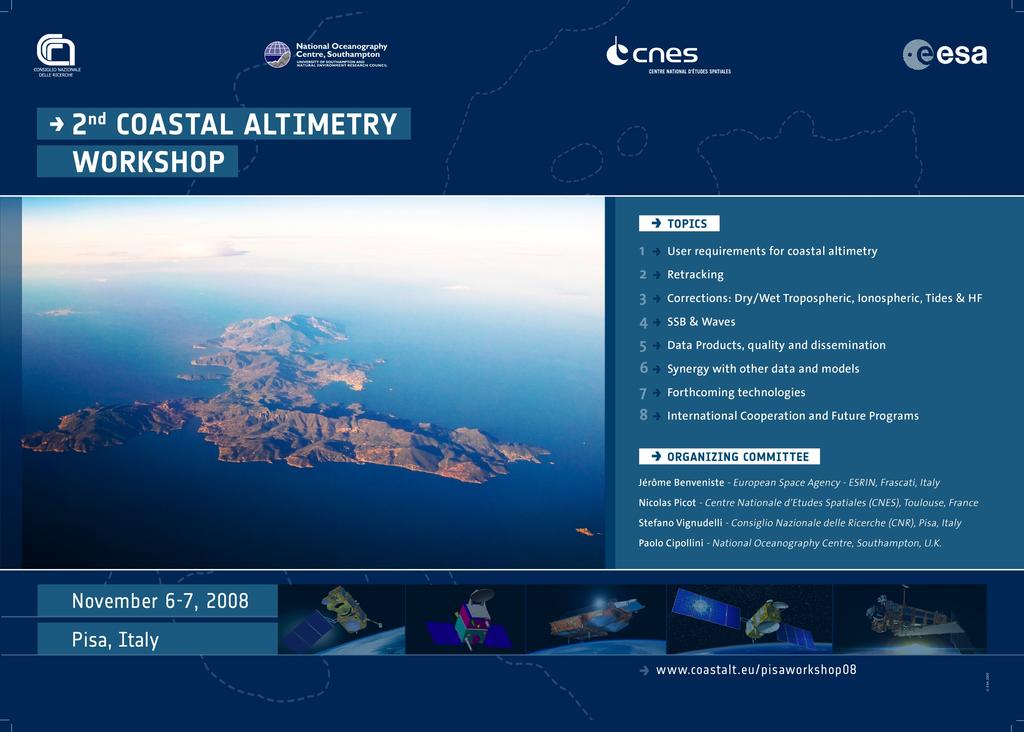
Take home messages from the 2 nd Coastal Al6metry Workshop
|
|
|
- Dylan Welch
- 6 years ago
- Views:
Transcription
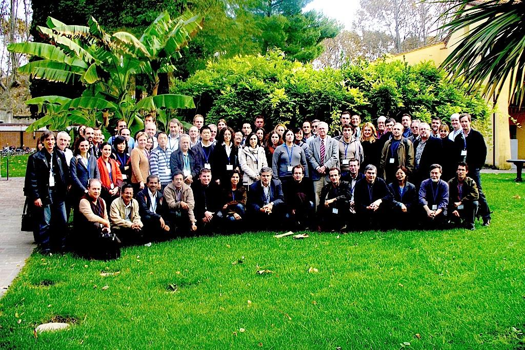
1 Take home messages from the 2 nd Coastal Al6metry Workshop Paolo Cipollini Na6onal Oceanography Centre, Southampton Co chairs: Stefano Vignudelli, Jérôme Benveniste, Nicolas Picot Moderators: Peter Challenor, Claire Dufau, William Emery, Chris6ne Gommenginger, Sylvie Labroue, Franck Mercier, Estelle Obligis, Cris6na Mar6n Puig, Keith Raney, Remko Scharroo, Walter Smith, Helen Snaith, Ted Strub, Phil Woodworth
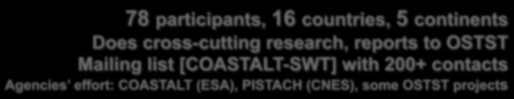
2 1) Coastal al6metry is inherently interdisciplinary Need constant interac6on with hydrographers, modellers, in situ scien6sts on the applica6on side, engineers on the technical side Can t walk alone BUT it is perceived as prezy legi6mate (and very useful) component of coastal observing systems (and, yes, we are now confident we can recover 15+ years of data ) RECOMMENDATION: we need to reach out to more (potential) users
3 2) Coastal al6metry research feeds back into open ocean al6metry Most (if not all) Cal/Val sites are coastal! It is a useful training ground to tackle many instrumental and geophysical correc6on problems. Challenges all elements of the al6metry system and encourages/mo6vates a revisit of not completely solved problems example: SSB
4 3) Very promising improvements on tracking/retracking DIODE/DEM on J2 looks good (but on board DEMs are not so good) RECOMMENDATION: put higher resolution DEMs on future missions Retracking: several different algorithms being implemented and tested (like those in the PISTACH and COASTALT processors) RECOMMENDATION: we need proper validation/intercomparison of retrackers (incl. assessing biases)


 J2 DIODE DEM (cycle 7)")

5 Jason-1/Jason-2 comparison on coastal zones : P187 on med. sea From land to ocean On islands From ocean to land J1 (cycle 240) J2 Median (cycle 8) J2 DIODE DEM (cycle 7) Coastal Al6metry Workshop Pisa Italy November 2008 P.Thibaut et al, CLS
6 3) Very promising improvements on tracking/retracking DIODE/DEM on J2 looks good (but on board DEMs are not so good) RECOMMENDATION: put higher resolution DEMs on future missions Retracking: several different algorithms being implemented and tested (like those in the PISTACH and COASTALT processors) RECOMMENDATION: we need proper validation/intercomparison of retrackers (incl. assessing biases)
7 4) Very promising improvements on correc6ons Wet tropospheric Land decontamina6on (CLS: opera6onal PISTACH algorithm; JPL: new approach) GPS derived (U Porto; accurate but needs extending globally) MODIS derived useful for comparison (cloud free) Ionospheric Recomputed from dual freq. re tracked ranges GIM
8 4) Very promising improvements on correc6ons (cont.) Tides Recent progress (GOT 4.7, EOT08a) promising Need more work on local models IB/HF Form collec6ons of outputs from local models using extensive local exper6se RECOMMENDATION: need better bathymetry (1km or even 200m, global) For all correc6ons, we need to quan6fy improvement on a regional basis
9 5) Products are coming out! Jason 2: PISTACH v1.0 L2 products available First pass (cy 12 tr 4) released last Friday Envisat: COASTALT products over selected pass in 3 test areas (NW Med, W Britain, W Iberia) in Spring 2009 Fully expandable (users can easily add local/new fields) In parallel, new ideas for data distribu6on (such as Web Services JPL) Future: Reprocess all missions? NRT data?
10
11 Summary of 1 st WS Links to all presenta6ons Summary of 2 nd WS (DRAFT comments are welcome!) Links to all presenta6ons (in a few days) Links to project ac6vi6es, research, documenta6on Links to datasets (as soon as available) To be added to the mailing list, e mail cipo@noc.soton.ac.uk
12
ERS WAVE MISSION REPROCESSING- QC SUPPORT ENVISAT MISSION EXTENSION SUPPORT
 REPORT 8/2011 ISBN 978-82-7492-248-8 ISSN 1890-5218 ERS WAVE MISSION REPROCESSING- QC SUPPORT ENVISAT MISSION EXTENSION SUPPORT - Annual Report 2010 Author (s): Harald Johnsen (Norut), Fabrice Collard
ERS-1/2 Scatterometer new products: mission reprocessing and data quality improvement
 ERS-1/2 Scatterometer new products: mission reprocessing and data quality improvement Giovanna De Chiara (1), Raffaele Crapolicchio (1), Pascal Lecomte (2) (1) Serco SpA Via Sciadonna 22-24 Frascati (Roma),
EVALUATION OF ENVISAT ASAR WAVE MODE RETRIEVAL ALGORITHMS FOR SEA-STATE FORECASTING AND WAVE CLIMATE ASSESSMENT
 EVALUATION OF ENVISAT ASAR WAVE MODE RETRIEVAL ALGORITHMS FOR SEA-STATE FORECASTING AND WAVE CLIMATE ASSESSMENT F.J. Melger ARGOSS, P.O. Box 61, 8335 ZH Vollenhove, the Netherlands, Email: info@argoss.nl
Coastal Scatterometer Winds Working Group
 Coastal Scatterometer Winds Working Group IOVWST Meeting 2015 Portland, Oregon, USA Melanie Fewings Julia Figa Saldaña Bryan Stiles Steve Morey Dmitry Dukhovskoy Larry O Neill if you want to be added to
Validation of 12.5 km and Super-High Resolution (2-5 km)
") Coastal and Orographic Wind Analyses from High Resolution QuikSCAT and SeaWinds Measurements M.H. Freilich, COAS/OSU D.B. Chelton, COAS/OSU D.G. Long, BYU Clive Dorman, SIO Barry Vanhoff, COAS/OSU OVWST
Coastal and Orographic Wind Analyses from High Resolution QuikSCAT and SeaWinds Measurements M.H. Freilich, COAS/OSU D.B. Chelton, COAS/OSU D.G. Long, BYU Clive Dorman, SIO Barry Vanhoff, COAS/OSU OVWST
1 st Tidal and Water Level Working Group Meeting DHN, Niteroi, Brazil 31/03/09 02/04/09 Vertical Offshore Reference Framework (VORF) Chris Jones
 Chris Jones") 1 st Tidal and Water Level Working Group Meeting DHN, Niteroi, Brazil 31/03/09 02/04/09 Vertical Offshore Reference Framework (VORF) Chris Jones United Kingdom Hydrographic Office Presentation Structure
1 st Tidal and Water Level Working Group Meeting DHN, Niteroi, Brazil 31/03/09 02/04/09 Vertical Offshore Reference Framework (VORF) Chris Jones United Kingdom Hydrographic Office Presentation Structure
Recovery of sea level fields of the last decades from altimetry and tide gauge data
 Recovery of sea level fields of the last decades from altimetry and tide gauge data Francisco M. Calafat, Damià Gomis, Ananda Pascual, Marta Marcos and Simón Ruiz Mediterranean Institute for Adavanced
Evaluation of MODIS chlorophyll algorithms in
 Evaluation of MODIS chlorophyll algorithms in Australian continental shelf waters: The IMOS match up data base Schroeder T, Lovell J,, Clementson L, King E, Brando V 9 July 2014 Australian Marine Science
MIKE 21 Toolbox. Global Tide Model Tidal prediction
 MIKE 21 Toolbox Global Tide Model Tidal prediction MIKE Powered by DHI 2017 DHI headquarters Agern Allé 5 DK-2970 Hørsholm Denmark +45 4516 9200 Telephone +45 4516 9333 Support +45 4516 9292 Telefax mike@dhigroup.com
SENSOR SYNERGY OF ACTIVE AND PASSIVE MICROWAVE INSTRUMENTS FOR OBSERVATIONS OF MARINE SURFACE WINDS
 SENSOR SYNERGY OF ACTIVE AND PASSIVE MICROWAVE INSTRUMENTS FOR OBSERVATIONS OF MARINE SURFACE WINDS N. Ebuchi Institute of Low Temperature Science, Hokkaido University, N19-W8, Kita-ku, Sapporo 060-0819,
GNSS Technology for the Determination of Real-Time Tidal Information
 GNSS Technology for the Determination of Real-Time Tidal Information Benjamin Kidder C-Nav Positioning Solutions European region Outline of Topics Covered Introduction to Tides Past and Present Methods
HIGH RESOLUTION WIND AND WAVE MEASUREMENTS FROM TerraSAR-X IN COMPARISON TO MARINE FORECAST
 SAR Maritime Applications German Aerospace Center (DLR) Remote Sensing Technology Institute Maritime Security Lab HIGH RESOLUTION WIND AND WAVE MEASUREMENTS FROM TerraSAR-X IN COMPARISON TO MARINE FORECAST
Pathogen Transport in Coastal Environments: Case Studies of Urban Runoff in Southern California
 Pathogen Transport in Coastal Environments: Case Studies of Urban Runoff in Southern California A presentation to the Center for Water Sciences MSU Pathogens Workshop, April 20, 2007 Stanley B. Grant Henry
Evaluation of the Klein HydroChart 3500 Interferometric Bathymetry Sonar for NOAA Sea Floor Mapping
 Evaluation of the Klein HydroChart 3500 Interferometric Bathymetry Sonar for NOAA Sea Floor Mapping Yuhui Ai, Straud Armstrong and Dean Fleury L-3 Communications Klein Associates, Inc. 11 Klein Dr. Salem,
Wave Transformation, Prediction, and Analysis at Kaumalapau Harbor, Lanai, Hawaii
 Wave Transformation, Prediction, and Analysis at Kaumalapau Harbor, Lanai, Hawaii Jessica H. Podoski, P.E. Coastal Engineer, USACE Honolulu District Christopher Goody, P.E. Sea Engineering, Inc. Thomas
Advancements in scatterometer wind processing
 Advancements in scatterometer wind processing Ad.Stoffelen@knmi.nl Marcos Portabella Anton Verhoef Jeroen Verspeek Jur Vogelzang scat@knmi.nl www.knmi.nl/scatterometer Scatterometer work The scatterometer
using GPS radio occultation data
 Tropopause altitude identification using GPS radio occultation data Huw Lewis, FORMOSAT-3/COSMIC Data Users Workshop, Boulder. 27 October 2009 Outline Tropopause measurements Radio Occultation data Results
PACIFIC BLUEFIN TUNA STOCK ASSESSMENT
 PACIFIC BLUEFIN TUNA STOCK ASSESSMENT SUMMARY 19-21 December 2012 Webinar PACIFIC BLUEFIN TUNA STOCK ASSESSMENT SUMMARY 1. Stock Identification and Distribution Pacific bluefin tuna (Thunnus orientalis)
LAMPEDUSA C B TRIPOLI
 ITALY SRR LAMPEDUSA 0 60 120 KILOMETERS MALTA SRR NATO MARITIME SURVEILLANCE AREA AS OF MARCH 23, 2011 D C B NATO MARITIME SURVEILLANCE AREA AS OF APRIL 8, 2011 A LIBYA SRR E TRIPOLI EXCERPT FROM: REPORT
Contribution of French research teams to ADM Cal/Val
 Contribution of French research teams to ADM Cal/Val A. Dabas, Météo-France J.P. Cammas (OSUR), P. Chazette (LSCE), A. Hauchecorne (LATMOS), A. Hertzog (LMD), F. Gibert (LMD), J. Pelon (LATMOS) ESA UNCLASSIFIED
High resolution wind fields over the Black Sea derived from Envisat ASAR data using an advanced wind retrieval algorithm
 High resolution wind fields over the Black Sea derived from Envisat ASAR data using an advanced wind retrieval algorithm Werner Alpers (1), Alexis Mouche (2), Andrei Yu. Ivanov (3), and Burghard Brümmer
Reprocessed QuikSCAT (V04) Wind Vectors with Ku-2011 Geophysical Model Function
 Wind Vectors with Ku-2011 Geophysical Model Function") Reprocessed QuikSCAT (V04) Wind Vectors with Ku-2011 Geophysical Model Function Lucrezia Ricciardulli and Frank Wentz Introduction In April 2011, we reprocessed the QuikSCAT ocean wind vectors using a
Reprocessed QuikSCAT (V04) Wind Vectors with Ku-2011 Geophysical Model Function Lucrezia Ricciardulli and Frank Wentz Introduction In April 2011, we reprocessed the QuikSCAT ocean wind vectors using a
Real Time (RT) Snow Water Equivalent (SWE) Simulation April 14, 2014 Sierra Nevada Mountains, California
 Snow Water Equivalent (SWE) Simulation April 14, 2014 Sierra Nevada Mountains, California") Real Time (RT) Snow Water Equivalent (SWE) Simulation April 14, 2014 Sierra Nevada Mountains, California Abstract On April 14 th, percent of average SWE values for this date have decreased to 10% for the
Real Time (RT) Snow Water Equivalent (SWE) Simulation April 14, 2014 Sierra Nevada Mountains, California Abstract On April 14 th, percent of average SWE values for this date have decreased to 10% for the
JCOMM Pilot Project on Wave measurement Evaluation and Test from moored buoys. Val Swail and Bob Jensen, Co-Chairs
 JCOMM Pilot Project on Wave measurement Evaluation and Test from moored buoys Val Swail and Bob Jensen, Co-Chairs Courtesy C-C Teng Wave Data on the GTS Bias in wave height measurements ENVISAT wave heights
Systematic Errors in the Hydrographic Data and Their Effect on Global Heat Content Calculations
 Systematic Errors in the Hydrographic Data and Their Effect on Global Heat Content Calculations Titelmasterformat durch Klicken bearbeiten Viktor Gouretski KlimaCampus, University of Hamburg Frascati,
SEA SURFACE TEMPERATURE RETRIEVAL USING TRMM MICROWAVE IMAGER SATELLITE DATA IN THE SOUTH CHINA SEA
 SEA SURFACE TEMPERATURE RETRIEVAL USING TRMM MICROWAVE IMAGER SATELLITE DATA IN THE SOUTH CHINA SEA Mohd Ibrahim Seeni Mohd and Mohd Nadzri Md. Reba Faculty of Geoinformation Science and Engineering Universiti
Real Time (RT) Snow Water Equivalent (SWE) Simulation May 26, 2014 Sierra Nevada Mountains, California
 Snow Water Equivalent (SWE) Simulation May 26, 2014 Sierra Nevada Mountains, California") Real Time (RT) Snow Water Equivalent (SWE) Simulation May 26, 2014 Sierra Nevada Mountains, California Abstract On May 26 th, percent of average SWE values for this date have shown an increase to 0.5%
Real Time (RT) Snow Water Equivalent (SWE) Simulation May 26, 2014 Sierra Nevada Mountains, California Abstract On May 26 th, percent of average SWE values for this date have shown an increase to 0.5%
THE POLARIMETRIC CHARACTERISTICS OF BOTTOM TOPOGRAPHY RELATED FEATURES ON SAR IMAGES
 THE POLARIMETRIC CHARACTERISTICS OF BOTTOM TOPOGRAPHY RELATED FEATURES ON SAR IMAGES Taerim Kim Professor, Ocean System Eng. Dept. Kunsan University Miryong Dong San 68, Kunsan, Jeonbuk, Korea, trkim@kunsan.ac.kr
High Resolution Sea Surface Roughness and Wind Speed with Space Lidar (CALIPSO)
") High Resolution Sea Surface Roughness and Wind Speed with Space Lidar (CALIPSO) Yongxiang Hu NASA Langley Research Center Carl Weimer Ball Aerospace Corp. 1 CALIPSO Mission Overview CALIPSO seeks to improve
High Resolution Sea Surface Roughness and Wind Speed with Space Lidar (CALIPSO) Yongxiang Hu NASA Langley Research Center Carl Weimer Ball Aerospace Corp. 1 CALIPSO Mission Overview CALIPSO seeks to improve
Validation of 12.5 km Resolution Coastal Winds. Barry Vanhoff, COAS/OSU Funding by NASA/NOAA
 Validation of 12.5 km Resolution Coastal Winds Barry Vanhoff, COAS/OSU Funding by NASA/NOAA Outline Part 1: Determining empirical land mask Characterizing σ 0 near coast Part 2: Wind retrieval using new
WAVE FORECASTING FOR OFFSHORE WIND FARMS
 9 th International Workshop on Wave Hindcasting and Forecasting, Victoria, B.C. Canada, September 24-29, 2006 WAVE FORECASTING FOR OFFSHORE WIND FARMS Morten Rugbjerg, Ole René Sørensen and Vagner Jacobsen
Satellite Observations of Equatorial Planetary Boundary Layer Wind Shear
 Satellite Observations of Equatorial Planetary Boundary Layer Wind Shear David Halpern and Michael Garay NASA / California Institute of Technology Jet Propulsion Laboratory Pasadena, California, USA Thanks
Introduction EU-Norsewind
 Satellite winds in EU-Norsewind Charlotte Bay Hasager, Risø DTU, Denmark Alexis Mouche, CLS, France Merete Badger, Poul Astrup & Morten Nielsen, Risø DTU, Denmark Romain Husson, ESA Introduction EU-Norsewind
Swell (wind) fields obtained from Satellite Observation CLS Christian Ortega - Mission blue Journées Annuelles des Hydrocarbures 2013
 fields obtained from Satellite Observation CLS Christian Ortega - Mission blue Journées Annuelles des Hydrocarbures 2013") Swell (wind) fields obtained from Satellite Observation CLS Christian Ortega - cortega@cls.fr Mission blue Journées Annuelles des Hydrocarbures 2013 Purpose Develop new methodologies to obtain swell (wind)
Swell (wind) fields obtained from Satellite Observation CLS Christian Ortega - cortega@cls.fr Mission blue Journées Annuelles des Hydrocarbures 2013 Purpose Develop new methodologies to obtain swell (wind)
Dr S.Gomathinayagam Executive Director CWET, Chennai, India. web: cwet.res.in
 Dr S.Gomathinayagam Executive Director CWET, Chennai, India ed@cwet.res.in web: cwet.res.in Advantages of Offshore over Onshore Advantages of Offshore over Onshore SPECIALIST SERVICES TO THE OFFSHORE WIND
MISR CMVs. Roger Davies and Aaron Herber Physics Department
 MISR CMVs Roger Davies and Aaron Herber Physics Department Acknowledgements: MISR Science and Data Processing Team (especially Catherine Moroney and Mike Garay) From the AGU Fall Meeting 2009 MISR and
Constraining a global, eddying, ocean and sea ice model with scatterometer data
 Constraining a global, eddying, ocean and sea ice model with scatterometer data D. Menemenlis, H. Zhang, D. Moroni, and S. Hristova-Veleva IOVWST, Utrecht, Netherlands, 13 June 2012 QuikSCAT GRACE =? Jason
Development of SAR-Derived Ocean Surface Winds at NOAA/NESDIS
 Development of SAR-Derived Ocean Surface Winds at NOAA/NESDIS Pablo Clemente-Colón, William G. Pichel, NOAA/NESDIS Frank M. Monaldo, Donald R. Thompson The Johns Hopkins University Applied Physics Laboratory
GLOBAL VALIDATION AND ASSIMILATION OF ENVISAT ASAR WAVE MODE SPECTRA
 GLOBAL VALIDATION AND ASSIMILATION OF ENVISAT ASAR WAVE MODE SPECTRA Saleh Abdalla, Jean-Raymond Bidlot and Peter Janssen European Centre for Medium-Range Weather Forecasts, Shinfield Park, RG 9AX, Reading,
NEAMTWS and its current developments
 NEAMTWS and its current developments 13th Eastern Atlantic Hydrographic Commission (EAtHC) of IHO Casablanca, 16-18 September 2014 Francesca Santoro Head of the Technical Secretariat for the NEAMTWS (IOC-UNESCO)
JCOMM Technical Workshop on Wave Measurements from Buoys
 Joint WMO-IOC Technical Commission for Oceanography and Marine Meteorology Commission technique mixte OMM-COI d océanographie et de météorologie maritime http://www.jcomm.info JCOMM Technical Workshop
Water levels of the Mekong River Basin based on CryoSat-2 SAR data classification
 Water levels of the Mekong River Basin based on CryoSat-2 SAR data classification Eva Boergens 1, Karina Nielsen 2, Ole B. Andersen 2, Denise Dettmering 1, and Florian Seitz 1 1 Deutsches Geodätisches
Nearshore Dredged Material Placement Pilot Study at Noyo Harbor, CA
 1 Nearshore Dredged Material Placement Pilot Study at Noyo Harbor, CA Noyo Cove N 2011 National Conference on Beach Preservation Technology 9-11, February 2011 Lihwa Lin, Honghai Li, Mitchell Brown US
Monitoring Conditions Offshore with Satellites
 Downloaded from orbit.dtu.dk on: Dec 15, 2017 Monitoring Conditions Offshore with Satellites Karagali, Ioanna; Hasager, Charlotte Bay; Badger, Merete; Bingöl, Ferhat; Ejsing Jørgensen, Hans Publication
Wind Patterns on Earth
 Wind Patterns on Earth What causes air to move? Air pressure differences causes air to move. These differences in air pressure at the same altitude is caused by uneven heating of the Earth s surface. With
Assessing the Accuracy of High Spatial Resolution Effort Data
 Assessing the Accuracy of High Spatial Resolution Effort Data Southwest Fisheries Science Center, Ecology Division Comparing VMS and Logbook Data in the California Groundfish Trawl Fishery Alice Thomas-Smyth,
Implementation of the new French operational coastal wave forecasting system and application to a wavecurrent interaction study
 14 th International Workshop on Wave Hindcasting and Forecasting Implementation of the new French operational coastal wave forecasting system and application to a wavecurrent interaction study H. Michaud
Climate-Ocean Variability, Fisheries and Coastal Response in Indonesian waters
 Climate-Ocean Variability, Fisheries and Coastal Response in Indonesian waters Jonson Lumban-Gaol 1, Stefano Vignudelli 2 and Takahiro Osawa 3 1 Department of Marine Science and Technology Bogor Agriculture
Sentinel-1A Ocean Level-2 Products Validation Strategy
 Sentinel-1A Ocean Level-2 Products Validation Strategy Sentinel-1 Mission Performance Centre ESL L2 Team and Ocean Data Lab G.Hajduch (1), A.Mouche (2), P.Vincent (1), R.Husson (1), H.Johnsen (3), F.Collard
GPS/TDR Satellite Tracking of Sperm Whales with 3-axis Accelerometers- Background. Prepared by Oregon State University.
 GPS/TDR Satellite Tracking of Sperm Whales with 3-axis Accelerometers- Background Prepared by Oregon State University www.soundandmarinelife.org Final Report from Oregon State University's for JIP-sponsored
ENVISAT WIND AND WAVE PRODUCTS: MONITORING, VALIDATION AND ASSIMILATION
 ENVISAT WIND AND WAVE PRODUCTS: MONITORING, VALIDATION AND ASSIMILATION Peter A.E.M. Janssen (), Saleh Abdalla (), Jean-Raymond Bidlot (3) European Centre for Medium-Range Weather Forecasts, Shinfield
Differences in trends and anomalies of upper-air observations from GPS RO, AMSU, and radiosondes
 Differences in trends and anomalies of upper-air observations from GPS RO, AMSU, and radiosondes Florian Ladstädter Hallgeir Wilhelmsen Barbara Angerer Andrea K. Steiner Wegener Center and IGAM/Institute
Real Time (RT) Snow Water Equivalent (SWE) Simulation February 25, 2014 Sierra Nevada Mountains, California
 Snow Water Equivalent (SWE) Simulation February 25, 2014 Sierra Nevada Mountains, California") Real Time (RT) Snow Water Equivalent (SWE) Simulation February 25, 2014 Sierra Nevada Mountains, California Abstract On February 25th, percent of average SWE values for this date are 8.15% for the Northern
Real Time (RT) Snow Water Equivalent (SWE) Simulation February 25, 2014 Sierra Nevada Mountains, California Abstract On February 25th, percent of average SWE values for this date are 8.15% for the Northern
2017 Float and Sensor Workshop. Conveners: Brian King, Steve Riser, Susan Wijffels Local Host: Steve Riser, U. Washington
 2017 Float and Sensor Workshop Conveners: Brian King, Steve Riser, Susan Wijffels Local Host: Steve Riser, U. Washington Objectives The goals of the workshop were to Increase the overall efficiency of
7 th International Conference on Wind Turbine Noise Rotterdam 2 nd to 5 th May 2017
 7 th International Conference on Wind Turbine Noise Rotterdam 2 nd to 5 th May 2017 Sound power level measurements 3.0 ir. L.M. Eilders, Peutz bv: l.eilders@peutz.nl ing. E.H.A. de Beer, Peutz bv: e.debeer@peutz.nl
SIMON YUEH, WENQING TANG, ALEXANDER FORE, AND JULIAN CHAUBELL JPL-CALTECH, PASADENA, CA, USA GARY LAGERLOEF EARTH AND SPACE RESEARCH, SEATTLE, WA, US
 Applications of L-Band Scatterometry and Radiometry to Aquarius and SMAP SIMON YUEH, WENQING TANG, ALEXANDER FORE, AND JULIAN CHAUBELL JPL-CALTECH, PASADENA, CA, USA GARY LAGERLOEF EARTH AND SPACE RESEARCH,
Sontek RiverSurveyor Test Plan Prepared by David S. Mueller, OSW February 20, 2004
 Sontek RiverSurveyor Test Plan Prepared by David S. Mueller, OSW February 20, 2004 INTRODUCTION Sontek/YSI has introduced new firmware and software for their RiverSurveyor product line. Firmware changes
STUDY OF LOCAL WINDS IN MOUNTAINOUS COASTAL AREAS BY MULTI- SENSOR SATELLITE DATA
 STUDY OF LOCAL WINDS IN MOUNTAINOUS COASTAL AREAS BY MULTI- SENSOR SATELLITE DATA Werner Alpers Institute of Oceanography, University of Hamburg, Bundesstrasse 53, D-20146 Hamburg, Germany E-mail: alpers@ifm.uni-hamburg.de
Outline. 1 Background Introduction. 3 SST Amphidrome 4 Niño Pipe 5. SST in China Seas. Seasonality Spiral. Eddy Tracking. Concluding Remarks
 GHRSST XVIII Outline 1 Background Introduction 2 SST in China Seas 3 SST Amphidrome 4 Niño Pipe 5 Seasonality Spiral 5 stories in S(S)T oceanography 6 7 Eddy Tracking Concluding Remarks 2 Welcome to a
Global Ocean Tide Models: Assessment and Use within a Surface Model of Lowest Astronomical Tide
 Marine Geodesy ISSN: 0149-0419 (Print) 1521-060X (Online) Journal homepage: https://www.tandfonline.com/loi/umgd20 Global Ocean Tide Models: Assessment and Use within a Surface Model of Lowest Astronomical
First studies with the high-resolution coupled wave current model CWAM and other aspects of the project Sea State Monitor
 First studies with the high-resolution coupled wave current model CWAM and other aspects of the project Sea State Monitor Jens Kieser, Thomas Bruns German Meteorological Service (Deutscher Wetterdienst,
Tide-Generated Internal Solitons in Bay of Bengal Excite Coastal Seiches in Trincomalee Bay
 Tide-Generated Internal Solitons in Bay of Bengal Excite Coastal Seiches in Trincomalee Bay By Edwin Alfonso-Sosa, Ph. D. Ocean Physics Education, Inc. April 6, 2014 Abstract MODIS/Terra/Aqua sensors allowed
Extreme waves in the ECMWF operational wave forecasting system. Jean-Raymond Bidlot Peter Janssen Saleh Abdalla
 Extreme waves in the ECMWF operational wave forecasting system Jean-Raymond Bidlot Peter Janssen Saleh Abdalla European Centre for Medium range Weather Forecasts Shinfield Park, RG 9AX, Reading, United
8 th Grade Science Meteorology Review
 8 th Grade Science Meteorology Review #1 Where does Earth get the energy that produces global weather patterns? A: The sun B: Humidity C: Air masses D: Cyclones A. The Sun #2 Do all of the areas on Earth
Marine Renewables Industry Association. Marine Renewables Industry: Requirements for Oceanographic Measurements, Data Processing and Modelling
 Marine Renewables Industry Association Marine Renewables Industry: Requirements for Oceanographic Measurements, Data Processing and Modelling October 2009 Table of Contents 1. Introduction... 1 2. Measurements
Determination Of Nearshore Wave Conditions And Bathymetry From X-Band Radar Systems
 Determination Of Nearshore Wave Conditions And Bathymetry From X-Band Radar Systems Okey G. Nwogu Dept. of Naval Architecture and Marine Engineering University of Michigan Ann Arbor, MI 489 phone: (734)
The RSS WindSat Version 7 All-Weather Wind Vector Product
 2010 International Ocean Vector Winds Meeting Barcelona, Spain May 18 20, 2010 The RSS WindSat Version 7 All-Weather Wind Vector Product Thomas Meissner Lucrezia Ricciardulli Frank Wentz Outline 1. Overview:
Paper prepared by the Secretariat
 COMMISSION FOURTEENTH REGULAR SESSION Manila, Philippines 3 7 December 2017 REFERENCE DOCUMENT FOR REVIEW OF CMM 2005-03 AND FOR THE DEVELOPMENT OF HARVEST STRATEGIES UNDER CMM 2014-06 North Pacific Albacore
APPENDIX A Hydrodynamic Model Qualicum Beach Waterfront Master Plan
 Page 1 of 21 CLIENT: Town of Qualicum Beach PROJECT: SIGNATURE DATE CONTRIBUTORS : M. Marti Lopez REVIEWED BY : P. St-Germain, EIT APPROVED BY: J. Readshaw, P.Eng ISSUE/REVISION INDEX Issue Details Code
Ebenezer Nyadjro NRL/UNO. Collaborators: Dr. George Wiafe University of Ghana Dr. Subrahmanyam Bulusu University of South Carolina 1
 Satellite applications in tropical oceanography: perspectives from the Atlantic & Indian Oceans Ebenezer Nyadjro NRL/UNO Collaborators: Dr. George Wiafe University of Ghana Dr. Subrahmanyam Bulusu University
SpeedMax White Paper. Dynastream Innovations Inc. 228 River Avenue Cochrane, AB T4C 2C1. p f
 SpeedMax White Paper 228 River Avenue Cochrane, AB T4C 2C1 www.dynastream.com p 403.932.9292 f 403.932.6521 1 OVERVIEW Established in 1998, has world-leading expertise in the research and development of
Where are the Bathymetric Hot-Spots?
 Where are the Bathymetric Hot-Spots? Dave Monahan Center for Coastal and Ocean Mapping University of New Hampshire If I win really BIG at the Casino tonight Every now and then, there are news stories of
Using smartphones for cycle planning Authors: Norman, G. and Kesha, N January 2015
 Using smartphones for cycle planning Authors: Norman, G. and Kesha, N January 2015 Abstract There has been an inherent lack of information available to transport and urban planners when looking at cycle
Field assessment of ocean wind stress derived from active and passive microwave sensors
 Field assessment of ocean wind stress derived from active and passive microwave sensors Doug Vandemark, Marc Emond (UNH) Jim Edson (UCONN) Bertrand Chapron (IFREMER) Motivations Are there 1 st or 2 nd
Data Buoy Cooperation Panel (DBCP) Task Team on Wave Measurement (TT-WM) Val Swail and Robert Jensen
 Task Team on Wave Measurement (TT-WM) Val Swail and Robert Jensen") Data Buoy Cooperation Panel (DBCP) Task Team on Wave Measurement (TT-WM) Val Swail and Robert Jensen JCOMM TASK TEAM ON WAVE MEASUREMENT (TT-WM) Chair: Val Swail Bob Jensen after 17 Nov 17 Cross-cutting
Data Buoy Cooperation Panel (DBCP) Task Team on Wave Measurement (TT-WM) Val Swail and Robert Jensen JCOMM TASK TEAM ON WAVE MEASUREMENT (TT-WM) Chair: Val Swail Bob Jensen after 17 Nov 17 Cross-cutting
An IOOS Operational Wave Observation Plan Supported by NOAA IOOS Program & USACE
 An IOOS Operational Wave Observation Plan Supported by NOAA IOOS Program & USACE R.E. Jensen, W.A. Birkemeier and W. Burnett JCOMM-Workshop on Wave Measurements from Buoys Wave Information to Application
THE EFFECT OF RAIN ON ASCAT OBSERVATIONS OF THE SEA SURFACE RADAR CROSS SECTION USING SIMULTANEOUS 3-D NEXRAD RAIN MEASUREMENTS
 THE EFFECT OF RAIN ON ASCAT OBSERVATIONS OF THE SEA SURFACE RADAR CROSS SECTION USING SIMULTANEOUS 3-D NERAD RAIN MEASUREMENTS David E. Weissman Hofstra University Hempstead, New York 11549 Mark A. Bourassa
Assessing the quality of Synthetic Aperture Radar (SAR) wind retrieval in coastal zones using multiple Lidars
 wind retrieval in coastal zones using multiple Lidars") Assessing the quality of Synthetic Aperture Radar (SAR) wind retrieval in coastal zones using multiple Lidars Tobias Ahsbahs Merete Badger, Ioanna Karagali, Xiaoli Larsen What is the coastal zone? Coastal
Assessing the quality of Synthetic Aperture Radar (SAR) wind retrieval in coastal zones using multiple Lidars Tobias Ahsbahs Merete Badger, Ioanna Karagali, Xiaoli Larsen What is the coastal zone? Coastal
REACH REACH. STEM: Good Jobs Now and for the Future, by Commerce s Economics and Statistics Administration,
 STEM & Sailing Does this program have value to me? Can I implement some of the curriculum? Where/How can I implement these modules? Will I try it? How can I work with a US Sailing member organization?
An Interpreter s Guide to Successful Prestack Depth Imaging*
 An Interpreter s Guide to Successful Prestack Depth Imaging* Rob A. Holt 1 Search and Discovery Article #41544 (2015)** Posted February 16, 2015 *Adapted from extended abstract prepared in conjunction
TRMM TMI and AMSR-E Microwave SSTs
 TMI and AMSR-E Microwave SSTs Chelle Gentemann, Frank Wentz, & Peter Ashcroft Gentemann@remss.com www.remss.com TMI/AMSR-E MW SST algorithm development Validation Results Sensor Issues Useful for Climate
Monitoring tidal movements in Cook Inlet, Alaska, using the integration of remote sensing data, GIS, and inundation models
 Monitoring tidal movements in Cook Inlet, Alaska, using the integration of remote sensing data, GIS, and inundation models Hua Liu Department of political Science and Geography Old Dominion University
Evaluating the impact of ocean gravity wave variability on Aquarius satellite measurements. D. Vandemark, H. Feng Univ. of New Hampshire/EOS
 Evaluating the impact of ocean gravity wave variability on Aquarius satellite measurements D. Vandemark, H. Feng Univ. of New Hampshire/EOS Global Wave model fields, Aquarius L2_wwav files*, Day 240-271
HYDROGRAPHIC AND SITE SURVEY REPORT
 HYDROGRAPHIC AND SITE SURVEY REPORT Proposed Pen Site at Dounie, Sound of Jura Prepared for: Kames Fish Farming Ltd Kilmelford Argyll PA34 4XA Tel: +44 (0)1631 720699 TransTech Limited www.transtechltd.com
Nearshore Wave Prediction System Model Output Statistics (NWPS MOS): Improvement upon the NOAA Probabilistic Rip Current Forecast Model
: Improvement upon the NOAA Probabilistic Rip Current Forecast Model") Nearshore Wave Prediction System Model Output Statistics (NWPS MOS): Improvement upon the NOAA Probabilistic Rip Current Forecast Model Jung-Sun Im 1 Gregory Dusek 2 Stephan Smith 1, Michael Churma 1 1
Nearshore Wave Prediction System Model Output Statistics (NWPS MOS): Improvement upon the NOAA Probabilistic Rip Current Forecast Model Jung-Sun Im 1 Gregory Dusek 2 Stephan Smith 1, Michael Churma 1 1
Warm up: At what number do you think this ruler would balance on a pencil point?
 Warm up: At what number do you think this ruler would balance on a pencil point? By making a visual estimate we can see the balance point would be at 6. A balance point is a position that balances the
SPATIAL AND TEMPORAL VARIATIONS OF INTERNAL WAVES IN THE NORTHERN SOUTH CHINA SEA
 SPATIAL AND TEMPORAL VARIATIONS OF INTERNAL WAVES IN THE NORTHERN SOUTH CHINA SEA Weigen Huang (1), Johnny Johannessen (2,3), Werner Alpers (4) Jingsong Yang (1), Xilin Gan (1) (1) Second Institute of
JCOMM Technical Workshop on Wave Measurements from Buoys
 JCOMM Technical Workshop on Wave Measurements from Buoys Val Swail Chair, JCOMM Expert Team on Wind Waves and Storm Surges Neville Smith Vincent Cardone Peter Janssen Gerbrand Komen Peter Taylor WIND WAVES
Appendix D: SWAN Wave Modelling
 Appendix D: SWAN Wave Modelling D.1 Preamble The Eurobodalla Shire Council area is subject to extreme waves originating from offshore storms. When swell waves approach the coast, they are modified by the
The Sea surface KInematics Multiscale (SKIM)
") The Sea surface KInematics Multiscale () proposal for ESA EE9 the team : https://www.facebook.com/4ee9 http://tinyurl.com/onrg http://www.umr-lops.fr/projets/projets-actifs/ 14 years of Doppler oceanography:
The Sea surface KInematics Multiscale () proposal for ESA EE9 the team : https://www.facebook.com/4ee9 http://tinyurl.com/onrg http://www.umr-lops.fr/projets/projets-actifs/ 14 years of Doppler oceanography:
A new mechanism of oceanatmosphere coupling in midlatitudes
 A new mechanism of oceanatmosphere coupling in midlatitudes Arnaud Czaja & Nicholas Blunt Imperial College, London Grantham Institute for Climate Change 1. Motivation Two key questions By which mechanism(s)
Effect of Orography on Land and Ocean Surface Temperature
 Present and Future of Modeling Global Environmental Change: Toward Integrated Modeling, Eds., T. Matsuno and H. Kida, pp. 427 431. by TERRAPUB, 2001. Effect of Orography on Land and Ocean Surface Temperature
Predicting the Surface Currents of Guanabara Bay Dr Andrew McCowan 1, Elise Lawry 2, Ryan Dermek 3
 Dr Andrew 1, Elise Lawry 2, Ryan Dermek 3 1 Managing Director, Water Technology Pty Ltd, Melbourne, Australia E-mail: Andrew.@watertech.com.au 2 Senior Engineer, Water Technology Pty Ltd, Melbourne, Australia
Ground-based validation of altitude, temperature, and four primary trace gas products of the operational MIPAS Level-2 processor
 Ground-based validation of altitude, temperature, and four primary trace gas products of the operational MIPAS Level-2 processor D. Hubert 1, A. Keppens 1, J. Granville 1, T. Verhoelst 1, J.-C. Lambert
TITLE: The Importance of Model Validation: Two Case Studies. AUTHOR:Julie Thomas. Scripps Institution of Oceanography, La Jolla, CA.
 TITLE: The Importance of Model Validation: Two Case Studies AUTHOR:Julie Thomas Scripps Institution of Oceanography, La Jolla, CA jothomas@ucsd.edu CO-AUTHOR: Corey Olfe Scripps Institution of Oceanography,
Deborah K. Smith, Frank J. Wentz, and Carl A. Mears Remote Sensing Systems
 JP 4.9 RESULTS OF QUIKSCAT HIGH WIND DATA VALIDATION Deborah K. Smith, Frank J. Wentz, and Carl A. Mears Remote Sensing Systems ABSTRACT Traditional validation of satellite-derived winds includes comparison
Wind Stress Working Group 2015 IOVWST Meeting Portland, OR
 Wind Stress Working Group 2015 IOVWST Meeting Portland, OR Summary of Research Topics, Objectives and Questions James B. Edson University of Connecticut SPURS Mooring, Farrar, WHOI Background Motivation
What s UP in the. Pacific Ocean? Learning Objectives
 What s UP in the Learning Objectives Pacific Ocean? In this module, you will follow a bluefin tuna on a spectacular migratory journey up and down the West Coast of North America and back and forth across
BUYER S GUIDE AQUAlogger 520
 OCEAN & ENVIRONMENTAL BUYER S GUIDE AQUAlogger 520 Mini Temperature and Pressure Logger AQUAlogger 520 Aquatec s primary temperature and depth model, the AQUAlogger 520, combines years of product development
Skill of hydrological drought forecasts outperforms meteorological ones
 Skill of hydrological drought forecasts outperforms meteorological ones Samuel J. Sutanto & Henny A. J. Van Lanen Hydrology and Quantitative Water Management Group Wageningen University and Research, the