Appendix A. Depth limits of selected species
|
|
|
- Suzanna Price
- 6 years ago
- Views:
Transcription
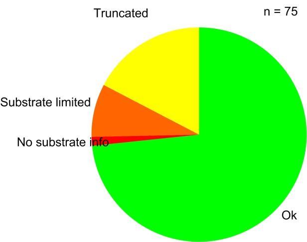
1 Appendix A. Depth limits of selected species Perennial macroalgae, stoneworts and higher plant taxa observed in more than 50 transects were selected for depth limit studies. Crustose algae, land plants, bryophytes, free floating taxa and helophytes were excluded. Each selected taxon was classified according to main substrate preference (hard, soft or ambiguous) to make it possible to exclude substrate limited observations of depth limits (Table 1). Some taxa where grouped before analysis in order to reduce taxonomic differences between time periods and different divers, e.g. Fucus radicans was recently separated from F. vesiculosus and is grouped as F. vesiculosus. All groupings are reported in Table 1. Table 1 Taxa selected for depth distribution studies. Substrate preference H = hard bottom species, S = soft bottom species and A = ambigous (species living on both hard and soft substrates). Taxa marked with X in the column MSMDI are included in the current Swedish assessment method. Taxon groupings are illustrated by the small number to the right of the taxon name; 1 includes F. radicans, 2 includes R. cirrhosa and R. marina, 3 includes Zannichellia, Z. palustris var. major, Z. palustris var. repens, 4 includes M. sibiricum, 5 includes Rhodomela, 6 includes Furcellaria and 7 includes Coccotylus truncatus and Phyllophora pseudoceranoïdes. Group Taxon Substrate preference Phaeophyceae Desmarestia aculeata H Phaeophyceae Ascophyllum nodosum H Phaeophyceae Fucus serratus H X Phaeophyceae Fucus vesiculosus 1 H X Phaeophyceae Halidrys siliquosa H X Phaeophyceae Sargassum muticum H Phaeophyceae Laminaria digitata H Phaeophyceae Laminaria hyperborea H Phaeophyceae Saccharina latissima H X Phaeophyceae Battersia arctica H X Phaeophyceae Chaetopteris plumosa H Chlorophyta Aegagropila linnaei A X Chlorophyta Cladophora rupestris H X Magnoliophyta Potamogeton gramineus S Magnoliophyta Potamogeton pectinatus S Magnoliophyta Potamogeton perfoliatus S X Magnoliophyta Ruppia 2 S Magnoliophyta Zannichellia palustris 3 S Magnoliophyta Zostera marina S X Magnoliophyta Eleocharis acicularis S Magnoliophyta Callitriche hermaphroditica S Magnoliophyta Ranunculus peltatus ssp. baudotii S Magnoliophyta Myriophyllum spicatum 4 S Rhodophyta Ahnfeltia plicata H Rhodophyta Ceramium virgatum H Rhodophyta Delesseria sanguinea H X Rhodophyta Membranoptera alata H Rhodophyta Phycodrys rubens H X Rhodophyta Odonthalia dentata H Rhodophyta Polysiphonia elongata H Rhodophyta Polysiphonia fucoides H Rhodophyta Polysiphonia stricta H Rhodophyta Rhodomela confervoides 5 H X MSMDI
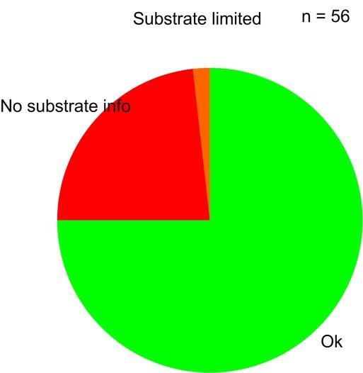
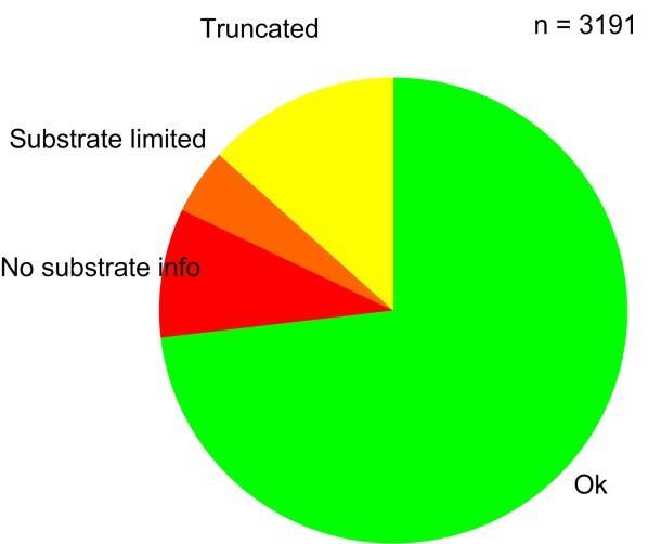
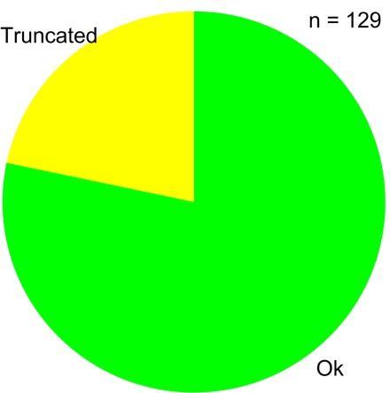
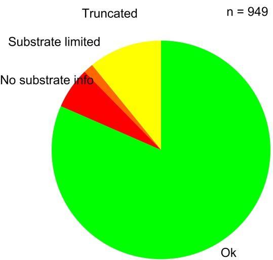
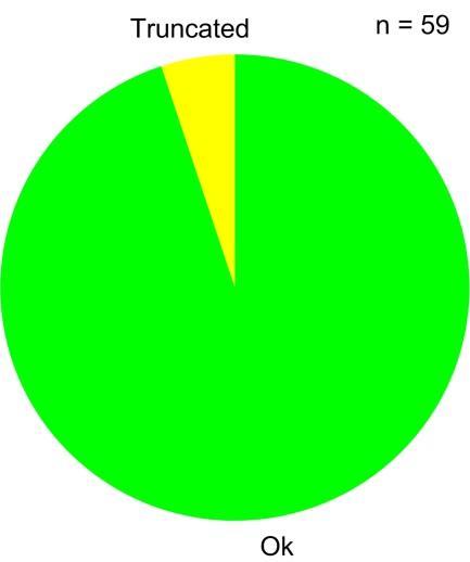
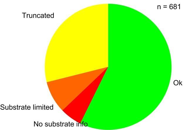
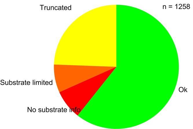
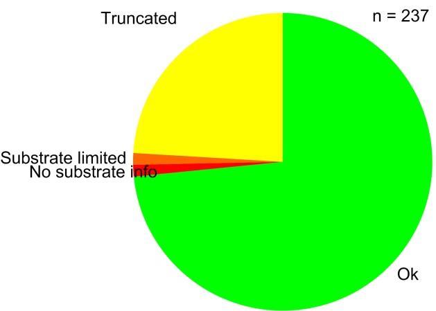
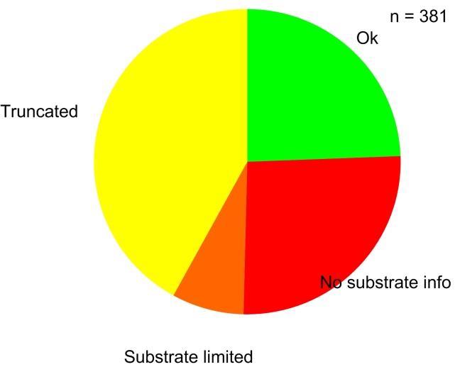
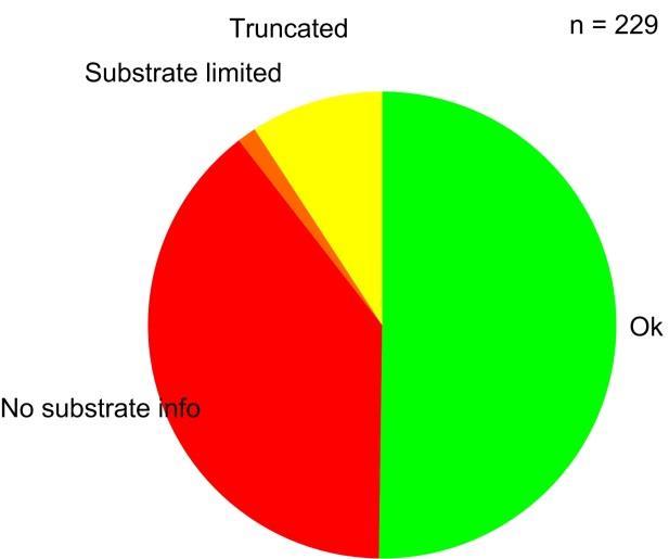
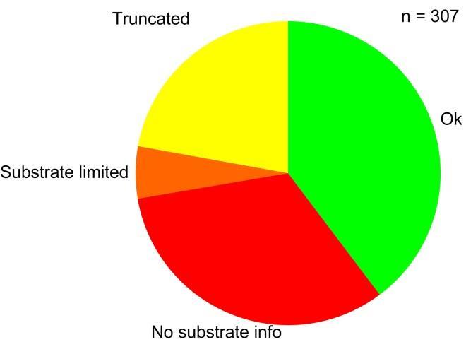
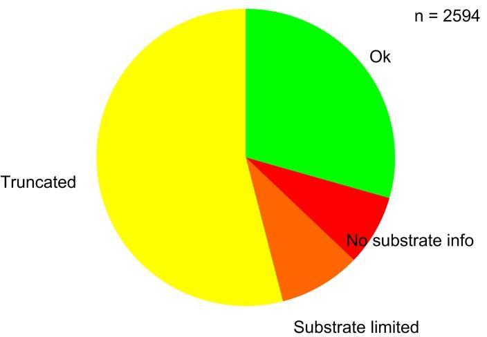
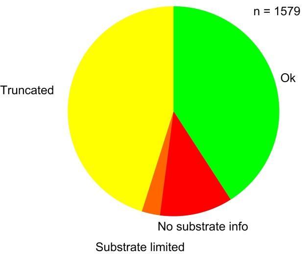
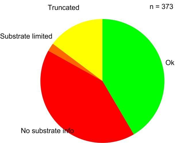
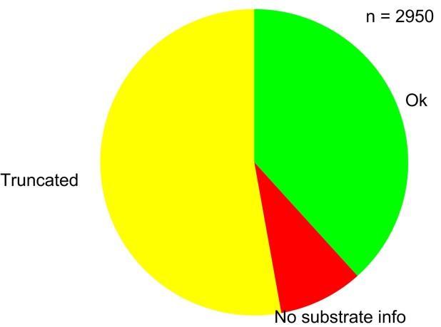
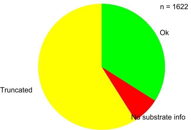
2 Group Taxon Substrate preference Rhodophyta Plumaria plumosa H Rhodophyta Corallina officinalis H Rhodophyta Cystoclonium purpureum H Rhodophyta Dilsea carnosa H Rhodophyta Furcellaria lumbricalis 6 A X Rhodophyta Chondrus crispus H X Rhodophyta Coccotylus/Phyllophora 7 A X Rhodophyta Polyides rotundus H Charophyceae Chara aspera S Charophyceae Chara baltica S X Charophyceae Chara globularis S MSMDI Before analysis depth limits that were truncated, were substrate limited or lacked substrate information were excluded. In Table 2 the total number of transects with depth limits for each selected species are shown together with the number of excluded depth limits due to the different reasons. Table 2 Number of depth limits (transects) for each taxon selected for plotting of depth limits. Total number of depth limits is shown together with the number of excluded depth limits due to different reasons. Column OK show the number of depth limits that are used in the plots. Columns East and West show the number of OK depth limits on each side of Sweden (excluding open sea). West represents data from national type 1-6 and 25 and east data from national typ Taxon No substrate info Substrate limited Truncated OK Total East West Desmarestia aculeata Ascophyllum nodosum Fucus serratus Fucus vesiculosus Halidrys siliquosa Sargassum muticum Laminaria digitata Laminaria hyperborea Saccharina latissima Battersia arctica Chaetopteris plumosa Aegagropila linnaei Cladophora rupestris Potamogeton gramineus Potamogeton pectinatus Potamogeton perfoliatus Ruppia Zannichellia palustris Zostera marina Eleocharis acicularis Callitriche hermaphroditica Ranunculus peltatus ssp baudotii Myriophyllum spicatum Ahnfeltia plicata
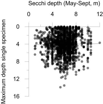
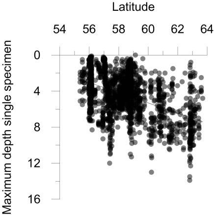
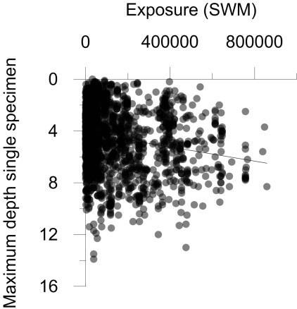
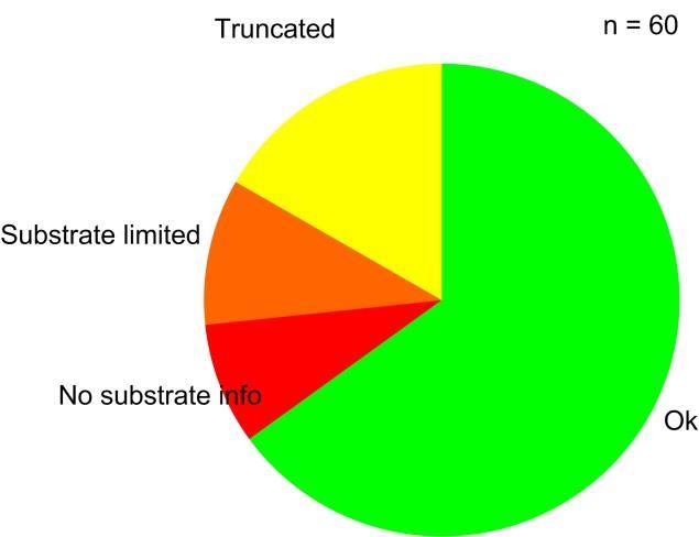
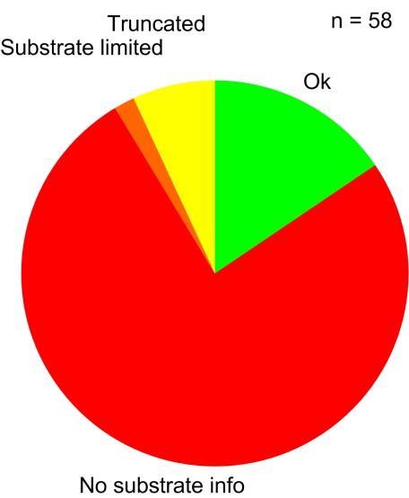
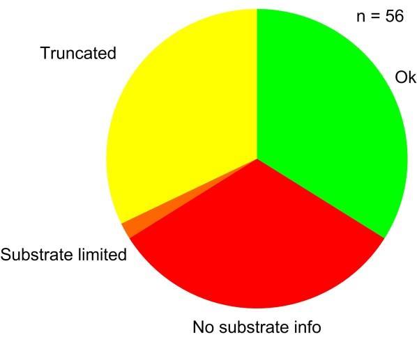
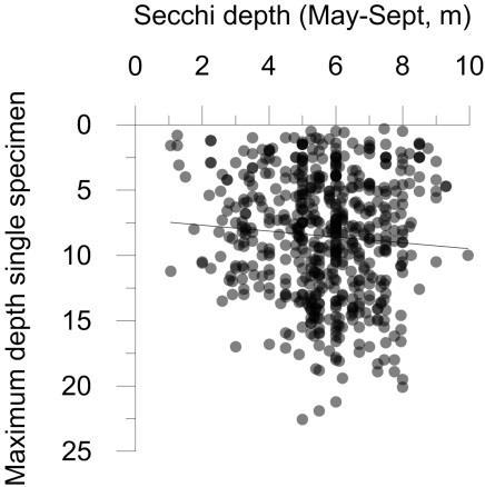
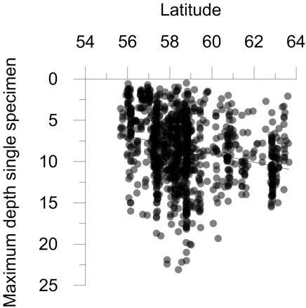
3 Taxon No substrate info Substrate limited Truncated OK Total East West Ceramium virgatum Delesseria sanguinea Membranoptera alata Phycodrys rubens Odonthalia dentata Polysiphonia elongata Polysiphonia fucoides Polysiphonia stricta Rhodomela confervoides Plumaria plumosa Corallina officinalis Cystoclonium purpureum Dilsea carnosa Furcellaria lumbricalis Chondrus crispus Coccotylus/Phyllophora Polyides rotundus Chara aspera Chara baltica Chara globularis Deeper living species like Battersia arctica, Delesseria sanguinea, Furcellaria lumbricalis and Polysiphonia fucoides have higher rates of truncated depth limits. Several of the west coast species depth limits lack associated substrate information making it impossible to assess substrate limitation, e.g Laminaria spp and Saccharina latissima. Substrate limitation is not common reason for exclusion with the methods we have used, highest rate is observed for the deep living Battersia arctica. Within this appendix there is one section with graphs for each selected species. The geographic distribution of the depth limits is shown on a map where yellow represents truncated depth limits, orange represents substrate limited depth limits, red represents depth limits without substrate information and green the remaining depth limits. Grey color represents sites where the species is found but no depth limits are measured, e.g. point occurrence data. The number of transects within each group is illustrated in a pie graph with the same color scheme as used in the map. Distribution of maximum depth limits of single specimens within each national type is shown in a box plot (national types are illustrated in Figure 1). In each box the number of depth limits within that national type is given. Only depth limits that have substrate information and not are substrate limited or truncated are included in the box plots and the following scatter plots. National type 0 represents open sea (offshore banks) all around the coast. Data from open sea is rare due to few sampling occasions and few areas shallow enough for vegetation. In the scatter plots depth limits are plotted against selected eutrophication factors, secchi depth, total nitrogen, total phosphorus, chlorophyll a and the selected natural gradients latitude, salinity and exposure. A linear regression line is given just to show the tendency in the relationships. Please note that not all depth limits have been possible to relate to all environmental data, i.e. in some cases nutrients, secchi, chl a or salinity is missing. All depth limits are related to latitude and exposure. If a species has a significant number of observations on both the west and east coast of Sweden separate scatterplots for only east and west coast data are also given.

4 Figure 1 Swedish national types according to NFS2006:1. Map from Leonardsson et al Coastline copyrighted by Lantmäteriet.
5 Desmarestia aculeata
6 Ascophyllum nodosum
7 Fucus serratus
8 Fucus serratus east coast (type 7-24)
9 Fucus serratus west coast (type 1-6 and 25)
10 Fucus vesiculosus
11 Fucus vesiculosus east coast (type 7-24)
12 Fucus vesiculosus west coast (type 1-6 and 25)
13 Halidrys siliquosa

14 Sargassum muticum

15 Laminaria digitata
16 Laminaria hyperborea
17 Saccharina latissima

18 Battersia arctica
19 Chaetopteris plumosa
20 Aegagropila linnaei
21 Cladophora rupestris
22 Cladophora rupestris east coast (type 7-24)
23 Cladophora rupestris west coast (type 1-6 and 25)
24 Potamogeton gramineus
25 Potamogeton pectinatus

26 Potamogeton perfoliatus
27 Ruppia
28 Zannichellia palustris

29 Zostera marina
30 Zostera marina east coast (type 7-24)
31 Zostera marina west coast (type 1-6 and 25)

32 Eleocharis acicularis
33 Callitriche hermaphroditica

34 Ranunculus peltatus ssp. baudotii
35 Myriophyllum spicatum

36 Ahnfeltia plicata

37 Ceramium virgatum
38 Ceramium virgatum east coast (type 7-24)
39 Ceramium virgatum west coast (type 1-6 and 25)
40 Delesseria sanguinea
41 Membranoptera alata

42 Phycodrys rubens
43 Odonthalia dentata
44 Polysiphonia elongata
45 Polysiphonia fucoides
46 Polysiphonia fucoides east coast (type 7-24)
47 Polysiphonia fucoides west coast (type 1-6 and 25)
48 Polysiphonia stricta
49 Rhodomela confervoides
50 Rhodomela confervoides east coast (type 7-24)
51 Rhodomela confervoides west coast (type 1-6 and 25)

52 Plumaria plumosa
53 Corallina officinalis
54 Cystoclonium purpureum
55 Dilsea carnosa
56 Furcellaria lumbricalis
57 Furcellaria lumbricalis east coast (type 7-24)
58 Furcellaria lumbricalis west coast (type 1-6 and 25)
59 Chondrus crispus
60 Coccotylus/Phyllophora
61 Coccotylus/Phyllophora east coast (type 7-24)
62 Coccotylus/Phyllophora west coast (type 1-6 and 25)

63 Polyides rotundus

64 Chara aspera

65 Chara baltica
66 Chara globularis
Justification for the Swedish method for BQE Macroalgae and angiosperms
 Justification for the Swedish method for BQE Macroalgae and angiosperms Mats Blomqvist, Hafok AB 2011 06 12 Introduction In the JRC document Method compliance checking: which methods can be included in
A SURVEY OF THE SEAWEEDS OF LENNOX PASSAGE AND ST. PETERS BAY, CAPE BRETON ISLAND, NOVA SCOTIA
 Proceedings of the Nova Scotian Institute of Science (2017) Volume 49, Part 1, pp. 61-96 A SURVEY OF THE SEAWEEDS OF LENNOX PASSAGE AND ST. PETERS BAY, CAPE BRETON ISLAND, NOVA SCOTIA HERB VANDERMEULEN*
Seagrass Beds of Borthwen Bay, Rhoscolyn, Anglesey 2012.
 Seagrass Beds of Borthwen Bay, Rhoscolyn, Anglesey 2012. A report by Vicki Greenhalgh and Liz Morris for Seasearch Seagrasses are flowering plants able to tolerate inundation or total submergence by the
Indicators for ecological status of angiosperms and charophytes in Danish coastal waters
 Indicators for ecological status of angiosperms and charophytes in Danish coastal waters Research note from DCE - Danish Centre for Environment and Energy Date: 7 March 2018 Jacob Carstensen & Dorte Krause-Jensen
Video or dive? Methods for integrated monitoring and mapping of marine habitats in the Hvaler-Koster area
 Video or dive? Methods for integrated monitoring and mapping of marine habitats in the Hvaler-Koster area A report from project Hav möter Land Klimat vatten samhällsplanering tillsammans Rapportnummer:
Bottom habitat mapping in Plateliai lake applying remote underwater video techniques
 Bottom habitat mapping in Plateliai lake applying remote underwater video techniques Darius Daunys 1,3 Šarūnas Navickas 2, Modesta Riaukaitė 1, Martynas Bučas 1,3, Aleksej Šaškov 3, Andrius Šiaulys 1,3
BIG MARINE LAKE, WASHINGTON COUNTY: 2017 AQUATIC VEGETATION REPORT
 BIG MARINE LAKE, WASHINGTON COUNTY: 2017 AQUATIC VEGETATION REPORT Report by the Invasive Species Program Division of Ecological and Water Resources Minnesota Department of Natural Resources Lake: Big
Chateaugay Lakes Milfoil Control Program
 Chateaugay Lakes Milfoil Control Program Summary of Activities and Findings for June August 29 Prepared By: Daniel L. Kelting Executive Director Adirondack Watershed Institute Paul Smith's College P.O.
Seasearch South Cardigan Bay Seahorse habitat surveys 2011
 Seasearch South Cardigan Bay Seahorse habitat surveys 2011 Seasearch was requested by the Wales Biodiversity Partnership and Anglesey Sea Zoo to assist with a preliminary feasibility study for the re-establishment
2015 Macrophyte Survey Results
 Invasive Macrophyte Survey Pilot 2015 2015 Macrophyte Survey Results COMPLETED WITH SUPPORT FROM: Acknowledgments The Invasive Plant Monitoring Program was made possible through the support of Alberta
Aquatic Plant Point-Intercept Survey for Pike Lake, Scott County, Minnesota
 Campers on Pike Lake, Scott County, Minnesota, 2015 Aquatic Plant Point-Intercept Survey for Pike Lake, Scott County, Minnesota [Plant Survey Conducted August 24, 2015] Prepared for: Prior Lake/Spring
The Shore Thing Survey Form
 The Shore Thing Survey Form Details School/college/ group Surveyors Teacher/leader The Survey Section 1 Section 2 A transect of three stations, Upper, Middle and Lower Shore. At each station sample four
QUALITATIVE COMPOSITION OF MACROPHYTE VEGETATION AND CYPRINID FAUNA FROM LAKE OHRID
 68 Bulgarian Journal of Agricultural Science, 21 (Supplement 1) 2015, 68 75 Agricultural Academy QUALITATIVE COMPOSITION OF MACROPHYTE VEGETATION AND CYPRINID FAUNA FROM LAKE OHRID M. TALEVSKA * and T.
P Simpevarp site investigation. Inventory of macrophyte communities at Simpevarp nuclear power plant
 P-03-69 Simpevarp site investigation Inventory of macrophyte communities at Simpevarp nuclear power plant Area of distribution and biomass determination Ronny Fredriksson, Stefan Tobiasson Kalmar University
Habitat preferences in spawning and juvenile cuttlefish
 Cephalopod recruitment from English Channel Spawning Habitats INTERREG IVA project CRESH Habitat preferences in spawning and juvenile cuttlefish Emma Jackson 1, & Isobel Bloor 1,2, 1 Marine Biological
GRASS CARP SPAWNING IN LAKE ERIE TRIBUTARIES: WHEN AND WHERE?
 GRASS CARP SPAWNING IN LAKE ERIE TRIBUTARIES: WHEN AND WHERE? Nicole R. King 1, Patrick M. Kocovsky 2, Christine M. Mayer, 1 Song S. Qian 1 1. University of Toledo Dept. Environmental Sciences and Lake
Department of Marine Resources Site Review #
 Department of Marine Resources Site Review #2017-11 Taunton Bay Oyster Company, Inc. P.O. Box 613 Ellsworth, ME 04605 207-266-3353 Figure 1: Vicinity map 1 Location: Taunton Bay, Town of Hancock, Hancock
Runswick Bay recommended MCZ Seasearch Site Surveys 2012
 Bay recommended MCZ Seasearch Site Surveys 2012 This report summarises the results of intertidal and subtidal surveys carried out in the recommended Marine Conservation Zone by Seasearch volunteers between
The Journal of Animal Ecology, Vol. 24, No. 2. (Nov., 1955), pp
, pp") The Ecological Distribution of British Species of Idotea (Isopoda) E. Naylor STOR The Journal of Animal Ecology, Vol. 4, No.. (Nov., 1955), pp. 55-69. Stable URL: http://links.jstor.org/sici?sici=001-8790%8195511%94%3a%3c55%3atedobs%3e.0.co%3b-%3
The Ecological Distribution of British Species of Idotea (Isopoda) E. Naylor STOR The Journal of Animal Ecology, Vol. 4, No.. (Nov., 1955), pp. 55-69. Stable URL: http://links.jstor.org/sici?sici=001-8790%8195511%94%3a%3c55%3atedobs%3e.0.co%3b-%3
Aquatic Vegetation of Bass Lake
 Aquatic Vegetation of Bass Lake July, August and September, 2012 Bulrush, wild rice and waterlilies in channel between the North and South basins of Bass Lake, 2012. Bass Lake, ID# 31-0576-00 Itasca County,
2015 Starry Stonewort Inspection and Assessment Report: Lake Koronis, Stearns County MNDNR Division of Ecological and Water Resources
 Lake: Koronis (DOW#73020000) County: Stearns Report type: Starry stonewort Inspection and Assessment MNDNR Field Contributors: Christine Jurek (Invasive Species Specialist), Courtney Millaway (Natural
Conservation proposals for ecologically important areas in the Baltic Sea. Baltic
 Conservation proposals for ecologically important areas in the Baltic Sea Baltic Conservation proposals for ecologically important areas in the Baltic Sea Baltic 1. Introduction 04 2. Characteristics
Department of Marine Resources Site Review #
 Department of Marine Resources Site Review #2015-15 The Maine Mariculture Company 32 Merchant s Landing Spruce Head, ME 04859 203-650-3458 Figure 1*: Vicinity map Location: Pleasant Island (Unorganized
Aquatic Plant Point-Intercept Survey for Cates Lake, Scott County, Minnesota
 American Lotus in Cates Lake, Scott County, Minnesota, 2016 Aquatic Plant Point-Intercept Survey for Cates Lake, Scott County, Minnesota [Plant Survey Conducted August 29, 2016] Prepared for: Prior Lake-Spring
Rostock. Meeresbiolog. Beitr. Heft Rostock 2009
 Rostock. Meeresbiolog. Beitr. Heft 22 7-42 Rostock 2009 Tim STEINHARDT *, Rolf KAREZ, Uwe SELIG & Hendrik SCHUBERT *Dr. Tim Steinhardt, Universität Rostock, Lehrstuhl Ökologie, Institut für Biowissenschaften,
The Impact of Tide Pool Size on Species Richness and Diversity on Hurricane Island, Maine. Elsa Nierenberg and Yulin Holder
 The Impact of Tide Pool Size on Species Richness and Diversity on Hurricane Island, Maine Elsa Nierenberg and Yulin Holder Chapter 2 May 17-25th, 2017 The Impact of Tide Pool Size on Species Richness and
Comparison of Fish Communities at Two Danish Coastal Boulder reefs studied through Snorkel Visual Census, Stomach Analyse and Stable Isotopes
 Master thesis: Comparison of Fish Communities at Two Danish Coastal Boulder reefs studied through Snorkel Visual Census, Stomach Analyse and Stable Isotopes By Simone Lorange Jensen 201206193 Department
Flora of Plymouth Sound and Adjacent Waters. Preliminary Paper.
 286 FLORA OF PLYl\lOU'rH SOUND Flora of Plymouth Sound and Adjacent Waters. Preliminary Paper. By T..Johnson, B.Sc., Professor of Botany in the Royal College of Science, Dublin. A GOVERNMENT grant by the
Eurasian water-milfoil (Myriophyllum spicatum) SCUBA Dive Monitoring Survey Sand Bar Lake WBIC: Bayfield County, Wisconsin
 SCUBA Dive Monitoring Survey Sand Bar Lake WBIC: Bayfield County, Wisconsin") Eurasian water-milfoil (Myriophyllum spicatum) SCUBA Dive Monitoring Survey Sand Bar Lake WBIC: 2494900 Bayfield County, Wisconsin 6ft EWM Towers with Rooted Branch Preparing to Fall Off (Berg 2016) EWM
Eurasian water-milfoil (Myriophyllum spicatum) SCUBA Dive Monitoring Survey Sand Bar Lake WBIC: 2494900 Bayfield County, Wisconsin 6ft EWM Towers with Rooted Branch Preparing to Fall Off (Berg 2016) EWM
MaxDepth Aquatics, Inc.
 MaxDepth Aquatics, Inc. Hydroacoustic Survey and Point Sampling of Macrophytes In Diamond Lake 2009 A Report to the Partners for Umpqua Rivers Roseburg, OR And the Umpqua National Forest Roseburg, OR By
Oceana proposal for a Marine Protected Area
 2013 11 BALTIC SEA PROJECT Oceana proposal for a Marine Protected Area Introduction Denmark s is located between Jutland and Fyn. The and the Great Belt together form the Belt Sea, which is a transition
SAV. Pocket Field Guide. Watchers. SAV species list. Hornwort. Tier 1 monitoring parameters. Ceratophyllum demersum
 Chesapeake Bay SAV Watchers Pocket Field Guide 2 SAV species list Cd - Hornwort - Ceratophyllum demersum Cal - Water starwort - Callitriche sp. Egd - Brazilian waterweed - Egeria densa Ex - Unknown waterweed
Starry Stonewort. A new aquatic invader in Wisconsin. Michelle Nault Wisconsin Department of Natural Resources
 Starry Stonewort A new aquatic invader in Wisconsin Michelle Nault Wisconsin Department of Natural Resources Michelle.Nault@Wisconsin.gov Photo: Paul Skawinski What is starry stonewort? Starry stonewort
Mud Bay SLELO-PRISM Water Chestnut & Hydrilla Surveillance 2012
 St. Lawrence Eastern Lake Ontario Partnership for Regional Invasive Species Management Mud Bay Water Chestnut & Hydrilla Surveillance 2012 June 27 th (Water Chestnut) & August 2 (Hydrilla), 2012 Figure
BIODIVERSITY OF MACROPHYTE VEGETATION FROM LAKE PRESPA, LAKE OHRID AND LAKE SKADAR
 BIODIVERSITY OF MACROPHYTE VEGETATION FROM LAKE PRESPA, LAKE OHRID AND LAKE SKADAR M. Talevska 1, D. Petrovic 2, D. Milosevic 2, T. Talevski 1, D. Maric 2 and A. Talevska 3 1 Hidrobiological Institute
JICA Niger 523 rue des lacs PL521 Quartier Plateau Commune 1 Niamey Niger
 Biosphere Sci. 49 31 38 (2010) 1,5 2 3 1 4 5 1 739-0452 2-17-5 2 JICA Niger 523 rue des lacs PL521 Quartier Plateau Commune 1 Niamey Niger 3 781-1164194 4 811-01143-9-4 5 739-8528 1-4-4 38 64 1005m red
COASTAL UPWELLING - MONTEREY BAY CALIFORNIA (modified from The Maury Project, AMS)
") Name: Date: Per: COASTAL UPWELLING - MONTEREY BAY CALIFORNIA (modified from The Maury Project, AMS) The ocean is composed of 3 distinct layers: the shallow surface mixed zone, the transition zone, and
Name: Date: Per: COASTAL UPWELLING - MONTEREY BAY CALIFORNIA (modified from The Maury Project, AMS) The ocean is composed of 3 distinct layers: the shallow surface mixed zone, the transition zone, and
Newquay Area & Newquay and the Gannel recommended Marine Conservation Zone. Seasearch Dives 2014
 Newquay Area & Newquay and the Gannel recommended Marine Conservation Zone Seasearch Dives 20 Newquay & the Gannel was put forward as a recommended Marine Conservation Zone by the Finding Sanctuary Regional
ASSESSMENT OF INFORMATION ON IRISH MOSS, ROCKWEED AND KELP HARVESTS IN NOVA SCOTIA
 Canadian Science Advisory Secretariat Science Advisory Report 2013/004 ASSESSMENT OF INFORMATION ON IRISH MOSS, ROCKWEED AND KELP HARVESTS IN NOVA SCOTIA Figure 1. Nova Scotia Marine Plant Harvesting Districts
Species. Totals by region: Bivalves (counted as habitat). Species with no marine or estuarine life stage.
. Species with no marine or estuarine life stage.") Habitats Shellfish aggregations: Oyster reef. Hard clam beds. Scallop beds. Dead shell accumulations. Other sessile fauna: Primary coral reef architecture. Patch reef, soft coral, anemones amidst soft
Habitats Shellfish aggregations: Oyster reef. Hard clam beds. Scallop beds. Dead shell accumulations. Other sessile fauna: Primary coral reef architecture. Patch reef, soft coral, anemones amidst soft
Aquatic Plants of the Three Lakes
 Aquatic Plants of the Three Lakes Chris Doyle, CLM Senior Aquatic Biologist/Water Quality Program Supervisor Allied Biological, Inc. 580 Rockport Road Hackettstown, NJ 07840 Phone: 908-850-0303 E-mail:
HELSINKI COMMISSION HELCOM RED LIST BIOTOPES 10/2013 RED LIST Biotope Expert Team Tenth Meeting Helsinki, Finland, April 2013
 HELSINKI COMMISSION HELCOM RED LIST BIOTOPES 10/2013 RED LIST Biotope Expert Team Tenth Meeting Helsinki, Finland, 24-25 April 2013 Agenda Item 3 Finalisation of the Classification of Biotopes Document
SAV. Watchers. Pocket Field Guide
 Chesapeake Bay SAV Watchers Pocket Field Guide Field packing list Tier 1 On-site reporting Smartphone equipped with the Water Reporter app SAV species guide Off-site reporting Paper Pencil Watch or Clock
OBSERVING CORALS and ALGAE:
 5 OBSERVING CORALS and ALGAE: MANTA TOW, SNORKEL SURVEY, and POINT-INTERCEPT TRANSECT A. Manta Tow Definition A manta tow survey is the observation of an underwater area of good visibility by a snorkeler
LanguaL proposal from FR-ANSES 2016
 2017-07-17 LanguaL proposal from FR-ANSES 2016 LanguaL proposals based on FR-ANSES 2016 database. ARGAN SAITHE [B1440] GOOSEFISH [B2405] LUPINE BEAN [B1701] PHYTOSTER OL CLAIM OR USE DUSKY SEA PERCH [B4020]
Management of Hybrid Watermilfoil (Myriophyllum sibericum x spicatum) using Diver Assisted Suction Harvesting
 using Diver Assisted Suction Harvesting") 2527 Lake Ottawa Road Iron River, MI 49935 906.284.2198 Management of Hybrid Watermilfoil (Myriophyllum sibericum x spicatum) using Diver Assisted Suction Harvesting Lake Ellwood, Florence, WI - 2014 Final
2527 Lake Ottawa Road Iron River, MI 49935 906.284.2198 Management of Hybrid Watermilfoil (Myriophyllum sibericum x spicatum) using Diver Assisted Suction Harvesting Lake Ellwood, Florence, WI - 2014 Final
Little Belt. Oceana proposal for a Marine Protected Area. Introduction
 2014 11 BALTIC SEA PROJECT Oceana proposal for a Marine Protected Area Introduction Denmark s is a marine strait located between the Jutland mainland and the island of Fyn. The Little Belt and the Great
Substrate Preference between two Caprellid species: Caprella mutica and Caprella drepanochir
 Substrate Preference between two Caprellid species: Caprella mutica and Caprella drepanochir By: Jennifer Maciejeski Oregon Institute ofmarine Biology-Charleston, OR Summer 2008 Introduction Caprellids
Nearshore Habitat Mapping in Puget Sound Using Side Scan Sonar and Underwater Video
 Nearshore Habitat Mapping in Puget Sound Using Side Scan Sonar and Underwater Video Dana Woodruff, Paul Farley, Amy Borde, John Southard, Ron Thom Battelle Marine Sciences Laboratory Jim Norris Marine
A brief introduction to rocky shores and their biota
 A brief introduction to rocky shores and their biota Prepared by Jennifer Coughlan and Tasman Crowe School of Biology and Environmental Science, University College Dublin A rocky shore is an intertidal
REQUEST FOR BID FOR DIVER ASSISTED SUCTION HARVESTING
 REQUEST FOR BID FOR DIVER ASSISTED SUCTION HARVESTING Located on Black Otter Lake, Village of Hortonville, Outagamie County Issued on: January 18, 2018 Due Date: March 16, 2018, 12:00PM Administered by:
Lake LeAnn 2018 Fish Survey
 Lake LeAnn 2018 Fish Survey June 21, 2018 Prepared for: Lake LeAnn Property Owners Association Prepared by: ADVANCED ECOLOGICAL MANAGEMENT 22071 7 Mile Road Reed City, MI 49677 Table of Contents 1.0 INTRODUCTION...
Seasearch survey of Drake s Island eelgrass Summary Report 19 June 2012
 Seasearch survey of Drake s Island eelgrass Summary eport 19 June 2012 n 19 th June a group of 10 volunteer divers undertook an evening survey dive on the Zostera marina bed to the north of Drake s Island
Luce Bay and Sands Special Area of Conservation
 Luce Bay and Sands Special Area of Conservation Advice under Regulation 33(2) of The Conservation (Natural Habitats, &c.) Regulations 1994 (as amended) 30 March 2006 About this Package: Section 1 of this
SUBCHAPTER 03I GENERAL RULES SECTION.0100 GENERAL RULES
 SUBCHAPTER 03I GENERAL RULES SECTION.0100 GENERAL RULES 15A NCAC 03I.0101 DEFINITIONS All definitions set out in G.S. 113, Subchapter IV and the following additional terms apply to this Chapter: (1) Enforcement
Ray D. Valley* and Melissa T. Drake. Minnesota Department of Natural Resources Division of Fisheries and Wildlife 1200 Warner Road St.
 Minnesota Department of Natural Resources Investigational Report 527, December 2005 ACCURACY AND PRECISION OF HYDROACOUSTIC ESTIMATES OF AQUATIC VEGETATION AND THE REPEATABILITY OF WHOLE-LAKE SURVEYS:
Sea urchin density along a depth gradient at Rodney's Rock and Champagne Bay, Dominica
 Sea urchin density along a depth gradient at Rodney's Rock and Champagne Bay, Dominica Michele Felix Cassie Kalinec Julia Lemmon Carl Raetzsch A.J. Vale Andrew Woolley May 28 June 17, 2004 1 Abstract The
MINISTRY OF THE ENVIRONMENT. Aquatic Plant Growths in Lake Couchiching
 MINISTRY OF THE ENVIRONMENT Aquatic Plant Growths in Lake Couchiching 1972 Copyright Provisions and Restrictions on Copying: This Ontario Ministry of the Environment work is protected by Crown copyright
From Phosphorus to Fish: Beneficial Use of Excess Nutrients
 FLOATINGISLANDINTERNATIONAL From Phosphorus to Fish: Beneficial Use of Excess Nutrients Project Location: Shepherd, Montana Fishing can be the primary method for transitioning excess nonpoint source nutrients
DRAFT AMENDMENT 1. Introduction
 DRAFT AMENDMENT 1 Aquatic Plant Management Plan, Yahara River and Upper Mud Lake, Lower Rock River Basin, Dane County Wisconsin Approved by the Dane County Lakes and Watershed Commission on and by the
Table 1. Physical Characteristics of Your Lake.
 The lake assessments are created in partnership with Hillsborough County and the Florida Center for Community Design and Research LAKE ASSESSMENT DOCUMENT White Trout Lake /8/98 Watershed: Sweetwater Creek
Aquatic Invasive Plant Surveys in the BLM Medford District During 2012
 Portland State University PDXScholar Center for Lakes and Reservoirs Publications and Presentations Center for Lakes and Reservoirs 4-2013 Aquatic Invasive Plant Surveys in the During 2012 Rich Miller
Inchmarnock Island Survey Report September Owen Paisley Seasearch West Co-ordinator
 Inchmarnock Island Survey eport September 2013 wen Paisley Seasearch West Co-ordinator Sites 3 and 4 2007 Survey Sites1 and 2 The Inchmarnock Maerl Bed Chart 1 Location of Inchmarnock Dive Sites Inchmarnock
LOWER ST. JOHNS RIVER REPORT APPENDICES BACKGROUND APPENDIX 1.A.
 LOWER ST. JOHNS RIVER REPORT APPENDICES BACKGROUND APPENDIX 1.A. TOTAL AREAS OF WETLAND AND DEEPWATER HABITATS St. Johns River Water Management District Wetland and Deep Water Habitat Maps (based on aerial
Eurasian Water-milfoil Bed Mapping Survey Red Lake (WBIC: ) Douglas County, Wisconsin
 Douglas County, Wisconsin") Eurasian Water-milfoil Bed Mapping Survey Red Lake (WBIC: 2492100) Douglas County, Wisconsin Red Lake Eurasian water-milfoil with >12 leaflet pairs/limp whorls out of water EWM Beds on Red Lake 10/2/16
Eurasian Water-milfoil Bed Mapping Survey Red Lake (WBIC: 2492100) Douglas County, Wisconsin Red Lake Eurasian water-milfoil with >12 leaflet pairs/limp whorls out of water EWM Beds on Red Lake 10/2/16
Marstrand and Northeastern Kattegat
 2014 9 BALTIC SEA PROJECT Oceana proposal for a Marine Protected Area Introduction Marstrand, located in the southern Bohuslän Archipelago, is situated in the northeastern part of the Kattegat, on Sweden
Upwelling and Phytoplankton Productivity
 Name: Date: Guiding Questions: Upwelling and Phytoplankton Productivity How does nutrient concentration influence phytoplankton growth in coastal and open ocean waters? What and where are the upwelling
St Kilda Special Area of Conservation. Advice under Regulation 33(2) of The Conservation (Natural Habitats, &c.) Regulations 1994 (as amended)
 of The Conservation (Natural Habitats, &c.) Regulations 1994 (as amended)") St Kilda Special Area of Conservation Advice under Regulation 33(2) of The Conservation (Natural Habitats, &c.) Regulations 1994 (as amended) 30 March 2006 About this Package: Section 1 of this document
St Kilda Special Area of Conservation Advice under Regulation 33(2) of The Conservation (Natural Habitats, &c.) Regulations 1994 (as amended) 30 March 2006 About this Package: Section 1 of this document
Hampshire & Isle of Wight. Seasearch Summary Report Report prepared by Amy Dale. Hampshire & Isle of Wight. Wildlife Trust
 Hampshire & Isle of Wight Seasearch Summary Report 2011 Black bream eggs. Jolyon Chesworth. Cuttlefish eggs on eelgrass. Justin Evans. Edible crab. Charlotte Bolton. Common hermit crab. Justin Evans. Brill.
BIOTOPE INFORMATION SHEET
 English name: Sandbanks which are slightly covered by sea water all the time Characteristic species: Past and Current Threats (Habitat directive article 17): Fishing (Fishing and harvesting aquatic resources
PRINCE EDWARD ISLAND ESTUARINE WATER QUALITY MONITORING PROGRAM. January, 1999
 PRINCE EDWARD ISLAND ESUARINE WAER QUALIY MONIORING PROGRAM January, 1999 Kendall R. Shaw PEI Department of echnology and Environment Charlottetown, PEI Executive Summary wenty estuaries on Prince Edward
NOTES ON THE PLYMOUTH MARINE FLORA
 257 NOTES ON THE PLYMOUTH MARINE FLORA ALGAL RECORDS FOR THE PLYMOUTH REGION By Mary Parke The greater number of the species given in this list are new records for the Plymouth region. Recent records for
Aquatic Plant Surveys in Donner Lake State Park, California: Report to California State Parks. Final Draft
 Aquatic Plant Surveys in Donner Lake State Park, California: 2017 Report to California State Parks Final Draft Brant Allen, Katie Senft, and Brandon Berry UC Davis Tahoe Environmental Research Center February
Osoyoos Lake Aquatic Plant Mapping
 Osoyoos Lake Aquatic Plant Mapping AquaTechnex, LLC Presented to Okanogan County NWCB by PO Box 30824 Bellingham WA, 98228 www.aquatechnex.com Introductions Myriophyllum spicatum or Eurasian Milfoil has
PROCEDURE FOR MONITORING AN AQUATIC PLANT PROBLEM 1
 PROCEDURE FOR MONITORING AN AQUATIC PLANT PROBLEM 1 The density, diversity, and growth patterns of aquatic plants are unique to each lake. Therefore, many of the details concerning sample site locations
trriwww,.:( 1,1 K.1 -
 t- ISSN 0704-3716 CANADIAN TRANSLATION OF FISHERIES AND AQUATIC SCIENCES N o. 4712 Reduction of algal vegetation in Helgeland coastal waters by K. Sivertsen and A. Bjorge FIMIERIES ez OCEANS CANADA PECIIES
Predictive distribution modelling of cold-water corals in the Newfoundland and Labrador region
 The following supplement accompanies the article Predictive distribution modelling of cold-water corals in the Newfoundland and Labrador region Lauren Gullage*, Rodolphe Devillers, Evan Edinger *Corresponding
Context Most US West Coast open coast estuaries have: INTERTIDAL AQUACULTURE AS HABITAT IN PACIFIC NORTHWEST COASTAL ESTUARIES: CONSIDERING SCALE
 INTERTIDAL AQUACULTURE AS HABITAT IN PACIFIC NORTHWEST COASTAL ESTUARIES: CONSIDERING SCALE Brett Dumbauld USDA Agricultural Research Service Context Most US West Coast open coast estuaries have: Broad
Midterm #1. Part 1 (short answer) worth 2-4 points each (20 % of grade)
 worth 2-4 points each (20 % of grade)") Biology 221 - Fall 2011 Exam number KEY Part 1 (short answer) worth 2-4 points each (20 % of grade) 1 (4 pts) a) What are the tides called when the moon, sun and earth are aligned as depicted below? A)
Biology 221 - Fall 2011 Exam number KEY Part 1 (short answer) worth 2-4 points each (20 % of grade) 1 (4 pts) a) What are the tides called when the moon, sun and earth are aligned as depicted below? A)
TEACHER VERSION: Suggested Student Responses Included. Upwelling and Phytoplankton Productivity
 Name: Date: TEACHER VERSION: Suggested Student Responses Included Guiding Questions: Upwelling and Phytoplankton Productivity How does nutrient concentration influence phytoplankton growth in coastal and
FULL PAPERS. A 150-year old seaweed collection returns to Cumbrae. P. G. Moore. The Glasgow Naturalist (2008) Volume 25, Part 1, 3-8
 Volume 25, Part 1, 3-8") The Glasgow Naturalist (2008) Volume 25, Part 1, 3-8 FULL PAPERS A 150-year old seaweed collection returns to Cumbrae P. G. Moore University Marine Biological Station Millport, Isle of Cumbrae, Scotland,
The Glasgow Naturalist (2008) Volume 25, Part 1, 3-8 FULL PAPERS A 150-year old seaweed collection returns to Cumbrae P. G. Moore University Marine Biological Station Millport, Isle of Cumbrae, Scotland,
Glen Echo Lake Weed Biomass Study
 Weed Biomass Study Charlton, Massachusetts PREPARED FOR: Glen Echo Improvement Association PO Box 578 01508 PREPARED BY: ESS Group, Inc. 100 Fifth Avenue, 5th Floor Waltham, Massachusetts 02451 ESS Project
Kerr Lake Vegetation Survey. October November Report submitted by NC State University. Background
 Kerr Lake Vegetation Survey October November 2012 Report submitted by NC State University Background Hydrilla (Hydrilla verticillata) is a non-native invasive submersed aquatic plant. This plant was first
Seagrass surveys must be conducted between the dates of April 1 st and October 31 st with the following exceptions:
 Florida Fish and Wildlife Conservation Commission (FWC) Recommended Survey Protocols for Estuarine and Marine Submerged Aquatic Vegetation (SAV) related to Permitting Applications 12/14/2011 DRAFT 1) Survey
Taranaki Tsunami Inundation Analysis. Prepared for Taranaki Civil Defence Emergency Management Group. Final Version
 Taranaki Tsunami Inundation Analysis Prepared for Taranaki Civil Defence Emergency Management Group Final Version June 2012 AM 12/07 HBRC Plan Number 4362 Asset Management Group Technical Report Prepared
Available from Deakin Research Online:
 This is the published version: Hirst, Alistair, Heislers, Simon, Ball, David, Blake, Sean and Coots, Allister 2011, Baywide seagrass monitoring program : milestone report no. 11 (Oct. Nov. 2010) Department
Starry Stonewort in Silver Lake Washington County, WI BRAD STECKART AIS COORDINATOR FOR WASHINGTON AND WAUKESHA COUNTIES
 Starry Stonewort in Silver Lake Washington County, WI BRAD STECKART AIS COORDINATOR FOR WASHINGTON AND WAUKESHA COUNTIES Brad Steckart -AIS coordinator for Washington and Waukesha Counties -Graduated from
Component biotopes / species (biotope / common name)
") Priority Marine Features in Scotland s seas Table 1 Seabed habitats Priority Marine Feature Blue mussel beds Mytilus edulis beds on littoral sediments LS.LBR.LMus.Myt Mytilus edulis and Fabricia sabella
Priority Marine Features in Scotland s seas Table 1 Seabed habitats Priority Marine Feature Blue mussel beds Mytilus edulis beds on littoral sediments LS.LBR.LMus.Myt Mytilus edulis and Fabricia sabella
Rainbow River Environmental Study. Dunnellon, Florida
 Rainbow River Environmental Study Dunnellon, Florida Final Report September 2012 (Revised) Charles E. Cichra, PhD Program in Fisheries and Aquatic Sciences School of Forest Resources and Conservation Institute
Lesson 14: Modeling Relationships with a Line
 Exploratory Activity: Line of Best Fit Revisited 1. Use the link http://illuminations.nctm.org/activity.aspx?id=4186 to explore how the line of best fit changes depending on your data set. A. Enter any
What s UP in the. Pacific Ocean? Learning Objectives
 What s UP in the Learning Objectives Pacific Ocean? In this module, you will follow a bluefin tuna on a spectacular migratory journey up and down the West Coast of North America and back and forth across
Well, Well, Well. BACKGROUND Seasonal upwelling is a very important process in the coastal ocean of the Pacific Northwest.
 Well, Well, Well SUMMARY In this activity students investigate the relationship between winds, surface currents, sea surface temperature and upwelling and downwelling off the coast of OR and WA. Students
27Quantify Predictability U10L9. April 13, 2015
 1 QUANTIFYING PREDICTABILITY Exercise #1: Make sure that your calculator has its r value on. 2 Exercise #2: In the following exercises four data sets with equal x values are given to illustrate different
Dexter Marsh Wildlife Management Area and Muskellunge Creek: Water Hyacinth (Eichhornia crassipes) Assessment
 Assessment") St. Lawrence Eastern Lake Ontario Partnership for Regional Invasive Species Management Special Note The partners of the SLELO PRISM have identified 2 Priority Conservation Areas on which we conduct early
St. Lawrence Eastern Lake Ontario Partnership for Regional Invasive Species Management Special Note The partners of the SLELO PRISM have identified 2 Priority Conservation Areas on which we conduct early
Distribution and Abundance of Submerged Aquatic Vegetation in the Chesapeake Bay: A Scientific Summary
 College of William and Mary W&M ScholarWorks Reports 1-1-1982 Distribution and Abundance of Submerged Aquatic Vegetation in the Chesapeake Bay: A Scientific Summary Robert J. Orth Virginia Institute of
Monitoring Cruise Report
 r/v Gunnar Thorson Monitoring Cruise Report Cruise no.: 211 Time: 14-18 October 22 Area: The Sound, the Kattegat, the Belt Sea and the Arkona Sea Ministry of the Environment National Environmental Research
Historical and current observations on macroalgae in the Hillsborough Bay Estuary
 University of South Florida Scholar Commons Reports Tampa Bay Area Study Group Project 1-1-2002 Historical and current observations on macroalgae in the Hillsborough Bay Estuary J.O.R. Johansson Bay Study
Seagrass Surveys in Kampot
 Coastal Annual Forum 23 rd October 2014 Sihanoukville, Cambodia Seagrass Surveys in Kampot Presentation by Louis Bourne INTERNATIONAL UNION FOR CONSERVATION OF NATURE Presentation Overview Location and
Lake Havasu Aquatic Plant Monitoring 2011 Interim Report
 Lake Havasu Aquatic Plant Monitoring 2011 Interim Report An Interim Report Submitted to RNT Consulting and the Central Arizona Project John D. Madsen, Ryan M. Wersal, Amanda Fernandez and Gray Turnage
Eelgrass and Macroalgae Presence/Absence Preliminary Surveys BHP Proposed Grays Harbor Potash Export Facility A Task 400
 Memorandum 40600-HS-MEM-55036 Revision 0 Date: 26 July 2018 Subject: Eelgrass and Macroalgae Presence/Absence Preliminary Surveys BHP Proposed Grays Harbor Potash Export Facility A17.0202.00 Task 400 INTRODUCTION