Benefits of Proper Route Engineering to Mitigate Risk During the Design Life of Submarine Cable Systems
|
|
|
- Willa Smith
- 6 years ago
- Views:
Transcription


1 Benefits of Proper Route Engineering to Mitigate Risk During the Design Life of Submarine Cable Systems Simon Cooper TATA Communications International Gordon Lucas Alcatel-Lucent Submarine Networks Ron Rapp TE SubCom Graham Evans EGS Survey Group
2 Agenda Critical Infrastructure Consequence of Cable Outage Real Cost of Ownership Route Planning Tools and Risk Identification Physical and Political Routing Constraints Marine Route Survey Cable Protection and Installation Maintenance Considerations
3 Concept to Reality Key Phases Development of Business Model Definition of Key Project Milestones Project Concept & Initial Investors Feasibility Study & Initial Engineering Define Permitting Requirements Formation of Interim Management Team Pre Survey Desk Study Secure System Permits in Principle Supply Contract Processes Route Survey & Burial Assessment Marine Operations Permitting Route Survey Contract Process System Installation
4 Topics for A Submarine Cable Planning Discussion
5 Why are Submarine Cables important? International Commerce Freedom of Communication Information Sharing Lowest Cost Solution Sustainable and Footprint Lite
6 What do you want from your route? (Oh, and what don t you want?) Diversity versus Latency Market Coverage versus Permitting Complexity Risk & USP s versus Known & Me Too Big Enough versus Biggest Ever New Technology versus The Proven Local Factors versus Network Integration

7 The TGN Intra-Asia System TGN-Pacific (Japan Guam) is an existing system Singapore Vietnam Hong Kong Philippines Japan

8 TGN-IA s Resilient Architecture

9 Early Life Information

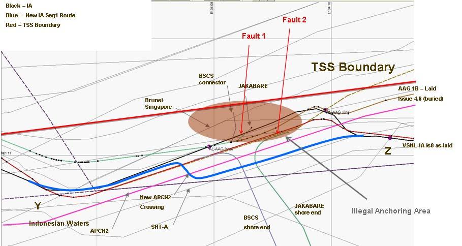
10 TGN-Intra Asia: The Re-Route
11 Total Cost of Ownership TCO translates to: What will you have to spend and when? A high quality Desk Top Survey High value $$ If it drives the survey PoW and Rt Eng pre-planning The Survey Who represents you? What are the goals and acceptable compromises? How to reduce the TCO? Cable Armour that may reduce repair volume: obvious value? Deep burial: can you afford not to? Deep water: who cares? Project Costs: Plan, Predict and Keep Under Control Future Costs: Replacement, Marine Ops, Reputation & Revenue
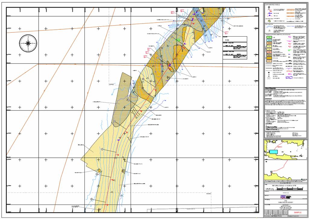
12 Route Planning Tools Use of a GIS based system is essential and facilitates the display of key information Existing in service and out of service cables Planned systems system deconfliction! Maritime boundaries, navigation charts and coastal data Sea bed assets associated with offshore energy Concession blocks Restricted areas such as marine parks, areas of SSI General seabed bathymetry and other survey data sets Marine Route Survey results
13 Risk Identification A thorough Cable Route Study (DTS) is crucial A comprehensive study of all potential threats: Fishing, anchoring, mineral extraction, slopes, seismic etc Fault histories of nearby cables and their status Landing point selection Influenced by risk and not by infrastructure or real estate Typical issues include crossing reefs in the surf zone, proximity to charted anchorages, high energy beaches Route Diversity from potential restoration cables Avoid areas of known seismic activity (fault histories) Political risk: permit lead times for repairs
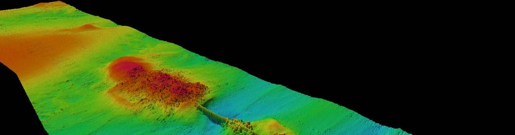
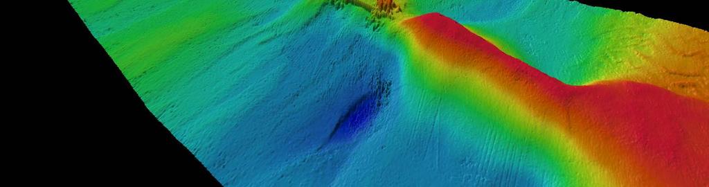
14 Risk Mitigation It may not be possible to route away from all risks Engineer the system with appropriate protection In shallow water bury the cable or up-armour In deep water increase protection (LWP,DWP) Increase burial depth according to seabed type Deep burial in selected high risk areas Exploit the potential of available tools Increase near-shore protection Horizontal directional drilling (HDD) Articulated pipe and pinning

15 Physical Routing Constraints 15

16 Physical Routing Constraints Pattern of Single Fault Incidents Multiple Fault Incidents Single Faults widespread but manageable Multiple Faults in choke points and critical 16
17 Physical Routing Constraints Landing points Proximity to cable station and terrestrial infrastructure Established cable corridors usually preferred except when diversity is important Low energy, stable beach not prone to erosion Direct landing from a cable ship preferred (15m WD < 2km)depending on currents and seabed. Access for shore end team and equipment to land the cable Route perpendicular to beach (allows more cables, shortest distance to deepwater) Avoid anchorage, harbor, dredging, environmentally sensitive areas Shelf routing Lowest fishing and anchoring risk; avoid hydrocarbon lease blocks and dredging Short distance to deepwater to minimize armor, burial and risk. Avoid rocky, abrasive seabed Find route suitable for burial if external aggression is a risk Suitable distance from active cables, crossing near 90 deg; congestion is often an issue. Limit alter course angle to 15 deg in burial, economic distance between PLUP & PLDN. 17

18 Physical Routing Constraints 18


19 conference & convention Physical Routing Illustrated 19
20 Physical Routing Constraints (Cont) Deepwater routing Great circle for shortest cable length Look for smooth flat seabed away from slopes and seamounts, avoid steep slopes and side slopes Keep suitable distance (2 x WD min) from active cables; congestion often also in deep water Avoid crossings to extent possible, cable crossing angles > 45 deg, cross away from other cable repeaters Avoid abrasive seabed and currents, use of SPA cable is such area Prefer final splice and BU placement in deeper water away from burial (1500m ideal depth) Consider using out-of-service cable route Bottom slack 2.5 to 3% plus fill slack Limit A/C to 30 deg otherwise vessel must slow to reduce layback Consider repeater placements either side of deep trench Economic cable length between transitions Consider installation and future maintenance in your routing and cable engineering 20


21 Physical Routing Constraints Earthquake Resulting Severe 300 km Mud Flow 21
22 Physical Routing Constraints Special Problems Ensuring all pipelines are known and found Databases are not complete; must rely of surveys Meeting ICPC recommendations in congested areas Not possible in many locations Accuracy of cable databases, also with regard to repair bights Owners often reluctant to disclose 22

23 Political Routing Constraints 23
24 Political Routing Constraints Minimize the number of coastal state claims especially Territorial Sea (TS) transited by the route Consider disputed claims and need for permits in overlapping claims Investigate coastal state s interpretation of UNCLOS and regulation for survey and use of foreign flag vessels Minimize length in TS (and CZ, EEZ) Consider taxes on cable and repeaters) Consider coastal state regulations in TS, CZ, EEZ. What is strength of fishing unions and expected compensation both shallow and deepwater Feedback from fishing unions is important especially in shelf routing Minimize number of active hydrocarbon lease blocks crossed 24
25 Political Routing Constraints 25
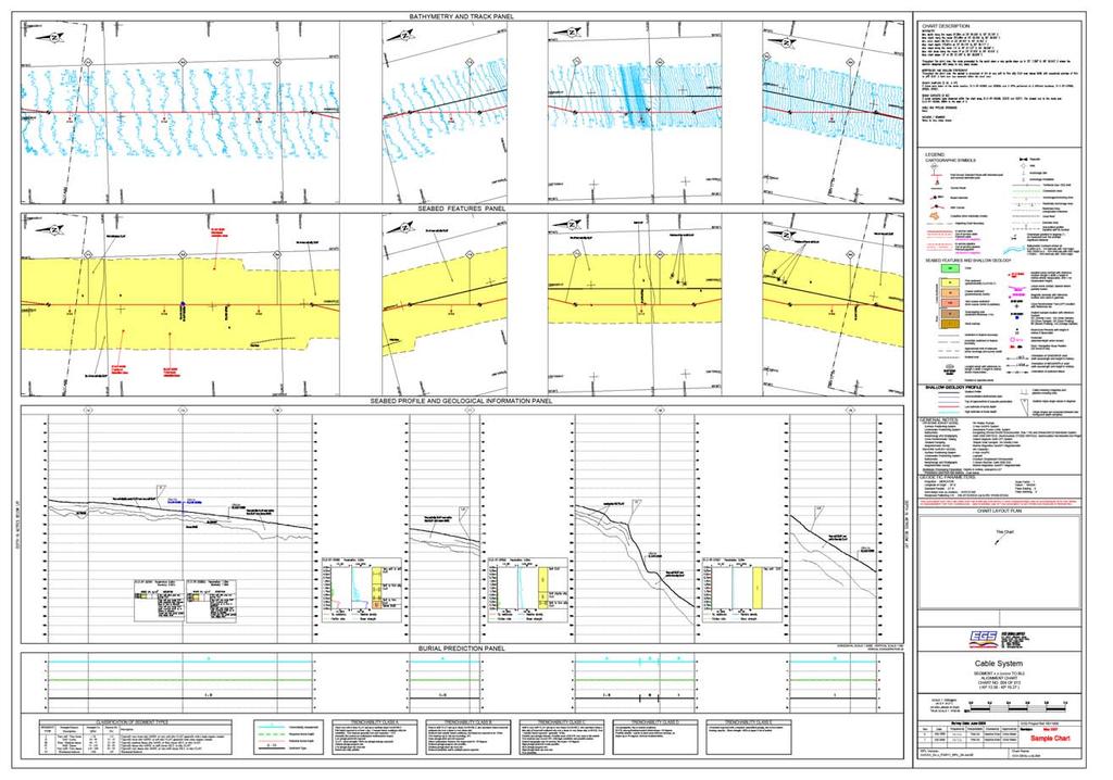
26 The Route Survey Provides information required to confirm or amend the preliminary pre survey DTS route Defines and documents the final route Enables final cable engineering to be defined Provides the system installer with the data required to finalize installation procedures Identifies potential post installation/residual hazards including unmitigated risks from potential tectonic activity during the system design life

27 conference & convention Route Survey Offshore Vessel
28 Route Survey Data Sets Data is collected along a strip of seabed, typically 500m to 3 x water depth wide and includes: Bathymetric data seabed topography Sonar imagery data seabed surface features Sub-bottom profiling data shallow sub surface soil profile Burial assessment data mechanical properties of the seabed soils within the planned burial profile (typically 1m to 3m) Geophysical and soils data usually only collected where cable protection by burial is planned typically up to a maximum water depth of 1,000m; rarely up to 2,000m Only bathymetric data collected in deep water

29 Multibeam Bathymetry Bathymetry and colocated back-scatter data Digital data output can be rapidly processed and analysed Data used to develop seabed terrain model Resolution of multibeam systems is altitude dependant
30 High Resolution in Shallow Water

31 High Resolution in Shallow Water


32 Deep water data Philippine Trench maximum depth 10,400m

33 Side Scan Sonar Imagery Towed systems Depth range up to 3000m Provide images of seabed surface features Surface back-scatter intensity can be used as indicator of seabed hardness

34 Side Scan Sonar Imagery
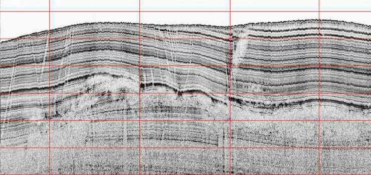
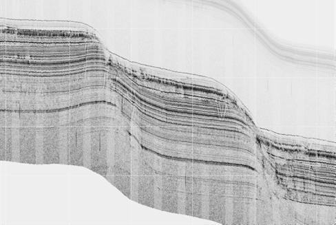
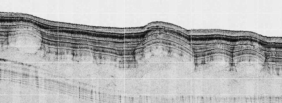
35 Sub-bottom data

36 Burial Assessment Gravity coring Cone Penetrometer Tests measure Tip resistance Sleeve friction Resistivity Typically to 3m below seabed Used to predict and categorize cable plough burial performance
 Final reporting typically office based")
37 Short reporting leadtimes have led to: On-board data acquisition, processing & charting Telemetry of processed data to shore based offices Data output direct to route planning software (Makai) Final reporting typically office based
38
39
40
 70%")


41 Cable Protection The Threat All External Aggression Faults (%) 70% 60% 50% 40% 30% 20% 10% 0% Fishing Anchors Other Abrasion Tyco Data ASN Data Dredge Geological Crushing M. Kordahi, S. Shapiro, G. Lucas, Trends in submarine Cable System Faults, SubOptic 2007 Fishing and anchoring pose the greatest risk to cable security. Cable burial remains the most effective and economical method of protection against these threats. 41
42 Cable Protection Desktop Study Route Selection Survey, Seabed Assessment, Route Refinement Burial Feasibility Study Burial Operations Cable Awareness Program Elements of of cable protection span the full project cycle! 42
43 Burial Category: A: Cable burial to a target cover depth of m; B: Cable burial to a target cover depth greater than 0.4m but less than 0.8m; C: Cable burial to a target cover depth of less than 0.4m; D: Risk of uncontrolled cable burial to a cover depth of greater than 0.8m; E: Cable burial to a target cover depth of 1.5 m in water depths of m; F: Cable burial to a target cover depth of 3 m in water depths of less than 10 m; G: Cable burial to a target cover depth of 3 m. Cable Protection Burial Example Only Deeper burial may be required in many cases Risk Category: 1: No identified risk of damage to the burial equipment due to seabed conditions; 2: Possible risk of damage to burial equipment due to seabed conditions. Scale of possible damage to be repairable on the installation vessel using shipboard equipment; 3: High risk of damage to the burial equipment due to seabed conditions. Scale of possible damage in excess of category 2. Key Elements of the BFS Seabed description Core and CPT penetration depth Hazards such as slopes, rock, boulders, coral, sand waves, soft sediment, pock marks Cable or pipeline crossings Currents that may affect plow or ROV deployment or operations Results of the integrated survey and analyses form the Burial Feasibility Study BFS is a guideline to predict burial likelihood and plow risk along the route Where seabed not conducive to burial, consider uparmor only if warranted by risk of external aggression 43


44 Cable Protection Burial Towed cable plows remain the industry standard for cable burial. Sea Stallion 3 m Plow MD3 3 m Plow Improved capability allow deeper burial and in more challenging seabed. The burial will be dictated by plow operations and reasonable endeavors ROV for Jet burial guidelines. Sea Plow 7-1.5m Plow 44
45 Maintenance Considerations Effective maintenance solution to minimise outage Club (zone) vs Private Maintenance Speed of response Base location Transit speed Strategic spares onboard not in depot Vessel performance Weather capability Maintenance and training, outside work?
46 Maintenance Considerations Post repair burial performance Age and power of ROV Enhanced burial protection protection Permitting track record Speed of response Fault prioritisation Fibre vs shunt; isolated branches vs ring systems Transmission performance Repairs should not affect upgrade-ability
47 Maintenance Considerations Commercial aspects Direct Measures Of Quality (DMOQs or SLAs) Pooling of joint kits and spare cables Tailored contracts vs standard terms Additional Services Fisheries Liaison Spare plant testing Shallow water repairs Land cable repairs

48 2010 conference & convention The 7th International Conference & Convention on Undersea Telecommunications Pacifico Convention Plaza Yokohama & InterContinental The Grand Yokohama 11 ~ 14 May
Marine Survey & Cable Routing
 Marine Survey & Cable Routing Sub Optic 2004 Short Course Ron RAPP, Mark LAWRENCE, Dick BORWICK, Takuo KUWABARA Topics Introduction/Objectives/Project Cycle Ron Rapp Desktop Study and Cable Route Study
Protection for Vessels Engaged in Servicing Submarine Cables
 Protection for Vessels Engaged in Servicing Submarine Cables Proposed Amendments to COLREGS Brief to Navigation Safety Advisory Council November 28, 2012 Tampa, FL Dr. Ronald J. Rapp TE SubCom and Representing
from ocean to cloud PARAMETRIC SUB-BOTTOM PROFILER, A NEW APPROACH FOR AN OLD PROBLEM
 PARAMETRIC SUB-BOTTOM PROFILER, A NEW APPROACH FOR AN OLD PROBLEM Geoff Holland, Alcatel-Lucent Submarine Networks Geoff.holland@alcatel-lucent.com Alcatel-Lucent Submarine Networks Ltd, Christchurch Way,
Utilizing Vessel Based Mobile LiDAR & Bathymetry Survey Techniques for Survey of Four Southern California Breakwaters
 Utilizing Vessel Based Mobile LiDAR & Bathymetry Survey Techniques for Survey of Four Southern California Breakwaters Western Dredging Association: Pacific Chapter September 2012 Insert: Pipe Location
Scottish Hydro Electric Power Distribution Operation, Inspection, Maintenance and Decommissioning Strategy Bute Cumbrae Cable Replacement
 SHEPD Section ID 154 Scottish Hydro Electric Power Distribution Operation, Inspection, Maintenance and Decommissioning Strategy Bute Cumbrae Cable Replacement Contents Definitions and Abbreviations...
Background Paper: Surveys. Nord Stream 2 AG Sep-17
 Nord Stream 2 AG Sep-17 Table of Contents Introduction... 3 Advanced Technology... 4 Survey Stages... 4 2 Introduction Survey operations are the cornerstone of massive international infrastructure projects
THE CHALLENGES OF A LARGE-AREA BATHYMETRIC SURVEY
 THE CHALLENGES OF A LARGE-AREA BATHYMETRIC SURVEY Agenda: - Introduction - Tender - Project Planning - Survey - Processing - Delivery - Conclusion 2 Introduction We know less of the oceans at our feet,
Certified Professionals in Hydrographic Solutions
 Certified Professionals in Hydrographic Solutions Client Satisfaction is our Deliverable Port of Brisbane Pty Ltd Port Surveys Certified Professionals in Hydrographic Surveying Tel +61 (0) 7 3258 4820
Acoustic Pipeline Inspection Mind The Gap
 Acoustic Pipeline Inspection Mind The Gap Mike Liddell Chief Surveyor, Fugro Survey Limited UUVS @ Oceanology 2012 13 th March 2012 Contents Menu Introduction to Pipeline Inspection The Current Toolkit
Preliminary Survey Notification and Information for Fisheries Interests.
 1) Viking Link Project The Viking Link project is a proposal to build a high voltage direct current (HVDC) electricity interconnector between the Lincolnshire Coast in the UK and Southern Jutland in Denmark
OFFSHORE SURVEY IN DEVELOPMENT PROJECTS. Ian Douglas Head, Offshore Surveys, Shell Projects & Technology Europe
 OFFSHORE SURVEY IN DEVELOPMENT PROJECTS Ian Douglas Head, Offshore Surveys, Shell Projects & Technology Europe THE PROJECT: GOLDENEYE GOLDENEYE FACTS ST. FERGUS GOLDENEYE PLATFORM Gas Condensate Field
Emerging Subsea Networks
 THE FUTURE OF MARINE SURVEY APPLICATIONS FOR SUBMARINE CABLES Ryan Wopschall (Fugro) Email: rwopschall@fugro.com Fugro Pelagos, Inc. - 3574 Ruffin Road, San Diego, California 92123 USA Abstract: New advances
from ocean to cloud HEAVY DUTY PLOUGH PERFORMANCE IN VERY SOFT COHESIVE SEDIMENTS
 HEAVY DUTY PLOUGH PERFORMANCE IN VERY SOFT COHESIVE SEDIMENTS Geoff Holland, Sarah Dzinbal (Alcatel-Lucent Submarine Networks) Email: geoff.holland@alcatel-lucent.com Alcatel-Lucent Submarine Networks
RAMSTM. 360 Riser and Anchor-Chain Integrity Monitoring for FPSOs
 RAMS 360 Riser and Anchor-Chain Integrity Monitoring for FPSOs Introduction to RAMS Tritech s RAMS is a 360 anchor-chain and riser integrity monitoring system for Floating Production Storage and Offloading
Marine Renewables Industry Association. Marine Renewables Industry: Requirements for Oceanographic Measurements, Data Processing and Modelling
 Marine Renewables Industry Association Marine Renewables Industry: Requirements for Oceanographic Measurements, Data Processing and Modelling October 2009 Table of Contents 1. Introduction... 1 2. Measurements
Failure of Wide Bay Pipeline in the Burnett River
 APGA Paper Date: 29 August 2015 Subject: Risk Mitigation for Trench Pipeline Under Shallow River Crossings Prepared by: Derek Boo Manager Planning and Engineering Company: APA Group Background: Beginning
Evolution of Deepwater Coral Protection in the Southeast U.S
 Evolution of Deepwater Coral Protection in the Southeast U.S Tina Udouj, Florida Fish and Wildlife Conservation Commission Roger Pugliese, South Atlantic Fishery Management Council Overview Deepwater Corals
HELCOM Submerged and The Nairobi International Convention. HELCOM Submerged Expert Group meeting in Bonn, Germany, 22 nd of April 2015
 HELCOM Submerged and The Nairobi International Convention HELCOM Submerged Expert Group meeting in Bonn, Germany, 22 nd of April 2015 The Nairobi International Convention on the Removal of Wrecks 2007
page - Laboratory Exercise #5 Shoreline Processes
 page - Laboratory Exercise #5 Shoreline Processes Section A Shoreline Processes: Overview of Waves The ocean s surface is influenced by three types of motion (waves, tides and surface currents). Shorelines
Design and Planning Considerations For a Seabed Survey
 Design and Planning Considerations For a Seabed Survey Vera Quinlan Hydrographer & Data Processor Seabed Survey Overview Survey Platform - What boat do I use? Survey Area / depth of water / objective &
# Post Consultation and Submissions Resource Consent Conditions for Surfing Impact Mitigation August 2016
 # Post Consultation and Submissions Resource Consent Conditions for Surfing Impact Mitigation August 2016 Surf Mitigation Management Plan 1 1 Not less than 6 months prior to the commencement of the construction
Potential applications of AUVs and Gliders in Offshore Windfarm Site Surveys
 Potential applications of AUVs and Gliders in Offshore Windfarm Site Surveys Dr James Hunt (National Oceanography Centre, Southampton) MREKE Internship in partnership with MARS at NOCS Introduction to
Dauphin Island East End Beach and Barrier Island Restoration Project. Beau Buhring South Coast Engineers
 Dauphin Island East End Beach and Barrier Island Restoration Project Beau Buhring South Coast Engineers Funding Funded with qualified outer continental shelf oil and gas revenues by the Coastal Impact
MPA proposals West of Scotland
 MPA proposals West of Scotland Purpose of this presentation Support Consultation Sites, features and management options Basis for advice WoS Site options Answer any questions Scottish MPA proposals Nov
14/10/2013' Bathymetric Survey. egm502 seafloor mapping
 egm502 seafloor mapping lecture 10 single-beam echo-sounders Bathymetric Survey Bathymetry is the measurement of water depths - bathymetry is the underwater equivalent of terrestrial topography. A transect
UTEC Survey Pipeline Inspection Using Low Logistic AUV June 2016
 SUCCESS YOU CAN MEASURE UTEC Survey Pipeline Inspection Using Low Logistic AUV June 2016 Chris Erni Product Line Manager E T H I C S P E R F O R M A N C E E X C E L L E N C E P E O P L E GLOBAL FOOTPRINT
Vieques Underwater Demonstration Project
 Vieques Underwater Demonstration Project NOAA Office of Response and Restoration National Ocean Service 2006-2007 2007 University of New Hampshire Joint Hydrographic Center 2006 Science Application International
LiDAR My favourite tool in the bag 2011 St Kitts & Nevis
 LiDAR My favourite tool in the bag 2011 St Kitts & Nevis Lt Cdr Rupert Forester-Bennett RN (ret d) December 5 th to 11 th 2011 Content Collection of geospatial data reasons Overcoming the White Ribbon
ACCESS the BLUE ECONOMY ALL OCEANS Engineering Ltd
 Subsea Expo 2018 ROV Conference 07.02.2018 ACCESS the BLUE ECONOMY The BLUE ECONOMY - DEFINITION The Blue Economy is a book by Gunter Pauli publish in 2010 based on the idea that he developed in 2004 In
Hydrographic Surveying Methods, Applications and Uses
 Definition: Hydrographic Surveying Methods, Applications and Uses It is the branch of surveying which deals with any body of still or running water such as a lake, harbor, stream or river. Hydrographic
MINE SAFETY TARGETED ASSESSMENT PROGRAM. Ground or strata failure NSW metalliferous mines. April
 MINE SAFETY TARGETED ASSESSMENT PROGRAM Ground or strata failure NSW metalliferous mines April 2017 www.resourcesandenergy.nsw.gov.au Document control Publication title: Ground or strata failure NSW metalliferous
Coastal management has lagged behind the growth in population leading to problems with pollution
 Fifty percent of the population of the industrialized world lives within 100 km of a coast. Coastal management has lagged behind the growth in population leading to problems with pollution and natural
OECS Regional Engineering Workshop September 29 October 3, 2014
 B E A C H E S. M A R I N A S. D E S I G N. C O N S T R U C T I O N. OECS Regional Engineering Workshop September 29 October 3, 2014 Coastal Erosion and Sea Defense: Introduction to Coastal Dynamics David
KY10-15 KAIYO / HYPER-DOLPHIN
 KY10-15 KAIYO / HYPER-DOLPHIN Kumano-Nada January 2011 Earthquake and Tsunami Research Project for Disaster Prevention JAMSTEC TABLE OF CONTENTS 1. INTRODUCTION 2. SCHEDULE 3. DIVE RESULTS 4. CONCLUSIONS
Cook Inlet pipeline crossing is about making the best choices
 Cook Inlet pipeline crossing is about making the best choices By Larry Persily lpersily@kpb.us Aug. 26, 2015 (This update, provided by the Kenai Peninsula Borough mayor s office, is part of an ongoing
Concepts & Phenomena
 Concepts & Phenomena in coastal and port sedimentation R. Kamalian Ports and Maritime Organization of Iran and PIANC-Iran 7 9 December 2015 What is the problem? Many harbours have sedimentation problems
ScanFish Katria. Intelligent wide-sweep ROTV for magnetometer surveys
 ScanFish Katria Intelligent wide-sweep ROTV for magnetometer surveys User-friendly control and monitoring software solution The ScanFish Katria comes with the ScanFish III Flight software, which is an
Department. «Ships and on-board Equipment» lfremer. (Head : Marc Nokin)
") Department «Ships and on-board Equipment» (Head : Marc Nokin) 1 Structuration and activities of NSE department Scope Construction and modernisation of Ifremer oceanographic ships Development of softwares
Department «Ships and on-board Equipment» (Head : Marc Nokin) 1 Structuration and activities of NSE department Scope Construction and modernisation of Ifremer oceanographic ships Development of softwares
Protectingpipelinesfor
 24 Protectingpipelinesfor Michael Paulin, Damien Humby and Joseph Cocker, INTECSEA Canada, and Glenn Lanan, INTECSEA Inc., describe the process of trenching for the protection of pipelines in ice environments.
Welcome! Did You Know...? Aquatic Centre Dock Rebuild. Key Objectives
 1 Welcome! Aquatic Centre Dock Rebuild The City of Vancouver is improving the dock at the Vancouver Aquatic Centre, which is nearing the end of its service life and is in need of replacement. This creates
Exploration and Mine Site Model Applied to Seamount Lease-Block Selection for Cobalt-Rich Crusts. James R. Hein U.S. Geological Survey For the ISA
 Exploration and Mine Site Model Applied to Seamount Lease-Block Selection for Cobalt-Rich Crusts James R. Hein U.S. Geological Survey For the ISA Introduction Parameters that ultimately will be used to
THE LIGHTS GO OUT The Ultimate Protection Technology for Protecting Submarine Cables
 THE LIGHTS GO OUT The Ultimate Protection Technology for Protecting Submarine Cables Rene van Kessel, Cor-Jan Stam (Van Oord Offshore) Email: Van Oord Offshore, 2 Jan Blankenweg, 4207HN
PIG MOTION AND DYNAMICS IN COMPLEX GAS NETWORKS. Dr Aidan O Donoghue, Pipeline Research Limited, Glasgow
 PIG MOTION AND DYNAMICS IN COMPLEX GAS NETWORKS Dr Aidan O Donoghue, Pipeline Research Limited, Glasgow A model to examine pigging and inspection of gas networks with multiple pipelines, connections and
Advanced PMA Capabilities for MCM
 Advanced PMA Capabilities for MCM Shorten the sensor-to-shooter timeline New sensor technology deployed on off-board underwater systems provides navies with improved imagery and data for the purposes of
Sensor Platform Project Marine Trials Bidders Conference. Fundy Ocean Research Center for Energy fundyforce.ca
 Sensor Platform Project Marine Trials Bidders Conference Fundy Ocean Research Center for Energy fundyforce.ca 1 Project Team FORCE OceanWorks International Preliminary Design, Operational Procedures Murray
PIPELINE SAFETY. Darin Burk, Manager Pipeline Safety. January 28, 2014
 PIPELINE SAFETY Darin Burk, Manager Pipeline Safety January 28, 2014 Congressional Delegation of Authority Pipeline Safety Act of 1968 Congress Delegated Inspection and Enforcement Authority to the Secretary
Recommended operating guidelines (ROG) for sidescan Sidescan sonar ROG in wrapper.doc English Number of pages: 9 Summary:
 for sidescan Sidescan sonar ROG in wrapper.doc English Number of pages: 9 Summary:") Title: Author(s): Document owner: Recommended operating guidelines (ROG) for sidescan sonar Dave Long (BGS) Dave Long (BGS) Reviewed by: Janine Guinan (MI) 07/09/07 Workgroup: MESH action: 2.1 Version:
Title: Author(s): Document owner: Recommended operating guidelines (ROG) for sidescan sonar Dave Long (BGS) Dave Long (BGS) Reviewed by: Janine Guinan (MI) 07/09/07 Workgroup: MESH action: 2.1 Version:
Offshore grid NL. Hollandse Kust (noord) & Hollandse Kust (west Alpha) General project introduction. 14 september 2018
 & Hollandse Kust (west Alpha) General project introduction. 14 september 2018") 1 Offshore grid NL Hollandse Kust (noord) & Hollandse Kust (west Alpha) General project introduction 14 september 2018 Offshore grid developer Four wind areas of 700 MW Planning of the Energy Agreement
1 Offshore grid NL Hollandse Kust (noord) & Hollandse Kust (west Alpha) General project introduction 14 september 2018 Offshore grid developer Four wind areas of 700 MW Planning of the Energy Agreement
Comments of Southern Cross Cables Limited on the International Seabed Authority s Exploitation Regulations
 Southern Cross Cable Network Level 5, Resimac House 45 Johnston Street, Wellington 6011 PO Box 5340 Wellington 6140, New Zealand Facsimile +64 4 499 7232 Telephone +64 4 496 3250 20 December 2017 BY ELECTRONIC
Imagine that you can see a side view of a wave as it approaches a beach. Describe how the wave changes as the wave approaches the beach.
 Geology 101 Name Reading Guide for Ch. 19: Shores and Coastal Processes (p. 612) Waves, Currents, and Tides (p. 614) Waves and Currents (p. 614) Imagine that you can see a side view of a wave as it approaches
NEED FOR SUPPLEMENTAL BATHYMETRIC SURVEY DATA COLLECTION
 305 West Grand Avenue, Suite 300 Montvale, New Jersey 07645 Phone 201.930.9890 Fax 201.930.9805 www.anchorqea.com M EMORANDUM To: Caroline Kwan and Nica Klaber U.S. Environmental Protection Agency Region
Beach Wizard: Development of an Operational Nowcast, Short-Term Forecast System for Nearshore Hydrodynamics and Bathymetric Evolution
 Beach Wizard: Development of an Operational Nowcast, Short-Term Forecast System for Nearshore Hydrodynamics and Bathymetric Evolution Ad Reniers Civil Engineering and Geosciences, Delft University of Technology
INTERNATIONAL HYDROGRAPHIC SURVEY STANDARDS
 INTERNATIONAL HYDROGRAPHIC SURVEY STANDARDS by Gerald B. MILLS 1 I. Background The International Hydrographic Organization (IHO) traces its origin to the establishment of the International Hydrographic
OTC MS. Free Span Rectification by Pipeline Lowering (PL) Method N. I. Thusyanthan, K. Sivanesan & G. Murphy
 Method N. I. Thusyanthan, K. Sivanesan & G. Murphy") OTC-24699-MS Free Span Rectification by Pipeline Lowering (PL) Method N. I. Thusyanthan, K. Sivanesan & G. Murphy Copyright 2014, Offshore Technology Conference This paper was prepared for presentation
OTC-24699-MS Free Span Rectification by Pipeline Lowering (PL) Method N. I. Thusyanthan, K. Sivanesan & G. Murphy Copyright 2014, Offshore Technology Conference This paper was prepared for presentation
HARBOUR SEDIMENTATION - COMPARISON WITH MODEL
 HARBOUR SEDIMENTATION - COMPARISON WITH MODEL ABSTRACT A mobile-bed model study of Pointe Sapin Harbour, in the Gulf of St. Lawrence, resulted in construction of a detached breakwater and sand trap to
Physical Modeling of Nearshore Placed Dredged Material Rusty Permenter, Ernie Smith, Michael C. Mohr, Shanon Chader
 Physical Modeling of Nearshore Placed Dredged Material Rusty Permenter, Ernie Smith, Michael C. Mohr, Shanon Chader Research Hydraulic Engineer ERDC-Coastal Hydraulics Laboratory October 25,2012 Study
The Evolution of an Autonomous Unmanned Surface Vessel and Software for Hydrographic Survey
 The Evolution of an Autonomous Unmanned Surface Vessel and Software for Hydrographic Survey Paul Donaldson In 2017, Leidos, Inc. participated in both the Gulf of Mexico Unmanned Systems Operational Demonstration
An Integrated Marine Gradiometer Array System (MGA)
") An Integrated Marine Gradiometer Array System (MGA) For Detection and Location of Chemical and Conventional UXO/MEC in Shallow to Deep Marine and Freshwater Environments Introduction Tetra Tech EC, Inc.
An Integrated Marine Gradiometer Array System (MGA) For Detection and Location of Chemical and Conventional UXO/MEC in Shallow to Deep Marine and Freshwater Environments Introduction Tetra Tech EC, Inc.
Body Search and Recovery Using Sonar
 Body Search and Recovery Using Sonar Photos Mark W. Atherton Mark W. Atherton, Echoes and Images Image courtesy FBI Dive Team Images not for distribution. All photographs and drawings courtesy and Mark
CHAPTER 7.0 IMPLEMENTATION
 CHAPTER 7.0 IMPLEMENTATION Achieving the vision of the Better Streets Plan will rely on the ability to effectively fund, build and maintain improvements, and to sustain improvements over time. CHAPTER
TAT 14 (Segment K) North Western Approaches
 North Western Approaches") Cable Awareness & Emergency Procedures Please keep clear and do not damage submarine telecoms cables. You risk the loss of your gear and catch, and international communications can be disrupted. These
Cable Awareness & Emergency Procedures Please keep clear and do not damage submarine telecoms cables. You risk the loss of your gear and catch, and international communications can be disrupted. These
INTRODUCTION TO COASTAL ENGINEERING
 The University of the West Indies Organization of American States PROFESSIONAL DEVELOPMENT PROGRAMME: COASTAL INFRASTRUCTURE DESIGN, CONSTRUCTION AND MAINTENANCE A COURSE IN COASTAL DEFENSE SYSTEMS I CHAPTER
Shorelines Earth - Chapter 20 Stan Hatfield Southwestern Illinois College
 Shorelines Earth - Chapter 20 Stan Hatfield Southwestern Illinois College The Shoreline A Dynamic Interface The shoreline is a dynamic interface (common boundary) among air, land, and the ocean. The shoreline
MECHANICAL ASPECTS OF SUBMARINE CABLE ARMOUR
 MECHANICAL ASPECTS OF SUBMARINE CABLE ARMOUR Ernesto Zaccone ARMORING OF SUBMARINE CABLES Submarine cables must be robust Mechanical aspects are at least as important as the electrical o nes Must withstand
Point LaBarbe/McGulpin Point Response April 2 May 8, 2018 Regional Response Team 3 Meeting November, 2018
 Point LaBarbe/McGulpin Point Response April 2 May 8, 2018 Regional Response Team 3 Meeting November, 2018 TJ Mangoni District Response Advisory Team Supervisor Ninth Coast Guard District 216-214-4285 Summary
Evaluation of the Klein HydroChart 3500 Interferometric Bathymetry Sonar for NOAA Sea Floor Mapping
 Evaluation of the Klein HydroChart 3500 Interferometric Bathymetry Sonar for NOAA Sea Floor Mapping Yuhui Ai, Straud Armstrong and Dean Fleury L-3 Communications Klein Associates, Inc. 11 Klein Dr. Salem,
Oceans and Coasts. Chapter 18
 Oceans and Coasts Chapter 18 Exploring the oceans The ocean floor Sediments thicken and the age of the seafloor increases from ridge to shore The continental shelf off the northeast United States Constituent
Deep-sea coral protection zones and management measures
 Deep-sea coral protection zones and management measures This presentation was originally provided to the New England Fishery Management Council on April 26, 2012 in Mystic, CT. Recent updates related to
AGGREGATE DREDGING AND THE MARINE ENVIRONMENT
 AGGREGATE DREDGING AND THE MARINE ENVIRONMENT The marine Aggregate Levy Sustainability Fund ( marine ALSF ) programme represents one of the most substantial investments in UK marine research. The research
Taranaki Tsunami Inundation Analysis. Prepared for Taranaki Civil Defence Emergency Management Group. Final Version
 Taranaki Tsunami Inundation Analysis Prepared for Taranaki Civil Defence Emergency Management Group Final Version June 2012 AM 12/07 HBRC Plan Number 4362 Asset Management Group Technical Report Prepared
TECHNICAL BULLETIN PINPOINT CONDUIT COUPLING AND SPLICING RECOMMENDATIONS
 TECHNICAL BULLETIN PINPOINT CONDUIT COUPLING AND SPLICING RECOMMENDATIONS CONTENTS: 1.0 General Information 2.0 Preparation and Splicing of PinPoint Wire 3.0 PinPoint Direct Bury Splice Kit Specifications
Submarine Cables as a Sustainable Use of the Deep Sea Environment
 Submarine Cables as a Sustainable Use of the Deep Sea Environment International Cable Protection Committee ( ICPC ) BBNJ IGC 1 Side Event September 13, 2018 1 About ICPC Founded in 1958, ICPC is the world
Hydrographic Surveying at The Port of London
 Hydrographic Surveying at The Port of London John Dillon-Leetch Port and Terminal Technology 2009 14 th October, Antwerp Overview Introduction Surveying the Thames Navigational Charting High Resolution
Door County, WI Coastal Hazard Analysis Flood Risk Review Meeting. August 21, 2017
 Door County, WI Coastal Hazard Analysis Flood Risk Review Meeting August 21, 2017 Agenda Introductions Coastal Flood Risk Study and Mapping Program Current Status Technical Overview of Study and Mapping
BOTTOM MAPPING WITH EM1002 /EM300 /TOPAS Calibration of the Simrad EM300 and EM1002 Multibeam Echo Sounders in the Langryggene calibration area.
 BOTTOM MAPPING WITH EM1002 /EM300 /TOPAS Calibration of the Simrad EM300 and EM1002 Multibeam Echo Sounders in the Langryggene calibration area. by Igor Kazantsev Haflidi Haflidason Asgeir Steinsland Introduction
Town of Duck, North Carolina
 Tracking No. 00.00.2010 Erosion Mitigation And Shoreline Management Feasibility Study Town of Duck, North Carolina Coastal Planning & Engineering of North Carolina August 15, 2012 Tom Jarrett Robert Neal
Morphodynamics of Borssele Wind Farm Zone
 Morphodynamics of Borssele Wind Farm Zone Meeting Tender Borssele Hendrik Jan Riezebos Tommer Vermaas Robert Hasselaar Tim Raaijmakers 17 November 2014, SER Den Haag Contents of presentation Introduction
1 st Tidal and Water Level Working Group Meeting DHN, Niteroi, Brazil 31/03/09 02/04/09 Vertical Offshore Reference Framework (VORF) Chris Jones
 Chris Jones") 1 st Tidal and Water Level Working Group Meeting DHN, Niteroi, Brazil 31/03/09 02/04/09 Vertical Offshore Reference Framework (VORF) Chris Jones United Kingdom Hydrographic Office Presentation Structure
1 st Tidal and Water Level Working Group Meeting DHN, Niteroi, Brazil 31/03/09 02/04/09 Vertical Offshore Reference Framework (VORF) Chris Jones United Kingdom Hydrographic Office Presentation Structure
W I L D W E L L C O N T R O L PRESSURE BASICS AND CONCEPTS
 PRESSURE BASICS AND CONCEPTS Pressure Basics and Concepts Learning Objectives You will be familiarized with the following basic pressure concepts: Defining pressure Hydrostatic pressure Pressure gradient
Comparison of Predicted and Measured Shoaling at Morro Bay Harbor Entrance, California
 Comparison of Predicted and Measured Shoaling at Morro Bay Harbor Entrance, California by Edward F. Thompson, Inocencio P. DiRamos, and Robert R. Bottin, Jr. PURPOSE: This Coastal and Hydraulics Engineering
COMPENSATION LAKE DESIGN CONCEPTS AND CONSTRUCTION LESSONS LEARNED
 SMA Environmental Forum 2016 COMPENSATION LAKE DESIGN CONCEPTS AND CONSTRUCTION LESSONS LEARNED Month A Tale DD, of YYYY Two Lakes Pamela Kuipers, P.Eng., MSc EXPLORE the Depths of our Experience www.norwestcorp.com
from ocean to cloud SHORELINE EROSION AND IMPACT TO CABLE PROTECTION
 SHORELINE EROSION AND IMPACT TO CABLE PROTECTION Thomas E. Schaefer Jr. (TE SubCom), David Blau (TE SubCom), Ana Chamon (TE SubCom), Agustin Gutierrez Arroyo (Telefónica Global Solutions) Email: teschaefer@subcom.com
3.9 FROM ISLANDS TO ATOLLS
 3.9 1 3.9 FROM ISLANDS TO ATOLLS OBJECTIVES The students Listen to a description of the formation of volcanic islands, fringing reefs, barrier reefs, and atolls. Observe and participate in a simulation
Polar Research Vessel Operational Requirements and Summary of Technical Studies
 Polar Research Vessel Operational Requirements and Summary of Technical Studies Presentation to UNOLS by Jim St John Science and Technology Corporation - Polar Technology Office Why a New Antarctic Research
Case Study 3. Case Study 3: Cebu Island, Philippines MPA Network 10
 Case studies of mpa networks Case Study 3: Cebu Island, Philippines MPA Network 10 Location and background Cebu Island in the Philippines lies in the center of the Visayan Islands, known as an area high
City of Burnaby Environmental Review Committee (ERC) Guide for Applicants
 Guide for Applicants") City of Burnaby Environmental Review Committee (ERC) Guide for Applicants 2017-2018 This Guide summarizes the ERC process for project review including applications for a relaxation (variance) to the development
City of Burnaby Environmental Review Committee (ERC) Guide for Applicants 2017-2018 This Guide summarizes the ERC process for project review including applications for a relaxation (variance) to the development
Nemo Link s puxo campaign
 BLOCK 3 BLOCK 2 U e c n France 400000 570000 KP 0 KP 10 KP 20 KP 30 a r F 565000 BLOCK 1 450000 Belgique 0 5 ONGOING 10 15 20 km N 565000 t i n g n i K Nearshore BE Fra m o d ed KP 50 KP 60 KP 70 KP 80
Moving beyond BACI: What do to when science and reality clash in marine reserve monitoring? Workshop Held: June 10 th, 2015
 Moving beyond BACI: What do to when science and reality clash in marine reserve monitoring? Workshop Held: June 10 th, 2015 Challenges have arisen when implementing a BACI (Before-After-Control-Impact)
Challenges in determining water surface in airborne LiDAR topobathymetry. Amar Nayegandhi, Dewberry 15 th Annual JALBTCX Workshop, June 11 th 2014
 Challenges in determining water surface in airborne LiDAR topobathymetry Amar Nayegandhi, Dewberry 15 th Annual JALBTCX Workshop, June 11 th 2014 Why topobathy LiDAR? Complements acoustic (multi-beam sonar)
COMPARISON OF DEEP-WATER ADCP AND NDBC BUOY MEASUREMENTS TO HINDCAST PARAMETERS. William R. Dally and Daniel A. Osiecki
 COMPARISON OF DEEP-WATER ADCP AND NDBC BUOY MEASUREMENTS TO HINDCAST PARAMETERS William R. Dally and Daniel A. Osiecki Surfbreak Engineering Sciences, Inc. 207 Surf Road Melbourne Beach, Florida, 32951
SHUTTLE-SUBs ALL OCEANS Engineering Ltd
 SUK Underwater Vehicles Conference 21.11.17 SHUTTLE-SUBs AC-ROV 3000m Fly-out System Introduced in 2011 MAC-ROV 6000m Fly-out System (2017) 6000m, 4k and HD cameras, SM fibre telemetry Expandable architecture,
Offshore engineering science
 Offshore engineering science In this research stream theoretical models advanced geotechnical models and new numerical techniques were used in applied offshore engineering topics such as loading, design
S-44 edition 5 The IHO s New Standard For Hydrographic Surveys Chris Howlett Head of Seabed Data Centre United Kingdom Hydrographic Office
 S-44 edition 5 The IHO s New Standard For Hydrographic Surveys Chris Howlett Head of Seabed Data Centre United Kingdom Hydrographic Office Chairman of IHO Working Group that created S-44 edition 5 S-44
Learn more at
 Full scale model tests of a steel catenary riser C. Bridge 1, H. Howells 1, N. Toy 2, G. Parke 2, R. Woods 2 1 2H Offshore Engineering Ltd, Woking, Surrey, UK 2 School of Engineering, University of Surrey,
Advanced Surf Kayak Leader Training Notes
 Advanced Surf Kayak Leader Training Notes Part A Personal Paddling Skills A.1 Lifting, carrying, launching and landing The type of break surfed at this level will mean the application of a large variation
Geospatial Positioning Accuracy Standards Part 5: Standards for Nautical Charting Hydrographic Surveys - Public Review Draft
 Appendix B FGDC Hydrographic Accuracy Standard Geospatial Positioning Accuracy Standards Part 5: Standards for Nautical Charting Hydrographic Surveys - Public Review Draft Subcommittee on Marine and Coastal
Seal Extension Guidelines. Asset Management and Systems
 Seal Extension Guidelines 1. Guideline Definitions AADT - Annual Average Daily Traffic is measured at regular annual (or greater) intervals and adjusted for seasonal effects, using an approved traffic
CONDUCT OF MOBILE DRILLING RIG SITE SURVEYS. Volume 2
 UK OFFSHORE OPERATORS ASSOCIATION LIMITED (SURVEYING & POSITIONING COMMITTEE) Guidelines for CONDUCT OF MOBILE DRILLING RIG SITE SURVEYS Volume 2 Issue 1 While Regulations clearly establish a requirement
Implications of proposed Whanganui Port and lower Whanganui River dredging
 PO Box 637 Wanganui 4540 Attention: Rowan McGregor Dear Rowan 1 Summary We understand that it has been proposed to bring large vessels into the Port at Whanganui requiring the excavation of a channel up
An IOOS Operational Wave Observation Plan Supported by NOAA IOOS Program & USACE
 An IOOS Operational Wave Observation Plan Supported by NOAA IOOS Program & USACE R.E. Jensen, W.A. Birkemeier and W. Burnett JCOMM-Workshop on Wave Measurements from Buoys Wave Information to Application