1. Indicate the number of employees and supervisors who will be working on the site. 5-10
|
|
|
- Duane Lamb
- 5 years ago
- Views:
Transcription
1 28068
2
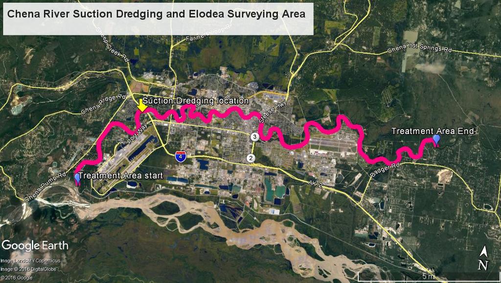
3 Site Description continued - Describe the natural vegetation --- ground cover, trees, shrubs --- and any proposed changes. Describe the location of any estuarine, riparian, or wetlands and any noticeable animal use of area. The proposed site and all potential additional sites where Elodea may be detected, are located in the lower portion of the Chena River which is heavily urbanized. At the proposed site, surrounding vegetation includes black spruce, willows, aspen, birch, and shrubs such as prickly rose. No changes to terrestrial vegetation are proposed. Animals that may use the area are moose, hare, squirrels, and beavers. Waterfowl, raptors, and songbirds are also likely to be present in the surrounding area. Site Access - Describe how you plan to access the site, and your mode of transportation. The site will be accessed by boat. The pontoon barge with suction dredge apparatus will be parked at the Tanana Chief boat launch site, and the proposed site will be accessed from there. If your access is by aircraft, specify the type and size of aircraft: NA To access the site, the aircraft is equipped with floats [ ] wheels [ ] skis [ ]. Number of people 1. Indicate the number of employees and supervisors who will be working on the site Indicate the number of customers who will be using the site per year or season Indicate the number of days the site will be used per year or season. 90 days Environmental Risk / Hazardous Substances - In the course of your proposed activity will you generate, use, store, transport, dispose of, or otherwise come in contact with toxic and/or hazardous materials, and/or hydrocarbons? Yes[ x] No[]. If yes, please describe: During the proposed activity, there will be limited (approx gallons is needed for a season) refuelling of the barge. The types and volumes of fuel or other hazardous substances present or proposed: The pontoon barge on which the suction dredge is mounted may need to be refuelled during the course of suction dredging activities. The activities will produce a small amount of fuel emissions to the air. The specific storage location(s): Fuel will collected in a 5 gallon gas can from a gas station and brought onto the barge for refuelling as needed. The spill plan and prevention methods: A very limited amount of fuel is needed for the project activities (5-10 gallons). At such time that refuelling is needed, gas will be transferred to the gas tank from a 5 gallon gas can carefully with the help of a funnel. If there is any spillage, the spill will be cleaned up immediately with absorbent pads. Land Use Permit Application A (Rev.03/13) Receipt Type FF (Non-Guide) or 7A (Guide) Page 3 of 4
4 04/10/2017
5 Project Description Elodea is a harmful invasive species that grows in dense vegetative mats, impedes boat travel, and degrades native fish habitat. If it spreads downstream from the Chena River and enters the Tanana and Yukon drainages, it could infest areas further downstream and damage sensitive fisheries. The purpose of the proposed project is to remove the aquatic invasive plant Elodea from one known location along the Chena River using a diver-assisted suction dredge system. In each year of the project, dive surveys for Elodea will be conducted in the Chena River, between its mouth and the mouth of Chena Slough. If any additional rooted patches of Elodea are found in the river, they will be removed using suction dredging. The suction dredging system consists of a sluiceway box with an attached intake hose and dredge motor mounted on top of a pontoon boat. For suction dredging, a SCUBA diver stays anchored and feeds the plant material into the 4 inch diameter suction hose nozzle. The plant material along with some adhering sediment gets sucked through the hose into the sluiceway box where it is collected in mesh bags at three terminals. The purpose of this procedure is to remove plant material, though water and some sediment that is adhering to the plant material may also be sucked up.
6 20 ft CHENA RIVER SUCTION DREDGING OF ELODEA PLAN VIEW Chena River N DRAINAGE FLOW Suction dredging apparatus on pontoon boat 4 diameter suction hose Patch of Elodea- plant material to be removed Floating boom for collection of plant fragments 20 ft
7 CHENA RIVER SUCTION DREDGING OF ELODEA CROSS- SECTION VIEW N Plant material (Elodea) to be suction dredged and removed from waterway RIVERBANK Suction dredge apparatus with 4 diameter intake hose mounted on pontoon boat WATER LEVEL Maximum depth of sediment that may be sucked Up along with plant material is ft
8
STATE OF ALASKA DEPARTMENT OF NATURAL RESOURCES DIVISION OF MINING, LAND AND WATER LAND USE PERMIT APPLICATION AS
 STATE OF ALASKA DEPARTMENT OF NATURAL RESOURCES DIVISION OF MINING, LAND AND WATER LAND USE PERMIT APPLICATION AS 38.05.850 Applicants must complete all sections of this application. In addition, applicants
Aquatic Invasive Species : Update on AIS related efforts at Deep Creek Lake, Maryland
 Aquatic Invasive Species : Update on AIS related efforts at Deep Creek Lake, Maryland Presentation to the DCL Property Owners Association August 19, 2017 Julie Bortz Maryland Department of Natural Resources
Starry Stonewort in Silver Lake Washington County, WI BRAD STECKART AIS COORDINATOR FOR WASHINGTON AND WAUKESHA COUNTIES
 Starry Stonewort in Silver Lake Washington County, WI BRAD STECKART AIS COORDINATOR FOR WASHINGTON AND WAUKESHA COUNTIES Brad Steckart -AIS coordinator for Washington and Waukesha Counties -Graduated from
Management of Hybrid Watermilfoil (Myriophyllum sibericum x spicatum) using Diver Assisted Suction Harvesting
 using Diver Assisted Suction Harvesting") 2527 Lake Ottawa Road Iron River, MI 49935 906.284.2198 Management of Hybrid Watermilfoil (Myriophyllum sibericum x spicatum) using Diver Assisted Suction Harvesting Lake Ellwood, Florence, WI - 2014 Final
2527 Lake Ottawa Road Iron River, MI 49935 906.284.2198 Management of Hybrid Watermilfoil (Myriophyllum sibericum x spicatum) using Diver Assisted Suction Harvesting Lake Ellwood, Florence, WI - 2014 Final
Summary of Diver Assisted Suction Harvesting Efforts. Lake Ellwood Florence County, WI
 2527 Lake Ottawa Road Iron River, MI 49935 906.284.2198 Summary of Diver Assisted Suction Harvesting Efforts Lake Ellwood Florence County, WI 2015 WDNR Mechanical Harvesting Permit Annual Report Permit
Eurasian water-milfoil (Myriophyllum spicatum) SCUBA Dive Monitoring Survey Sand Bar Lake WBIC: Bayfield County, Wisconsin
 SCUBA Dive Monitoring Survey Sand Bar Lake WBIC: Bayfield County, Wisconsin") Eurasian water-milfoil (Myriophyllum spicatum) SCUBA Dive Monitoring Survey Sand Bar Lake WBIC: 2494900 Bayfield County, Wisconsin 6ft EWM Towers with Rooted Branch Preparing to Fall Off (Berg 2016) EWM
Eurasian water-milfoil (Myriophyllum spicatum) SCUBA Dive Monitoring Survey Sand Bar Lake WBIC: 2494900 Bayfield County, Wisconsin 6ft EWM Towers with Rooted Branch Preparing to Fall Off (Berg 2016) EWM
Chateaugay Lakes Milfoil Control Program
 Chateaugay Lakes Milfoil Control Program Summary of Activities and Findings for June August 29 Prepared By: Daniel L. Kelting Executive Director Adirondack Watershed Institute Paul Smith's College P.O.
Biosecurity Protocol for Field Survey Work
 Biosecurity Protocol for Field Survey Work Invasive species are an ever present threat in our aquatic and riparian systems and it is imperative that none of our field operations exacerbate the risks to
DIVING AS A TECHNIQUE TO CONTROL EXOTIC AQUATIC PLANTS: THE WEED CONTROL DIVER PROGRAM
 DIVING AS A TECHNIQUE TO CONTROL EXOTIC AQUATIC PLANTS: THE WEED CONTROL DIVER PROGRAM PREPARED BY: NEW HAMPSHIRE DEPARTMENT OF ENVIRONMENTAL SERVICES EXOTIC SPECIES PROGRAM 29 HAZEN DRIVE CONCORD, NH
Starry Stonewort (Nitellopsis obtusa) Removal Using Diver Assisted Suction Harvesting
 Removal Using Diver Assisted Suction Harvesting") Starry Stonewort (Nitellopsis obtusa) Removal Using Diver Assisted Suction Harvesting Silver Lake, Washington County, WI Brad Steckart, Aquatic Invasive Species Coordinator for Washington and Waukesha
Starry Stonewort (Nitellopsis obtusa) Removal Using Diver Assisted Suction Harvesting Silver Lake, Washington County, WI Brad Steckart, Aquatic Invasive Species Coordinator for Washington and Waukesha
Big Spring Creek Habitat Enhancement and Fishery Management Plans
 Big Spring Creek Habitat Enhancement and Fishery Management Plans November 5, 2012 Big Spring Events and Activities Center Newville, PA Charlie McGarrell Regional Habitat Biologist Pennsylvania Fish and
Illinois Lake Management Association Conference March 23, 2018 By Trent Thomas Illinois Department of Natural Resources Division of Fisheries
 Illinois Lake Management Association Conference March 23, 2018 By Trent Thomas Illinois Department of Natural Resources Division of Fisheries Sources of Habitat Impairment Sedimentation Channelization
CASITAS MWD NOVEMBER
 Quagga Mussels: Threat to Western W Ventura County Water Supplies, Economy and Recreation CASITAS MWD NOVEMBER 2007 1 CASITAS MUNICIPAL WATER DISTRICT 1055 VENTURA AVENUE OAK VIEW, CALIFORNIA 93022 (805)
Osoyoos Lake Aquatic Plant Mapping
 Osoyoos Lake Aquatic Plant Mapping AquaTechnex, LLC Presented to Okanogan County NWCB by PO Box 30824 Bellingham WA, 98228 www.aquatechnex.com Introductions Myriophyllum spicatum or Eurasian Milfoil has
FACT SHEET MCGREGOR LAKE RESTORATION HABITAT PROJECT POOL 10, UPPER MISSISSIPPI RIVER, WISCONSIN ENVIRONMENTAL MANAGEMENT PROGRAM
 FACT SHEET MCGREGOR LAKE RESTORATION HABITAT PROJECT POOL 10, UPPER MISSISSIPPI RIVER, WISCONSIN ENVIRONMENTAL MANAGEMENT PROGRAM LOCATION McGregor Lake is located within a mid-river island in Pool 10
ZEBRA MUSSEL MONITORING Guidelines for Stream Teams
 ZEBRA MUSSEL MONITORING Guidelines for Stream Teams How Stream Teams can help track the status of Missouri s latest threat to streams and lakes Zebra Mussels Are Here! Missouri has had its share of exotic
Site Tour, August 24, Fish Science - Big Lake Coho Salmon Migration and Habitat Use
 Matanuska-Susitna Basin Salmon Habitat Partnership Site Tour, August 24, 2015 Part 1 of Tour Big Lake watershed Fish Science - Big Lake Coho Salmon Migration and Habitat Use Presenter: Jon Gerken (U.S.
At Home on the Elbow River. -Ours to share-
 At Home on the Elbow River -Ours to share- Living in the shed You are part of the Elbow River Watershed. The Elbow River and its tributaries drain over 1,200 km² of land. The source of the Elbow River
Marine Ecosystems. Aquatic Ecosystems Section 2
 Marine Ecosystems Marine ecosystems are located mainly in coastal areas and in the open ocean. Organisms that live in coastal areas adapt to changes in water level and salinity. Organisms that live in
GOAL: Collect product flowing over Onalaska spillway to protect downstream resources C&C 250 Y Y. Looking upstream at spillway
 GOAL: Collect product flowing over Onalaska spillway to protect downstream resources BR5 Black n/a Onalaska Spillway Carry- In C&C 250 Y Y Looking upstream at spillway Implementation (Go to Aerial View)
Dexter Marsh Wildlife Management Area and Muskellunge Creek: Water Hyacinth (Eichhornia crassipes) Assessment
 Assessment") St. Lawrence Eastern Lake Ontario Partnership for Regional Invasive Species Management Special Note The partners of the SLELO PRISM have identified 2 Priority Conservation Areas on which we conduct early
St. Lawrence Eastern Lake Ontario Partnership for Regional Invasive Species Management Special Note The partners of the SLELO PRISM have identified 2 Priority Conservation Areas on which we conduct early
X.B WETLANDS ROGUE RIVER ESTUARY
 X.B WETLANDS ROGUE RIVER ESTUARY The Rogue River has a drainage area of 5,100 square miles, yet the estuary of the Rogue River is one of the smallest in Oregon, measuring approximately 1,880 acres during
Dredging Keeping Our Underwater Highways Open
 Dredging Keeping Our Underwater Highways Open Sedimentation Material that falls to the bottom of a liquid is called sediment. If enough sediment deposits to build a shallow spot on the river or ocean bottom,
Manual of Fisheries Survey Methods II: with periodic updates. Chapter 22: Guidelines for Sampling Warmwater Rivers with Rotenone
 Manual of Fisheries Survey Methods II: with periodic updates : Guidelines for Sampling Warmwater Rivers with Rotenone P. W. Seelbach, G. L. Towns, and D. D. Nelson Suggested citation: Seelbach, Paul W.,
INADVERTENT RETURN PLAN FOR HORIZONTAL DIRECTIONAL DRILLING (HDD)
") INADVERTENT RETURN PLAN FOR HORIZONTAL DIRECTIONAL DRILLING (HDD) FACILITY OPERATOR: NextEra Energy Resources, LLC 700 Universe Boulevard Juno Beach, FL 33408 For Horizontal Directional Drilling Contents
INADVERTENT RETURN PLAN FOR HORIZONTAL DIRECTIONAL DRILLING (HDD) FACILITY OPERATOR: NextEra Energy Resources, LLC 700 Universe Boulevard Juno Beach, FL 33408 For Horizontal Directional Drilling Contents
Riding Mountain National Park Fishing Regulations Summary
 Riding Mountain National Park Fishing Regulations Summary Riding Mountain Fishing Regulations Summary Key Reminders : All National Parks of Canada Fishing Regulations apply A Riding Mountain National Park
INFORMATION FOR THE PUBLIC ABOUT A COMAH ESTABLISHMENT
 INFORMATION FOR THE PUBLIC ABOUT A COMAH ESTABLISHMENT Information for the public about an establishment subject to the Control of Major Accident Hazards Regulations 2015 (COMAH) The system to provide
Delineation of the Asian Clam (Corbicula fluminea) Population at Sand Harbor State Park, Nevada
 Population at Sand Harbor State Park, Nevada") Delineation of the Asian Clam (Corbicula fluminea) Population at Sand Harbor State Park, Nevada Report to the Nevada Division of State Lands and the Tahoe Regional Planning Agency Final Draft Brant Allen,
Delineation of the Asian Clam (Corbicula fluminea) Population at Sand Harbor State Park, Nevada Report to the Nevada Division of State Lands and the Tahoe Regional Planning Agency Final Draft Brant Allen,
Flowering Rush An Invasive Aquatic Macrophyte Infesting the Columbia River Basin
 Flowering Rush An Invasive Aquatic Macrophyte Infesting the Columbia River Basin Virgil Dupuis Salish Kootenai College Peter Rice University of Montana Pacific Northwest Distribution Montana Distribution
SGS MUSCOWPETUNG ABORIGINAL CONSTRUCTION MONITORING
 SGS MUSCOWPETUNG ABORIGINAL CONSTRUCTION MONITORING WEEKLY REPORT SPREAD# 5 SEPTEMBER 24 TH TO SEPTEMBER 30 TH, 2018 Page 1 of 8 Field Observation Social and Cultural Features # of occurrences Traditional
SECTION #1. What is Watercraft Inspection?
 SECTION #1 What is Watercraft Inspection? 1:1 Recreational boating is identified as a key pathway in the spread of aquatic invasive species (AIS) across the Great Lakes Basin including inland waterbodies
Floating Pennywort Project. River Medway and River Cray locations
 Floating Pennywort Project River Medway and River Cray locations 2011 Andrea Griffiths (BSc) Partnership Officer Medway Valley Countryside Partnership MVCP Floating Pennywort Report 2011 Andrea Griffiths
Estuary Manager. Estuary Manager. Estuary Manager. Estuary Manager
 You own a motorboat in the St. Louis River estuary. You think it is best to: Have fun on your boat. Sometimes this means breaking rules and going faster than the limits. People speed in their cars all
FACT SHEET I. LOCATION
 STEAMBOAT ISLAND HABITAT REHABILITATION AND ENHANCEMENT PROJECT (HREP) SCOTT COUNTY, IOWA, UPPER MISSISSIPPI RIVER RESTORATION-ENVIRONMENTAL MANAGEMENT PROGRAM ROCK ISLAND DISTRICT FACT SHEET I. LOCATION
Mid-Columbia Fisheries Enhancement Group Annual Report Fiscal Year 06: July 1, 2005 June 30, 2006
 Mid-Columbia Fisheries Enhancement Group Annual Report Fiscal Year 06: July 1, 2005 June 30, 2006 Mission Statement The mission of the Mid-Columbia Fisheries Enhancement Group is to restore self-sustaining
Otto E. Langer - Fisheries Biologist and Aquatic Ecologist. October 15, 2014.
 Social and Environmental Values in the Fraser River and Estuary in the Sandheads to Annacis Island Reach In Relationship to the Risks Caused by the Approved VAFFC* Proposal to Ship Jet Fuel into the Fraser
Marine Environment Plans
 Marine Environment Plans 1 Marine Sediment Management Plan 2 Marine Sediment Management Plan: Overview What The Marine Sediment Management Plan (MSMP) describes management of marine sediment disturbed
Blakely Island, N Thatcher Bay. Restoration Recommendation: Rank Score (total score)
") Soft Shore Protection/Structure Removal Blueprint for San Juan County Forage Fish Beaches Appendix 2: Recommendations for sites scoring below the top ten, sorted by island (east to west) Blakely Island,
Soft Shore Protection/Structure Removal Blueprint for San Juan County Forage Fish Beaches Appendix 2: Recommendations for sites scoring below the top ten, sorted by island (east to west) Blakely Island,
Charlottetown Marine Terminal Pipeline Decommissioning Project Description
 Charlottetown Marine Terminal Pipeline Decommissioning Project Description 69 Marr Road Unit B Rothesay NB, E2E 3J9 Tel (506) 848-1920 Fax (506) 848-1929 Charlottetown Marine Terminal Pipeline Decommissioning
Rob Tewes Senior Aquatic Biologist; ORSANCO. The Ohio River Valley Water Sanitation Commission (ORSANCO) Biological and Research Programs
 Biological and Research Programs") Rob Tewes Senior Aquatic Biologist; ORSANCO Background The Ohio River has been subject to invasions from exotic aquatic species since at least the mid to late 1800 s when Common Carp began gaining a foot-hold
Rob Tewes Senior Aquatic Biologist; ORSANCO Background The Ohio River has been subject to invasions from exotic aquatic species since at least the mid to late 1800 s when Common Carp began gaining a foot-hold
Response Boat & Barge
 Response Boat & Barge Oil Spill Equipment Floating Barriers Incinerators ELASTEC INLANDER BOAT & BARGE Work Horse of the Waterways With the speed of a thoroughbred and the strength of a draft horse, the
Aquatic Invasives to Watch for in the Tualatin River Watershed
 Aquatic Invasives to Watch for in the Tualatin River Watershed Table of Contents Report Invasive Species! In order to confirm species ID, we 1-Purple loosestrife recommend that people take photos of 2-Parrot
DUAL-VORTEX SEPARATOR. Inspection and Maintenance Guide
 DUAL-VORTEX SEPARATOR Inspection and Maintenance Guide Description The Dual-Vortex Separator (DVS) is a hydrodynamic stormwater treatment device used to remove pollutants from urban runoff. Impervious
Below the Surface: Aquatic Invasives
 Below the Surface: Aquatic Invasives DATE AND TIME SPEAKER(S) Thursday, 25 February 2010 / 10AM-1130AM Doug Keller Aquatic Invasive Species Coordinator Indiana DNR, Division of Fish and Wildlife 402 W.
Eradication of Invasive Northern Pike from Alaska s Kenai Peninsula
 Eradication of Invasive Northern Pike from Alaska s Kenai Peninsula Photo Credit: Marc Lester, Anchorage Daily News Kristine Dunker and Robert Massengill Alaska Department of Fish and Game Sport Fish Division
Oregon Estuaries defined: (Goal 16)
") Bob Bailey, Manager, Oregon Coastal Management Program Oregon Estuaries defined: (Goal 16) includes estuarine water, tidelands, tidal marshes, and submerged lands. Estuaries extend upstream to the head
Bob Bailey, Manager, Oregon Coastal Management Program Oregon Estuaries defined: (Goal 16) includes estuarine water, tidelands, tidal marshes, and submerged lands. Estuaries extend upstream to the head
Rehabilitation of Grimes Creek, a Stream Impacted in the Past by Bucket-lined Dredge Gold Mining, Boise River Drainage, July 2008 to August 2011.
 Rehabilitation of Grimes Creek, a Stream Impacted in the Past by Bucket-lined Dredge Gold Mining, Boise River Drainage, July 2008 to August 2011. Pam Harrington TU,1020 W. Main Street Suite 440, Boise,
MANAGEMENT OF AQUATIC INVASIVE PLANT SPECIES USING DIVER ASSISTED SUCTION HARVESTING (DASH)
") MANAGEMENT OF AQUATIC INVASIVE PLANT SPECIES USING DIVER ASSISTED SUCTION HARVESTING (DASH) Wisconsin Lake Convention Stevens Point, WI March 31 st 2016 Photo Credit: GLIFWC Overview What is Diver Assisted
MANAGEMENT OF AQUATIC INVASIVE PLANT SPECIES USING DIVER ASSISTED SUCTION HARVESTING (DASH) Wisconsin Lake Convention Stevens Point, WI March 31 st 2016 Photo Credit: GLIFWC Overview What is Diver Assisted
LaSalle Park Marina Wave Break
 LaSalle Park Marina Wave Break Federal and Municipal Environmental Assessment Background History of the Marina and LaSalle Park The LaSalle Park Marina is located in LaSalle Park at the foot of LaSalle
NEVADA DEPARTMENT OF WILDLIFE STATEWIDE FISHERIES MANAGEMENT
 NEVADA DEPARTMENT OF WILDLIFE STATEWIDE FISHERIES MANAGEMENT FEDERAL AID JOB PROGRESS REPORTS F-20-50 2014 BILK CREEK RESERVOIR WESTERN REGION 1 NEVADA DEPARTMENT OF WILDLIFE, FISHERIES DIVISION JOB PROGRESS
LITTLE SALMON AND MAGUNDY RIVERS
 MOOSE SURVEY LITTLE SALMON AND MAGUNDY RIVERS LATE-WINTER 2007 Prepared by: Mark O'Donoghue February 2013 MOOSE SURVEY LITTLE SALMON AND MAGUNDY RIVERS LATE-WINTER 2007 Yukon Department of Environment
Bogo Operations Pollution Incident Response Management Plan
 Bogo Operations Pollution Incident Response Management Plan Rhyolite Hard Rock Aggregate Quarry 134 Paynes Road BOOKHAM NSW 2582 PO Box 426 COWRA NSW 2794 p: 02 6227 7260 p: 02 6345 4253 e: info@bogoquarry.com.au
MOOSE SURVEY RACKLA AREA LATE-WINTER Prepared by: Mark O'Donoghue, Joe Bellmore, Sophie Czetwertynski and Susan Westover
 MOOSE SURVEY RACKLA AREA LATE-WINTER 2013 Prepared by: Mark O'Donoghue, Joe Bellmore, Sophie Czetwertynski and Susan Westover October 2013 MOOSE SURVEY RACKLA AREA LATE-WINTER 2013 Yukon Department of
located Let s go fishing Hydrilla
 Our Lake of the Month for November is Lake August (set your GPS to 27.2750-81.4136). The elevation of Lake August is 102.5. Lake August is a 52 acre dredge hole lake (man-made from a former wetland; see
Mud Bay SLELO-PRISM Water Chestnut & Hydrilla Surveillance 2012
 St. Lawrence Eastern Lake Ontario Partnership for Regional Invasive Species Management Mud Bay Water Chestnut & Hydrilla Surveillance 2012 June 27 th (Water Chestnut) & August 2 (Hydrilla), 2012 Figure
Searsville Dam Removal
 Searsville Dam Removal A unique opportunity for all Presented by the Beyond Searsville Dam Coalition San Francisquito Creek flows into the San Francisco Bay near the Palo Alto Airport and Golf Course seen
JAP Additional Information Sheet
 JAP Additional Information Sheet Block 15: Purpose and Need The USACE purpose of the project is to provide a safe and reliable whitewater park for the recreational public in a city park, which will provide
List of Forms. Form Description Page No. Form Commercial Swimming Pool Discharge Application Form 31-4
 City of Columbia Engineering Regulations PART 31: SPECIFICATIONS FOR COMMERCIAL SWIMMING POOL BACKWASH AND DRAINAGE Table of Contents Paragraph Description Page No. 31.1 General 31-1 31.2 Definitions 31-1
Page 1 of 7 TREE SAPLINGS IN THE EUGENE MILLRACE: POSSIBLE CORRELATION BETWEEN BLACKBERRY GROWTH AND DIMINISHING RIPARIAN TREE DIVERSITY
 Page 1 of 7 TREE SAPLINGS IN THE EUGENE MILLRACE: POSSIBLE CORRELATION BETWEEN BLACKBERRY GROWTH AND DIMINISHING RIPARIAN TREE DIVERSITY Megan Wyatt Oregon Abroad June 12, 2017 Page 2 of 7 Introduction
SITE INSPECTION PROCEDURE FORM
 SITE INSPECTION PROCEDURE FORM The Oil and Gas Commission, as regulators of British Columbia s oil and gas industry focuses on effectively regulating and managing the Provinces oil and gas sector. The
Nome Harbor Page 2 of 12
 Nome Harbor Nome Harbor Page 2 of 12 Condition of Improvements 30 December 2015 Nome Harbor, Alaska (CWIS No. 010422, 012270, 072742, 087755) Authorization (1) Rivers and Harbors Act, 8 August 1917 (House
Research Grant Application Barnstead Milfoil Committee Suncook River Milfoil Removal Study
 07-08 Suncook River Milfoil Removal Study A. Brief Description: The, Center Barnstead, NH is submitting a proposal to the NH Department of Environmental Services to develop a procedure and study the results
Chief-Planning & Readiness USCG Sector Houston-Galveston
 Boom Efficacy During the DEEPWATER HORIZON Response LCDR Joseph J. Leonard, Jr. Chief-Planning & Readiness USCG Sector Houston-Galveston June 2011 Boom Selection Responder Skill Sets Boom Utilization Site
CHAPTER 6 10/29/2018 Clean Version REGULATING PIERS, WHARVES, MOORING BUOYS, SWIMMING RAFTS AND INFLATABLES ON ROCK LAKE
 1 2 3 4 5 6 7 8 9 10 11 12 13 14 15 16 17 18 19 20 21 22 23 24 25 26 27 28 29 30 31 32 33 34 35 36 37 38 39 40 41 42 43 44 45 46 CHAPTER 6 10/29/2018 Clean Version REGULATING PIERS, WHARVES, MOORING BUOYS,
Aquatic Invasive Species Program 2016 Final Report
 Aquatic Invasive Species Program 2016 Final Report Hudson River Sloop Clearwater, Inc. Samantha Epstein Invasive Species Program Coordinator Hudson River Sloop Clearwater Epstein@clearwater.org (845) 265-8080
Fighting Milfoil at Lake Louise
 Fighting Milfoil at Lake Louise Presentation by Cottagers Council, Lake Louise Christian Community Charlevoix County Parks and Recreation Committee April 20, 2015 Lake Louise Christian Community (LLCC)
Acknowledgements Frank C. Bellrose & Daniel Holm
 Nesting Ducks of Tennessee Wood Ducks, Mallards, Hooded Mergansers Billy Minser UT FWF Acknowledgements Frank C. Bellrose & Daniel Holm Dick McCabe Featuring Frank Bellrose and Scott Neilson 1 There are
Creation of Fish and Wildlife Habitat on the Closed Salmon Harbour Mine in Minto, NB
 Creation of Fish and Wildlife Habitat on the Closed Salmon Harbour Mine in Minto, NB M. Coleman 1, R. Rutherford 2, RA Currie 3 1 NB Power 2 Thaumas Environmental Consultants Ltd 3 RA Currie Ltd. Location
1-32 NOME HARBOR, ALASKA (CWIS NOS , 87755, & 10422) Condition of Improvement 30 September 2009
 Condition of Improvement 30 September 2009") NOME HARBOR 1-32 NOME HARBOR, ALASKA (CWIS NOS. 72742, 87755, & 10422) Condition of Improvement 30 September 2009 AUTHORIZATION: (1) Rivers and Harbors Act, 8 August 1917 (House Doc. 1932, 64th Congress,
NOME HARBOR 1-32 NOME HARBOR, ALASKA (CWIS NOS. 72742, 87755, & 10422) Condition of Improvement 30 September 2009 AUTHORIZATION: (1) Rivers and Harbors Act, 8 August 1917 (House Doc. 1932, 64th Congress,
National Oceanic and Atmospheric Administration (NOAA)/ Mulberry Phosphate Trustee Council September 12, 2013
/ Mulberry Phosphate Trustee Council September 12, 2013") OYSTER REEF CREATION PROJECT DESIGN AND IMPLEMENTATION IN HILLSBOROUGH BAY, FLORIDA TAMPA BAY REGIONAL PLANNING COUNCIL AGENCY ON BAY MANAGEMENT MEETING National Oceanic and Atmospheric Administration
OYSTER REEF CREATION PROJECT DESIGN AND IMPLEMENTATION IN HILLSBOROUGH BAY, FLORIDA TAMPA BAY REGIONAL PLANNING COUNCIL AGENCY ON BAY MANAGEMENT MEETING National Oceanic and Atmospheric Administration
Western Pocono Chapter. Trout Unlimited. 67 West Butler Drive fc ^
 February 18,2013 Rosemary Chiavetta, Esq. Secretary Western Pocono Chapter Trout Unlimited 67 West Butler Drive fc Drums, PA 18222 3 m "TJ {"H > ro -< c? O Pennsylvania Public Utility Commission P.O.
NEWS RELEASE. Fall Treatments on Lake George Tackle Invasive Asian Clams at Norowal Marina, Middleworth Bay, and Lake George Village
 Lake George Asian Clam Rapid Response Task Force NEWS RELEASE Steering Committee Adirondack Park Invasive Plant Program Darrin Fresh Water Institute FUND for Lake George Lake Champlain Basin Program Lake
Shellfish Lease Program. February 13, Department of Environmental Quality
 Shellfish Lease Program February 13, 2016 Department of Environmental Quality NC Shellfish Lease History The State of North Carolina has provided for the private use of public trust waters for the production
Indian River Lagoon: Lessons, Challenges and Opportunities
 Indian River Lagoon: Lessons, Challenges and Opportunities Upper Chain of Lakes Lake Kissimmee Kissimmee River Indian River Lagoon Caloosahatchee Estuary Lake Okeechobee St. Lucie Estuary Mark Perry, Executive
Stopping Invasive Species
 Invasive species are animals and plants which, due to their being introduced to an area where they are not native, (or originally lived) have the capacity to multiply astronomically and cause numerous
COLORADO DIVISION OF WILDLIFE WILDLIFE DEVELOPMENT STANDARDS & GUIDELINES SOUTHEAST REGIONAL SERVICE CENTER, COLORADO
 COLORADO DIVISION OF WILDLIFE WILDLIFE DEVELOPMENT STANDARDS & GUIDELINES SOUTHEAST REGIONAL SERVICE CENTER, COLORADO The Colorado Division of Wildlife, Southeast Region has developed the following general
Warm-up # 7 A day 5/17 - B day 5/18 UPDATE YOUR TABLE OF CONTENTS
 Warm-up # 7 A day 5/17 - B day 5/18 UPDATE YOUR TABLE OF CONTENTS Question: List all examples of surface water on Earth. Answer: Rivers and streams, lakes and reservoirs, (ponds) wetlands, estuaries and
Submerged Oil Recovery Tactics
 2015 Submerged Oil Recovery Tactics USFW AND STATE PARTNERS SHOULD BE CONSULTED PRIOR TO IMPLEMENTING TACTICS TEDWAR02 US-EPA [Company address] Collection by Chain Drag: Manual Version Overview The chain
THE KRAKEN. The Scuba Diving Wheel Chair TEAM 14: Phil Iatridis Jason MacNeil Mike MacIsaac Mohamed Abdelhady PROJECT SUPERVISOR: Dr.
 TEAM 14: THE KRAKEN The Scuba Diving Wheel Chair Phil Iatridis Jason MacNeil Mike MacIsaac Mohamed Abdelhady PROJECT SUPERVISOR: Dr. Ismet Ugursal 1 Project Background Project Goal: Scuba Diving with T1
Vacuum Excavation in the vicinity of the Wellington Electricity Network
 Vacuum Excavation in the vicinity of the Network. Document no: ENG-116 Document Rev: 1 Issue Status: Final Issue Date: 14/05/2015 Page 1 of 9 Contents 1. PURPOSE... 3 2. POLICY... 3 3. SCOPE... 3 4. REFERENCES...
Name of Applicant Phone Number # Mailing Address. City State Zip
 VIRGINIA DEPARTMENT OF GAME AND INLAND FISHERIES EXOTIC SPECIES APPLICATION/PERMIT TO IMPORT CERTIFIED TRIPLOID GRASS CARP FOR AQUATIC VEGETATION CONTROL IN PRIVATE PONDS (Under Authority of 4 VAC 15-30-40
EXTENT OF OBSERVATION
 scanned for KRIS THE RESOURCES AGENCY OF CALIFORNIA Department of Fish and Game STREAM SURVEY Date: May 25 and 31, 1977. NAME: Unnamed Stream (Tributary to Sonoma Creek) COUNTY: Sonoma. STREAM SECTION:
1-32 NOME HARBOR, ALASKA (CWIS NOS , 87755, 12270, & 10422) Condition of Improvement 30 September 2012
 Condition of Improvement 30 September 2012") NOME HARBOR 1-32 NOME HARBOR, ALASKA (CWIS NOS. 72742, 87755, 12270, & 10422) Condition of Improvement 30 September 2012 AUTHORIZATION: (1) Rivers and Harbors Act, 8 August 1917 (House Doc. 1932, 64th
NOME HARBOR 1-32 NOME HARBOR, ALASKA (CWIS NOS. 72742, 87755, 12270, & 10422) Condition of Improvement 30 September 2012 AUTHORIZATION: (1) Rivers and Harbors Act, 8 August 1917 (House Doc. 1932, 64th
2016 Field Survey Oneida Lake / Three Mile Bay WMA SLELO-PRISM Early Detection Surveillance
 St. Lawrence Eastern Lake Ontario Partnership for Regional Invasive Species Management 2016 Field Survey Oneida Lake / Three Mile Bay WMA Early Detection Surveillance August 3 rd, 4 th, 5 th, and 8 th,
Upper/Lower Owl Creek Reservoir
 Upper/Lower Owl Creek Reservoir Schuylkill County 2018 Largemouth Bass Survey Upper Owl Creek Reservoir and Lower Owl Creek Reservoir are 67-acre and 26-acre impoundments, respectively, created by two
Public Notice U.S. Army Corps In Reply to Application Number CENAB-OP-RMS (NATIONAL HARBOR (FORMERLY PORT Baltimore District AMERICA])
![Public Notice U.S. Army Corps In Reply to Application Number CENAB-OP-RMS (NATIONAL HARBOR (FORMERLY PORT Baltimore District AMERICA])](/thumbs/89/100795623.jpg "Public Notice U.S. Army Corps In Reply to Application Number CENAB-OP-RMS (NATIONAL HARBOR (FORMERLY PORT Baltimore District AMERICA])") Public Notice U.S. Army Corps In Reply to Application Number of Engineers CENAB-OP-RMS (NATIONAL HARBOR (FORMERLY PORT Baltimore District AMERICA]) 88-01361 PN 14-05 Comment Period: January 16, 2014 to
Public Notice U.S. Army Corps In Reply to Application Number of Engineers CENAB-OP-RMS (NATIONAL HARBOR (FORMERLY PORT Baltimore District AMERICA]) 88-01361 PN 14-05 Comment Period: January 16, 2014 to
Diving Made Easy. F. Arguello. F.Arguello
 Diving Made Easy F. Arguello F.Arguello www.yachtdiver.com Battery Diving System Our new Variable Speed (VS) technology has resulted in the world s first floating battery-powered hookah systems capable
Preventing Aquatic Invasive Species
 Preventing Aquatic Invasive Species Photo by: Alison Fox, University of Florida, Bugwood.org Photo by: Chris Evans, Illinois Wildlife Action Plan, Bugwood.org Many drops make a bucket, many buckets make
Oceans Humans both depend on it and threaten it with their activities
 Oceans Humans both depend on it and threaten it with their activities Oceans Water covers nearly ¾ of the Earth s surface More than 50% of the world s population lives within an hour of the coast Oceans
Water Storage for Agriculture
 Water Storage for Agriculture Ted van der Gulik, P.Eng. Partnership for Water Sustainability in BC Water Storage Options Dam! usually constructed within a watercourse! must follow the dam safety regulation!
Nicholas Brown. 31 Bennett Rd Wolfeboro NH Application submitted
 Nicholas Brown 31 Bennett Rd Wolfeboro NH 03894 603-856-5454 Nick4634@gmail.com Application submitted 8-12-2017 Description of proposed project A. General Methodology The site located approximately 600
U.S. Army Corps of Engineers
 A. U.S. Army Corps of Engineers Kevin Parsons, Natural Resources Specialist 500 Resource Management Drive West Point, GA 31833 706-645-2937 Kevin.M.Parsons@usace.army.mil B. Underwater Structure Enhancement
Introduction: JadEco, LLC PO BOX 445 Shannon, IL 61078
 Introduction: was contacted to collected data on the fishery for Lake Holiday. AC Electroshocking was conducted at 2 locations on September 28, 2015. Fish population data was collected for a total of 100
Kerr Lake Vegetation Survey. October November Report submitted by NC State University. Background
 Kerr Lake Vegetation Survey October November 2012 Report submitted by NC State University Background Hydrilla (Hydrilla verticillata) is a non-native invasive submersed aquatic plant. This plant was first
Water of the Rogue Valley
 Water of the Rogue Valley An Activity Book for Grades 3-5 Welcome! You are about to embark on a journey of exploration. Your adventure begins at school and continues at North Mountain Park. This workbook
Exploring the relationship between native smallmouth bass and invasive mussels in the Huron Erie Corridor
 Exploring the relationship between native smallmouth bass and invasive mussels in the Huron Erie Corridor Nick Popoff Michigan Department of Natural Resources What is a Fishery? Fish Peop le Habitat Fishery
Regulation PM-10.0: Ships Ballast Water Management
 10.1. General Requirements 10.2 Ships Precaution for Loading Ballast 10.3 Ballast Water Management Plan 10.4 Reporting of Ballast water Reporting Form 10.5 EHS Role for Ballast Uptake 10.6 Ships Responsibility
Siting and Installation Manual
 Siting and Installation Manual B-Series Advanced Wastewater Treatment Units Revolutionary Waste Treatment Advanced Wastewater Treatment Units (ATUs) that deliver an unsurpassed performance at an unbeatable
Earth WEEK The Maumee Matters. Save Maumee Grassroots Organization. April 18 through April presents
 Save Maumee Grassroots Organization presents The Maumee Matters Earth WEEK 2014 April 18 through April 26 2014 because one day is just not long enough Everything Water:The Maumee Matters Earth Week 2014
Reading 6.1 Competition Between Populations
 Reading 6.1 Competition Between Populations In the ecosystem models you used in class you discovered that population sizes can fluctuate. One type of fluctuation that can appear is repeating cycles of