Marine Towed Array Surveys of Ostrich Bay, Lake Erie and Puerto Rico.
|
|
|
- Reynold Whitehead
- 5 years ago
- Views:
Transcription


1 Marine Towed Array Surveys of Ostrich Bay, Lake Erie and Puerto Rico. Chet Bassani, Nagi Khadr, Chris Gibson and Jim McDonald Advanced Sensors and Analysis Div., SAIC Cary, NC
2 Marine Towed Array (MTA) Initial Design Criteria Survey in shallow water - 15 ft (5 m) Maximum platform depth 30 ft (10 m) Operate up to Sea State Level 1 Survey at speeds between 2 and 5 knots Utilize both magnetic and electro-magnetic detection systems Target detection down to 60 mm mortars
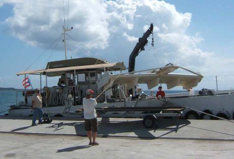
 Easily customizable (nice flat wooden deck) Sufficient towing power (140 HP")
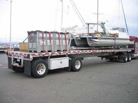
3 Surface Vessel Required stability (triple float pontoon) Adequate length and deck area(30 by 8.5 ft) Easily customizable (nice flat wooden deck) Sufficient towing power (140 HP O/B)


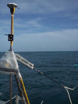
4 Sensor Platform Various considerations Towed sled design Rigidly fixed sensors on a single platform Towed platform with an above water GPS antenna Submerged platform towed with either a rigid boom or flexible tow cable


 Diagnostic data recorded with")
5 Sensor Platform Integrated Cs Mags and TD EM Stern planes controlled by rotary actuators Sensor interface pressure vessel for ancillary electronics (IMU, temp, comms, CPU diagnostics, depth, mag compass) Diagnostic data recorded with sensor data
 and signals(14 TSPs, RS-422) Safety weak link in case of platform snags Specially designed tow point with tow cable angle encoder, interface, and primary GPS")
6 Tow Cable Two different tow lengths(16 & 22 m) to facilitate different depth requirements Integral Kevlar strain member (WL=500 kg) Capable of carrying power(28 Vdc/20A) and signals(14 TSPs, RS-422) Safety weak link in case of platform snags Specially designed tow point with tow cable angle encoder, interface, and primary GPS antenna


7 GPS and Navigation Real Time Kinematic (RTK, 1 cm) Dual antennae for accurate boat heading 10 Hz Fixed RTK positional data output rate Land based stationary RTK base stn with 900 MHz FHSS wireless communication Real time navigation system showing vessel, tow cable angle and platform positions with left/ right steering indication
 DVD+RW (8x) 8 Port RS-232, 8 Port RS-422 PCI cards")
8 Data Acquisition Hardware 4U rackmount Pentium Core 2 Duo 1.6 GHz Dual 160 GB, 7200 RPM SATA RAID 32 MB AGP video card CD-RW drive (40x/24x) DVD+RW (8x) 8 Port RS-232, 8 Port RS-422 PCI cards GPS PCI timing card 15 LCD panel with rackmount keyboard and thumbmouse
9 Platform Autopilot Platform depth and attitude controlled by two rear control fins Control fins positioned by rotary actuators Actuators positions commanded by autopilot software at 15x per second Autopilot software utilizes inputs from IMU, depth pressure transducer, platform sonar altimeter, platform magnetic compass and topside GPS derived velocity Altitude control mode, depth control mode and emergency rise mode

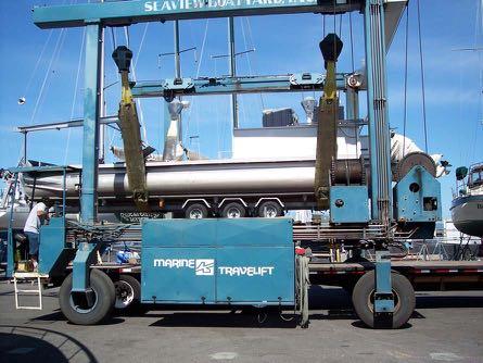
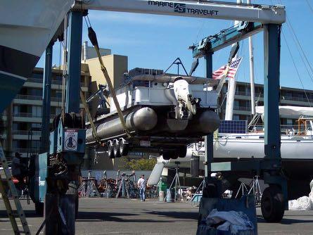
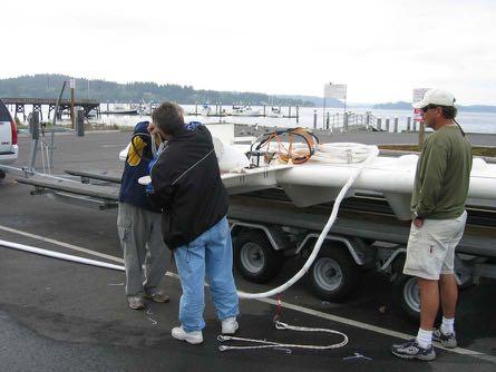
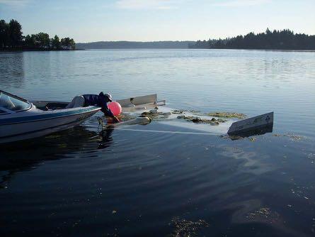
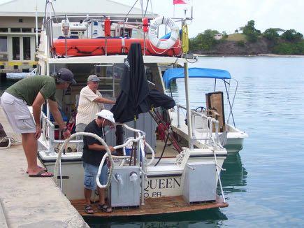
10 Ostrich Bay, Washington State Mobilization/Demobilization Operational Logistics Data Analysis

11 Erie Army Depot, Port Clinton, OH Army proof-tested gun barrels and projectiles for 50 years. Northward firing direction into Lake Erie, no defined bullseye. Survey area ranged from 1 m to 10 m deep. Multiple reefs coming up to within a couple of meters of the surface. Some survey lines over 10 miles from shore.


12 Erie Army Depot, Port Clinton, OH Weather conditions, wind, rain, and waves. Long distance for RTK communications link. Long ferry times, up to ~2 hours. Shallow reefs. Low flying traffic. Investigations


13 Erie Army Depot, Port Clinton, OH Data Collection Transects Data Analysis Dig list Est.>400K Target Retrieval 225 targets


14 Vieques Island, Puerto Rico Mob/Demob Survey Logistics Onsite Repairs Bathymetry Sea States


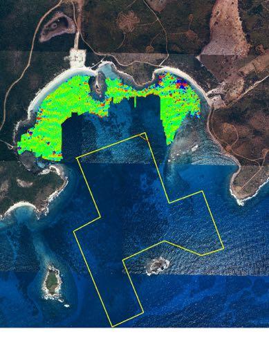
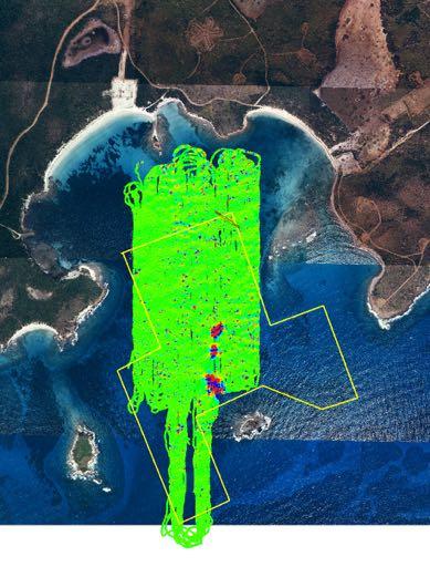
15 Vieques Island, Puerto Rico Data Collection Shallow Areas Deeper Areas Total Coverage

16 Current Projects Deep Water Munitions Detection System Navigational Fish consisting of SS Sonar, INS, DVL, Video, depth sensor & GPS. Sensor Fish housing 3 Cesium mags, sonar altimeter, P&R sensors. 100 feet operational depth.

17 Current Projects Shallow Water UXO Retrieval System No divers required for UXO retrieval. Remotely controlled and operated. Video confirmation of UXO type. 15 feet operational depth.


18 A View From Below Thank You, Questions?
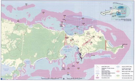
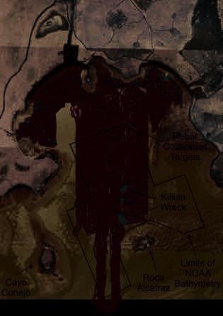
Vieques Underwater Demonstration Project
 Vieques Underwater Demonstration Project NOAA Office of Response and Restoration National Ocean Service 2006-2007 2007 University of New Hampshire Joint Hydrographic Center 2006 Science Application International
ScanFish Katria. Intelligent wide-sweep ROTV for magnetometer surveys
 ScanFish Katria Intelligent wide-sweep ROTV for magnetometer surveys User-friendly control and monitoring software solution The ScanFish Katria comes with the ScanFish III Flight software, which is an
Sontek RiverSurveyor Test Plan Prepared by David S. Mueller, OSW February 20, 2004
 Sontek RiverSurveyor Test Plan Prepared by David S. Mueller, OSW February 20, 2004 INTRODUCTION Sontek/YSI has introduced new firmware and software for their RiverSurveyor product line. Firmware changes
NOAA s Underwater UXO Demonstration Projects Vieques Island, Puerto Rico
 NOAA s Underwater UXO Demonstration Projects Vieques Island, Puerto Rico Vieques Restoration Advisory Board Meeting May 7, 2008 Jason Rolfe NOAA s Office of Response & Restoration NOAA s Underwater UXO
 Side 1 av 7 Home > Diving Equipment > Side Scan Sonar > Imagenex Sidescan Sonar > Yellowfin Yellowfin Sidescan Sonar Magnetometers Side Scan Sonar Cameras Storm Cases Interferometric & Sidescan Equipment
Sensing Odour Sources in Indoor Environments Without a Constant Airflow by a Mobile Robot
 Sensing Odour Sources in Indoor Environments Without a Constant Airflow by a Mobile Robot Achim Lilienthal University of Tübingen WSI Computer Science Dept. http://www-ra.informatik.uni-tuebingen.de Contents
WMB-160F Multi-beam Fishing System
 WMB-160F Multi-beam Fishing System Take away the guess work and see what s REALLY below your boat! Seven Systems in One 2 WMB-160F WMB-160F Screen Shots The WMB-160F is a multi-beam sonar that has been
PropaGator Autonomous Surface Vehicle
 PropaGator Autonomous Surface Vehicle Andrew Wegener December 4, 2012 University of Florida Department of Electrical and Computer Engineering EEL 5666C IMDL Final Report Instructors: A. Antonio Arroyo,
MISSION PLANNING AND DATA ACQUISITION SOFTWARE
 MISSION PLANNING AND DATA ACQUISITION SOFTWARE INTENTIONALLY BLANK Introduction to Divelog Shark Marine s Divelog software was created to integrate data collected from an array of sensors, real-time with
INTRODUCTION TO NETWORK WIND 3 MOUNTING THE UNIT 14 SELECTING THE DISPLAY MODE 5 ABBREVIATIONS AND DEFINITIONS 17
 CONTENTS CONTENTS 1 INSTALLATION 14 GENERAL INTRODUCTION TO B&G NETWORK 2 SITING THE UNIT 14 INTRODUCTION TO NETWORK WIND 3 MOUNTING THE UNIT 14 EXAMPLE SYSTEMS USING NETWORK WIND 4 SPECIFICATION 16 SELECTING
Saab Seaeye Cougar XT Compact
 The Seaeye Cougar-XT Compact is a highly flexible and extremely powerful electric ROV with working depths of 300 metres. This system comes with almost all of the specifications of the very reliable Couger-XT
Sonar Bathymetry: Waquoit Bay NERR
 Sonar Bathymetry: Waquoit Bay NERR Determining the Functional Shallow Water Limitation for an Arrival Based Sonar Frederick A. Hegg Teledyne Benthos, Inc. 49 Edgerton Drive North Falmouth, MA 02556 fhegg@teledyne.com
The Baltic Diver ROV-Services
 The Baltic Diver ROV-Services Comanche ROV The Baltic Diver Comanche ROV is the ideal choice when seeking a Work Class Solution in a small package. Baltic Taucherei- und Bergungsbetrieb Rostock GmbH Main
RAMSTM. 360 Riser and Anchor-Chain Integrity Monitoring for FPSOs
 RAMS 360 Riser and Anchor-Chain Integrity Monitoring for FPSOs Introduction to RAMS Tritech s RAMS is a 360 anchor-chain and riser integrity monitoring system for Floating Production Storage and Offloading
STOPPING THE UNDERWATER DIVER THREAT
 STOPPING THE UNDERWATER DIVER THREAT Dr. Robert F. De La Croix and Mr. Juergen G. Keil A non-lethal, scalable deterrent solution Updated from original article published in Maritime Technology Reporter,
Release Performance Notes TN WBMS _R _Release_Presentation.pptx 22 September, 2014
 TN-140079-1.2 WBMS _R2014-06_Release_Presentation.pptx 22 September, 2014 Since the 2013-12 release, NORBIT has made tremendous improvements to both the functionality and performance of the WBMS systems.
ROV Development ROV Function. ROV Crew Navigation IRATECH SUB SYSTEMS 2010
 IR AT EC H SU B SY ST EM S 20 10 Remotely Operated Vehicle ROV INTRODUCTORY 2008 2008 1 KEY POINTS ROV Introductory ROV Development ROV Function Types of ROV ROV Crew Navigation ROV Components 2 ROV Development
REPORT DOCUMENTATION PAGE
 REPORT DOCUMENTATION PAGE Form Approved OMB No. 0704-0188 Public reporting burden for this collection of information is estimated to average 1 hour per response, including the time for reviewing instructions,
SEAEYE FALCON & FALCON DR
 SEAEYE FALCON & FALCON DR SEAEYE FALCON & FALCON DR The Seaeye Falcon and Falcon DR are the choice of many leading operators for capability, versatility and the ability to get the job done. Lightweight
Simrad yachting catalog 2007
 26 AUTOSTEERING Electronic intelligence combined with powerful and reliable designs make sure you enjoy boating even more. 27 Tillerpilots Enjoy silence when sailing SIMRAD TP SERIES REMOTE COMMANDER High
An Integrated Marine Gradiometer Array System (MGA)
") An Integrated Marine Gradiometer Array System (MGA) For Detection and Location of Chemical and Conventional UXO/MEC in Shallow to Deep Marine and Freshwater Environments Introduction Tetra Tech EC, Inc.
An Integrated Marine Gradiometer Array System (MGA) For Detection and Location of Chemical and Conventional UXO/MEC in Shallow to Deep Marine and Freshwater Environments Introduction Tetra Tech EC, Inc.
Recommended operating guidelines (ROG) for sidescan Sidescan sonar ROG in wrapper.doc English Number of pages: 9 Summary:
 for sidescan Sidescan sonar ROG in wrapper.doc English Number of pages: 9 Summary:") Title: Author(s): Document owner: Recommended operating guidelines (ROG) for sidescan sonar Dave Long (BGS) Dave Long (BGS) Reviewed by: Janine Guinan (MI) 07/09/07 Workgroup: MESH action: 2.1 Version:
Title: Author(s): Document owner: Recommended operating guidelines (ROG) for sidescan sonar Dave Long (BGS) Dave Long (BGS) Reviewed by: Janine Guinan (MI) 07/09/07 Workgroup: MESH action: 2.1 Version:
PART 5 - OPTIONS CONTENTS 5.1 SYSTEM EXPANSION 5-3
 PART 5 - OPTIONS CONTENTS Para Page 5.1 SYSTEM EXPANSION 5-3 5.2 SENSORS 5-3 5.2.1 Trim Angle Sensor 5-3 5.2.2 Mast Rotation Sensor 5-3 5.2.3 Heel Angle Sensor 5-3 5.2.4 Barometric Pressure Sensor 5-3
The MEDUSA Deep Sea and FUSION AUVs:
 1 The MEDUSA Deep Sea and FUSION AUVs: When Research and business get together EMRA 2017, Girona, Spain 15 May 2017 Bruno Cardeira/IST Deep Ocean Exploration -Why the effort? Portugal Exclusive Economic
DUALEM EM EQUIPMENT. Geostudi Astier srl Via Nicolodi, Livorno Italy
 DUALEM EM EQUIPMENT DUALEM instruments (e.g. the DUALEM-1) incorporate a DUALEM sensor as well as an internal WAAS-enabled GPS receiver, a hand-held weatherproof display/keypad/power-supply, a carrying
NUI Overview. Mike Jakuba Woods Hole Oceanographic Institution
 NUI Overview Mike Jakuba Woods Hole Oceanographic Institution Optics Co-Registered Multibeam Fluorometry C. Katlein (AWI) Katlein et. Al, 2015, JGR Still-Camera S. Laney (WHOI) H.Singh (WHOI) 2.5m NUI
Specifications for the CMI 2409 Magnetocardiograph
 Specifications for the CMI 2409 Magnetocardiograph Revision date April 14, 2006 1 518-381-1000 (tel) The CMI-2409 system consists of a holder (A), a patient bed (B) and a workstation (not shown in the
Specifications for Synchronized Sensor Pipe Condition Assessment (AS PROVIDED BY REDZONE ROBOTICS)
") Specifications for Synchronized Sensor Pipe Condition Assessment (AS PROVIDED BY REDZONE ROBOTICS) A. Scope of Work The work covered by these specifications consists of furnishing all materials, labor,
Specifications for Synchronized Sensor Pipe Condition Assessment (AS PROVIDED BY REDZONE ROBOTICS) A. Scope of Work The work covered by these specifications consists of furnishing all materials, labor,
Acoustic Pipeline Inspection Mind The Gap
 Acoustic Pipeline Inspection Mind The Gap Mike Liddell Chief Surveyor, Fugro Survey Limited UUVS @ Oceanology 2012 13 th March 2012 Contents Menu Introduction to Pipeline Inspection The Current Toolkit
Meeting the Challenges of the IHO and LINZ Special Order Object Detection Requirements
 Meeting the Challenges of the IHO and LINZ Special Order Object Detection Requirements Erik Hammerstad Kongsberg Maritime P. O. Box 111, N-3191 Horten, Norway erik.oscar.hammerstad@kongsberg.com Abstract
ATON System Workshop
 ATON System Workshop ATON System: Real-time current measurements from Coast Guard navigation buoys in ports, bays and the coastal ocean Aid-to-Navigation = ATON ATON System Workshop Outline: Overview of
Heavy Duty Dissolved Oxygen Meter
 User's Manual Heavy Duty Dissolved Oxygen Meter Model 407510 Test Equipment Depot - 800.517.8431-99 Washington Street Melrose, MA 02176 FAX 781.665.0780 - TestEquipmentDepot.com Introduction Congratulations
Utilizing Vessel Based Mobile LiDAR & Bathymetry Survey Techniques for Survey of Four Southern California Breakwaters
 Utilizing Vessel Based Mobile LiDAR & Bathymetry Survey Techniques for Survey of Four Southern California Breakwaters Western Dredging Association: Pacific Chapter September 2012 Insert: Pipe Location
Seaeye Falcon powerful portable versatile
 Seaeye Falcon 12170 powerful portable versatile The powerful, portable and versatile Seaeye Falcon designed for coastal and inshore operations to 300 metres water depth or for fly away operations offshore.
The HumiSys. RH Generator. Operation. Applications. Designed, built, and supported by InstruQuest Inc.
 The HumiSys RH Generator Designed, built, and supported by InstruQuest Inc. Versatile Relative Humidity Generation and Multi-Sensor System The new HumiSys with single or dual RH probes capabilities is
Hydrographic Surveying Methods, Applications and Uses
 Definition: Hydrographic Surveying Methods, Applications and Uses It is the branch of surveying which deals with any body of still or running water such as a lake, harbor, stream or river. Hydrographic
05 Boat Handling. Captain
 05 Boat Handling Competence (Skills) Knowledge, Understanding and Proficiency Level Required Boat handling theory and techniques Coxswain Crew RQ RQ Describe the forces acting on a vessel while manoeuvering
USER S GUIDE DepthTrax 1H HawkEye Portable Depth Finder (DT1H)
") USER S GUIDE DepthTrax 1H HawkEye Portable Depth Finder (DT1H) Thank you for purchasing a HawkEye product, and welcome to the innovations of NorCross Marine Products, Inc. To ensure safety and many years
USER S GUIDE DepthTrax 1H HawkEye Portable Depth Finder (DT1H) Thank you for purchasing a HawkEye product, and welcome to the innovations of NorCross Marine Products, Inc. To ensure safety and many years
Location: Barkley Canyon Date: September 9, 2013 Constraints: none
 Page 1 of 11 DIVE PLAN R1650 Location: Barkley Canyon Date: September 9, 2013 Constraints: none Objectives Deploy POD 1 autonomous CTD Survey POD 3 for sediment enrichment sites; deposit cages; collect
Completion of Hydrometric Survey Notes (HSN)
") Completion of Hydrometric Survey Notes (HSN) Hydrometric Survey Notes provide a place to record results and applied proper procedures for tasks undertaken in the field, such as levelling, measurements,
Completion of Hydrometric Survey Notes (HSN) Hydrometric Survey Notes provide a place to record results and applied proper procedures for tasks undertaken in the field, such as levelling, measurements,
CONSTRUCTION OF LNG RECEIVING TERMINAL ON THE SAINT LAWRENCE TIDAL CURRENT CONDITIONS IN THE LEVIS AREA
 RABASKA PROJECT CONSTRUCTION OF LNG RECEIVING TERMINAL ON THE SAINT LAWRENCE TIDAL CURRENT CONDITIONS IN THE LEVIS AREA FINAL REPORT MARCH 2006 N/Réf. : 24237.360 3075, ch. des Quatre-Bourgeois Sainte-Foy
Response Boat & Barge
 Response Boat & Barge Oil Spill Equipment Floating Barriers Incinerators ELASTEC INLANDER BOAT & BARGE Work Horse of the Waterways With the speed of a thoroughbred and the strength of a draft horse, the
USCGC HEALY WAGB-20 Final Report RD Instruments Inc. Ocean Surveyor 75 khz Prepared by: Ron Hippe Commissioning Dates: 3/27/2002-3/30/2002
 USCGC HEALY WAGB-20 Final Report Inc. Ocean Surveyor 75 khz Prepared by: Ron Hippe Commissioning Dates: 3/27/2002-3/30/2002 This report outlines the tests performed, and the results of Harbor and Sea testing
SWS Option: Well Pressures. SWS Option: Stretch Correction (Corrected depth) SWS Option: MMD (Magnetic Marks Detection) ASEP Products
 SWS Option: MMD (Magnetic Marks Detection) ASEP Products") SWS Option: Well Pressures PART NUMBER L-8531039779 The SmartMonitor can simultaneously measure, display and record depth and up to four different well pressures (for example, Control Line Pressure, Tubing
SWS Option: Well Pressures PART NUMBER L-8531039779 The SmartMonitor can simultaneously measure, display and record depth and up to four different well pressures (for example, Control Line Pressure, Tubing
Robin J. Beaman. School of Earth and Environmental Sciences, James Cook University, Cairns, Qld 4870, Australia.
 Robin J. Beaman School of Earth and Environmental Sciences, James Cook University, Cairns, Qld 4870, Australia. Email: robin.beaman@jcu.edu.au Seminar to SSSI Qld Hydrography Coping with Nature, Brisbane,
NAUTICAL TERMINOLOGY
 It s important to have a basic understanding of common nautical terms associated with the parts, positions and directions of your vessel. Knowing these terms will make it easier to communicate with people
8. Tracking, Marking and Locating. 8. Tracking, Marking & Locating your FTTx Network
 8. Tracking, Marking & Locating your FTTx Network Single Family Units Outside Plant: Aerial Fibre Pedestal Outside Plant: Buried Fibre 3M Telecommunications provides you with solutions to distribute your
Data Collection and Processing: Elwha Estuary Survey, February 2013
 Data Collection and Processing: Elwha Estuary Survey, February 2013 Ian Miller, WA Sea Grant Olympic Peninsula Field Office, 1502 E. Lauridsen Blvd #82, Port Angeles, WA 98362 immiller@u.washington.edu
Sparse LBL aided INS for Subsea Positioning
 Sparse LBL aided INS for Subsea Positioning Edward Moller Global Business Manager Construction Survey What is LBL? GPS Network What is LBL? We turn GPS upside down LBL installed in a subsea field development
Code Basic module and level control complete with optionals code
 AUTOMATION AND PROCESS CONTROL MPCT - Modular Process Control Trainer Code 916960 Basic module and level control complete with optionals code 916961-916962-916963-916964-916965 1. General Didacta proposes
CoastaZ Engineering. Technical Note AIRBORNE COASTAL CURRENT EVALUATION SURVEY SYSTEM
 CETN VI-25 (Dee 92) CoastaZ Engineering Technical Note AIRBORNE COASTAL CURRENT EVALUATION SURVEY SYSTEM PURPOSE: This Technical Note introduces a new method for collecting current measurements at multiple
Survey design and acquisition of a 4-C ocean-bottom seismometer survey over the White Rose oilfield, offshore Newfoundland
 White Rose OBS, 2002 Survey design and acquisition of a 4-C ocean-bottom seismometer survey over the White Rose oilfield, offshore Newfoundland Kevin W. Hall and Robert R. Stewart ABSTRACT CREWES, in conjunction
The Evolution of an Autonomous Unmanned Surface Vessel and Software for Hydrographic Survey
 The Evolution of an Autonomous Unmanned Surface Vessel and Software for Hydrographic Survey Paul Donaldson In 2017, Leidos, Inc. participated in both the Gulf of Mexico Unmanned Systems Operational Demonstration
SeaBat T50-R Product Description
 Ultra-High Resolution Multibeam Echosounder March 2017 PD17419-3 Table of Contents SYSTEM OVERVIEW... 5 Introduction... 5 Typical Applications... 5 Warranty... 5 SYSTEM ARCHITECTURE... 6 SeaBat T50-R...
BACKGROUND TO STUDY CASE
 BACKGROUND TO STUDY CASE German Aerospace Center (DLR) is using Andøya Rocket Range for a sounding rocket campaign. On 27th October 2005 a 300 kg payload (SHEFEX) was launched Due do a technical problems
SeaSmart. Jonathan Evans
 SeaSmart A new approach for rapid, on-site resource assessment at potential tidal stream energy array sites using MAS Marine Solutions for the Deep Data World Jonathan Evans Presentation Outline Marine
HOW TO BEST USE YOUR ELECTRONICS: CHARTING, SONAR, AND IMAGING. By: Captain Tom Blackburn
 HOW TO BEST USE YOUR ELECTRONICS: CHARTING, SONAR, AND IMAGING By: Captain Tom Blackburn Topics I. INTRODUCTION II. CHARTING A TREMENDOUS FISH FINDING TOOL III. CHARTING - SIGNIFICANT CHARTING AND NAVIGATIONAL
Trim and Stabilisation systems NEXT GENERATION IN BOAT CONTROL.
 Trim and Stabilisation systems NEXT GENERATION IN BOAT CONTROL www.humphree.com WHEN EFFICIENCY AND PERFORMANCE REALLY MATTERS! Humphree proudly presents the new HCS-5 The HCS-5 combines exceptional mechanical
AUTOMATIC DREDGING PROFILE AND CONTOUR CONTROL
 AUTOMATIC DREDGING PROFILE AND CONTOUR CONTROL Jay Wise 1 ABSTRACT Phillips and Jordan, a leading excavating and disaster recovery contractor, was faced with the challenge to manage a civil contract involving
FINAL REPORT DERELICT FISHING GEAR IDENTIFICATION AND REMOVAL PROJECT PORT SUSAN
 1900 W. NICKERSON, STE. 207 SEATTLE, WASHINGTON 98119-1650, U.S.A. TELEPHONE: (206) 285-3480 TELEFAX: (206) 283-8263 E-Mail : jjune@nrccorp.com (corporate) FINAL REPORT DERELICT FISHING GEAR IDENTIFICATION
Sentry de-brief summaries 2011/2012
 Three cruises*: 1 Sentry/TowCam 1 Sentry/TowMag 1 Sentry/Jason *All cruises were post-refit 1 Pre-Cruise Planning: For two cruises everything was fine and went well For 1 cruise - planning began just one
780S Ultra High Purity Series
 Smart Ultra High Purity Thermal Gas Mass Flow Meter Features Measures mass flow directly, no seperate temperature or pressure inputs required Field adjustment of critical flow meter settings via on-board
frequently asked questions
 Hydra Pilot Fault Codes What do the fault codes for the Hydra Pilot mean? Fault Cause FAULT 100 FAULT 101 FAULT 102 FAULT 103 FAULT 104 FAULT 105 FAULT 106 FAULT 108 FAULT 109 FAULT 110 FAULT 111 FAULT
The Wave Glider: A Mobile Buoy Concept for Ocean Science. 009 Liquid Robotics Inc.
 The Wave Glider: A Mobile Buoy Concept for Ocean Science 009 Liquid Robotics Inc. J. Manley & T. Richardson: Liquid Robotics Inc. DBCP XXV Paris September 28, 2009 1 Wave Glider Overview Unique Two Part
Actual Size. WX Series Ultrasonic WeatherStation Instruments
 fpo www.busse-yachtshop.de info@busse-yachtshop.de Actual Size WX Series Ultrasonic WeatherStation Instruments AIRMAR s best-in-class, all-in-one solution for real-time, site-specific weather information
WAVE IMPACTS DUE TO STEEP FRONTED WAVES
 WAVE IMPACTS DUE TO STEEP FRONTED WAVES Bas Buchner and Arjan Voogt Maritime Research Institute Netherlands (MARIN) b.buchner@marin.nl, a.j.voogt@marin.nl INTRODUCTION It is the question whether Rogue
MOTUS Wave Buoys. Powered By the Aanderaa MOTUS Directional Wave Sensor
 MOTUS Wave Buoys Powered By the Aanderaa MOTUS Directional Wave Sensor Two Buoys, One Brain The Aanderaa MOTUS directional wave sensor factory calibrated and currently available on two proven buoy platforms:
Coastal Engineering Technical Note
 CETN VI-25 (Dec 92) Coastal Engineering Technical Note AIRBORNE COASTAL CURRENT EVALUATION SURVEY SYSTEM PURPOSE: This Technical Note introduces a new method for collecting current measurements at multiple
Sorensen DCS Series. 1 3 kw V A. General Purpose Systems Power Supply
 Sensen DCS Series General Purpose Systems Power Supply High power density / low ripple and noise High programming resolution with Ethernet interface Constant voltage and current mode Remote sensing Isolated
Smart Data Role computers play in Technology
 Smart Data Role computers play in Technology October 30 th 2015 Sizzle Video 2016 2 Introduction: Will Phillips INDYCAR Vice President of Technology Daniel Louks INDYCAR Support Engineer Smart Data Role
NEW! for 2015 NAVIGATION & PERFORMANCE ENHANCEMENTS DPD DIVER PROPULSION DEVICE SOF USERS OF STIDD SUB BOATS.
 DPD DIVER PROPULSION DEVICE for 2015 NAVIGATION & PERFORMANCE ENHANCEMENTS SOF USERS OF STIDD SUB BOATS www.stiddmil.com We Built The Best Combat Diver Vehicle ever... and then Made it Better Navigation
Hydro. Tab Marine Engineering. Interceptor Trim Tabs. Born to live in the sea. 2017ver.1
 Hydro Tab Interceptor Trim Tabs Born to live in the sea 2017ver.1 Designed to operate... Developed under NMEA 2000 protocol Compatible with NMEA 018 Hydrotab is an innovative patented trim system designed
Cathodic Protection Retrofit Options Comparison of Current Distribution
 Cathodic Protection Retrofit Options Comparison of Current Distribution 1.0 Introduction There are three basic methods available for the deployment of anode systems when considering an offshore cathodic
Shallow Water Bathymetry using the REMUS 100 Autonomous Underwater Vehicle
 Shallow Water Bathymetry using the REMUS 100 Autonomous Underwater Vehicle Michael Bell Maritime Division Defence Science and Technology Organisation DSTO-TR-2916 ABSTRACT This report describes assessments
TransPort PT878GC Panametrics Ultrasonic Portable Gas Flowmeter. GE Infrastructure Sensing. Features. Applications
 Applications The TransPort PT878GC clamp-on gas flowmeter is a complete ultrasonic flow metering system for measurement of most gases, including: Natural gas Compressed air Fuel gases Erosive gases Corrosive
RESULTS FROM PARACHUTE SEA ANCHOR DRAG TESTS FOR A SPACE CAPSULE, Jan. 10, 2013
 FIORENTINO Technical Report FPA-152 Report Prepared for: America s next generation of spacecraft A spacecraft can be a diameter of 16.5-foot and weigh 18,000 lbs. at splashdown. When the parachute sea
Department. «Ships and on-board Equipment» lfremer. (Head : Marc Nokin)
") Department «Ships and on-board Equipment» (Head : Marc Nokin) 1 Structuration and activities of NSE department Scope Construction and modernisation of Ifremer oceanographic ships Development of softwares
Department «Ships and on-board Equipment» (Head : Marc Nokin) 1 Structuration and activities of NSE department Scope Construction and modernisation of Ifremer oceanographic ships Development of softwares
Product highlights Variable frequency and thrust
 Innovative engineering for extreme global environments FT550 - VIBROCORER The 3rd generation FT550 lightweight variable frequency high power vibrocorer leads the market in its technical innovation and
BUBBLER CONTROL SYSTEM
 BUBBLER CONTROL SYSTEM Description: The LDBCS is a fully automatic bubbler system, which does liquid level measurements in water and wastewater applications. It is a dual air compressor system with, air
Fault Diagnosis based on Particle Filter - with applications to marine crafts
 1 Fault Diagnosis based on Particle Filter - with applications to marine crafts Bo Zhao CeSOS / Department of Marine Technology Norwegian University of Science and Technology 2 Faults Danger and harm Pollution
CMA4000 Specifications
 CMA4000 Specifications Display Mass Storage VGA LCD Display (8.4 color or 8.2 monochrome) Up to 125 traces internal storage. Over 65,000 traces with optional hard drive. Up to 180 traces for a standard
BUYER S GUIDE AQUAlogger 530WTD
 OCEAN & ENVIRONMENTAL BUYER S GUIDE AQUAlogger 530WTD Wireless Temperature and Depth Logger AQUAlogger 530WTD The AQUAlogger 530WTD has an innovative design that includes the ability to transfer stored
Using Sonar for Navigation
 Using Sonar for Navigation By Steve Dashew We spend a lot of time cruising in remote areas, where charts tend to be out-of-date or nonexistent. For years we've been thinking about using sonar for navigation
GHC 20. Owner s Manual
 GHC 20 Owner s Manual 2013 Garmin Ltd. or its subsidiaries All rights reserved. Under the copyright laws, this manual may not be copied, in whole or in part, without the written consent of Garmin. Garmin
The TRV series has sufficient thrust to allow operations in currents up to 3 knots and down to depths of 3,300. Wolfgang Burnside
 The TRV series has sufficient thrust to allow operations in currents up to 3 knots and down to depths of 3,300 Wolfgang Burnside TRV-005 Series: Standard Features and Benefits Frame The TRV 005 Series
UTEC Survey Pipeline Inspection Using Low Logistic AUV June 2016
 SUCCESS YOU CAN MEASURE UTEC Survey Pipeline Inspection Using Low Logistic AUV June 2016 Chris Erni Product Line Manager E T H I C S P E R F O R M A N C E E X C E L L E N C E P E O P L E GLOBAL FOOTPRINT
2012 INDUSTRY DAY Society of American Military Engineers - Omaha Post
 2012 INDUSTRY DAY Society of American Military Engineers - Omaha Post Omaha District Corps of Engineers Military Munitions Design Center (MMDC) Glenn Marks MMDC Manager May 8, 2012 US Army Corps of Engineers
Compact Light Weight RC Boat for Hydrographic Surveys on Dams, Creeks, Rivers, storm water retention pits and other waterways.
 Accura Hydrographic RC Survey Boat Compact Light Weight RC Boat for Hydrographic Surveys on Dams, Creeks, Rivers, storm water retention pits and other waterways. Utilises Sounder & Transducer from CEE
Oxidation Stability of Gasoline and Aviation Fuels
 Oxidation Stability of Gasoline (Induction Period Method) Oxidation Stability of Aviation Fuels (Potential Residue Method) Test Method Provides an indication of the tendency of gasoline and aviation fuels
INSIDE 16. Hydrographic Soundings, Sensors, and Bots. Dual-head Sonar Mapping. 25 A Case for Big Blue Data. Collaboration in the Air & on the Ground
 POSITIONING AND MEASUREMENT, ELEVATED AUGUST 2016 INSIDE: SURVEYING HYDROGRAPHY EDUCATION MAPPING UAS MACHINE CONTROL Hydrographic Soundings, Sensors, and Bots INSIDE 16 25 A Case for Big Blue Data 31
Advantages of Using Combined Bathymetry and Side Scan Data in Survey Processing T.M. Hiller, L.N. Brisson
 Advantages of Using Combined Bathymetry and Side Scan Data in Survey Processing T.M. Hiller, L.N. Brisson EdgeTech, West WareHam MA, USA EdgeTech 6205 Combined Bathymetric and Side Scan Sonar EdgeTech
SP-110 Autopilot OPERATION
 SP-110 Autopilot OPERATION www.si-tex.com Warning! WHEN USING THE AUTOPILOT AN ADEQUATE WATCH SHOULD BE MAINTAINED AT ALL TIMES. THE AUTOPILOT MUST BE PLACED IN MANUAL MODE WHEN EVER THE VESSEL IS STATIONARY
SPECIFICATIONS OF FAST PATROL BOATS(FPBs) FOR FLOATING BORDER OUT POSTs(BOPs)
 FOR FLOATING BORDER OUT POSTs(BOPs)") SPECIFICATIONS OF FAST PATROL BOATS(FPBs) FOR FLOATING BORDER OUT POSTs(BOPs) 1. Overview 2. Hull The Patrol Boat (PB) proposed for the BSF Floating BOP has been specifically designed to meet the projected
SPECIFICATIONS OF FAST PATROL BOATS(FPBs) FOR FLOATING BORDER OUT POSTs(BOPs) 1. Overview 2. Hull The Patrol Boat (PB) proposed for the BSF Floating BOP has been specifically designed to meet the projected
Transfer of Autonomous Underwater Vehicle Technology, NIO, Goa
 Expression of interest for Transfer of Autonomous Underwater Vehicle Technology, NIO, Goa CONTENTS No Title Page 1 Technology 2 2 Figures and Photos 3 3 Specifications 3 4 Publications and articles related
APPLICATION NOTE: MARINE APPLICATIONS Trim, Roll and Leeway.
 APPLICATION NOTE: MARINE APPLICATIONS Trim, Roll and Leeway. An Alternative VBOX Application Examples of Trim Angle effects Traditionally, the VBOX has been used by automotive markets but the wealth of
Panel Discussion on unmanned Hydrography
 Panel Discussion on unmanned Hydrography Overview Why bother General Types Autonomous Underwater Vehicle (AUV) Remotely Operated Vehicle (ROV) Unmanned Surface Vessels (USV) TerraSond s Experiences AUV
GPS-based Vertical Control, Unaided by a Shore Station
 GPS-based Vertical Control, Unaided by a Shore Station John Shannon Byrne, SAIC, Newport, R.I. Gail Smith, NAVOCEANO, Stennis Space Center, Miss. Walter Simmons, SAIC, Newport, R.I. Bill Mehaffey, NAVOCEANO,
BUBBLER CONTROL SYSTEM
 BUBBLER CONTROL SYSTEM Description: The HDBCS is a fully automatic bubbler system, which does liquid level measurements in water and wastewater applications. It is a dual air compressor system with, air
Sail Racing Instruments. Aspect 40
 Sail Racing Instruments www.nexusmarine.se Presentation Nexus Marine is a leading manufacturer of navigation instrumentation for racing and cruising yachts. Nexus brings with it seventy years of experience
Pneumatic high-pressure controller Model CPC7000
 Calibration technology Pneumatic high-pressure controller Model CPC7000 WIKA data sheet CT 27.63 Applications Healthcare and avionics industry Industry (laboratory, workshop and production) Transmitter