|
|
|
- Dustin Russell
- 5 years ago
- Views:
Transcription
1
2
3
4
5
6
7
8 ON SHIPS OF 200 GRT/500 GT OR MORE Assessment Sheets Enclosure (1) to CG-543 Policy Letter 11-07
9 ASSESSMENT NO. OICNW-1-1A COMPETENCE: Plan and conduct a passage and determine position KNOWLEDGE, UNDERSTANDING & PROFICIENCY: Celestial Navigation -- Ability to use celestial bodies to determine the ship s position. TASK: Adjust a sextant PERFORMANCE CONDITION: On a ship underway, given a standard marine sextant with a perpendicularity error, side error, parallelism error, and collimation error, totaling no more than 2 and a clear horizon or sharply defined cloud. PERFORMANCE BEHAVIOR: Remove the adjustable sextant errors 1. The errors are removed in the following order: a. Perpendicularity; b. Side error; c. Parallelism; and d. Collimation error. 2. The index error is less than 0.5 minutes of arc as determined by the assessor. s Mariner
10 ASSESSMENT NO. OICNW-1-1B COMPETENCE: Plan and conduct a passage and determine position KNOWLEDGE, UNDERSTANDING & PROFICIENCY: Celestial Navigation -- Ability to use celestial bodies to determine the ship s position TASK: Measure the altitude of the sun PERFORMANCE CONDITION: Aboard a ship at sea, given a standard marine sextant, a clear horizon, a visible sun, and an accurate time. PERFORMANCE BEHAVIOR: Measure the altitude of the lower limb of the sun and accurately record the time of the observation. 1. The altitude is within ±0.5 minutes of arc, after correction for index error, as compared with the altitude measured by the assessor at the same time; and, 2. The time is within ± 2 second of UTC at the time of observation as determined by the assessor. s Mariner
11 ASSESSMENT NO. OICNW-1-1C COMPETENCE: Plan and conduct a passage and determine position KNOWLEDGE, UNDERSTANDING & PROFICIENCY: Celestial Navigation -- Ability to use celestial bodies to determine the ship s position TASK: Measure the altitude of at least 3 stars PERFORMANCE CONDITION: Aboard a ship at sea, given a standard marine sextant, a clear horizon, a clear or partly cloudy sky, and an accurate time, during a single twilight. PERFORMANCE BEHAVIOR: Measure the altitude of three stars and accurately record the times of the observation of each star. 1. The altitude is within ±0.5 minutes of arc, after correction for index error, compared with the assessor s solution; and, 2. The time is within ± 2 seconds of UTC of the assessor s solution. s Mariner
12 ASSESSMENT NO. OICNW-1-1D COMPETENCE: Plan and conduct a passage and determine position KNOWLEDGE, UNDERSTANDING & PROFICIENCY: Celestial Navigation -- Ability to use celestial bodies to determine the ship s position TASK: Measure the altitude of the sun at meridian passage (local apparent noon) PERFORMANCE CONDITION: Aboard a ship at sea, given a standard marine sextant, a clear horizon, a clear or partly cloudy sky. PERFORMANCE BEHAVIOR: Measure the altitude of the sun as it transits the meridian on which the vessel is located. The altitude is within ±0.5 minutes of arc, after correction for index error, of the assessor s solution measured at meridian passage. s Mariner
13 ASSESSMENT NO. OICNW-1-1E COMPETENCE: Plan and conduct a passage and determine position KNOWLEDGE, UNDERSTANDING & PROFICIENCY: Celestial Navigation -- Ability to use celestial bodies to determine the ship s position TASK: Celestial running fix PERFORMANCE CONDITION: Aboard a ship at sea, or in a navigation laboratory, when given the assumed positions, the intercepts, azimuths, times of three observations of the sun, and a standard plotting sheet appropriate for the dead reckoning position. PERFORMANCE BEHAVIOR: Advance all three lines of position to a common time. The position of the running fix is within 1 nm of the assessor s solution. s Mariner
14 ASSESSMENT NO. OICNW-1-1F COMPETENCE: Plan and conduct a passage and determine position KNOWLEDGE, UNDERSTANDING & PROFICIENCY: Celestial Navigation -- Ability to use celestial bodies to determine the ship s position TASK: Star fix PERFORMANCE CONDITION: Aboard a ship at sea, or in a navigation laboratory, when given the assumed positions, the intercepts, azimuths, and times of three star observations, and on a standard plotting sheet appropriate for the dead reckoning position. PERFORMANCE BEHAVIOR: Plot the three lines of position and advance them to a common time. The position of the star fix is within 1 nm of the assessor s solution. s Mariner
15 ASSESSMENT NO. OICNW-1-2A COMPETENCE: Plan and conduct a passage and determine position KNOWLEDGE, UNDERSTANDING & PROFICIENCY: Terrestrial and Coastal Navigation -- Ability to determine the ship s position by use of: landmarks; and, aids to navigation, including lighthouses, beacons and buoys TASK: Fix by two bearings PERFORMANCE CONDITION: On a ship underway, or a full mission ship simulator, with land and aids to navigation in sight, using a standard bearing circle, alidade, or other device for taking bearings, and given a chart with a scale of no more than 1: 150,000. PERFORMANCE BEHAVIOR: Determine the bearings of at least two charted objects and plot them. 1. The position is within ±.1 nm of the assessor s solution; 2. Crossing angles of bearings should be not less than 30 and not more than 160 between bearings; 3. The bearings of objects abeam or close to the beam are observed first; and 4. The chart in use is the largest scale suitable for the waters being transited. s Mariner
16 ASSESSMENT NO. OICNW-1-2B COMPETENCE: Plan and conduct a passage and determine position KNOWLEDGE, UNDERSTANDING & PROFICIENCY: Terrestrial and Coastal Navigation -- Ability to determine the ship s position by use of: Marine Radar TASK: Fix by two ranges PERFORMANCE CONDITION: On an operational marine radar or a radar simulator that meets applicable national and international performance standards, with land and buoys displayed, and given a chart with a scale of no more than 1: 150,000. PERFORMANCE BEHAVIOR: Determine two or more ranges measured from identified charted objects or points of land and plot them. The position is within ±.1 nm of the assessor s solution. s Mariner
17 ASSESSMENT NO. OICNW-1-2C COMPETENCE: Plan and conduct a passage and determine position KNOWLEDGE, UNDERSTANDING & PROFICIENCY: Terrestrial and Coastal Navigation -- Ability to determine the ship s position by use of: Marine Radar TASK: Fix by tangents to two identified objects PERFORMANCE CONDITION: On an operational marine radar or a radar simulator that meets applicable national and international performance standards, with land and buoys displayed, and given a chart with a scale of no more than 1: 150,000. PERFORMANCE BEHAVIOR: Determine two or more tangents measured from identifiedcharted objects or points of land and plot them. The position is within ±.1 nm of the assessor s solution. s Mariner
18 ASSESSMENT NO. OICNW-1-2D COMPETENCE: Plan and conduct a passage and determine position KNOWLEDGE, UNDERSTANDING & PROFICIENCY: Terrestrial and Coastal Navigation -- Ability to determine the ship s position by use of: Dead Reckoning TASK: Plot the ship s DR position PERFORMANCE CONDITION: On a ship underway and using a standard plotting sheet or chart, and given the vessels speed made good and course made good for the past four hours. PERFORMANCE BEHAVIOR: Plot the ship s DR position for every hour (or more frequently if required) for the duration of the watch. The position is within ± 1 nm of the assessor s solution. s Mariner
19 ASSESSMENT NO. OICNW-1-2E COMPETENCE: Plan and conduct a passage and determine position KNOWLEDGE, UNDERSTANDING & PROFICIENCY: Terrestrial and Coastal Navigation -- Ability to determine the ship s position by use of: Set and drift TASK: Determine course to steer PERFORMANCE CONDITION: On a ship underway, or a full mission ship simulator, with the ship s speed of at least 10 knots, and using a plotting sheet or chart, when encountering wind and current which sets the vessel. PERFORMANCE BEHAVIOR: Plot the vessel s position on at least two successive occasions not less than 30 minutes apart, for a vessel steaming at 20 kts, and calculate set and drift by vector analysis and determine the course to steer to make the intended course. The course to steer is within ± 5 of the assessor s solution. s Mariner
20 ASSESSMENT NO. OICNW-1-3A COMPETENCE: Plan and conduct a passage and determine position KNOWLEDGE, UNDERSTANDING & PROFICIENCY: Thorough knowledge of and ability to use navigational charts and publications, such as sailing directions, tide tables, notices to mariners, radio navigational warnings and ship s routing information. TASK: Correction of charts and publications PERFORMANCE CONDITION: On a ship, or in a navigational laboratory, given notices to mariners and uncorrected charts, and publications. PERFORMANCE BEHAVIOR: Correct five charts and three publications, including the Light List or List of Lights. 1. Charts and publications needing correction are identified; 2. Corrections are correctly made to the affected charts and publications; 3. All corrections are recorded on the chart and the chart correction record (or the chart correction spreadsheet); or for publications, on the correction page of the publication, and on the publication correction card or the publication correction spreadsheet. s Mariner
21 ASSESSMENT NO. OICNW-1-3B COMPETENCE: Plan and conduct a passage and determine position KNOWLEDGE, UNDERSTANDING & PROFICIENCY: Thorough knowledge of and ability to use navigational charts and publications, such as sailing directions, tide tables, notices to mariners, radio navigational warnings and ship s routing information TASK: Chart selection PERFORMANCE CONDITION: On a ship, or in a navigational laboratory, given a voyage of at least 1,000 NM between the port of departure and the port of arrival, given the appropriate chart catalog. PERFORMANCE BEHAVIOR: Identify the charts needed for the voyage. 1. The name and number of the charts are correctly identified and recorded. 2. The charts selected are the largest scales appropriate for the area being transited. 3. There is no gap in chart coverage for any portion of the voyage requiring coastal navigation and departure and arrival at any port. s Mariner
22 ASSESSMENT NO. OICNW-1-3C COMPETENCE: Plan and conduct a passage and determine position KNOWLEDGE, UNDERSTANDING & PROFICIENCY: Thorough knowledge of and ability to use navigational charts and publications, such as sailing directions, tide tables, notices to mariners, radio navigational warnings and ship s routing information TASK: Route planning PERFORMANCE CONDITION: On a ship, a full mission ship simulator, or in a navigation laboratory, when given three way points consisting of a position of departure, a position of arrival, and one other way point, with the total distance of more than 1,000 nm. PERFORMANCE BEHAVIOR: Determine the appropriate courses and distances between way points and plot the intended courses on the charts selected. 1. Courses and distances between waypoints were correctly calculated; 2. The route was the most direct; and 3. The courses were plotted on the appropriately scaled charts noting the ETA at each way point, including the final way point. s Mariner
23 ASSESSMENT NO. OICNW-1-4A COMPETENCE: Plan and conduct a passage and determine position KNOWLEDGE, UNDERSTANDING & PROFICIENCY: Electronic systems of position fixing and navigation -- Ability to determine the ship s position by use of electronic navigational aids: GPS TASK: fix by GPS PERFORMANCE CONDITION: On a ship underway, or on a full-mission ship simulator, or in a navigation laboratory, using a GPS or DGPS receiver which meets IMO performance standards. PERFORMANCE BEHAVIOR: Initialize a GPS or DGPS receiver, determine the ship s position and evaluate the accuracy of that position. 1. The system was initialized; and 2. The accuracy of the position was determined. s Mariner
24 ASSESSMENT NO. OICNW-1-4B COMPETENCE: Plan and conduct a passage and determine position KNOWLEDGE, UNDERSTANDING & PROFICIENCY: Electronic systems of position fixing and navigation -- Ability to determine the ship s position by use of electronic navigational aids: GPS TASK: Use of GPS position save function PERFORMANCE CONDITION: On a ship underway, or on a full-mission ship simulator, or in a navigation laboratory, using a GPS or DGPS receiver which meets IMO performance standards, when hearing Man Overboard. PERFORMANCE BEHAVIOR: Activate the man overboard/emergency position save function. The ship s position is saved or recorded within one minute of hearing Man Overboard. s Mariner
25 ASSESSMENT NO. OICNW-1-4D COMPETENCE: Plan and conduct a passage and determine position KNOWLEDGE, UNDERSTANDING & PROFICIENCY: Echo Sounders -- Ability to operate the equipment and apply the information correctly TASK: Use of echo sounder PERFORMANCE CONDITION: On a ship underway using an echo sounder that meets IMO performance standards or a part task trainer that realistically simulates all the functions and controls of an echo sounder that meets IMO performance standards. PERFORMANCE BEHAVIOR: Turn on, test, and operate the echo sounder. 1. The system was turned on; 2. The echo sounder was tested in accordance with manufacturer s recommendations; 3. The correct UTC is noted on the echo sounder paper (if fitted); 4. The scale selected was the lowest appropriate for the vessel s draft and the depth of water of the area of transit; and 5. The sensitivity was adjusted to obtain proper depth reading on the display and correct trace on the paper (if fitted). s Mariner
26 ASSESSMENT NO. OICNW-1-5A COMPETENCE: Plan and conduct a passage and determine position KNOWLEDGE, UNDERSTANDING & PROFICIENCY: Magnetic & Gyro Compass -- Ability to determine errors of the magnetic and gyro-compasses, using terrestrial means, and to allow for such errors TASK: Determine gyro compass error by bearing of range PERFORMANCE CONDITION: On a ship underway or a full mission ship simulator, using navigational or natural terrestrial ranges. PERFORMANCE BEHAVIOR: Take a visual bearing of the range and determine gyrocompass error. 1. The visual bearing is compared to the charted bearing; 2. The compass error is determined and properly labeled; and 3. The solution is ±.5 of the assessor s solution. s Mariner
27 ASSESSMENT NO. OICNW-1-5B COMPETENCE: Plan and conduct a passage and determine position KNOWLEDGE, UNDERSTANDING & PROFICIENCY: Magnetic & Gyro Compass -- Ability to determine errors of the magnetic and gyro-compasses, using terrestrial means, and to allow for such errors TASK: Determine magnetic compass error PERFORMANCE CONDITION: On a ship underway or a full mission ship simulator, with both a magnetic and gyrocompass. PERFORMANCE BEHAVIOR: Determine the magnetic compass error. 1. The magnetic heading is compared to the corrected gyro heading (corrected for a known gyro error); 2. The magnetic compass error is determined and properly labeled; 3. The solution is ±.5 of the assessor s solution; and 4. The error is correctly recorded in the compass record book and the ship s log. s Mariner
28 ASSESSMENT NO. OICNW-1-5C COMPETENCE: Plan and conduct a passage and determine position KNOWLEDGE, UNDERSTANDING & PROFICIENCY: Magnetic & Gyro Compass -- Ability to determine errors of the magnetic and gyro-compasses, using terrestrial means, and to allow for such errors TASK: Determine magnetic compass deviation PERFORMANCE CONDITION: On a ship underway or a full mission ship simulator, using navigational or natural terrestrial ranges, using only a magnetic compass, and a chart with variation. PERFORMANCE BEHAVIOR: Note the vessel's magnetic compass heading while aligned on the range and determine magnetic compass deviation. 1. The magnetic heading is compared to the charted range bearing; 2. The magnetic compass error is determined and properly labeled; 3. Variation is determined from the chart; 4. The deviation solution is ±.5 of the assessor s solution; and 5. The deviation is correctly recorded in the compass record book and the ship s log. s Mariner
29 ASSESSMENT NO. OICNW-1-5D COMPETENCE: Plan and conduct a passage and determine position KNOWLEDGE, UNDERSTANDING & PROFICIENCY: Magnetic & Gyro Compass -- Ability to determine errors of the magnetic and gyro-compasses, using terrestrial means, and to allow for such errors TASK: Determine course to steer by magnetic compass PERFORMANCE CONDITION: On a ship underway or a full mission ship simulator, and given a deviation table. PERFORMANCE BEHAVIOR: Apply the compass error to the course by magnetic compass to make good the intended true course. Compass error is correctly applied to the magnetic course and the candidate s solution is ± 1 of the assessor s solution. s Mariner
30 ASSESSMENT NO. OICNW-1-5E COMPETENCE: Plan and conduct a passage and determine position KNOWLEDGE, UNDERSTANDING & PROFICIENCY: Magnetic & Gyro Compass -- Ability to determine errors of the magnetic and gyro-compasses, using terrestrial means, and to allow for such errors TASK: fix by magnetic compass bearings PERFORMANCE CONDITION: On a ship underway or on a full-mission ship simulator, or in a navigational laboratory, and given a deviation table, on a chart with a scale of no more than 1:150,000, PERFORMANCE BEHAVIOR: Correctly apply the compass error to the bearings by magnetic compass of at least two charted objects and plot them on the chart in use.. 1. Compass error is correctly applied to the magnetic bearings; and 2. The object s position is determined within ±.5 nm of the assessor s solution. s Mariner
31 ASSESSMENT NO. OICNW-1-5F COMPETENCE: Plan and conduct a passage and determine position KNOWLEDGE, UNDERSTANDING & PROFICIENCY: Magnetic & Gyro Compass -- Ability to determine errors of the magnetic and gyro-compasses, using terrestrial means, and to allow for such errors TASK: Azimuth of the sun PERFORMANCE CONDITION: On a ship underway, and using a standard azimuth circle. PERFORMANCE BEHAVIOR: Read the gyrocompass bearing of the sun and determine gyro compass error. 1. The azimuth of the sun is read when the repeater is level; 2. The time of the reading noted; 3. The true azimuth of the sun for the time of the reading is determined 4. The gyrocompass azimuth is compared to the true azimuth and the gyro error is determined; and 5. The solution is ±.5 of the assessor s solution. s Mariner
32 ASSESSMENT NO. OICNW-1-6A COMPETENCE: Plan and conduct a passage and determine position KNOWLEDGE, UNDERSTANDING & PROFICIENCY: Steering Control Systems -- Adjustment of controls for optimum performance TASK: Steering gear test PERFORMANCE CONDITION: On a ship underway or a full mission ship simulator. PERFORMANCE BEHAVIOR: Conduct the pre-departure test of the vessel s steering gear. 1. The steering control system is turned on; 2. The steering gyro repeater is aligned with the master gyro-compass; 3. The controls for switching pumps and motors between the port and starboard steering systems are tested after the required warm up period; and 4. Both port and starboard steering systems are tested as follows: a. When the control in switched to hand steering, the rudder is tested throughout its full range of motion; and b. When the control is switched to non follow-up, the rudder is tested throughout its full range of motion. s Mariner
33 ASSESSMENT NO. OICNW-1-6B COMPETENCE: Plan and conduct a passage and determine position KNOWLEDGE, UNDERSTANDING & PROFICIENCY: Steering Control Systems -- Adjustment of controls for optimum performance TASK: Set weather controls PERFORMANCE CONDITION: On a ship underway or a full mission ship simulator, while in auto-pilot. PERFORMANCE BEHAVIOR: Set the rudder and weather controls that are most suitable for the weather and sea conditions. 1. The weather control is set in accordance with the manufacturer s recommendations for the prevailing sea conditions; 2. The rudder control is set in accordance with the manufacturer s recommendations for the prevailing sea conditions for the area transited or simulated; and 3. The rate of turn control (if fitted) is set in accordance with the standing orders. s Mariner
34 ASSESSMENT NO. OICNW-1-7A COMPETENCE: Plan and conduct a passage and determine position KNOWLEDGE, UNDERSTANDING & PROFICIENCY: Meteorology -- Ability to use and interpret information obtained from on-board meteorological instruments TASK: Read barometric pressure PERFORMANCE CONDITION: On a ship underway or in a laboratory. PERFORMANCE BEHAVIOR: Determine the barometric pressure in millibars, inches or millimeters of mercury. 1. The barometer is read and the appropriate corrections are applied; and 2. The barometric pressure determined by the candidate is within.5 millibars;.02 inches or.4 millimeters of the assessor s corrected reading. s Mariner
35 ASSESSMENT NO. OICNW-1-7B COMPETENCE: Plan and conduct a passage and determine position KNOWLEDGE, UNDERSTANDING & PROFICIENCY: Meteorology -- Ability to use and interpret information obtained from on-board meteorological instruments TASK: Determine true wind speed and direction PERFORMANCE CONDITION: On a ship underway or in a laboratory, and using an anemometer. PERFORMANCE BEHAVIOR: Determine true wind speed and direction. The apparent wind speed and direction is converted to true wind speed and direction and the candidate s solution is within one point for direction and five knots for speed of the assessor s solution. s Mariner
36 ASSESSMENT NO. OICNW-1-7C COMPETENCE: Plan and conduct a passage and determine position KNOWLEDGE, UNDERSTANDING & PROFICIENCY: Meteorology -- Ability to use and interpret information obtained from on-board meteorological instruments TASK: Determine expected weather conditions PERFORMANCE CONDITION: On a ship underway or in a laboratory, and using the surface, upper air and sea state analysis weather maps PERFORMANCE BEHAVIOR: Determine the weather to be encountered during the next 24 hour period. The candidate determines expected wind, sea, and weather conditions (types and amount of cloud cover, rain, and fog) based on standard meteorological principles and they agree with the assessor s determinations, based on the movement of the systems and fronts. s Mariner
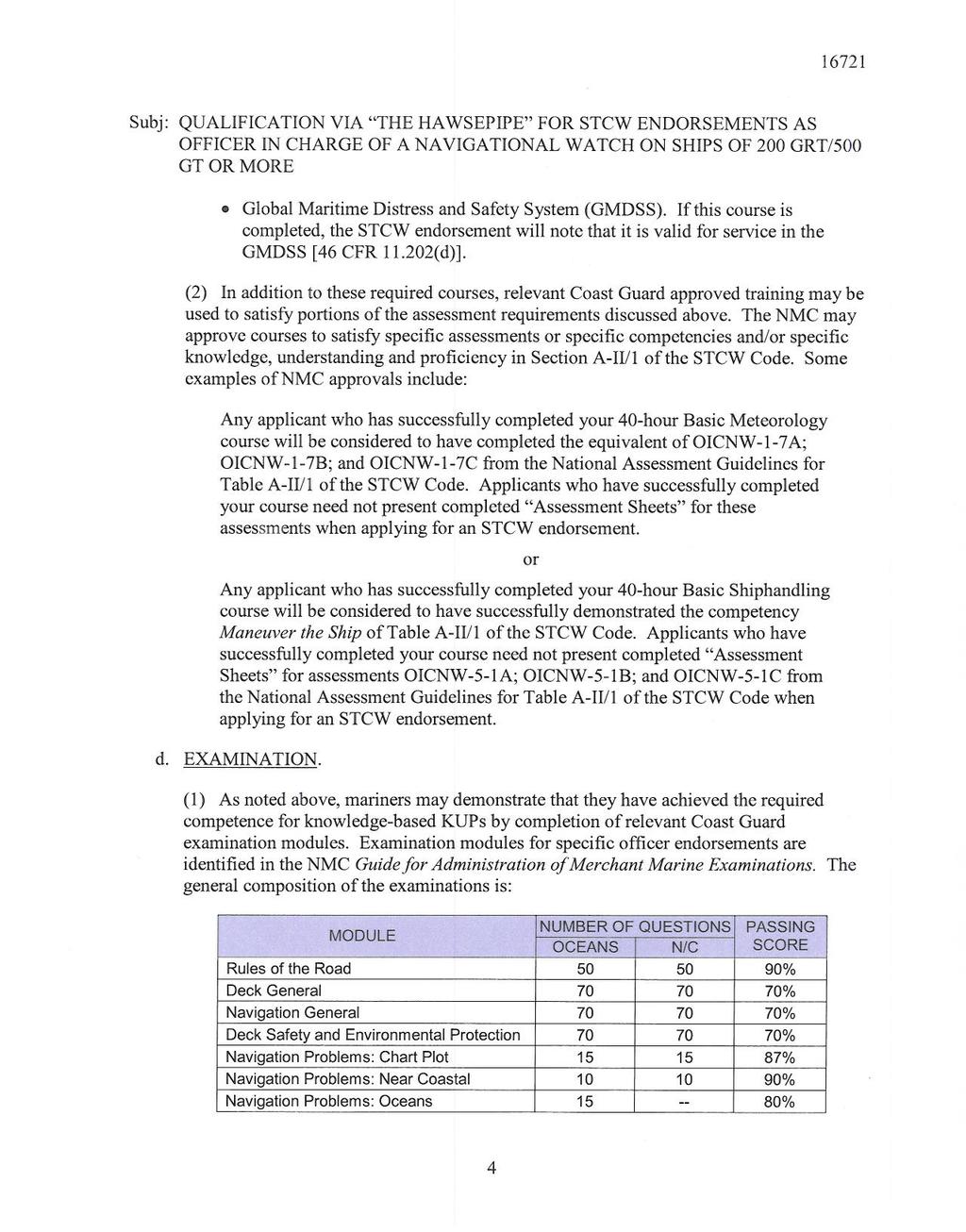
37 ASSESSMENT NO. OICNW-2-1A COMPETENCE: Maintain a safe navigational watch KNOWLEDGE, UNDERSTANDING & PROFICIENCY: Watchkeeping -- Thorough knowledge of the content, application and intent of the International Regulations for Preventing Collisions at Sea TASK: Identify light configurations PERFORMANCE CONDITION: At night, on a ship underway, a full mission ship simulator, or using approved laboratory equipment. PERFORMANCE BEHAVIOR: Identify vessels through observation of their light configurations. The candidate correctly identifies the situation or occupation of 18 of 20 vessels that have different light configurations. s Mariner
38 ASSESSMENT NO. OICNW-2-1B COMPETENCE: Maintain a safe navigational watch KNOWLEDGE, UNDERSTANDING & PROFICIENCY: Watchkeeping -- Thorough knowledge of the content, application and intent of the International Regulations for Preventing Collisions at Sea TASK: Identify day shapes PERFORMANCE CONDITION: In daylight, on a ship underway, a full mission ship simulator, or using approved laboratory equipment. PERFORMANCE BEHAVIOR: Identify vessels through observation of their required shapes. The candidate correctly identifies the situation or occupation of 18 of 20 vessels that are displaying different required shapes. s Mariner
39 ASSESSMENT NO. OICNW-2-1C COMPETENCE: Maintain a safe navigational watch KNOWLEDGE, UNDERSTANDING & PROFICIENCY: Watchkeeping -- Thorough knowledge of the content, application and intent of the International Regulations for Preventing Collisions at Sea TASK: Identify sound signals PERFORMANCE CONDITION: In restricted visibility, on a ship underway, a full mission ship simulator, or using approved laboratory equipment. PERFORMANCE BEHAVIOR: Identify vessels by hearing their required sound signals. The candidate correctly identifies the situation or occupation of 9 of 10 vessels sounding different required sound signals. s Mariner
40 ASSESSMENT NO. OICNW-2-1D COMPETENCE: Maintain a safe navigational watch KNOWLEDGE, UNDERSTANDING & PROFICIENCY: Watchkeeping -- Thorough knowledge of the content, application and intent of the International Regulations for Preventing Collisions at Sea TASK: Determine risk of collision PERFORMANCE CONDITION: On a ship underway, a full mission ship simulator, or using approved laboratory equipment, and using a gyro-compass repeater and an azimuth circle, bearing circle, alidade, or other device for taking bearings, and a marine radar or ARPA meeting IMO performance standards set on the 12 mile scale and the targets more than 8 miles away. PERFORMANCE BEHAVIOR: Determine if risk of collision exists with approaching meeting, crossing and overtaking vessels. 1. Two visual bearings of an approaching vessel are taken using an azimuth circle, bearing circle or alidade to determine if the bearing to the approaching vessels is appreciably changing, and each observation is within ± 2 of the assessor s solution; and 2. Two electronic bearings of an approaching vessel are taken on a radar or an ARPA to determine if the bearing to the approaching vessels are appreciably changing, and each observation is within ± 2 of the assessor s solution. s Mariner
41 ASSESSMENT NO. OICNW-2-1E COMPETENCE: Maintain a safe navigational watch KNOWLEDGE, UNDERSTANDING & PROFICIENCY: Watchkeeping -- Thorough knowledge of the content, application and intent of the International Regulations for Preventing Collisions at Sea TASK: Maneuver to avoid risk of collision -- meeting PERFORMANCE CONDITION: On a ship underway, a full mission ship simulator, or using approved laboratory equipment, when risk of collision with an approaching meeting vessel exists in good visibility in the open ocean. PERFORMANCE BEHAVIOR: Apply the rules of the road correctly and maneuver the vessel to avoid the collision, if required. 1. The aspect of the approaching vessel was determined; 2. The situation was identified as a meeting situation; 3. Positive action was taken in ample time in accordance with the steering and sailing rules to achieve a CPA of at least 3 nm; and 4. Speed or course changes were made that were large enough to be readily apparent to another vessel observing visually or by radar. s Mariner
42 ASSESSMENT NO. OICNW-2-1F COMPETENCE: Maintain a safe navigational watch KNOWLEDGE, UNDERSTANDING & PROFICIENCY: Watchkeeping -- Thorough knowledge of the content, application and intent of the International Regulations for Preventing Collisions at Sea TASK: Maneuver to avoid risk of collision -- overtaking PERFORMANCE CONDITION: On a ship underway, a full mission ship simulator, or using approved laboratory equipment, when risk of collision with an approaching overtaking vessel exists in good visibility in the open ocean. PERFORMANCE BEHAVIOR: Apply the rules of the road correctly and maneuver the vessel to avoid the collision, if required. 1. The aspect of the approaching vessel was determined; 2. The situation was identified as an overtaking situation; 3. The candidate attempted to call the overtaking vessel on the VHF; 4. The danger signal was sounded, if required by the rules; 5. Positive action in ample time was taken in accordance with Rule 17 of the steering and sailing rules to achieve a CPA of at least 1 nm; and 6. Speed or course changes were made that were large enough to be readily apparent to another vessel observing visually or by radar. s Mariner
43 ASSESSMENT NO. OICNW-2-1G COMPETENCE: Maintain a safe navigational watch KNOWLEDGE, UNDERSTANDING & PROFICIENCY: Watchkeeping -- Thorough knowledge of the content, application and intent of the International Regulations for Preventing Collisions at Sea TASK: Maneuver to avoid risk of collision -- crossing PERFORMANCE CONDITION: On a ship underway, a full mission ship simulator, or using approved laboratory equipment, when risk of collision with an approaching crossing vessel (from the candidate s starboard side at a relative bearing of between 30 degrees and degrees) exists in good visibility in the open ocean. PERFORMANCE BEHAVIOR: Apply the rules of the road correctly and maneuver the vessel to avoid the collision, if required. 1. The aspect of the approaching vessel was determined; 2. The situation was identified as a crossing situation; 3. Positive action in ample time was taken in accordance with the steering and sailing rules to achieve a CPA of at least 3 nm; and 4. Speed or course changes were made that were large enough to be readily apparent to another vessel observing visually or by radar. s Mariner
44 ASSESSMENT NO. OICNW-2-2A COMPETENCE: Maintain a safe navigational watch KNOWLEDGE, UNDERSTANDING & PROFICIENCY: Watchkeeping -- Thorough knowledge of the principles to be observed in keeping a safe watch TASK: Watch relief PERFORMANCE CONDITION: On a ship underway or a full mission ship simulator during an exercise at sea. PERFORMANCE BEHAVIOR: Properly relieve the watch in accordance with STCW Code Section A-VIII/2, Part 3-1, Paragraphs 21 and The standing orders and night orders were read; 2. The vessel s position, course and speed are read from the GPS receiver and compared to the DR position and track; 3. The position of the next charted waypoint is compared to the GPS waypoint and the route print out; 4. The identity of critical aids to navigation in sight is verified; 5. Tides and currents are determined as necessary; 6. Visibility and weather are determined; 7. The radar or ARPA is checked and is properly tuned; 8. Any targets displayed on the radar or ARPA are checked; 9. Headings by magnetic and gyrocompass are checked; 10. The navigational hazards likely to be encountered during the watch are determined; 11. The possible effects of list, trim, water density and squat on under keel clearance are determined; 12. Courses, traffic, weather and any special instructions were related by the officer being relieved; and 13. The relieving officer told the officer being relieved he or she was relieved. s Mariner
45 ASSESSMENT NO. OICNW-2-2B COMPETENCE: Maintain a safe navigational watch KNOWLEDGE, UNDERSTANDING & PROFICIENCY: Watchkeeping -- Thorough knowledge of the principles to be observed in keeping a safe watch TASK: Keep a safe navigation watch PERFORMANCE CONDITION: On a ship underway or a full mission ship simulator during an exercise at sea. PERFORMANCE BEHAVIOR: Properly keep a safe navigational watch in accordance with STCW Code Section A-VIII/2, Part 3-1, Paragraph 23 to The voyage plan was closely and continuously monitored; 2. A proper look out was maintained by all available means; 3. A safe speed was maintained throughout the watch period; 4., course and speed were checked at frequent intervals; 5. The steering mode selected was appropriate to the area being transited; 6. Ensures that under keel clearance was suitable for the draft of the vessel at all times; 7. Course changes were made in accordance with the voyage plan; 8. The vessel s position was fixed and plotted on an appropriate chart at intervals suitable to the vessel s speed and the area being transited; 9. The identity of critical aids to navigation in sight is determined; 10. More than one method, including electronic and other navigational equipment, external fixed aids, geographic reference points, and hydrographic contours, is used to fix the vessel s position and check the accuracy of fixes; 11. Radio equipment was frequently checked to verify it is functioning properly; 12. The risk or danger of collision with each approaching vessel is determined and early and substantial action is taken in accordance with the COLREGS to avoid collisions; 13. Rudder and engine orders were executed as ordered; 14. The validity of the gyro input to all navigation equipment is verified; 15. Gyrocompass error was determined by any available means and the error was logged; 16. Magnetic variation and compass deviation were correctly applied to courses and bearings; 17. The candidate determined the person steering the vessel was competent to do so; 18. Tide and current conditions for the watch period were determined in coastal or tidal waters; 19. Set and drift were determined and applied to allow for set and drift; 20. The weather conditions at the ship were correctly and timely recorded and reported as required; 21. Running lights were checked throughout the watch period; 22. The master was notified as directed by all master s or standing orders; 23. All required log entries were made; and 24. All relevant navigation information was used to identify protected marine habitats, areas, and sanctuaries s Mariner
46 ASSESSMENT NO. OICNW-2-2C COMPETENCE: Maintain a safe navigational watch KNOWLEDGE, UNDERSTANDING & PROFICIENCY: Watchkeeping -- Thorough knowledge of the principles to be observed in keeping a safe watch TASK: Notify Master when appropriate PERFORMANCE CONDITION: On a ship underway or a full mission ship simulator during an exercise at sea. PERFORMANCE BEHAVIOR: Notify the master as instructed, and when in doubt of other vessels intentions, or in any circumstances that affect the routine navigation of the vessel in accordance with STCW Code Section A-VIII/2, Part 3-1, Paragraph 40. The master was notified immediately when one of the following occurred. 1. Restricted visibility was encountered or expected; 2. Vessel traffic density or the movements of other ships caused concern; 3. Difficulty was experienced in maintaining course; 4. Failed to sight land or a navigational mark, or to obtain soundings when expected; 5. Aids to navigation were not in position or were displaying incorrect characteristics; 6. Land or a navigational mark was unexpectedly sighted, or soundings obtained or changed unexpectedly; 7. The engines or its control systems, steering, or any essential navigational equipment failed, or alarms or indicators for these systems sounded; 8. Failure of any radio equipment; 9. Concerns arose in heavy weather about damage to the vessel or its cargo; 10. Any hazard to navigation that posed a threat to the vessel was noticed; 11. Any doubt about the ship s safety or other emergency arose; or 12. Any changes are made to the voyage plan. s Mariner
47 ASSESSMENT NO. OICNW-2-2D COMPETENCE: Maintain a safe navigational watch KNOWLEDGE, UNDERSTANDING & PROFICIENCY: Watchkeeping -- Thorough knowledge of the principles to be observed in keeping a safe watch TASK: Keep a safe anchor watch PERFORMANCE CONDITION: On a ship at anchor or a full mission ship simulator during an exercise at anchor with wind and seas building. PERFORMANCE BEHAVIOR: Properly keep a safe anchor watch in accordance with STCW Code Section A-VIII/2, Part 3-1, Paragraph Determined and plotted the ship s position; 2. Frequently checked the ship s position by visual and radar bearings and radar ranges from the same charted objects; 3. Established the GPS or DGPS anchor alarm; 4. Maintained a proper lookout; 5. Ensured periodic inspections were made; 6. Posted a rating at the anchor to carry out orders with respect to the anchor; 7. Monitored weather, tides and sea state; 8. Notified the master immediately when the weather changed, visibility became restricted, or the anchor started to drag; 9. Placed engines on standby and ensured that they are ready for immediate use where appropriate; and 10. Properly displayed all required lights and shapes and sounded proper sound signals. s Mariner
48 ASSESSMENT NO. OICNW-2-2E COMPETENCE: Maintain a safe navigational watch KNOWLEDGE, UNDERSTANDING & PROFICIENCY: Watchkeeping -- Thorough knowledge of the principles to be observed in keeping a safe watch TASK: Navigate in restricted visibility PERFORMANCE CONDITION: On a ship at sea or a full mission ship simulator during an exercise at sea, when visibility becomes restricted while underway. PERFORMANCE BEHAVIOR: Recognize the restricted visibility take the appropriate action to navigate in restricted visibility in accordance with the COLREGS in accordance with Section STCW Code A-VIII/2, Part 3-1, Paragraph The restricted visibility was determined; 2. The master was notified; 3. Steering was switched to hand steering; 4. A proper lookout was posted and the running lights turned on; 5. The vessel s speed was set in accordance with Rule 6; 6. Sounding of required signals was commenced; 7. The radar or ARPA was set on the appropriate scale to scan at long range for the presence of other vessels; and 8. Approaching targets were plotted or the ARPA or radar was used to obtain early warning of risk of collision and determine the speed and direction of relative motion. s Mariner
49 ASSESSMENT NO. OICNW-2-2F COMPETENCE: Maintain a safe navigational watch KNOWLEDGE, UNDERSTANDING & PROFICIENCY: Watchkeeping -- Thorough knowledge of the principles to be observed in keeping a safe watch TASK: Turn over a watch PERFORMANCE CONDITION: On a ship at sea or a full mission ship simulator during an exercise at sea. PERFORMANCE BEHAVIOR: Turn the watch over. 1. A DR position was plotted on the chart in use for the end of the watch; 2. The ship's position was determined and plotted all by means appropriate to the area transited; 3. Required weather data was read and recorded in the deck log; 4. The heading of the gyro and magnetic compasses were compared and recorded; 5. The movement of all vessel traffic was checked by both visual and electronic means immediately before being relieved; 6. The vessel s course and speed, posting of special lookouts, the steering mode in use, and weather and visibility were relayed to the relieving officer; 7. Any special instructions regarding occurrences during the past watch or which are expected during the next watch were relayed; 8. All relevant information concerning vessels in sight or on the radar or ARPA was reported to the relieving officer; 9. The master is notified of any doubt that the relieving officer is competent to perform his or her duties; 10. The watch was not turned over during a maneuver or other action to avoid a hazard to navigation; and 11. The officer being relieved did not leave the bridge until informed by the relieving officer that he or she is ready to take the watch. s Mariner
50 ASSESSMENT NO. OICNW-2-3A COMPETENCE: Maintain a safe navigational watch KNOWLEDGE, UNDERSTANDING & PROFICIENCY: Watchkeeping -- Thorough knowledge of effective bridge teamwork procedures TASK: Voyage planning PERFORMANCE CONDITION: On a ship, a full mission ship simulator, or in a navigation laboratory, when given a port of departure and a port of arrival more than 1,000 apart. PERFORMANCE BEHAVIOR: Plan a voyage and review the voyage plan with the master and deck officers. Appraisal -- Take into account paragraph 2 of the annex to IMO Assembly Resolution A 893(21): 1. The condition of the vessel, its stability, equipment, operational limitations, draft and maneuvering characteristics; 2. Any special characteristics of the cargo and its stowage; 3. Crew members competency and rest status; 4. The status of all ship s certificates and documents were up to date; 5. Up to date charts of proper scale, and the latest notices to mariners and radio navigational warnings; 6. Up to date coast pilots, sailing directions, and other information sources appropriate for the voyage; 7. Relevant routing guides; 8. Up to date tide and current tables and atlases; 9. Weather information; 10. Weather routing services; 11. Ship reporting systems, VTS and environmental protection measures; 12. Vessel traffic density for the route; 13. Pilotage requirements and information exchange; and, 14. Port information, including emergency response capability. Planning -- Plan contains the following per para. 3 of the annex to IMO Assembly Resolution A 893(21): 15. Courses plotted on the appropriately scaled charts noting the ETA at each way point, including the final way point; 16. Courses and distances between way points were correctly calculated and indicated on the charts; 17. The most direct route that avoided all hazards to navigation by the margin of safety of 3 nm; 18. The areas of all required speed changes; 19. The minimum under keel clearances in critical areas; positions requiring a change of machinery status; 20. s requiring a change of machinery status; 21. Waypoint of all course changes; 22. The methods and frequency of position fixing, including areas requiring the highest accuracy; 23. The positions and radio hailing frequencies or channels where port authorities, pilots and VTS services must be notified were noted on the relevant chart; 24. The state of the tide and currents at the port of departure for the times of departure and transit were determined; 25. Contingency plan for alternative actions in cases of emergency; 26. The review of the voyage plan with the Master and deck officers. 27. All relevant navigation information used to identify protected marine habitats, areas and sanctuaries. s Mariner
51 ASSESSMENT NO. OICNW-2-3B COMPETENCE: Maintain a safe navigational watch KNOWLEDGE, UNDERSTANDING & PROFICIENCY: Watchkeeping -- Thorough knowledge of effective bridge teamwork procedures TASK: Execute a voyage plan PERFORMANCE CONDITION: On a ship, or a full mission ship simulator, when given a voyage plan. PERFORMANCE BEHAVIOR: Execute the voyage plan. The candidate, in accordance with paragraph 4 and 5 of the annex to IMO Assembly Resolution A 893(21): 1. Checks the reliability and condition of the navigational equipment at frequent intervals; 2. Applies basic information obtained from the tide tables and other navigational publications to determine under keel clearance; 3. Fixes the vessels position at appropriate intervals; 4. Checks magnetic and gyro-compasses; 5. Assesses meteorological information; 6. Determined compass error; 7. Calculates sailings for up to 24 hours; 8. Correctly operates and applied information from electronic navigation systems; 9. Correctly operates the radar and ARPA and applied the information for navigation and collision avoidance; 10. Correctly operates propulsion and steering systems to control heading and speed; 11. Initiates action in event of a real or simulated equipment malfunction or failure of major items of equipment; 12. Correctly conducts radio-communications; 13. Monitored and correctly operates safety and alarm systems. 14. Closely and continuously monitors the voyage plan. s Mariner
52 ASSESSMENT NO. OICNW-2-3C COMPETENCE: Maintain a safe navigational watch KNOWLEDGE, UNDERSTANDING & PROFICIENCY: Watchkeeping -- Thorough knowledge of effective bridge teamwork procedures TASK: BRM Recognition of watch condition PERFORMANCE CONDITION: On a ship at sea or a full mission ship simulator during an exercise at sea, when help is needed because of restricted visibility, vessel traffic or safety of navigation. PERFORMANCE BEHAVIOR: Recognize the need for additional personnel on the bridge and notify the master. The candidate notifies the master immediately if: 1. The vessel encounters or expects to encounter restricted visibility; 2. There is cause for concern because of vessel traffic density or the movements of other ships; 3. the vessel will transit restricted waters with vessel traffic; or 4. he or she was fatigued to the point that decision making is affected. s Mariner
53 ASSESSMENT NO. OICNW-2-3D COMPETENCE: Maintain a safe navigational watch KNOWLEDGE, UNDERSTANDING & PROFICIENCY: Watchkeeping -- Thorough knowledge of effective bridge teamwork procedures TASK: BRM Condition III collision avoidance. PERFORMANCE CONDITION: the ship is navigating near land, shoals or with increased traffic density and/or restricted visibility. This condition requires concentrated navigation and observation of traffic for collision avoidance (entering or leaving port). On a ship at sea or a full mission ship simulator during an exercise at sea, and with a bridge team in place for navigating in congested near coastal waters with or without reduced visibility, and assigned to monitor vessel traffic using an IMO compliant ARPA. The ship is navigating near land, shoals, or with increased traffic density and/or restricted visibility. PERFORMANCE BEHAVIOR: Identify all vessels (targets) posing a risk or danger of collision, and provide appropriate information and recommendations on vessel traffic and any other situation or condition that may effect the safe navigation of the vessel to the conning officer. 1. The risk and danger of collision of all approaching vessels is determined within 6 minutes; 2. The conning officer was immediately notified of the relative position of the threatening vessel, its CPA and TCPA; 3. Course changes in accordance with the COLREGS to remove the risks of collision and avoid the close quarters situations from developing were recommended; 4. All recommended course or speed changes resulted in increasing the CPA to approaching vessels identified as posing a risk or danger of collision; 5. All recommended course changes provided sufficient sea room and bottom clearance for the area transited; 6. Communication was clear, immediate, reliable and relevant; and 7. Non-essential activities were avoided. s Mariner
54 ASSESSMENT NO. OICNW-2-3E COMPETENCE: Maintain a safe navigational watch KNOWLEDGE, UNDERSTANDING & PROFICIENCY: Watchkeeping -- Thorough knowledge of effective bridge teamwork procedures TASK: BRM Condition III navigation PERFORMANCE CONDITION: On a ship at sea or a full mission ship simulator during an exercise at sea, and with a bridge team in place for navigating in congested near coastal waters with or without reduced visibility, and assigned to monitor the vessel s position, communicate on the VHF, and all other bridge duties, using an IMO compliant ARPA, a GPS or DGPS receiver and all other bridge navigational equipment identified in the performance standard. PERFORMANCE BEHAVIOR: Determine and plot the vessel s position by electronic and visual means, communicate as required on the VHF, and carry out all engine commands, ensure that all rudder commands are properly carried out, and make all appropriate log book entries. 1. Visual and electronic means were used to determine the ship s position, including GPS or DGPS, radar, ARPA, ECDIS (if fitted), and Echo Sounder; 2. The vessel s position was plotted in accordance with tolerances stated previously at regular intervals appropriate to the vessel s speed and the area transited; 3. The correct courses to steer to maintain the ship on the intended track were determined and recommended to the conning officer; 4. All VHF calls to own ship were answered and calls to other ships in the area and port authorities were made as required; 5. The helmsman was monitored to ensure all rudder commands were carried out; 6. Communication was clear, immediate, reliable and relevant; 7. Non-essential activities were avoided; and 8. All required entries in the appropriate vessel s logs were made. s Mariner
55 ASSESSMENT NO. OICNW-2-3F COMPETENCE: Maintain a safe navigational watch KNOWLEDGE, UNDERSTANDING & PROFICIENCY: Watchkeeping -- Thorough knowledge of effective bridge teamwork procedures TASK: BRM Condition II or III error trapping PERFORMANCE CONDITION: The ship is underway offshore in restricted visibility, with increased traffic, land or shoals affecting navigation (coastwise navigation). On a ship at sea or a full mission ship simulator during an exercise at sea, and with a bridge team in place for navigating in congested near coastal waters with or without reduced visibility, and assigned duties as an officer in a Bridge Team, when one of the following occur: 1. an incorrect rudder order is given; 2. a rudder or engine command is not given at the proper time; 3. a navigational aid is misidentified; 4. the vessel s position is improperly fixed; or 5. a target vessel s movements are improperly stated. PERFORMANCE BEHAVIOR: Monitor vessel s movement, recognize erroneously stated information about the vessel s position or a target vessels movement, and notify the conning officer of specific questions regarding the vessel s situation. 1. The misinformation or command error was detected. 2. The conning officer was notified within 30 seconds of the occurrence of the error (for helm orders, the candidate will detect the error and issue a corrective order within 5 seconds). s Mariner
56 ASSESSMENT NO. OICNW-2-3G COMPETENCE: Maintain a safe navigational watch KNOWLEDGE, UNDERSTANDING & PROFICIENCY: Watchkeeping -- Thorough knowledge of effective bridge teamwork procedures TASK: BRM Condition II navigation & collision avoidance PERFORMANCE CONDITION: On a ship at sea or a full mission ship simulator during an exercise at sea, when acting as part of the bridge team with assigned duties to monitor the vessel s navigation and determine the risk or danger of collision with all vessels underway in open sea, using an ARPA meeting all national and international performance requirements, a GPS or DGPS receiver and all the bridge equipment identified in the performance standard. PERFORMANCE BEHAVIOR: Determine and plot the vessel s position at suitable intervals, and plot or systematically observe all approaching vessels and inform the bride team of dangers to navigation, intended course changes, and vessels which pose a risk or danger of collision. 1. The vessel s position was determined and plotted at suitable intervals; 2. All aids to navigation were identified; 3. The bridge team was notified immediately of the following: a) when planned course changes must be made; b) effects of tides or currents setting the vessel off its intended course: or, c) any doubt about the vessel s position. 4. The risk and danger of collision with approaching vessels in the vicinity were determined by visual and radar/arpa bearings. 5. The bridge team was notified of the following: a) danger or risk of collision with any approaching vessel; b) recommended course change to avoid the risk or danger of collision; and, c) recommended speed change to avoid the risk or danger of collision if the engines are available for immediate use. s Mariner
RECORD OF ASSESSMENT
 RECORD OF ASSESSMENT This record booklet can be used to document your completion of the proficiency assessments for Officer in Charge of the Navigational Watch (OICNW) in order to meet U.S. Coast Guard
iii) Satisfactory completion of approved training in the following:
 Satisfactory completion of approved training in the following:") Enclosure (1) to NVIC 13-14 DISCUSSION OF QUALIFICATION REQUIREMENTS FOR MASTER AND OFFICER IN CHARGE OF A NAVIGATIONAL WATCH ON VESSELS OF LESS THAN 500 GT LIMITED TO NEAR-COASTAL WATERS 1. GENERAL. This
Enclosure (1) to NVIC 13-14 DISCUSSION OF QUALIFICATION REQUIREMENTS FOR MASTER AND OFFICER IN CHARGE OF A NAVIGATIONAL WATCH ON VESSELS OF LESS THAN 500 GT LIMITED TO NEAR-COASTAL WATERS 1. GENERAL. This
COMDTCHANGENOTE NVIC February 21, 2017
 Commandant United States Coast Guard US Coast Guard Stop 7509 2703 Martin Luther King Jr Ave SE Washington, DC 20593-7509 Staff Symbol: CG-MMC-2 Phone: 202-372-2357 Fax: 202-372-1246 Email: MMCPolicy@uscg.mil
NAVIGATION AND VESSEL INSPECTION CIRCULAR NO , CH 1
 Commandant United States Coast Guard US Coast Guard Stop 7509 2703 Martin Luther King Jr Ave SE Washington, DC 20593-7509 Staff Symbol: CG-MMC-2 Phone: 202-372-2357 Fax: 202-372-1246 Email: MMCPolicy@uscg.mil
NAVIGATION AND VESSEL INSPECTION CIRCULAR NO
 Commandant United States Coast Guard US Coast Guard Stop 7509 2703 Martin Luther King Jr. Ave. SE Washington, DC 20593-7509 Staff Symbol: CG-MMC Phone: (202) 372-2357 Fax: (202) 372-1246 E-Mail: MMCPolicy@uscg.mil
NAVIGATION AND VESSEL INSPECTION CIRCULAR NO , CH-2
 Commandant United States Coast Guard US Coast Guard Stop 7509 2703 Martin Luther King Jr. Ave. SE Washington, DC 20593-7509 Staff Symbol: CG-MMC Phone: (202) 372-2357 Fax: (202) 372-1246 E-Mail: MMCPolicy@uscg.mil
properly applied assessment in the use.1 landmarks.1 approved in-service of ECDIS is not experience The primary method of fixing required for those
 STCW Code Table A-II/3 Specification of minimum standard of for officers in charge of a navigational watch and for masters on ships of less than 500 gross tonnage engaged on near-coastal voyages Ref: https://www.edumaritime.net/stcw-code
OPERATIONS SEAFARER CERTIFICATION GUIDANCE NOTE SA MARITIME QUALIFICATIONS CODE. Deck: Chart Work
 Page 1 of 6 Compiled by Approved by Chief Examiner Syllabus Committee: 26 February 2013 OPERATIONS SEAFARER CERTIFICATION GUIDANCE NOTE SA MARITIME QUALIFICATIONS CODE Deck: Chart Work Page 2 of 6 COLUMN
JANUARY 2013 FEBRUARY CONSTB ROP-5 FF-BADV TCNAV / CO GMDSS Optional MED-PIC ARPA MED-PIC MED-PRO BRM BAS-SHS MED-PRO BRM SHS BAS
 2013 OFFICER IN CHARGE OF THE NAVIGATIONAL WATCH (2 ND 3 RD MATE AGT, 500 / 1600 MATE Ocean, Near Coastal, MATE OSV & OFFICER IN CHARGE OF THE NAVIGATIONAL WATCH) JANUARY 2013 FEBRUARY 2013 Dec 31-Jan6
NAEST(M) training Course Structure and Session Objectives. Day Introduction and enrolment
 training Course Structure and Session Objectives. Day Introduction and enrolment") NAEST(M) training Course Structure and Session Objectives Day 1 0830-0930 Introduction and enrolment 0930-1330 Effective Bridge Procedures & Rule of the Road Lecturer will go through the PowerPoint on
NAEST(M) training Course Structure and Session Objectives Day 1 0830-0930 Introduction and enrolment 0930-1330 Effective Bridge Procedures & Rule of the Road Lecturer will go through the PowerPoint on
COMDTCHANGENOTE NVIC February 21, 2017
 Commandant United States Coast Guard US Coast Guard Stop 7501 2703 Martin Luther King Jr. Ave. SE Washington, DC 20593-7501 Staff Symbol: CG-MMC-2 Phone: (202) 372-2357 Fax: (202) 372-1246 E-Mail: MMCPolicy@uscg.mil
COMDTCHANGENOTE NVIC February 21, 2017
 Commandant United States Coast Guard US Coast Guard Stop 7509 2703 Martin Luther King Jr. Ave. SE Washington, DC 20593-7509 Staff Symbol: CG-MMC-2 Phone: (202) 372-2357 Fax: (202) 372-1246 E-Mail: MMCPolicy@uscg.mil
NAVIGATION AND VESSEL INSPECTION CIRCULAR NO
 Commandant United States Coast Guard 2703 Martin Luther King Jr. Ave SE Stop 7509 Washington, DC 20593-7501 Staff Symbol: CG-MMC-2 Phone: (202) 372-2357 Fax: (202) 372-4908 E-Mail: MMCPolicy@uscg.mil COMDTPUB
Minimum standard of competence for Master (STCW Reg II/2)
") Minimum standard of for Master (STCW Reg II/2) Function: Navigation at the management level Column 1 Column 2 Column 3 Column 4 Plan a voyage and Voyage planning and Examination and The equipment, charts
Minimum standard of for Master (STCW Reg II/2) Function: Navigation at the management level Column 1 Column 2 Column 3 Column 4 Plan a voyage and Voyage planning and Examination and The equipment, charts
Report on Vessel Casualty of Accident (Form Casualty) Instructions:
 Instructions:") Report on Vessel Casualty of Accident (Form Casualty) Tuvalu Ship Registry 10 Anson Road #25-16 International Plaza Singapore 079903 Tel: (65) 6224 2345 Fax: (65) 6227 2345 Email: info@tvship.com Website:
Report on Vessel Casualty of Accident (Form Casualty) Tuvalu Ship Registry 10 Anson Road #25-16 International Plaza Singapore 079903 Tel: (65) 6224 2345 Fax: (65) 6227 2345 Email: info@tvship.com Website:
MANAGEMENT SYSTEM MANUAL
 1. Purpose The purpose of this procedure is to establish routine check-off lists to be used in preparation for arrival and departure aboard the R/V Oceanus. 2. Responsibility The Master is responsible
Competency framework for Skipper Coastal / Offshore. Competency framework for Skipper Coastal/ Offshore
 Competency framework for Skipper Coastal/ Offshore Table of Contents... 1... 1 Function: Safety at the management level... 11 Manage safety aboard a coastal and vessel... 11 Competency framework for Skipper
REALIZE YOUR POTENTIAL:
 REALIZE YOUR POTENTIAL: ABLE SEAFARER TO MATE PROGRAM www.mitags-pmi.org r012913 Able Seafarer to Mate Able Seafarer Deck to STCW95 Officer In Charge of a Navigation Watch MITAGS/PMI THREE OPTIONS TO MATE
Rule 5 - Look-out. 1
 Every vessel shall at all times maintain a proper look-out by sight and hearing as well as by all available means appropriate in the prevailing circumstances and conditions so as to make a full appraisal
Navigation Exercises for Practice Underway
 Workforms and Plotting Sheets for use with Navigation Exercises for Practice Underway www.starpath.com/kindle David Burch STARPATH Seattle, WA Copyright 2009, 2012 David Burch All rights reserved. No part
Towing Officers' Assessment Record: Near Coastal/Oceans
 Towing Officers' Assessment Record: Near Coastal/Oceans NAME: LICENSE NO.: Task No. Considered Proficient Common Element Task or Duty DE's Initials Date A. Vessel Familiarization A.1. X Locate and demonstrate
Incident Report. Close Quarters Pegasus II & Distraction. 26 April 2006 Class B
 Incident Report Close Quarters Pegasus II & Distraction 26 April 2006 Class B NARRATIVE Pegasus II (See Photograph 1 Pegasus II) is a 15.46 metre commercial fishing vessel with a gross tonnage of 40. She
Rule 7 - Risk of collision
 a) Every vessel shall use all available means appropriate to the prevailing circumstances and conditions to determine if risk of collision exists. If there is any doubt such risk shall be deemed to exist.
OPERATIONS SEAFARER CERTIFICATION GUIDANCE NOTE
 Page 1 of 9 Compiled by Chief Examiner Approved by Executive Head: Centre of Seafarers OPERATIONS SEAFARER CERTIFICATION GUIDANCE NOTE Page 2 of 9 Content STCW 78 AS AMENDED DECK OFFICER ORAL EXAMINATION
Uncontrolled document if printed.
 APPENDIX 3 APPRENTICE PILOT S TRAINING SYLLABUS Issue Date: 16 th March, 2010 Date of Revision: 22nd May, 2013 Revision #2 i THE PURPOSE OF THIS SYLLABUS The purpose of this training syllabus is to ensure
IMO RESOLUTION A.960(23) Adopted 5 December 2003 (Agenda item 17)
 Adopted 5 December 2003 (Agenda item 17)") INTERNATIONAL MARITIME ORGANIZATION E IMO ASSEMBLY 23rd session Agenda item 17 A 23/Res.960 5 March 2004 Original: ENGLISH RESOLUTION A.960(23) Adopted 5 December 2003 (Agenda item 17) RECOMMENDATIONS
INTERNATIONAL MARITIME ORGANIZATION E IMO ASSEMBLY 23rd session Agenda item 17 A 23/Res.960 5 March 2004 Original: ENGLISH RESOLUTION A.960(23) Adopted 5 December 2003 (Agenda item 17) RECOMMENDATIONS
Rules Practice Exam 14
 1 BOTH INTERNATIONAL & INLAND Additional light signals are provided in the Annexes to the Rules for vessels. A. engaged in fishing B. not under command C. engaged in towing D. under sail 2 BOTH INTERNATIONAL
SAMPLE COASTAL SKIPPER CHARTWORK QUESTIONS Updated 17 October 2008
 SAMPLE COASTAL SKIPPER CHARTWORK QUESTIONS Updated 17 October 2008 Unless otherwise specified, all chartwork questions relate to chart SAN 3002. Some questions may ask you to use deviation card No1 for
Rule 8 - Action to avoid collision
 a) Any action to avoid collision shall be taken in accordance with the Rules of this Part and shall, if the circumstances of the case admit, be positive, made in ample time and with due regard to the observance
NAVIGATION ACCIDENTS AND THEIR CAUSES IS SHIPBOARD TECHNOLOGY A HELP OR HINDERANCE? CAPT.CLEANTHIS ORPHANOS MSc HEAD MAIC SERVICE
 NAVIGATION ACCIDENTS AND THEIR CAUSES IS SHIPBOARD TECHNOLOGY A HELP OR HINDERANCE? CAPT.CLEANTHIS ORPHANOS MSc HEAD MAIC SERVICE Shipboard Technology Radar/Arpa ECDIS GPS/DGPS/ LRIT VDR Loran Gyro compass
Rules Practice Exam 7
 1 INTERNATIONAL ONLY The light which may be used with a vessel's whistle is to be. A. used when the whistle is broken B. used prior to sounding the whistle C. used only at night D. a white light 2 INTERNATIONAL
ANY OTHER BUSINESS. Guidelines for passenger ship tender operator. Submitted by Cruise Lines International Association (CLIA) SUMMARY
 SUMMARY") E SUB-COMMITTEE ON STANDARDS OF TRAINING AND WATCHKEEPING 42nd session Agenda item 3 STW 42/13/2 25 October 2010 Original: ENGLISH ANY OTHER BUSINESS Guidelines for passenger ship tender operator Submitted
E SUB-COMMITTEE ON STANDARDS OF TRAINING AND WATCHKEEPING 42nd session Agenda item 3 STW 42/13/2 25 October 2010 Original: ENGLISH ANY OTHER BUSINESS Guidelines for passenger ship tender operator Submitted
International regulations and guidelines for maritime spatial planning related to safe distances to multiple offshore structures (e.g.
 International regulations and guidelines for maritime spatial planning related to safe distances to multiple offshore structures (e.g. wind farms) Introduction This is a summary of the most important international
Regulations of 27 April 1999 No. 537 concerning watchkeeping on passenger ships and cargo ships
 Regulations of 27 April 1999 No. 537 concerning watchkeeping on passenger ships and cargo ships Laid down by the Norwegian Maritime Directorate on 27 April 1999 pursuant to the Act of 9 June 1903 No. 7
SKIPPER CATEGORY B (UP TO 24 NAUTICAL MILES FROM THE SHORE) SYLLABUS
 SYLLABUS") SKIPPER CATEGORY B (UP TO 24 NAUTICAL MILES FROM THE SHORE) SYLLABUS SUBJECTS/TOPICS TOTAL HOURS FOR EACH SUBJECT AREA 1. Candidates may be questioned on Code de la Mer 06 Covered for Skipper 12 Nautical
SKIPPER CATEGORY B (UP TO 24 NAUTICAL MILES FROM THE SHORE) SYLLABUS SUBJECTS/TOPICS TOTAL HOURS FOR EACH SUBJECT AREA 1. Candidates may be questioned on Code de la Mer 06 Covered for Skipper 12 Nautical
Organization of the Watch at Sea
 Organization of the Watch at Sea 1. Master s Responsibilities The Master is bound to ensure that watchkeeping arrangements are adequate for maintaining a safe navigational watch taking into accounts the
TOWING OFFICER ASSESSMENT RECORD
 TOWING OFFICER ASSESSMENT RECORD NEAR COASTAL / OCEANS SIGNATED EXAMINER INFORMATION All Designated Examiners (s) signing off successful completion of practical assessments should provide the information
COMDTPUB P16721 NVIC JAN 2014 GUIDELINES FOR QUALIFICATION FOR STCW ENDORSEMENTS AS RATING FORMING PART OF A NAVIGATIONAL WATCH
 Commandant United States Coast Guard 2703 Martin Luther King Jr. Ave. SE Washington, DC 20593-7501 Staff Symbol: CG-CVC-4 Phone: (202) 372-2357 E-Mail: MMCPolicy@uscg.mil NAVIGATION AND VESSEL INSPECTION
Rules Practice Exam 11
 1 BOTH INTERNATIONAL & INLAND While underway in fog, you hear a vessel sound one prolonged blast followed by two short blasts on the whistle. What does this signal indicate? A. A vessel towing B. A vessel
Rule Conduct of vessels in restricted visibility
 Section III Rule 19 -- Conduct of vessels in restricted visibility (a) This Rule applies to vessels not in sight of one another when navigating in or near an area of restricted visibility. (b) Every vessel
ADMINISTRATIVE INSTRUCTION No. STCW-14 QUALIFICATION / CERTIFICATION REQUIRED FOR OPERATION OF A DOMESTIC VESSESL
 ADMINISTRATIVE INSTRUCTION No. STCW-14 QUALIFICATION / CERTIFICATION REQUIRED FOR OPERATION OF A DOMESTIC VESSESL (Issued under section 3(5) of the Gibraltar Merchant Shipping (Safety etc.) Ordinance 1993
CHAPTER 8 PILOTING DEFINITION AND PURPOSE
 CHAPTER 8 PILOTING DEFINITION AND PURPOSE 800. Introduction Piloting involves navigating a vessel through restricted waters. As in all other phases of navigation, proper preparation and strict attention
CHAPTER 8 PILOTING DEFINITION AND PURPOSE
 CHAPTER 8 PILOTING DEFINITION AND PURPOSE 800. Introduction Piloting involves navigating a vessel in restricted waters and fixing its position as precisely as possible at frequent intervals. More so than
National Maritime Center
 National Maritime Center Providing Credentials to Mariners (Sample Examination) Page 1 of 13 Choose the best answer to the following Multiple Choice Questions. 1. What is the approximate geographic range
Navigation: Navigation In Restricted Visibility. Notice to all Ship Owners, Masters, Skippers, Ships Officers, and Pilots.
 MARINE GUIDANCE NOTE MGN 369 (M+F) Navigation: Navigation In Restricted Visibility Notice to all Ship Owners, Masters, Skippers, Ships Officers, and Pilots. This notice replaces Marine Guidance Note 202
Rules Practice Exam 12
 1 INLAND ONLY You are on vessel "A", and vessel "B" desires to overtake you on your starboard side as shown. After the vessels have exchanged one blast signals, you should. Diagram 31 A. alter course to
NavRule Practice Exam, 70 Series Practice April 24, Labeled F (I received a reply from the testing service that all these answers were
 1. INTERNATIONAL & INLAND An all-round flashing yellow light may be exhibited by a(n)? a. vessel laying cable b. vessel towing a submerged object c. vessel not under command d. air cushion vessel 2. INTERNATIONAL
Please contact our Education Officer if you are interested in any of these courses.
 Please contact our Education Officer if you are interested in any of these courses. Lt/Cdr Jack McKinnon, AP 770-365-9576 or Jakmck@frontier.com Elective Courses Six Elective Courses are offered by USPS.
Supplement to. Navigation Workbook for Practice Underway.
 Supplement to Navigation Workbook for Practice Underway. This file contains duplicate printable workrooms, plotting sheets, and logbook pages to use with the workbook as needed. They are the blank forms
Scientific Journal of Silesian University of Technology. Series Transport Zeszyty Naukowe Politechniki Śląskiej. Seria Transport
 Scientific Journal of Silesian University of Technology. Series Transport Zeszyty Naukowe Politechniki Śląskiej. Seria Transport Volumme 92 2016 p-issn: 0209-3324 e-issn: 2450-1549 DOI: 10.20858/sjsutst.2016.92.12
TECHNICAL CIRCULAR. Circular No: S-P15 /13 Revision: 0 Page: 1 of 9 Date:
 Circular No: S-P15 /13 Revision: 0 Page: 1 of 9 Date:25.04.2013 Related Requirement: UR N1 Subject: One man bridge operated (OMBO) ships Note: For ships contracted for construction as defined in IACS PR29
Navigation for Offshore Sailing
 Navigation for Offshore Sailing This new ship here, is fitted according to the reported increase of knowledge among mankind. Namely, she is cumbered, end to end, with bells and trumpets and clocks and
05 Boat Handling. Captain
 05 Boat Handling Competence (Skills) Knowledge, Understanding and Proficiency Level Required Boat handling theory and techniques Coxswain Crew RQ RQ Describe the forces acting on a vessel while manoeuvering
The Analysis of Possibilities How the Collision Between m/v 'Gdynia' and m/v 'Fu Shan Hai' Could Have Been Avoided
 International Journal on Marine Navigation and Safety of Sea Transportation Volume 2 Number 4 December 2008 The Analysis of Possibilities How the Collision Between m/v 'Gdynia' and m/v 'Fu Shan Hai' Could
 Master
 National Maritime Center
 National Maritime Center Providing Credentials to Mariners Q301 Rules of the Road-Inland (Sample Examination) Page 1 of 19 Choose the best answer to the following Multiple Choice Questions. NO reference
Navigation & Orienteering: Pre- Test
 Name: Class: Answer Key Date: Page 1 of 7 Navigation & Orienteering: Pre- Test There are three sections: Multiple Choice, True/False, and Short Answer. For the multiple choice, please select the BEST answer
UNIT FOUR NAVIGATION TEXTS, TASKS AND PROJECT
 UNIT FOUR TEXTS, TASKS AND PROJECT NAVIGATION - Navigation - Anchoring, Berthing, Leaving berth and Underway - Buoyage - Loading, Discharging & Trim - Project: Pilot Reading Glossary and Practice Navigation
Intermediate Cruising Standard (ASA 104)
") Intermediate Cruising Standard (ASA 104) Prerequisites: Basic Keelboat Sailing (ASA 101) and Basic Coastal Cruising (103) Certification General Description: Demonstrated ability to skipper a sloop-rigged,
Intermediate Cruising Standard (ASA 104) Prerequisites: Basic Keelboat Sailing (ASA 101) and Basic Coastal Cruising (103) Certification General Description: Demonstrated ability to skipper a sloop-rigged,
ECDIS Familiarisation Training
 Chapter 4 ECDIS Familiarisation Training The convention related to the qualifications of seafarers responsible for ship operation is STCW (International Convention on Standards of Training, Certification
Towing Officers' Assessment Record: Western Rivers
 Towing Officers' Assessment Record: Western Rivers NAME: LICENSE NO.: Task No. Considered Proficient Common Element Task or Duty DE's Initials Date A. Vessel Familiarization A.1. X Locate and demonstrate
Enclosure (5) to NVIC 03-16
 to NVIC 03-16") TOWING OFFICER ASSESSMENT RECORD LIMITED LOCAL AREA LOCAL LIMITED AREA (LLA) TOAR INSTRUCTIONS FOR USE The following Towing Officer Assessment Record (TOAR) is intended as a model for endorsements as Limited
TOWING OFFICER ASSESSMENT RECORD LIMITED LOCAL AREA LOCAL LIMITED AREA (LLA) TOAR INSTRUCTIONS FOR USE The following Towing Officer Assessment Record (TOAR) is intended as a model for endorsements as Limited
Qualification details
 Qualification details Title New Zealand Diploma in Fishing Vessel Operations (Level 6) with an optional strand in Fishing Vessel Skipper Version 1 Qualification type Diploma Level 6 Credits 180-245 NZSCED
Collision in restricted visibility
 August 2018 Collision in restricted visibility Vessel A, a container vessel, was approaching the pilot station at full speed which was 17 knots and on a course of 280. It was in the afternoon there was
Rules Practice Exam 5
 1 BOTH INTERNATIONAL & INLAND Vessel "A" (towing) and vessel "B" are meeting as shown. In this situation, which statement is TRUE? Diagram 12 A. Both vessels should alter course to starboard and pass port
Chartwork Learn the basics for position fixing using a number of techniques and a simple equation for speed, distance and time.
 Chartwork Learn the basics for position fixing using a number of techniques and a simple equation for speed, distance and time. Chartwork Chartwork Tools Accurate chart work is the basis for good navigation.
Towing Officers' Assessment Record: Great Lakes/Inland
 Towing Officers' Assessment Record: Great Lakes/Inland NAME: LICENSE NO.: Task No. Considered Proficient Common Element Task or Duty DE's Initials Date A. Vessel Familiarization A.1. Locate and demonstrate
Competency Framework for Advanced Deckhand-Fishing. Competency Framework for Advanced Deckhand-Fishing
 Table of Contents (ADH-F)... 1 Function: Nautical knowledge... 1 Function Fishing Vessel Construction, Deck Equipment and Gear.... 2 Function: Fibre Ropes, Wire Ropes and Chains.... 4 Function: Knots and
Gorgon - Pilotage - Passage Plan - PBG to Gorgon Marine Terminal - Alternative Route
 1.0 Introduction This work instruction outlines the passage plan to be used by vessels transiting from the Port of Barrow Island PBG to the Gorgon Marine Terminal, via the alternative route, with a Pilot
National Maritime Center
 National Maritime Center Providing Credentials to Mariners (Sample Examination) Page 1 of 16 Choose the best answer to the following Multiple Choice Questions. 1. On U.S. charts, you can tell if a named
International Rules for the Prevention of Collisions at Sea Part A-General
 COXSWAIN 1 NEAR COASTAL YOUR STUDY CHECKLIST View the Skills & Knowledge required for National Standard for Commercial Vessels Part D from which oral examinations sample a candidate s proficiency. International
National Maritime Center
 National Maritime Center Providing Credentials to Mariners (Sample Examination) Page 1 of 17 Choose the best answer to the following Multiple Choice questions. 1. Your vessel is steering 263 T at 22 knots.
Rules Practice Exam 9
 1 BOTH INTERNATIONAL & INLAND If your vessel is underway in fog and you hear one prolonged and three short blasts, this is a. A. vessel not under command B. sailing vessel C. vessel being towed (manned)
2 Boating Rules and Regulations... 73
 Contents at a Glance Chapter 1 Boat Design and Construction Chapter 2 Boating Rules and Regulations Chapter 3 Navigation Rules (ColRegs) Chapter 4 Boat Operating and Seamanship Chapter 5 Piloting and Navigation
LOWER MISSISSIPPI RIVER PRE-ENTRY INFORMATION
 LOWER MISSISSIPPI RIVER PRE-ENTRY INFORMATION Notice of Arrivals Prior to Arrival at any U.S. port, the vessel master should ensure a complete and accurate Notice of Arrival has been submitted to National
MARINE NOTICE MARINE NOTICE. Marine Notice 11/2012 Supersedes 15/2010 and 7/2012. Guidance on ECDIS for ships calling at Australian ports 11/2012
 MARINE NOTICE MARINE 11/2012 NOTICE Marine tice 11/2012 Supersedes 15/2010 and 7/2012 Guidance on ECDIS for ships calling at Australian ports This notice aims to clarify some of the emerging issues relating
The LA/LB Harbors handle more than 5,500 commercial vessel arrivals per year (excluding local coastwise and Catalina Island traffic).
.") X. SMALL CRAFT For the purpose of the Los Angeles and Long Beach Harbor Safety Plan, pleasure vessels, commercial fishing vessels and sportfishing boats are designated as small craft. A. BACKGROUND: The
X. SMALL CRAFT For the purpose of the Los Angeles and Long Beach Harbor Safety Plan, pleasure vessels, commercial fishing vessels and sportfishing boats are designated as small craft. A. BACKGROUND: The
INTERNATIONAL Steering and Sailing Rules
 INTERNATIONAL Section II Conduct of Vessels in Sight of One Another RULE 11 Application Rules in this section apply to vessels in sight of one another. RULE 12 Sailing Vessels (a) When two sailing vessels
National Maritime Center
 National Maritime Center Providing Credentials to Mariners Able Seaman Unlimited, Limited, Special, Special OSV, Sail, Fishing Industry (Sample Examination) Page 1 of 17 Choose the best answer to the following
RESOLUTION A.817(19) adopted on 23 November 1995 PERFORMANCE STANDARDS FOR ELECTRONIC CHART DISPLAY AND INFORMATION SYSTEMS (ECDIS)
 adopted on 23 November 1995 PERFORMANCE STANDARDS FOR ELECTRONIC CHART DISPLAY AND INFORMATION SYSTEMS (ECDIS)") A 19/Res.817 15 December 1996 Original: ENGLISH ASSEMBLY 19th session Agenda item 10 RESOLUTION A.817(19) adopted on 23 November 1995 PERFORMANCE STANDARDS FOR ELECTRONIC CHART DISPLAY AND INFORMATION
A 19/Res.817 15 December 1996 Original: ENGLISH ASSEMBLY 19th session Agenda item 10 RESOLUTION A.817(19) adopted on 23 November 1995 PERFORMANCE STANDARDS FOR ELECTRONIC CHART DISPLAY AND INFORMATION
Terrestrial Observations Chart Plot - Chesapeake Bay Entrance - Operational Level
 USCG 00326-NP-5 The following questions are based on chart 12221TR, Chesapeake Bay Entrance, and the supporting publications. The draft of your tow is 27 feet (8.2 meters). Use 10 W variation where required.
PERFORMANCE STANDARDS FOR ELECTRONIC CHART DISPLAY AND INFORMATION SYSTEMS (ECDIS) [IMO Resolutions A.817 (19), MSC.64 (67) and MSC.
 [IMO Resolutions A.817 (19), MSC.64 (67) and MSC.") 1 PERFORMANCE STANDARDS FOR ELECTRONIC CHART DISPLAY AND INFORMATION SYSTEMS (ECDIS) [IMO Resolutions A.817 (19), MSC.64 (67) and MSC.86 (70)] (amended March 1999) Note: The IMO Performance Standards for
1 PERFORMANCE STANDARDS FOR ELECTRONIC CHART DISPLAY AND INFORMATION SYSTEMS (ECDIS) [IMO Resolutions A.817 (19), MSC.64 (67) and MSC.86 (70)] (amended March 1999) Note: The IMO Performance Standards for
COXSWAIN NAVIGATION EXERCISES AUS197 NAME:
 COXSWAIN NAVIGATION EXERCISES AUS197 NAME: A deviation card is supplied at the end of this file. Check the answers Question 1 Using any chart (or use the AUS 197 extract) to: 1. Identify a distance of
.3 the correct operation of the communications medium between the navigation bridge and the steering gear compartment.
 221-389.2 a visual inspection of the steering gear and its associated links; and.3 the correct operation of the communications medium between the navigation bridge and the steering gear compartment. 3.1
Rules of the Road. United States Power Squadrons USPS University
 Rules of the Road United States Power Squadrons USPS University Seminar and contents copyrighted by USPS 2008 Per Inland Rules: Boats 12 m or greater must carry a copy of these rules Seminar Reference
SIMULATED ELECTRONIC NAVIGATION COURSES
 (06/2008) SIMULATED ELECTRONIC NAVIGATION COURSES REVISION 2 JUNE 2008 TC-1002797 *TC-1002797* Responsible Authority The Director, Marine Personnel Standards and Pilotage is responsible for this document,
Collision in restricted visibility
 August 2013 Collision in restricted visibility It was early morning and both vessels were sailing in a busy traffic separation scheme in South East Asia. The sea was calm but there were some rain showers
RADAR PLOTTING Ranger Hope 2008
 RADAR PLOTTING Ranger Hope 2008 THE BASIC PLOT Introduction Priority targets and the EBL Proper use of radar Plotting terms and abbreviations The radar display, SHU and NHU NHU plot step by step SHU plot
CERTIFICATES OF COMPETENCY IN THE MERCHANT NAVY DECK OFFICER STCW 95 OFFICER IN CHARGE OF NAVIGATIONAL WATCH REG. II/1 (UNLIMITED)
") CERTIFICATES OF COMPETENCY IN THE MERCHANT NAVY DECK OFFICER EXAMINATIONS ADMINISTERED BY THE SCOTTISH QUALIFICATIONS AUTHORITY ON BEHALF OF THE MARITIME AND COASTGUARD AGENCY STCW 95 OFFICER IN CHARGE
CERTIFICATES OF COMPETENCY IN THE MERCHANT NAVY DECK OFFICER EXAMINATIONS ADMINISTERED BY THE SCOTTISH QUALIFICATIONS AUTHORITY ON BEHALF OF THE MARITIME AND COASTGUARD AGENCY STCW 95 OFFICER IN CHARGE
SEMI FINAL EXAMINATION
 SEMI FINAL EXAMINATION 1. Which vessel may exhibit, if practicable, the lights for sailing vessels, but if she does not, she shall have ready at hand a electric torch or lighted lantern showing a white
2005 ABC. Chapter 3 Part 2. Navigating with ATON's. Revision to D-13 Local Notes. Instructor Notes for Mike Brough. Mike Brough
 2005 ABC Chapter 3 Part 2 Navigating with ATON's Revision to D-13 Local Notes Instructor Notes for Mike Brough Mike Brough June 24 2008 June 24 2008 Slide 1 June 24 2008 New graphics Navigating on Water
Gorgon - Pilotage - Passage Plan PBG to Materials Offloading Facility (MOF)
") 1.0 Introduction Vessels transiting within port limits from the Barrow Island Pilot Boarding Ground (PBG) to the require an approved passage plan which can be shared between Pilots and vessel Masters.
1.0 Introduction Vessels transiting within port limits from the Barrow Island Pilot Boarding Ground (PBG) to the require an approved passage plan which can be shared between Pilots and vessel Masters.
For the love of the Vineyard and the sea Think Sail MV
 Youth Summer sailing syllabus For the love of the Vineyard and the sea Think Sail MV Racing Seamanship Gold Vondée Silver Volvo Bronze Sail Martha s Vineyard Youth sailing syllabus Clipper Swordfish Mackerel
National Maritime Center
 National Maritime Center Providing Credentials to Mariners (Sample Examination) Page 1 of 19 Choose the best answer to the following Multiple Choice questions. 1. You are entering an African port and see
Incorrect declaration caused charcoal fire
 August 2017 Incorrect declaration caused charcoal fire The container vessel was sailing in open sea. In the afternoon smoke was seen coming from the vent of one of the cargo holds. The Master sounded the
Chittagong, Bangladesh (Asia Region)
") General Information: Port Information (Asia Region) Extract of port information from Chittagong Port Authority: The Port of Chittagong is the principal Port of the People's Republic of Bangladesh. It is
General Information: Port Information (Asia Region) Extract of port information from Chittagong Port Authority: The Port of Chittagong is the principal Port of the People's Republic of Bangladesh. It is
SAMOTHRAKI. Report on the investigation of the grounding. of the oil tanker. Gibraltar 17 March 2007
 Report on the investigation of the grounding of the oil tanker SAMOTHRAKI Gibraltar 17 March 2007 Government of Gibraltar Maritime Administration Watergate House 2/8 Casemates Square Gibraltar NOTE This
Evaluation Method of Collision Risk by Using True Motion
 http://www.transnav.eu the International Journal on Marine Navigation and Safety of Sea Transportation Volume 11 Number 1 March 2017 DOI: 10.12716/1001.11.01.06 Evaluation Method of Collision Risk by Using
UNIT Coastal Navigation 1 (Intermediate 1)
") National Unit Specification: general information NUMBER DC63 10 COURSE SUMMARY This unit is designed to enable candidates to understand the basic elements of coastal navigation and to plan a coastal passage
National Unit Specification: general information NUMBER DC63 10 COURSE SUMMARY This unit is designed to enable candidates to understand the basic elements of coastal navigation and to plan a coastal passage
RESOLUTION A.485(XII) adopted on 19 November 1981 TRAINING, QUALIFICATIONS AND OPERATIONAL PROCEDURES FOR MARITIME PILOTS OTHER THAN DEEP-SEA PILOTS
 adopted on 19 November 1981 TRAINING, QUALIFICATIONS AND OPERATIONAL PROCEDURES FOR MARITIME PILOTS OTHER THAN DEEP-SEA PILOTS") INTER-GOVERNMENTAL MARITIME CONSULTATIVE ORGANIZATION ASSEMBLY - 12th session Agenda item lo(b) RESOLUTION A.485(XII) adopted on 19 November 1981 IMCO RESOLUTION A.485(XII) adopted on 19 November 1981
INTER-GOVERNMENTAL MARITIME CONSULTATIVE ORGANIZATION ASSEMBLY - 12th session Agenda item lo(b) RESOLUTION A.485(XII) adopted on 19 November 1981 IMCO RESOLUTION A.485(XII) adopted on 19 November 1981