NT10-18 NATSUSHIMA / HYPER-DOLPHIN
|
|
|
- Kathryn Copeland
- 5 years ago
- Views:
Transcription


1 NT10-18 NATSUSHIMA / HYPER-DOLPHIN Kumano-Nada October 2010 Earthquake and Tsunami Research Project for Disaster Prevention JAMSTEC
2 TABLE OF CONTENTS 1. INTRODUCTION 2. SCHEDULE 3. DIVE RESULTS 4. CONCLUSIONS Appendix (in Japanese)
3 1. INTRODUCTION Japan has started installing the offshore cabled observatories for disaster mitigation purposes since late 1970s. We have already developed seven cabled observatories around Japan, in particular along the Pacific Rim, and brought us invaluable information. For example, the 2003 Tokachi-oki earthquake of M8.0, seafloor phenomena such as a generation process of tsunami, seafloor uplifts, etc., were observed (Mikada et al, 2006). At the 2004 off Kii peninsula earthquake of 7.4, the offshore observatory could detect tsunami 20 min before its arrival at the nearest coast (Matsumoto and Mikada, 2005). Since 2006, Japan Agency for Marine-Earth Science and Technology (JAMSTEC) has started to develop a new dense network system by using sub-marine cable off Kii-peninsula, where the last mega-thrust earthquake named Tonankai earthquake was took place in The Headquarters for Earthquake Research Promotion in the Ministry of Education, Culture, Sports, Science and Technology (MEXT) has estimated that the probability of the next Tonankai earthquake is 60 to 70 % in the next 30 years, because the recurrent interval of the plate boundary earthquake is approximately 100 to 150 years there. Thus, the offshore seismic monitoring system for the forthcoming Tonankai earthquake is urgently needed to mitigate future disasters form the earthquake and resulting tsunami. The system to be developed contains twenty seismometers, twenty tsunami meters, and other geophysical sensors covering the expected Tonankai earthquake source region in order to monitor both long-term seismic activities and mega-thrust earthquake and tsunami. Our goals are postulated to accomplish high precision earthquake prediction modeling, to detect precursory prior to the mega-thrust earthquake, and to contribute to mitigate disaster caused by the earthquake and the tsunami by providing the information, in addition to developing the network system itself. First DONET science node and observatory was established at A-3 location by using ROV Hyper-Dolphin during NT10-04 cruise on March The following survey was done on May 2010, which installed three science nodes and three observation instruments on the seafloor. The present NT10-18 cruise is scheduled to increase observatories to connect science node and observatories by extension cable, and to deploy more observatories to round out the original observatory network layout as shown in Fig. 1.

4 Figure 1 Map showing the deep-sea network observatory to be deployed off Kii-Peninsula. Circles and dots represent the observatories and the science nodes, respectively
5 2. SCHEDULE The present NT10-18 cruise consists of the following four main missions to establish DONET network observatory by ROV Hyper-Dolphin. (1) Sensor installation (2) Extension cable laying operation between node and observatory (3) Burial hole conditioning (4) Backfilling burial hole operation In NT10-18 cruise, we could carry out twelve dives covering the above operations. The time window of the present cruise was 04 October to 17 October. The summary of Hyper-Dolphin operation is listed in the below table. Table 1 Summary of NT10-18 cruise Date Location Operation 04 October JAMSTEC Departure at JAMSTEC to Kumano-Nada 05 October Kumano-Nada Dive #1194 and #1195: Minor adjustment needed on ROV and the extension system 06 October Kumano-Nada Dive #1196: Extension cable laying of A-2 observatory 07 October Kumano-Nada Dive #1197: Minor adjustment needed on extension cable, but fixed 08 October Owase-Bay Evading Navigation 09 October Owase-Bay Evading Navigation 10 October Kumano-Nada Dive #1198: Backfilling burial hole by Sand Feeder 11 October Kumano-Nada Dive #1199: Extension cable laying of A-4 observatory 12 October Kumano-Nada Dive #1200: Extension cable laying of E-17 observatory 13 October Kumano-Nada Dive #1201: Burial hole conditioning of D October Kumano-Nada Dive #1202: Sensor installation of D October Kumano-Nada Dive #1203 and E1204: Burial hole conditioning of E19 and E October Kumano-Nada Dive #1205: Burial hole conditioning of B-6 17 October JAMSTEC Return to JAMSTEC
 Dive #1194 on 05 October We planned to do cable lay between the node A and the observatory A-2, but ROV had a minor problem right after the dive.")
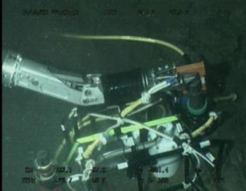
6 3. DIVE RESULTS We carried out twelve dives (Dive #1194 through Dive #1204) in total with ROV Hyper-Dolphin during our present NT10-18 cruise. Summary of each dive are summarized as follows, (1) Dive #1194 on 05 October We planned to do cable lay between the node A and the observatory A-2, but ROV had a minor problem right after the dive. Therefore this dive was cancelled on the way of the dive. Photo 1. ROV with extension cable laying system


7 (2) Dive #1195 on 05 October After fix the ROV minor problems occurred on the #1194 dive, we tried to do extension cable laying operation again. But we found that the cable drum attached with ROV had a bit problem. The problems is what is cable drum keeps free wheel condition and unexpected cable payout causing twining around the drum shaft during the dive due to the water current. This dive was also cancelled and we made an attachment to fix the cable drum rotation during diving down till the ocean bottom. Photo 2. Unexpected cable drum rotation during Dive #1195 Photo 3. An attachment for cable drum stopper


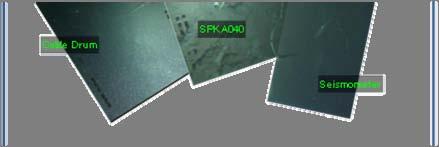
8 (3) Dive #1196 on 06 October We could prevent unexpected rotation of the cable drum during the diving down in terms of the stopper. We successfully carried out extension cable laying operation with no trouble between Node A and the observatory A km extension cable laying operation was done during the current dive with 11 hours dive. After connecting to sensor package, cable communication regarding the observatory A-2 is confirmed to be good from Furue landing station. The node connector is used at No.1 port of Node A, and the extension cable is used with No.9 cable colored by black. The location and sensor IDs of observatory A-2 are as follows, N, E, 2011m, Sensor ID: SPKG A040 Photo 4. Cable connection to the node A Photo 5. Cable drum near the observatory A-2


9 Photo 6 Cable connection to the sensor package Photo 7 Sensor layout at observatory A-2


10 (4) Dive #1197 on 07 October We planned to carry out extension cable laying operation between Node A and observatory A-4. We connected interface of the extension cable to No.8 port at Node A, then right after laying extension cable, we had an accident to take place a kink, i.e., an abnormal loop on the extension cable. Our operation had to suspend and we decided to go back. This is because we could not check the status at that time, so we decided to recover the extension cable. After recovering the extension cable, we checked the cable had not been damaged physically at all. Both the optical fiber liens and power feeding copper lines are well worked on the board. We judged that this extension cable was reusable in the next operation. We changed the procedure to lay extension cable near at the beginning of operation. Photo 8 Kink occurred in the extension cable Photo 9 Extension cable laying at the beginning (left: until Dive #1197, right: now)


11 (5) Dive #1198 on 10 October Hyper-Dolphin Dives on 08 and 09 October were cancelled due to the bad weather. On 10 October, we carried out backfilling operation at observatory A-2 by using Sand Feeder newly designed by Dr. Yokobiki. It took a few minutes to complete the seismic sensor package filled by sand. It made us possible to short operation time to complete backfilling. Photo 10 Sand Feeder equipped with Hyper-Dolphin Photo 11 Seismic sensor package in the burial hole (left: before backfilling operation, right: after operation)


12 (6) Dive #1199 on 11 October We carried out extension cable laying operation between Node A and observatory A-4, which was approximately 9.5 km length. The observatory has been booted up after connecting the science cable to the sensor package. We checked the communication status well. The node connector is used at No.8 port of Node A, and the extension cable is used with No.8 cable colored by white. The location and sensor IDs of observatory A-4 are as follows, N, E, 2054m, Sensor ID: SPKG A080 Photo 12 Extension cable interface connecting to No.8 port of Node A Photo 13 Extension cable laying operation by Hyper-Dolphin


13 Photo 14 Other side interface connecting to the sensor package Photo 15 Sensor layout of observatory A-4

14 (7) Dive #1200 on 12 October Extension cable laying operation between Node E and observatory E-17 was completed, and booting up of the observatory was performed in this commemorative dive. After connecting science cable, both the node E and the observatory E-17 have been booted, and we made sure the communication is well. We have laid the science cable in approximately 9.0 km long. The node connector is used at No.7 port of Node E, and the extension cable is used with No.11 cable colored by blue. The location and sensor IDs of observatory E-17 are as follows, N, E, 2054m, Sensor ID: SPKG A060 Photo 16 Extension cable interface connecting to No. 7 port of Node E


15 Photo 17 Other side interface connecting to the sensor package Photo 18 Sensor layout of observatory E-17


16 (8) Dive #1201 on 13 October We carried out burial hole conditioning by using the suction system named DROTHY and tried to install the seismic sensor package into the burial hole at observatory D-16. After conditioning the burial hole, we realized that the seismic sensor package could not be deployed into the hole smoothly. Therefore, we left the seismic sensor package at the bottom, and we would recover another day. We discussed this phenomenon on board, and we considered two reasons; one is sediment is still left inside the hole, and the other is two different diameters holes does not coincident with each other. At last, we would try to do hole conditioning and watch the status inside the hole carefully. Photo 19 Burial hole conditioning using by DROTHY Photo 20 Sensor installation into the burial hole

17 Photo 21 Sensor package installation not perfectly


18 (9) Dive #1202 on 14 October We planned to recover seismic sensor package left in previous Dive #1201. We recovered the seismic sensor package from the burial hole at first. And we checked the condition inside the hole, and we did make the hole adjustment again. The hole condition became better than the originals after adjustment, we put the seismic sensor package into the hole again and put the pressure sensor package. As a result, we did not recover the sensor, and we successfully installed the sensor at observatory D-16. The location, ROV-Homer ID, and sensor IDs of observatory D-16 are as follows, N, E, 1970m, Homer-ID: 13, Sensor ID: SPKG A090 Photo 22 Seismic sensor package installation at D-16 Photo 23 Pressure sensor package (SPKG A090) installation near the burial hole


19 (10) Dive #1203 on 15 October We performed burial hole conditioning at the observatory E-19 by using DROTHY. Although burial length of the casing somewhat seems not to be enough for sensor installation, i.e., 50 cm rising up from the bottom, we carried out conditioning inside the casing. We need to discuss that we use this casing or we will install new one instead. The location measured by Dive #1203 and ROV-Homer ID of observatory E-19 are as follows, N, E, 1908m, Homer-ID:23 Photo 24 Burial hole conditioning at E-19 Photo 25 View of burial hole after conditioning by DROTHY


20 (11) Dive #1204 on 15 October After conditioning the burial hole at observatory E-19, we continue to do same operation at observatory E-18. The bottom casing at E-18a has been installed in a good condition, and we have put the cover designed by Mr. Kodera on it. The location measured by Dive #1204 and ROV-Homer ID of observatory E-18 are as follows, N, E, 2048m, Homer-ID:31 Photo 26 Burial hole conditioning at E-18 Photo 27 Cover put on the burial hole


21 (12) Dive 1205 on 16 October This was the last dive of the present NT10-18 cruise. We carried out the burial hole conditioning at observatory B-6 by using DROTHY. After adjustment, we put cover on the bottom casing as done at observatory E-18. The location measured by Dive #1205 and ROV-Homer ID of observatory B-6 are as follows, N, E, 2496m, Homer-ID:90 Photo 28 Burial hole conditioning at B-6 Photo 29 Cover put on the burial hole
22 4. CONCLUSIONS In the present NT10-18 cruise, three new observatories were able to be activated, one candidate observatory was installed and three candidate sites were conditioned. This is a very excellent result for DONET project. We can expect several more observatories activation in the forthcoming cruise scheduled Dec to Jan End of Report.
KY10-15 KAIYO / HYPER-DOLPHIN
 KY10-15 KAIYO / HYPER-DOLPHIN Kumano-Nada January 2011 Earthquake and Tsunami Research Project for Disaster Prevention JAMSTEC TABLE OF CONTENTS 1. INTRODUCTION 2. SCHEDULE 3. DIVE RESULTS 4. CONCLUSIONS
KAIYO Cruise Report. KY15-05Leg2. Construction of DONET2 system. Off Kii Channel. Kumano-nada. March.12 March.29, 2015
 KAIYO Cruise Report KY15-05Leg2 Construction of DONET2 system Off Kii Channel Kumano-nada March.12 March.29, 2015 Japan Agency for Marine-Earth Science and Technology (JAMSTEC) Contents 1. Cruise Information...
KAIYO CRUISE REPORT. KY15-16 Leg1
 KAIYO CRUISE REPORT KY15-16 Leg1 Construction of DONET2 Off Kii Channel Oct.16,2015-Nov.6,2015 Japan Agency for Marine-Earth Science and Technology (JAMSTEC) 1 Contents 1. Cruise Information -----------------------------------------
NT09-21 Cruise Report SURUGA-BAY Cable Laying Experiment / VBCS Function Test
 NT09-21 Cruise Report SURUGA-BAY Cable Laying Experiment / VBCS Function Test December 2009 Table of Contents 1. Overview 2. Schedule 3. Dive Summary 4. Concluding Remarks 1. Overview A unique development
1. On site calibration of a pressure gage using a mobile. 2. Temporal variation of Rn emanation at faults
 R/V Natsushima Cruise Report NT14-13 Title of the cruise 1. On site calibration of a pressure gage using a mobile pressure sensor 2. Temporal variation of Rn emanation at faults survey area: off Kumano-nada
R/V Natsushima Cruise Report NT15-21
 R/V Natsushima Cruise Report NT15-21 Survery for SIP cable observation system Off Izu-Oshima Dec.8,2015-Dec.16,2015 Japan Agency for Marine-Earth Science and Technology (JAMSTEC) Contents 1. Cruise Information
R/V Natsushima Cruise Report NT Title of the cruise. Boso Peninsula and development of in situ calibration for. DONET pressure gauge
 R/V Natsushima Cruise Report NT15-12 Title of the cruise Deploy and retrieval of ocean bottom instruments at off Boso Peninsula and development of in situ calibration for DONET pressure gauge July15,2015-July
Ocean Observatories Initiative Cabled Array Observatory Extension Cables/Connectors
 Ocean Observatories Initiative Cabled Array Observatory Extension Cables/Connectors Mike Harrington mikeh@apl.washington.edu Infrastructure Cable Laying Problem: Get to the interesting stuff. Laying interconnection
Location: Barkley Canyon Date: September 9, 2013 Constraints: none
 Page 1 of 11 DIVE PLAN R1650 Location: Barkley Canyon Date: September 9, 2013 Constraints: none Objectives Deploy POD 1 autonomous CTD Survey POD 3 for sediment enrichment sites; deposit cages; collect
SEISMIC SHUTOFF CHARACTERISTICS OF INTELLIGENT GAS METERS FOR INDIVIDUAL CUSTOMERS IN JAPAN
 The Tenth East Asia-Pacific Conference on Structural Engineering and Construction August 3-5, 26, Bangkok, Thailand SEISMIC SHUTOFF CHARACTERISTICS OF INTELLIGENT GAS METERS FOR INDIVIDUAL CUSTOMERS IN
Natsushima Cruise Report NT Sea trial of Autonomous Underwater Vehicle. Yumeiruka around Omuro-dashi. Sagami Bay, Suruga Bay and Omuro-dashi
 Natsushima Cruise Report NT15-11 Sea trial of Autonomous Underwater Vehicle Yumeiruka around Omuro-dashi Sagami Bay, Suruga Bay and Omuro-dashi July 5, 2015 July 10, 2015 Japan Agency for Marine-Earth
Mitsui Engineering & Shipbuilding Co., LTD. Kenji NAGAHASHI
 Mitsui Engineering & Shipbuilding Co., LTD. Kenji NAGAHASHI kenji_nagahashi@mes.co.jp Contents 1. Underwater Robots produced by MES 2. Future Concept 2 Image of Underwater Works Research Vessel Communication
Protection for Vessels Engaged in Servicing Submarine Cables
 Protection for Vessels Engaged in Servicing Submarine Cables Proposed Amendments to COLREGS Brief to Navigation Safety Advisory Council November 28, 2012 Tampa, FL Dr. Ronald J. Rapp TE SubCom and Representing
Survey design and acquisition of a 4-C ocean-bottom seismometer survey over the White Rose oilfield, offshore Newfoundland
 White Rose OBS, 2002 Survey design and acquisition of a 4-C ocean-bottom seismometer survey over the White Rose oilfield, offshore Newfoundland Kevin W. Hall and Robert R. Stewart ABSTRACT CREWES, in conjunction
Onboard Report. off Tohoku (NT13-21LEG1)
") Onboard Report of the ROV Hyper-Dolphin 3000 Cruise off Tohoku (NT13-21LEG1) October 6 19, 2013 Japan Agency for Marine-Earth Science and Technology (JAMSTEC) Cruise ID: NT13-21LEG1 Name of vessel: R/V
Onboard Report of the ROV Hyper-Dolphin 3000 Cruise off Tohoku (NT13-21LEG1) October 6 19, 2013 Japan Agency for Marine-Earth Science and Technology (JAMSTEC) Cruise ID: NT13-21LEG1 Name of vessel: R/V
SCIENCE OF TSUNAMI HAZARDS
 SCIENCE OF TSUNAMI HAZARDS ISSN 8755-6839 Journal of Tsunami Society International Volume 31 Number 2 2012 SEA LEVEL SIGNALS CORRECTION FOR THE 2011 TOHOKU TSUNAMI A. Annunziato 1 1 Joint Research Centre,
Prologue. TSUNAMI - To Survive from Tsunami World Scientific Publishing Co. Pte. Ltd.
 Prologue The Indian Ocean tsunami which occurred on December 26, 2004 caused unprecedented disaster and claimed the priceless lives of more than 300,000 persons worldwide. Among the conditions which contributed
AN OFFSHORE TIDE GAUGE
 AN OFFSHORE TIDE GAUGE by Toshio Y a m a d a and Kinji I w a d a Hydrographic Department of Japan 1. INTRODUCTION Between October and December 1970 the Hydrographic Department of Japan carried out jointly
Ocean Observatories Initiative (OOI) Moorings: New Capabilities for Seagoing Science
 Moorings: New Capabilities for Seagoing Science") Ocean Observatories Initiative Ocean Observatories Initiative (OOI) Moorings: New Capabilities for Seagoing Science presented by Ed Dever and Walt Waldorf November 20, 2014 OOI Science Themes Coastal and
Ocean Observatories Initiative Ocean Observatories Initiative (OOI) Moorings: New Capabilities for Seagoing Science presented by Ed Dever and Walt Waldorf November 20, 2014 OOI Science Themes Coastal and
A New Generator for Tsunami Wave Generation
 Journal of Energy and Power Engineering 10 (2016) 166-172 doi: 10.17265/1934-8975/2016.03.004 D DAVID PUBLISHING Tetsuya Hiraishi 1, Ryokei Azuma 1, Nobuhito Mori 2, Toshihiro Yasuda 2 and Hajime Mase
In Activity 36, Storing Waste, you evaluated Yucca Mountain,
 49 Comparing Site Risk TA L K I N G I T O V E R In Activity 36, Storing Waste, you evaluated Yucca Mountain, Nevada as a site for storing nuclear waste. The U.S. Congress considered several other sites
Yokosuka Cruise Report YK11-02
 Yokosuka Cruise Report YK11-02 Sea Trial of The HETL Fuel Cell System for Underwater Platform JAMSTEC ~ Sagami-Bay ~ JAMSTEC March 6, 2011 ~ March 9, 2011 Japan Agency for Marine-Earth Science and Technology
Development of 7,000m Class ROV KAIKO7000
 Development of 7,000m Class ROV KAIKO7000 H. Sezoko*, T. Murashima*, H. Nakajyoh*, H. Yoshida*, N. Yamauchi** * Research Support Department (RSD), Marine Technology Center (MARITEC) Japan Agency for Marine-Earth
Heating of Land and Water. Evaluation copy. lamp with a 100 W (or greater) bulb. 2 Temperature Probes 2 one-hole stoppers 2 pans beaker.
 bulb. 2 Temperature Probes 2 one-hole stoppers 2 pans beaker.") Name Date Heating of Land and Water Computer 2 How fast land and water heat and cool influences our weather. In Part I of this experiment, you will heat sand and water. You will use two Temperature Probes
Name Date Heating of Land and Water Computer 2 How fast land and water heat and cool influences our weather. In Part I of this experiment, you will heat sand and water. You will use two Temperature Probes
NSF's Ocean Observatories Initiative: Building Research Infrastructure for the Pacific Northwest and the Broader Community
 Agenda Item B.3.b Supplemental OOI PowerPoint April 2013 Ocean Observatories Initiative NSF's Ocean Observatories Initiative: Building Research Infrastructure for the Pacific Northwest and the Broader
JAMSTEC trial of 11,000m UROV
 JAMSTEC trial of 11,000m UROV Representative : Kikuo Hashimot (Director) Presenting : Hidehiko Nakajoh Japan Agency for Marine Earth Science and Technology ( JAMSTEC ) 2-15 Natsushima-cho Yokosuka, Japan
Heating of Land and Water
 Heating of Land and Water Experiment 8 How fast land and water heat and cool influences our weather. In Part I of this experiment, you will heat sand and water. You will use two Temperature Probes to see
Protected Microducts, Overview and Current Trends
 Draka Comteq Netherlands / Comparison of Microduct Types for optical cables installation Protected Microducts, Overview and Current Trends W. Griffioen 1, W. Greven 2 1 Draka Comteq Cable Solutions, Amsterdam,
Isis Deployment. TMS and Live Boating. Inmartech08. Dave Turner Operations Co-ordinator.
 Isis Deployment TMS and Live Boating Inmartech08 Dave Turner Operations Co-ordinator TMS Operations Why Why do do we we have have aa TMS? TMS? ItIt was was deemed deemed an an essential essential part
Utilizing Vessel Based Mobile LiDAR & Bathymetry Survey Techniques for Survey of Four Southern California Breakwaters
 Utilizing Vessel Based Mobile LiDAR & Bathymetry Survey Techniques for Survey of Four Southern California Breakwaters Western Dredging Association: Pacific Chapter September 2012 Insert: Pipe Location
SODV - PAC REACTION PAPER SUBSEA VISUALIZATION SYSTEMS
 SODV - PAC REACTION PAPER SUBSEA VISUALIZATION SYSTEMS Prepared by David Christie for PAC Past and Future The predominant and essential requirement of subsea visualization in support of drilling operations
Alvin Debrief Summary Seven Cruises for 91 dives. Southern California Juan de Fuca Costa Rica Guaymas Basin Galapagos
 Seven Cruises for 91 dives Southern California Juan de Fuca Costa Rica Guaymas Basin Galapagos Overview All the PIs were very satisfied with their Alvin experience and felt that their scientific goals
AA AIRCRAFT ACCIDENT INVESTIGATION REPORT. Setouchi SEAPLANES Inc. J A 0 2 T G
 AA2018-2 AIRCRAFT ACCIDENT INVESTIGATION REPORT Setouchi SEAPLANES Inc. J A 0 2 T G February 22, 2018 The objective of the investigation conducted by the Japan Transport Safety Board in accordance with
DTC P0441 Evaporative Emission Control System Incorrect. DTC P0446 Evaporative Emission Control System Vent Control Malfunction
 DI90 IN (2RZF, 3RZF) DI17A04 DTC P0441 vaporative mission Control System Incorrect Purge Flow DTC P0446 vaporative mission Control System Vent Control Malfunction CIRCUIT DSCRIPTI The vapor pressure sensor
Sensor Platform Project Marine Trials Bidders Conference. Fundy Ocean Research Center for Energy fundyforce.ca
 Sensor Platform Project Marine Trials Bidders Conference Fundy Ocean Research Center for Energy fundyforce.ca 1 Project Team FORCE OceanWorks International Preliminary Design, Operational Procedures Murray
OCN 201 Tides. Tsunamis, Tides and other long waves
 OCN 201 Tides Tsunamis, Tides and other long waves Storm surges Caused by winds and low atmospheric pressure associated with large storms Can raise sea surface by up to 25 ft, bottom contours magnify effect
Marine Mammal Acoustic Tracking from Adapting HARP Technologies
 DISTRIBUTION STATEMENT A: Approved for public release; distribution is unlimited. Marine Mammal Acoustic Tracking from Adapting HARP Technologies Sean M. Wiggins and John A. Hildebrand Marine Physical
What are Waves? Earthquake. Waving flags. Vocal Cords Vibrate
 Waves Ch. 10 What are Waves? All waves are movement of energy through a medium (air, rock, water) Series of vibrations or undulations in a medium Wave types: ocean, sound, light, seismic Vocal Cords Vibrate
Compiled by Uwe Dornbusch. Edited by Cherith Moses
 REPORT ON WAVE AND TIDE MEASUREMENTS Compiled by Uwe Dornbusch. Edited by Cherith Moses 1 Aims...1 2 Summary...1 3 Introduction...1 4 Site selection...1 5 Wave recorder settings...2 6 Results...2 6.1 Water
Understanding the Tsunami Wave
 The First Tsunami attack on Sri Lanka Krakatoa Island 27 th August 1883 Understanding the Tsunami Wave Generation Propagation Nearshore Transformation Shoreline Entry Inland Dissipation 1 Generation and
NEAMTWS and its current developments
 NEAMTWS and its current developments 13th Eastern Atlantic Hydrographic Commission (EAtHC) of IHO Casablanca, 16-18 September 2014 Francesca Santoro Head of the Technical Secretariat for the NEAMTWS (IOC-UNESCO)
Seismic Survey Designs for Converted Waves
 Seismic Survey Designs for Converted Waves James A. Musser* GMG/AXIS Inc., Denver, CO 1720 Red Cloud Road, Longmont, CO, 80501, USA jmusser@gmg.com ABSTRACT Designing converted wave 3D surveys is considerably
ISE Subsea Tools and Toolsleds
 1734 Broadway St. Port Coquitlam, B.C. V3C 2M8, Canada +1.604.942.5223 +1.604.942.7577 info@ise.bc.ca www.ise.bc.ca ISE Subsea Tools and Toolsleds 1 INTRODUCTION The value of an ROV is increased by its
BEACH NOURISHMENT BY RAINBOWING FOR THE VISAKHAPATNAM PORT TRUST BY DCI. Capt. MVR MURTHY ABSTRACT
 BEACH NOURISHMENT BY RAINBOWING FOR THE VISAKHAPATNAM PORT TRUST BY DCI Capt. MVR MURTHY ABSTRACT The coastal city of Visakhapatnam had a long wide beach. Over past three decades, this beach has progressively
WIND SPEED LENGTH OF TIME WIND BLOWS (Duration) DISTANCE OVER WHICH IT BLOWS (Fetch)
 DISTANCE OVER WHICH IT BLOWS (Fetch)") WAVES Up and down movement of ocean surface Transportation of energy across the water over vast distances If not stopped by anything, waves can travel entire oceans Size and speed depend upon: WIND SPEED
WAVES Up and down movement of ocean surface Transportation of energy across the water over vast distances If not stopped by anything, waves can travel entire oceans Size and speed depend upon: WIND SPEED
How deep does an anchor penetrate the seafloor?
 6 th Workshop Seabed Acoustics, Rostock, November 14/15, 213 P3-1 How deep does an anchor penetrate the seafloor? Christian Maushake Federal Waterways Engineering and Research Institute Coastal Department
Digiquartz Water-Balanced Pressure Sensors for AUV, ROV, and other Moving Underwater Applications
 Digiquartz Water-Balanced Pressure Sensors for AUV, ROV, and other Moving Underwater Applications Dr. Theo Schaad Principal Scientist Paroscientific, Inc. 2002 Paroscientific, Inc. Page 1 of 6 Digiquartz
1.0 PURPOSE AND NEED
 1.0 PURPOSE AND NEED 1.0 PURPOSE OF AND NEED FOR THE PROPOSED ACTION 1.1 INTRODUCTION The National Environmental Policy Act (NEPA) of 1969, as amended (42 United States Code Section 4321 et seq.); the
STUDY ON TSUNAMI PROPAGATION INTO RIVERS
 ABSTRACT STUDY ON TSUNAMI PROPAGATION INTO RIVERS Min Roh 1, Xuan Tinh Nguyen 2, Hitoshi Tanaka 3 When tsunami wave propagation from the narrow river mouth, water surface is raised and fluctuated by long
Noise Experiment #2. Marine Physical Laboratory Scripps Institution of Oceanography La Jolla, CA February 22 February 2010
 Noise Experiment #2 Marine Physical Laboratory Scripps Institution of Oceanography La Jolla, CA 92093-0701 16 February 22 February 2010 1. Objective The objective of the noise experiment is to observe
BASIC Z-STACK AND TIME SERIES SCAN ON THE ZEISS LIGHTSHEET Z. 1
 BASIC Z-STACK AND TIME SERIES SCAN ON THE ZEISS LIGHTSHEET Z. 1 The front door of the main body of the instrument may be open when you arrive. Take the sample chamber and slide it into position with the
ALOHA CABLED OBSERVATORY. PHASE 2 Installation Cruise. Preliminary Report. Fred Duennebier, David Harris, James Jolly. November 2, Rev.
 ALOHA CABLED OBSERVATORY PHASE 2 Installation Cruise Preliminary Report Fred Duennebier, David Harris, James Jolly November 2, 2008 Rev. 2 ACO Report page 1 of 10 Summary: The purpose of cruise TGT 226,
Sentry de-brief summaries 2011/2012
 Three cruises*: 1 Sentry/TowCam 1 Sentry/TowMag 1 Sentry/Jason *All cruises were post-refit 1 Pre-Cruise Planning: For two cruises everything was fine and went well For 1 cruise - planning began just one
UNDERWATER SERVICES COMPANY PROFILE
 UNDERWATER SERVICES COMPANY PROFILE irov Underwater Services is an Italian Independent H i g h l y S p e c i a l i z e d C o m p a n y p r o v i d i n g underwater technology and ROV assistance to Salvage
APPLICATIONS ROV & AUV SEISMIC PRODUCTION SYSTEMS DOWNHOLE JUMPER & CABLE SYSTEMS DRILLING CONTROL
 APPLICATIONS ROV & AUV SEISMIC PRODUCTION SYSTEMS DOWNHOLE JUMPER & CABLE SYSTEMS DRILLING CONTROL ROV & AUV PRODUCTS GRE (Glass Reinforced Epoxy) CS-MS 55 & 66 SERIES MINI-CON HUMMER GLOBE-CON ALL-WET
Scottish Hydro Electric Power Distribution Operation, Inspection, Maintenance and Decommissioning Strategy Bute Cumbrae Cable Replacement
 SHEPD Section ID 154 Scottish Hydro Electric Power Distribution Operation, Inspection, Maintenance and Decommissioning Strategy Bute Cumbrae Cable Replacement Contents Definitions and Abbreviations...
DEVELOPMENT OF TSUNAMI REFUGE PETRI-NET SIMULATION SYSTEM UTILIZABLE IN INDEPENDENCE DISASTER PREVENTION ORGANIZATION
 DEVELOPMENT OF TSUNAMI REFUGE PETRI-NET SIMULATION SYSTEM UTILIZABLE IN INDEPENDENCE DISASTER PREVENTION ORGANIZATION Takashi Minamoto 1, Yoshifumi Nariyuki 2, Yasuhiro Fujiwara 1 and Atsushi Mikami 3
DIVE PLAN Leg 1 Dive 11 Recover Wally 1
 DIVE PLAN Leg 1 Dive 11 Recover Wally 1 Page 1 of 6 Location: Barkley Canyon Date: 9 May, 2014 14:00 Constraints: Weather, Sufficient deck space ROV Dive # OE 114 Objectives Prepare Wally I cable for recovery
Full STEAM Ahead: Waves. Version 1 25 April 2018
 Full STEAM Ahead: Waves Version 1 25 April 2018 Full STEAM Ahead! Welcome to Full STEAM Ahead! Today you will be experimenting with the physics of waves. This is a directed and self-directed, self-paced
Potential applications of AUVs and Gliders in Offshore Windfarm Site Surveys
 Potential applications of AUVs and Gliders in Offshore Windfarm Site Surveys Dr James Hunt (National Oceanography Centre, Southampton) MREKE Internship in partnership with MARS at NOCS Introduction to
TSUNAMI WARNINGS - A GUIDE FOR MEDIA - August 2018
 TSUNAMI WARNINGS - A GUIDE FOR MEDIA - August 2018 Tsunami that affect New Zealand may be generated on, near, or far from our shores. New Zealand is at risk from tsunami that happen near us, and around
Pioneer Array Micro-siting Public Input Process Frequently Asked Questions
 Pioneer Array Micro-siting Public Input Process Frequently Asked Questions The National Science Foundation (NSF) has completed the micro-siting of the moored array of the Ocean Observatories Initiative
The Next Generation Easy-to-Deploy (ETD) Tsunami Assessment Buoy
 Tsunami Assessment Buoy") The Next Generation Easy-to-Deploy (ETD) Tsunami Assessment Buoy R.A. Lawson and D. Graham Science Applications International Corporation 4025 Hancock Street San Diego, CA 92110 USA S. Stalin, C. Meinig,
The Next Generation Easy-to-Deploy (ETD) Tsunami Assessment Buoy R.A. Lawson and D. Graham Science Applications International Corporation 4025 Hancock Street San Diego, CA 92110 USA S. Stalin, C. Meinig,
WHAT IS A TSUNAMI? happens.nz. Long or Strong GET GONE TSUNAMI 101
 WHAT IS A TSUNAMI? A tsunami is a series of powerful waves with strong currents. They are mostly caused by underwater or coastal earthquakes, and sometimes by underwater landslides or volcanic eruptions.
Original URI Scanfish MKII
 Scanfish MKII URI s Scanfish MKII Sensors include CTD, Fluorometer, Dissolved Oxygen and Seabird Fast Temperature and Conductivity Sensors logging at 400 Hz and sending 50 Hz data via 9600 Baud uplink
Name: Unit 5-6 Pretest. 28. Circle the picture(s) that show erosion.
 that show erosion.") Name: 28. Circle the picture(s) that show erosion. ATEP 2009 UAF Geophysical Institute 10 29. Write or draw what a ghost forest is. soil 30. These are layers from the soil. Circle the oldest layer. sand
Name: 28. Circle the picture(s) that show erosion. ATEP 2009 UAF Geophysical Institute 10 29. Write or draw what a ghost forest is. soil 30. These are layers from the soil. Circle the oldest layer. sand
Authors: James P. Barry*, Chris Lovera, Kurt R. Buck, Edward T. Peltzer, Josi R. Taylor, Peter
 SUPPORTING INFORMATION Authors: James P. Barry*, Chris Lovera, Kurt R. Buck, Edward T. Peltzer, Josi R. Taylor, Peter Walz, Patrick J. Whaling, Peter G. Brewer, Affiliation: Monterey Bay Aquarium Research
A process based approach to understand WA s complex coastline Jeff Hansen Ryan Lowe Graham Symonds Laura Segura Gundula Winter
 A process based approach to understand WA s complex coastline Jeff Hansen Ryan Lowe Graham Symonds Laura Segura Gundula Winter WA s coastline is highly variable due to offshore and shore-attached coral
Geology 10 Activity 8 A Tsunami
 Geology 10 Activity 8 A Materials: Marigram recorded in San Diego, May 23, 1960. Travel Time Graph To San Diego. Answer sheet Source of information: Lander, James F., Patricia A. Lockridge and Michael
LABORATORY STUDY ON TSUNAMI REDUCTION EFFECT OF TEIZAN CANAL
 Proceedings of the 6 th International Conference on the Application of Physical Modelling in Coastal and Port Engineering and Science (Coastlab16) Ottawa, Canada, May 10-13, 2016 Copyright : Creative Commons
The leakages on the water pipes
 The leakages on the water pipes Korea has lost almost 3 billion USD for 5 years due to water pipes leaks. It also has safety issue. They can make big sink holes and it will be threat of civil safety. This
Homework 2 Bathymetric Charts [based on the Chauffe & Jefferies (2007)]
![Homework 2 Bathymetric Charts [based on the Chauffe & Jefferies (2007)]](/thumbs/75/72427079.jpg "Homework 2 Bathymetric Charts [based on the Chauffe & Jefferies (2007)]") 1 MAR 110 HW-2 - Bathy Charts Homework 2 Bathymetric Charts [based on the Chauffe & Jefferies (2007)] 2-1. BATHYMETRIC CHARTS Bathymetric charts are maps of a region of the ocean used primarily for navigation
1 MAR 110 HW-2 - Bathy Charts Homework 2 Bathymetric Charts [based on the Chauffe & Jefferies (2007)] 2-1. BATHYMETRIC CHARTS Bathymetric charts are maps of a region of the ocean used primarily for navigation
Depth sensor. Product reference : REV 1. USER GUIDE and INSTALLATION GUIDE. nke Sailing competition
 Depth sensor Product reference : 90-60-456 REV 1 USER GUIDE and INSTALLATION GUIDE nke Sailing competition Z.I. Kerandré Rue Gutenberg 56700 HENNEBONT- FRANCE http://www.nke.fr After sale service n 33
DEPARTMENT OF THE NAVY DIVISION NEWPORT OFFICE OF COUNSEL PHONE: FAX: DSN:
 IMAVSBA WARFARE CENTERS NEWPORT DEPARTMENT OF THE NAVY NAVAL UNDERSEA WARFARE CENTER DIVISION NEWPORT OFFICE OF COUNSEL PHONE: 401 832-3653 FAX: 401 832-4432 DSN: 432-3653 Attorney Docket No. 85031 Date:
Yasuyuki Hirose 1. Abstract
 Study on Tsunami force for PC box girder Yasuyuki Hirose 1 Abstract In this study, a waterway experiment was performed in order to understand the influence of tsunami forms on tsunami forces acting on
Presentation to : Marine Aquaculture Task Force 2006
 Presentation to : Marine Aquaculture Task Force 2006 January 19th, 2006 Kona Kampachi Development of the first hatch-to-harvest open ocean fish farm in the U.S. Presentation by: Neil Anthony Sims, M.Sc.
Underwater Robots Jenny Gabel
 Underwater Robots Jenny Gabel 06.01.2014 Table of Contens Introduction Challenges of Underwater Exploration Remotely Operated Vehicles Autonomous Underwater Vehilces Future Perspectives References 2 Introduction
Geology 15 Activity 5 A Tsunami
 Materials: Marigram recorded in San Diego, May 23, 1960. Travel Time Graph To San Diego. Answer sheet Source of information: Lander, James F., Patricia A. Lockridge and Michael J. Kozuch, s Affecting the
SCIENTIFIC COMMITTEE SEVENTH REGULAR SESSION August 2011 Pohnpei, Federated States of Micronesia
 SCIENTIFIC COMMITTEE SEVENTH REGULAR SESSION 9-17 August 2011 Pohnpei, Federated States of Micronesia CPUE of skipjack for the Japanese offshore pole and line using GPS and catch data WCPFC-SC7-2011/SA-WP-09
Proof of Concept Demonstration of the Hybrid Remotely Operated Vehicle (HROV) Light Fiber Tether System
 Light Fiber Tether System") Proof of Concept Demonstration of the Hybrid Remotely Operated Vehicle (HROV) Light Fiber Tether System Barbara Fletcher Chris Young James Buescher Space and Naval Warfare Systems Center San Diego, CA
Proof of Concept Demonstration of the Hybrid Remotely Operated Vehicle (HROV) Light Fiber Tether System Barbara Fletcher Chris Young James Buescher Space and Naval Warfare Systems Center San Diego, CA
Pre-Trenching, Pre-Sweeping and Backfilling for the 36 Offshore Pipeline Project in Taiwan
 Edward van Melkebeek Pre-Trenching, Pre-Sweeping and Backfilling for the 36 Offshore Pipeline Project in Taiwan Abstract The advantages of a trailing suction hopper dredger for a pipeline trenching job
Dynamic Positioning: Method for Disaster Prevention and Risk Management
 Available online at www.sciencedirect.com ScienceDirect Procedia Earth and Planetary Science 11 ( 2015 ) 216 223 Global Challenges, Policy Framework & Sustainable Development for Mining of Mineral and
13. TIDES Tidal waters
 Water levels vary in tidal and non-tidal waters: sailors should be aware that the depths shown on the charts do not always represent the actual amount of water under the boat. 13.1 Tidal waters In tidal
Nemo Link s puxo campaign
 BLOCK 3 BLOCK 2 U e c n France 400000 570000 KP 0 KP 10 KP 20 KP 30 a r F 565000 BLOCK 1 450000 Belgique 0 5 ONGOING 10 15 20 km N 565000 t i n g n i K Nearshore BE Fra m o d ed KP 50 KP 60 KP 70 KP 80
STUDY OF UNDERWATER THRUSTER (UT) FRONT COVER OF MSI300 AUTONOMOUS UNDERWATER VEHICLE (AUV) USING FINITE ELEMENT ANALYSIS (FEA)
 FRONT COVER OF MSI300 AUTONOMOUS UNDERWATER VEHICLE (AUV) USING FINITE ELEMENT ANALYSIS (FEA)") STUDY OF UNDERWATER THRUSTER (UT) FRONT COVER OF MSI300 AUTONOMOUS UNDERWATER VEHICLE (AUV) USING FINITE ELEMENT ANALYSIS (FEA) M. Sabri 1, 2, T. Ahmad 1, M. F. M. A. Majid 1 and A. B. Muhamad Husaini
STUDY OF UNDERWATER THRUSTER (UT) FRONT COVER OF MSI300 AUTONOMOUS UNDERWATER VEHICLE (AUV) USING FINITE ELEMENT ANALYSIS (FEA) M. Sabri 1, 2, T. Ahmad 1, M. F. M. A. Majid 1 and A. B. Muhamad Husaini
Chapter 9: Sea operations
 Chapter 9: Sea operations ANTARES takes advice from IFREMER for the sea operations, which concern the installation and recovery of the different components of the detector : Junction Box, Strings, Interconnecting
How To Enter Kushiro Port and Things To Be Aware of When Entering
 How To Enter Kushiro Port and Things To Be Aware of When Entering 1.How to enter Kushiro Port (1)How to enter the East Area When entering the port from Nemuro, navigate while maintaining a safe distance
Waves, Bubbles, Noise, and Underwater Communications
 Waves, Bubbles, Noise, and Underwater Communications Grant B. Deane Marine Physical Laboratory, Scripps Institution of Oceanography UCSD, La Jolla, CA 92093-0238 phone: (858) 534-0536 fax: (858) 534-7641
Wave Glider: Liege Colloquium. Colloquium April 27
 The The Wave Wave Glider: Glider: Enabling Enabling aa New New Approach Approach to to Persistent Persistent Ocean Ocean Observation Observation and and Research Research nd Liege 42 42nd Liege Colloquium
For Educational and Non-Profit Use Only!
 This flyer was originally created and published in Japanese by Shizuoka Prefecture, Japan. UNESCO IOC ITIC provides this English translation for portions of the original document with the kind permission
A Study of the Normal Turbulence Model in IEC
 WIND ENGINEERING VOLUME 36, NO. 6, 212 PP 759-766 759 A Study of the Normal Turbulence Model in 614-1 Takeshi Ishihara *,1, Atsushi Yamaguchi *,2 and Muhammad Waheed Sarwar *,3 *1 Professor, Department
Hazard-Specific Annex Tsunami Annex Horry County, South Carolina
 Section 6-4 Hazard-Specific Tsunami Plan Hazard-Specific Annex Tsunami Annex Horry County, South Carolina 6-4 Hazard-Specific Tsunami Plan Comprehensive Emergency Management Plan Hazard Specific Annex
EMISSION CHAMBERS. Bulk and Surface Emission Detection for the RAD7 User Manual
 EMISSION CHAMBERS Bulk and Surface Emission Detection for the RAD7 User Manual TABLE OF CONTENTS INTRODUCTION 3 1 SYSTEM CONFIGURATION 4 1.1 Closed Loop Configuration 4 Fig. 1 Emission Chamber Closed Loop
KAIREI Cruise Report. KR17-11 Leg2
 KAIREI Cruise Report KR17-11 Leg2 Study of adaptive underwater Optical wireless communication with photomultiplier tube Suruga bay July 26 th, 2017 Japan Agency for Marine-Earth Science and Technology
Questions. Breaking Waves. Introduction to Oceanography
 Introduction to Oceanography Midterm 2: November 20 (Monday) Review session: Friday, Nov. 17 (TODAY!) 4:00-5:00pm in Franz 1260. Extra credit video screening: Monday, Nov. 20, 4:00-5:00pm in Royce 190.
Levelling A Practical Guide The process of Levelling explained
 2016 Levelling A Practical Guide The process of Levelling explained A practical guide aimed at land surveyors, engineers and archaeologists explaining the practice of levelling the process of determining
Real-Time Seismic Data from the Coastal Ocean
 Real-Time Seismic Data from the Coastal Ocean Daniel Frye 1, Uri ten Brink 2, Walter Paul 1, Kenneth Peal 1, Keith von der Heydt 1 dfrye@whoi.edu, utenbrink@usgs.gov, wpaul@whoi.edu, kpeal@whoi.edu, kvonderheydt@whoi.edu
Chapter 22, Section 1 - Ocean Currents. Section Objectives
 Chapter 22, Section 1 - Ocean Currents Section Objectives Intro Surface Currents Factors Affecting Ocean Currents Global Wind Belts (you should draw and label a diagram of the global wind belts) The Coriolis
Ocean Observing Systems Summer Teacher Institute August 10 August 14, 2009
 OOS? What s that?? COSEE-West 2008 Ocean Observing Systems Summer Teacher Institute Resources/Lesson Plans http://www.usc.edu/org/cosee-west/resources.html#aug08 Teacher created lesson plans from 2008
Waves. Types of Waves. Parts of a wave. Insert wind_wave.wmv. Shark attack
 Waves Recall: Waves = transmitted energy What causes waves? Wind gravity Earthquakes We will talk about all of these, but first Insert wind_wave.wmv Shark attack Types of Waves Body waves transmit energy