Click to edit Master title style Advanced Military Layers. and the Historic Environment
|
|
|
- Erick O’Connor’
- 5 years ago
- Views:
Transcription
1 Advanced Military Layers and the Historic Environment Paul Baggaley and Louise Tizzard Wessex Archaeology 1
2 Click to edit Objectives Master title style to establish the degree of mutual benefit in integrating AML and archaeological interpretations of seabed features; to develop compatibility in methodologies, data standards and metadata standards, covering: archaeological methodologies for discerning, discriminating and characterising seabed features; representation of seabed features as points and polygons at different scales; incorporation of digital imagery; accommodating copyright and licensing requirements; to develop good practice in reporting new and/or enhanced wreck data from archaeological sources to the UKHO; to develop good practice in preparing and submitting digital archives to recognised data centres. 2
3 WA Archaeological Assessments Government funded (research and commercial) Second level Heritage funded Commercial developers (EA and strategic) 3
4 Click Archaeological to edit Master Assessments title style MEDIN DAC Marine WA Project UKHO - AML DBA UKHO Wrecks Office Geophysical Acquisition and Processing UKHO - Hydrography Geophysical Assessment MCA Geotechnical Assessment COWRIE Diving and ROV Assessments Cultural Heritage OASIS NMR EH, CADW, RCAHMS Local authority HER ADS Project output Data output Data input 4
5 Archaeological Click to edit Master Assessments title style DBA Geophysical Assessment Phase 1 Phase 2 Phase 3 Discern Describe Output Group Discriminate Qualify Output Characterise Output Geotechnical assessment Diver and ROV survey 5
6 Click AML to product edit Master shapefiles title style Data Click coverage to edit Master shapefile text (polygon) styles CLB_Depth shapefile (point) Second level LBO_wrecks shapefile (point) LBO_wrecks Third level shapefile (polygon) LBO_sensor_anomaly Fourth level shapefile (point) ESB_Bottom_Feature Fifth level shapefile (point) ESB_Bottom_Feature shapefile (polygon) SBO_contact shapefile (point) SBO_viewpoint shapefile (point) 6
7 Commonalities between the AML products and the WA product AML Product AML Feature class WA investigation WA Product CLB/ESB/ LBO/SBO Data Coverage Geophysical assessment/ DBA /Underwater recording Survey area CLB Depth sounding Geophysical processing Depth data ESB Bottom feature Geophysical assessment Sandwave coverage ESB Bottom Feature Geophysical assessment Sub-set of Phase 2 Geophysics LBO Wreck DBA/ Geophysical assessment DBA gazetteer / Sub-set of Phase 2 Geophysics LBO Sensor anomaly Geophysical assessment Sub-set of Phase 2 Geophysics SBO Contact Geophysical assessment Sub-set of Phase 2 Geophysics SBO Viewpoint Underwater recording/ Geophysical assessment Stills Photography/data 7
8 Integration Click to edit of Master AML title projects style AML DBA LBO Geophysical Assessment Phase 1 Phase 2 Phase 3 CLB ESB LBO Discern Describe Output Group Discriminate Qualify Output ESB LBO SBO Characterise Output Geotechnical assessment Diver and ROV survey SBO UKHO wrecks H525 Wreck Reporting 8
9 Click Integration to edit Master methodology title style Identification Click to edit Master of relevant text styles feature classes Identification Third level of relevant attributes descriptive and metadata Conversion Fifth level shapefile to shapefile 3-phase methodology - point data 9
10 Click 3-phase to edit methodology Master title style Transition Conversion Append Sub-sets of gazetteer data Transition template files (2 excel worksheets) Xls format to shapefile Template shapefile to AML shapefile Results in AML product shapefiles compliant to S57 standard 10
11 Representation of seabed features as points and polygons WA polygons Study Areas Sandwave coverage Seabed disturbance Wreck site Wreck debris fields Wreck exclusion zones WA points AML polygons Seabed disturbance Wreck site LBO Wreck 11
12 Click to Digital edit Master Imagery title style Imagery type Assessment process File format Digital stills photography Diver assessments and geotechnical assessment post-processing JPEG Photomosaic photography Diver assessment post-processing JPEG Digital video Diver assessments Mini DV Digital video snapshots Diver assessment post-processing JPEG Site plans and drawings Diver assessment post-processing AutoCAD/PDF Sidescan sonar images Sub-bottom profiler images Processed modelled images from multibeam data Processed modelled images from magnetometer data Core sediment logs Geophysical assessment postprocessing Geophysical assessment postprocessing Geophysical assessment postprocessing Geophysical assessment postprocessing Geotechnical assessment postprocessing Tiff or Geotiff Tiff Geotiff Geotiff AutoCAD Composite interpretive images Post-processing Geotiff 12

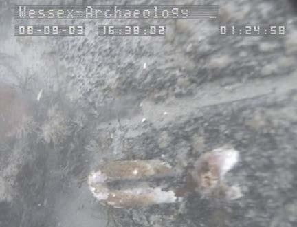
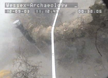
13 Click to edit Pilot Master Project title style Mary Rose PAGSA Invincible A1 Hazardous Designated wrecks 13
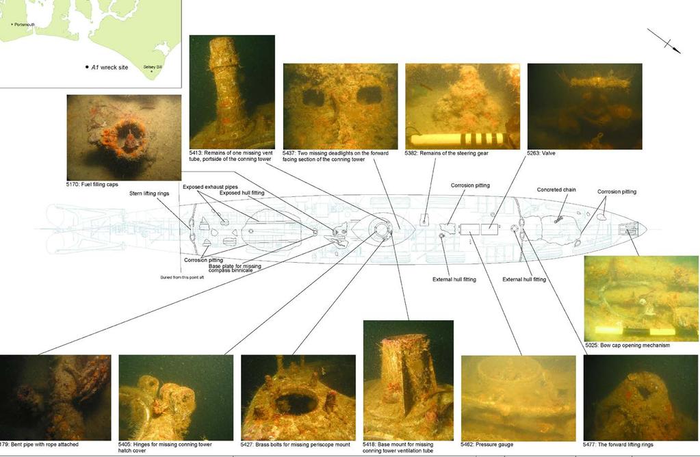
 Portsmouth Approaches SSS, MBES, SBP Portsmouth Channel SSS,")
14 Click to Pilot edit Master Project title style Portsmouth Click to edit Regeneration Master text styles Project (PRP) DBA (2003) Review of UKHO/NMR data Geophysical survey and Fourth level assessment ( ) Portsmouth Approaches SSS, MBES, SBP Portsmouth Channel SSS, magnetometer 14
15 Click to Pilot edit Master Project title style Designated Click to edit (DW) Master sites text styles Geophysical survey and assessment Second level (2003) MBES, magnetometer, SBP Mary Rose Hazardous PAGSA Invincible A1 15
 MBES, magnetometer, SBP Diver assessment A1 (2005) Invincible (2003) Mary Rose Hazardous PAGSA")
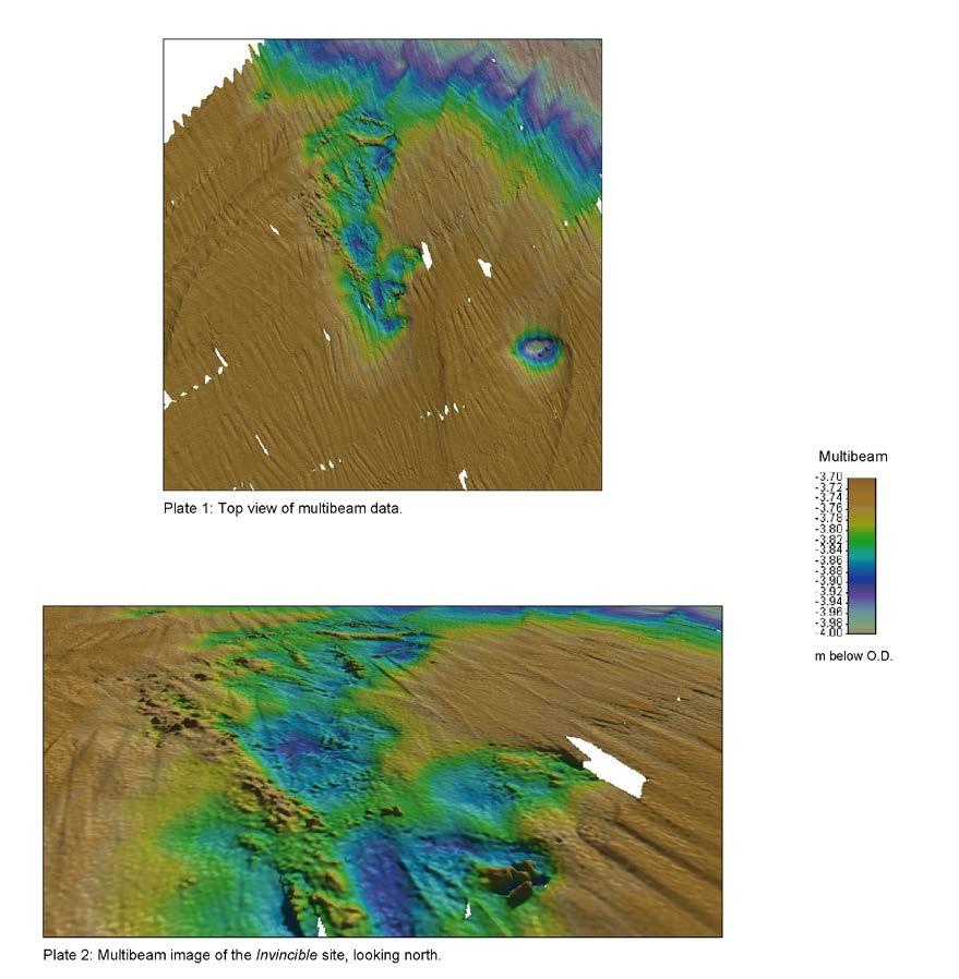
16 Click to Pilot edit Master Project title style Designated Click to edit (DW) Master sites text styles Geophysical survey and assessment Second level (2003) MBES, magnetometer, SBP Diver assessment A1 (2005) Invincible (2003) Mary Rose Hazardous PAGSA Invincible A1 16
17 Click UKHO to edit Master title style lifted wreck. Not observed UKHO dead wreck. Not observed UKHO wreck. Observed on mag data Fourth UKHO level dead wreck. Not observed UKHO 19159, and Mary Rose wreck site. Observed on sss, MBES and mag data UKHO dead wreck. Not observed UKHO Dead foul. Not observed UKHO dead wreck. Not observed NMR obstruction. Not observed Wreck Anomalies 17


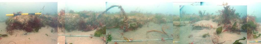
18 UKHO UKHO Second UKHO level UKHO UKHO UKHO


19 Transition Conversion Append WA Results AML Results 19


20 Example Mary Rose Designated Wreck Site 20
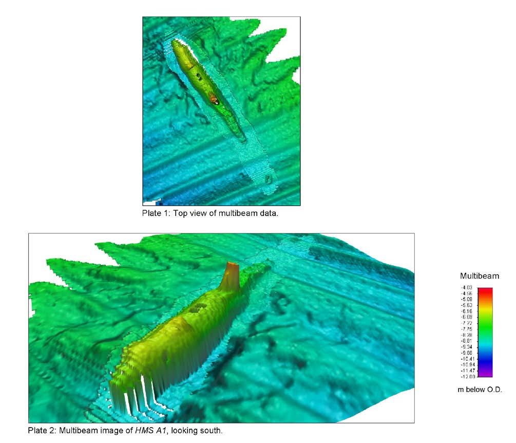
21 HMS A1 21
22 HMS A1 22
23 23

24
25 Invincible 25
26 Invincible 26
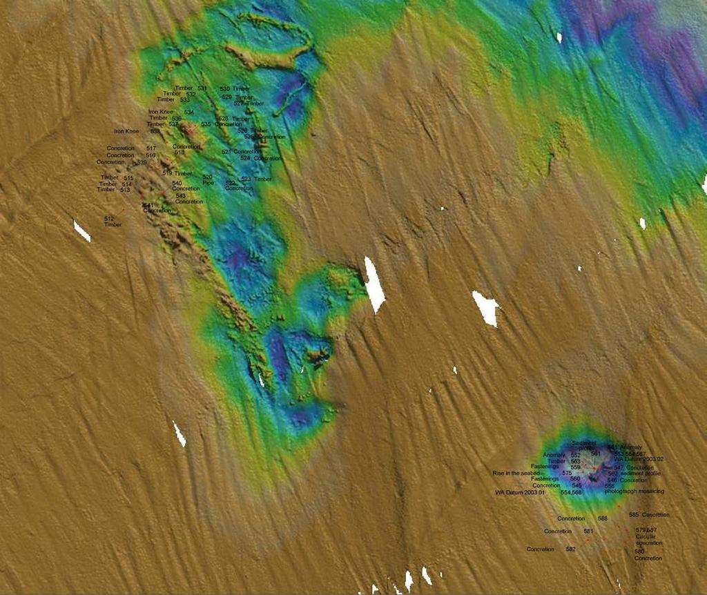
27 Diver Observations 27


28

29
30 Reporting new or enhanced wreck data All wrecks to be reported Information on form transferred from gazetteer and metadata manual or auto-transfer? Digital Images Survey report 30


31 Click UKHO to edit Master title style lifted wreck. Not observed UKHO dead wreck. Not observed UKHO wreck. Observed on mag data Fourth UKHO level dead wreck. Not observed UKHO 19159, and Mary Rose wreck site. Observed on sss, MBES and mag data UKHO dead wreck. Not observed UKHO Dead foul. Not observed UKHO dead wreck. Not observed NMR obstruction. Not observed A1 and A3 Anomalies 31
32 UKHO REPORT OF WRECK INVESTIGATION Wreck No: Method of Positioning: N/A Accuracy (2,447σ): metres Horizontal Datum: N/A Ship/Unit HMSLM Gleaner HMOI No: Survey: Wessex Archaeology: Portsmouth Regeneration Project Date located: September 2003 Date Examined/Swept: Listed Position: 50 º N 001 º W Fixed Position: º. N/S º. E/W Depth Data: Swept Clear: metres (LAT) Swept Foul: metres Least E/S Depth: metres General Depth: 1 metres Scour Depth: metres Tidal observations at: Cotidal adjustments by: Contact Data: Sonar Height: metres Sonar Length: metres Sonar Width: metres Orientation: ddd º / ddd º (Bows: ddd º ) Sonar Signal Strength: Nil Poor Moderate Strong Unknown Magnetic Anomaly: Nil Poor Moderate Strong Unknown Scour Length: metres Direction (towards): º Seabed Texture: Debris Field: Length: metres Direction (towards): º Buoyage: Description (include attitude and whether intact): UKHO lists the wreck as dead as of At the reported location no anomaly was observed on the sidescan sonar, bathymetry or magnetometer data. Approved: In Charge of Surveys Date: Sweep Diagram, E/S trace (reduced for tide), sidescan traces, magnetometer trace, investigation and close sounding plots to be included. (See HMOG Vol 1 GSI D.5.7) 32


33 REPORT OF WRECK INVESTIGATION Wreck No: Ship/Unit Emu Surveyor HMOI No: Survey: Wessex Archaeology: Wrecks on the Seabed Date located: May 2003 Date Examined/Swept: Listed Position: 50 º N 000 º W Fixed Position: 50 º N/S 000 º E/W WGS84 Method of Positioning: DGPS Accuracy (2,447σ): metres Horizontal Datum: Depth Data: Swept Clear: metres (LAT) Swept Foul: metres Least E/S Depth: 6.4 metres General Depth: 7 metres Scour Depth: metres Tidal observations at: Cotidal adjustments by: Contact Data: Sonar Height: 0.6 metres Sonar Length: metres Sonar Width: 56.8 metres Orientation: 090º / 270 º (Bows: ddd º ) Sonar Signal Strength: Nil Poor Moderate Strong Unknown Magnetic Anomaly: Nil Poor Moderate Strong Unknown Scour Length: metres Direction (towards): º Seabed Texture: Debris Field: Length: metres Direction (towards): º Buoyage: Description (include attitude and whether intact): The following description is based on multibeam and magnetic surveys of the wreck Hazardous The main wreck site shows on the multibeam data as a slight depression in the seabed orientated west to east, measuring approximately 120 x 57m and has a measurable height of 0.6m. A number of magnetic anomalies were observed on the wreck site, the largest measuring 155nT. A number of features are visible in the depression, the most prominent ones possibly representing guns. A 11m x 4m depression around 0.4m deep with a number of upstanding features is visible to the west of the main site. The prominent feature within the depression measures 2.3 x 0.7 x 0.3m, orientated west to east. A small depression, measuring 2.5m x 3.5m is situated approximately 15m north of the main site. UKHO Hazardous Plan view Approved: In Charge of Surveys Date: Sweep Diagram, E/S trace (reduced for tide), sidescan traces, magnetometer trace, investigation and close sounding plots to be included. (See HMOG Vol 1 GSI D.5.7) UKHO Hazardous View from south 33
34 Click to edit Conclusions Master title style WA Project DBA Geophysical Geophysical Acquisition and Assessment Client Fourth reports level Client digital output Reports to UKHO Processing Integration methodology Geotechnical Assessment Diving and ROV Assessments AML UKHO NMR HER OASIS COWRIE 34
35 Click to edit Conclusions Master title style WA Project DBA Geophysical Geophysical Acquisition and Assessment Client Fourth reports level Client digital output Reports to UKHO Processing Integration methodology Geotechnical Assessment Diving and ROV Assessments AML UKHO NMR HER OASIS COWRIE 35
36 Click to Conclusions edit Master title style The project has successfully integrated heritage Click data into edit AML Master products text styles Successfully proven as a MDIP/MEDIN use- Third level case Flexibility in implementation is the key Heritage data can contribute to existing databases, in particular the UKHO wreck records 36
Utilizing Vessel Based Mobile LiDAR & Bathymetry Survey Techniques for Survey of Four Southern California Breakwaters
 Utilizing Vessel Based Mobile LiDAR & Bathymetry Survey Techniques for Survey of Four Southern California Breakwaters Western Dredging Association: Pacific Chapter September 2012 Insert: Pipe Location
Acoustic Pipeline Inspection Mind The Gap
 Acoustic Pipeline Inspection Mind The Gap Mike Liddell Chief Surveyor, Fugro Survey Limited UUVS @ Oceanology 2012 13 th March 2012 Contents Menu Introduction to Pipeline Inspection The Current Toolkit
CHALLENGES IN UXO-DETECTION: COMBINING DIFFERENT GEOPHYSICAL TECHNIQUES WITHIN UXO INVESTIGATION & CLEARANCE
 PRESENTATION HYDRO 17 15/11/2017 CHALLENGES IN UXO-DETECTION: COMBINING DIFFERENT GEOPHYSICAL TECHNIQUES WITHIN UXO INVESTIGATION & CLEARANCE Jana De Cuyper - MSc Geology Conor Davidge - BSc Ocean Exploration
Scottish Hydro Electric Power Distribution Operation, Inspection, Maintenance and Decommissioning Strategy Bute Cumbrae Cable Replacement
 SHEPD Section ID 154 Scottish Hydro Electric Power Distribution Operation, Inspection, Maintenance and Decommissioning Strategy Bute Cumbrae Cable Replacement Contents Definitions and Abbreviations...
CORONATION OFFSHORE, PENLEE POINT PLYMOUTH
 ARCHAEOLOGICAL SERVICES IN RELATION TO THE PROTECTION OF WRECKS ACT (1973) CORONATION OFFSHORE, PENLEE POINT PLYMOUTH DESIGNATED SITE ASSESSMENT: FULL REPORT Prepared by: Wessex Archaeology Portway House
INVINCIBLE, SOLENT, HAMPSHIRE
 ARCHAEOLOGICAL SERVICES IN RELATION TO THE PROTECTION OF WRECKS ACT (1973) INVINCIBLE, SOLENT, HAMPSHIRE DESIGNATED SITE ASSESSMENT: FULL REPORT Prepared by: Wessex Archaeology Portway House Old Sarum
Coronation. Geophysical Survey
 Coronation Geophysical Survey Geophysical Survey report of the Coronation site Prepared for English Heritage October 2012 Title Author Derivation. Original Date Reviser Coronation Protected Wrecksite Geophysical
S-44 edition 5 The IHO s New Standard For Hydrographic Surveys Chris Howlett Head of Seabed Data Centre United Kingdom Hydrographic Office
 S-44 edition 5 The IHO s New Standard For Hydrographic Surveys Chris Howlett Head of Seabed Data Centre United Kingdom Hydrographic Office Chairman of IHO Working Group that created S-44 edition 5 S-44
Hydrographic Surveying at The Port of London
 Hydrographic Surveying at The Port of London John Dillon-Leetch Port and Terminal Technology 2009 14 th October, Antwerp Overview Introduction Surveying the Thames Navigational Charting High Resolution
An Integrated Marine Gradiometer Array System (MGA)
") An Integrated Marine Gradiometer Array System (MGA) For Detection and Location of Chemical and Conventional UXO/MEC in Shallow to Deep Marine and Freshwater Environments Introduction Tetra Tech EC, Inc.
An Integrated Marine Gradiometer Array System (MGA) For Detection and Location of Chemical and Conventional UXO/MEC in Shallow to Deep Marine and Freshwater Environments Introduction Tetra Tech EC, Inc.
Advantages of Using Combined Bathymetry and Side Scan Data in Survey Processing T.M. Hiller, L.N. Brisson
 Advantages of Using Combined Bathymetry and Side Scan Data in Survey Processing T.M. Hiller, L.N. Brisson EdgeTech, West WareHam MA, USA EdgeTech 6205 Combined Bathymetric and Side Scan Sonar EdgeTech
Multibeam and Laser: Combined High Resolution. Hydrographic Surveying for Civil Engineering Project Support
 Multibeam and Laser: Combined High Resolution Hydrographic Surveying for Civil Engineering Project Support John Dillon-Leetch,Port of London Authority Duncan Mallace, NetSurvey, UK Overview Introduction
THE CHALLENGES OF A LARGE-AREA BATHYMETRIC SURVEY
 THE CHALLENGES OF A LARGE-AREA BATHYMETRIC SURVEY Agenda: - Introduction - Tender - Project Planning - Survey - Processing - Delivery - Conclusion 2 Introduction We know less of the oceans at our feet,
Vieques Underwater Demonstration Project
 Vieques Underwater Demonstration Project NOAA Office of Response and Restoration National Ocean Service 2006-2007 2007 University of New Hampshire Joint Hydrographic Center 2006 Science Application International
UTEC Survey Pipeline Inspection Using Low Logistic AUV June 2016
 SUCCESS YOU CAN MEASURE UTEC Survey Pipeline Inspection Using Low Logistic AUV June 2016 Chris Erni Product Line Manager E T H I C S P E R F O R M A N C E E X C E L L E N C E P E O P L E GLOBAL FOOTPRINT
ICES Guidelines for Multibeam Echosounder Data (Compiled September 2006)
") ICES Guidelines for Multibeam Echosounder Data (Compiled September 2006) If you are considering producing a hydrographic survey please read the following information first. Your survey could be used to
ICES Guidelines for Multibeam Echosounder Data (Compiled September 2006) If you are considering producing a hydrographic survey please read the following information first. Your survey could be used to
Background Paper: Surveys. Nord Stream 2 AG Sep-17
 Nord Stream 2 AG Sep-17 Table of Contents Introduction... 3 Advanced Technology... 4 Survey Stages... 4 2 Introduction Survey operations are the cornerstone of massive international infrastructure projects
NOAA s Underwater UXO Demonstration Projects Vieques Island, Puerto Rico
 NOAA s Underwater UXO Demonstration Projects Vieques Island, Puerto Rico Vieques Restoration Advisory Board Meeting May 7, 2008 Jason Rolfe NOAA s Office of Response & Restoration NOAA s Underwater UXO
High Definition Laser Scanning (HDS) Underwater Acoustic Imaging and Profiling
 Underwater Acoustic Imaging and Profiling") High Definition Laser Scanning (HDS) Underwater Acoustic Imaging and Profiling Images at Depth: The Use of Acoustic Imaging on Large River Crossings A Case Study AGENDA Background of project Review of
High Definition Laser Scanning (HDS) Underwater Acoustic Imaging and Profiling Images at Depth: The Use of Acoustic Imaging on Large River Crossings A Case Study AGENDA Background of project Review of
Paper for consideration by ENC Working Group. Use of AU6 ENC cells as an option for Bathymetric ENCs (benc)
") Paper for consideration by ENC Working Group Use of AU6 ENC cells as an option for Bathymetric ENCs (benc) Submitted by: Alvaro Sanchez (AHS) Executive Summary: Compilation of high density bathymetric
Paper for consideration by ENC Working Group Use of AU6 ENC cells as an option for Bathymetric ENCs (benc) Submitted by: Alvaro Sanchez (AHS) Executive Summary: Compilation of high density bathymetric
UNDERWATER SERVICES COMPANY PROFILE
 UNDERWATER SERVICES COMPANY PROFILE irov Underwater Services is an Italian Independent H i g h l y S p e c i a l i z e d C o m p a n y p r o v i d i n g underwater technology and ROV assistance to Salvage
Certified Professionals in Hydrographic Solutions
 Certified Professionals in Hydrographic Solutions Client Satisfaction is our Deliverable Port of Brisbane Pty Ltd Port Surveys Certified Professionals in Hydrographic Surveying Tel +61 (0) 7 3258 4820
Emerging Subsea Networks
 THE FUTURE OF MARINE SURVEY APPLICATIONS FOR SUBMARINE CABLES Ryan Wopschall (Fugro) Email: rwopschall@fugro.com Fugro Pelagos, Inc. - 3574 Ruffin Road, San Diego, California 92123 USA Abstract: New advances
UK Civil Hydrography Programme Survey Specification
 UK Civil Hydrography Programme Survey Specification Civil Hydrography Services in European Waters August 2013 Part A UK Civil Hydrography Programme Survey Specification Civil Hydrography Services in European
Design and Planning Considerations For a Seabed Survey
 Design and Planning Considerations For a Seabed Survey Vera Quinlan Hydrographer & Data Processor Seabed Survey Overview Survey Platform - What boat do I use? Survey Area / depth of water / objective &
Location of Proposed Dredging Areas, spoil disposal area, beaches identified for nourishment and the Study Area Figure 1
 42 41 4 9 Little Channel Bournemouth Beach Bournemouth Beach (Sand and gravel) Middle RORO Turning Basin Ship Channel Poole Beach Swash Channel 8 Swanage Beach Admiralty Chart 2615 Study Area Proposed
INTERNATIONAL HYDROGRAPHIC REVIEW MAY 2015
 OPERATION TIRÚA: HYDROGRAPHIC VISION N.A. Guzmán Montesinos Naval Hydrographic Engineer Head of the Information Technology Department Head of the Chilean Tsunami Warning Center, Chile Abstract On 6 October
PORTS AUSTRALIA. PRINCIPLES FOR GATHERING AND PROCESSING HYDROGRAPHIC INFORMATION IN AUSTRALIAN PORTS (Version 1.5 November 2012)
") PORTS AUSTRALIA PRINCIPLES FOR GATHERING AND PROCESSING HYDROGRAPHIC INFORMATION IN AUSTRALIAN PORTS (Version 1.5 November 2012) PREFACE These Principles have been prepared by the Hydrographic Surveyors
PORTS AUSTRALIA PRINCIPLES FOR GATHERING AND PROCESSING HYDROGRAPHIC INFORMATION IN AUSTRALIAN PORTS (Version 1.5 November 2012) PREFACE These Principles have been prepared by the Hydrographic Surveyors
State of the Art Mapping of Portland Harbour - August 2004
 State of the Art Mapping of Portland Harbour - August 2004 In 2003 and 2004, as part of the "Diving with a Purpose" initiative the Nautical Archaeology Society mapped some of the wrecks in and around Portland
Advanced PMA Capabilities for MCM
 Advanced PMA Capabilities for MCM Shorten the sensor-to-shooter timeline New sensor technology deployed on off-board underwater systems provides navies with improved imagery and data for the purposes of
Geophysical and Diver Survey Report on the HEIC Halsewell for the National Trust, Purbeck Interim report
 HEIC Halsewell Wreck of the Halsewell by William Turner Geophysical and Diver Survey Report on the HEIC Halsewell for the National Trust, Purbeck Interim report Introduction 1.1.1 This document has been
2012 INDUSTRY DAY Society of American Military Engineers - Omaha Post
 2012 INDUSTRY DAY Society of American Military Engineers - Omaha Post Omaha District Corps of Engineers Military Munitions Design Center (MMDC) Glenn Marks MMDC Manager May 8, 2012 US Army Corps of Engineers
Malta Survey activities
 Malta Survey activities Malta 19 September 2016 L. Facchin OGS National Institute of Oceanography and Experimental Geophysics Offshore Multibeam (MBES) Sub bottom profiling (SBP: Chirp or Boomer) Multichannel
BASELINE SURVEY, VISUAL - SITE SPECIFIC
 BASELINE SURVEY, VISUAL - SITE SPECIFIC Introduction As stated in SEPA s policy and in the Fish Farm Manual (1998), scientific data are required by SEPA in order to assess the existing condition on the
Argentine Navy ARA San Juan (S-42) Search 2018
 Search 2018") Daily Status Report: OI Seabed Constructor 22.09.18 Key Developments; Next 24hrs; 11:32hrs LT Perform cargo transfer (2x Edge Tech Bottles etc) with ARA Admiral Brown. Acoustically maintained AUV Fleet(5)
Daily Status Report: OI Seabed Constructor 22.09.18 Key Developments; Next 24hrs; 11:32hrs LT Perform cargo transfer (2x Edge Tech Bottles etc) with ARA Admiral Brown. Acoustically maintained AUV Fleet(5)
DUALEM EM EQUIPMENT. Geostudi Astier srl Via Nicolodi, Livorno Italy
 DUALEM EM EQUIPMENT DUALEM instruments (e.g. the DUALEM-1) incorporate a DUALEM sensor as well as an internal WAAS-enabled GPS receiver, a hand-held weatherproof display/keypad/power-supply, a carrying
Geospatial Positioning Accuracy Standards Part 5: Standards for Nautical Charting Hydrographic Surveys - Public Review Draft
 Appendix B FGDC Hydrographic Accuracy Standard Geospatial Positioning Accuracy Standards Part 5: Standards for Nautical Charting Hydrographic Surveys - Public Review Draft Subcommittee on Marine and Coastal
ScanFish Katria. Intelligent wide-sweep ROTV for magnetometer surveys
 ScanFish Katria Intelligent wide-sweep ROTV for magnetometer surveys User-friendly control and monitoring software solution The ScanFish Katria comes with the ScanFish III Flight software, which is an
THE APPLICATION OF THE FUSION POSITIONING SYSTEM TO MARINE ARCHAEOLOGY
 THE APPLICATION OF THE FUSION POSITIONING SYSTEM TO MARINE ARCHAEOLOGY PETER HOLT Sonardyne International Ltd, Blackbushe Business Park, Yateley, Hants, UK E-mail: pete@threeh.demon.co.uk The Sonardyne
MISSION PLANNING AND DATA ACQUISITION SOFTWARE
 MISSION PLANNING AND DATA ACQUISITION SOFTWARE INTENTIONALLY BLANK Introduction to Divelog Shark Marine s Divelog software was created to integrate data collected from an array of sensors, real-time with
Robin J. Beaman. School of Earth and Environmental Sciences, James Cook University, Cairns, Qld 4870, Australia.
 Robin J. Beaman School of Earth and Environmental Sciences, James Cook University, Cairns, Qld 4870, Australia. Email: robin.beaman@jcu.edu.au Seminar to SSSI Qld Hydrography Coping with Nature, Brisbane,
NEED FOR SUPPLEMENTAL BATHYMETRIC SURVEY DATA COLLECTION
 305 West Grand Avenue, Suite 300 Montvale, New Jersey 07645 Phone 201.930.9890 Fax 201.930.9805 www.anchorqea.com M EMORANDUM To: Caroline Kwan and Nica Klaber U.S. Environmental Protection Agency Region
Tifft Water Supply Symposium
 Tifft Water Supply Symposium SEPTEMBER 21-22, 2016 BUFFALO, NEW YORK Impossible Journey: Underwater Inspection of Large Diameter Water Transmission Tunnel Kristin Wheaton, PE Jim Clark Bob Clarke, P.Eng,
MARINE ANTIQUITIES SCHEME
 For more information on the Marine Antiquities Scheme visit www.marinefinds.org.uk The MAS support team Wessex Archaeology Portway House Old Sarum Park Salisbury SP4 6EB T: 01722 326867 E: mas@wessexarch.co.uk
EXPEDITION ADVENTURE PART 2: HIGHER RESOLUTION RANGE SEISMIC IMAGING TO LOCATE A SUNKEN PIRATE SHIP OFF ILE ST MARIE.
 EXPEDITION ADVENTURE PART 2: HIGHER RESOLUTION RANGE SEISMIC IMAGING TO LOCATE A SUNKEN PIRATE SHIP OFF ILE ST MARIE. Jakob B.U. Haldorsen, and Douglas E. Miller, Schlumberger-Doll Research, Ridgefield,
Survey Technique for Underwater Digital Photography with Integrated GPS Location Data
 Survey Technique for Underwater Digital Photography with Integrated GPS Location Data Tim Siwiec: United States Environmental Protection Agency Abstract This survey technique is an inexpensive method of
Body Search and Recovery Using Sonar
 Body Search and Recovery Using Sonar Photos Mark W. Atherton Mark W. Atherton, Echoes and Images Image courtesy FBI Dive Team Images not for distribution. All photographs and drawings courtesy and Mark
Scanning Sonar and ROV Operations. For Underwater SAR Imaging Applications
 Scanning Sonar and ROV Operations For Underwater SAR Imaging Applications This training module provides information specific to integrating scanning sonar onto an ROV platform and fundamentals in using
With a team of highly qualified divers Vision offers a wide range of services including;
 Commercial Diving Services With a team of highly qualified divers Vision offers a wide range of services including; Civils Diving Services Inspections, Construction and maintenance on bridges, piles, quay
Data Collection and Processing: Elwha Estuary Survey, February 2013
 Data Collection and Processing: Elwha Estuary Survey, February 2013 Ian Miller, WA Sea Grant Olympic Peninsula Field Office, 1502 E. Lauridsen Blvd #82, Port Angeles, WA 98362 immiller@u.washington.edu
ENVIRONMENT AGENCY GREAT OUSE AND 100 FT DRAIN QUARTERLY BATHYMETRIC SURVEY DECEMBER 2013 SITE SURVEY REPORT NO. H6787
 ENVIRONMENT AGENCY GREAT OUSE AND 100FT DRAIN QUARTERLY BATHYMETRIC SURVEY DECEMBER 2013 NO. H6787 LONGDIN & BROWNING (SURVEYS) LIMITED CHERRY TREE HOUSE CARMARTHEN ROAD SWANSEA SA1 1HE H6787 1 Measured
FOR INFORMATION ONLY. Gold Coast Seaway Channel Scour and Rock Wall Stability Investigation. R.B doc December 2011
 A part of BMT in Energy and Environment Gold Coast Seaway Channel Scour and Rock Wall Stability Investigation R.B18625.001.00.doc December 2011 Gold Coast Seaway Channel Scour and Rock Wall Stability Investigation
Evaluation of the Klein HydroChart 3500 Interferometric Bathymetry Sonar for NOAA Sea Floor Mapping
 Evaluation of the Klein HydroChart 3500 Interferometric Bathymetry Sonar for NOAA Sea Floor Mapping Yuhui Ai, Straud Armstrong and Dean Fleury L-3 Communications Klein Associates, Inc. 11 Klein Dr. Salem,
Uncertainty Estimates in Satellite Derived Bathymetry
 Uncertainty Estimates in Satellite Derived Bathymetry Richard Flemmings, TCarta #chcnsc2018 Introduction and Overview 1. TCarta 2. Satellite Derived Bathymetry Overview 3. Satellite Derived Bathymetry
Autosub6000. Results of its Engineering Trials and First Science Missions
 Autosub6000 Results of its Engineering Trials and First Science Missions Stephen McPhail, Maaten Furlong, Veerle Huvenne, Peter Stevenson, Miles Pebody, James Perrett NOC, Southampton, UK Objectives of
FINAL REPORT DERELICT FISHING GEAR IDENTIFICATION AND REMOVAL PROJECT PORT SUSAN
 1900 W. NICKERSON, STE. 207 SEATTLE, WASHINGTON 98119-1650, U.S.A. TELEPHONE: (206) 285-3480 TELEFAX: (206) 283-8263 E-Mail : jjune@nrccorp.com (corporate) FINAL REPORT DERELICT FISHING GEAR IDENTIFICATION
Monetisation of sustainable business models for Satellite Derived Bathymetry
 Monetisation of sustainable business models for Satellite Derived Bathymetry Who are we? We are a UK & UAE based company specialising in satellite derived seabed & environmental mapping products We aim
HYDROGRAPHIC AND SITE SURVEY REPORT
 HYDROGRAPHIC AND SITE SURVEY REPORT Proposed Pen Site at Dounie, Sound of Jura Prepared for: Kames Fish Farming Ltd Kilmelford Argyll PA34 4XA Tel: +44 (0)1631 720699 TransTech Limited www.transtechltd.com
DIRECT INVENTORY TAKING OF UNDERWATER OBJECTS USING A HANDHELD GPS RECEIVER
 DIRECT INVENTORY TAKING OF UNDERWATER OBJECTS USING A HANDHELD GPS RECEIVER ABSTRACT Dariusz Popielarczyk Chair of Satellite Geodesy and Navigation Warmia and Mazury University in Olsztyn The paper presents
Trial of a process to estimate depth of cover on buried pipelines
 Trial of a process to estimate depth of cover on buried pipelines Daniel Finley (CEng MIMechE) Principal Engineer ROSEN Group Third Party Interference Protection against 3rd party interference can be an
GNSS Technology for the Determination of Real-Time Tidal Information
 GNSS Technology for the Determination of Real-Time Tidal Information Benjamin Kidder C-Nav Positioning Solutions European region Outline of Topics Covered Introduction to Tides Past and Present Methods
from ocean to cloud PARAMETRIC SUB-BOTTOM PROFILER, A NEW APPROACH FOR AN OLD PROBLEM
 PARAMETRIC SUB-BOTTOM PROFILER, A NEW APPROACH FOR AN OLD PROBLEM Geoff Holland, Alcatel-Lucent Submarine Networks Geoff.holland@alcatel-lucent.com Alcatel-Lucent Submarine Networks Ltd, Christchurch Way,
UNEXPLODED ORDNANCE (SEPARATING FACT FROM FICTION)
") UNEXPLODED ORDNANCE (SEPARATING FACT FROM FICTION) Mike Sainsbury, Managing Director 21 June 2017 1 ZETICA WHO ARE WE? Who are Zetica Mapping hazards UXO Risk assessment/desk studies Detection Investigation
UNEXPLODED ORDNANCE (SEPARATING FACT FROM FICTION) Mike Sainsbury, Managing Director 21 June 2017 1 ZETICA WHO ARE WE? Who are Zetica Mapping hazards UXO Risk assessment/desk studies Detection Investigation
Stourport motor barge Severn Collier
 The Purton Hulks Phase 1 Report No 21 Stourport motor barge Severn Collier The Friends of Purton Compiled 1 st March 2010 - 2 - Contents 1.1 Vessel identification page 5 1.2 Photographic comparison page
AHO s experience on HD bathymetric ENCs
 AHO s experience on HD bathymetric ENCs ENCWG3 Wollongong 16 18 April 2018 Alvaro Sanchez DD Charting Quality Assurance, Standards and Specifications Australian Hydrographic Office Background 2016 As part
ROV Development ROV Function. ROV Crew Navigation IRATECH SUB SYSTEMS 2010
 IR AT EC H SU B SY ST EM S 20 10 Remotely Operated Vehicle ROV INTRODUCTORY 2008 2008 1 KEY POINTS ROV Introductory ROV Development ROV Function Types of ROV ROV Crew Navigation ROV Components 2 ROV Development
Perth Schooner Sarah MacDonad
 The Purton Hulks Phase 1 Report No 33 Perth Schooner Sarah MacDonad The Friends of Purton Compiled 1 st March 2010 - 2 - Contents 1.1 Vessel identification page 5 1.2 Photographic comparison page 6 1.2.1
Wrecking barge Petrus
 The Purton Hulks Phase 1 Report No 14 Wrecking barge Petrus The Friends of Purton Compiled 1 st March 2010 - 2 - Contents 1.1 Vessel identification page 5 1.2 Photographic comparison page 6 1.2.1 Historic
The optimal position of a sidescan sonar towfish fixed to a shellfish vessel for very shallow surveys an experiment in the Dutch Wadden Sea
 Title: Author(s): Document owner: The optimal position of a sidescan sonar towfish fixed to a shellfish vessel for very shallow surveys an experiment in the Dutch Wadden Sea Ronnie van Overmeeren (TNO)
International Journal of Naval History
 A Global Forum for Naval Historical Scholarship International Journal of Naval History December 2010 Volume 8 Number 3 Searching for Bonhomme Richard, Flagship of John Paul Jones Alexis Catsambis Melissa
The Mystery Wreck, (Aggregate Area 122/2 - UMD), Eastern Solent: Desk Based Assessment
, Eastern Solent: Desk Based Assessment") The Mystery Wreck, Eastern Solent: Desk Based Assessment (Stage ) The Mystery Wreck, (Aggregate Area 22/2 - UMD), Eastern Solent: Desk Based Assessment Stage Final Report Prepared by Hampshire & Wight
The Mystery Wreck, Eastern Solent: Desk Based Assessment (Stage ) The Mystery Wreck, (Aggregate Area 22/2 - UMD), Eastern Solent: Desk Based Assessment Stage Final Report Prepared by Hampshire & Wight
IFREMER, Department of Underwater Systems, Toulon, France. L u c i e Somaglino, P a t r i c k J a u s s a u d, R o main P i a s co, E w e n Raugel
 F i r s t s e a t r i a l s w i t h E M 2 0 4 0 m u l t i b e a m s o u n d e r i n n o v a t i v e i n t e g r a t i o n o n H y b r i d R O V A r i a n e IFREMER, Department of Underwater Systems, Toulon,
1 st Tidal and Water Level Working Group Meeting DHN, Niteroi, Brazil 31/03/09 02/04/09 Vertical Offshore Reference Framework (VORF) Chris Jones
 Chris Jones") 1 st Tidal and Water Level Working Group Meeting DHN, Niteroi, Brazil 31/03/09 02/04/09 Vertical Offshore Reference Framework (VORF) Chris Jones United Kingdom Hydrographic Office Presentation Structure
1 st Tidal and Water Level Working Group Meeting DHN, Niteroi, Brazil 31/03/09 02/04/09 Vertical Offshore Reference Framework (VORF) Chris Jones United Kingdom Hydrographic Office Presentation Structure
Isles of Scilly. Project Report. Designated Wrecks Interpretation. Tom Goskar & Mark James. W i t h c o n t r i b u t i o n s b y
 Isles of Scilly Designated Wrecks Interpretation Project Report Kevin Camidge W i t h c o n t r i b u t i o n s b y Tom Goskar & Mark James Project Name Isles of Scilly Designated Wrecks Interpretation
FIG: 27.1 Tool String
 Bring up Radioactive Tracer service. Click Acquisition Box - Edit - Tool String Edit the tool string as necessary to reflect the tool string being run. This is important to insure proper offsets, filters,
Wessex Archaeology. Iona II, Off Lundy Island, North Devon. Designated Site Assessment: Archaeological Report
 Wessex Archaeology Iona II, Off Lundy Island, North Devon Designated Site Assessment: Archaeological Report Ref: 53111.03mmm January 2009 ARCHAEOLOGICAL SERVICES IN RELATION TO THE PROTECTION OF WRECKS
SeaSmart. Jonathan Evans
 SeaSmart A new approach for rapid, on-site resource assessment at potential tidal stream energy array sites using MAS Marine Solutions for the Deep Data World Jonathan Evans Presentation Outline Marine
Marine Renewables Industry Association. Marine Renewables Industry: Requirements for Oceanographic Measurements, Data Processing and Modelling
 Marine Renewables Industry Association Marine Renewables Industry: Requirements for Oceanographic Measurements, Data Processing and Modelling October 2009 Table of Contents 1. Introduction... 1 2. Measurements
Geophysical Investigations of the Cattewater Wreck
 Reference: PLYCAT_07GEO August 2010 Geophysical Investigations of the Prepared by: Peter Holt 3H Consulting Ltd. 6 Honcray, Plymouth, PL9 7RP UK pete@3hconsulting.com Copyright 3H Consulting Ltd 2010 Cover
Between East and West The Phoenician Shipwreck off Gozo
 Between East and West The Phoenician Shipwreck off Gozo Season Report Dr Timmy Gambin Department of Classics & Archaeology University of Malta October 2017 Preamble Research on the Phoenician shipwreck
Potential applications of AUVs and Gliders in Offshore Windfarm Site Surveys
 Potential applications of AUVs and Gliders in Offshore Windfarm Site Surveys Dr James Hunt (National Oceanography Centre, Southampton) MREKE Internship in partnership with MARS at NOCS Introduction to
INTERNATIONAL HYDROGRAPHIC ORGANIZATION
 INTERNATIONAL HYDROGRAPHIC ORGANIZATION S-67 MARINERS GUIDE TO ACCURACY OF ELECTRONIC NAVIGATIONAL CHARTS (ENC) Edition 0.5 July 2017 Copyright International Hydrographic Organization 2017 This work is
14/10/2013' Bathymetric Survey. egm502 seafloor mapping
 egm502 seafloor mapping lecture 10 single-beam echo-sounders Bathymetric Survey Bathymetry is the measurement of water depths - bathymetry is the underwater equivalent of terrestrial topography. A transect
Sentry de-brief summaries 2011/2012
 Three cruises*: 1 Sentry/TowCam 1 Sentry/TowMag 1 Sentry/Jason *All cruises were post-refit 1 Pre-Cruise Planning: For two cruises everything was fine and went well For 1 cruise - planning began just one
Welcome! Did You Know...? Aquatic Centre Dock Rebuild. Key Objectives
 1 Welcome! Aquatic Centre Dock Rebuild The City of Vancouver is improving the dock at the Vancouver Aquatic Centre, which is nearing the end of its service life and is in need of replacement. This creates
The Evolution of an Autonomous Unmanned Surface Vessel and Software for Hydrographic Survey
 The Evolution of an Autonomous Unmanned Surface Vessel and Software for Hydrographic Survey Paul Donaldson In 2017, Leidos, Inc. participated in both the Gulf of Mexico Unmanned Systems Operational Demonstration
High Frequency Acoustical Propagation and Scattering in Coastal Waters
 High Frequency Acoustical Propagation and Scattering in Coastal Waters David M. Farmer Graduate School of Oceanography (educational) University of Rhode Island Narragansett, RI 02882 phone: (401) 874-6222
Panel Discussion on unmanned Hydrography
 Panel Discussion on unmanned Hydrography Overview Why bother General Types Autonomous Underwater Vehicle (AUV) Remotely Operated Vehicle (ROV) Unmanned Surface Vessels (USV) TerraSond s Experiences AUV
High Precision Hydrography in Canada, the ST. Lawrence River Channel, HD Bathymetry, Production, Distribution and Updating
 High Precision Hydrography in Canada, the ST. Lawrence River Channel, HD Bathymetry, Production, Distribution and Updating Marc Journault Canada CHS, Louis Maltais Canada CHS, and Richard Sanfaçon Canada
MAHS Field School 2018 Pickles Reef Florida Keys National Marine Sanctuary
 MAHS Field School 2018 Pickles Reef Florida Keys National Marine Sanctuary MAHS returned to Pickles Reef in June of 2018 to hold its annual field school. Pickles Reef lies about 6 miles from Key Largo
Angela Lane, Lowe Environmental Impact / Karen Akuhata (WDC) The Wairoa wastewater treatment system requires a replacement consent by May 2019.
 The Wairoa wastewater treatment system requires a replacement consent by May 2019.") MEMORANDUM Job No.10292 To: From: Jamie Cox, Wairoa District Council Angela Lane, Lowe Environmental Impact / Karen Akuhata (WDC) Date: 11 September 2017 Subject: Task A2I2 Current Outfall Pipe Description
MEMORANDUM Job No.10292 To: From: Jamie Cox, Wairoa District Council Angela Lane, Lowe Environmental Impact / Karen Akuhata (WDC) Date: 11 September 2017 Subject: Task A2I2 Current Outfall Pipe Description
Saab Seaeye Cougar XT Compact
 The Seaeye Cougar-XT Compact is a highly flexible and extremely powerful electric ROV with working depths of 300 metres. This system comes with almost all of the specifications of the very reliable Couger-XT
INTERNATIONAL HYDROGRAPHIC SURVEY STANDARDS
 INTERNATIONAL HYDROGRAPHIC SURVEY STANDARDS by Gerald B. MILLS 1 I. Background The International Hydrographic Organization (IHO) traces its origin to the establishment of the International Hydrographic
COXSWAIN NAVIGATION EXERCISES AUS197 NAME:
 COXSWAIN NAVIGATION EXERCISES AUS197 NAME: A deviation card is supplied at the end of this file. Check the answers Question 1 Using any chart (or use the AUS 197 extract) to: 1. Identify a distance of
A PRACTICAL APPROACH TO QUALITY CONTROL AND QUALITY ANALYSIS OF DEPTH DATA
 A PRACTICAL APPROACH TO QUALITY CONTROL AND QUALITY ANALYSIS OF DEPTH DATA ABSTRACT Ulf Olsson, Mats Ericson, Stigbjörn Nilsson, Hans Öiås Hydrographic Office, Swedish Maritime Administration, Sweden Quality
Chapter 2 Civil Works Applications
 Chapter 2 Civil Works Applications 2-1. General Scope Hydrographic surveys are performed to support the Corps' dredging, navigation, and flood control missions. A wide range of hydrographic survey techniques,
RAMSTM. 360 Riser and Anchor-Chain Integrity Monitoring for FPSOs
 RAMS 360 Riser and Anchor-Chain Integrity Monitoring for FPSOs Introduction to RAMS Tritech s RAMS is a 360 anchor-chain and riser integrity monitoring system for Floating Production Storage and Offloading
Investigating Acoustic Anomalies in the Water Column. Alistair Robertshaw, Geohazards Specialist, BP Oceanology 2016
 Investigating Acoustic Anomalies in the Water Column Alistair Robertshaw, Geohazards Specialist, BP Oceanology 2016 Overview Water Column Data First Impressions Basic Theory Reflection Geometries Examples
A Remote-sensing Survey of Key West Harbor and Approaches,
 A Remote-sensing Survey of Key West Harbor and Approaches, 2003-2004 Magnetometers Ready to be Deployed, Key West Harbor, December, 2003 Prepared by: Corey Malcom Mel Fisher Maritime Heritage Society 200
S.S. MONTEBELLO Assessment Radiation Detection Case Study
 S.S. MONTEBELLO Assessment Radiation Detection Case Study Specifications Owner: Union Company of California Launched: San Pedro, CA - January 1921 Tonnage: 6010 (Underdeck) Dimensions: 440 ft (Registered)