Hydrographic Surveying:
|
|
|
- Rosanna Burns
- 5 years ago
- Views:
Transcription
1 Hydrographic Surveying: Specifications & Standards IHO USACE NOAA Captain Bob Pawlowski, NOAA (Ret), MNI
2 History of Hydrography 13 th century first known chart Does not include Asia China and Japan 15 th century portolans for sailing Mediterranean to England 16 th century sailing by caping the ship & Dutch Mirrors of the Sea 17 th century Mapping of the British Coast First school of Hydrography in Dieppe France First National Hydrographic Office 18 th century Invention of station pointer (three armed protractor) 19 th century Survey of the Coast for the United States 20 th Century Century of Technology Acoustics, Radio navigation, computers, precise positioning
3 Charting Technology Leadline and Visual shore signals Wire Drag survey First fathometers and Radio Acoustic Ranging Automatic Recording Fathometer Shoran (Radar positioning system) Long and Medium range Hyperbolic positioning systems Digital data collection 1970s - Narrow Beam Fathometer & Side scan sonar 1980s - Dual Beam Fathometer Multi-Beam Sounding System 1990s - Global Positioning System Shallow Water Multi-Beam System Digital Terrain Modeling (quality control & visualization) Integrated sensor technology


4 Sea Floor Coverage by Survey Instrument Single Beam Sidescan Multibeam Continuous Line of Depth Points Continuous swath of detailed imagery Continuous Array of Depth Points and Imagery
5 Standards of Performance IHO M-13 USACE Hydrographic Surveying Engineering Manual NOAA Specifications and Deliverables Survey Standards Horizontal Control NGS & GPS Vertical Control Co-Ops Manuals Professional Papers & Associations Hydro Magazine & Hydro Conference IHO & THSOA
6 IHO M-13 Table of Contents CHAPTER 1: PRINCIPLES OF HYDROGRAPHIC SURVEYING CHAPTER 2: POSITIONING CHAPTER 3: DEPTH DETERMINATION CHAPTER 4: SEAFLOOR CLASSIFICATION AND FEATURE DETECTION CHAPTER 5: WATER LEVELS AND FLOW CHAPTER 6: TOPOGRAPHIC SURVEYING CHAPTER 7: HYDROGRAPHIC PRACTICE
7 Orders of Surveys IHO Orders Special Order scale First Order accuracy Second Order Third Order Minimum standards in Table 1.1
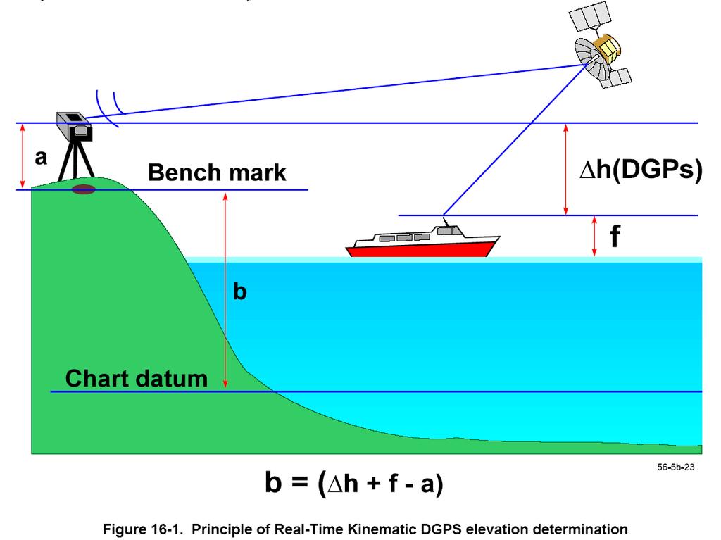
8 Horizontal Accuracy - Radius IHO Standards : Special Order - First Order - Second Order - Third Order - 2 meters 5 meters + 5% of depth 20 meters + 5% of depth 150 meters + 5% of depth DGPS is First Order Survey Accuracy
9 Sounding standards equation Vertical Accuracy Relative to depth ± 2 [ a + ( b* d ) 2 Special Order: a=0.25, b=.0075 and d=depth 1 st Order: a = 0.5, b = and d = depth. 2 nd & 3 rd Order : a=1.0, b =0.023 and d=depth
10 Bottom Coverage Special Order 100% compulsory cubic resolution >1 m First Order 100% in selected areas (navigation channels) cubic resolution >2 m to 40 m, 10% depth beyond 40 m line spacing 3 x water depth or 25 m, whichever is greater Second Order 100% may be required in selected areas cubic resolution >2 m to 40 m, 10% depth beyond 40 m line spacing 3-4 x water depth or 200 m, whichever is greater Third Order Not applicable for coverage or cubic resolution Line spacing 4 x average water depth
11 Zone of Confidence A1: Modern Survey +/- 5 m &.05m +1% d : full survey achieved A2: Complete Survey +/-20m & 1.0m + 2% d : full survey achieved B: Incomplete Survey +/-50m & 1.0m + 2% d : systematic C: Incomplete survey +/-500m & 2.0m + 5% d : low accuracy survey D: Worse than C Poor data or information can not be assessed U: Unassessed Table 1.2. Categories of Zone of Confidence in Data ZOC Table
12
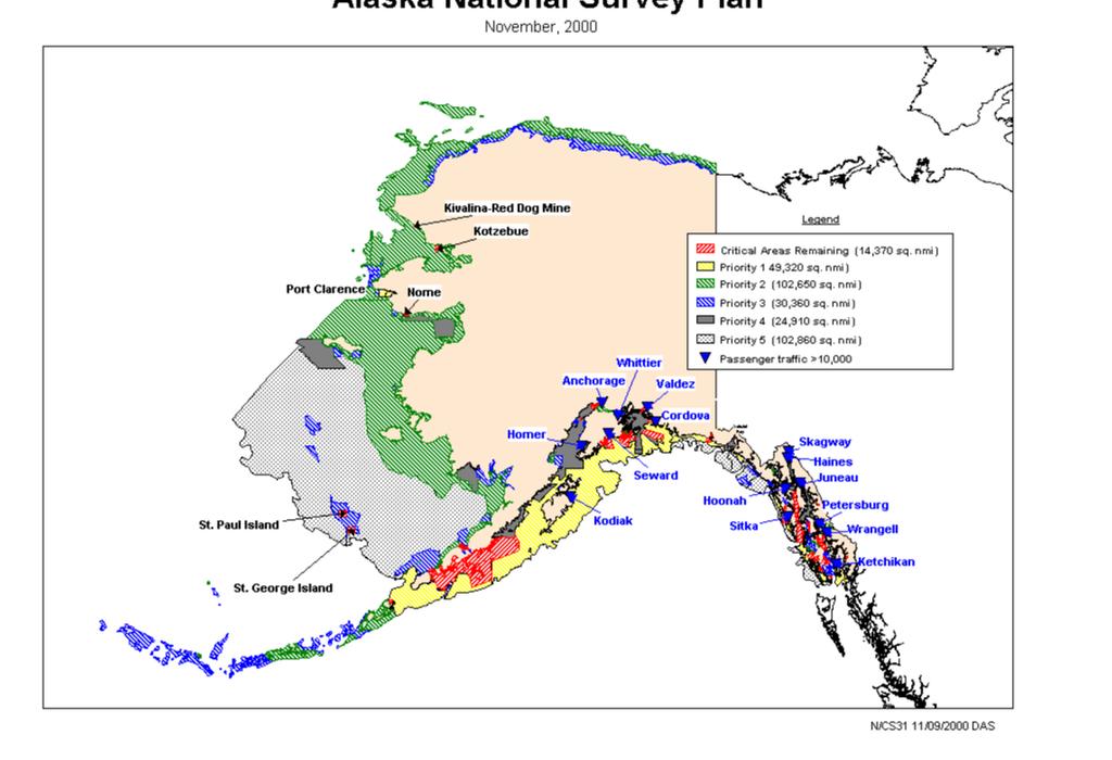
13 Perspective of survey data in Alaska 60% of nations critical survey needs in Alaska Huge area marginally surveyed Change with geologic activity Earthquakes Volcanoes Glaciers Coastal Erosion and Deposition Changing coastal commerce Fishing Mineral Exploration, Development and Shipping Oil & Gas Development and Maintenance Tourism Critical Habitat designation
14 Sonar Equation Echo detection depends on the factors of the Sonar Equation: EE = SL 2TL-(NL-DI)+BS-DT EE is Echo Excess SL is Source Level TL is Transmission Loss (2x for down and back) NL is Noise Level DI is Directivity Index BS is Back Scatter DT is Detection Threshold
15 Sound Velocity & Depth Sound Velocity Sounding to and from Determined by temperature and salinity Impacted by thermoclines and pycnoclines Formula: D = V * T + K + D r 2 Where V = sound velocity; T=time, K=system constant, & D r = transducer depth Example Sampling depths of instruments on 1000 m
![Sound Velocity C (Z, T, S) = 1449.05 + T[4.57 - T(0.0521-0.00023 T)] + (3. 17) + [1.333 - T(0.0126-0.00009 T)](S - 35) + Δ(Z) 16.](/docs-images/89/99634427/images/16-0.jpg "3 Z + 0.18 Z 2 C = sound speed (m/s) T = temperature ( o c) S = salinity (psu) Z = depth (m) As presented by Coppens [Kinsler et al.")
16 Sound Velocity C (Z, T, S) = T[ T( T)] + (3. 17) + [ T( T)](S - 35) + Δ(Z) 16.3 Z Z 2 C = sound speed (m/s) T = temperature ( o c) S = salinity (psu) Z = depth (m) As presented by Coppens [Kinsler et al., 1982]:
17 Ellipsoid The three-dimensional shape obtained by rotating an ellipse about its minor axis The major and minor axes are not the same Many people use the terms Spheroid and Ellipsoid interchangeably.

18 The Geoid Earth-Shaped, gravity based Results from Flattening at the poles and bulging a the equator Bulges and depressions irregularly located around the Earth Critical for large-scale mapping and is the reference surface for groundsurveyed horizontal and vertical positions Models of the geoid referenced to an ellipsoid

19 Alaska Geoid Geoid-forming data are gravity based using gravimeters Improved on by vertical bench mark leveling Neither dataset is adequately populated in Alaska Causes gaps in the modeling NGS Geoid99 is the most recent for the state Has errors of up to 2 meters Geoid99 Alaska
 Repeatable Separation is not constant NOS/NGS 58 Standards Ref to WGS-84 GEOID99, GEOID2004 Documentation of")
20 Ellipsoid Heights and Tide Datums Ellipsoid Heights now being required on Tidal Benchmarks Relationship of Ellipsoid Heights to Tide Datums EH more stable Used for Aircraft positioning (LIDAR, photogrammetry) Repeatable Separation is not constant NOS/NGS 58 Standards Ref to WGS-84 GEOID99, GEOID2004 Documentation of Results
21


22 NOAA NWLON Gauges in Alaska
23 Shoreline change with tectonic activities along the Aleutian and Kodiak Islands ( with specific stations
 occur every other weak neap tides (low ranges) occur between spring")
24 Time Scales Longer cycles of variation also appear in measured tides spring tides (high range) occur every other weak neap tides (low ranges) occur between spring tides

25 Tidal Constituents Complex tidal variations can be modeled by adding the effects of separate waves these separate amplitudes and frequencies define tidal constituents

26 Cotidal Lines, Gulf of Alaska Cotidal lines in Cook Inlet, Alaska give the impression of a wave washing up the inlet Time differences are predictable by the phase speed equation c = gh

27 Corange Lines, Gulf of Alaska In Cook Inlet, ranges on the east side are higher than points directly across, on the west side (along cotidal lines)


28 STATION HIERARCHY TERTIARY PRIMARY TIDE STATION: more minimum than 30 of days 19 but years less than a year SECONDARY allows statistical TIDE and STATION: datum control for short term stations minimum of 1 yr but less than 19 yrs

29 Tide Measurements Long-term statistical analysis of measured water levels results in these statistical levels A tidal epoch of 19- years is required to measure all astronomical variations
30 ELEVATIONS ON STATION DATUM National Ocean Service (NOAA) Station: T.M.: 0 W Name: SELDOVIA, COOK INLET, AK Units: Meters Status: Accepted Epoch: Datum Value Description MHHW Mean Higher-High Water MHW Mean High Water DTL Mean Diurnal Tide Level MTL Mean Tide Level MSL Mean Sea Level MLW Mean Low Water MLLW Mean Lower-Low Water SELDOVIA, COOK INLET (Tide Staff) TIDAL EPOCH: CONTROL TIDE STATION: Elevations of datums referred to MLLW (Mean Lower Low Water) METERS: MHHW = MHW = MSL = MTL = MLW = MLLW = GT Great Diurnal Range MN Mean Range of Tide DHQ Mean Diurnal High Water Inequality DLQ Mean Diurnal Low Water Inequality HWI Greenwich High Water Interval (in Hours) LWI 4.92 Greenwich Low Water Interval (in Hours) NAVD North American Vertical Datum

31 Tide Stations w/ Published Datums NTDE stations NTDE stations

32 Unpublished Tide Stations Lower Cook Inlet
33 Figure Corange Line of Greenwich, High and Low Water Intervals (In Hours)
34 Figure Tidal Zoning for Approaches to Nikiski, Alaska
35 Figure Final Tide Note and Final Tidal Zoning Chart (continued)
36 Topographic Surveying & Shoreline Determination RTK-GPS Horizontal and vertical accuracy Photogrammetry Tide Coordinated Limited in Alaska Satellite Altimetry Inadequate resolution in Western and Northern Alaska

37 USACE Coastal Engineering Surveys
38
39
40 Hydrographic Practice Project Planning Site Characterization Data Assessment Resource Allocation Platform and Technology Data Acquisition Horizontal and Vertical Control Depth determination Accuracy and Quality Control Data Products and Reports As defined by standards
41 ACSM CERTIFICATION Officially recognized by ACSM Does not supersede State Registration/Certification 5 years hydrographic experience 2 years in technical charge 2 years in the field Application & Examination 1000 word essay 2 part examination Internet Information
INTERNATIONAL HYDROGRAPHIC SURVEY STANDARDS
 INTERNATIONAL HYDROGRAPHIC SURVEY STANDARDS by Gerald B. MILLS 1 I. Background The International Hydrographic Organization (IHO) traces its origin to the establishment of the International Hydrographic
Geospatial Positioning Accuracy Standards Part 5: Standards for Nautical Charting Hydrographic Surveys - Public Review Draft
 Appendix B FGDC Hydrographic Accuracy Standard Geospatial Positioning Accuracy Standards Part 5: Standards for Nautical Charting Hydrographic Surveys - Public Review Draft Subcommittee on Marine and Coastal
David Wolcott Lijuan Huang Stephen Gill. Center for Operational Oceanographic Products and Services National Ocean Service/ NOAA Silver Spring, MD
 Establishing Tide Control in an Area with Insufficient Observational Water Level Data: A Case Study of the Kuskokwim River, AK David Wolcott Lijuan Huang Stephen Gill Center for Operational Oceanographic
E4014 Construction Surveying. Hydrographic Surveys
 E4014 Construction Surveying Hydrographic Surveys Charts And Maps Hydrographic Chart an information medium and a tool for maritime traffic for the safety and ease of navigation contains information on
Tides. Tides: longest waves. or seas. or ripples
 Tides or ripples or seas Tides: longest waves Tides Definition: The rise and fall of sea level due to the gravitational forces of the Moon and Sun and the rotation of the Earth. Why tides are important?
Theory and Application Introductory Oceanography Ray Rector: Instructor
 OCEAN TIDES Theory and Application Introductory Oceanography Ray Rector: Instructor Tidal Concepts Tides are extremely swift, very long-wavelength, shallow-water waves Tides are periodic short-term changes
TIDES. Theory and Application
 TIDES Theory and Application Tidal Concepts Tides are extremely swift, very long-wavelength, shallow-water waves Tides are periodic short-term changes in sea level at a particular place caused by the gravitational
GNSS Technology for the Determination of Real-Time Tidal Information
 GNSS Technology for the Determination of Real-Time Tidal Information Benjamin Kidder C-Nav Positioning Solutions European region Outline of Topics Covered Introduction to Tides Past and Present Methods
Utilizing Vessel Based Mobile LiDAR & Bathymetry Survey Techniques for Survey of Four Southern California Breakwaters
 Utilizing Vessel Based Mobile LiDAR & Bathymetry Survey Techniques for Survey of Four Southern California Breakwaters Western Dredging Association: Pacific Chapter September 2012 Insert: Pipe Location
Advantages of Using Combined Bathymetry and Side Scan Data in Survey Processing T.M. Hiller, L.N. Brisson
 Advantages of Using Combined Bathymetry and Side Scan Data in Survey Processing T.M. Hiller, L.N. Brisson EdgeTech, West WareHam MA, USA EdgeTech 6205 Combined Bathymetric and Side Scan Sonar EdgeTech
Chapter 11 Tides. A tidal bore is formed when a tide arrives to an enclosed river mouth. This is a forced wave that breaks.
 Chapter 11 Tides A tidal bore is formed when a tide arrives to an enclosed river mouth. This is a forced wave that breaks. Tidal range can be very large Tide - rhythmic oscillation of the ocean surface
Evaluation of the Klein HydroChart 3500 Interferometric Bathymetry Sonar for NOAA Sea Floor Mapping
 Evaluation of the Klein HydroChart 3500 Interferometric Bathymetry Sonar for NOAA Sea Floor Mapping Yuhui Ai, Straud Armstrong and Dean Fleury L-3 Communications Klein Associates, Inc. 11 Klein Dr. Salem,
1 st Tidal and Water Level Working Group Meeting DHN, Niteroi, Brazil 31/03/09 02/04/09 Vertical Offshore Reference Framework (VORF) Chris Jones
 Chris Jones") 1 st Tidal and Water Level Working Group Meeting DHN, Niteroi, Brazil 31/03/09 02/04/09 Vertical Offshore Reference Framework (VORF) Chris Jones United Kingdom Hydrographic Office Presentation Structure
1 st Tidal and Water Level Working Group Meeting DHN, Niteroi, Brazil 31/03/09 02/04/09 Vertical Offshore Reference Framework (VORF) Chris Jones United Kingdom Hydrographic Office Presentation Structure
14/10/2013' Bathymetric Survey. egm502 seafloor mapping
 egm502 seafloor mapping lecture 10 single-beam echo-sounders Bathymetric Survey Bathymetry is the measurement of water depths - bathymetry is the underwater equivalent of terrestrial topography. A transect
Real Time Surveying GPS and HYDRO Software for Tide and Swell Compensation
 Real Time Surveying GPS and HYDRO Software for Tide and Swell Compensation by Mr Michael Walker, B.Surv. (Otago) HYDRO Division Trimble Navigation New Zealand Ltd. Abstract This paper focuses on the use
AD-SDI DATA CONTENT STANDARD
 AD-SDI DATA CONTENT STANDARD COASTLINE DATA Version 1.0 August 2010 Prepared by Abu Dhabi Systems and Information Centre (ADSIC) Abu Dhabi, UAE REVISION HISTORY Revision # Reason Effective Date 1 Original
THE CHALLENGES OF A LARGE-AREA BATHYMETRIC SURVEY
 THE CHALLENGES OF A LARGE-AREA BATHYMETRIC SURVEY Agenda: - Introduction - Tender - Project Planning - Survey - Processing - Delivery - Conclusion 2 Introduction We know less of the oceans at our feet,
Bathymetry Data Collection for Subaqueous Soil Mapping. Maggie Payne 2 nd National Workshop on Subaqueous Soils Rhode Island August 9-12, 2010
 Bathymetry Data Collection for Subaqueous Soil Mapping Maggie Payne 2 nd National Workshop on Subaqueous Soils Rhode Island August 9-12, 2010 Overview of Method Collect tide data Collect bathymetry data
Data Collection and Processing: Elwha Estuary Survey, February 2013
 Data Collection and Processing: Elwha Estuary Survey, February 2013 Ian Miller, WA Sea Grant Olympic Peninsula Field Office, 1502 E. Lauridsen Blvd #82, Port Angeles, WA 98362 immiller@u.washington.edu
Introduction. VORF - Model Development and Principles. The required VORF model transformation accuracies were as follows:
 Introduction In 2006, the United Kingdom Hydrographic Office (UKHO) began testing of the Vertical Offshore Reference Frame (VORF), which had been developed on their behalf by the Department of Geomatic
SURFACE CURRENTS AND TIDES
 NAME SURFACE CURRENTS AND TIDES I. Origin of surface currents Surface currents arise due to the interaction of the prevailing wis a the ocean surface. Hence the surface wi pattern (Figure 1) plays a key
Boothbay Harbor Rotary Club May 12, 2016
 Mapping Potential Sea Level Rise and Storm Surge in Boothbay Harbor, ME Boothbay Harbor Rotary Club May 12, 2016 Peter A. Slovinsky, Marine Geologist Maine Geological Survey S.M. Dickson, MGS Quickly,
Figure 4, Photo mosaic taken on February 14 about an hour before sunset near low tide.
 The Impact on Great South Bay of the Breach at Old Inlet Charles N. Flagg and Roger Flood School of Marine and Atmospheric Sciences, Stony Brook University Since the last report was issued on January 31
NEED FOR SUPPLEMENTAL BATHYMETRIC SURVEY DATA COLLECTION
 305 West Grand Avenue, Suite 300 Montvale, New Jersey 07645 Phone 201.930.9890 Fax 201.930.9805 www.anchorqea.com M EMORANDUM To: Caroline Kwan and Nica Klaber U.S. Environmental Protection Agency Region
Challenges in determining water surface in airborne LiDAR topobathymetry. Amar Nayegandhi, Dewberry 15 th Annual JALBTCX Workshop, June 11 th 2014
 Challenges in determining water surface in airborne LiDAR topobathymetry Amar Nayegandhi, Dewberry 15 th Annual JALBTCX Workshop, June 11 th 2014 Why topobathy LiDAR? Complements acoustic (multi-beam sonar)
Chart Specifications of the IHO Publication S-4 (Formerly M-4)
") TWLWG3/4/11A Publication S-4 (Formerly M-4) Attached to this document is an extract from IHO Publication S-4 which relate to Tidal and Water Level Information. The TWLWG is requested to review this information
TWLWG3/4/11A Publication S-4 (Formerly M-4) Attached to this document is an extract from IHO Publication S-4 which relate to Tidal and Water Level Information. The TWLWG is requested to review this information
Determination of Survey Boat Heave Motion with the Use of RTS Technique
 Environmental Engineering 10th International Conference Vilnius Gediminas Technical University Lithuania, 27 28 April 2017 http://enviro.vgtu.lt eissn 2029-7092 / eisbn 978-609-476-044-0 Article ID: enviro.2017.229
PORTS AUSTRALIA. PRINCIPLES FOR GATHERING AND PROCESSING HYDROGRAPHIC INFORMATION IN AUSTRALIAN PORTS (Version 1.5 November 2012)
") PORTS AUSTRALIA PRINCIPLES FOR GATHERING AND PROCESSING HYDROGRAPHIC INFORMATION IN AUSTRALIAN PORTS (Version 1.5 November 2012) PREFACE These Principles have been prepared by the Hydrographic Surveyors
PORTS AUSTRALIA PRINCIPLES FOR GATHERING AND PROCESSING HYDROGRAPHIC INFORMATION IN AUSTRALIAN PORTS (Version 1.5 November 2012) PREFACE These Principles have been prepared by the Hydrographic Surveyors
INTERNATIONAL HYDROGRAPHIC ORGANIZATION
 INTERNATIONAL HYDROGRAPHIC ORGANIZATION S-67 MARINERS GUIDE TO ACCURACY OF ELECTRONIC NAVIGATIONAL CHARTS (ENC) Edition 0.5 July 2017 Copyright International Hydrographic Organization 2017 This work is
13. TIDES Tidal waters
 Water levels vary in tidal and non-tidal waters: sailors should be aware that the depths shown on the charts do not always represent the actual amount of water under the boat. 13.1 Tidal waters In tidal
MARINE NAVIGATION LESSON PLAN See That Sound?
 Marine Navigation Hydrography Lesson Plan MARINE NAVIGATION LESSON PLAN See That Sound? Theme Hydrographic Survey Links to Overview Essays and Resources Needed for Student Research http://oceanservice.noaa.gov/topics/navops/hydrosurvey/
Announcements. Project 2 due Nov 7 th Topics for today: Big waves. Tsunamis, seiches and tidal waves. Tsunamis and seiches
 Announcements Project 2 due Nov 7 th Topics for today: Big waves Tsunamis, seiches and tidal waves Tsunamis and seiches Seiche: standing wave that rocks back and forth within an enclosed or semi-enclosed
Performance Analysis of the EdgeTech 6205 Swath Bathymetric Sonar
 Performance Analysis of the EdgeTech 6205 Swath Bathymetric Sonar Lisa Nicole Brisson, Lead Bathymetry Product Engineer, EdgeTech, Boca Raton, FL Damon Wolfe, Lead Bathymetry Sales Engineer, EdgeTech,
Tutorial for the. Total Vertical Uncertainty Analysis Tool in NaviModel3
 Tutorial for the Total Vertical Uncertainty Analysis Tool in NaviModel3 May, 2011 1. Introduction The Total Vertical Uncertainty Analysis Tool in NaviModel3 has been designed to facilitate a determination
U.S. Army Engineer Institute for Water Resources
 Sea Level Change Curve Calculator (2014.88) (DRAFT) U.S. Army Engineer Institute for Water Resources Table of Contents 1. INTRODUCTION... 2 1.1 BACKGROUND... 2 1.1.1 INFORMATION QUALITY ACT... 2 1.2 OVERVIEW...
170 points. 38 points In your textbook, read about modern oceanography. For each item write the word that meets the description.
 Ch 15 Earth s Oceans SECTION 15.1 An Overview of Oceans 38 points In your textbook, read about modern oceanography. For each item write the word that meets the description. (5 points) 1. German research
S-44 edition 5 The IHO s New Standard For Hydrographic Surveys Chris Howlett Head of Seabed Data Centre United Kingdom Hydrographic Office
 S-44 edition 5 The IHO s New Standard For Hydrographic Surveys Chris Howlett Head of Seabed Data Centre United Kingdom Hydrographic Office Chairman of IHO Working Group that created S-44 edition 5 S-44
Prof. B.S. Thandaveswara. The periodic rise and fall of the planetary ocean level in response to the gravitational
 37.5 Tides The periodic rise and fall of the planetary ocean level in response to the gravitational interaction of the earth, moon, and sun. The periodic rise and fall of sea level that results from the
Engineering Surveying - II CE313. Hydrographic Survey Lecture 06 Muhammad Noman
 Engineering Surveying - II CE313 Hydrographic Survey Lecture 06 Muhammad Noman Hydrographic Surveying Hydrographic surveying is the branch of the survey which deal with any body of still or running water
HYDROGRAPHIC AND SITE SURVEY REPORT
 HYDROGRAPHIC AND SITE SURVEY REPORT Proposed Pen Site at Dounie, Sound of Jura Prepared for: Kames Fish Farming Ltd Kilmelford Argyll PA34 4XA Tel: +44 (0)1631 720699 TransTech Limited www.transtechltd.com
Interferometric Swath Bathymetry for Large Scale Shallow Water Hydrographic Surveys
 Interferometric Swath Bathymetry for Large Scale Shallow Water Hydrographic Surveys Lisa N. Brisson 1, Damon A. Wolfe 1, Matthew Staley P.S.M. 2 1 EdgeTech 4 Little Brook Rd West Wareham, MA 02576 2 USACE
APPENDIX D-2. Sea Level Rise Technical Memo
 APPENDIX D-2 Sea Level Rise Technical Memo 2185 N. California Blvd., Suite 500 Walnut Creek, CA 94596 (925) 944-5411 Fax: (925) 944-4732 www.moffattnichol.com DRAFT MEMORANDUM To: From: Neil Nichols,
SUPPLEMENTAL DOCUMENT SEA LEVEL RISE SCENARIO SELECTION AND DESIGN TIDE CALCULATION
 SUPPLEMENTAL DOCUMENT SEA LEVEL RISE SCENARIO SELECTION AND DESIGN TIDE CALCULATION FOR THE GUIDANCE FOR INCORPORATING SEA LEVEL RISE INTO CAPITAL PLANNING IN SAN FRANCISCO: ASSESSING VULNERABILITY AND
GPS-based Vertical Control, Unaided by a Shore Station
 GPS-based Vertical Control, Unaided by a Shore Station John Shannon Byrne, SAIC, Newport, R.I. Gail Smith, NAVOCEANO, Stennis Space Center, Miss. Walter Simmons, SAIC, Newport, R.I. Bill Mehaffey, NAVOCEANO,
Monitoring tidal movements in Cook Inlet, Alaska, using the integration of remote sensing data, GIS, and inundation models
 Monitoring tidal movements in Cook Inlet, Alaska, using the integration of remote sensing data, GIS, and inundation models Hua Liu Department of political Science and Geography Old Dominion University
OCN 201 Tides. Tsunamis, Tides and other long waves
 OCN 201 Tides Tsunamis, Tides and other long waves Storm surges Caused by winds and low atmospheric pressure associated with large storms Can raise sea surface by up to 25 ft, bottom contours magnify effect
LiDAR My favourite tool in the bag 2011 St Kitts & Nevis
 LiDAR My favourite tool in the bag 2011 St Kitts & Nevis Lt Cdr Rupert Forester-Bennett RN (ret d) December 5 th to 11 th 2011 Content Collection of geospatial data reasons Overcoming the White Ribbon
Digital Elevation Models
 Digital Elevation Models National Elevation Dataset 14-Oct-14 GEO327G/386G, UT Austin 1 Data Sets US DEM series 7.5, 30, 1 o for conterminous US 7.5, 15 for Alaska US National Elevation Data (NED) GTOPO30
Optimizing Sound Speed Profiling to Meet TPU Requirements using a CAST Gauge
 Optimizing Sound Speed Profiling to Meet TPU Requirements using a CAST Gauge (Computer Aided Sound speed Technology) Derrick R. Peyton, Steven Smyth, Arnold Furlong ODIM Brooke Ocean Jonathan Beaudoin
Sonar Bathymetry: Waquoit Bay NERR
 Sonar Bathymetry: Waquoit Bay NERR Determining the Functional Shallow Water Limitation for an Arrival Based Sonar Frederick A. Hegg Teledyne Benthos, Inc. 49 Edgerton Drive North Falmouth, MA 02556 fhegg@teledyne.com
ENVIRONMENT AGENCY GREAT OUSE AND 100 FT DRAIN QUARTERLY BATHYMETRIC SURVEY DECEMBER 2013 SITE SURVEY REPORT NO. H6787
 ENVIRONMENT AGENCY GREAT OUSE AND 100FT DRAIN QUARTERLY BATHYMETRIC SURVEY DECEMBER 2013 NO. H6787 LONGDIN & BROWNING (SURVEYS) LIMITED CHERRY TREE HOUSE CARMARTHEN ROAD SWANSEA SA1 1HE H6787 1 Measured
Sussex County, DE Preliminary Study Overview
 Sussex County, DE Preliminary Study Overview Coastal study scope: 102 miles of entire County shoreline Revised 102 panels for coastal study Riverine study scope: 14 streams, 67.1 miles, within the Nanticoke
STUDY REPORT W&AR-03 RESERVOIR TEMPERATURE MODEL ATTACHMENT B DON PEDRO RESERVOIR BATHYMETRIC STUDY REPORT
 STUDY REPORT W&AR-03 RESERVOIR TEMPERATURE MODEL ATTACHMENT B DON PEDRO RESERVOIR BATHYMETRIC STUDY REPORT DON PEDRO RESERVOIR BATHYMETRIC STUDY REPORT Prepared for: TURLOCK IRRIGATION DISTRICT MODESTO
Preventing Damage to Harbour Facilities and. Ship Handling in Harbours PART 2 INDEX
 Preventing Damage to Harbour Facilities and Ship Handling in Harbours PART 2 INDEX 1 Vessel handling is based on the basic knowledge that a vessel floats in the water and returns to its original position
LAKEBED CHARACTERIZATION USING SIDE-SCAN DATA FOR INVESTIGATING THE LATEST LAKE SUPERIOR COASTAL ENVIRONMENT CONDITIONS
 Michigan Technological University Digital Commons @ Michigan Tech Dissertations, Master's Theses and Master's Reports 2017 LAKEBED CHARACTERIZATION USING SIDE-SCAN DATA FOR INVESTIGATING THE LATEST LAKE
Vieques Underwater Demonstration Project
 Vieques Underwater Demonstration Project NOAA Office of Response and Restoration National Ocean Service 2006-2007 2007 University of New Hampshire Joint Hydrographic Center 2006 Science Application International
WATERWAYS AND HARBORS DIVISION Proceedings of the American Society of Civil Engineers. EQUILIBRIUM FLOW AREAS OF INLETS ON SANDY COASTS a
 6405 February, 1969 WWl J oumal of the WATERWAYS AND HARBORS DIVISION Proceedings of the American Society of Civil Engineers EQUILIBRIUM FLOW AREAS OF INLETS ON SANDY COASTS a By Morrough P. O'Brien,!
The impact of ocean bottom morphology on the modelling of long gravity waves from tides and tsunami to climate
 The impact of ocean bottom morphology on the modelling of long gravity waves from tides and tsunami to climate Christian Le Provost and Florent Lyard Laboratoire d Etudes en Géophysique et Océanographie
HOURLY OCEANOGRAPHIC AND ACOUSTIC VARIATIONS IN THE STRAIT OF GIBRALTAR, AND MULTIBEAM ECHOSOUNDER TECHNOLOGY
 International Hydrographic Review, Monaco, LXXIII(2), September 1996 HOURLY OCEANOGRAPHIC AND ACOUSTIC VARIATIONS IN THE STRAIT OF GIBRALTAR, AND MULTIBEAM ECHOSOUNDER TECHNOLOGY by RUIZ-CANAVATE,1 A.
APPLICATION OF SOUND PROPAGATION (IN THE PERSIAN GULF AND OMAN SEA)
") APPLICATION OF SOUND PROPAGATION (IN THE PERSIAN GULF AND OMAN SEA) Seyed Majid Mosaddad Department of Physics, Shoushtar Branch, Islamic Azad University, Shoushtar, Iran Email: mosaddad5@gmail.com Abstract
APPLICATION OF SOUND PROPAGATION (IN THE PERSIAN GULF AND OMAN SEA) Seyed Majid Mosaddad Department of Physics, Shoushtar Branch, Islamic Azad University, Shoushtar, Iran Email: mosaddad5@gmail.com Abstract
Canadian Hydrographic Service PREFACE
 Canadian Hydrographic Service HYDROGRAPHIC SURVEY MANAGEMENT GUIDELINES PREFACE The advent of satellite positioning, multi-transducer and multibeam echo sounding systems and sophisticated data processing
Mapping the Sea Bottom Using RTK GPS and Lead-Line in Trabzon Harbor
 Mapping the Sea Bottom Using RTK GPS and Lead-Line in Trabzon Harbor Arzu ERENER and Ertan GÖKALP, Turkey Key Words: Real-Time Kinematic GPS, Lead Line, Roll Effect, Hydrographic surveys. SUMMARY The harbor
3/9/2013. Build house on cliff for a view of the ocean - be one with said view Pearson Education, Inc. Shorelines: summary in haiku form
 Introduction to Environmental Geology, 5e Edward A. Keller Shorelines: summary in haiku form Chapter 11 Coastal Processes Lecture Presentation prepared by X. Mara Chen, Salisbury University Build house
The events associated with the Great Tsunami of 26 December 2004 Sea Level Variation and Impact on Coastal Region of India
 The events associated with the Great Tsunami of 26 December 2004 Sea Level Variation and Impact on Coastal Region of India Satish R. Shetye National Institute of Oceanography, Goa Tsunamis are shallow-water
BOTTOM MAPPING WITH EM1002 /EM300 /TOPAS Calibration of the Simrad EM300 and EM1002 Multibeam Echo Sounders in the Langryggene calibration area.
 BOTTOM MAPPING WITH EM1002 /EM300 /TOPAS Calibration of the Simrad EM300 and EM1002 Multibeam Echo Sounders in the Langryggene calibration area. by Igor Kazantsev Haflidi Haflidason Asgeir Steinsland Introduction
OPERATIONS SEAFARER CERTIFICATION GUIDANCE NOTE SA MARITIME QUALIFICATIONS CODE. Deck: Chart Work
 Page 1 of 6 Compiled by Approved by Chief Examiner Syllabus Committee: 26 February 2013 OPERATIONS SEAFARER CERTIFICATION GUIDANCE NOTE SA MARITIME QUALIFICATIONS CODE Deck: Chart Work Page 2 of 6 COLUMN
Name Class Date. Use the terms from the following list to complete the sentences below. Each term may be used only once. Some terms may not be used.
 Assessment Chapter Test B The Movement of Ocean Water USING KEY TERMS Use the terms from the following list to complete the sentences below. Each term may be used only once. Some terms may not be used.
Chapter. The Dynamic Ocean
 Chapter The Dynamic Ocean An ocean current is the mass of ocean water that flows from one place to another. 16.1 The Composition of Seawater Surface Circulation Surface Currents Surface currents are movements
High Precision Hydrography in Canada, the ST. Lawrence River Channel, HD Bathymetry, Production, Distribution and Updating
 High Precision Hydrography in Canada, the ST. Lawrence River Channel, HD Bathymetry, Production, Distribution and Updating Marc Journault Canada CHS, Louis Maltais Canada CHS, and Richard Sanfaçon Canada
High Frequency Acoustical Propagation and Scattering in Coastal Waters
 High Frequency Acoustical Propagation and Scattering in Coastal Waters David M. Farmer Graduate School of Oceanography (educational) University of Rhode Island Narragansett, RI 02882 phone: (401) 874-6222
Appendix 5: Currents in Minas Basin. (Oceans Ltd. 2009)
") Appendix 5: Currents in Minas Basin (Oceans Ltd. 29) Current in Minas Basin May 1, 28 March 29, 29 Submitted To: Minas Basin Pulp and Power P.O. Box 41 53 Prince Street Hansport, NS, BP 1P by 22, Purdy
Appendix 5: Currents in Minas Basin (Oceans Ltd. 29) Current in Minas Basin May 1, 28 March 29, 29 Submitted To: Minas Basin Pulp and Power P.O. Box 41 53 Prince Street Hansport, NS, BP 1P by 22, Purdy
MAR 555 Lecture 20: Coastal Tides
 MAR 555 Lecture 20: Coastal Tides Tides caused by the resulting gravitational and centrifugal forces is called equilibrium tide. They can be expressed using the harmonic functions as N semi! e(semi) =
Predicting the Surface Currents of Guanabara Bay Dr Andrew McCowan 1, Elise Lawry 2, Ryan Dermek 3
 Dr Andrew 1, Elise Lawry 2, Ryan Dermek 3 1 Managing Director, Water Technology Pty Ltd, Melbourne, Australia E-mail: Andrew.@watertech.com.au 2 Senior Engineer, Water Technology Pty Ltd, Melbourne, Australia
ICES Guidelines for Multibeam Echosounder Data (Compiled September 2006)
") ICES Guidelines for Multibeam Echosounder Data (Compiled September 2006) If you are considering producing a hydrographic survey please read the following information first. Your survey could be used to
ICES Guidelines for Multibeam Echosounder Data (Compiled September 2006) If you are considering producing a hydrographic survey please read the following information first. Your survey could be used to
Monetisation of sustainable business models for Satellite Derived Bathymetry
 Monetisation of sustainable business models for Satellite Derived Bathymetry Who are we? We are a UK & UAE based company specialising in satellite derived seabed & environmental mapping products We aim
MAR 110 LECTURE #16 Tides
 MAR 110: Lecture 16 Outline Tides 1 MAR 110 LECTURE #16 Tides Tides Are Waves Tidal wave energy is concentrated at periods of approximately 12 and 24 hours. (ItO) Equilibrium Tidal Forcing The theoretical
Directed Reading. Section: Ocean Currents. a(n). FACTORS THAT AFFECT SURFACE CURRENTS
. FACTORS THAT AFFECT SURFACE CURRENTS") Skills Worksheet Directed Reading Section: Ocean Currents 1. A horizontal movement of water in a well-defined pattern is called a(n). 2. What are two ways that oceanographers identify ocean currents? 3.
Skills Worksheet Directed Reading Section: Ocean Currents 1. A horizontal movement of water in a well-defined pattern is called a(n). 2. What are two ways that oceanographers identify ocean currents? 3.
BASELINE SURVEY, VISUAL - SITE SPECIFIC
 BASELINE SURVEY, VISUAL - SITE SPECIFIC Introduction As stated in SEPA s policy and in the Fish Farm Manual (1998), scientific data are required by SEPA in order to assess the existing condition on the
MAR 110 LECTURE #22 Standing Waves and Tides
 27 October 2007 MAR110_Lec22_standing Waves_tides_27oct07.doc 1 MAR 110 LECTURE #22 Standing Waves and Tides Coastal Zone Beach Profile Figure 22.1 Beach Profile Summer Onshore Sand Transport Breaking
Robin J. Beaman. School of Earth and Environmental Sciences, James Cook University, Cairns, Qld 4870, Australia.
 Robin J. Beaman School of Earth and Environmental Sciences, James Cook University, Cairns, Qld 4870, Australia. Email: robin.beaman@jcu.edu.au Seminar to SSSI Qld Hydrography Coping with Nature, Brisbane,
Modeling Results for Glacier Bay
 Chapter 9 Modeling Results for Glacier Bay Finally, attention is now turned to a number of specific results of interest for the Glacier Bay domain. 9.1 Water Surface Elevation In the previous chapter,
WATER LEVEL ADJUSTMENTS FOR NOAA HYDROGRAPHIC SURVEYS IN COOK INLET: 11 YEARS OF STUDY, EXPERIMENTATION AND ADAPTION
 WATER LEVEL ADJUSTMENTS FOR NOAA HYDROGRAPHIC SURVEYS IN COOK INLET: 11 YEARS OF STUDY, EXPERIMENTATION AND ADAPTION Kathleen Mildon 1, Thomas S. Newman, PLS 1, Nathan C. Wardwell 2, Mike Zieserl 2 1 TerraSond
Currents measurements in the coast of Montevideo, Uruguay
 Currents measurements in the coast of Montevideo, Uruguay M. Fossati, D. Bellón, E. Lorenzo & I. Piedra-Cueva Fluid Mechanics and Environmental Engineering Institute (IMFIA), School of Engineering, Research
INTRODUCTION TO COASTAL ENGINEERING
 The University of the West Indies Organization of American States PROFESSIONAL DEVELOPMENT PROGRAMME: COASTAL INFRASTRUCTURE DESIGN, CONSTRUCTION AND MAINTENANCE A COURSE IN COASTAL DEFENSE SYSTEMS I CHAPTER
BERNOULLI EFFECTS ON PRESSURE.ACTIVATED W ATER LEVEL GAUGES
 International Hydrographic R eview, Monaco, LV (2), July 1978. BERNOULLI EFFECTS ON PRESSURE.ACTIVATED W ATER LEVEL GAUGES by Langley R. MUIR Ocean and Aquatic Sciences, Central Region, Burlington, Ontario,
Chapter 22, Section 1 - Ocean Currents. Section Objectives
 Chapter 22, Section 1 - Ocean Currents Section Objectives Intro Surface Currents Factors Affecting Ocean Currents Global Wind Belts (you should draw and label a diagram of the global wind belts) The Coriolis
Make a Marigram. Overview: Targeted Alaska Grade Level Expectations: Objectives: Materials: Whole Picture: Grades 9-12
 Make a Marigram Overview: In this lesson, students briefly examine the use of acoustics for data collection then use Microsoft Excel to analyze tide gauge data. Basic knowledge of Microsoft Excel is recommended.
An IOOS Operational Wave Observation Plan Supported by NOAA IOOS Program & USACE
 An IOOS Operational Wave Observation Plan Supported by NOAA IOOS Program & USACE R.E. Jensen, W.A. Birkemeier and W. Burnett JCOMM-Workshop on Wave Measurements from Buoys Wave Information to Application
Duckies have been found in Hawaii, Alaska, S. America, Scotland, Washington state and Australia as of 2012.
 Duckies have been found in Hawaii, Alaska, S. America, Scotland, Washington state and Australia as of 2012. We learned that it takes 3 years to complete one circuit of the North Pacific Gyre flow in the
DUKC Chart Overlay. Presentation to IHO TWL and DQ Working Groups Wollongong, March 2014
 DUKC Chart Overlay Presentation to IHO TWL and DQ Working Groups Wollongong, March 2014 Outline Who is OMC? DUKC description & methodology. DUKC Chart Overlay concept. Chart Overlay application example.
MEAN LOW TIDE (MLT) to MEAN LOWER LOW WATER (MLLW)
 to MEAN LOWER LOW WATER (MLLW)") MEAN LOW TIDE (MLT) to MEAN LOWER LOW WATER (MLLW) WEDA GULF COAST CHAPTER ANNUAL CONFERENCE Christopher Frabotta Deputy Chief, Operations Division Galveston District Southwestern Division November 16,
MEAN LOW TIDE (MLT) to MEAN LOWER LOW WATER (MLLW) WEDA GULF COAST CHAPTER ANNUAL CONFERENCE Christopher Frabotta Deputy Chief, Operations Division Galveston District Southwestern Division November 16,
Meeting the Challenges of the IHO and LINZ Special Order Object Detection Requirements
 Meeting the Challenges of the IHO and LINZ Special Order Object Detection Requirements Erik Hammerstad Kongsberg Maritime P. O. Box 111, N-3191 Horten, Norway erik.oscar.hammerstad@kongsberg.com Abstract
Orthometric Height Determination Using GPS in East Antarctica
 Tenth Indian Expedition to Antarctica, Scientific Report, 1995 Department of Ocean Development, Technical Publication No. 8, pp. 145-150 Orthometric Height Determination Using GPS in East Antarctica V.
CALCASIEU SALINITY STRUCTURES. HYDRODYNAMIC MODELING (To Support Design of Salinity Barriers)
") CALCASIEU SALINITY STRUCTURES HYDRODYNAMIC MODELING (To Support Design of Salinity Barriers) Presentation Overview 1 2 3 4 5 Project Overview and CEA Circulation Modeling Vessel Hydrodynamics Modeling
CALCASIEU SALINITY STRUCTURES HYDRODYNAMIC MODELING (To Support Design of Salinity Barriers) Presentation Overview 1 2 3 4 5 Project Overview and CEA Circulation Modeling Vessel Hydrodynamics Modeling
SFM mapping of coastal erosion at Point Woronzof. Gennady Gienko, PhD Department of Geomatics, UAA
 SFM mapping of coastal erosion at Point Woronzof Gennady Gienko, PhD Department of Geomatics, UAA ggienko@alaska.edu POINT WORONZOF Point Woronzof bluff 135 ft elevation Point Woronzof bluff Pt. Woronzof
R E M I N D E R S. v Two required essays are due by April 9, v Extra Credit: Think Geographically Essays from any five of the textbook s
 R E M I N D E R S v Two required essays are due by April 9, 2019. Ø A third may be used for extra credit in place of a Think Geographically essay. ESSAY TOPICS (choose any two): Contributions of a noted
Evaluation of June 9, 2014 Federal Emergency Management Agency Flood Insurance Study for Town of Weymouth, Norfolk, Co, MA
 Evaluation of June 9, 2014 Federal Emergency Management Agency Flood Insurance Study for Town of Weymouth, Norfolk, Co, MA Prepared For: Woodard & Curran 95 Cedar Street, Suite 100 Providence, RI 02903
The Composition of Seawater
 The Composition of Seawater Salinity Salinity is the total amount of solid material dissolved in water. Most of the salt in seawater is sodium chloride, common table salt. Element Percent Element Percent
HYDROSPHERE, OCEANS AND TIDES
 HYDROSPHERE, OCEANS AND TIDES Revision 10x10learning.com 1 Chapter 12. In the Earth s Atmosphere On surface of the Earth Under the ground Hydrosphere comprises of ALL WATER Water Vapour = 0.001% Is very
Tidal Observation / Information Of Olero Creek North Water Station And Flowstation Area.
 Tidal Observation / Information Of Olero Creek North Water Station And Flowstation Area. Sylvester Efe OWHOJETA, Nigeria and Emmanuel Olayinka AJAYI, Nigeria ABSTRACT Key words: Tidal information, Reference