Monitoring tidal movements in Cook Inlet, Alaska, using the integration of remote sensing data, GIS, and inundation models
|
|
|
- Magnus Short
- 5 years ago
- Views:
Transcription
, Norfolk, Virginia, USA Tal Ezer Center for Coastal Physical Oceanography (CCPO) & Virginia Modeling, Analysis & Simulation Center (VMASC) Old Dominion University (ODU), Norfolk,")
1 Monitoring tidal movements in Cook Inlet, Alaska, using the integration of remote sensing data, GIS, and inundation models Hua Liu Department of political Science and Geography Old Dominion University (ODU), Norfolk, Virginia, USA Tal Ezer Center for Coastal Physical Oceanography (CCPO) & Virginia Modeling, Analysis & Simulation Center (VMASC) Old Dominion University (ODU), Norfolk, Virginia, USA Supported by: MMS (model development) NOAA/Fisheries (Belugas studies) ODU Office of Research (remote sensing)
2 Objective To investigate and map the tidal movements and associated changing water coverage over extensive mudflats, based on the integration of satellite remote sensing data, geographic information systems (GIS), and inundation models.
3 Significance The results will Allow the mapping of the topography of flood zones, and Improve inundation models that are used to simulate catastrophic floods such as those associated with hurricane storm surges and tsunamis
4 Methodology Study area. Remote sensing data processing. Water level prediction.


5 Cook Inlet: Subarctic Estuary Cook Inlet, Alaska Image source: Tal Ezer
6 Cook Inlet, Alaska Stretches 290 km from the Gulf of Alaska to the City of Anchorage. Receives water from its tributaries: Susitna River, Knik River & other streams. Contains active volcanoes. Large semi-diurnal tides (8-10 m range) 100s of square kilometers of mudflats are flooded twice daily (mostly M2 tide).
 during low tide Image source: Tal Ez")
7 Photo of flood zone in upper Cook Inlet, Alaska (Knik Arm) during low tide Image source: Tal Ez
 during low")
8 Mudflats in upper Cook Inlet (Turnagain Arm) during low tide
 during")
9 Upper Cook Inlet (Turnagain Arm) during high tide

10 POM-WAD Model (Oey, 2005, 2006) (POM with Wetting And Drying): 1. Curvilinear grid (0.5-1km) 2. Temp./Sal. stratification 3. Winds from local NOAA stations 4. Rivers runoff from USGS 5. Tidal forcing in south boundary Applications: 1. Processes: rip tides, tidal bores, etc. 2. Beluga whale movement 3. Remote sensing tidal forcing WAD zone Major Problems: 1. No reliable mudflat topography data 2. How to evaluate the model WAD? Solution: Remote sensing
11 References ( POM-WAD Inundation Model Oey L-Y (2005) A wetting and drying scheme for POM. Ocean Modelling, 9: Oey LY (2006) An OGCM with movable land-sea boundaries. Ocean Modelling, 13: Saramul, S. and T. Ezer, Tidal-driven dynamics and mixing processes in a coastal ocean model with wetting and drying, Ocean Dynamics, 60(2), , Cook Inlet Model Oey, L.-Y., T. Ezer, C. Hu and F. Muller-Karger, Baroclinic tidal flows and inundation processes in Cook Inlet, Alaska: Numerical modeling and satellite observations, Ocean Dynamics, 57, , doi: /s , Remote Sensing in CI Ezer, T. and H. Liu, Combining remote sensing data and inundation modeling to map tidal mudflat regions and improve flood predictions: A proof of concept demonstration in Cook Inlet, Alaska. Geophys. Res. Let., 36, L04605, doi:10.29/2008gl036873, Liu, H. and T. Ezer, Integration of Landsat imagery and an inundation model in flood assessment and predictions: A case study in Cook Inlet, Alaska, The 17 th International Conference on Geoinformatics, Fairfax, VA, August 12-14, IEEE Xplore Publ., Beluga Whales in CI Ezer, T., R. Hobbs and L.-Y. Oey, On the movement of beluga whales in Cook Inlet, Alaska: Simulations of tidal and environmental impacts using a hydrodynamic inundation model, Oceanography, Vol. 21, No. 4, , 2008.

12 Upper Inlet Processes: Mud flats wetting/drying Tidal bores Knik Arm Turnagain Arm


13 The transition of the salinity front with the tides is very different in the two arms (implication for biol.?) Knik Arm low tide high tide slow draining during ebb tidal bore Turnagain Arm

14 flood m/s Velocity and tide level in Turnagain Arm ebb


15 Ezer et al., Oceanography, Vol. 21, No. 4, December, 2008


16 NOAA Navigation Charts: No topography data for mudflats or upper Turnagain Arm! resolution: Δt~10s, Δx~500m resolution: Δt~16d, Δx~30-60m resolution: Δt~1-2d, Δx~ m
 Landsat Thematic Mapper (TM), Landsat Enhanced Thematic Mapper Plus")
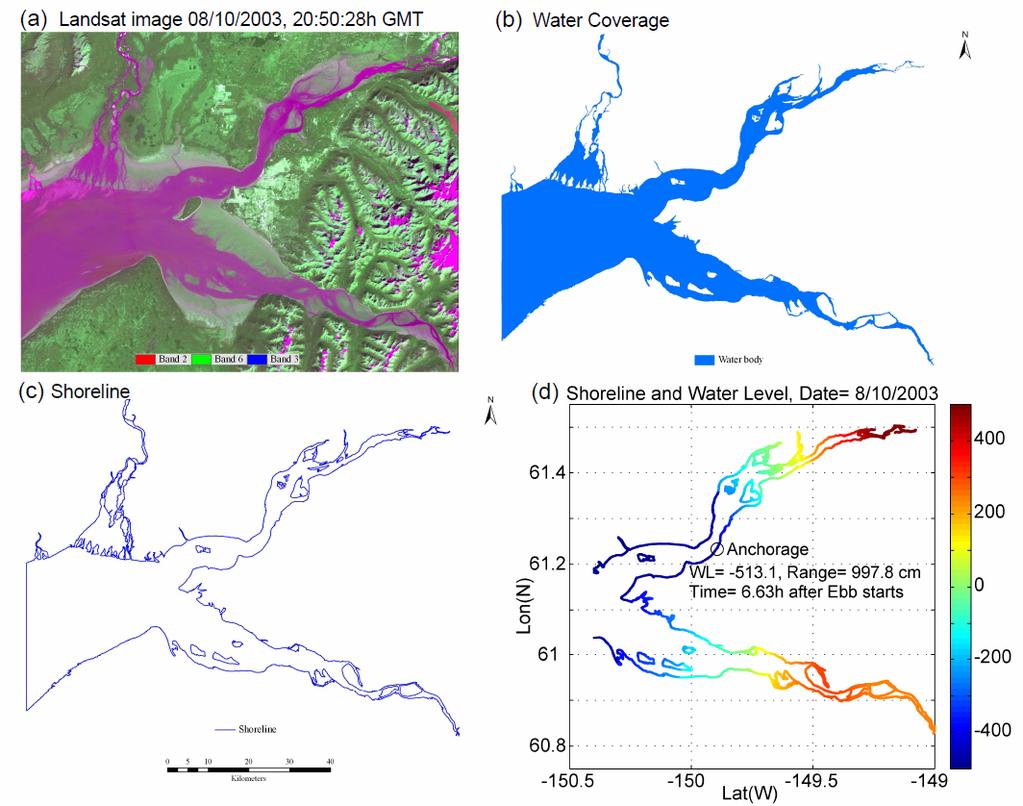
17 Remote Sensing Data Processing (samples from larger data set with many more images) Landsat Thematic Mapper (TM), Landsat Enhanced Thematic Mapper Plus (ETM+)
 in order to improve flood prediction Landsat-ETM+ images during low and high")
18 The inundation model lacks data on the shallow topography of the mudflats, so we have combined the model and remote sensing data (MODIS & Landsat in past studies, SPOT in the future) in order to improve flood prediction Landsat-ETM+ images during low and high tides
19 Remote Sensing Data Processing (Cont.) Geocorrection Reference: USGS digital raster graphics (DRGs) as reference. Supervised image classification Classes: water, wetland, & others. Image refinement. Image recoding Water & non-water.
20 Remote Sensing Data Processing (Cont.) Deriving the coordinates of water pixels along the shoreline. Using the coordinates as inputs to water level prediction.
21
22 How to project water level on shoreline? One way: run the 3D numerical model for each satellite image time too computationally expensive! Simpler way: use model statistics to form an analytical prediction (extrapolate WL from Anchorage to rest of upper CI) Water Level Prediction: η(x,y,t)=η obs (t)a 1 (x,y)cos[b 1 (x,y)]+c 1 (x,y) for Knik Arm η(x,y,t)=η obs (t)a 2 (x,y)cos[b 2 (x,y)]+c 2 (x,y) for Turnagain Arm η obs =observed WL in Anchorage A, B, C = empirical parameters obtained from the statistics of the inundation model

23 amplitude Knik Arm Anchorage Turnagain Arm phase Use these statistics to derive the coefficients for the prediction equation correlation between Anchorage and station 4

24 TESTING THE PREDICTION MODEL Numerical model high tide low tide Analytical prediction formula
25 Applications of the inundation modelremote sensing analysis: Studying the tidal cycle and calculating the area of the flooded zone Studying long-term morphological changes Derive new mudflat topography Evaluate model predicted WAD
26 EBB Shoreline and water level during one tidal cycle FLOOD


27 A1 A5 A4 A3 A2 A2 A4 A1 Water Level A3 A5 The inundated area of the mudflats were calculated for 5 sub-regions from the satellite data
28 Observing long-term morphological changes in the mudflats (all images taken ~2h after flood started in Anchorage) southern channel flow in the 1980s northern channel flow in the 2000s

29 3D CI topography derived from combining ~25 satellite images for inundated regions with model topography for deep regions


30 Eventually, the remote sensing analysis can be used to produce better topography for high resolution inundation models


31 Do Beluga Whale strandings relate to unexpected morphology changes? We are working with NOAA/Fisheries to use our remote sensing data to study this possibility
32 Discussions The limitations in spatial & temporal resolutions of Landsat data requires an integrated approach Combining available satellite data with different acquisition dates and times with sea level data from observations and from model simulations The methodology can be implemented for many other regions, for improving flood predictions and for studying coastal sea level change
33 Thank You!
On the Movement of Beluga Whales in Cook Inlet, Alaska: Simulations of Tidal and Environmental Impacts Using a Hydrodynamic Inundation Model
 Old Dominion University ODU Digital Commons CCPO Publications Center for Coastal Physical Oceanography 1-008 On the Movement of Beluga Whales in Cook Inlet, Alaska: Simulations of Tidal and Environmental
Tides. Tides: longest waves. or seas. or ripples
 Tides or ripples or seas Tides: longest waves Tides Definition: The rise and fall of sea level due to the gravitational forces of the Moon and Sun and the rotation of the Earth. Why tides are important?
Predicting physical-biological interactions in high-latitude marine
 1 2 Proceedings of the 28 th Lowell Wakefield Fisheries Symposium: Responses of Arctic Marine Ecosystems to Climate Change. 3 4 5 6 Predicting physical-biological interactions in high-latitude marine ecosystems.
Training program on Modelling: A Case study Hydro-dynamic Model of Zanzibar channel
 Training program on Modelling: A Case study Hydro-dynamic Model of Zanzibar channel Mayorga-Adame,C.G., Sanga,I.P.L., Majuto, C., Makame, M.A., Garu,M. INTRODUCTION Hydrodynamic Modeling In understanding
Modeling 3D circulation in the Choctawhatchee Bay and River System
 Modeling 3D circulation in the Choctawhatchee Bay and River System Rosemary Cyriac 1, Casey Dietrich 1, Arash Fathi 2, Clint Dawson 2, Kendra Dresback 3, Cheryl Ann Blain 4, Matthew Bilskie 5, Scott Hagen
Baroclinic tidal flows and inundation processes in Cook Inlet, Alaska: numerical modeling and satellite observations
 Ocean Dynamics (2007) 57: 205 221 DOI 10.1007/s10236-007-0103-8 Lie-Yauw Oey. Tal Ezer. Chuanmin Hu. Frank E. Muller-Karger Baroclinic tidal flows and inundation processes in Cook Inlet, Alaska: numerical
Modeling changes to the historic Lower Columbia River Estuary using Delft3D. Drew Mahedy Lumas Helaire Stefan Talke David Jay May 30, 2014
 Modeling changes to the historic Lower Columbia River Estuary using Delft3D Drew Mahedy Lumas Helaire Stefan Talke David Jay May 30, 2014 Comparison: Historic and Modern LCRE US Coastal Survey, 1868 Historic
Feasibility Study for Dredging of Khaprabhanga Chapalir Don River in Patuakhali District for Improvement of Navigability
 IOSR Journal of Engineering (IOSRJEN) ISSN (e): 2250-3021, ISSN (p): 2278-8719 Vol. 04, Issue 06 (June. 2014), V3 PP 32-38 www.iosrjen.org Feasibility Study for Dredging of Khaprabhanga Chapalir Don River
OCN 201 Tides. Tsunamis, Tides and other long waves
 OCN 201 Tides Tsunamis, Tides and other long waves Storm surges Caused by winds and low atmospheric pressure associated with large storms Can raise sea surface by up to 25 ft, bottom contours magnify effect
NOAA NTHMP Mapping & Modeling Subcommittee Benchmarking Workshop: Tsunami Current. NEOWAVE Validation
 NOAA NTHMP Mapping & Modeling Subcommittee Benchmarking Workshop: Tsunami Current NEOWAVE Validation Yefei Bai, Yoshiki Yamazaki, and Kwok Fai Cheung Department of Ocean and Resources Engineering University
APPENDIX A Hydrodynamic Model Qualicum Beach Waterfront Master Plan
 Page 1 of 21 CLIENT: Town of Qualicum Beach PROJECT: SIGNATURE DATE CONTRIBUTORS : M. Marti Lopez REVIEWED BY : P. St-Germain, EIT APPROVED BY: J. Readshaw, P.Eng ISSUE/REVISION INDEX Issue Details Code
2016 NC Coastal Local Governments Annual Meeting
 2016 NC Coastal Local Governments Annual Meeting Coastal Flood Study Modeling and Mapping 101 April 21, 2016 Tom Langan, PE, CFM Engineering Supervisor NCEM Floodplain Mapping Program FEMA Coastal Flood
SOME WATER CHARACTERISTICS OF ESTUARIES IN INDONESIA
 SOME WATER CHARACTERISTICS OF ESTUARIES IN INDONESIA by HENK L. UKTOLSEYA 1 ABSTRACT This paper describes the results obtained during several hydro-oceanographical observations of some estuaries in Indonesia
The impact of ocean bottom morphology on the modelling of long gravity waves from tides and tsunami to climate
 The impact of ocean bottom morphology on the modelling of long gravity waves from tides and tsunami to climate Christian Le Provost and Florent Lyard Laboratoire d Etudes en Géophysique et Océanographie
MIKE 21 Toolbox. Global Tide Model Tidal prediction
 MIKE 21 Toolbox Global Tide Model Tidal prediction MIKE Powered by DHI 2017 DHI headquarters Agern Allé 5 DK-2970 Hørsholm Denmark +45 4516 9200 Telephone +45 4516 9333 Support +45 4516 9292 Telefax mike@dhigroup.com
Simulation of hydraulic regime and sediment transport in the Mekong delta coast
 Simulation of hydraulic regime and sediment transport in the Mekong delta coast 1. Introduction Coastal erosion in the Mekong Delta has been recorded in recent years and the erosion rate has been increasing
Figure 4, Photo mosaic taken on February 14 about an hour before sunset near low tide.
 The Impact on Great South Bay of the Breach at Old Inlet Charles N. Flagg and Roger Flood School of Marine and Atmospheric Sciences, Stony Brook University Since the last report was issued on January 31
The Importance of Mina site within Mecca urban cover change between 1998 and 2013
 FINAL INTERNSHIP REPORT Internship in Urban Remote Sensing Period: February through May 2015 Company: Starlab Ltd, UK The Importance of site within Mecca urban cover change between 1998 and 2013 Author
An Investigation of the Influence of Waves on Sediment Processes in Skagit Bay
 DISTRIBUTION STATEMENT A. Approved for public release; distribution is unlimited. An Investigation of the Influence of Waves on Sediment Processes in Skagit Bay Geoffrey W. Cowles School for Marine Science
SEASONDE DETECTION OF TSUNAMI WAVES
 SEASONDE DETECTION OF TSUNAMI WAVES Belinda Lipa, John Bourg, Jimmy Isaacson, Don Barrick, and Laura Pederson 1 I. INTRODUCTION We here report on preliminary results of a study to assess the capability
Earth s oceans covers 71 % _ of the planet s surface. In reality, Earth s ocean waters are all. interconnected as part of a single large global ocean.
 Ocean Motion Met 101: Introduction to the World's Oceans Produced by The COMET Program Geography: Name Pd. Earth s oceans covers 71 % _ of the planet s surface. In reality, Earth s ocean waters are all
Yellow Sea with contributions by John R. Apel
 with contributions by John R. Apel Overview The is a shallow inland sea lying between northeastern China and the Korean Peninsula, with depths in its central north-south trough in excess of 60 to 80 m
CALCASIEU SALINITY STRUCTURES. HYDRODYNAMIC MODELING (To Support Design of Salinity Barriers)
") CALCASIEU SALINITY STRUCTURES HYDRODYNAMIC MODELING (To Support Design of Salinity Barriers) Presentation Overview 1 2 3 4 5 Project Overview and CEA Circulation Modeling Vessel Hydrodynamics Modeling
CALCASIEU SALINITY STRUCTURES HYDRODYNAMIC MODELING (To Support Design of Salinity Barriers) Presentation Overview 1 2 3 4 5 Project Overview and CEA Circulation Modeling Vessel Hydrodynamics Modeling
Interactions of Waves and River Plume and their Effects on Sediment Transport at River Mouth
 DISTRIBUTION STATEMENT A. Approved for public release; distribution is unlimited. Interactions of Waves and River Plume and their Effects on Sediment Transport at River Mouth Tian-Jian Hsu and Fengyan
Announcements. Project 2 due Nov 7 th Topics for today: Big waves. Tsunamis, seiches and tidal waves. Tsunamis and seiches
 Announcements Project 2 due Nov 7 th Topics for today: Big waves Tsunamis, seiches and tidal waves Tsunamis and seiches Seiche: standing wave that rocks back and forth within an enclosed or semi-enclosed
Development of SAR-Derived Ocean Surface Winds at NOAA/NESDIS
 Development of SAR-Derived Ocean Surface Winds at NOAA/NESDIS Pablo Clemente-Colón, William G. Pichel, NOAA/NESDIS Frank M. Monaldo, Donald R. Thompson The Johns Hopkins University Applied Physics Laboratory
Pathogen Transport in Coastal Environments: Case Studies of Urban Runoff in Southern California
 Pathogen Transport in Coastal Environments: Case Studies of Urban Runoff in Southern California A presentation to the Center for Water Sciences MSU Pathogens Workshop, April 20, 2007 Stanley B. Grant Henry
Predicting wave conditions in a coral embayment from offshore directional spectral model input
 Predicting wave conditions in a coral embayment from offshore directional spectral model input Ron Hoeke 1,2 and Curt Storlazzi 3 1 Coral Reef Ecosystem Division (CRED) NOAA Pacific Islands Fisheries Science
Exploring Localized Mixing Dynamics During Wet Weather in a Tidal Fresh Water System
 Exploring Localized Mixing Dynamics During Wet Weather in a Tidal Fresh Water System Ramona McCullough & Phil Duzinski Delaware Estuary Science & Environmental Summit January 27, 2015 Background and objectives
Tidal regime along Vietnam coast under impacts of sea level rise
 VNU Journal of Science, Earth Sciences 28 (2012) 133-139 Tidal regime along Vietnam coast under impacts of sea level rise Tran Thuc, Duong Hong Son* Vietnam Institute of Meteorology, Hydrology and Environment
Three-dimensional High-resolution Numerical Study of the Tide and Tidal Current in the Jiaozhou Bay and Olympic Sailing Site
 Three-dimensional High-resolution Numerical Study of the Tide and Tidal Current in the Jiaozhou Bay and Olympic Sailing Site By Jinrui Chen Ocean University of China cooperator: Shiliang Shan, Huaming
THE POLARIMETRIC CHARACTERISTICS OF BOTTOM TOPOGRAPHY RELATED FEATURES ON SAR IMAGES
 THE POLARIMETRIC CHARACTERISTICS OF BOTTOM TOPOGRAPHY RELATED FEATURES ON SAR IMAGES Taerim Kim Professor, Ocean System Eng. Dept. Kunsan University Miryong Dong San 68, Kunsan, Jeonbuk, Korea, trkim@kunsan.ac.kr
consulting engineers and scientists
 consulting engineers and scientists Coastal Processes Presented by: January 9, 2015 Varoujan Hagopian, P.E. F.ASCE Senior Consultant, Waterfront Engineer Living Shoreline Workshop Lets Remember Why We
SPATIAL AND TEMPORAL VARIATIONS OF INTERNAL WAVES IN THE NORTHERN SOUTH CHINA SEA
 SPATIAL AND TEMPORAL VARIATIONS OF INTERNAL WAVES IN THE NORTHERN SOUTH CHINA SEA Weigen Huang (1), Johnny Johannessen (2,3), Werner Alpers (4) Jingsong Yang (1), Xilin Gan (1) (1) Second Institute of
Coastal Sediment Transport Modeling Ocean Beach & San Francisco Bight, CA
 1 Coastal Sediment Transport Modeling Ocean Beach & San Francisco Bight, CA Honghai Li and Lihwa Lin Engineering Research and Development Center U.S. Army Corps of Engineers Frank Wu, Lisa Andes, and James
Global Ocean Internal Wave Database
 Global Ocean Internal Wave Database Victor Klemas Graduate College of Marine Studies University of Delaware Newark, DE 19716 phone: (302) 831-8256 fax: (302) 831-6838 email: klemas@udel.edu Quanan Zheng
Comparative Study of Satellite Images Performance in Mapping Lake Bathymetry: Case Study of Al-Manzala Lake, Egypt
 American Journal of Geographic Information System 2018, 7(3): 82-87 DOI: 10.5923/j.ajgis.20180703.02 Comparative Study of Satellite Images Performance in Mapping Lake Bathymetry: Case Study of Al-Manzala
Wind Atlas for the Gulf of Suez Satellite Imagery and Analyses
 Downloaded from orbit.dtu.dk on: Nov 09, 2017 Wind Atlas for the Gulf of Suez Satellite Imagery and Analyses Hasager, Charlotte Bay Publication date: 2003 Document Version Publisher's PDF, also known as
The Impact on Great South Bay of the Breach at Old Inlet Charles N. Flagg School of Marine and Atmospheric Sciences, Stony Brook University
 The Impact on Great South Bay of the Breach at Old Inlet Charles N. Flagg School of Marine and Atmospheric Sciences, Stony Brook University This is the sixth in a series of reports describing the evolution
Challenges in determining water surface in airborne LiDAR topobathymetry. Amar Nayegandhi, Dewberry 15 th Annual JALBTCX Workshop, June 11 th 2014
 Challenges in determining water surface in airborne LiDAR topobathymetry Amar Nayegandhi, Dewberry 15 th Annual JALBTCX Workshop, June 11 th 2014 Why topobathy LiDAR? Complements acoustic (multi-beam sonar)
Inlet Management Study for Pass-A-Grille and Bunces Pass, Pinellas County, Florida
 Inlet Management Study for Pass-A-Grille and Bunces Pass, Pinellas County, Florida Final Report Submitted By Ping Wang, Ph.D., Jun Cheng Ph.D., Zachary Westfall, and Mathieu Vallee Coastal Research Laboratory
Impact of the tides, wind and shelf circulation on the Gironde river plume dynamics
 Impact of the tides, wind and shelf circulation on the Gironde river plume dynamics F. Toublanc 1, N. Ayoub 2, P. Marsaleix 3, P. De Mey 2 1 CNES/LEGOS 2 CNRS/LEGOS 3 CNRS/LA, Toulouse, France 5th GODAE
Theory and Application Introductory Oceanography Ray Rector: Instructor
 OCEAN TIDES Theory and Application Introductory Oceanography Ray Rector: Instructor Tidal Concepts Tides are extremely swift, very long-wavelength, shallow-water waves Tides are periodic short-term changes
Preliminary Wake Wash Impact Analysis Redwood City Ferry Terminal, Redwood City, CA
 Technical Memorandum Preliminary Wake Wash Impact Analysis Redwood City Ferry Terminal, Redwood City, CA 1. Introduction The following preliminary wake wash impact analysis was initiated by the Port of
Effect of Hydrodynamics on Sediment Transport near a Coastal Inlet
 ICHE 2014, Hamburg - Lehfeldt & Kopmann (eds) - 2014 Bundesanstalt für Wasserbau ISBN 978-3-939230-32-8 Effect of Hydrodynamics on Sediment Transport near a Coastal Inlet H. Li, M. Brown, J. Rosati & Z.
CHAPTER 8 ASSESSMENT OF COASTAL VULNERABILITY INDEX
 124 CHAPTER 8 ASSESSMENT OF COASTAL VULNERABILITY INDEX 8.1 INTRODUCTION In order to assess the vulnerability of the shoreline considered under this study against the changing environmental conditions,
K V Thomas Centre for Earth Science Studies, Thiruvananthapuram , India
 Setback lines for Coastal Regulation Zone Different approaches and implications K V Thomas Centre for Earth Science Studies, Thiruvananthapuram - 695031, India Email: thomas.cess@gmail.com 1.0 Introduction
Computational Analysis of Oil Spill in Shallow Water due to Wave and Tidal Motion Madhu Agrawal Durai Dakshinamoorthy
 Computational Analysis of Oil Spill in Shallow Water due to Wave and Tidal Motion Madhu Agrawal Durai Dakshinamoorthy 1 OUTLINE Overview of Oil Spill & its Impact Technical Challenges for Modeling Review
Uncertainty Estimates in Satellite Derived Bathymetry
 Uncertainty Estimates in Satellite Derived Bathymetry Richard Flemmings, TCarta #chcnsc2018 Introduction and Overview 1. TCarta 2. Satellite Derived Bathymetry Overview 3. Satellite Derived Bathymetry
RIP CURRENTS. Award # N
 RIP CURRENTS Graham Symonds School of Geography and Oceanography University College, University of New South Wales, Australian Defence Force Academy, Canberra, 2600 AUSTRALIA Phone: 61-6-2688289 Fax: 61-6-2688313
Applications of ELCIRC at LNEC
 stratification in the Guadiana estuary tidal propagation in the Óbidos lagoon Lígia Pinto Anabela Oliveira André B. Fortunato 2 O utline Stratification in the Guadiana estuary The Guadiana estuary Objectives
Hydrologic Feasibility of Storm Surge Barriers
 Hydrologic Feasibility of Storm Surge Barriers Malcolm J. Bowman, School of Marine and Atmospheric Sciences State University of New York, Stony Brook, NY. Presented at Against the Deluge: Storm Surge Barriers
Development and Implementation of a Relocatable Coastal and Nearshore Modeling System
 Development and Implementation of a Relocatable Coastal and Nearshore Modeling System James M. Kaihatu Zachry Department of Civil Engineering, Texas A&M University 3136 TAMU College Station, TX 77843-3136
SURFACE CURRENTS AND TIDES
 NAME SURFACE CURRENTS AND TIDES I. Origin of surface currents Surface currents arise due to the interaction of the prevailing wis a the ocean surface. Hence the surface wi pattern (Figure 1) plays a key
Beach Wizard: Development of an Operational Nowcast, Short-Term Forecast System for Nearshore Hydrodynamics and Bathymetric Evolution
 Beach Wizard: Development of an Operational Nowcast, Short-Term Forecast System for Nearshore Hydrodynamics and Bathymetric Evolution Ad Reniers Civil Engineering and Geosciences, Delft University of Technology
Super-parameterization of boundary layer roll vortices in tropical cyclone models
 DISTRIBUTION STATEMENT A. Approved for public release; distribution is unlimited. Super-parameterization of boundary layer roll vortices in tropical cyclone models PI Isaac Ginis Graduate School of Oceanography
The Surge of the Storm By Margaret Olsen and Katie Greganti
 The Surge of the Storm By Margaret Olsen and Katie Greganti Grade Level: 5-12 Type of Activity: Hands on Focus Question: How does a hurricane s storm surge of a hurricane affect the low-lying areas along
Beach Profiles. Topics. Module 9b Beach Profiles and Crossshore Sediment Transport 3/23/2016. CE A676 Coastal Engineering
 Beach Profiles AND CROSS-SHORE TRANSPORT Orson P. Smith, PE, Ph.D., Professor Emeritus Topics Features of beach and nearshore profiles Equilibrium profiles Cross-shore transport References Text (Sorensen)
Observations of hydrography and currents in central Cook Inlet, Alaska during diurnal and semidiurnal tidal cycles
 OCS STUDY MMS 2004-058 Final Report Observations of hydrography and currents in central Cook Inlet, Alaska during diurnal and semidiurnal tidal cycles by Stephen R. Okkonen Institute of Marine Science
Unit 11 Lesson 2 How Does Ocean Water Move? Copyright Houghton Mifflin Harcourt Publishing Company
 Unit 11 Lesson 2 How Does Ocean Water Move? Catch a Wave A wave is the up-and-down movement of surface water. Catch a Wave Catch a Wave (wave effects) Surface waves are caused by wind pushing against
The construction of Deepwater Navigation Channel (DNC) in the Bystry arm of the Danube Delta has started in The whole project provides the
 in the Bystry arm of the Danube Delta has started in The whole project provides the") Annex 45 Numerical Studies of Waves, Currents and Sediment Transport at the Marine Part of Deepwater Navigation Channel through the Bystry Arm of the Danube Delta and Model Verification based on Laboratory
Annex 45 Numerical Studies of Waves, Currents and Sediment Transport at the Marine Part of Deepwater Navigation Channel through the Bystry Arm of the Danube Delta and Model Verification based on Laboratory
Modelling and Assessment of Marine Renewable Energy Resources. Andrew Cornett Canadian Hydraulics Centre National Research Council Canada May 2008
 Modelling and Assessment of Marine Renewable Energy Resources Andrew Cornett Canadian Hydraulics Centre National Research Council Canada May 2008 Background Pan-Canadian resource inventory in 2005/06 Canada
Radar Remote Sensing of Waves and Episodic Flow Events
 DISTRIBUTION STATEMENT A. Approved for public release; distribution is unlimited. Radar Remote Sensing of Waves and Episodic Flow Events PI: Merrick C. Haller 220 Owen Hall Oregon State University Corvallis,
MAR 555 Lecture 20: Coastal Tides
 MAR 555 Lecture 20: Coastal Tides Tides caused by the resulting gravitational and centrifugal forces is called equilibrium tide. They can be expressed using the harmonic functions as N semi! e(semi) =
An Atlas of Oceanic Internal Solitary Waves (February 2004) by Global Ocean Associates Prepared for Office of Naval Research Code 322 PO
 by Global Ocean Associates Prepared for Office of Naval Research Code 322 PO") Overview The is located in the North Atlantic Ocean between southern Ireland and southwest England (Figure 1). The Sea s western edge covers a continental shelf region characterized by rough and irregular
Overview The is located in the North Atlantic Ocean between southern Ireland and southwest England (Figure 1). The Sea s western edge covers a continental shelf region characterized by rough and irregular
SCIENCE OF TSUNAMI HAZARDS
 SCIENCE OF TSUNAMI HAZARDS ISSN 8755-6839 Journal of Tsunami Society International Volume 29 Number 3 2010 ESTIMATION OF EXPECTED MAXIMUM WATER LEVEL DUE TO TIDE AND TSUNAMI INTERACTION ALONG THE COASTAL
OFFICE OF STRUCTURES MANUAL FOR HYDROLOGIC AND HYDRAULIC DESIGN CHAPTER 11 APPENDIX B TIDEROUT 2 USERS MANUAL
 OFFICE OF STRUCTURES MANUAL FOR HYDROLOGIC AND HYDRAULIC DESIGN CHAPTER 11 APPENDIX B TIDEROUT 2 USERS MANUAL APRIL 2011 APRIL 2011 Page 1 Preface TIDEROUT 2, Build 1.22 dated June 29, 2006 is the current
INTRODUCTION TO COASTAL ENGINEERING
 The University of the West Indies Organization of American States PROFESSIONAL DEVELOPMENT PROGRAMME: COASTAL INFRASTRUCTURE DESIGN, CONSTRUCTION AND MAINTENANCE A COURSE IN COASTAL DEFENSE SYSTEMS I CHAPTER
Pathways Interns: Annika O Dea, Ian Conery, Andrea Albright
 1 REMOTE SENSING OF COASTAL MORPHODYNAMICS 237 237 237 217 217 217 2 2 2 8 119 27 252 174.59 255 255 255 163 163 163 131 132 122 239 65 53 11 135 12 112 92 56 62 12 13 12 56 48 13 12 111 Kate Brodie Brittany
INTRODUCTION TO COASTAL ENGINEERING AND MANAGEMENT
 Advanced Series on Ocean Engineering Volume 16 INTRODUCTION TO COASTAL ENGINEERING AND MANAGEMENT J. William Kamphuis Queen's University, Canada World Scientific Singapore New Jersey London Hong Kong Contents
An IOOS Operational Wave Observation Plan Supported by NOAA IOOS Program & USACE
 An IOOS Operational Wave Observation Plan Supported by NOAA IOOS Program & USACE R.E. Jensen, W.A. Birkemeier and W. Burnett JCOMM-Workshop on Wave Measurements from Buoys Wave Information to Application
LONG WAVES OVER THE GREAT BARRIER REEF. Eric Wolanski ABSTRACT
 LONG WAVES OVER THE GREAT BARRIER REEF by Eric Wolanski k ABSTRACT Low-frequency forcing of water currents over the continental shelf f Australia is quite strong and should be taken into account when the
4/06/2014. Need for Guidance. East Coast Lows. Catchment and coastal flood events can combine! Project 18 ARR Review
 Need for Guidance Development of Practical Guidance for Coincidence of Catchment Flooding and Oceanic Inundation Angela Toniato, NSW OEH Duncan McLuckie, NSW OEH Grantley Smith, Water Research Laboratory
Geostrophic and Tidal Currents in the South China Sea, Area III: West Philippines
 Southeast Asian Fisheries Development Center Geostrophic and Tidal Currents in the South China Sea, Area III: West Philippines Anond Snidvongs Department od Marine Science, Chulalongkorn University, Bangkok
TIDES. Theory and Application
 TIDES Theory and Application Tidal Concepts Tides are extremely swift, very long-wavelength, shallow-water waves Tides are periodic short-term changes in sea level at a particular place caused by the gravitational
3/9/2013. Build house on cliff for a view of the ocean - be one with said view Pearson Education, Inc. Shorelines: summary in haiku form
 Introduction to Environmental Geology, 5e Edward A. Keller Shorelines: summary in haiku form Chapter 11 Coastal Processes Lecture Presentation prepared by X. Mara Chen, Salisbury University Build house
Real Time (RT) Snow Water Equivalent (SWE) Simulation April 14, 2014 Sierra Nevada Mountains, California
 Snow Water Equivalent (SWE) Simulation April 14, 2014 Sierra Nevada Mountains, California") Real Time (RT) Snow Water Equivalent (SWE) Simulation April 14, 2014 Sierra Nevada Mountains, California Abstract On April 14 th, percent of average SWE values for this date have decreased to 10% for the
Real Time (RT) Snow Water Equivalent (SWE) Simulation April 14, 2014 Sierra Nevada Mountains, California Abstract On April 14 th, percent of average SWE values for this date have decreased to 10% for the
WMS 8.4 Tutorial Hydraulics and Floodplain Modeling HY-8 Modeling Wizard Learn how to model a culvert using HY-8 and WMS
 v. 8.4 WMS 8.4 Tutorial Hydraulics and Floodplain Modeling HY-8 Modeling Wizard Learn how to model a culvert using HY-8 and WMS Objectives Define a conceptual schematic of the roadway, invert, and downstream
Questions # 4 7 refer to Figure # 2 (page 321, Fig )
") Shoreline Community College OCEANOGRAPHY 101 Fall 2006 Sample Exam # 3 Instructor: Linda Khandro Questions # 1 3 refer to Figure # 1 (page 284, Fig 11.7) 1. At which position is the moon in its new moon
Shoreline Community College OCEANOGRAPHY 101 Fall 2006 Sample Exam # 3 Instructor: Linda Khandro Questions # 1 3 refer to Figure # 1 (page 284, Fig 11.7) 1. At which position is the moon in its new moon
: Hydrodynamic input for 2D Vessel Simulations (HY- 0027)
") Technical Note To : Christian Taylor (PoHDA) From : Rohan Hudson Cc : Ben Gray Date : 1/04/2015 (Final Draft) Subject : Hydrodynamic input for 2D Vessel Simulations (HY- 0027) Introduction This Technical
Technical Note To : Christian Taylor (PoHDA) From : Rohan Hudson Cc : Ben Gray Date : 1/04/2015 (Final Draft) Subject : Hydrodynamic input for 2D Vessel Simulations (HY- 0027) Introduction This Technical
Geography of the Lower Fitzroy and navigation problems
 Geography of the Lower Fitzroy and navigation problems A topographic map of the Fitzroy estuary readily indicates why the Fitzroy River has proved difficult for shipping to negotiate. The river meanders
Real Time (RT) Snow Water Equivalent (SWE) Simulation May 26, 2014 Sierra Nevada Mountains, California
 Snow Water Equivalent (SWE) Simulation May 26, 2014 Sierra Nevada Mountains, California") Real Time (RT) Snow Water Equivalent (SWE) Simulation May 26, 2014 Sierra Nevada Mountains, California Abstract On May 26 th, percent of average SWE values for this date have shown an increase to 0.5%
Real Time (RT) Snow Water Equivalent (SWE) Simulation May 26, 2014 Sierra Nevada Mountains, California Abstract On May 26 th, percent of average SWE values for this date have shown an increase to 0.5%
Tsunamis are not observed via height rather by orbital velocity from shallow-water wave physics
 Modeling of Tsunami Current Flows Presenter: Dr. Don Barrick President, CODAR Ocean Sensors Coauthors: Dr. Belinda Lipa, Chad Whelan RIAM Workshop on Oceanographic Radar Tsunami capability of HF radar
Evaluation of MODIS chlorophyll algorithms in
 Evaluation of MODIS chlorophyll algorithms in Australian continental shelf waters: The IMOS match up data base Schroeder T, Lovell J,, Clementson L, King E, Brando V 9 July 2014 Australian Marine Science
Name Class Date. Use the terms from the following list to complete the sentences below. Each term may be used only once. Some terms may not be used.
 Assessment Chapter Test B The Movement of Ocean Water USING KEY TERMS Use the terms from the following list to complete the sentences below. Each term may be used only once. Some terms may not be used.
G. Meadows, H. Purcell and L. Meadows University of Michigan
 www.coj.net/departments/fire+and+rescue/emergency+preparedness/rip+current.htm G. Meadows, H. Purcell and L. Meadows Over 80% of all surf related rescues are attributable to Rip Currents According to the
ISOLATION OF NON-HYDROSTATIC REGIONS WITHIN A BASIN
 ISOLATION OF NON-HYDROSTATIC REGIONS WITHIN A BASIN Bridget M. Wadzuk 1 (Member, ASCE) and Ben R. Hodges 2 (Member, ASCE) ABSTRACT Modeling of dynamic pressure appears necessary to achieve a more robust
Tide and Tidal Current in the Mahakam Estuary, East Kalimantan, Indonesia
 Coastal Marine Science 32(1): 1 8, 2008 Tide and Tidal Current in the Mahakam Estuary, East Kalimantan, Indonesia Idris MANDANG 1 * and Tetsuo YANAGI 2 1 Interdisciplinary Graduate School of Engineering
Hydrodynamic Modeling of Tides and Hurricane Storm Surge for Pre- and Post-Dredging Conditions in the Lower St. Johns River, Florida
 Hydrodynamic Modeling of Tides and Hurricane Storm Surge for Pre- and Post-Dredging Conditions in the Lower St. Johns River, Florida Matthew V. Bilskie 1 1 PhD Student, University of Central Florida, Department
Warm-up # 7 A day 5/17 - B day 5/18 UPDATE YOUR TABLE OF CONTENTS
 Warm-up # 7 A day 5/17 - B day 5/18 UPDATE YOUR TABLE OF CONTENTS Question: List all examples of surface water on Earth. Answer: Rivers and streams, lakes and reservoirs, (ponds) wetlands, estuaries and
The Oregon Coast Education Program. Concepts to Teach: Tidal cycles, interconnectedness and balance
 Tides of the Estuary Adapted from TIDES Activity 4- South Slough NERR Time requirement: 45 minutes Summary of Activity: This lesson is designed to give an introduction to how tides and tidal cycles work
Monetisation of sustainable business models for Satellite Derived Bathymetry
 Monetisation of sustainable business models for Satellite Derived Bathymetry Who are we? We are a UK & UAE based company specialising in satellite derived seabed & environmental mapping products We aim
Reply of Guyana Annex R2
 Summary of Findings: Analysis of Recent Shoreline Revisions to the This report assesses recent shoreline changes made to the 2005 edition of Dutch nautical chart NL 2218. This new edition is credited jointly
Survival in an Estuary. Life in a Transition Zone
 Estuary An estuary is a semi-enclosed coastal body of water which has a free connection with the open sea and within which sea water is measurably diluted with fresh water derived from land drainage. (D.
Wave Energy Research and Applications
 Wave Energy Research and Applications Shoreline and Shallows conference East Lansing, MI March 7, 2019 Photo: Dave Sanford Waves Background 1. Types of Waves 2. Good and Bad Waves 3. Restoration Impacts
Effects of Offshore Forcing in the Nearshore Environment
 Effects of Offshore Forcing in the Nearshore Environment Geno Pawlak Department of Ocean and Resources Engineering University of Hawaii at Manoa 2540 Dole St., Holmes Hall 402 Honolulu, HI 96822 phone:
RIVET Satellite Remote Sensing and Small Scale Wave Process Analysis
 DISTRIBUTION STATEMENT A. Approved for public release; distribution is unlimited. RIVET Satellite Remote Sensing and Small Scale Wave Process Analysis Hans C. Graber RSMAS Department of Ocean Sciences
MODELING OF CLIMATE CHANGE IMPACTS ON COASTAL STRUCTURES - CONTRIBUTION TO THEIR RE-DESIGN
 Proceedings of the 14 th International Conference on Environmental Science and Technology Rhodes, Greece, 3-5 September 2015 MODELING OF CLIMATE CHANGE IMPACTS ON COASTAL STRUCTURES - CONTRIBUTION TO THEIR
Boost Your Skills with On-Site Courses Tailored to Your Needs
 Boost Your Skills with On-Site Courses Tailored to Your Needs www.aticourses.com The Applied Technology Institute specializes in training programs for technical professionals. Our courses keep you current
Climate Change Scenarios for the Agricultural and Hydrological Impact Studies
 Climate Change Scenarios for the Agricultural and Hydrological Impact Studies Martin Dubrovský (WP 3, 5, 6) hotel Mendi, Halkidiki, Greece ***** 10-12. June 2009 scheme of cc impacts study GCM output obs.wea.series