Nothing So Constant as Change
|
|
|
- Shanon Brooks
- 5 years ago
- Views:
Transcription
 More than 20,000 years ago glaciers covered the Great Lakes area and were over a mile thick.")
 was deposited in layers of gravel, sand, and clay in different combinations.")


1 Nothing So Constant as Change By Ron Schaper Dynamic Environments 1) Lake Levels 2) Beach Size 3) Cliff Erosion 4) Beach and Cliff Plant Communities 1) Lake Levels (Michigan/Huron) More than 20,000 years ago glaciers covered the Great Lakes area and were over a mile thick. Glaciers started to melt about 15,000 years ago, which formed the Great Lakes and deposited immense quantities of boulders, rocks, gravel, sand, and clay known as glacial till. This till (soil) was deposited in layers of gravel, sand, and clay in different combinations. As the glaciers continued their retreat the Lakes had a series of different levels. The present average Lake Michigan/Huron level is 579 feet above sea level. In the past the levels has been as high as 640 ft. 12,000 years ago and 605 ft. 11,000 yrs. ago as seen in the maps below. Since then there has been a series of different levels which have left marks on the landscape. The graph below illustrates approximate Lake Levels over the last 5000 years. About 4,500 yrs. ago the level was about 593 ft. and in next 1000 years fell to a present average level of 579 ft. The last 3,500 yrs. the levels have fluctuated 4 ft. above the average of 579 ft. and 3 ft. below the average. As the climate continues to change Lake Levels will continue to fluctuate.


2 Since record keeping started over 120 years ago Lake Michigan/Huron has fluctuated 3 ft. above and 3 ft. below an average of 579 ft. as the two graphs below illustrate. These Lake Level changes of the past 120 years are in the normal range for the last 3,500 years. This is what Lake Levels do. They erode the land containing them and their levels fluctuate with time which is caused by short and long term trends of climate. Headlines tend to sensationalize high or low Lake Levels.

 B) Drainage Out 68% of Water Loss + (Dredging St.")
 C) Evaporation 32% of Water Loss (Amount of Ice")

3 Factors of Lake Levels A) Drainage into Lakes 100% Precipitation (Seasonal average winter low Feb., summer high Aug.) B) Drainage Out 68% of Water Loss + (Dredging St. Clair River extra 2ft. loss over 40 yrs.) C) Evaporation 32% of Water Loss (Amount of Ice coverage major factor) Combined Evaporation/Precipitation The graphs above demonstrate that above normal precipitation wasn t enough to keep Lake Levels up, because there was above normal evaporation.


4 Warmer winters cause less Ice coverage on Lakes and more Evaporation Cooler Period: Ice Coverage s Warmer Period: Less Ice Coverage Great Lakes Had more Ice coverage Lake Michigan Lake Superior Less Evaporation Lost 63% Ice coverage Lost 76% Ice coverage. Increased Evaporation caused lower Lake Levels Ice Reflects Sun s Heat Away No Ice Lake Absorbs Sun s Heat Summary Warmer winters result in less ice coverage causing increased evaporation of Lakes. Less Ice coverage causes increased water temperatures, more evaporation and lower Lake Levels. A major portion of evaporated water does not return to the drainage basin of the Great Lakes and is permanently lost to the Lakes. Without ice coverage the long term trend of Lake Levels is likely to trend lower from the loss of increased evaporation. There will be cyclical interruptions of increasing Lake Levels from time to time.
 Contour of Lake Bottom, Beach Material, Lake Currents, Storms, Wind & Wave Direction, Vegetation Coverage As Lake Levels fall the increase of the")
5 2) Beach Size A) Lake Level Decreases Beach Size Increases (Waves Deposit Materials) B) Lake Level Increases Beach Size Decreases (Waves Erode Materials) Major Factor: Minor Factors: Cyclic Fluctuations of Lake Levels (Climatic fluctuations) Contour of Lake Bottom, Beach Material, Lake Currents, Storms, Wind & Wave Direction, Vegetation Coverage As Lake Levels fall the increase of the beach is not realized immediately. It takes time for waves to deposit material (sand) landward. Equilibrium is established between the Lake Level and the size of beach over a period of time. The reverse is also the case. When Lake Levels rise, it takes time for the waves to erode the beach until equilibrium is established.

 Slumping from Perched Water Table In some areas glaciers deposited an impervious")


6 3) Cliff Erosion A) Lake is at Base of Cliff Waves undercut and remove material causing instability and slumping. Process repeats when slumped cliff material is removed by waves. B) Slumping from Perched Water Table In some areas glaciers deposited an impervious layer of clay near the surface which prevents water from percolating downward. On a cliff face a seep appears and saturates the soils of the cliff, and becomes a fluid- like consistency causing the cliff to slump. This type of erosion tends to happen in spring. During heavy precipitation events, soils of the cliff can become saturated and slumping will occur. Seeps create a wet environment for Phragmites to grow on damp cliffs.


7 Problems Caused by Slumping due to Perched Water Table Rip rap, large boulders, stones, vegetation, etc. will not prevent the process of slumping due to a perched water table. During periods of average to high Lake Levels the material that has slid down the cliff will probably be washed away. If slumped earth is prevented from being washed away by extensive amounts of rip rap at the base of a cliff, cliff erosion will continue by slumping from above because of a perched water table. Stairways constructed will continually need rebuilding due to slumping if built where a perched water table exists.
8 4) Beach and Cliff Plant Communities Beach Plants: Lake cyclically rises and falls- vegetation changes with conditions. Cliff Plants: Cliff erodes-vegetation slides down towards beach. Sources of Vegetation A) Cliff Erosion: (Slumping) Vegetation slides down, top of cliff to lower cliff and beach. B) Seeds in Animal Scat: (birds, mammals, etc.) C) Air-Borne Seeds D) Vegetation and Seeds wash ashore. Some beach vegetation migrates up onto cliff face. E) Existing Seed Bank established from previous vegetation. Dynamic Environments: Lake Levels, Beaches, and Cliffs are Constantly Changing 1) The beach environment is not permanent. The Lake Levels will continue to fluctuate as illustrated. Without ice coverage long term trend of Lake Levels is likely to be lower. There will be interruptions of increasing Lake Levels from time to time. (3ft. Increase of Lake Level in 18 months, ) Lake Level changes of the past 120 years are in the normal range for the last 3,500 years. 2) The beaches and cliffs will take care of themselves. Despite the fluctuations in Lake Levels, changes in beach sizes, the erosion of cliffs, there are diverse sources of vegetation for the beaches and cliffs to revegetate. The vagaries of Lake Levels, Cliff erosion, and Beach instability lead one to conclude, let nature heal itself. Phragmites colonizes beaches mostly by air borne seeds and perhaps some plants washed ashore from other areas. It prefers a damp environment. It colonizes moist cliff areas by seeds and from plants on the beach which follow damp soil up the cliff. Damp soil is from a perched water table seep. Phragmites tends not to colonize on dry cliff areas or dry upper beach areas where other desirable beach grasses and vegetation grow. Availability of moisture limits its range. Phragmites forms extremely dense colonies which crowd out any desirable vegetation and prevent access. Elimination of Phragmites is achieved if all land owners cooperate by having it treated and are vigilant in the future. Any collateral damage of vegetation caused by chemical treatment of Phragmites will revegetate or heal in time. Ron Schaper 5/28/15

.")


9 Phragmites (Extremely Invasive Public Enemy # 1) Very thick colonies Crowds out and kills other plants Wildlife can t penetrate or eat Extensive root system approximately 70% of plant is roots Phragmites spreads primarily by rhizomes (grow over 50 ft. a year). Seeds are dispersed by animals and wind. Seeds land on desirable damp areas and sprout. It outcompetes and eliminates other native species. Killing Phragmites is accomplished by applying a herbicide like RoundUp in the fall when the plant is taking nutrients down to it s roots for next years growth. The herbicide then kills the roots. Applications at other times of the year are not as effective, because the herbicide doesn t get down to the roots to kill the whole plant.


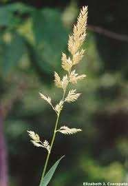
10 Reed Canary Grass ( very invasive)


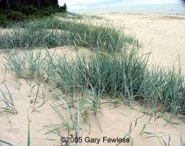
11 Native Plants of the Beach American Beach Grass or Marrum Grass Canada Wild Rye Grass Little Bluestem Sand Reed Grass Switch Grass Lyme Grass (invasive)


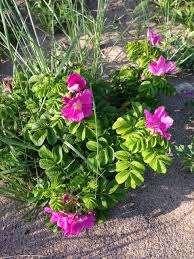
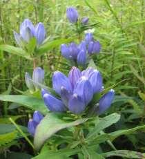
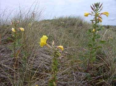
12 Beach Pea Sedum Rose Grass of Parnassus Bottle Gentian Silverweed Cinquefoil Evening Primrose Blue Vervain


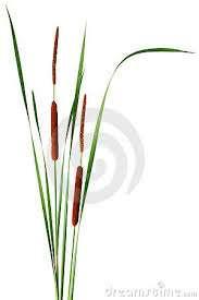
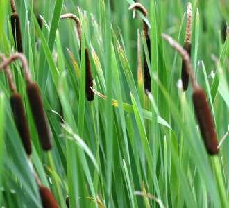
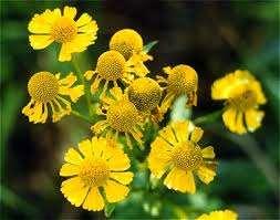

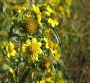
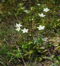
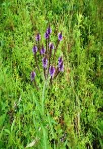
13 Swamp Milkweed Joe Pye Weed Harebell Campanula Narrow-leaved/Hybrid Cattail (invasive) Broadleaf Cattail Sneezeweed Composites (Daisey Family)
Why do different beaches have different types of vegetation?
 Why do different beaches have different types of vegetation? Allan Crowe Environment Canada National Water Research Institute Burlington, Ontario Environment Canada Environnement Canada NATIONAL WATER
UNDERSTANDING YOUR ESTUARY Level IA- ESTUARY SEARCH
 UNDERSTANDING YOUR ESTUARY Level IA- ESTUARY SEARCH Kakagon/Bad River Sloughs, a Lake Superior estuary located on the Bad River Reservation near Ashland, WI. GOAL Select one Wisconsin estuary to study
Marine Ecosystems. Aquatic Ecosystems Section 2
 Marine Ecosystems Marine ecosystems are located mainly in coastal areas and in the open ocean. Organisms that live in coastal areas adapt to changes in water level and salinity. Organisms that live in
Adapting to Climate Change In Coastal Environments
 Adapting to Climate Change In Coastal Environments Peter Nimmrichter, P.Eng. AMEC Earth and Environmental, Mississauga, Ontario 19/11/2007 1 The Great Lakes Watershed The Great Lakes cover an area of 244,160
* Appalachian Mountains -the mountain range in the Eastern U.S. which terminates in north-central Alabama
 MR. SAND TEACHER'S MANUAL INTRODUCTION: Although Mr. Sand is a cartoon presentation that is attractive to children (of all ages), the material is technically accurate and quite significant to our understanding
Figure 1. Schematic illustration of the major environments on Mustang Island.
 STOP #1: PACKERY CHANNEL BEACH TO BAY We will start this field guide near the north jetty of Packery Channel and hike across the island to Corpus Christi Bay (fig. 1). The island emerges from the Gulf
Canada s Natural Systems. Canadian Geography 1202
 Canada s Natural Systems Canadian Geography 1202 Canada s Natural Systems Natural System: A system found in nature Here are the four natural systems that we will explore in the next few weeks 1. Canada
Chapter - Oceans and Coasts
 Chapter - Oceans and Coasts Discussion: What do oceans contribute to the environment of Earth? How do Earth s major systems relate to the oceans? Oceans and Coasts Oceans are important - Thermal regulation
Coastal Change and Conflict
 Coastal Change and Conflict Outline of the Topic Contrasting Coasts why do all coasts not look the same? Geology of the coast the impact rock structure has on the coastline Waves Constructive and destructive
Horizontal movement of air between cooler and warmer regions. - horizontal movement of air Convection over areas where is
 Winds and Water Chapter 9 continued... Uneven Heating The various materials of the earth absorb and emit energy at different rates Convection Heated air expands; density reduced; air rises Upward movement
Geology of the Hawaiian Islands
 Geology of the Hawaiian Islands Class 24 8 April 2004 Any Questions? Rise and fall of sea level and its effect on Hawai`i Sea level Has fluctuated up and down many times in the geologic past Evidence?
Define the key terms: - Abrasion - Attrition - Hydraulic action - Solution. Y11 Coasts
 Define the key terms: - Abrasion - Attrition - Hydraulic action - Solution Abrasion caused by waves picking up material which is forced against the cliff face wearing it away Attrition where stones and
Overview. Beach Features. Coastal Regions. Other Beach Profile Features. CHAPTER 10 The Coast: Beaches and Shoreline Processes.
 Overview CHAPTER 10 The Coast: Beaches and Shoreline Processes Coastal regions constantly change. The beach is a dominant coastal feature. Wave activity continually modifies the beach and coastal areas.
The Physical and Human Causes of Erosion. The Holderness Coast
 The Physical and Human Causes of Erosion The Holderness Coast By The British Geographer Situation The Holderness coast is located on the east coast of England and is part of the East Riding of Yorkshire;
LAB: WHERE S THE BEACH
 Name: LAB: WHERE S THE BEACH Introduction When you build a sandcastle on the beach, you don't expect it to last forever. You spread out your towel to sunbathe, but you know you can't stay in the same spot
1 Shoreline Erosion and Deposition
 CHAPTER 12 1 Shoreline Erosion and Deposition SECTION Agents of Erosion and Deposition BEFORE YOU READ After you read this section, you should be able to answer these questions: What is a shoreline? How
1 MS Earth s Atmosphere
 CHAPTER 1 MS Earth s Atmosphere Chapter Outline 1.1 THE ATMOSPHERE 1.2 ENERGY IN THE ATMOSPHERE 1.3 LAYERS OF THE ATMOSPHERE 1.4 AIR MOVEMENT 1.5 REFERENCES Did you ever see such an awesome sight? This
Physical Geography. Physical Geography III of the United States and Canada. Formation of Great Lakes. Climates of North America. Definitions 2/21/2013
 Physical Geography III of the United States and Canada Ancient Glacial Lakes As the Ice Age ended, areas of North America beyond the terminal moraine were flooded with melt water Prof Anthony Grande AFG
Chapter 4: Moisture and Atmospheric Stability The hydrologic cycle
 Chapter 4: Moisture and Atmospheric Stability The hydrologic cycle from: USGS http://water.usgs.gov/edu/watercycle.html Evaporation: enough water to cover the entire surface of Earth to 1 meter cycles
Chapter. The Dynamic Ocean
 Chapter The Dynamic Ocean An ocean current is the mass of ocean water that flows from one place to another. 16.1 The Composition of Seawater Surface Circulation Surface Currents Surface currents are movements
SHOREHAM BEACH LOCAL NATURE RESERVE
 SHOREHAM BEACH LOCAL NATURE RESERVE Coastal Geography Education Programme 2014-15 S. Savage 2014 COASTAL GEOGRAPHY OPPORTUNITIES Shoreham Beach Shoreham Beach is a shingle spit formed over many centuries
Montserrat. Wise practices for coping with. i b bea n Se a
 Wise practices for coping with Montserrat Car i b bea n Se a Fisheries Division, Montserrat Physical Planning Department, Montserrat University of Puerto Rico, Sea Grant College Program Caribbean Development
Properties. terc.ucdavis.edu 8
 Physical Properties 8 Lake surface level Daily since 1900 The lowest lake level on record was 6,220.26 feet on Nov. 30, 1992. Since 1900, lake level has varied by more than 10 feet. Lake level typically
Coastal Processes Day Criccieth
 Coastal Processes Rivers (Conwy) Rivers (Peris) Urban Studies Lowland Glaciation Tourism and National Parks Soils Sand Dunes Upland Glaciation Rural Settlements The Centre and Staff Fieldwork Equipment
Osoyoos Lake Aquatic Plant Mapping
 Osoyoos Lake Aquatic Plant Mapping AquaTechnex, LLC Presented to Okanogan County NWCB by PO Box 30824 Bellingham WA, 98228 www.aquatechnex.com Introductions Myriophyllum spicatum or Eurasian Milfoil has
Notepack 41. Aim: What factors determine the climate of a certain area? Do Now: What is the difference between weather and climate?
 Notepack 41 Aim: What factors determine the climate of a certain area? Do Now: What is the difference between weather and climate? WEATHER VS. CLIMATE Weather atmospheric conditions at a certain location
How Much Land Has Been Lost?
 Land and Water Interactions Activity 2 of Two We might wonder exactly how much land is lost with erosion. It is easier to see surface changes than to perceive actual amounts in terms of volume. Analytical
Write answers on your own paper. A. the Sun B. the Moon C. Earth s gravity D. Earth s rotation
 The tmosphere Write answers on your own paper 1. What is the primary energy source that drives all weather events, including precipitation, hurricanes, and tornados?. the Sun. the Moon C. Earth s gravity
General Coastal Notes + Landforms! 1
 General Coastal Notes + Landforms! 1 Types of Coastlines: Type Description Primary Coast which is essentially in the same condition when sea level stabilized Coastline after the last ice age, younger.
Coasts. 1. Coastal Processes. 1.1 Coastal erosion. 1.2 Sediment transport. Coastal Processes and Landforms. i. Hydraulic action
 Coasts Coastal Processes and Landforms 1. Coastal Processes 1.1 Coastal erosion i. Hydraulic action When waves strike against a rock surface, the waves trap air in the rock joints. This air is compressed
8/29/20098 SAHRA - Watershed Visualization
 Module 3 Narration Southwestern Water Cycle 001.wav 26 sec 002.wav 10 sec 003 wav 17 sec Water on Earth is constantly on the move. Water continually circulates between the surface of Earth and the atmosphere
Aquatic Plant Management and Importance to Sport Fisheries
 Aquatic Plant Management and Importance to Sport Fisheries Presentation to Michigan Inland Lakes Convention May 2014 Mike Maceina Professor Emeritus School of Fisheries, Aquaculture, and Aquatic Sciences
SLSNZ EST Sand Dune Restoration Program. Protecting our Beach Environment into The Future For the next 100 Years +
 SLSNZ EST 1910 Sand Dune Restoration Program Protecting our Beach Environment into The Future For the next 100 Years + We have all been told about the effects of sea level rise due to global warning! But
FACT SHEET I. LOCATION
 STEAMBOAT ISLAND HABITAT REHABILITATION AND ENHANCEMENT PROJECT (HREP) SCOTT COUNTY, IOWA, UPPER MISSISSIPPI RIVER RESTORATION-ENVIRONMENTAL MANAGEMENT PROGRAM ROCK ISLAND DISTRICT FACT SHEET I. LOCATION
1.1 Coastal processes produce landforms
 1.1 Coastal processes produce landforms Types of wave: destructive and constructive Destructive Carry out erosion Tall Powerful High frequency Backwash greater than the swash Take sediment from beach to
Label the diagram below with long fetch and short fetch:
 Coastal Processes Coasts are shaped by the sea and the action of waves. The processes that take place are erosion, transportation and deposition. The power of waves is one of the most significant forces
2. The phrases on the left in the following box occur in the text. Match each of them with a phrase on the right. (i) an endless stretch of sand
 an endless stretch of sand") A desert is generally without water and vegetation. A green patch with fresh water and green trees in the middle of a vast desert is a beautiful sight. A desert may be too hot or too cold. THOSE of us
A desert is generally without water and vegetation. A green patch with fresh water and green trees in the middle of a vast desert is a beautiful sight. A desert may be too hot or too cold. THOSE of us
Estuarine Shoreline Stabilization
 Estuarine Shoreline Stabilization Property Owner s Guide to Determining the Most Appropriate Stabilization Method Estuarine shorelines are dynamic features that experience continued erosion. Land is lost
West Africa Desertification in West Africa
 Non-fiction: West Africa Desertification in West Africa West Africa Desertification in West Africa In Arabic, Sahel means shore, or coast. The Sahel is the place where the waves of the ocean crash onto
OCEANS. Main Ideas. Lesson 2: Ocean Currents Ocean Currents help distribute heat around Earth.
 Oceans Chapter 10 OCEANS Main Ideas Lesson 2: Ocean Currents Ocean Currents help distribute heat around Earth. Lesson 3: The Ocean Shore The shore is shaped by the movement of water and sand. OCEANS SO
Read each slide, some slides have information to record on your organizer. Some slides have numbers that go with the question or red and underlined
 Read each slide, some slides have information to record on your organizer. Some slides have numbers that go with the question or red and underlined to use for answering the questions. Essential Question:
Beach Profiles: Monitoring Sea Level Rise. Student Activity Sheet. Name Date Class
 Beach Profiles: Monitoring Sea Level Rise Student Activity Sheet Name Date Class A shoreline is the area where the water and land meet. This is where we find beach: areas where sediments (sand or other
Deserts. Locations of deserts WORDS
 1 WORDS certain =special cover =here: make up create = make cut off =separate little = not very much rise = go up surface =the top layer of an object trade wind = a tropical wind that blows to the equator
The Composition of Seawater
 The Composition of Seawater Salinity Salinity is the total amount of solid material dissolved in water. Most of the salt in seawater is sodium chloride, common table salt. Element Percent Element Percent
Report Prepared for Old South Country Club. 17 July Turfgrass Disease Solutions, LLC Steve McDonald, M.S
 Report Prepared for Old South Country Club 17 July 2012 Turfgrass Disease Solutions, LLC Steve McDonald, M.S I visited Old South Country Club on 3 and 11 July 2012. Recent weather patterns have been marked
North Carolina Sea Grant, September 2003 Please save, share or recycle
 North Carolina Sea Grant, September 2003 Please save, share or recycle Dunes T A B L E O F C O N T E N T S Chapter 1: Introduction...........................................2 What is a Dune?.....................................................2
Seasonal Summary. For The Great Lakes. Winter
 Seasonal Summary For The Great Lakes Winter 2007-2008 Produced by the North American Ice Service August 2008 Table of Contents General General overview of the past season...4 Lake Superior...9 Lake Michigan
OECS Regional Engineering Workshop September 29 October 3, 2014
 B E A C H E S. M A R I N A S. D E S I G N. C O N S T R U C T I O N. OECS Regional Engineering Workshop September 29 October 3, 2014 Coastal Erosion and Sea Defense: Introduction to Coastal Dynamics David
Chesil Beach, Dorset UK High energy, shingle coastline. Brighton Beach, Sussex UK Pebble beach
 Beaches: Depositional landform Extends from the highest high tide to the lowest low tide. Very important temporary store in coastal system. Accretion: sediment returning to the visible portion of a beach
Blakely Island, N Thatcher Bay. Restoration Recommendation: Rank Score (total score)
") Soft Shore Protection/Structure Removal Blueprint for San Juan County Forage Fish Beaches Appendix 2: Recommendations for sites scoring below the top ten, sorted by island (east to west) Blakely Island,
Soft Shore Protection/Structure Removal Blueprint for San Juan County Forage Fish Beaches Appendix 2: Recommendations for sites scoring below the top ten, sorted by island (east to west) Blakely Island,
Fluid Circulation (Student Mastery Objectives) -The most frequent type of heat transfer of energy in the atmosphere is convection.
 -The most frequent type of heat transfer of energy in the atmosphere is convection.") Fluid Circulation (Student Mastery Objectives) -The most frequent type of heat transfer of energy in the atmosphere is convection. -Differences in density affect the circulation of fluids. Cold air is
Fluid Circulation (Student Mastery Objectives) -The most frequent type of heat transfer of energy in the atmosphere is convection. -Differences in density affect the circulation of fluids. Cold air is
To: William Woods, Jenni Austin Job No: CentrePort Harbour Deepening Project - Comments on community queries
 Memo To: William Woods, Jenni Austin From: Richard Reinen-Hamill Date: Subject: cc: 1 Purpose This memo sets out our response to issues raised at and after Seatoun community consultation sessions held
Natural Bridges Field Trip Activity
 Natural Bridges Field Trip Activity This is due in class on MONDAY- March 1 - not in sections! Name TA: NOTE ON THE GRADING OF THIS ASSIGNMENT: Many of the questions below (especially in the tidepool part)
1.5 How do ocean waves and currents change the face of coastal areas? (Chapter 3)
") 1.5 How do ocean waves and currents change the face of coastal areas? (Chapter 3) 1. Hydraulic Action/Pressure - air being forced into crack in rocks. 2. Corrosion (Solution) Minerals such as calcium carbonate
1.5 How do ocean waves and currents change the face of coastal areas? (Chapter 3) 1. Hydraulic Action/Pressure - air being forced into crack in rocks. 2. Corrosion (Solution) Minerals such as calcium carbonate
Aquatic Invasive Species. September 30 th, 2014, NOFNEC
 Aquatic Invasive Species September 30 th, 2014, NOFNEC Overview Introduction Invasive Species of Concern Round Goby Phragmites Asian Carps How can you help? Decontamination Resources AOFRC 2 Introduction
4/20/17. #31 - Coastal Erosion. Coastal Erosion - Overview
 Writing Assignment Due Monday by 11:59 pm #31 - Coastal Erosion Beach front property! Great View! Buy now at a great price! See main class web pages for detailed instructions Essays will be submitted in
Shoreline Erosion Control Failures and How To Avoid Them
 2008 Illinois Lake Management Association Shoreline Erosion Control Failures and How To Avoid Them by: Hank Sutton, President, Lake Rip Rap, Inc. www.lakeriprap.com - www.macoupinboats.com Setting the
The Sand Beaches of New Hampshire and Maine
 The Sand Beaches of New Hampshire and Maine Beach Preservation and Erosion Control Photographs provided by Joe Kelly and Steve Adams Cover photo: Reid State Park, ME Introduction The sand beaches of New
There are many different kinds of beaches which are generally characterized by the dominance of waves, tides, rivers and currents, and in particular
 Fig. 11-11, p. 253 There are many different kinds of beaches which are generally characterized by the dominance of waves, tides, rivers and currents, and in particular differ by the amount of energy, which
Glen Oak Country Club. Steve McDonald Turfgrass Disease Solutions, LLC
 Glen Oak Country Club Steve McDonald Turfgrass Disease Solutions, LLC My History with GOCC Visited once in 2010- Looked at some greens- 10, 12, 14. Small areas of decline. Visited last year, September
Exemplar for Internal Assessment Resource Geography Level 3. Resource title: The Coastal Environment Kaikoura
 Exemplar for internal assessment resource Geography 3.5A for Achievement Standard 91430 Exemplar for Internal Assessment Resource Geography Level 3 Resource title: The Coastal Environment Kaikoura This
Lornshill Academy. Geography Department Higher Revision Physical Environments - Atmosphere
 Lornshill Academy Geography Department Higher Revision Physical Environments - Atmosphere Physical Environments Atmosphere Global heat budget The earth s energy comes from solar radiation, this incoming
Native Black-eyed Susan
 Native Black-eyed Susan Black-Eyed Susan Move forward: Growth: Seeds: Disperse: Move backward: Herbivory: Disease: Fire: Drought: Human disturbance: Native Butterfly weed Butterfly Weed Move forward: Growth:
UNIT 1: WATER SYSTEMS ON EARTH CHAPTER 3
 UNIT 1: WATER SYSTEMS ON EARTH CHAPTER 3 HEAT CAPACITY HEAT CAPACITY (SPECIFIC HEAT CAPACITY) IS THE AMOUNT OF HEAT THAT A SUBSTANCE CAN HOLD WATER HAS A HIGH HEAT CAPACITY IT CAN TAKE IN A LARGE AMOUNT
Oceans Humans both depend on it and threaten it with their activities
 Oceans Humans both depend on it and threaten it with their activities Oceans Water covers nearly ¾ of the Earth s surface More than 50% of the world s population lives within an hour of the coast Oceans
The Dynamic Coast. Right Place Resources. A presentation about the interaction between the dynamic coast and people
 The Dynamic Coast Houses threatened by coastal erosion in California Right Place Resources A presentation about the interaction between the dynamic coast and people For the rest of the presentations in
Coastal management has lagged behind the growth in population leading to problems with pollution
 Fifty percent of the population of the industrialized world lives within 100 km of a coast. Coastal management has lagged behind the growth in population leading to problems with pollution and natural
CHAPTER 11.1 THE WORLD OCEAN MARINE BIOMES NOTES
 CHAPTER 11.1 THE WORLD OCEAN MARINE BIOMES NOTES 1. The world ocean can be divided into zones both and. The,, and zones that apply to large lakes also apply to the ocean. 2. In addition to the depth zones,
Quagga Mussel Update Lake Powell
 Utah Wildlife News August 14, 2008 Mark Hadley, Editor In this issue: Quagga mussel update Dove hunt preview Catching fish when it s hot Special upland game hunts Quagga Mussel Update Lake Powell Biologist
Figure79. Location map for the 10 NJBPN profile sites in Atlantic County, NJ 155
 154 Figure79. Location map for the 10 NJBPN profile sites in Atlantic County, NJ 155 ATLANTIC COUNTY SPRING 2009 to FALL 2010 The Atlantic County coastline consists of three barrier islands. Between Little
Weather EOG Review Questions
 Weather EOG Review Questions 1. Which statement best describes runoff? A Water vapor cools off and changes into water droplets. B Water in the form of rain, snow, sleet, or hail falls from clouds. C Precipitation
A Snapshot of Our Changing Climatology
 A Snapshot of Our Changing Climatology Dr. Kenneth ( Kenny ) Blumenfeld Sr. Climatologist DNR State Climatology Office 11/17/2018 1 Items to bear in mind 1. Climate news elsewhere may not apply here 2.
COASTAL SYSTEMS WAVE ENERGY
 WAVE ENERGY The energy of a wave determines its ability to erode and transport material on the coast Wave energy depends on the fetch, the distance the wind has blown the wave Wind strength and wind duration
Water in the Atmosphere
 Water in the Atmosphere Chapter 24 Solid to Liquid The process of changing state, such as melting ice, requires that energy be transferred in the form of heat. Latent heat is the energy absorbed or released
VIMS CCRM Coastal Management Decision Tools. Decision Tree for Undefended Shorelines and Those with Failed Structures
 VIMS CCRM Coastal Management Decision Tools Decision Tree for Undefended Shorelines and Those with Failed Structures Center for Coastal Resources Management Virginia Institute of Marine Science Gloucester
Port Aransas Beach Committee Recommendations for Changes in Beach Maintenance Practices Compiled by Richard L. Watson, Ph.D.
 Port Aransas Beach Committee Recommendations for Changes in Beach Maintenance Practices Compiled by Richard L. Watson, Ph.D. 8/12/2006 The recommendations for changes in beach maintenance by the individual
The Case of the Disappearing Shoreline
 Name The Case of the Disappearing Shoreline Humans change the earth's climate in many ways. One change is the increase of carbon dioxide in the atmosphere. As we burn more fossil fuels, we release more
OLCG Supplementary Unit on Snow Snow Pits Lesson Plan
 OLCG Supplementary Unit on Snow Snow Pits Lesson Plan Topic: Target Level: Snow 4th grade Performance Standards: Alaska Science A2-Level 2 - Students observe physical and chemical properties of common
Australian Coastal Councils Conference
 Australian Coastal Councils Conference Kiama March 2019 Where Has My Beach Gone? (and what can I do about it?) Dr Andrew McCowan Water Technology Where Has My Beach Gone? Where Has My Beach Gone? Where
BASELINE SURVEY OF AQUATIC PLANTS LAKE MURRAY, SC 2007
 BASELINE SURVEY OF AQUATIC PLANTS LAKE MURRAY, SC 2007 Prepared for: South Carolina Electric & Gas Company prepared by: Cynthia A. Aulbach Botanical Services of South Carolina Lexington, SC 29072 December
Feasibility Study for Restoration of Titlow Lagoon Fish Passage. South Puget Sound Salmon Enhancement Group
 Feasibility Study for Restoration of Titlow Lagoon Fish Passage South Puget Sound Salmon Enhancement Group January 2010 Feasibility Study for Restoration of Titlow Lagoon Fish Passage Prepared for South
Soccer Field Maintenance and Management
 Page 1 of 11 advertising subscriptions product search find a pro research associations calendar classifieds contact Research & Editorial Title: Soccer Field Maintenance and Management Issue: LSMP - September
1 Shoreline Erosion and Deposition
 CHAPTER 12 1 Shoreline Erosion and Deposition SECTION Agents of Erosion and Deposition BEFORE YOU READ After you read this section, you should be able to answer these questions: What is a shoreline? How
TITLE: COASTAL EROSION AND LANDFORMS.
 TITLE: COASTAL EROSION AND LANDFORMS. AIM: What are the factors that influence the formation of coastal features along Fishing Pond beach Trinidad? LOCATION OF FIELD STUDY: The study was carried out in
Notice of Intent to Close Inactive CCR Surface Impoundments
 Notice of Intent to Close Inactive CCR Surface Impoundments Virginia Electric and Power Company Possum Point Power Station Coal Combustion Residual Surface Impoundments A, B, C, D, and E Dumfries, Virginia
Reduction in Biological Diversity Section 4.1 p Section 4.3 p
 Reduction in Biological Diversity Section 4.1 p. 57-65 Section 4.3 p. 72-78 Review Ecological Diversity A variety of ecosystems (mountains, forests, deserts) and how they interact together. Community Diversity
Seagrasses of the Virgin Islands
 Seagrasses of the Virgin Islands Seagrasses are flowering plants that live underwater. These marine plants resemble the land species of grasses in that they have long blade-like leaves. Seagrasses grow
MARSH DEGRADATION AT THE MOUTH OF MOORE CREEK
 MARSH DEGRADATION AT THE MOUTH OF MOORE CREEK Hunter Winstanley, Department of Earth Sciences, University of South Alabama, Mobile, AL 36688. E-Mail: hcw501@jaguar1.usouthal.edu. Moore Creek is located
Researchers propose a cost effective solution for failing native soil athletic fields across Michigan.
 Sand Cap Build-up Systems for Michigan High School Fields A.R. Kowalewski, J.R. Crum and J.N. Rogers, III Department of Crop and Soil Sciences Michigan State University January 2008 Researchers propose
THE ATMOSPHERE. WEATHER and CLIMATE. The Atmosphere 10/12/2018 R E M I N D E R S. PART II: People and their. weather. climate?
 R E M I N D E R S Two required essays are due by Oct. 30, 2018. (A third may be used for extra credit in place of a Think Geographically essay.) ESSAY TOPICS (choose any two): Contributions of a noted
Vanishing Coast: Erosion
 Vanishing Coast: Erosion Overview: Students learn about erosion by observing two classroom demonstrations and listening to an Elder share local history. Objectives: The student will: identify erosion from
Invasive Species. Grade Levels. Introduction. This activity is intended for grades 9 12.
 Invasive Species Grade Levels This activity is intended for grades 9 12 Introduction Located some 2, 400 miles from the nearest continental shore, the Hawaiian Islands are the most isolated group of islands
Unit 11 Lesson 2 How Does Ocean Water Move? Copyright Houghton Mifflin Harcourt Publishing Company
 Unit 11 Lesson 2 How Does Ocean Water Move? Catch a Wave A wave is the up-and-down movement of surface water. Catch a Wave Catch a Wave (wave effects) Surface waves are caused by wind pushing against
Classroom Activity: Population Study Game (Oh, Deer!)
") Classroom Activity: Population Study Game (Oh, Deer!) Subject: Biology/Ecology Grades: 6-12 Standards: See end of lesson plan Time: 20 minutes (can last longer depending on how many rounds you play) Materials:
Classroom Activity: Population Study Game (Oh, Deer!) Subject: Biology/Ecology Grades: 6-12 Standards: See end of lesson plan Time: 20 minutes (can last longer depending on how many rounds you play) Materials:
Anguilla. Wise practices for coping with. i b bea n Se a
 Wise practices for coping with Anguilla Car i b bea n Se a Department of Fisheries and Marine Resources, Anguilla Department of Physical Planning, Anguilla University of Puerto Rico, Sea Grant College
Invasive Versus Endemic Species
 School and University Partnership for Educational Renewal in Mathematics Invasive Versus Endemic Species Located some 2,400 miles from the nearest continental shore, the Hawaiian Islands are the most isolated
Basic Dune Physical Characteristics
 Basic Dune Physical Characteristics New Jersey s Beach and Dune Characteristics Dunes in New Jersey are mainly confined to a narrow strip of land between the beach berm and upland development. While there
then extrapolated to larger area just based on the length of bank [that actually falls in this category].
![then extrapolated to larger area just based on the length of bank [that actually falls in this category].](/thumbs/73/69159506.jpg "then extrapolated to larger area just based on the length of bank [that actually falls in this category].") Ken Rood: Good morning, all. You'll probably be glad to know I'm the last speaker of the day. I'm never sure if that's a good thing or not. But [lucky me]. And I'm going to talk today -- the title of the
Ken Rood: Good morning, all. You'll probably be glad to know I'm the last speaker of the day. I'm never sure if that's a good thing or not. But [lucky me]. And I'm going to talk today -- the title of the
RESOURCE BOOKLET N10/4/ENVSO/SP2/ENG/TZ0/XX/T ENVIRONMENTAL SYSTEMS AND SOCIETIES PAPER 2. Wednesday 3 November 2010 (morning) 2 hours
 2 hours") N10/4/ENVSO/SP2/ENG/TZ0/XX/T 88106303 ENVIRONMENTAL SYSTEMS AND SOCIETIES Standard level PAPER 2 Wednesday 3 November 2010 (morning) 2 hours RESOURCE BOOKLET INSTRUCTIONS TO CANDIDATES Do not open this
N10/4/ENVSO/SP2/ENG/TZ0/XX/T 88106303 ENVIRONMENTAL SYSTEMS AND SOCIETIES Standard level PAPER 2 Wednesday 3 November 2010 (morning) 2 hours RESOURCE BOOKLET INSTRUCTIONS TO CANDIDATES Do not open this
An Update of Coastal Erosion in Puerto Rico
 Jack Morelock and Maritza Barreto An Update of Coastal Erosion in Puerto Rico Department of Marine Sciences, University of Puerto Rico at Mayagüez and Geography Department, University of Puerto Rico at