Lake Water Quality Grades,
|
|
|
- Emerald Marsh
- 5 years ago
- Views:
Transcription
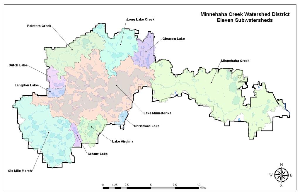
1 The Minnehaha Creek Watershed District s lake grading method was developed in The grade shows how your lake measures up compared to other area lakes. Grades are an indicator of the perceived condition of the open water. Three water quality parameters are combined to calculate each lake grade (see below). There are, of course, other factors that contribute to lake condition for example, aquatic plants, fisheries, harmful chemicals, over use, etc. Understanding Your Lake Grade The grades consider what is average or normal for lakes in a given area. What is a C in one part of the country might not be a C elsewhere. But, within the seven county metro area, grades can be compared. Grade Relative Ranking Description A 90% and up Crystal clear, beautiful. These lakes are exceptional and are enjoyed recreationally without question or hesitation. B 70 90% These lakes generally have good water quality but algae may limit swimming, particularly toward the end of summer. C 30 70% Average quality. Swimming, boating and fishing may be undesirable relatively early in the season. Algae blooms occasionally. D 10 30% These lakes have severe algae problems. People are generally not interested in recreation on these lakes. F Lowest 10% Not enjoyable. Such a lake would have several limitations to recreational use.
2 Factors in Your Lake Grade TP is total phosphorus. Increased phosphorus relates closely to increased algae, frequency of algae blooms and the increased quantity of blue green algae. CHL A is chlorophyll a or the green pigment in plants. Chlorophyll a is essential to photosynthesis. A measure of its presence in water estimates algae abundance. SD is the Secchi disk depth (water transparency). The deeper the Secchi disk is visible in the lake, the clearer the water appears. Improving Low Lake Grades Getting a better lake grade takes extra work. It might mean changes in drainage patterns, filtration or detention of storm water. Not all lakes have the same potential (shallow lakes can only so much water transparency). It s up to everyone to help water quality live up to its potential. Monitoring The District s waters are monitored on a regular basis. Data is collected by the MCWD, Three Rivers Park District, the Minneapolis Park & Recreation Board and Metropolitan Council Environmental Services. Those data are used to note and correct problems wherever possible. Data are summarized and studies are conducted to identify potential improvements. More Information Your yard and home might be a bad influence on your neighborhood lake. Keep your grades up prevent wastes (i.e., pet waste, lawn clippings, fertilizer or other chemical waste) from entering the water through the street storm drains. Storm drains are a direct, untreated route to the nearest lake or stream.
3
4 Lake Water Quality Grades, Lake Minnetonka Subwatershed Bay/Lake/Pond Black C+ C+ C+ B+ B- B B- C+ Carman B+ B+ B A- A A B+ A- Carsons A A- B+ B+ A A A A- A Cooks B B- B- B C+ B B B B- B- Crystal A- B+ B B- B- B+ B A B- A- Forest D C C- D D+ D+ D C C- C- French Lake Marsh N/A N/A Gideon A A- A Grays A A B+ B A B+ A- A A Halsted D+ C- C- D+ D D+ D D D D- Harrisons D+ C C- D D+ C- C- C D+ D+ Jennings D+ C- D D F D C- D D D- Lafayette B+ B+ B- A A A A- A Libbs B- B+ N/A N/A Lower Lake North B+ B+ B+ A A A A A Lower Lake South A A A- B+ B+ A A A A- A There was insufficient data to calculate a lake grade N/A A lake grade was not calculated because the Secchi disk was visible at the bottom of the lake and/or obstructed by vegetation during one or more monitoring events

5 Lake Water Quality Grades, Lake Minnetonka Subwatershed (continued) Bay/Lake/Pond Marion A A A Maxwell C+ B C+ C+ C B C+ B- B- C+ North Arm B- B B- B- C+ B B- B- B- C+ Peavey C C C D C- C+ C C C C- Phelps B+ B A- A- A B+ B+ Priests C- B- C+ C+ C+ C+ C+ C C- Shaver N/A N/A Smithtown B+ A- B B A B+ A B+ B+ Spring Park A A- B+ B B A- A- A A- A- St. Albans A A A B+ B A A A A- A Stubbs C- C C- D+ C- C C C C D+ Wayzata A A A- B+ B A A A A A West Arm D+ C C D+ D D+ C- C C- D West Upper B+ B A- B B- B+ B+ A B B- William --- C+* N/A* N/A* There was insufficient data to calculate a lake grade N/A A lake grade was not calculated because the Secchi disk was visible at the bottom of the lake and/or obstructed by vegetation during one or more monitoring events
6 Minnehaha Creek Subwatershed Brownie C+ C+ C+ C- C- Calhoun A A A A A- A A A A A Cedar B+ A- B+ B- B+ B B+ B B+ B+ Cobblecrest** F F F F F F F D --- Diamond C- D F F F D- D+ D N/A N/A Grass F C+ C C D+ D- Harriet A A A B+ A- B+ A A A A- Hiawatha C+ C+ B- C+ D+ C D+ C+ B- C- Isles C- C B- C C C C+ C C+ C Mother N/A N/A Nokomis C+ D+ C+ C- C- C C- C C+ C- Pamela Pond N/A N/A Powderhorn --- D+ C C- C C- C+ C D+ D+ South Oak** D D+ F F C D Twin** D F D- D F D- F D- F D- Westling Pond N/A F Windsor F D There was insufficient data to calculate a lake grade N/A A lake grade was not calculated because the Secchi disk was visible at the bottom of the lake and/or obstructed by vegetation during one or more monitoring events The lake was monitored by Minneapolis Parks and Recreation Board ** The lake was monitored by Metropolitan Council Environmental Services Citizen Assisted Monitoring Program
7 Christmas Lake Subwatershed Christmas A A- A A A A A A A A Dutch Lake Subwatershed Dutch D D C C C C C C C C- Schutz Lake Subwatershed Schutz C+ C- C C+ C+ C B- C C C- Gleason Lake Subwatershed Gleason D C- C- D D+ D+ C- C C C+
8 Lake Virginia Subwatershed Minnewashta A B+ A- B B+ A- B+ B+ B+ B+ Minnewashta (South Bay)** B+ A B- Virginia C --- C+ C C C- C C C C- St. Joe** A- A B A A- B+ A- A- A- Tamarack C** C** C** C** B** B** B** A-* B* B+* ** The lake was monitored by Metropolitan Council Environmental Services Citizen Assisted Monitoring Program Langdon Lake Subwatershed Langdon F F D F D- F D+ C- D+ F Saunders B+ N/A* B-* B-* Painter Creek Subwatershed Academy Marsh N/A F Katrina Lake F D+ F D The lake was monitored by Three Rivers Park District

9 Long Lake Creek Subwatershed Dickey's B B* B* B* Long C- C- C C- C- C C- C C- D+ Lydiard A A-* B+* A-* Mooney B- D C N/A* ---* Tanager D D- D D- D D D+ D D- Six Mile Marsh Subwatershed Carl Krey B B+ A- B Church B C B- C East Auburn B- C C C* C Kelser's Pond C+ C* C+* C+ Lundsten N C C+ B- --- N/A N/A Lundsten S F Marsh N/A N/A N/A Mud F F F F Parley D --- D+ D- D- D+ C- D+ D D+ Piersons A- --- B- B B+ B+ B A- A- A- Steiger C B- C+ C+ B B B- Stone C C+ B+ A- A- Turbid C+ C C- --- C C- Wassermann C- D+ D D+ D C- C- D C- D West Auburn B- B- B- A- B B+ B B+ B- A- Zumbra B B B- B B B+ A- A- A- A- The lake was monitored by Three Rivers Park District
Six Mile Halsted Bay Subwatershed Carp Management Implementation Plan
 Six Mile Halsted Bay Subwatershed Carp Management Implementation Plan May 18, 2017 Table of Contents Contents Executive Summary... 3 Overview of Carp in Six Mile Halsted Bay Subwatershed... 6 Management
Common Carp Assessment in Six Mile Creek Final Report: June 2014 December 2016
 Common Carp Assessment in Six Mile Creek Final Report: June 2014 December 2016 Prepared for the Minnehaha Creek Watershed District -- November 2016 Justine D. Dauphinais, Reid G. Swanson & Peter W. Sorensen
3.0 Basin and Watershed Characteristics
 3.0 Basin and Watershed Characteristics 3.1 Basin Characteristics 3.1.1 Crystal Lake Crystal Lake, located in the cities of Burnsville and Lakeville (Dakota County), covers an area of approximately 292
located Let s go fishing Hydrilla
 Our Lake of the Month for November is Lake August (set your GPS to 27.2750-81.4136). The elevation of Lake August is 102.5. Lake August is a 52 acre dredge hole lake (man-made from a former wetland; see
Shallow Lake Management Strategies. Steve McComas Blue Water Science Shallow Lakes Forum April 2014
 Shallow Lake Management Strategies Steve McComas Blue Water Science Shallow Lakes Forum April 2014 Shallow Lakes and Ponds Are Similar Shallow Lake Goal: Clear water and macrophytes. Clear Turbid Aquatic
Hypolimnetic Oxygenation for Indian Creek Reservoir Restoration. Bill Faisst CA/NV AWWA Fall Conference October 22, 2014
 Hypolimnetic Oxygenation for Indian Creek Reservoir Restoration Bill Faisst CA/NV AWWA Fall Conference October 22, 14 Indian Creek Reservoir High desert lake Little runoff ~ acre foot volume Regulatory
July 2018 METROPOLITAN COUNCIL S REGIONAL PARKS SYSTEM ANNUAL USE ESTIMATE: APPENDIX TABLES
 July 08 METROPOLITAN COUNCIL S REGIONAL PARKS SYSTEM ANNUAL USE ESTIMATE: APPENDIX TABLES The Council s mission is to foster efficient and economic growth for a prosperous metropolitan region Metropolitan
Zebra Mussel Action Plan
 Minneapolis Park and Recreation Board Zebra Mussel Action Plan Prepared By: MPRB Zebra Mussel Work Group December 2010 MPRB Aquatic Invasive Species Work Group Updated: 2018 1 Table of Contents Introduction...
Warm-up # 7 A day 5/17 - B day 5/18 UPDATE YOUR TABLE OF CONTENTS
 Warm-up # 7 A day 5/17 - B day 5/18 UPDATE YOUR TABLE OF CONTENTS Question: List all examples of surface water on Earth. Answer: Rivers and streams, lakes and reservoirs, (ponds) wetlands, estuaries and
MISSISSIPPI MAKEOVER A Plan for Restoration, Just Around the Bend
 MISSISSIPPI MAKEOVER A Plan for Restoration, Just Around the Bend Interim Report Card 2013 Project coordinated by the Dakota County Soil and Water Conservation District and sponsored by the Minnesota Pollution
Minnesota Designated Infested Waters Summary Compiled by Becker County COLA and Distributed by MN COLA - May 20, Know Before You Go!
 Minnesota Designated Infested s Summary Compiled by Becker COLA Distributed by MN COLA - May 20, 2012 MinnesotaCOLA@gmail.com Know Before You Go! Note: This information is a summary only was compiled from
Lake Minnetonka Conservation District 2016 Summer Rules Watercraft Operation and General Recreation
 Lake Minnetonka Conservation District 2016 Summer Rules Watercraft Operation and General Recreation Vern WhittenPhotography 125 Miles of Shoreline 14,043 Acres of Surface Use Area (42 Bays/Areas) 30 Foot
Minnesota s Managed Muskellunge Waters
 Minnesota s Managed Muskellunge Waters March 06 How many bodies of water does DNR manage for Muskellunge? The MNDNR manages about 4,85 lakes and rivers, or waters, (excluding Lake Superior) for fishing
Marine Ecosystems. Aquatic Ecosystems Section 2
 Marine Ecosystems Marine ecosystems are located mainly in coastal areas and in the open ocean. Organisms that live in coastal areas adapt to changes in water level and salinity. Organisms that live in
Understanding Today s Environmental Issues and the Oregon Stewardship Guidelines. David Phipps GCSAA NW Field Staff
 Understanding Today s Environmental Issues and the Oregon Stewardship Guidelines David Phipps GCSAA NW Field Staff My Roots Northwest Landscape Industries 1986-1990 The Oregon Golf Club 1990-2000 Stone
Overview of Recreational Pond Management
 Overview of Recreational Pond Management extension November 13 th 2013 Forrest Wynne State Extension Specialist for Aquaculture Kentucky State University Ponds are built for some of the following purposes:
RECREATIONAL PONDS AND LAKES
 RECREATIONAL PONDS AND LAKES POND ECOLOGY AQUATIC PLANTS & FISH F.S. Conte Department of Animal Science University of California Davis Photos By Flickr AQUATIC PLANTS POND HEALTH Chemical Recycling Oxygen
Better Fishing Means. Less Carping. At Bowman-Haley Reservoir. North Dakota Outdoors - June 1995 By Joe Bonneau, Dennis Scarnecchia, and Emil Berard
 Better Fishing Means Less Carping At Bowman-Haley Reservoir North Dakota Outdoors - June 1995 By Joe Bonneau, Dennis Scarnecchia, and Emil Berard Although the word origins of the fish called carp and the
STREAM SURVEY File form No..
 scanned for KRIS THE RESOURCES AGENCY OF CALIFORNIA California Department of Fish and Game STREAM SURVEY File form No.. Date: September 4, 1969. NAME: North Fork Schooner Gulch Creek COUNTY: Mendocino.
Keystone Lakes November 20, 2014
 FISH SURVEY REPORT Keystone Lakes November 20, 2014 Prepared for: Keystone HOA 6231 Shoreham Drive Evansville, IN 47711 Prepared by: Aquatic Control Inc. P.O. Box 100 Seymour, IN 47274 November 2015 -
Twin Cities Life-Jacket Wear-Rate Observational Study, 2007
 Twin Cities Life-Jacket Wear-Rate Observational Study, 2007 Minnesota Department of Natural Resources July 2008 Twin Cities Life-Jacket Wear-Rate Observational Study, 2007 Twin Cities Metro Lake Region
Ups and Downs in an Estuary
 Ups and Downs in an Estuary Whooping Crane Dilemma Modified from Texas Aquatic Science and Estuaries in the Balance Curriculum TEKS 6.2 E; 6.3 C; 6.12 E; 7.2 E; 7.3 C; 7.5 A; 7.8 A; 7.13 A; 8.2 E; 8.3
NURSERY POND Fish Management Report. Jason C. Doll Assistant Fisheries Biologist
 NURSERY POND 2004 Fish Management Report Jason C. Doll Assistant Fisheries Biologist FISHERIES SECTION INDIANA DEPARTMENT OF NATURAL RESOURCES DIVISION OF FISH AND WILDLIFE I.G.C. South, Room W273 402
Dry Hydrants. The installation of a non-pressurized pipe system into local water sources provides a ready means of supplying water to fire engines.
 Dry Hydrants What is a Dry Hydrant? A dry hydrant is a non-pressurized pipe system permanently installed in existing lakes, ponds and streams that provides a suction supply of water to a fire department
Estuary Manager. Estuary Manager. Estuary Manager. Estuary Manager
 You own a motorboat in the St. Louis River estuary. You think it is best to: Have fun on your boat. Sometimes this means breaking rules and going faster than the limits. People speed in their cars all
Indian River Lagoon: Lessons, Challenges and Opportunities
 Indian River Lagoon: Lessons, Challenges and Opportunities Upper Chain of Lakes Lake Kissimmee Kissimmee River Indian River Lagoon Caloosahatchee Estuary Lake Okeechobee St. Lucie Estuary Mark Perry, Executive
Figure 1: Map showing the relative location of the study sub-watersheds in Plymouth (south) and Maple Grove (north), MN.
 and Maple Grove (north), MN.") II. Grass clippings Methods Grass clippings from residential lawns have frequently been cited as a significant source of nutrients and organic matter transported to receiving waters from residential developments.
II. Grass clippings Methods Grass clippings from residential lawns have frequently been cited as a significant source of nutrients and organic matter transported to receiving waters from residential developments.
Quarry Lakes Fisheries Report EBRPD Fisheries Department. Joe Sullivan Fisheries Resource Analyst Peter Alexander Fisheries Program Manager
 Quarry Lakes Fisheries Report 2011 EBRPD Fisheries Department Joe Sullivan Fisheries Resource Analyst Peter Alexander Fisheries Program Manager Introduction The purpose of this report is to give lake supervisors
Mecklenburg County. Fish Consumption Advisories A Local Government Perspective
 Mecklenburg County Fish Consumption Advisories A Local Government Perspective David Caldwell Charlotte-Mecklenburg Storm Water Services Water Quality Program NCLMS October 4, 2012 Lake monitoring program
Community Open House December 13, A project of the Green Infrastructure Center, supported by Skeo Solutions
 Community Open House December 13, 2011 A project of the Green Infrastructure Center, supported by Skeo Solutions Project Background The Green Infrastructure Center, Inc. (GIC) was formed in 2006 to help
AQUATIC PLANT MANAGEMENT PLAN
 AQUATIC PLANT MANAGEMENT PLAN JENNI AND KYLE PRESERVE PONDS TENNEY PARK LAGOON VILAS PARK LAGOON WARNER PARK LAGOON Lower Rock River Basin and VERONA QUARRY Grant-Platte-Sugar-Pecatonica Basin DANE COUNTY,
Resources and Guidance for writing a River Herring Management Plan
 Resources and Guidance for writing a River Herring Management Plan In 2011 members of the River Herring Network brainstormed a list of questions that should be answered in order to develop a plan for herring
Aquatic Plant Management and Importance to Sport Fisheries
 Aquatic Plant Management and Importance to Sport Fisheries Presentation to Michigan Inland Lakes Convention May 2014 Mike Maceina Professor Emeritus School of Fisheries, Aquaculture, and Aquatic Sciences
The Rivers Of Minnesota: Recreation And Conservation By Thomas F. Waters
 The Rivers Of Minnesota: Recreation And Conservation By Thomas F. Waters If looking for a book by Thomas F. Waters The Rivers of Minnesota: Recreation and Conservation in pdf form, then you've come to
Lake information report
 Page 1 of 6 Lake information report Name: Saganaga Nearest Town: Grand Marais Primary County: Cook Survey Date: 08/08/2011 Inventory Number: 16063300 walleye stocking. Purchase a walleye stamp. Your voluntary
JadEco, LLC PO BOX 445 Shannon, IL 61078
 Introduction: With the assistance of Lake Holiday staff and volunteers, we were able to conduct an AC electrofishing survey on May 8, 27. Water temperatures were 2.3 C (8.5 F) and water clarity was decent
Tide Gate Modifications for Fish Passage and Water Quality Enhancement
 Tide Gate Modifications for Fish Passage and Water Quality Enhancement Tillamook Bay National Estuary Project 613 Commercial St. PO Box 493 Garibaldi, OR 97118 Phone (503) 322-2222 Fax (503) 322-2261 Jay
Midtown Corridor Alternatives Analysis
 Midtown Corridor Alternatives Analysis Ridership Forecast Methodology and Results December 2013 Prepared by the SRF Consulting Group Team for Table of Contents Introduction... 1 Methodology... 1 Assumptions...
Pine Lake News. Greetings from Pine Lake. Spring Pine Lake Commissioners. Chairperson: Greetings from the Board...
 Pine Lake Commissioners Chairperson: Terry Kloehn 811 Hillview Lane Hiles, WI 11 Commissioners: Jim Gehl 11 N. Range Line Court Mequon, WI 9 Paul Gagnon N77 W11 Woodview Drive Menomonee Falls, WI 1 Karl
2014 Island Lake Survey June 13 th, 2014 Andrew Plauck District Fisheries Biologist Report Prepared 4 March 2015
 2014 Island Lake Survey June 13 th, 2014 Andrew Plauck District Fisheries Biologist Report Prepared 4 March 2015 BACKGROUND - A fish survey was requested due to a moderately severe winterkill in Island
Sebec Lake Fisheries Management Plan 2012
 Sebec Lake Fisheries Management Plan 2012 Sebec Lake is a 6,800-acre oligotrophic lake located in northwestern Maine. It has popular fisheries for landlocked salmon, lake trout, and smallmouth bass. Other
The Salmon Circle of Life
 The Salmon Circle of Life for millions of years the wild salmon has helped nourish the plant and animal life of the temperate rain forest. Born in the streams and rivers of the forest, the salmon travels
WHO POLLUTED THE POTOMAC RIVER?
 WHO POLLUTED THE POTOMAC RIVER? [Walk over to the map and point to it while saying,] Let s take a look at a map of the state of Maryland. Way out in the western part of the state, we see a small body of
Guide to the UNDERC Stream Network
 Guide to the UNDERC Stream Network Tony Hollowell Bios 569 Practicum in Field Biology July 22, 23 Introduction While the UNDERC lakes have been described extensively and are well known, the UNDERC stream
SALINITY. It's the amount of dissolved salts the water contains.
 AQUATIC ECOSYSTEMS SALINITY The types of organisms in an aquatic ecosystem depend upon the water s Salinity. It's the amount of dissolved salts the water contains. Salinity determines the two main aquatic
City of Orono Lake Minnetonka Access Points - Designated Use and Cu
 City of Orono Lake Minnetonka Points - Designated Use and Cu ID Name Plat Section Between # or Street Name Address #s Brown s Bay (Lower Lake) 1a 1 End of Orono Lane 2-S 1355/1385 No public access Shoreline
COCOLALLA LAKE ASSOCIATION MEETING JUNE 17, 2008
 COCOLALLA LAKE ASSOCIATION MEETING JUNE 17, 2008 The annual membership and public meeting of the CLA was held on June 17, 2008, at the Cocolalla Community Hall. 14 members and guests were present. Board
Booklet translated by SREJ at CSDC 1
 Name: Gr. : Booklet translated by SREJ at CSDC 1 This is the beginning of a new project about Aquaculture. Before we start, I would like to see what you already know about the subject. Write all the words
SKIATOOK LAKE MANAGEMENT PLAN
 SKIATOOK LAKE MANAGEMENT PLAN Background Skiatook Lake impounds Hominy Creek, 5 miles west of Skiatook in Osage County, Oklahoma (Figure 1). Skiatook Lake covers 10,540 surface acres and was constructed
Are chloramines new? Why is my water supplier making the change to chloramines?
 In order to maintain quality water, the Central Coast Water Authority uses chloramines as disinfectant. Chloramines are a combination of chlorine and a small amount of ammonia. This web page provides answers
FACT SHEET MCGREGOR LAKE RESTORATION HABITAT PROJECT POOL 10, UPPER MISSISSIPPI RIVER, WISCONSIN ENVIRONMENTAL MANAGEMENT PROGRAM
 FACT SHEET MCGREGOR LAKE RESTORATION HABITAT PROJECT POOL 10, UPPER MISSISSIPPI RIVER, WISCONSIN ENVIRONMENTAL MANAGEMENT PROGRAM LOCATION McGregor Lake is located within a mid-river island in Pool 10
Willett Ave. Pond & Bullocks Cove Riverside, RI. Ed Serowik Pilgrim High School
 Willett Ave. Pond & Bullocks Cove Riverside, RI Ed Serowik Pilgrim High School A quote to begin Follow the river and you will find the sea French Proverb A Threatened Subwatershed Point and non-point
Tahquamenon River Assessment
 State owned land USFS land Superior Lower Falls USGS Gauging Station Superior Tahquamenon s Belle s Slater s Bass Betty B Dollarville Flooding Eckerman McMillan Mud East Kaks Twin McPhee s Hulbert Hulbert
BIG TWIN LAKE Kalkaska County (T28N, R05W, Section 18, and T28N, R06W, Section 13) Surveyed May 1999
 Surveyed May 1999") Michigan Department of Natural Resources Status of the Fishery Resource Report No. 2001-1, Year 2001 BIG TWIN LAKE Kalkaska County (T28N, R05W, Section 18, and T28N, R06W, Section 13) Surveyed May 1999
Michigan Department of Natural Resources Status of the Fishery Resource Report No. 2001-1, Year 2001 BIG TWIN LAKE Kalkaska County (T28N, R05W, Section 18, and T28N, R06W, Section 13) Surveyed May 1999
Chemical and Biological Recovery from Acidic Deposition in the Honnedaga Lake Watershed
 Chemical and Biological Recovery from Acidic Deposition in the Honnedaga Lake Watershed Abstract Honnedaga Lake supports one of seven remaining heritage strains of brook trout designated by the State of
From Phosphorus to Fish: Beneficial Use of Excess Nutrients
 FLOATINGISLANDINTERNATIONAL From Phosphorus to Fish: Beneficial Use of Excess Nutrients Project Location: Shepherd, Montana Fishing can be the primary method for transitioning excess nonpoint source nutrients
Chinook Salmon Spawning Study Russian River Fall 2005
 Chinook Salmon Spawning Study Russian River Fall 2005 Sonoma County Water Agency 2150 West College Avenue Santa Rosa, California 95401 Prepared by David Cook - Senior Environmental Specialist March 27,
Lake information report
 Lake information report: Minnesota DNR Page of 5 Lake information report jf Prinlable senior Name: Spring Nearest Town: Spring Lake (Scott) Primary County: Scott Survey Date: 08/02/200 Inventory Number:
2010 Fishing Opener Prognosis. Central Region
 2010 Fishing Opener Prognosis Central Region Hinckley PINE COUNTY Pokegama, Cross, Island, Oak and North and South Big Pine Lakes are typically the best lakes for targeting walleye in Pine County. They
CHAPTER 11.1 THE WORLD OCEAN MARINE BIOMES NOTES
 CHAPTER 11.1 THE WORLD OCEAN MARINE BIOMES NOTES 1. The world ocean can be divided into zones both and. The,, and zones that apply to large lakes also apply to the ocean. 2. In addition to the depth zones,
Redondo Pier Alternate Site Activity
 Name: Section: Redondo Pier Alternate Site Activity (Fisherman s Wharf, Redondo Beach, CA 90277) Lab 14C-1 The purpose of this activity is for you to participate in water sampling. We will examine ocean
MARTINDALE POND Wayne County 2004 Fish Management Report. Christopher C. Long Assistant Fisheries Biologist
 MARTINDALE POND Wayne County 2004 Fish Management Report Christopher C. Long Assistant Fisheries Biologist Fisheries Section Indiana Department of Natural Resources Division of Fish and Wildlife I.G.C.
Pool Water. Safe Water Practices for Pool & Spa Owners
 Pool Water Safe Water Practices for Pool & Spa Owners This brochure contains important information for safe and environmentally responsible management of pool and spa water Pool water and the environment
Nicholas Brown. 31 Bennett Rd Wolfeboro NH Application submitted
 Nicholas Brown 31 Bennett Rd Wolfeboro NH 03894 603-856-5454 Nick4634@gmail.com Application submitted 8-12-2017 Description of proposed project A. General Methodology The site located approximately 600
MIDDLE FORK RESERVOIR Wayne County 2004 Fish Management Report. Christopher C. Long Assistant Fisheries Biologist
 MIDDLE FORK RESERVOIR Wayne County 2004 Fish Management Report Christopher C. Long Assistant Fisheries Biologist FISHERIES SECTION INDIANA DEPARTMENT OF NATURAL RESOURCES DIVISION OF FISH AND WILDLIFE
STREAM Girls field notebook
 s STREAM Girls field notebook Welcome...... to your stream! Trout Unlimited is excited to offer you and other Girl Scouts the chance to really get to know your home waters. Over the next three days, you
BAY-SIC RATIOS. W. A.V.E. BAY-SIC Ratios
 BAY-SIC RATIOS INTRODUCTION: The land that surrounds the Chesapeake Bay spans 64,000 square miles and includes portions of six states Virginia, West Virginia, Maryland, Pennsylvania, Delaware, and New
CARL BLACKWELL LAKE MANAGEMENT PLAN
 CARL BLACKWELL LAKE MANAGEMENT PLAN Background Lake Carl Blackwell impounds Stillwater Creek, 10 miles west of Stillwater in Payne County, Oklahoma (Figure 1). The lake covers 3,370 surface acres and was
Healthy lakes add value to our communities. They provide a place to relax and recreate,
 Big Bass Lake Eastern Marathon County Lake Study Final Study Results 2013 University of Wisconsin-Stevens Point and Marathon County Staff and Citizens Healthy lakes add value to our communities. They provide
Columbia Lake Dam Removal Project
 Columbia Lake Dam Removal Project The Columbia Lake dam located 1/4 mile upstream of the Paulins Kill River's confluence with the Delaware River in Knowlton Township, Warren County has been proposed for
Lake Minnetonka Conservation District Newsletter
 SM Vol. 7, Issue 2 Fall/Winter 2012 Lake Minnetonka Conservation District Newsletter Message from Chair Doug Babcock: While hawking a local estate sale, I ran across and purchased a map of Lake Minnetonka
First-Year Growth and Survival of Largemouth Bass Fingerlings Stocked into Western South Dakota Ponds
 507-F First-Year Growth and Survival of Largemouth Bass Fingerlings Stocked into Western South Dakota Ponds Nicholas R. Peterson, Justin A. VanDeHey, and David W. Willis Department of Wildlife and Fisheries
Crooked Lake Oakland County (T4N, R9E, Sections 3, 4, 9) Surveyed May James T. Francis
 Surveyed May James T. Francis") Michigan Department of Natural Resources Status of the Fishery Resource Report No. 2004-1, 2004 Crooked Lake Oakland County (T4N, R9E, Sections 3, 4, 9) Surveyed May 2002 James T. Francis Environment Crooked
Michigan Department of Natural Resources Status of the Fishery Resource Report No. 2004-1, 2004 Crooked Lake Oakland County (T4N, R9E, Sections 3, 4, 9) Surveyed May 2002 James T. Francis Environment Crooked
Why do different beaches have different types of vegetation?
 Why do different beaches have different types of vegetation? Allan Crowe Environment Canada National Water Research Institute Burlington, Ontario Environment Canada Environnement Canada NATIONAL WATER
Rule 1-4: Points Not Covered by Rules. Rule 14-3: Artificial Devices, Unusual Equipment and Unusual Use of Equipment. Rule 18: Ball at Rest Moves
 Ocean Ridge Men s Golf Association Local Rules (Revised August 5, 2018) In accordance with the ORMGA by-laws, members of the ORMGA must adhere to the USGA Rules of Golf, and by these ORMGA local rules,
IZAAK WALTON LEAGUE OF AMERICA. Strategic Plan
 IZAAK WALTON LEAGUE OF AMERICA Strategic Plan 2014-2019 At the turn of the 20th century, uncontrolled discharges of industrial waste and raw sewage, unrestricted logging, and soil erosion threatened to
Examples of estuaries include bays, sounds, salt marshes, mangrove forests, mud flats, swamps, inlets, and sloughs.
 An estuary is a partially enclosed body of water where incoming seawater is mixed with fresh water coming from the land. Examples of estuaries include bays, sounds, salt marshes, mangrove forests, mud
KICKAPOO LAKE Shakamak State Park Sullivan, Greene, and Clay Counties 2009 Fish Management Report. David S. Kittaka Fisheries Biologist
 KICKAPOO LAKE Shakamak State Park Sullivan, Greene, and Clay Counties 2009 Fish Management Report David S. Kittaka Fisheries Biologist Fisheries Section Indiana Department of Natural Resources Division
Lamprey River. Junior Ranger Study Guide and Activity Book
 Lamprey River Junior Ranger Study Guide and Activity Book Junior Ranger Lamprey River A Family-Centered Way to Learn about and Help Protect your River Created by the Lamprey Rivers Advisory Committee Copyright
Notebooks or journals for drawing and taking notes
 Title: Have to Have a Habitat Grade Level: 5 th -8 th grade Topic: Trout Habitat Background: The following chart lists the ideal conditions for trout habitat. Dissolved Oxygen: > 7 mg/l ph: 5.5-7 Next
2011 SUMMARY REPORT Juvenile Steelhead Densities in the San Lorenzo, Soquel, Aptos and Corralitos Watersheds, Santa Cruz County, CA
 211 SUMMARY REPORT Juvenile Steelhead Densities in the San Lorenzo, Soquel, Aptos and Corralitos Watersheds, Santa Cruz County, CA, Aquatic Biology Don Alley, Jerry Smith and Chad Steiner, Fishery Biologists
Reflections: Standley Lake by Kelly Cline, October, 2008
 Reflections: Standley Lake by Kelly Cline, October, 2008 How It All Began The Standley Lake story began as Blue Bird Jones Lake, which was owned by Joseph Standley. This lake was below Kinnear Lake on
Refined Designated Uses for the Chesapeake Bay and Tidal Tributaries
 A-1 appendixa Refined Designated Uses for the Chesapeake Bay and Tidal Tributaries BACKGROUND Federal water quality standards regulations establish that states must specify appropriate water uses to be
LAKE LU Fishing Newsletter
 LAKE LU Fishing Newsletter January March May July September November Inches of Rainfall Three Year Rainfall Comparison 8 7 6 5 4 3 2 1 2017 Monthly Rainfall 2016 Monthly Rainfall 2015 Monthly Rainfall
Ebert Lake 8 Lime Lake - 13
 8 - Number of responses Number of Responses Amount of Aquatic Plant Growth..5..5. Amount of aquatic plant growth.5 7. very_little right_amount dense_growth not_sure no_response 6 5 Dense_growth Choked_growth
NIANGUA SNAPSHOT ISSUE Nutrients 2 Suspended Sediment 3 Salinity 4 Summary 5
 Niangua River Watershed Snapshot Volume 14 Number 2 The 125-mile long Niangua River meanders northward from the town of Marshfield on I-44 to the Lake of the Ozarks. Its watershed covers more than 658,000
Boat launches through public accesses on Lake Minnetonka from mid-april to mid-november, 2010
 Boat launches through public accesses on Lake Minnetonka from mid-april to mid-november, 2010 This study was a cooperative effort of the Lake Minnetonka Conservation District and the Minnesota Department
Illinois Lake Management Association Conference March 23, 2018 By Trent Thomas Illinois Department of Natural Resources Division of Fisheries
 Illinois Lake Management Association Conference March 23, 2018 By Trent Thomas Illinois Department of Natural Resources Division of Fisheries Sources of Habitat Impairment Sedimentation Channelization
Proposed Reclassification of Muskrat Creek, North Platte River Basin in Goshen County, Wyoming
 Proposed Reclassification of Muskrat Creek, North Platte River Basin in Goshen County, Wyoming October 25, 2010 Waterbody: Muskrat Creek - Mainstem of Muskrat Creek from its headwaters downstream to its
2015 Annual Report. February 15, 2016
 2015 Annual Report February 15, 2016 2015 Round Lake Management Commission (RLMC) Annual Report Contents The Round Lake Mgt Commission 2015 Year in Review Huebner Fishery Mgt Foundation Shoreline Restoration
HOW TO CHOOSE YOUR POOL WATER COLOR
 HOW TO CHOOSE YOUR POOL WATER COLOR For some choosing a water color can be an agonizing decision. You ve probably made a hundred decisions already when it comes to the construction of your swimming pool.
To help protect Becker County s lakes and rivers, please keep these points in mind before transporting watercraft.
 BECKER COUNTY FORESTRY TOURISM INDUSTRY Established to Serve Since 1858 Becker County AGRICULTURE Minnesota is known for its clean water, good fishing, and incredible recreational opportunities. With your
For Creative Minds. Salt Marsh Plants and Animals
 For Creative Minds The For Creative Minds educational section may be photocopied or printed from our website by the owner of this book for educational, non-commercial uses. Cross-curricular teaching activities,
An Important Change to Pinery s Water in March
 An Important Change to Pinery s Water in March Chloramine Conversion Project The Pinery Water District is scheduled to convert its water disinfection process to a chloramine treatment process March 2018.
The Amston Laker. PHOSPHOROUS and YOU. By: Mark Paul - ALD President
 1 The Amston Laker Spring 2016 District News The Amston Laker Spring 2016 www.amstonlake.org PHOSPHOROUS and YOU By: Mark Paul - ALD President Reduce and control your phosphorous contribution to the Amston
Pre-field Trip Activities. What do scientists study at SERC? Unscramble the words to list some of the topics studied.
 Pre-field Trip Activities What do scientists study at SERC? Unscramble the words to list some of the topics studied. RATEW SIFH IAR SLDTEWAN STAPLN RETEPONACY EGALA SIVEN THEREWA BRACS TROSSEF Take the
Name of Applicant Phone Number # Mailing Address. City State Zip
 VIRGINIA DEPARTMENT OF GAME AND INLAND FISHERIES EXOTIC SPECIES APPLICATION/PERMIT TO IMPORT CERTIFIED TRIPLOID GRASS CARP FOR AQUATIC VEGETATION CONTROL IN PRIVATE PONDS (Under Authority of 4 VAC 15-30-40
Quassaick Creek. Watershed Management Plan. Advisory Committee Meeting #3 July 20 th, 2012
 Quassaick Creek Watershed Management Plan Advisory Committee Meeting #3 July 20 th, 2012 Assessment Report Subwatershed Delineation Characterizes watershed based on Hydrology/Topography (primary) Land
TABLE ROCK LAKE 2014 ANNUAL LAKE REPORT. Shane Bush Fisheries Management Biologist Missouri Department of Conservation Southwest Region
 TABLE ROCK LAKE 14 ANNUAL LAKE REPORT Shane Bush Fisheries Management Biologist Missouri Department of Conservation Southwest Region March 1, 15 EXECUTIVE SUMMARY Table Rock Lake is a 43,1 acre reservoir
EXTENT OF OBSERVATION
 scanned for KRIS THE RESOURCES AGENCY OF CALIFORNIA Department of Fish and Game STREAM SURVEY Date: May 25 and 31, 1977. NAME: Unnamed Stream (Tributary to Sonoma Creek) COUNTY: Sonoma. STREAM SECTION: