Dare County Nourishment Project Town of Duck
|
|
|
- Merryl Goodman
- 5 years ago
- Views:
Transcription


1 Dare County Nourishment Project Town of Duck Julien Devisse, P.E. and Ken Willson CB&I / Coastal Planning & Engineering of North Carolina, Inc. February 15, 2017 A World of Solutions
2 Outline Background Beach Fill Design/Construction Plans Borrow Area Design/Construction Plans Construction Photos Bid Items and Schedule Monitoring/Renourishment Questions A World of Solutions 1

3 Background Southern Shores Project Limits ~1.6 Miles 1.4 MCY 1,500 feet 80,000 CY ~3.6 Miles 1.8 MCY ~2.6 Miles 0.9 MCY Approx. 8.3 miles and 4.1 MCY A World of Solutions 2
4 Storm Damage Reduction Project Pre-Project Conditions 3
5 Storm Damage Reduction Project Constructed Beach Fill Initial Construction 4
6 Storm Damage Reduction Project Post-Construction Adjustment in 6-18 months Equilibration of Beach Fill 5
7 Storm Damage Reduction Project Advance Fill Design Beach Nourishment Interval 6
8 Storm Damage Reduction Project Design Beach Loss of Advance Fill During Project Interval Nourishment Interval 7
9 Storm Damage Reduction Project Maintenance (Renourishment) Maintenance = Beach Renourishment 8
10 Profile Equilibration Construction Template Pre-Construction Beach Profile A World of Solutions 9

11 Profile Equilibration Constructed Fill A World of Solutions 10
12 Profile Equilibration Profile Equilibration between January 2015 and July 2015 Profile Equilibration Equilibrated Fill A World of Solutions 11


13 Wave Height Reduction Profile Equilibration between January 2015 and July 2015 Reduction in depth = Reduction in wave height A World of Solutions 12

14 Wave Height Reduction ~1.6 Miles 1.1 MCY 2,500 feet 80,000 CY ~2.7 Miles 0.9 MCY Courtesy of ASBPA A World of Solutions 13
15 Outline Background Beach Fill Design/Construction Plans Borrow Area Design/Construction Plans Construction Photos Bid Items and Schedule Monitoring/Renourishment Questions A World of Solutions 14
16 Project Design Duck Design Classic Advanced Fill and Design Cross Section Concept Design Cross Section Based on Storm Induced Beach Change Model (SBEACH) Advanced Fill Based on 5 Year Renourishment Interval A World of Solutions 15
17 Storm Induced Beach Change Model (SBEACH) Simulates beach profile changes that result from varying storm waves and water levels Identify structures potentially impacted during storm events Additional surveys and SBEACH analysis conducted Town wide A World of Solutions 16
")

18 Storm Induced Beach Change Model (SBEACH) Eliminated Impacts With 20/80 Design A World of Solutions 17
19 Design ft. Dune Town of Duck Design +20 ft. NAVD Elevation (FT NAVD) ft. Average Design Berm +6 ft. NAVD 5 10 Existing Profile Distance Along Profile (FT) A World of Solutions 18
20 Cover Sheet A World of Solutions 19


21 Control Data A World of Solutions 20

22 Plan View Staging Area Spindrift Lane Bufflehead Road Skimmer Way A World of Solutions 21

23 Staging Area A World of Solutions 22
 Seaward Berm Crest (4)Toe of Fill (1) Dune (2) Berm (3) (4) A World of Solutions")
24 Plan View Baseline Spindrift Lane (1) Dune Bufflehead Road (2) Landward Berm Crest (3) Seaward Berm Crest (4)Toe of Fill (1) Dune (2) Berm (3) (4) A World of Solutions 23

25 Plan View Bufflehead Road A World of Solutions 24

26 Plan View Skimmer Way A World of Solutions 25
27 Cross Sections A World of Solutions 26
28 Construction Template ft. Dune Town of Duck Construction Profile +20 ft. NAVD Elevation (FT NAVD) ft. Average Construction Berm +6 ft. NAVD 5 10 Template Existing Profile Distance Along Profile (FT) A World of Solutions 27
29 Construction Template Town of Duck Construction Profile Elevation (FT NAVD) / 0.5 ft. Paid Tolerance 5 10 Template Existing Profile Distance Along Profile (FT) A World of Solutions 28
30 Construction Template Town of Duck Construction Profile No Pay Elevation (FT NAVD) Eligible for Payment +/ 0.5 ft. Paid Tolerance 10 Template Existing Profile Distance Along Profile (FT) A World of Solutions 29
31 Outline Background Beach Fill Design/Construction Plans Borrow Area Design/Construction Plans Construction Photos Bid Items and Schedule Monitoring/Renourishment Questions A World of Solutions 30

32 Borrow Areas A World of Solutions 31

33 Borrow Area Design Locations of geophysical tracklines surveyed and vibracores collected during Phase II and III. A World of Solutions 32


34 Vibracore Analysis Vibracore Analysis Grain Size, Sorting, Silt %, Munsell Color, Shell Hash, Carbonate % A World of Solutions 33

35 Borrow Area Design Proposed Borrow Area C Proposed Design Area = 354 Acres Proposed Design Volume = 2,049,000 cy A World of Solutions 34
36 Borrow Area Plan View A World of Solutions 35
37 Borrow Area Cross Sections A World of Solutions 36
38 Town of Duck Borrow Area Design Borrow Area C finer grained material than native Option 1 - If entire Town of Duck Project constructed from Borrow Area C - 20% Volume Increase Option 2 2:1 ratio (borrow area A: borrow area C) A World of Solutions 37


39 Grain Sizes Coarser Finer Sand Designed Beach A World of Solutions 38
40 Outline Background Beach Fill Design/Construction Plans Borrow Area Design/Construction Plans Construction Photos Bid Items and Schedule Monitoring/Renourishment Questions A World of Solutions 39


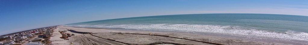
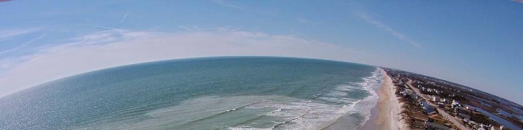
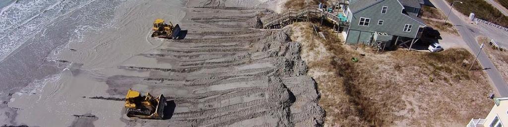
41 Construction Photos Fill Area Overview A World of Solutions 40


42 Construction Photos Fill Area Overview A World of Solutions 41
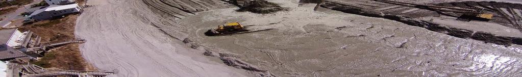

43 Construction Photos Work Limits A World of Solutions 42


44 Construction Photos Work Limits A World of Solutions 43


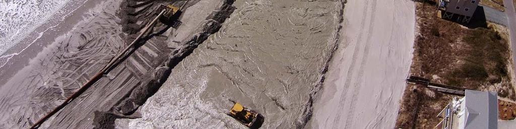
45 Construction Photos Dune Construction A World of Solutions 44


46 Construction Photos Work Area A World of Solutions 45


47 Construction Photos No Hold Harmless A World of Solutions 46

48 Construction Photos Hold Harmless In Place A World of Solutions 47

49 Construction Photos Sand Ramp A World of Solutions 48


50 Construction Photos Sand Ramps A World of Solutions 49


51 Construction Photos Lighting Shields Condition as of August 7, 2014 (looking south)

52 Construction Photos Lighting Shields Condition as of August 7, 2014 (looking south)
53 Outline Background Beach Fill Design/Construction Plans Borrow Area Design/Construction Plans Construction Photos Bid Items and Schedule Monitoring/Renourishment Questions A World of Solutions 52
54 Bid Items Base Bid Items 3 Towns Mob/Demob, Bonds, BA surveys and Turtle Trawling (5 days) Beach Fill Discretionary Bid Items Potential Unsuitable Fill Material Screening/Removal Environmental Protection Additional Trawling Tilling Turbidity Monitoring Dredge Standy Rates Owner or Regulatory Agency shuts down work (not weather/mechanical delays) A World of Solutions 53


55 Sea Turtle Monitoring Network for Endangered Sea Turtles (N.E.S.T.) May 1 through Nov 15 Nesting Surveys between sunrise and 9 am must clear beach Limits of beach fill reduced Nighttime turtle observer on-site/escort outside of active work zone Sea Turtle observed Work stopped within 500 ft. Lays nest Work shall not resume within 500 ft. until relocated Courtesy of N.E.S.T A World of Solutions 54
56 TENTATIVE Schedule The Schedule is not binding and is meant to provide estimated construction times for planning purposes. The beach nourishment start and end dates are subject to change. Information will be updated as new information becomes available. ~1.6 Miles 1.4 MCY Duck Start Mid/late May End Mid/late July (~60 days) 1,500 feet 80,000 CY KH/Southern Shores Start Mid June End - Mid August (~60 days) ~3.6 Miles 1.8 MCY Kill Devil Hills Start Early August End Early/Mid Sept (~35-45 days) ~2.6 Miles 0.9 MCY Approx. 8.3 miles and 4.1 MCY A World of Solutions 55
57 Moving Forward Construction Town Wide Monitoring Analysis of Town Wide Conditions Nourishment / Renourishment A World of Solutions 56

58 Thank you! Contact Julien Devisse, P.E. Project Engineer (910) Office A World of Solutions 57
59 Frequently Asked Questions Why does the sand pumped onto the beach initially appear to be a darker color? What impacts can be expected during nourishment construction? What if the contracted volume is reached before all sections of the project area receive sand? What will happen to the organisms, such as sand fleas, that live on the beach and in the surf zone? Why are there escarpments on the beach? Why don t we have federal assistance like Wrightsville Beach or Virginia Beach? What do you mean by FEMAreimbursed nourishment? What happens if a storm hits and damages the beach? How long will construction take place in front of a particular property? Why is dredging occurring during the summer months?
60 Frequently Asked Questions Why does the sand pumped onto the beach initially appear to be a darker color? The sand has been buried and unexposed to sunlight. Once exposed to the elements, this disappears quickly and the material will match the existing sand. What impacts can be expected during nourishment construction? Once the project starts the contractor will be working 24/7 to complete the project as quickly as possible. To ensure public safety during this time, direct access to the beach in front of a given property will be prohibited. The contractor will install caution tape at crossovers that lead to the active construction area. Likewise, the contractor will install a temporary barrier on the northern and southern boundary of the active construction area to prohibit pedestrian traffic. In the immediate construction zone, the sound of heavy equipment, including backup alarms, will be heard and, at night, lights will be visible. As the project moves down the beach, a pipe will be placed incrementally to pump the sand for the project. Ramps will be provided at regular intervals to ensure that access to the water is maintained.
61 Frequently Asked Questions What if the contracted volume is reached before all sections of the project area receive sand? GLDD and CPE-NC will monitor the quantity placed each day to insure that the nourishment volume is distributed according to plan. Minor adjustments are made as the project progresses along the beach in response to changing conditions so as to provide the planned nourishment volume within each subsection of the project area. What will happen to the organisms, such as sand fleas, that live on the beach and in the surf zone? Benthic organisms (organisms that live on or near the seabed) in the surf zone generally have short life cycles and recover rapidly after beach nourishment (or severe storms). Typical recovery rates are measured in months according to numerous studies. Why are there escarpments on the beach? Equilibration of the profile may leave low escarpments at the edge of the surf between the new dry beach and the wet beach. This process is similar to what natural beaches experience after minor storm events, particularly during the first northeasters of the fall. Any escarpments greater than 18 inches that are present between May 1 and August 30 shall be leveled.
62 Frequently Asked Questions Why don t we have federal assistance like Wrightsville Beach or Virginia Beach? Unfortunately, federal funds for beach nourishment have never been made available to Nags Head. Dare County has been working with the US Army Corps of Engineers on a county-wide, federally-funded project for many years, but money for construction has never been allocated. What do you mean by FEMA-reimbursed nourishment? If the Town experiences a storm that is declared a disaster by the President, the Town may be eligible for FEMA funding to replace sand lost during that storm. A monitoring and maintenance plan, along with a plan for funding the maintenance, must be in place for FEMA to consider reimbursing the Town for lost sand. What happens if a storm hits and damages the beach? The Town will establish a monitoring and maintenance program that will help us determine the amount of sand loss so that we can move forward with either the regular maintenance nourishment or a FEMAreimbursed nourishment.
63 Frequently Asked Questions How long will construction take place in front of a particular property? The progress can vary greatly depending weather, downtime and the volume of sand being placed along the beach. At the commencement of the project, progress is typically slower as the contractor needs some time to work out the kinks in their equipment. Once these kinks have been worked out, the contractor averages between 150 and 250 feet of beach per day. Therefore, a specific property will be impacted by construction on average 4 to 6 days. Once the Project commences a daily progress map will be available at Why is dredging occurring during the summer months? Dredging operations offshore of the Outer Banks typically take place in the summer months because it is much safer for the crews working on the offshore dredge. The increased risk of safety and anticipated decreases in productivity in the winter months when sea conditions can shut down dredge operations were found to drive the costs of the projects up to a point where they would have no longer been financially viable.

64 Summertime Dredging A World of Solutions 63
ATLANTIC COAST OF LONG ISLAND, JONES INLET TO EAST ROCKAWAY INLET, LONG BEACH ISLAND, NY. Contract #2 Construction Scope. April 18th-19th 2018
 ATLANTIC COAST OF LONG ISLAND, JONES INLET TO EAST ROCKAWAY INLET, LONG BEACH ISLAND, NY Contract #2 Construction Scope April 18th-19th 2018 New York District PLAN COMPONENTS Length of Beachfill 35,000
Town of Duck, North Carolina
 Tracking No. 00.00.2010 Erosion Mitigation And Shoreline Management Feasibility Study Town of Duck, North Carolina Coastal Planning & Engineering of North Carolina February 28, 2013 Ken Willson 1 Tracking
UPPER BEACH REPLENISHMENT PROJECT RELATED
 ASSESSMENT OF SAND VOLUME LOSS at the TOWNSHIP of UPPER BEACH REPLENISHMENT PROJECT RELATED to the LANDFALL OF HURRICANE SANDY - PURSUANT TO NJ-DR 4086 This assessment is in response to Hurricane Sandy
Atlantic Coast of Long Island, Jones Inlet to East Rockaway Inlet, Long Beach Island, NY Construction Update
 Atlantic Coast of Long Island, Jones Inlet to East Rockaway Inlet, Long Beach Island, NY Construction Update June 2016 US Army Corps of Engineers Project Purpose Three specific damage mechanisms of coastal
RE: Hurricane Matthew Beach Damage Assessment and Recommendations [CSE 2416]
![RE: Hurricane Matthew Beach Damage Assessment and Recommendations [CSE 2416]](/thumbs/83/87675702.jpg "RE: Hurricane Matthew Beach Damage Assessment and Recommendations [CSE 2416]") October 25, 2016 Iris Hill Town Administrator Town of Edisto Beach 2414 Murray St Edisto Beach SC 29438 RE: Hurricane Matthew Beach Damage Assessment and Recommendations [CSE 2416] Dear Iris, Hurricane
October 25, 2016 Iris Hill Town Administrator Town of Edisto Beach 2414 Murray St Edisto Beach SC 29438 RE: Hurricane Matthew Beach Damage Assessment and Recommendations [CSE 2416] Dear Iris, Hurricane
Building Beaches with Navigation Sand, Just Don t Forget the Dunes!!
 Building Beaches with Navigation Sand, Just Don t Forget the Dunes!! Ken Willson Kenneth.Willson@CBI.com Introduction Decrease in Federal Funding (Shallow Draft Navigation Maintenance and Shore Protection)
Navarre Beach & Dune Restoration Project Status Report to be regularly updated June 17, 2016 Report
 Navarre Beach & Dune Restoration Project Status Report to be regularly updated June 17, 2016 Report Work Completed (June 11 to June 17) Weeks Marine Inc. (Contractor): o continued filling Segment 4 including
Town of Duck, North Carolina
 Tracking No. 00.00.2010 Erosion Mitigation And Shoreline Management Feasibility Study Town of Duck, North Carolina Coastal Planning & Engineering of North Carolina August 15, 2012 Tom Jarrett Robert Neal
2018 Beach Preservation Project Information
 QUICK FACTS Beach Renourishment to begin late April 2018 o U.S. Army Corps of Engineers project o Project Area: 8 th St. E. to end of E. Ashley Ave. o Project Length: 2 miles o Cost: $10,900,000 o Funding:
Beach Nourishment Impact on Beach Safety and Surfing in the North Reach of Brevard County, Florida
 Beach Nourishment Impact on Beach Safety and Surfing in the North Reach of Brevard County, Florida Prepared by John Hearin, Ph.D. Coastal Engineering Vice Chairman Cocoa Beach Chapter Port Canaveral Patrick
North Shore of Long Island, Feasibility Study
 North Shore of Long Island, Asharoken New York Asharoken, Feasibility Study Asharoken, NY Public Meeting June 30, 2015 US Army Corps of Engineers US Army Corps of Engineers New York BUILDING STRONG BUILDING
PLAQUEMINES PARISH BARRIER ISLAND RESTORATION & SUSTAINABILITY. MVD/Gulf Coast Regional Dredging Meeting November 5, 2013
 PLAQUEMINES PARISH BARRIER ISLAND RESTORATION & SUSTAINABILITY MVD/Gulf Coast Regional Dredging Meeting November 5, 2013 OVERVIEW 1. Barrier Island Restoration Projects in Plaquemines Parish 2. Plaquemines
The 2017 Panama City Beaches Beach Interim Renourishment Project. Answers to Common Questions
 The 2017 Panama City Beaches Beach Interim Renourishment Project The fourth renourishment of the Panama City Beaches will be under construction during March and April 2017, with a planned completion by
HURRICANE SANDY LIMITED REEVALUATION REPORT UNION BEACH, NEW JERSEY DRAFT ENGINEERING APPENDIX SUB APPENDIX D SBEACH MODELING
 HURRICANE SANDY LIMITED REEVALUATION REPORT UNION BEACH, NEW JERSEY DRAFT ENGINEERING APPENDIX SUB APPENDIX D SBEACH MODELING Rev. 18 Feb 2015 1 SBEACH Modeling 1.0 Introduction Following the methodology
Figure79. Location map for the 10 NJBPN profile sites in Atlantic County, NJ 155
 154 Figure79. Location map for the 10 NJBPN profile sites in Atlantic County, NJ 155 ATLANTIC COUNTY SPRING 2009 to FALL 2010 The Atlantic County coastline consists of three barrier islands. Between Little
Dauphin Island East End Beach and Barrier Island Restoration Project. Beau Buhring South Coast Engineers
 Dauphin Island East End Beach and Barrier Island Restoration Project Beau Buhring South Coast Engineers Funding Funded with qualified outer continental shelf oil and gas revenues by the Coastal Impact
Feasibility Report and Environmental Impact Statement. Coastal Storm Damage Reduction SURF CITY AND NORTH TOPSAIL BEACH, NORTH CAROLINA.
 Feasibility Report and Environmental Impact Statement on Coastal Storm Damage Reduction SURF CITY AND NORTH TOPSAIL BEACH, NORTH CAROLINA Appendix H Correspondence Appendix H Correspondence This appendix
ST. LUCIE COUNTY, FLORIDA
 ST. LUCIE COUNTY, FLORIDA COASTAL STORM RISK MANAGEMENT STUDY Draft Feasibility Study & Integrated Environmental Assessment Public Meeting Presented by U.S. Army Corps of Engineers Jacksonville District
Changes in Beach Profile and Grain Size after Beach Renourishment
 Kevin Bodge, PE PhD Krista Egan, EI olsen associates, inc. and Mike McGarry Brevard County Natural Resources Mgt. Dept. Changes in Beach Profile and Grain Size after Beach Renourishment February 2018 Beach
Delaware Chapter Surfrider Foundation - Indian River Inlet Monitoring
 Delaware Chapter Surfrider Foundation - Indian River Inlet Monitoring In 2012, the Delaware Surfrider Foundation Chapter formed the Surf Quality and Access Committee to focus on issues such as surf spot
2014 ANNUAL REPORT - TO THE CITY OF NORTH WILDWOOD ON THE CONDITION OF THE CITY BEACHES
 2014 ANNUAL REPORT - TO THE CITY OF NORTH WILDWOOD ON THE CONDITION OF THE CITY BEACHES View on September 25, 2014 looking northwest into Hereford Inlet. Considerable southerly expansion of the tip of
2013 ANNUAL REPORT - TO THE CITY OF NORTH WILDWOOD ON THE CONDITION OF THE CITY BEACHES
 2013 ANNUAL REPORT - TO THE CITY OF NORTH WILDWOOD ON THE CONDITION OF THE CITY BEACHES View on June 18, 2013 from the 2 nd Avenue jetty looking south while the 2013 beach nourishment project was under
CROSS-SHORE SEDIMENT PROCESSES
 The University of the West Indies Organization of American States PROFESSIONAL DEVELOPMENT PROGRAMME: COASTAL INFRASTRUCTURE DESIGN, CONSTRUCTION AND MAINTENANCE A COURSE IN COASTAL DEFENSE SYSTEMS I CHAPTER
BEACH FILL CONSTRUCTION USING SEABED REHANDLING AREAS. Kevin R. Bodge, Ph.D., P.E. 1
 Proceedings, 28 th International Conference on Coastal Engineering. 2002. World Scientific Publishing Co. Pte. Ltd. Volume 3 - ISBN 981-238-984-9. pp. 3736-3747 BEACH FILL CONSTRUCTION USING SEABED REHANDLING
Virginia Beach, Virginia Beach Re-Nourishment Projects: Sandbridge Beach and Resort Beach
 Virginia Beach, Virginia Beach Re-Nourishment Projects: Sandbridge Beach and Resort Beach Norfolk District City of Virginia Beach US Army Corps of Engineers Jim White Kristin.M.Mazur@usace.army.mil jawhite@vb.gov
Figure 262. Location map for the 10 NJBPN profile sites in Atlantic County, NJ 279
 278 Figure 262. Location map for the 10 NJBPN profile sites in Atlantic County, NJ 279 ATLANTIC COUNTY SUMMARY The Atlantic County coastline consists of three barrier islands. The island of Little Beach
Chapter 11. Beach Fill and Soft Engineering Structures
 Chapter 11 Beach Fill and Soft Engineering Structures Solutions to Coastal Erosion Soft Structures Hard Structures Retreat No such thing as low cost coastal protection Beach Nourishment Beach Filling Beach
Long Term Success and Future Approach of the Captiva and Sanibel Islands Beach Renourishment Program
 2017 National Conference on Beach Preservation Technology February 8-10, 2017; Stuart, Florida Long Term Success and Future Approach of the Captiva and Sanibel Islands Beach Renourishment Program Thomas
2015 ANNUAL REPORT - TO THE CITY OF NORTH WILDWOOD ON THE CONDITION OF THE CITY BEACHES
 2015 ANNUAL REPORT - TO THE CITY OF NORTH WILDWOOD ON THE CONDITION OF THE CITY BEACHES Ariel view of North Wildwood looking south from the Hereford Inlet perspective on June 24, 2015. The main channel
FINDING OF NO SIGNIFICANT IMPACT
 DEPARTMENT OF THE ARMY CHARLESTON DISTRICT, CORPS OF ENGINEERS 69A HAGOOD AVENUE CHARLESTON, SOUTH CAROLINA 29403-5107 FINDING OF NO SIGNIFICANT IMPACT EDISTO BEACH COASTAL STORM DAMAGE REDUCTION GENERAL
Effectiveness of Beach Nourishment in Response to Sea Level Rise
 2014 FSBPA Annual Conference Effectiveness of Beach Nourishment in Response to Sea Level Rise Navarre Beach Santa Rosa County July 18, 2005 Lovers Key Lee County April 23, 2012 South County St. Lucie County
New Jersey Beach Profile Network Atlantic County Profile Site Locations
 215 RICHARD STOCKTON COLLEGE OF NEW JERSEY New Jersey Beach Profile Network Atlantic County Profile Site Locations COASTAL RESEARCH CENTER Figure 128 There are nine NJBPN survey sites on the Atlantic County
ST. JOSEPH PENINSULA, GULF COUNTY, FLORIDA Beach Re-Nourishment and Environmental Enhancement Project RECOMMENDATIONS
 ST. JOSEPH PENINSULA, GULF COUNTY, FLORIDA Beach Re-Nourishment and Environmental Enhancement Project RECOMMENDATIONS January 23, 2018 543 Harbor Boulevard, Suite 204 Destin, Florida 32541 850.654.1555
Figure 106. Locations of the 28 NJBPN profile stations in Ocean County, NJ.
 130 Figure 106. Locations of the 28 NJBPN profile stations in Ocean County, NJ. 131 2016-2017 Beach Fills in Ocean County: The federal/state/local storm damage reduction project (beachfill) between Manasquan
ENVIRONMENTAL ASSESSMENT
 Draft December 2014 ENVIRONMENTAL ASSESSMENT For the Town of Duck Shoreline Protection Project ENVIRONMENTAL ASSESSMENT TOWN OF DUCK SHORELINE PROTECTION PROJECT Prepared for: The Town of Duck, North Carolina
FINAL REPORT FOR 2013 ON THE CONDITION OF THE MUNICIPAL OCEANFRONT BEACHES THE BOROUGH OF AVALON, CAPE MAY COUNTY, NEW JERSEY
 FINAL REPORT FOR 2013 ON THE CONDITION OF THE MUNICIPAL OCEANFRONT BEACHES THE BOROUGH OF AVALON, CAPE MAY COUNTY, NEW JERSEY View from 12 th Street to the south taken February 28, 2013, following completion
CORPS ON THE COAST. North Carolina Coastal Conference Coastal Infrastructure Raleigh, NC April 14, Jim Medlock Chief, Programs Management Branch
 CORPS ON THE COAST North Carolina Coastal Conference Coastal Infrastructure Raleigh, NC April 14, 2015 Jim Medlock Chief, Programs Management Branch US Army Corps of Engineers OVERVIEW What Are The Corps
Protecting our Beaches
 Protecting our Beaches South Amelia Island Shore Stabilization Project Nassau County, FL Mr. Drew Wallace President South Amelia Island Shore Stabilization Association (SAISSA) Mr. Bill Moore, AICP Project
ATLANTIC COUNTY 2006 to 2008
 ATLANTIC COUNTY 2006 to 2008 The Atlantic County oceanfront shoreline consists of three barrier islands where the northern one, Little Beach Island and a third of the second, Brigantine Island, are undeveloped
A REVIEW OF THE CONDITION OF THE MUNICIPAL BEACHES AS A RESULT OF HURRICANE SANDY IN THE BOROUGH OF STONE HARBOR, CAPE MAY COUNTY, NEW JERSEY
 A REVIEW OF THE CONDITION OF THE MUNICIPAL BEACHES AS A RESULT OF HURRICANE SANDY IN THE BOROUGH OF STONE HARBOR, CAPE MAY COUNTY, NEW JERSEY View along the dune scarp from 103 rd Street on October 31,
MOREHEAD CITY HARBOR, NC. Dredged Material Management Plan (DMMP)
") MOREHEAD CITY HARBOR, NC Dredged Material Management Plan (DMMP) Public Meeting/Info Session 15 January 2014 US Army Corps of Engineers Morehead City Harbor DMMP Presentation Topics Morehead City Harbor
MOREHEAD CITY HARBOR, NC Dredged Material Management Plan (DMMP) Public Meeting/Info Session 15 January 2014 US Army Corps of Engineers Morehead City Harbor DMMP Presentation Topics Morehead City Harbor
Follets Island Nearshore Beach Nourishment Project
 Coast & Harbor Engineering A division of Hatch Mott MacDonald Follets Island Nearshore Beach Nourishment Project Arpit Agarwal, P.E. April 1, 2016 Project Site!"#$% &'(% &)*+% )#,'-+% Shoreline Erosion
Louisiana CPRA SJB Group, Baton Rouge Coastal Engineering Consultants U.S. Army Corps of Engineers Federal and State PDT Members
 Louisiana CPRA SJB Group, Baton Rouge Coastal Engineering Consultants U.S. Army Corps of Engineers Federal and State PDT Members Project Setting and Background Island Restoration Plans Pre-Screening Analysis
ENVIRONMENTAL ASSESSMENT
 Draft January 2015 ENVIRONMENTAL ASSESSMENT For the Town of Kitty Hawk Shore Protection Project ENVIRONMENTAL ASSESSMENT TOWN OF KITTY HAWK SHORE PROTECTION PROJECT Prepared for: The Town of Kitty Hawk,
ENVIRONMENTAL ASSESSMENT
 Draft January 2015 ENVIRONMENTAL ASSESSMENT For the Town of Kill Devil Hills Shore Protection Project ENVIRONMENTAL ASSESSMENT TOWN OF KILL DEVIL HILLS SHORE PROTECTION PROJECT Prepared for: The Town of
Recycling of Surplus Sand to Extend the Time Between Beach Fill Episodes
 Recycling of Surplus Sand to Extend the Time Between Beach Fill Episodes Cape May County, New Jersey Dr. Stewart Farrell Coastal Research Center 1795 Franklin Map Shows Inlets Inlet Morphology has Remained
FINAL REPORT FOR 2013 ON THE CONDITION OF THE MUNICIPAL BEACHES IN THE TOWNSHIP OF UPPER, CAPE MAY COUNTY, NEW JERSEY
 FINAL REPORT FOR 2013 ON THE CONDITION OF THE MUNICIPAL BEACHES IN THE TOWNSHIP OF UPPER, CAPE MAY COUNTY, NEW JERSEY Aerial photograph at Corson s Inlet showing conditions on December 1, 2013 of the north
Table 4. Volumetric Change Rates Pre-Project and Post-Project for the Town of Duck
 V. VOLUMETRIC CHANGES General Volumetric changes measured over the entire monitoring area for various time periods are provided in Table 4. The volume changes are given in terms of cubic yards/foot of
Shoalwater Bay Shorline Erosion Dredging
 Shoalwater Bay Shorline Erosion Dredging ROSS ISLAND SAND & GRAVEL CO. Saving the Tokeland Penninsula Willapa Bay & Tokeland Penninsula Southwestern Washington Coast Shoalwater Bay Historic View Settlements
Beach Restoration in Okaloosa and Walton Counties. FSBPA Technology Conference Clearwater, FL
 Beach Restoration in Okaloosa and Walton Counties FSBPA Technology Conference Clearwater, FL Presented by: Duncan Greer, E.I. February 5, 2015 PRESENTATION OUTLINE 1. Overview of Project Locations 2. Eglin
Trusted Partners Delivering Value, Today and Tomorrow BUILDING STRONG
 Miami-Dade County Renourishment Project U.S. Army Corps of Engineers Jacksonville District January 5, 2017 US Army Corps of Engineers Project Purpose coastal storm risk management beach erosion control
Planning Considerations for Nearshore Placement of Mixed Dredged Sediments
 Planning Considerations for Nearshore Placement of Mixed Dredged Sediments PURPOSE: Dredging planning and management decisions are based on a combination of engineering and economic factors tempered by
A Preliminary Review of Beach Profile and Hardbottom Interactions
 A Preliminary Review of Beach Profile and Hardbottom Interactions Douglas W. Mann, P.E., D.CE. CB&I A World of Solutions Presentation Goal Lead to a better understanding of the challenges regarding the
ALTERNATIVES FOR COASTAL STORM DAMAGE MITIGATION
 ALTERNATIVES FOR COASTAL STORM DAMAGE MITIGATION Dave Basco Old Dominion University, Norfolk, Virginia, USA National Park Service Photo STRUCTURAL (changes to natural, physical system) hardening (seawalls,
Reading Material. Inshore oceanography, Anikouchine and Sternberg The World Ocean, Prentice-Hall
 Reading Material Inshore oceanography, Anikouchine and Sternberg The World Ocean, Prentice-Hall BEACH PROCESSES AND COASTAL ENVIRONMENTS COASTAL FEATURES Cross section Map view Terminology for Coastal
Photo by: Darryl Hatheway, 2011
 Photo by: Darryl Hatheway, 2011 September 11, 2015 Presentation Discussion Examine PFD V-Zone Mapping in Wave Runup Dominated West Coast Application of PFD V-Zone Mapping Criteria in Pacific G&S PFD V-Zone
DELAWARE S VULNERABLE COASTAL AREAS. DELAWARE INLAND BAYS and DELAWARE BAY RECONNAISSANCE STUDY
 DELAWARE S VULNERABLE COASTAL AREAS and the DELAWARE INLAND BAYS and DELAWARE BAY RECONNAISSANCE STUDY Kimberly K. McKenna, PG Delaware Dept. of Natural Resources & Environmental Control Division of Watershed
SPECIAL SPRING 2018 STORM REPORT ON THE CONDITION OF THE MUNICIPAL BEACHES FOR THE BOROUGH OF STONE HARBOR, CAPE MAY COUNTY, NEW JERSEY
 SPECIAL SPRING 2018 STORM REPORT ON THE CONDITION OF THE MUNICIPAL BEACHES FOR THE BOROUGH OF STONE HARBOR, CAPE MAY COUNTY, NEW JERSEY Aerial photograph taken April 21, 2018 showing the view up the beach
Saco River Maintenance Dredge PROJECT PLAN AND TIMELINE JUNE 15, 2017
 Saco River Maintenance Dredge 2017-2018 PROJECT PLAN AND TIMELINE JUNE 15, 2017 Overview Last dredged in 1994 Removing ~150,000 cy of sand and silt from the upper and lower reaches Disposal sites: In-River
New Jersey Coastal Zone Overview. The New Jersey Beach Profile Network (NJBPN) 3 Dimensional Assessments. Quantifying Shoreline Migration
 3 Dimensional Assessments. Quantifying Shoreline Migration") New Jersey Coastal Zone Overview The New Jersey Beach Profile Network (NJBPN) Objectives Profile Locations Data Collection Analyzing NJBPN Data Examples 3 Dimensional Assessments Methodology Examples Quantifying
New Jersey Coastal Zone Overview The New Jersey Beach Profile Network (NJBPN) Objectives Profile Locations Data Collection Analyzing NJBPN Data Examples 3 Dimensional Assessments Methodology Examples Quantifying
Volume and Shoreline Changes along Pinellas County Beaches during Tropical Storm Debby
 Volume and Shoreline Changes along Pinellas County Beaches during Tropical Storm Debby Ping Wang and Tiffany M. Roberts Coastal Research Laboratory University of South Florida July 24, 2012 Introduction
OECS Regional Engineering Workshop September 29 October 3, 2014
 B E A C H E S. M A R I N A S. D E S I G N. C O N S T R U C T I O N. OECS Regional Engineering Workshop September 29 October 3, 2014 Coastal Erosion and Sea Defense: Introduction to Coastal/Marine Structures
Broad Beach Sand & Dune Habitat Restoration Project. Revetment Owners Meeting July 12, 2017
 Broad Beach Sand & Dune Habitat Restoration Project Revetment Owners Meeting July 12, 2017 Status of Project Entitlement Coastal Commission CDP approved 10/15 (consolidated with City of Malibu), PTI conditions
Beach Renourishment in Jacksonville
 Beach Renourishment in Jacksonville Kevin Bodge, PhD, P.E. - Olsen Associates, Inc. 1978 Oct 2004 2000 2016 2011 Oct 2016 Coastal Duval County, FL Nassau Sound Blount Island Ft. George Inlet St. Johns
Figure 46. Locations of the 28 NJBPN profile stations in Ocean County, NJ. A new site was added in the Borough of Seaside Heights (#248).
.") 90 Figure 46. Locations of the 28 NJBPN profile stations in Ocean County, NJ. A new site was added in the Borough of Seaside Heights (#248). 91 OCEAN COUNTY SPRING 2008 to FALL 2009 The Ocean County shoreline
90 Figure 46. Locations of the 28 NJBPN profile stations in Ocean County, NJ. A new site was added in the Borough of Seaside Heights (#248). 91 OCEAN COUNTY SPRING 2008 to FALL 2009 The Ocean County shoreline
Southwest Washington Littoral Drift Restoration Project: Design, Construction, and Monitoring
 Southwest Washington Littoral Drift Restoration Project: Design, Construction, and Monitoring J Jessica i St Stokke kk USACE Portland District October 28, 2010 WEDA Pacific Meeting Monterey, CA US Army
2016 NC Coastal Local Governments Annual Meeting
 2016 NC Coastal Local Governments Annual Meeting Coastal Flood Study Modeling and Mapping 101 April 21, 2016 Tom Langan, PE, CFM Engineering Supervisor NCEM Floodplain Mapping Program FEMA Coastal Flood
Figure 38. Locations of the 28 NJBPN profile stations in Ocean County, NJ.
 55 Figure 38. Locations of the 28 NJBPN profile stations in Ocean County, NJ. 56 Individual Site Descriptions: Northern Ocean County recovered its beaches approaching pre-hurricane Sandy elevation or width,
US Beach Nourishment Experience:
 Beach Nourishment: Introduction of new sand to the beach by truck or dredge Large beach >1 million cubic yards (100,000 dump truck loads) Funding is a combination of federal, state, local & private Also
FINAL REPORT FOR 2009 ON THE CONDITION OF THE MUNICIPAL OCEANFRONT BEACHES IN THE BOROUGH OF AVALON, CAPE MAY COUNTY, NEW JERSEY
 FINAL REPORT FOR 2009 ON THE CONDITION OF THE MUNICIPAL OCEANFRONT BEACHES IN THE BOROUGH OF AVALON, CAPE MAY COUNTY, NEW JERSEY Storm waves pound the inlet revetment September 10, 2009 as the series of
Absecon Island Shore Protection The planning behind the project
 Absecon Island Shore Protection The planning behind the project Most residents of Atlantic City, Ventnor, Margate and Longport are now aware of upcoming plans to protect their common coastline with a beachfill
SACO RIVER AND CAMP ELLIS BEACH SACO, MAINE SECTION 111 SHORE DAMAGE MITIGATION PROJECT APPENDIX F ECONOMIC ASSESSMENT
 SACO RIVER AND CAMP ELLIS BEACH SACO, MAINE SECTION 111 SHORE DAMAGE MITIGATION PROJECT APPENDIX F ECONOMIC ASSESSMENT Department of the Army New England District, Corps of Engineers 696 Virginia Road
ALTERNATIVES FOR COASTAL STORM DAMAGE MITIGATION AND FUNCTIONAL DESIGN OF COASTAL STRUCTURES
 The University of the West Indies Organization of American States PROFESSIONAL DEVELOPMENT PROGRAMME: COASTAL INFRASTRUCTURE DESIGN, CONSTRUCTION AND MAINTENANCE A COURSE IN COASTAL DEFENSE SYSTEMS I CHAPTER
PLANNING, PRELIMINARY DESIGN, AND INITIAL PERFORMANCE OF THE NAGS HEAD BEACH NOURISHMENT PROJECT
 PLANNING, PRELIMINARY DESIGN, AND INITIAL PERFORMANCE OF THE NAGS HEAD BEACH NOURISHMENT PROJECT Timothy W. Kana PhD, PG 1 and Haiqing Liu Kaczkowski PhD, PE 1 A 3.5 million cubic meter beach nourishment
Citrus, Hernando, and Pasco Coastal Hazard Analysis. Flood Risk Review Meeting Citrus, Hernando, and Pasco Counties, Florida December 14, 2017
 Citrus, Hernando, and Pasco Coastal Hazard Analysis Flood Risk Review Meeting Citrus, Hernando, and Pasco Counties, Florida December 14, 2017 Introductions Risk MAP Project Team FEMA Region IV RAMPP (study
3.0 PROJECT ALTERNATIVES
 3.0 PROJECT ALTERNATIVES The National Environmental Policy Act and the CEQ regulations for implementing the NEPA (40 CFR 1500 et. seq.) require the identification and evaluation of reasonable alternatives
Figure Eight Island Shoreline Management Project EIS. Chapter 3 PROJECT ALTERNATIVES. 1. What alternatives are evaluated in this EIS?
 Chapter 3 PROJECT ALTERNATIVES 1. What alternatives are evaluated in this EIS? This section describes in detail the various alternatives evaluated for responding to the erosion threat along the northern
Concepts & Phenomena
 Concepts & Phenomena in coastal and port sedimentation R. Kamalian Ports and Maritime Organization of Iran and PIANC-Iran 7 9 December 2015 What is the problem? Many harbours have sedimentation problems
SHORE PROTECTION AND HABITAT CREATION AT SHAMROCK ISLAND, TEXAS ABSTRACT
 SHORE PROTECTION AND HABITAT CREATION AT SHAMROCK ISLAND, TEXAS M. Cameron Perry, P.E., and Daniel J. Heilman, P.E. Coastal Engineer Shiner Moseley & Associates., Inc. 555 N. Carancahua Corpus Christi,
Figure 4, Photo mosaic taken on February 14 about an hour before sunset near low tide.
 The Impact on Great South Bay of the Breach at Old Inlet Charles N. Flagg and Roger Flood School of Marine and Atmospheric Sciences, Stony Brook University Since the last report was issued on January 31
FINAL ENVIRONMENTAL IMPACT STATEMENT ON BROWARD COUNTY SHORE PROTECTION PROJECT SEGMENTS II AND III BROWARD COUNTY, FLORIDA
 FINAL ENVIRONMENTAL IMPACT STATEMENT ON BROWARD COUNTY SHORE PROTECTION PROJECT SEGMENTS II AND III BROWARD COUNTY, FLORIDA 1. PROJECT PURPOSE AND NEED 1.1. PROJECT AUTHORITY. 1.1.1. INITIAL AUTHORIZATION.
The Reconstruction of Folly Beach
 CHAPTER 252 The Reconstruction of Folly Beach by Billy L. Edge', Millard Dowd 2, Robert G. Dean 5 and Patrick Johnson" ABSTRACT Folly Beach is an island, nearly 10 km long, south of the entrance to Charleston
Regular Workshop October 20, 2014 Agenda Item: Dr. Albert E. Browder, PE; Olsen Associates, Inc.
 Regular Workshop October 20, 2014 Agenda Item 8 Agenda Item: Presenter: Summary: Beach Update Town Manager; Dr. Albert E. Browder, PE; Olsen Associates, Inc. At the January 21, 2014 Regular Workshop Meeting,
Performance of Upham Beach T-Groin Project and Its Impact to the Downdrift Beach
 Performance of Upham Beach T-Groin Project and Its Impact to the Downdrift Beach Progress Report for the Period of October 2008 to April 2009 Submitted by Ping Wang, Ph.D., and Tiffany M. Roberts Department
Kelly Legault, Ph.D., P.E. USACE SAJ
 Kelly Legault, Ph.D., P.E. USACE SAJ Report Documentation Page Form Approved OMB No. 0704-0188 Public reporting burden for the collection of information is estimated to average 1 hour per response, including
Beach Profiles. Topics. Module 9b Beach Profiles and Crossshore Sediment Transport 3/23/2016. CE A676 Coastal Engineering
 Beach Profiles AND CROSS-SHORE TRANSPORT Orson P. Smith, PE, Ph.D., Professor Emeritus Topics Features of beach and nearshore profiles Equilibrium profiles Cross-shore transport References Text (Sorensen)
FINAL REPORT FOR 2011 ON THE CONDITION OF THE MUNICIPAL BEACHES IN THE CITY OF BRIGANTINE BEACH, ATLANTIC COUNTY, NEW JERSEY
 FINAL REPORT FOR 2011 ON THE CONDITION OF THE MUNICIPAL BEACHES IN THE CITY OF BRIGANTINE BEACH, ATLANTIC COUNTY, NEW JERSEY Photograph was taken October 10, 2011 from 10 th Street North looking south
23- Year Sand Volume Changes at Site 132, 15th Street, Brigantine
 149 Figure75. Location map for the 9 NJBPN profile sites in Atlantic County, NJ ATLANTIC COUNTY SPRING 2008 to FALL 2009 150 The Atlantic County oceanfront shoreline consists of three barrier islands.
Dune Monitoring Data Update Summary: 2013
 Dune Monitoring Data Update Summary: 13 Shoreline Studies Program Virginia Institute of Marine Science College of William & Mary Gloucester Point, Virginia September 13 Dune Monitoring Data Update Summary:
Activity #1: The Dynamic Beach
 Activity #1: The Dynamic Beach Beach Profiling By Betsy Sheffield, COASTeam Program, College of Charleston, Charleston, SC Subjects: Science, Math Skills: Analysis, description, listing, research, small
REGULAR MEETING MINUTES
 Commission Members: Steve Smith Mike Benson David Ward Richard Peters Larry Combs Teresa Batts Jerry Heid Mark Price Hiram Williams Public Present: Dan Tuman, Mayor, N. Topsail Beach Michael Rose, Town
Assateague Island National Seashore North End Restoration Project Timeline
 Assateague Island National Seashore North End Restoration Project Timeline Date Event Some information provided in the Project Introduction document. Detailed events are available in a timeline compiled
Figure 1. Schematic illustration of the major environments on Mustang Island.
 STOP #1: PACKERY CHANNEL BEACH TO BAY We will start this field guide near the north jetty of Packery Channel and hike across the island to Corpus Christi Bay (fig. 1). The island emerges from the Gulf
DUNE STABILIZATION AND BEACH EROSION
 DUNE STABILIZATION AND BEACH EROSION CAPE HATTERAS NATIONAL SEASHORE NORTH CAROLINA ROBERT DOLAN PAUL GODFREY U. S. DEPARTMENT OF INTERIOR NATIONAL PARK SERVICE OFFICE OF NATURAL SCIENCE WASHINGTON, D.
Figure 38. Locations of the 28 NJBPN profile stations in Ocean County, NJ.
 52 Figure 38. Locations of the 28 NJBPN profile stations in Ocean County, NJ. 53 Individual Site Descriptions: Beaches in Northern Ocean County continued to recover slowly as sand transported offshore
Inlet Dredging budget also slashes federal
 Family Park Broadway Street Park President Slashes Vital Coastal Funding Need Your Support and Help Soundside Park New Playgrounds Complete Beach Nourishment Shoreline Protection President Bush s proposed
CHAPTER 281 INFLUENCE OF NEARSHORE HARDBOTTOM ON REGIONAL SEDIMENT TRANSPORT
 CHAPTER 281 INFLUENCE OF NEARSHORE HARDBOTTOM ON REGIONAL SEDIMENT TRANSPORT Paul C.-P. Lin, Ph.D., P.E. 1 and R. Harvey Sasso, P.E. 2 ABSTRACT The influence of nearshore hardbottom on longshore and cross-shore
Beach Nourishment, Static Lines, and Static Line Exceptions
 Beach Nourishment, Static Lines, and Static Line Exceptions Matt Slagel, Shoreline Management Specialist Coastal Resources Commission February 26, 2014 Nags Head Defining the Static Line Defining the Static
Attached for your reference please find project updates on ongoing VDOT construction projects in Southampton County.
 SOUTHAMPTON COUNTY BOARD OF SUPERVISORS Regular Session i July 25, 2016 6. HIGHWAY MATTERS A. PLAN PROJECT UPDATES Attached for your reference please find project updates on ongoing VDOT construction projects
April 7, Prepared for: The Caribbean Disaster Emergency Response Agency Prepared by: CEAC Solutions Co. Ltd.
 April 7, 2006 Prepared for: The Caribbean Disaster Emergency Response Agency Prepared by: Introduction CEAC Solutions Co. Ltd was commissioned in May 2005 to prepare coastal beach erosion hazard maps for