Läna i is a single shield that formed from summit eruptions and along
|
|
|
- Derek Warren
- 5 years ago
- Views:
Transcription
1

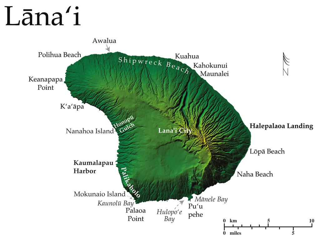
2 Läna i is a single shield that formed from summit eruptions and along three rift zones between 1.2 and 1.46 Ma; a classic example of a Hawaiian shield with a gently sloping profile. The small sub-circular island has 76 km of general coastline, and a dry climate with minimal stream activity. Similar to Moloka i, overgrazing of domestic and feral animals in the 19 th century and widespread deforestation on Läna i have drastically changed the stability of the soil. The vegetation has never fully recovered and there is considerable wind erosion on the island (Macdonald et al. 1986). Three paved roads all lead to the coast from centrally located Läna i City, but a network of four wheel drive roads criss-cross the island from the coast to lookouts atop steep sea cliffs. The edges of the island bear the marks of both wind and wave erosion. Läna i is different from the other Hawaiian islands however, because north and northeast Pacific swells are blocked by the islands of Maui and Moloka i, thus protecting Läna i from this source of erosive energy. Along the northern coastal terrace from Kuahua to Awalua windy conditions have led to the development of a series of sandy beaches and low sand dunes that are fronted offshore by a narrow fringing reef. The beaches, known collectively as Shipwreck Beach, extend along ~13 km of shoreline between Kahokunui beach (to the east) and Polihua Beach (to the west). These beaches are composed mostly of calcareous sand punctuated by


3 expanses of lithified beachrock. Rocky cobble and boulder deltas occur at the mouths of numerous small streams, which become shallow gulches as they descend from interior Läna i. Wind transported sediments from the island s northeastern mountains lie in suspension directly offshore, while shallow gulches, between the windward mountains and the coast, provide a route to the sea for terrigenous material during severe rain storms. The narrow Polihua Beach marks the west end of Shipwreck Beach, and the fringing reef. Polihua is the longest calcareous beach on Läna i, and extends across 2.4 km of the northwest corner of the island. Between Polihua and Nänähoa, the coast is rocky and wave eroded with only small offshore coral patches and no calcareous sand. The coast wraps the broad, elongate, westernmost end of the island at Keanapapa Pt. and becomes gradually steeper and more irregular south of the point. Southeast of Keanapapa are numerous sea caves and arches carved into rocky headlands, and offshore rocky islets occur along the

4 coast. The wave-beaten character of the coast extends the length of the west and southern coast, a signal of the erosive power of southwestern Kona storm waves. From K a ä pa to Nänähoa, the gently sloping uplands of western Läna i are cropped into blunt sea cliffs that periodically release boulders to narrow platforms fronting the headlands below (Fletcher et al. 2002). Offshore of Nänähoa lies a beautiful assembly of sea stacks, isolated by the retreating coast. The Nänähoa sea stacks are near the mouth of Honopü Gulch, one of the few stream gulches that have cut through the thickness of the shield down to sea level on the east side, where many others end as hanging valleys. Between Nänähoa and Kaumalapau Harbor the sea cliffs reach heights of 105 m and the coast maintains an irregular character to the south, punctuated by low-lying embayments. These east-facing embayments are exposed to the open ocean. However, the north point of the largest embayment, Kaumalapau Bay, is a curved arm that wraps the north portion of the semi-circular bay to point due south at the tip. The main Läna i shield reveals the mechanism of its landward retreat in large rockslides and slumps along the southwestern coast. This creates great vertical gouges in the Pali wall, producing tall piles of rocky debris that fan out along the shoreline where they are eventually reworked and washed away by

5 waves (Macdonald et al. 1986; Fletcher et al. 2002). South of Kaumalapau Harbor the sea cliffs rise up to 300 m above the ocean along the Palikaholo, extending to Mokunaio at the southwest corner of the island near Palaoa Pt. This portion of the wave-truncated shield affords exceptional cross-sectional views of layered pähoehoe flows, particularly because the arid conditions on the island have prevented extensive stream erosion. A layer of red colluvium up to 0.5 m thick lies between the lava flows in the cliff along the Palikaholo ~1 km south of Kaumalapau, this is an indication of an erosional period between flows, and is unusual on Läna i (Macdonald et al. 1986). Less then 2 km northwest of Kaunolü, the Kaholo coastal cliffs cut across the southwest rift zone of Läna i. Here, numerous nearly vertical dikes and the cross section of a small shield are exposed in the cliff wall (Macdonald et al. 1986). The sea cliffs are reduced to just 30 m in height as they approach southwest corner of Läna i at Kaunolü Bay on Palaoa Pt. East of Palaoa Pt. the shoreline has a southern exposure and becomes increasingly irregular with small embayments and caves carved into the steep rocky headlands. This wave-eroded shoreline has left numerous isolated rock islets offshore. The Mänele-Hulopo e Marine Life Conservation District lies along the

6 central south shore where the low-lying embayments at Hulopo e and Mänele interrupt a sea cliff coast. Protruding out into the ocean between the bays is Pu u pehe, an eroded volcanic cinder and spatter cone that has been eroded into a cove at its seaward end. This cove is bordered on the west by a low-lying rocky point that harbors a wide crescent of white sand in its lee, and on the east by a steep cliff with a wave cut terrace running its length along the inside of the cove. The large rock islet isolated offshore of the east point has been separated from the remnant cone by wave erosion. Of additional interest in this area is the famed Hulopo e Gravels hypothesized by Moore and Moore (1984) as having been emplaced by a catastrophic tsunami Ca.100, 000 yrs Bp, resulting from a large landslide. Much has been made of this event with deposits and features on the Australian shoreline and elsewhere having been attributed to its occurrence. Rubin et al. (2000) however find coral gravels on Lana i dating from 3 separate interglacial sea level highstands, and the elevations of the Hulopo e Gravels to be the result of flexural uplift of the island. Near Naha and Löpä southeast Läna i is a narrow low lying coastal terrace fronted nearshore by a narrow and continuous fringing reef. Vegetation overhangs the shoreline here and indicates that the coast is actively retreating.

7 Beyond the easternmost point near Halepalaoa Landing the coast turns to face northeast and is out of direct exposure to Kona storm waves, allowing the fringing reef to widen offshore while the coast is skirted by broad expanses of alluvium and beaches. Southeast of Maunalei massive lithified sand dunes extend as far as 3.2 km inland and reach heights of 285 m. Alluvium deltas tend to form at the base of large erosional gulches along this coast, where they lie along the shoreline where they are deposited.
Coastal management has lagged behind the growth in population leading to problems with pollution
 Fifty percent of the population of the industrialized world lives within 100 km of a coast. Coastal management has lagged behind the growth in population leading to problems with pollution and natural
O ahu is the third largest Hawaiian island with 180 km of general. coastline that contours a highly irregular shape that was greatly influenced by
 O ahu is the third largest Hawaiian island with 180 km of general coastline that contours a highly irregular shape that was greatly influenced by two massive landslides, that removed ~1/3 of the northeastern
Coasts. 1. Coastal Processes. 1.1 Coastal erosion. 1.2 Sediment transport. Coastal Processes and Landforms. i. Hydraulic action
 Coasts Coastal Processes and Landforms 1. Coastal Processes 1.1 Coastal erosion i. Hydraulic action When waves strike against a rock surface, the waves trap air in the rock joints. This air is compressed
Shore - place where ocean meets land Coast - refers to the larger zone affected by the processes that occur at this boundary.
 Waves, Beaches, and Coasts Shore - place where ocean meets land Coast - refers to the larger zone affected by the processes that occur at this boundary. Waves: energy moving through water The height of
Overview. Beach Features. Coastal Regions. Other Beach Profile Features. CHAPTER 10 The Coast: Beaches and Shoreline Processes.
 Overview CHAPTER 10 The Coast: Beaches and Shoreline Processes Coastal regions constantly change. The beach is a dominant coastal feature. Wave activity continually modifies the beach and coastal areas.
General Coastal Notes + Landforms! 1
 General Coastal Notes + Landforms! 1 Types of Coastlines: Type Description Primary Coast which is essentially in the same condition when sea level stabilized Coastline after the last ice age, younger.
There are many different kinds of beaches which are generally characterized by the dominance of waves, tides, rivers and currents, and in particular
 Fig. 11-11, p. 253 There are many different kinds of beaches which are generally characterized by the dominance of waves, tides, rivers and currents, and in particular differ by the amount of energy, which
Montessori for Everyone 2013 Types of Coastlines
 Coast The coast is the part of the land that borders the sea. It is subject to constant change, as the result of the waves and deposits carried by water onto the land. Coastline The coastline is where
1.5 How do ocean waves and currents change the face of coastal areas? (Chapter 3)
") 1.5 How do ocean waves and currents change the face of coastal areas? (Chapter 3) 1. Hydraulic Action/Pressure - air being forced into crack in rocks. 2. Corrosion (Solution) Minerals such as calcium carbonate
1.5 How do ocean waves and currents change the face of coastal areas? (Chapter 3) 1. Hydraulic Action/Pressure - air being forced into crack in rocks. 2. Corrosion (Solution) Minerals such as calcium carbonate
Oceans and Coasts. Chapter 18
 Oceans and Coasts Chapter 18 Exploring the oceans The ocean floor Sediments thicken and the age of the seafloor increases from ridge to shore The continental shelf off the northeast United States Constituent
Shorelines Earth - Chapter 20 Stan Hatfield Southwestern Illinois College
 Shorelines Earth - Chapter 20 Stan Hatfield Southwestern Illinois College The Shoreline A Dynamic Interface The shoreline is a dynamic interface (common boundary) among air, land, and the ocean. The shoreline
Essentials of Oceanography Eleventh Edition
 Chapter Chapter 1 10 Clickers Lecture Essentials of Oceanography Eleventh Edition The Coast: Beaches and Shoreline Processes Alan P. Trujillo Harold V. Thurman Chapter Overview Coastal regions have distinct
LAB: WHERE S THE BEACH
 Name: LAB: WHERE S THE BEACH Introduction When you build a sandcastle on the beach, you don't expect it to last forever. You spread out your towel to sunbathe, but you know you can't stay in the same spot
Chapter 10 Lecture Outline. The Restless Oceans
 Chapter 10 Lecture Outline The Restless Oceans Focus Question 10.1 How does the Coriolis effect influence ocean currents? The Ocean s Surface Circulation Ocean currents Masses of water that flow from one
COASTAL SYSTEMS WAVE ENERGY
 WAVE ENERGY The energy of a wave determines its ability to erode and transport material on the coast Wave energy depends on the fetch, the distance the wind has blown the wave Wind strength and wind duration
Label the diagram below with long fetch and short fetch:
 Coastal Processes Coasts are shaped by the sea and the action of waves. The processes that take place are erosion, transportation and deposition. The power of waves is one of the most significant forces
4/20/17. #30 - Coastlines - General Principles Coastlines - Overview
 Writing Assignment Due one week from today by 11:59 pm See main class web pages for detailed instructions Essays will be submitted in Illinois Compass (instructions later) Pick one: Earthquakes, tsunamis,
COASTAL ENVIRONMENTS. 454 lecture 12
 COASTAL ENVIRONMENTS Repeated movement of sediment & water constructs a beach profile reflecting the balance between average daily or seasonal wave forces and resistance of landmass to wave action Coasts
1 Shoreline Erosion and Deposition
 CHAPTER 12 1 Shoreline Erosion and Deposition SECTION Agents of Erosion and Deposition BEFORE YOU READ After you read this section, you should be able to answer these questions: What is a shoreline? How
1.5 Understand how ocean waves and currents change the face of coastal areas. (Chapter 3)
") 1.5 Understand how ocean waves and currents change the face of coastal areas. (Chapter 3) 1. Hydraulic Action/Pressure - air being forced into crack in rocks. 2. Corrosion (Solution) Minerals such as calcium
1.5 Understand how ocean waves and currents change the face of coastal areas. (Chapter 3) 1. Hydraulic Action/Pressure - air being forced into crack in rocks. 2. Corrosion (Solution) Minerals such as calcium
Geology of the Hawaiian Islands
 Geology of the Hawaiian Islands Class 24 8 April 2004 Any Questions? Rise and fall of sea level and its effect on Hawai`i Sea level Has fluctuated up and down many times in the geologic past Evidence?
Monterey Peninsula College
 Introduction to Google Earth Name Goals 1. To become proficient at using the basic features of Google Earth. 2. To recognize differences in coastal features between the east and west coast of North America.
Nearshore Sediment Transport What influences the loss of sediment on Beaches? - Waves - Winds - Tidal Currents - River discharge - Runoff
 Tides & Beaches Nearshore Sediment Transport What influences the loss of sediment on Beaches? - Waves - Winds - Tidal Currents - River discharge - Runoff Oceans Ocean Topography Physical Structure of the
Reading Material. Inshore oceanography, Anikouchine and Sternberg The World Ocean, Prentice-Hall
 Reading Material Inshore oceanography, Anikouchine and Sternberg The World Ocean, Prentice-Hall BEACH PROCESSES AND COASTAL ENVIRONMENTS COASTAL FEATURES Cross section Map view Terminology for Coastal
Earth Science Chapter 16 Section 3 Review
 Name: Class: Date: Earth Science Chapter 16 Section 3 Review Multiple Choice Identify the choice that best completes the statement or answers the question. 1. The movement of water that parallels the shore
Chapter. The Dynamic Ocean
 Chapter The Dynamic Ocean An ocean current is the mass of ocean water that flows from one place to another. 16.1 The Composition of Seawater Surface Circulation Surface Currents Surface currents are movements
Coastal Change and Conflict
 Coastal Change and Conflict Outline of the Topic Contrasting Coasts why do all coasts not look the same? Geology of the coast the impact rock structure has on the coastline Waves Constructive and destructive
Chapter - Oceans and Coasts
 Chapter - Oceans and Coasts Discussion: What do oceans contribute to the environment of Earth? How do Earth s major systems relate to the oceans? Oceans and Coasts Oceans are important - Thermal regulation
TITLE: COASTAL EROSION AND LANDFORMS.
 TITLE: COASTAL EROSION AND LANDFORMS. AIM: What are the factors that influence the formation of coastal features along Fishing Pond beach Trinidad? LOCATION OF FIELD STUDY: The study was carried out in
Chapter 20 Lecture. Earth: An Introduction to Physical Geology. Eleventh Edition. Shorelines. Tarbuck and Lutgens Pearson Education, Inc.
 Chapter 20 Lecture Earth: An Introduction to Physical Geology Eleventh Edition Shorelines Tarbuck and Lutgens The Shoreline: A Dynamic Interface The Coastal Zone The shoreline is constantly modified by
Chesil Beach, Dorset UK High energy, shingle coastline. Brighton Beach, Sussex UK Pebble beach
 Beaches: Depositional landform Extends from the highest high tide to the lowest low tide. Very important temporary store in coastal system. Accretion: sediment returning to the visible portion of a beach
1 Shoreline Erosion and Deposition
 CHAPTER 12 1 Shoreline Erosion and Deposition SECTION Agents of Erosion and Deposition BEFORE YOU READ After you read this section, you should be able to answer these questions: What is a shoreline? How
OECS Regional Engineering Workshop September 29 October 3, 2014
 B E A C H E S. M A R I N A S. D E S I G N. C O N S T R U C T I O N. OECS Regional Engineering Workshop September 29 October 3, 2014 Coastal Erosion and Sea Defense: Introduction to Coastal Dynamics David
Beach profile surveys and morphological change, Otago Harbour entrance to Karitane May 2014 to June 2015
 Beach profile surveys and morphological change, Otago Harbour entrance to Karitane May 2014 to June 2015 Prepared for Port Otago Ltd Martin Single September 2015 Shore Processes and Management Ltd Contact
Lecture Outlines PowerPoint. Chapter 15 Earth Science, 12e Tarbuck/Lutgens
 Lecture Outlines PowerPoint Chapter 15 Earth Science, 12e Tarbuck/Lutgens 2009 Pearson Prentice Hall This work is protected by United States copyright laws and is provided solely for the use of instructors
3.9 FROM ISLANDS TO ATOLLS
 3.9 1 3.9 FROM ISLANDS TO ATOLLS OBJECTIVES The students Listen to a description of the formation of volcanic islands, fringing reefs, barrier reefs, and atolls. Observe and participate in a simulation
Marginal Marine Environments
 Marginal Marine Environments Delta: discrete shoreline protuberances formed where rivers enter oceans, semi-enclosed seas, lakes or lagoons and supply sediment more rapidly than it can be redistributed
Chapter 12: Coasts (after a brief review of Tides)
") Chapter 12: Coasts (after a brief review of Tides) 1 Questions from previous classes: What happens when a wave meets a current? wave = people walking current = bus If wave goes with the current, the wave
Chapter 12: Coasts (after a brief review of Tides) 1 Questions from previous classes: What happens when a wave meets a current? wave = people walking current = bus If wave goes with the current, the wave
An Update of Coastal Erosion in Puerto Rico
 Jack Morelock and Maritza Barreto An Update of Coastal Erosion in Puerto Rico Department of Marine Sciences, University of Puerto Rico at Mayagüez and Geography Department, University of Puerto Rico at
Wind Blow-out Hollow Generated in Fukiage Dune Field, Kagoshima Prefecture, Japan
 R. Nishi Wind Blow-out Hollow Generated in Fukiage Dune Field, Kagoshima Prefecture, Japan Ryuichiro Nishi, Li Elikson and Myokhin PREFACE A sand dune is vulnerable to severe waves and wind. Therefore,
Figure 1. Schematic illustration of the major environments on Mustang Island.
 STOP #1: PACKERY CHANNEL BEACH TO BAY We will start this field guide near the north jetty of Packery Channel and hike across the island to Corpus Christi Bay (fig. 1). The island emerges from the Gulf
/50. Physical Geology Shorelines
 Physical Geology Shorelines Multiple Guess: (You know the drill 2 points each) 1. The path of movement of a water particle in a wave at sea is 1. circular 2. horizontal 3. vertical 4. elliptical 5. none
Coastal Processes and Landforms
 Coastal Processes and Landforms These icons indicate that teacher s notes or useful web addresses are available in the Notes Page. This icon indicates that the slide contains activities created in Flash.
Beaches Unit (4.5 pts)
") T. James Noyes, El Camino College Beaches Unit (Topic 6A) page 1 Name: Section: Beaches Unit (4.5 pts) Beaches and Shorelines Are Always Changing Waves are slowly and inexorably altering the shoreline,
T. James Noyes, El Camino College Beaches Unit (Topic 6A) page 1 Name: Section: Beaches Unit (4.5 pts) Beaches and Shorelines Are Always Changing Waves are slowly and inexorably altering the shoreline,
Australian Coastal Councils Conference
 Australian Coastal Councils Conference Kiama March 2019 Where Has My Beach Gone? (and what can I do about it?) Dr Andrew McCowan Water Technology Where Has My Beach Gone? Where Has My Beach Gone? Where
Natural Bridges Field Trip Activity
 Natural Bridges Field Trip Activity This is due in class on MONDAY- March 1 - not in sections! Name TA: NOTE ON THE GRADING OF THIS ASSIGNMENT: Many of the questions below (especially in the tidepool part)
The Composition of Seawater
 The Composition of Seawater Salinity Salinity is the total amount of solid material dissolved in water. Most of the salt in seawater is sodium chloride, common table salt. Element Percent Element Percent
The Sea Geography Notes JC-Learn. JC-Learn. Geography Notes The Sea. 1 P a g e
 JC-Learn Geography Notes The Sea 1 P a g e The Sea *Here, you can choose to study the chapter on glaciation or the one on the sea, or even both, because whenever these topics come up in the Junior Cert
WIND SPEED LENGTH OF TIME WIND BLOWS (Duration) DISTANCE OVER WHICH IT BLOWS (Fetch)
 DISTANCE OVER WHICH IT BLOWS (Fetch)") WAVES Up and down movement of ocean surface Transportation of energy across the water over vast distances If not stopped by anything, waves can travel entire oceans Size and speed depend upon: WIND SPEED
WAVES Up and down movement of ocean surface Transportation of energy across the water over vast distances If not stopped by anything, waves can travel entire oceans Size and speed depend upon: WIND SPEED
Anatomy of Coastal Regions
 The Coast I. BEACH ANATOMY Anatomy of Coastal Regions Terms for different parts of beaches and coastal regions Are all about ENERGY- ie, where the ocean s energy Mostly through tides and waves, and shape
page - Laboratory Exercise #5 Shoreline Processes
 page - Laboratory Exercise #5 Shoreline Processes Section A Shoreline Processes: Overview of Waves The ocean s surface is influenced by three types of motion (waves, tides and surface currents). Shorelines
Chronic coastal erosion is a statewide problem
 Chronic coastal erosion is a statewide problem 1 Seawalls are constructed where there is erosion, but they do not solve the erosion they often worsen it along adjacent shores. Hawaii needs erosion solutions.
Volume and Shoreline Changes along Pinellas County Beaches during Tropical Storm Debby
 Volume and Shoreline Changes along Pinellas County Beaches during Tropical Storm Debby Ping Wang and Tiffany M. Roberts Coastal Research Laboratory University of South Florida July 24, 2012 Introduction
Building Coastal Resiliency at Plymouth Long Beach
 Building Coastal Resiliency at Plymouth Long Beach Department of Marine and Environmental Affairs March 30, 2017 Introducing Green Infrastructure for Coastal Resiliency Plymouth Long Beach & Warren s Cove
Define the key terms: - Abrasion - Attrition - Hydraulic action - Solution. Y11 Coasts
 Define the key terms: - Abrasion - Attrition - Hydraulic action - Solution Abrasion caused by waves picking up material which is forced against the cliff face wearing it away Attrition where stones and
Beach Erosion at Waimea Bay, Oahu, Hawaii l
 Pacific Science (1982), vol. 36, no. 1 1982 by the University of Hawaii Press. All rights reserved Beach Erosion at Waimea Bay, Oahu, Hawaii l J. F. CAMPBELL 2 and D. J. HWANG 2 ABSTRACT: Waimea Beach
SUBJECT: EARTH SCIENCE PAPER: THE DYNAMIC EARTH. Code : 27 COASTAL PROCESSES AND LANDFORMS PROF. A. BALASUBRAMANIAN
 SUBJECT: EARTH SCIENCE PAPER: THE DYNAMIC EARTH Code : 27 TOPIC: COASTAL PROCESSES AND LANDFORMS BY PROF. A. BALASUBRAMANIAN Objectives After attending this module, the user would be able to understand
The Case of the Disappearing Shoreline
 Name The Case of the Disappearing Shoreline Humans change the earth's climate in many ways. One change is the increase of carbon dioxide in the atmosphere. As we burn more fossil fuels, we release more
The Physical and Human Causes of Erosion. The Holderness Coast
 The Physical and Human Causes of Erosion The Holderness Coast By The British Geographer Situation The Holderness coast is located on the east coast of England and is part of the East Riding of Yorkshire;
Chapter 15. The Work of Wind and Deserts
 Chapter 15 The Work of Wind and Deserts Introduction What is desertification? Desertification is the expansion of deserts into formerly productive lands. These expansions destroy croplands and rangelands.
Coastal Processes Day Criccieth
 Coastal Processes Rivers (Conwy) Rivers (Peris) Urban Studies Lowland Glaciation Tourism and National Parks Soils Sand Dunes Upland Glaciation Rural Settlements The Centre and Staff Fieldwork Equipment
Identify one factor which influences wave strength (1 Mark) Factors which affect wave strength
 Factors which affect wave strength") Coasts revision Identify one factor which influences wave strength (1 Mark) Factors which affect wave strength Identify one factor which influences wave strength (1 Mark) Factors which affect wave strength
Coasts revision Identify one factor which influences wave strength (1 Mark) Factors which affect wave strength Identify one factor which influences wave strength (1 Mark) Factors which affect wave strength
MAPS AND AERIAL PHOTOS REVISION
 MAPS AND AERIAL PHOTOS REVISION IF THE FOLLOWING COMES UP IN THE SHORT QUESTIONS REMEMBER SCALE OF 1:1,100,000,000 MAP FROM A WORLD ATLAS LARGE AREAS WITH LITTLE DETAIL 1:250,000 SCALE OF CAR ATLAS MAP
Long Beach Island Holgate Spit Little Egg Inlet Historical Evolution Introduction Longshore Transport Map, Survey and Photo Historic Sequence
 Appendix B Long Beach Island Holgate Spit Little Egg Inlet Historical Evolution Introduction The undeveloped southern end of Long Beach Island (LBI) is referred to as the Holgate spit as it adjoins the
FINAL REPORT FOR 2013 ON THE CONDITION OF THE MUNICIPAL OCEANFRONT BEACHES THE BOROUGH OF AVALON, CAPE MAY COUNTY, NEW JERSEY
 FINAL REPORT FOR 2013 ON THE CONDITION OF THE MUNICIPAL OCEANFRONT BEACHES THE BOROUGH OF AVALON, CAPE MAY COUNTY, NEW JERSEY View from 12 th Street to the south taken February 28, 2013, following completion
Constructive waves build beaches. Each wave is low. As the wave breaks it carries material up the beach in its. material will then be deposited as
 Constructive waves Constructive waves build beaches. Each wave is low. As the wave breaks it carries material up the beach in its swash. The beach material will then be deposited as the backwash soaks
Shorelines Earth Chapter 20 Chapter 20 Shorelines The Shoreline: A Dynamic Interface Cape Cod and Point Reyes Hurricane Sandy
 1 2 3 4 5 6 7 8 9 10 11 12 13 Shorelines Earth Chapter 20 Chapter 20 Shorelines The Shoreline: A Dynamic Interface The interface is the common boundary where different parts of a system interact. The Coastal
Estuarine Shoreline Stabilization
 Estuarine Shoreline Stabilization Property Owner s Guide to Determining the Most Appropriate Stabilization Method Estuarine shorelines are dynamic features that experience continued erosion. Land is lost
Montserrat. Wise practices for coping with. i b bea n Se a
 Wise practices for coping with Montserrat Car i b bea n Se a Fisheries Division, Montserrat Physical Planning Department, Montserrat University of Puerto Rico, Sea Grant College Program Caribbean Development
Anguilla. Wise practices for coping with. i b bea n Se a
 Wise practices for coping with Anguilla Car i b bea n Se a Department of Fisheries and Marine Resources, Anguilla Department of Physical Planning, Anguilla University of Puerto Rico, Sea Grant College
Julebæk Strand. Effect full beach nourishment
 Julebæk Strand Effect full beach nourishment Aim of Study This study is a part of the COADAPT funding and the aim of the study is to analyze the effect of beach nourishment. In order to investigate the
3/9/2013. Build house on cliff for a view of the ocean - be one with said view Pearson Education, Inc. Shorelines: summary in haiku form
 Introduction to Environmental Geology, 5e Edward A. Keller Shorelines: summary in haiku form Chapter 11 Coastal Processes Lecture Presentation prepared by X. Mara Chen, Salisbury University Build house
Figure79. Location map for the 10 NJBPN profile sites in Atlantic County, NJ 155
 154 Figure79. Location map for the 10 NJBPN profile sites in Atlantic County, NJ 155 ATLANTIC COUNTY SPRING 2009 to FALL 2010 The Atlantic County coastline consists of three barrier islands. Between Little
DUNE STABILIZATION AND BEACH EROSION
 DUNE STABILIZATION AND BEACH EROSION CAPE HATTERAS NATIONAL SEASHORE NORTH CAROLINA ROBERT DOLAN PAUL GODFREY U. S. DEPARTMENT OF INTERIOR NATIONAL PARK SERVICE OFFICE OF NATURAL SCIENCE WASHINGTON, D.
ALTERNATIVES FOR COASTAL STORM DAMAGE MITIGATION
 ALTERNATIVES FOR COASTAL STORM DAMAGE MITIGATION Dave Basco Old Dominion University, Norfolk, Virginia, USA National Park Service Photo STRUCTURAL (changes to natural, physical system) hardening (seawalls,
Soft Designs for a Harsh Climate: Trends in Coastal Engineering
 Alaska Department of Transportation & Public Facilities Ruth Carter, PE, and Harvey Smith, PE Coastal Engineering Section 20 October 2014 Soft Designs for a Harsh Climate: Trends in Coastal Engineering
New Jersey Coastal Zone Overview. The New Jersey Beach Profile Network (NJBPN) 3 Dimensional Assessments. Quantifying Shoreline Migration
 3 Dimensional Assessments. Quantifying Shoreline Migration") New Jersey Coastal Zone Overview The New Jersey Beach Profile Network (NJBPN) Objectives Profile Locations Data Collection Analyzing NJBPN Data Examples 3 Dimensional Assessments Methodology Examples Quantifying
New Jersey Coastal Zone Overview The New Jersey Beach Profile Network (NJBPN) Objectives Profile Locations Data Collection Analyzing NJBPN Data Examples 3 Dimensional Assessments Methodology Examples Quantifying
Name: Form: 2.To know the difference between Constructive and Destructive wave # $
 Name: Form: Landforms and landscape processes: COASTS 1. To know what factors affect the strength of waves # $ 2.To know the difference between Constructive and Destructive wave # $ 3. To be able to draw
Ocean Waves. Capillary. Gravity. Wind generated. Tides Tsunamis Seiches
 Ocean Waves Capillary Wind generated Gravity Tides Tsunamis Seiches Capillary waves are driven by the surface tension produced by electrically polarized water molecule San Pedro Lighthouse Waves are alternate
RE: Hurricane Matthew Beach Damage Assessment and Recommendations [CSE 2416]
![RE: Hurricane Matthew Beach Damage Assessment and Recommendations [CSE 2416]](/thumbs/83/87675702.jpg "RE: Hurricane Matthew Beach Damage Assessment and Recommendations [CSE 2416]") October 25, 2016 Iris Hill Town Administrator Town of Edisto Beach 2414 Murray St Edisto Beach SC 29438 RE: Hurricane Matthew Beach Damage Assessment and Recommendations [CSE 2416] Dear Iris, Hurricane
October 25, 2016 Iris Hill Town Administrator Town of Edisto Beach 2414 Murray St Edisto Beach SC 29438 RE: Hurricane Matthew Beach Damage Assessment and Recommendations [CSE 2416] Dear Iris, Hurricane
BEACH PROCESSES AND COASTAL ENVIRONMENTS
 BEACH PROCESSES AND COASTAL ENVIRONMENTS COASTAL FEATURES Cross section Map view TOPICS: Terminology Waves Beach Morphology Barriers Coastal Migration Tides Tidal Flats and Marshes Sediment Budgets Human
WHAT ARE THE MAJOR COASTLINE FEATURES AND WAVE CHARACTERISTICS WHICH INDICATE THAT MARINE EROSION IS ACTIVE ON THE EASTERN SIDE OF THE
 WHAT ARE THE MAJOR COASTLINE FEATURES AND WAVE CHARACTERISTICS WHICH INDICATE THAT MARINE EROSION IS ACTIVE ON THE EASTERN SIDE OF THE ENTRANCE TO DISCOVERY BAY HARBOUR IN JAMAICA? JEFFREY JOHNSON YORK
Wave-dominated embayed beaches. Andrew D Short School of Geosciences University of Sydney
 Wave-dominated embayed beaches Andrew D Short School of Geosciences University of Sydney Wave-dominated embayed beaches wave-dominated beaches embayed beaches morphodynamics of W-D embayed beaches circulation,
Coastal Zones. Coastal Zones
 Page 1 of 15 EENS 3050 Tulane University Natural Disasters Prof. Stephen A. Nelson Coastal Zones Coastal Zones A coastal zone is the interface between the land and water. These zones are important because
15 Coasts and Changing Sea Levels
 CHAPTER 15 Coasts and Changing Sea Levels PEOPLE LIVE ALONG COASTS for a variety of good reasons. Oceans moderate climate, supply fish and other sea resources, provide transportation for people and goods,
4/20/17. #32 - Coastal Erosion Case Histories - Lake Michigan
 Writing Assignment Due Monday by 11:59 pm #32 - Coastal Erosion Case Histories - Lake Michigan See main class web pages for detailed instructions Submit papers Illinois Compass No copying: Compass will
Delaware Chapter Surfrider Foundation - Indian River Inlet Monitoring
 Delaware Chapter Surfrider Foundation - Indian River Inlet Monitoring In 2012, the Delaware Surfrider Foundation Chapter formed the Surf Quality and Access Committee to focus on issues such as surf spot
ALTERNATIVES FOR COASTAL STORM DAMAGE MITIGATION AND FUNCTIONAL DESIGN OF COASTAL STRUCTURES
 The University of the West Indies Organization of American States PROFESSIONAL DEVELOPMENT PROGRAMME: COASTAL INFRASTRUCTURE DESIGN, CONSTRUCTION AND MAINTENANCE A COURSE IN COASTAL DEFENSE SYSTEMS I CHAPTER
The evolution of beachrock morphology and its influence on beach morphodynamics
 The evolution of beachrock morphology and its influence on beach morphodynamics Robert J. Turner Division of Natural Sciences, Southampton College, 239 Montauk Highway, Southampton, NY 11968, U.S.A. email:
Dynamic Shoreline. Why do we care? Loss of land Damage to structures Recreation
 Dynamic Shoreline Why do we care? Loss of land Damage to structures Recreation Coastal Water Movement Waves provide the energy Through breaking As waves shoal Speed decreases Height increases Wavelength
Imagine that you can see a side view of a wave as it approaches a beach. Describe how the wave changes as the wave approaches the beach.
 Geology 101 Name Reading Guide for Ch. 19: Shores and Coastal Processes (p. 612) Waves, Currents, and Tides (p. 614) Waves and Currents (p. 614) Imagine that you can see a side view of a wave as it approaches
HARBOUR SEDIMENTATION - COMPARISON WITH MODEL
 HARBOUR SEDIMENTATION - COMPARISON WITH MODEL ABSTRACT A mobile-bed model study of Pointe Sapin Harbour, in the Gulf of St. Lawrence, resulted in construction of a detached breakwater and sand trap to
Nevis. Wise practices for coping with
 Wise practices for coping with Nevis Caribbean Sea Nevis Historical and Conservation Society Department of Physical Planning, Natural Resources and Environment, Fisheries Division University of Puerto
The Dynamic Coast. Right Place Resources. A presentation about the interaction between the dynamic coast and people
 The Dynamic Coast Houses threatened by coastal erosion in California Right Place Resources A presentation about the interaction between the dynamic coast and people For the rest of the presentations in
SHOREHAM BEACH LOCAL NATURE RESERVE
 SHOREHAM BEACH LOCAL NATURE RESERVE Coastal Geography Education Programme 2014-15 S. Savage 2014 COASTAL GEOGRAPHY OPPORTUNITIES Shoreham Beach Shoreham Beach is a shingle spit formed over many centuries
WHAT IS A TSUNAMI? happens.nz. Long or Strong GET GONE TSUNAMI 101
 WHAT IS A TSUNAMI? A tsunami is a series of powerful waves with strong currents. They are mostly caused by underwater or coastal earthquakes, and sometimes by underwater landslides or volcanic eruptions.
Map 8: Ayrshire Coast: Ardrossan North Bay to Stevenston Pier Map Content Descriptions
 Map 8: Ayrshire Coast: Ardrossan North Bay to Stevenston Pier Map Content Descriptions 1. Built Heritage and Archaeology A total of twenty four sites were recorded in the area covered by Map 8. Of these
Inner-Bank Erosion Processes and Solutions at Coastal Inlets
 Inner-Bank Erosion Processes and Solutions at Coastal Inlets by William C. Seabergh PURPOSE: The Coastal and Hydraulics Engineering Technical Note (CHETN) herein provides information on erosion which occurs
Q1. What are the primary causes/contributors to coastal erosion at Westshore and the concept of longshore / littoral drift.
 Q1. What are the primary causes/contributors to coastal erosion at Westshore and the concept of longshore / littoral drift. In order of (timing related) contribution to present problem 1. Beach is too
ATLANTIC COUNTY 2006 to 2008
 ATLANTIC COUNTY 2006 to 2008 The Atlantic County oceanfront shoreline consists of three barrier islands where the northern one, Little Beach Island and a third of the second, Brigantine Island, are undeveloped