PRACTICE STANDARDS AND NR 328. Choosing a Technique and Getting a Permit
|
|
|
- Jean Montgomery
- 5 years ago
- Views:
Transcription
1 PRACTICE STANDARDS AND NR 328 Choosing a Technique and Getting a Permit
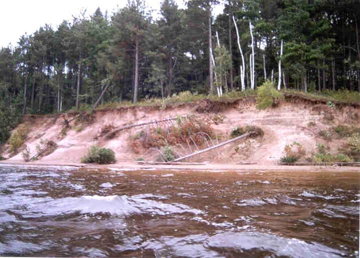
2 CHOOSING A TECHNIQUE Define cause of erosion Upland runoff? Impervious areas? Velocities? Wave energies? Boat or wind generated? Ice action? Prevailing wind direction? Water level fluctuations? Floods or Droughts? Groundwater seeps? Up gradient slope and height of bank? Stability of native soils? Fill soils? Shear stresses on stream banks?
3 VEGETATIVE TREATMENT POTENTIAL When is vegetation going to be enough to stabilize the site? Minimal fetch distance (<0.5-1 mile) Protected cove or bay (not point or island) Shoreline is facing such that prevailing winds do not reach it frequently (i.e. faces east and rarely gets a westerly wind) When boat traffic and associated waves are not common or constant (i.e. no motorized traffic allowed, no public landing, NOT necessarily due to a SLOW NO WAKE zone as these are not enforced and usually increase the waves thrown) When water level fluctuations do not harm vegetation survival rates and/or success
4 OTHER DECIDING FACTORS Soil type is not conducive to slope stability at given angle without toe protection to prevent slip out Development of parcel is limiting such that there is not room to establish a stable slope (i.e. home too close to slope break or existing vertical walls) Channel or narrows in lake or controlled wake areas create constant wave action and vegetation can not get established Extreme ice action continuously removes or stresses soil/plants Vegetation unaltered by landowner is not handling the erosion intensities at the site (is the existing vegetation failing/) Cultural Resources limitations (i.e. burial sites) Biological/Habitat limitations Utility limitations (buried lines, overhead lines, setbacks) Access limitations (steep slopes, ice access, barge, etc.) Can you grow it and maintain it (watering/protection from Deer/etc.)
5 SHORE LAND RESTORATIONS Where do I fit in to this? (How can I receive funding or is it fundable?) DATCP Code 50 (history) Land and Water Plans at the County level Erosion Soil conservation Water quality Local priorities in each County dictate how they offer cost share funding Practices require a 10 year agreement with the landowners to maintain the practice
6 NRCS TECHNICAL STANDARDS/SPECIFICATIONS Standards provide the basis for design. Specifications provide the basis for construction. Standards and Specifications are used as minimum criteria for LCDS and NRCS Field Offices to provide cost sharing from both state and federal sources. Counties may use these standards as basis for regulation. Standards and Specifications can and do change often, consult with Technical Guide IV prior to design.
7 TOOLS - NRCS STANDARDS (FOUND IN NRCS TECHNICAL GUIDE IV) Riparian Forest Buffer 391 An area in which vegetation is enhanced or established to reduce or eliminate the movement of sediment, nutrient and other nonpoint source pollutants to an adjacent surface water resource or groundwater recharge area, to protect the banks of streams and lakes from erosion and to protect fish habitat. Shore land Habitat 643A Stream bank and Shoreline Protection 580
8 TOOLS - NRCS STANDARDS CONT D Stream bank and Shoreline Protection 580 Using vegetation or structures to stabilize and protect the banks of streams, lakes, estuaries or excavated channels against scour and erosion, or to protect fish habitat and water quality from degradation Most practices have a 10 year O&M Contract and longevity of design to last 10 years
9 NRCS TECHNICAL STANDARDS NRCS = Natural Resources Conservation Service Web page = Field Office Tech Guide Engineering Field Handbook Section IV Index of Practices Index of Construction Specifications
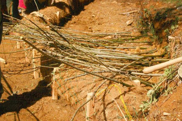
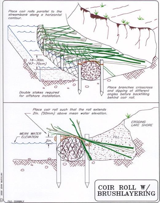
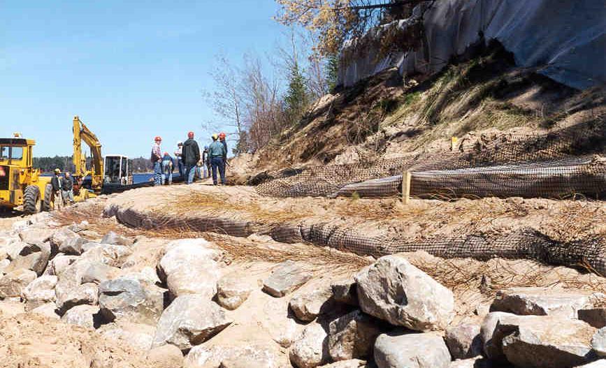
10 RELEVANT NRCS SPECIFICATIONS REFERENCED IN DESIGNS FOR SHORE LANDS (REMEMBER-SPECIFICATIONS ARE FOR CONSTRUCTION-NOT DESIGN) Wisconsin Construction Specification #1 - Clearing & Snagging WCS #2 - Excavation WCS #3 - Earth fill WCS #5 - Site Pollution Control (includes construction erosion) WCS #7 - Mobilization & Demobilization WCS #9 - Rock Riprap WCS #13 - Geotextiles WCS #20 - Soil Bioengineering WCS #21 - Structural Measures for Stream banks and Shorelines WCS #22 - Biodegradable or Temporary Breakwaters (Temporary Wave Barriers)
11 SO DO I NEED A PERMIT? (MAYBE) Working along a lakeshore: You just might need a permit from the local, state, and even federal government Always start local-check with the Town and or County Zoning office Next check with the state because most likely you will need a chapter 30 permits. Start at the following website: If in doubt-call your WDNR Water Management Specialist-these are regionally based folks that can help you out. The United States Army Corp of Engineers also has jurisdiction over waters of the United States. Start at the following website: Allow for time-permits may require a review period. Document whom and when you talked with a person.
12 WDNR TOOLS/CHAPTER 30 PERMITS Erosion Calculator on web page Surface Water Data Viewer on web page Erosion Intensity Score sheet (EI) Bank Erosion Potential Index (BEPI)-Stream bank WDNR Chapter 328
13
14


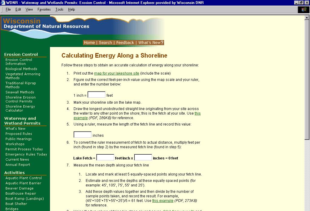
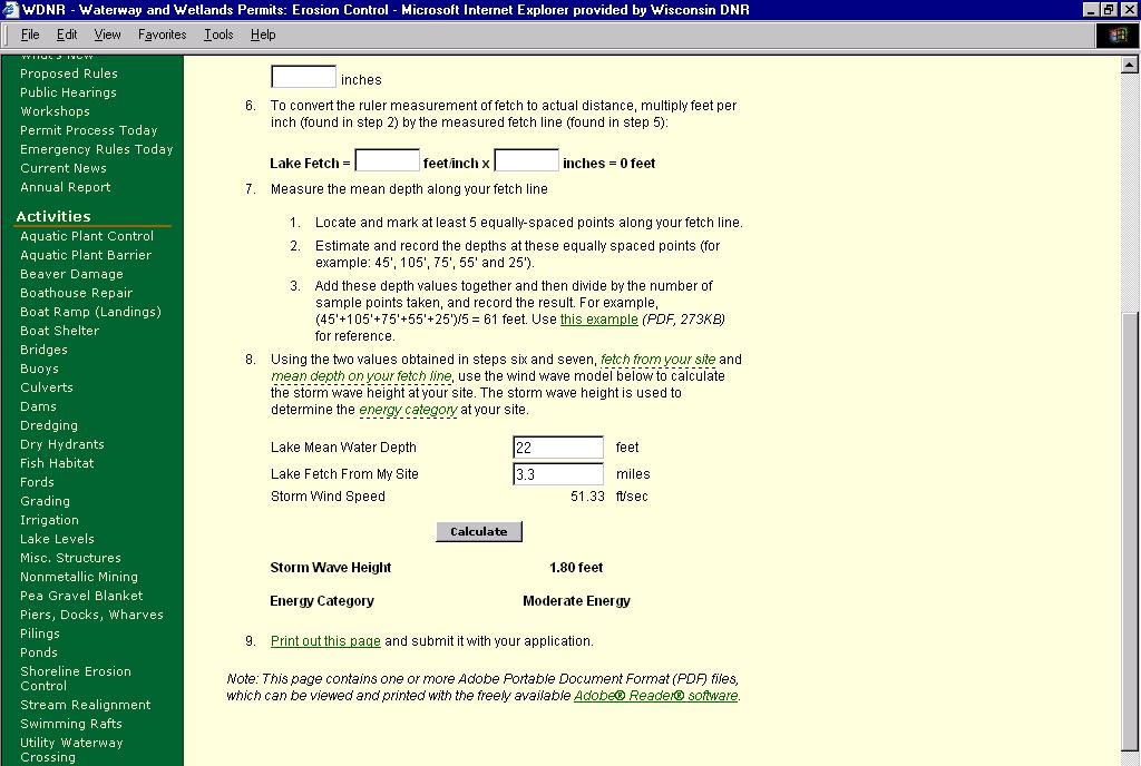
15 ENERGY CATEGORY Classifies Shoreline Sites Based on Erosion Severity Low Energy Moderate Energy High Energy < 1 foot feet >2.3 feet
16 HOW DO I FIGURE MY FETCH? -Obtain a topographic map or bathymetric map of your lake -Locate your site -Draw a line from your site to the opposite bank (the longest unobstructed straight line) -Look at the lake map, sum the recorded depths, then divide by the number of recorded values, (you need at least five) -See WDNR Chapter NR 328 for specific details.
, B 2 1 0.00313( ) 2 U10 U10 gd gx 1.01 0.73 2 0.331( ), B 2 1 0.")
17 gh s U 2 10 Young s Fetch length is the longest continuous distance originating from the shore across the water surface to the opposite intersect with the shore or land. Relationship tanh A 1 B tanh A U tanh tanh B A2 T sg A Where A A gd gx ( ), B ( ) 2 U10 U10 gd gx ( ), B ( ) 2 U10 U10 1 =800 feet What s the wave height at my site? 4.5 inches x 800 ft./inch= 3600 ft. 4.5 inches Mean depth can be measured along the fetch by averaging depths recorded at 5 equally placed intervals
18 EROSION INTENSITY ALTERNATIVE SITE ASSESSMENT METHOD Fetch Shoreline Geometry Shoreline Orientation Boat Wakes Bank Height Bank Composition Influence of Adjacent Structures Depth at 20 Feet Depth at 100 Feet Aquatic Vegetation Bank Stability Bank Vegetation

19 ASSIGNED EI SHORELINE VARIABLES DESCRIPTIVE CATEGORIES EROSION INTENSITY VALUE IS LOCATED IN PARENTHESIS ON LEFT SIDE OF EACH CATEGORY BOX FETCH-AVERAGE, longest continuous linear distance the site across the water surface to the opposite intersect with the shore or land. DEPTH AT 20 FEET, Depth of water (feet) 20 feet from shoreline DEPTH AT 100 FEET, depth of water (feet) 100 feet from shoreline BANK HEIGHT, height of bank (feet) at the shoreline or just behind the sediment beach BANK COMPOSITION composition and degree of cementation of the sediments INFLUENCE OF ADJACENT STRUCTURES, likelihood that adjacent structures are causing flank erosion at the site AQUATIC VEGETATION type and abundance of vegetation occurring in the water off the shoreline SHORE VEGETATION type and abundance of the vegetation occurring between the bank and shoreline BANK VEGETATION, type and abundance of the vegetation occurring on the bank and immediately on top of the bank lip SHORELINE GEOMETRY general shape of the shoreline at the point of interest plus 200 yards on either side. SHORELINE ORIENTATION general geographic direction the shoreline faces BOAT WAKES proximity to and use of boat channels (0) <1/10 (2) 1/10 1/3 (4) 1/3-1 (7) 1 3 (10) 3-10 (13) (16) >30 (1) <1 (2) 1-3 (3) 3-6 (4) 6-12 (5) >12 (1) <1 (2) 1-3 (3) 3-6 (4) 6-12 (5) >12 (1)<1 (2) 1-5 (3) 5-10 (4) (5) >20 (0) Rock, marl, tight clay, well cemented sand (dig with a pick or swamp forest) (0) no hard armoring on either adjacent property (1) dense or abundant emergent, floating or submerged vegetation (0) rocky substrates unable to support vegetation. (1) hard armoring on one adjacent property (1) dense vegetation, upland trees, shrubs and grasses (7) soft clay, clayey sand, moderately cemented (easily dug with a knife) (2) hard armoring on both adjacent properties (3) hard armoring on one adjacent property with measurable recession (4) scattered or patchy emergent, floating or submergent vegetation (1) dense continuous vegetation, marsh fringe and shrubs (4) scattered or patchy vegetation, upland trees and shrubs (4) clumps of vegetation alternating with areas lacking vegetation (15) uncemented sands or peat (easily dug with you hand) (4) hard armoring on both adjacent properties with measurable recession (7) lack of emergent, floating or submergent vegetation (7) lack of vegetation (7) lack of vegetation (cleared), crop or agricultural land (1) coves (4) irregular shoreline (8) headland, point or straight shoreline (0) < 1/3 mile fetch (1) south to east (4) south to west (8) west northwest to north to east-northeast (1) no channels within 100 (6) minor thoroughfare with (12) major thoroughfare yards, broad open water body, 100 yards carrying limited within 100 yards carrying or constricted shallow water traffic, or major channel 100 intensive traffic. body yards to ½ mile offshore EROSION INTENSITY SCORE (EI)
20 Note: Average fetch; The follow ing diagram describes the calculation of average fetch. Lake A 45 o 45 o C B ave. fetch ( B C ) 2
21 EROSION INTENSITY LAKE MAP Fetch (you just measured from the storm wave height exercise) Shoreline Geometry (3 choices) cove/bay (1) irregular shoreline (4) headland, point, or straight shoreline (8)
22 Point/Straight Cove/bay Irregular Shoreline Geometry
23 Determining Shore Orientation The following lake map shows an example of classifying shore orientation exposed to prevailing winds. Shorelines are exposed to one of the following: Light Winds Moderate Winds Heavy Winds
24 Determining wind exposure from the direction the shoreline faces NW NNW N NNE NE N WNW Heavy Winds Light Winds ENE W , E WSW Moderate Winds ESE SW SE SSW S SSE
25 Fetch EROSION INTENSITY LAKE MAP Shoreline Geometry Shoreline Orientation Boat Wakes (proximity to and use of boat channels) 3 choices are: (1) no channels within 100 yards, broad open water body, or constricted shallow water body; (6) minor thoroughfare within 100 yards of shore carrying limited traffic, or major channel 100 yards to ½ mile offshore; (12) major thoroughfare within 100 yards carrying intensive traffic.
26 EROSION INTENSITY LAKE MAP Boat Wakes (proximity to and use of boat channels) Note: Boating; A thoroughfare is identified as physical narrowing of the waterbody that by its nature intensifies boating activity near the shore. Thoroughfares which are 250 yards or wider are not scored 12 points, unless the depth contours of the thoroughfare constricts boating activity in close proximity to one shore, and the traffic is intensive. Note: Boating; Intensive traffic is defined by a location where at least 50% of the public boating access available must pass through the thoroughfare to reach the open water of the lake, provided the waterway has a total of more than 60car-trailer units. Note: Boating; Limited traffic is defined by a location where at least 30% of the public boating access available must pass through the thoroughfare to reach the open water of the lake, provided the waterway has a total of more than 40 car trailer units.
27 EROSION INTENSITY Fetch Shoreline Geometry Shoreline Orientation Boat Wakes Bank Height (anchor the measure stick at the bank toe, walk back water ward on the pier, and estimate the bank height (ft.)). 5 Choices are: <1, 1-5, 5-10, 10-20, or >20
28 EROSION INTENSITY Bank height is the vertical measure (feet) from the bank-toe to the top of the bank-lip, irrespective of changes in the water level. Bank-lip Bank Height Bank-toe Water level Bank-lip Bank-face Bank toe is the inflection point between the bank face and lakebed Lake-bed Lake-bed
29 EROSION INTENSITY Fetch Shoreline Geometry Shoreline Orientation Boat Wakes Bank Height Bank Composition (examine the composition and degree of cementation of the bank sediments) 3 choices are: (0) rock, marl, tight clays and cemented sands that must be dug with a pick; (7) soft clay, clayey sand, moderately cemented easily dug with a knife; (15) uncemented sands or peat easily dug with your hand.
30 EROSION INTENSITY Fetch Shoreline Geometry Shoreline Orientation Boat Wakes Bank Height Bank Composition Influence of Adjacent Structures 5 choices are: (0) no armoring on either side; (1) hard armoring on one side; (2) hard armoring on both sides; (3) hard armoring on one side with noticeable recession; (4) hard armoring on both sides with noticeable recession.
31 EROSION INTENSITY Fetch Shoreline Geometry Shoreline Orientation Boat Wakes Bank Height Bank Composition Influence of Adjacent Structures Depth at 20 Feet (depth of the water 20 feet from the shore) 5 choices are: <1; 1-3; 3-6; 6-12; >12.
32 EROSION INTENSITY Fetch Shoreline Geometry Shoreline Orientation Boat Wakes Bank Height Bank Composition Influence of Adjacent Structures Depth at 20 Feet Depth at 100 Feet (depth of the water 100 feet from the shore) 5 choices are: <1; 1-3; 3-6; 6-12; >12.
33 EROSION INTENSITY Fetch Shoreline Geometry Shoreline Orientation Boat Wakes Bank Height Bank Composition Influence of Adjacent Structures Depth at 20 Feet Depth at 100 Feet Aquatic Vegetation (type and abundance of vegetation occurring in the water off the shoreline) 3 choices are: (1) dense or abundant emergent, floating or submerged vegetation; (4) scattered or patchy emergent, floating or submergent vegetation; or (7) lack of emergent, floating or submergent vegetation.

34 (1) dense or abundant emergent, floating or submerged vegetation On average, % of the bottom is visually obstructed by plants

35 (4) scattered or patchy emergent, floating or submergent vegetation On average, 1-49% of the bottom is visually obstructed by plants
36 EROSION INTENSITY Fetch Shoreline Geometry Shoreline Orientation Boat Wakes Bank Height Bank Composition Influence of Adjacent Structures Depth at 20 Feet Depth at 100 Feet Aquatic Vegetation Bank Stability
37 EROSION INTENSITY Fetch Shoreline Geometry Shoreline Orientation Boat Wakes Bank Height Bank Composition Influence of Adjacent Structures Depth at 20 Feet Depth at 100 Feet Aquatic Vegetation Bank Stability Bank Vegetation (type and abundance of vegetation occurring on the bank face and immediately on top of the bank lip) 3 choices are: (1) dense vegetation, upland trees and shrubs; (4) clumps of vegetation alternating with areas lacking vegetation; (8) lack of vegetation (cleared), crop or agricultural land.


38 ENERGY CATEGORY Method Low Energy Moderate Energy High Energy Wind-wave < 1 foot feet >2.3 feet Erosion Intensity >67
39 LAKES OVERVIEW Decision Low Energy Moderate Energy High Energy General Individual Prohibited Fiber Logs Temporary Screens Branchbox breakwaters Brush mattresses Retaining walls adjacent to Marina Retaining Walls Riprap Vegetated Riprap Rock at Toe Fiber Logs Temporary Screens Branchbox breakwaters Brush mattresses Vegetated Riprap Rock at Toe Fiber Logs Riprap Retaining walls adjacent to Marina, Navigational channels, Unavoidable situations Other Retaining Walls Fiber Logs Temporary Screens Branchbox breakwaters Brush mattresses Vegetated Riprap Rock at Toe Fiber Logs Riprap Retaining Walls


40 Shoreline Type Low Energy Moderate Energy High Energy X Treatment Type Biological Biotechnical Technical
41 REMEMBER: Figure the cause and effect first-what caused the erosion? What are you protecting? Just a shoreline, a structure, heavy human use? Design the appropriate practice: shoreline buffer, rip rap, etc. Have realistic expectations Then go for the permit


42 FOR MORE INFORMATION CONTACT: Drew Zelle WISCONSIN DEPT. OF AGRICULTURE, TRADE AND CONSUMER PROTECTION
Choosing a Technique and Getting a Permit
 Choosing a Technique and Getting a Permit Choosing a Technique Define cause of erosion Upland runoff? Impervious areas? Velocities? Wave energies? Boat or wind generated? Ice action? Prevailing wind direction?
Erosion Control for Wisconsin s Inland Lakes and Flowages
 Erosion Control for Wisconsin s Inland Lakes and Flowages Wind Generated Waves wind Hs wave height (wave energy) Hs = function (1) wind speed U 10 (2) fetch [size of lake], X (3) water depth, d Wave
VIMS CCRM Coastal Management Decision Tools. Decision Tree for Undefended Shorelines and Those with Failed Structures
 VIMS CCRM Coastal Management Decision Tools Decision Tree for Undefended Shorelines and Those with Failed Structures Center for Coastal Resources Management Virginia Institute of Marine Science Gloucester
Estuarine Shoreline Stabilization
 Estuarine Shoreline Stabilization Property Owner s Guide to Determining the Most Appropriate Stabilization Method Estuarine shorelines are dynamic features that experience continued erosion. Land is lost
ALTERNATIVES FOR COASTAL STORM DAMAGE MITIGATION
 ALTERNATIVES FOR COASTAL STORM DAMAGE MITIGATION Dave Basco Old Dominion University, Norfolk, Virginia, USA National Park Service Photo STRUCTURAL (changes to natural, physical system) hardening (seawalls,
ALTERNATIVES FOR COASTAL STORM DAMAGE MITIGATION AND FUNCTIONAL DESIGN OF COASTAL STRUCTURES
 The University of the West Indies Organization of American States PROFESSIONAL DEVELOPMENT PROGRAMME: COASTAL INFRASTRUCTURE DESIGN, CONSTRUCTION AND MAINTENANCE A COURSE IN COASTAL DEFENSE SYSTEMS I CHAPTER
Blakely Island, N Thatcher Bay. Restoration Recommendation: Rank Score (total score)
") Soft Shore Protection/Structure Removal Blueprint for San Juan County Forage Fish Beaches Appendix 2: Recommendations for sites scoring below the top ten, sorted by island (east to west) Blakely Island,
Soft Shore Protection/Structure Removal Blueprint for San Juan County Forage Fish Beaches Appendix 2: Recommendations for sites scoring below the top ten, sorted by island (east to west) Blakely Island,
GONE! Coastal Erosion Happens During Storms! Why Worry About Coastal Setbacks? Goals for Today
 RI Regulatory Setbacks & Buffers: Coastal Zone Management Issues New England Onsite Wastewater Training Program @ URI OWT 155 November 21, 2013 Goals for Today Understand the impacts of storms, coastal
Technical Brief - Wave Uprush Analysis Island Harbour Club, Gananoque, Ontario
 Technical Brief - Wave Uprush Analysis RIGGS ENGINEERING LTD. 1240 Commissioners Road West Suite 205 London, Ontario N6K 1C7 October 31, 2014 Table of Contents Section Page Table of Contents... i List
RI Regulatory Setbacks & Buffers: Coastal Management Issues
 RI Regulatory Setbacks & Buffers: Coastal Management Issues New England Onsite Wastewater Training Program @ URI OWT 155 - November 29, 2012 James Boyd - Coastal Policy Analyst Photo: October 30, 2012
Chapter 10 Lecture Outline. The Restless Oceans
 Chapter 10 Lecture Outline The Restless Oceans Focus Question 10.1 How does the Coriolis effect influence ocean currents? The Ocean s Surface Circulation Ocean currents Masses of water that flow from one
ABSTRACT INTRODUCTION
 Sengupta, M. and Dalwani, R. (Editors). 2008 Proceedings of Taal2007: The 12 th World Lake Conference: 1022-1027 Water Erosion Control Using the Fetch Calculator. Applications for Constructed Wetlands
Water Resources Report RKLD Annual Meeting July 30, 2016
 Water Resources Report RKLD Annual Meeting 2016 July 30, 2016 Topics Hydrology Report Indianford Dam trash rack cleanout performance Experimental Project update Review of PAS project Twin floods- 1 to
(Revised February,2005) CULVERTS, BRIDGES, AND FORDS
 CULVERTS, BRIDGES, AND FORDS") GUIDE TO STREAM CROSSINGS (Revised February,2005) CULVERTS, BRIDGES, AND FORDS Culverts, bridges, and fords are all methods used to cross-streams. Culverts are the most common stream crossing structure.
GUIDE TO STREAM CROSSINGS (Revised February,2005) CULVERTS, BRIDGES, AND FORDS Culverts, bridges, and fords are all methods used to cross-streams. Culverts are the most common stream crossing structure.
Suitable Applications Check dams may be appropriate in the following situations: To promote sedimentation behind the dam.
 Categories EC Erosion Control SE Sediment Control TC Tracking Control WE Wind Erosion Control Non-Stormwater NS Management Control Waste Management and WM Materials Pollution Control Legend: Primary Category
For more information or permission to reprint slides, please contact Donna Milligan at 1
 For more information or permission to reprint slides, please contact Donna Milligan at milligan@vims.edu 1 For more information or permission to reprint slides, please contact Donna Milligan at milligan@vims.edu
RESILIENCE THROUGH RESTORATION
 RESILIENCE THROUGH RESTORATION RECLAMATION DISTRICT NO. 1601 TWITCHELL ISLAND SAN JOAQUIN RIVER SETBACK LEVEE PROJECT TWITCHELL ISLAND BASICS Nearly 12 miles of levee Storm drainage facilities Protects
La Quinta Channel Extension Port of Corpus Christi Ingleside, Texas. Mark Coyle
 La Quinta Channel Extension Port of Corpus Christi Ingleside, Texas Mark Coyle Corpus Christi Navigation Channel PCCA La Quinta Expansion Project History Corpus Christi Ship Channel Improvement Projects
Natural Shoreline Restoration for High Energy Shorelines. Brian Majka Restoration Ecologist 3/7/2019
 Natural Shoreline Restoration for High Energy Shorelines Brian Majka Restoration Ecologist 3/7/2019 Today we ll discuss: High energy shorelines Restoration techniques for high energy shorelines Project
Summary of Diver Assisted Suction Harvesting Efforts. Lake Ellwood Florence County, WI
 2527 Lake Ottawa Road Iron River, MI 49935 906.284.2198 Summary of Diver Assisted Suction Harvesting Efforts Lake Ellwood Florence County, WI 2015 WDNR Mechanical Harvesting Permit Annual Report Permit
Coastal management has lagged behind the growth in population leading to problems with pollution
 Fifty percent of the population of the industrialized world lives within 100 km of a coast. Coastal management has lagged behind the growth in population leading to problems with pollution and natural
Design Considerations for Living Shorelines in Connecticut. Jennifer E.D. O Donnell Department of Marine Sciences University of Connecticut
 Design Considerations for Living Shorelines in Connecticut Jennifer E.D. O Donnell Department of Marine Sciences University of Connecticut October 2015 1 Contents Contents... 2 1 Why Living Shorelines?...
CHAPTER 4: BEST MANAGEMENT PRACTICES FOR EROSION AND SEDIMENTATION CONTROL
 Figure 4.4m. Type III Floating Turbidity Barrier Source: American Boom and Barrier Corporation and Virginia Department of Transportation (DOT) Standard Sheets 71 4.4.6 Floating Turbidity Barrier Definition
Building Coastal Resiliency at Plymouth Long Beach
 Building Coastal Resiliency at Plymouth Long Beach Department of Marine and Environmental Affairs March 30, 2017 Introducing Green Infrastructure for Coastal Resiliency Plymouth Long Beach & Warren s Cove
JAP Additional Information Sheet
 JAP Additional Information Sheet Block 15: Purpose and Need The USACE purpose of the project is to provide a safe and reliable whitewater park for the recreational public in a city park, which will provide
Oceans and Coasts. Chapter 18
 Oceans and Coasts Chapter 18 Exploring the oceans The ocean floor Sediments thicken and the age of the seafloor increases from ridge to shore The continental shelf off the northeast United States Constituent
LaSalle Park Marina Wave Break
 LaSalle Park Marina Wave Break Federal and Municipal Environmental Assessment Background History of the Marina and LaSalle Park The LaSalle Park Marina is located in LaSalle Park at the foot of LaSalle
CHAPTER 4 - SHORELINE PROTECTION STUDY AND PLAN
 CHAPTER 4 Shoreline Protection Study and Plan 4-1 CHAPTER 4 - SHORELINE PROTECTION STUDY AND PLAN I. SHORELINE PROTECTION STUDY Lancaster County is a coastal community that has, as previously stated, approximately
Design and Construction of Living
 Design and Construction of Living Shorelines A course for living shorelines professionals September 29, 2010 This course made possible by a grant from the Virginia Coastal Zone Management Program NOAA
Shoreline Erosion Control Failures and How To Avoid Them
 2008 Illinois Lake Management Association Shoreline Erosion Control Failures and How To Avoid Them by: Hank Sutton, President, Lake Rip Rap, Inc. www.lakeriprap.com - www.macoupinboats.com Setting the
Low Gradient Velocity Control Short Term Steep Gradient Channel Lining Medium-Long Term Outlet Control Soil Treatment Permanent [1]
![Low Gradient Velocity Control Short Term Steep Gradient Channel Lining Medium-Long Term Outlet Control Soil Treatment Permanent [1]](/thumbs/80/80811988.jpg "Low Gradient Velocity Control Short Term Steep Gradient Channel Lining Medium-Long Term Outlet Control Soil Treatment Permanent [1]") Check Dams DRAINAGE CONTROL TECHNIQUE Low Gradient Velocity Control Short Term Steep Gradient Channel Lining Medium-Long Term Outlet Control Soil Treatment Permanent [1] [1] Though not generally considered
Check Dams DRAINAGE CONTROL TECHNIQUE Low Gradient Velocity Control Short Term Steep Gradient Channel Lining Medium-Long Term Outlet Control Soil Treatment Permanent [1] [1] Though not generally considered
APPENDIX C VEGETATED EMERGENCY SPILLWAY. VERSION 1.0 March 1, 2011
 APPENDIX C VEGETATED EMERGENCY SPILLWAY VERSION 1.0 March 1, 2011 [NOTE: Could use a better photo more clearly showing the emergency spillway in the context of the dam.] SECTION C-1: DESCRIPTION OF PRACTICE
Trout Buffer Variance
 Trout Buffer Variance Ashley L. Rodgers, PE Spring 2015 Why a Trout Buffer Capturing pollutants in runoff to keep the water clean. Capturing sediment to keep mud out of the water. Providing shade to keep
Trout Unlimited Comments on the Scope of Environmental Impact Statement for the Constitution Pipeline Project, Docket No. PF12-9
 October 9, 2012 Kimberly D. Bose, Secretary Federal Energy Regulatory Commission 888 First Street, NE, Room 1A Washington, DC 20426 RE: Trout Unlimited Comments on the Scope of Environmental Impact Statement
Lecture Outlines PowerPoint. Chapter 15 Earth Science, 12e Tarbuck/Lutgens
 Lecture Outlines PowerPoint Chapter 15 Earth Science, 12e Tarbuck/Lutgens 2009 Pearson Prentice Hall This work is protected by United States copyright laws and is provided solely for the use of instructors
Technical Brief - Wave Uprush Analysis 129 South Street, Gananoque
 Technical Brief - Wave Uprush Analysis 129 South Street, Gananoque RIGGS ENGINEERING LTD. 1240 Commissioners Road West Suite 205 London, Ontario N6K 1C7 June 12, 2013 Table of Contents Section Page Table
Nearshore Sediment Transport What influences the loss of sediment on Beaches? - Waves - Winds - Tidal Currents - River discharge - Runoff
 Tides & Beaches Nearshore Sediment Transport What influences the loss of sediment on Beaches? - Waves - Winds - Tidal Currents - River discharge - Runoff Oceans Ocean Topography Physical Structure of the
TITLE: North Carolina s Changing Shorelines. KEYWORDS: erosion - shorelines - mapping - sustainability
 UNC Coastal Studies Institute Teacher Resources 1 TITLE: North Carolina s Changing Shorelines KEYWORDS: erosion - shorelines - mapping - sustainability Changing shorelines impact coastal infrastructure.
TO: FROM: Y.102/MIN
 TO: FROM: Hastings-on-Hudson Shoreline Committee Amanda Ludlow and Kathryn Sommo, Roux Associates, Inc. DATE: March 13, 2017 RE: Meeting with NYSDEC Region 3 Hastings-on-Hudson Conceptual Shoreline Plans
page - Laboratory Exercise #5 Shoreline Processes
 page - Laboratory Exercise #5 Shoreline Processes Section A Shoreline Processes: Overview of Waves The ocean s surface is influenced by three types of motion (waves, tides and surface currents). Shorelines
DEAD-ENDCHANNELFLUSHINGINHARBORS
 DEAD-ENDCHANNELFLUSHNGNHARBORS PURPOSE: The purpose of this technical note is to present some design con- siderations which benefit dead-end channel flushing. Some of these factors can also be used to
Habitat Development: Habitat Boulders Lawson Pier Foreshore Enhancement
 Habitat Development: Habitat Boulders Improve the existing habitat by stabilising beach sediments. Increase biodiversity by creating new habitats and colonisation opportunities. Loose cobble is unstable;
Shoreline Studies Program, Department of Physical Sciences, VIMS
 Living Shoreline Training Class 2017 1 Demonstration sites discussed in this talk. 2 A shoreline management plan for the entire creek made conceptual shoreline management recommendations along every stretch
CHAPTER 6 10/29/2018 Clean Version REGULATING PIERS, WHARVES, MOORING BUOYS, SWIMMING RAFTS AND INFLATABLES ON ROCK LAKE
 1 2 3 4 5 6 7 8 9 10 11 12 13 14 15 16 17 18 19 20 21 22 23 24 25 26 27 28 29 30 31 32 33 34 35 36 37 38 39 40 41 42 43 44 45 46 CHAPTER 6 10/29/2018 Clean Version REGULATING PIERS, WHARVES, MOORING BUOYS,
Delaware Chapter Surfrider Foundation - Indian River Inlet Monitoring
 Delaware Chapter Surfrider Foundation - Indian River Inlet Monitoring In 2012, the Delaware Surfrider Foundation Chapter formed the Surf Quality and Access Committee to focus on issues such as surf spot
Geology of the Hawaiian Islands
 Geology of the Hawaiian Islands Class 24 8 April 2004 Any Questions? Rise and fall of sea level and its effect on Hawai`i Sea level Has fluctuated up and down many times in the geologic past Evidence?
REVETMENTS. Purposes and Operational Constraints. Purposes Erosion control o o. Revetment Design 4/5/2016. CE A676 Coastal Engineering
 REVETMENTS Ijsseldam, the Netherlands Orson P. Smith, PE, Ph.D. Instructor Purposes and Operational Constraints Purposes Erosion control o o Embankment Toe protection for a seawall, retaining wall or other
COASTAL SYSTEMS WAVE ENERGY
 WAVE ENERGY The energy of a wave determines its ability to erode and transport material on the coast Wave energy depends on the fetch, the distance the wind has blown the wave Wind strength and wind duration
Culvert Design for Low and High Gradient Streams in the Midwest. Dale Higgins, Hydrologist Chequamegon-Nicolet National Forest
 Culvert Design for Low and High Gradient Streams in the Midwest Dale Higgins, Hydrologist Chequamegon-Nicolet National Forest Overview Culvert Design Considerations Hydraulic Terms Culvert Impacts Low
Name: Form: 2.To know the difference between Constructive and Destructive wave # $
 Name: Form: Landforms and landscape processes: COASTS 1. To know what factors affect the strength of waves # $ 2.To know the difference between Constructive and Destructive wave # $ 3. To be able to draw
HARBOR INFRASTRUCTURE INVENTORIES Fairport Harbor, OH
 HARBOR INFRASTRUCTURE INVENTORIES Fairport Harbor, OH Harbor Location: Fairport Harbor is located at the mouth of the Grand River on the southern shore of Lake Erie in the city of Fairport, OH, approximately
La Crescent Township Zoning Ordinance
 La Crescent Township Zoning Ordinance Table of Contents SECTION 1 ~ PREAMBLE, TITLE, SHORT TITLE AND PURPOSE... 1 0101 Preamble... 1 0102 Title... 1 0103 Short Title... 1 0104 Purpose... 1 SECTION 2 ~
Natural Bridges Field Trip Activity
 Natural Bridges Field Trip Activity This is due in class on MONDAY- March 1 - not in sections! Name TA: NOTE ON THE GRADING OF THIS ASSIGNMENT: Many of the questions below (especially in the tidepool part)
Energy Attenuation & Hybrid Living Shorelines: A Viable Tool for Coastal Resilience
 Energy & Hybrid Living Shorelines: A Viable Tool for Coastal Resilience Hot Topic Session Delaware Estuary Science & Environmental Summit Balancing Progress & Protection 10 Years of Science in Action January
COASTAL ENVIRONMENTS. 454 lecture 12
 COASTAL ENVIRONMENTS Repeated movement of sediment & water constructs a beach profile reflecting the balance between average daily or seasonal wave forces and resistance of landmass to wave action Coasts
X.B WETLANDS ROGUE RIVER ESTUARY
 X.B WETLANDS ROGUE RIVER ESTUARY The Rogue River has a drainage area of 5,100 square miles, yet the estuary of the Rogue River is one of the smallest in Oregon, measuring approximately 1,880 acres during
6/19/2006 The Reef Ball Foundation 1
 6/19/2006 The Reef Ball Foundation 1 Overview Reef Balls are prefabricated concrete modules used as a base for natural coral reefs to form. Reef Balls have been used in 55 countries in over 3,500 projects
Warm-up # 7 A day 5/17 - B day 5/18 UPDATE YOUR TABLE OF CONTENTS
 Warm-up # 7 A day 5/17 - B day 5/18 UPDATE YOUR TABLE OF CONTENTS Question: List all examples of surface water on Earth. Answer: Rivers and streams, lakes and reservoirs, (ponds) wetlands, estuaries and
Figure 1. Schematic illustration of the major environments on Mustang Island.
 STOP #1: PACKERY CHANNEL BEACH TO BAY We will start this field guide near the north jetty of Packery Channel and hike across the island to Corpus Christi Bay (fig. 1). The island emerges from the Gulf
Management of Hybrid Watermilfoil (Myriophyllum sibericum x spicatum) using Diver Assisted Suction Harvesting
 using Diver Assisted Suction Harvesting") 2527 Lake Ottawa Road Iron River, MI 49935 906.284.2198 Management of Hybrid Watermilfoil (Myriophyllum sibericum x spicatum) using Diver Assisted Suction Harvesting Lake Ellwood, Florence, WI - 2014 Final
2527 Lake Ottawa Road Iron River, MI 49935 906.284.2198 Management of Hybrid Watermilfoil (Myriophyllum sibericum x spicatum) using Diver Assisted Suction Harvesting Lake Ellwood, Florence, WI - 2014 Final
Cross-Vane Plan View FIN-UP Habitat Consultants, Inc. 220 Illinois Avenue Manitou Springs, CO (719) P.
 P.") STREAM CHANNEL STRUCTURE DRAWINGS ISIONS W (Channel Width) (Varies) Thalweg & Flow Direction Individually Placed Footer Rocks 5' to 6' by 2' thick (Min. 2 rows of footer rocks placed tightly together with
STREAM CHANNEL STRUCTURE DRAWINGS ISIONS W (Channel Width) (Varies) Thalweg & Flow Direction Individually Placed Footer Rocks 5' to 6' by 2' thick (Min. 2 rows of footer rocks placed tightly together with
Identifying Areas with Potential to Contain High Value Fish Habitat (HVFH) June 2007
 June 2007") Identifying Areas with Potential to Contain High Value Fish Habitat (HVFH) June 2007 1 High Value Fish Habitat INTENT: To apply added precautionary protection to those special areas deemed of high value
Identifying Areas with Potential to Contain High Value Fish Habitat (HVFH) June 2007 1 High Value Fish Habitat INTENT: To apply added precautionary protection to those special areas deemed of high value
Chesil Beach, Dorset UK High energy, shingle coastline. Brighton Beach, Sussex UK Pebble beach
 Beaches: Depositional landform Extends from the highest high tide to the lowest low tide. Very important temporary store in coastal system. Accretion: sediment returning to the visible portion of a beach
CROSS-SHORE SEDIMENT PROCESSES
 The University of the West Indies Organization of American States PROFESSIONAL DEVELOPMENT PROGRAMME: COASTAL INFRASTRUCTURE DESIGN, CONSTRUCTION AND MAINTENANCE A COURSE IN COASTAL DEFENSE SYSTEMS I CHAPTER
Florida Seagrass Integrated Mapping and Monitoring Program
 Florida Seagrass Integrated Mapping and Monitoring Program - 2004 The following document is composed of excerpts taken from the 2011 publication, Seagrass Integrated Mapping and Monitoring for the State
U.S. Army Corps of Engineers (USACE) P.O. Box 428 Smithville, MO
 P.O. Box 428 Smithville, MO") Applicant Information United States Army Corps of Engineers Kansas City District Principal Contact: Derek Dorsey, Natural Resource Manager U.S. Army Corps of Engineers P.O. Box 428 Smithville, MO 64089
Applicant Information United States Army Corps of Engineers Kansas City District Principal Contact: Derek Dorsey, Natural Resource Manager U.S. Army Corps of Engineers P.O. Box 428 Smithville, MO 64089
Volume and Shoreline Changes along Pinellas County Beaches during Tropical Storm Debby
 Volume and Shoreline Changes along Pinellas County Beaches during Tropical Storm Debby Ping Wang and Tiffany M. Roberts Coastal Research Laboratory University of South Florida July 24, 2012 Introduction
SURF BREAK INFORMATION
 SURF BREAK INFORMATION SWELL INTERVALS / PERIODS: ANYTHING ABOVE 10/11SECS FOR ALL BREAKS MEANS LONGER PERIOD GROUND SWELL, WHICH STARTS PRODUCING BETTER, CLEANER AND BIGGER, MORE POWERFUL WAVES! SHORT
NordFoU: External Influences on Spray Patterns (EPAS) Report 16: Wind exposure on the test road at Bygholm
 Report 16: Wind exposure on the test road at Bygholm") NordFoU: External Influences on Spray Patterns (EPAS) Report 16: Wind exposure on the test road at Bygholm Jan S. Strøm, Aarhus University, Dept. of Engineering, Engineering Center Bygholm, Horsens Torben
NordFoU: External Influences on Spray Patterns (EPAS) Report 16: Wind exposure on the test road at Bygholm Jan S. Strøm, Aarhus University, Dept. of Engineering, Engineering Center Bygholm, Horsens Torben
1 Shoreline Erosion and Deposition
 CHAPTER 12 1 Shoreline Erosion and Deposition SECTION Agents of Erosion and Deposition BEFORE YOU READ After you read this section, you should be able to answer these questions: What is a shoreline? How
REPORT TO THE MINISTER OF NATURAL RESOURCES. Pursuant to an appointment made by the Honourable Frank S. Miller, Minister of Natural
 Room 569, Fifth Floor, Mowat Block, Queen's Park, Toronto, Ontario. M7A la2 IN THE MATTER OF The Lakes and Rivers Improvement Act; AND IN THE MATTER OF An application by Rudolph Adam for approval under
Great Lakes Stream Crossing Inventory Instructions
 Great Lakes Stream Crossing Inventory Instructions This document is a guide to completing the Stream Crossing Data Sheet (2/28/11 version). Careful attention to this guidance will ensure consistent crossing
Geomorphic Stream Classification A Classification of Natural Rivers, Rosgen, D.L.
 Geomorphic Stream Classification A Classification of Natural Rivers, Rosgen, D.L. Why is Stream Classification Physical stream channel evolution Essential? Similar stream types manifest similar patterns
SHORE EROSION CONTROL GUIDELINES
 SHORE EROSION CONTROL GUIDELINES For Waterfront Property Owners Contact Information Updated 10/06 Original production of this report was made possible by funding provided by the Coastal Resources Division,
Inventory and Mapping of City of Seattle Shorelines along Lake Washington, the Ship Canal, and Shilshole Bay
 SAFS-UW-0302 April 2003 Inventory and Mapping of City of Seattle Shorelines along Lake Washington, the Ship Canal, and Shilshole Bay J TOFT, C SIMENSTAD, C YOUNG, L STAMATIOU Wetland Ecosystem Team University
Reading Material. Inshore oceanography, Anikouchine and Sternberg The World Ocean, Prentice-Hall
 Reading Material Inshore oceanography, Anikouchine and Sternberg The World Ocean, Prentice-Hall BEACH PROCESSES AND COASTAL ENVIRONMENTS COASTAL FEATURES Cross section Map view Terminology for Coastal
National Oceanic and Atmospheric Administration (NOAA)/ Mulberry Phosphate Trustee Council September 12, 2013
/ Mulberry Phosphate Trustee Council September 12, 2013") OYSTER REEF CREATION PROJECT DESIGN AND IMPLEMENTATION IN HILLSBOROUGH BAY, FLORIDA TAMPA BAY REGIONAL PLANNING COUNCIL AGENCY ON BAY MANAGEMENT MEETING National Oceanic and Atmospheric Administration
OYSTER REEF CREATION PROJECT DESIGN AND IMPLEMENTATION IN HILLSBOROUGH BAY, FLORIDA TAMPA BAY REGIONAL PLANNING COUNCIL AGENCY ON BAY MANAGEMENT MEETING National Oceanic and Atmospheric Administration
Part 9 Specific Land Uses - Foreshore & Waterway Development
 7 FORESHORE AND WATERWAY DEVELOPMENT This section applies to the following development uses proposed within the foreshore area (defined by LM LEP 2014), and contains Council s specific requirements for
2018 Beach Preservation Project Information
 QUICK FACTS Beach Renourishment to begin late April 2018 o U.S. Army Corps of Engineers project o Project Area: 8 th St. E. to end of E. Ashley Ave. o Project Length: 2 miles o Cost: $10,900,000 o Funding:
FINAL REPORT. Yonkers Creek Migration Barrier Removal Project Wonderstump Road Del Norte County. Submitted By:
 FINAL REPORT Yonkers Creek Migration Barrier Removal Project Wonderstump Road Del Norte County Submitted By: Del Norte County Community Development Department Yonkers Creek Migration Barrier Removal Project
LAB: WHERE S THE BEACH
 Name: LAB: WHERE S THE BEACH Introduction When you build a sandcastle on the beach, you don't expect it to last forever. You spread out your towel to sunbathe, but you know you can't stay in the same spot
AIRPORT RD. EROSION HOMEOWNER FOCUS GROUP SUMMARY 1/1/ PM NATURE COAST BIOLOGICAL STATION
 AIRPORT RD. EROSION HOMEOWNER FOCUS GROUP SUMMARY 1/1/2018 6 8 PM NATURE COAST BIOLOGICAL STATION This workshop was the fourth in a series of workshops about coastal erosion in Cedar Key hosted by the
Steelhead Society of BC. Thompson River Watershed Restoration and Enhancement Project #4 Nicola River Bank Stabilization and Enhancement Project
 Steelhead Society of BC Presents: Thompson River Watershed Restoration and Enhancement Project #4 Nicola River Bank Stabilization and Enhancement Project Application for Funding December 2013 1.0 BACKGROUND
SHORE PROTECTION AND HABITAT CREATION AT SHAMROCK ISLAND, TEXAS ABSTRACT
 SHORE PROTECTION AND HABITAT CREATION AT SHAMROCK ISLAND, TEXAS M. Cameron Perry, P.E., and Daniel J. Heilman, P.E. Coastal Engineer Shiner Moseley & Associates., Inc. 555 N. Carancahua Corpus Christi,
Chapter - Oceans and Coasts
 Chapter - Oceans and Coasts Discussion: What do oceans contribute to the environment of Earth? How do Earth s major systems relate to the oceans? Oceans and Coasts Oceans are important - Thermal regulation
Puget Sound Nearshore Ecosystem Restoration Project Restore America s Estuaries Conference 2012 Tampa, FL
 Restore America s Estuaries Conference 2012 Tampa, FL presented by: Theresa Mitchell, WA Dept. of Fish & Wildlife Nearshore General Investigation Change Analysis: Comparison of historical and current
then extrapolated to larger area just based on the length of bank [that actually falls in this category].
![then extrapolated to larger area just based on the length of bank [that actually falls in this category].](/thumbs/73/69159506.jpg "then extrapolated to larger area just based on the length of bank [that actually falls in this category].") Ken Rood: Good morning, all. You'll probably be glad to know I'm the last speaker of the day. I'm never sure if that's a good thing or not. But [lucky me]. And I'm going to talk today -- the title of the
Ken Rood: Good morning, all. You'll probably be glad to know I'm the last speaker of the day. I'm never sure if that's a good thing or not. But [lucky me]. And I'm going to talk today -- the title of the
Coastal Change and Conflict
 Coastal Change and Conflict Outline of the Topic Contrasting Coasts why do all coasts not look the same? Geology of the coast the impact rock structure has on the coastline Waves Constructive and destructive
Imagine that you can see a side view of a wave as it approaches a beach. Describe how the wave changes as the wave approaches the beach.
 Geology 101 Name Reading Guide for Ch. 19: Shores and Coastal Processes (p. 612) Waves, Currents, and Tides (p. 614) Waves and Currents (p. 614) Imagine that you can see a side view of a wave as it approaches
Living Shorelines Non-structural Erosion Control Practices Rhode Island Land & Water Summit, 2014
 Living Shorelines Non-structural Erosion Control Practices Rhode Island Land & Water Summit, 2014 D. Steven Brown (1) Kevin Ruddock (1) Rhonda Smith (2) The Nature Conservancy United States Fish and Wildlife
Coastal Hazards and Management in North Carolina. Braxton Davis April 14, 2015
 Coastal Hazards and Management in North Carolina Braxton Davis April 14, 2015 Coastal Facts and Figures 320 miles of ocean beaches 12,000+ miles of estuarine shoreline 2 million + acres of sounds, creeks,
LIST OF NOTICES TO MARINERS 2017 CEN 308 RIDEAU CANAL AND OTTAWA RIVER, FIRST EDITION, 2003
 1 Chapter 5 Delete paragraph 88. Chapter 5 Delete paragraph 90 Replace by: 90 Caution. The SW shoreline opposite Pointe Ross was used as a log booming ground. The log booms and buoys have been removed,
Estimated on-the-ground start and end dates: 1 June October 2018
 A. Applicant Information Name of Organization: U.S. Army Corps of Engineers, Carlyle Lake 801 Lake Road, Carlyle, IL 62231 Contact Information: Robert Wilkins, Operations Manager, (618) 594-2484, Robert.Wilkins@usace.army.mil
FACT SHEET MCGREGOR LAKE RESTORATION HABITAT PROJECT POOL 10, UPPER MISSISSIPPI RIVER, WISCONSIN ENVIRONMENTAL MANAGEMENT PROGRAM
 FACT SHEET MCGREGOR LAKE RESTORATION HABITAT PROJECT POOL 10, UPPER MISSISSIPPI RIVER, WISCONSIN ENVIRONMENTAL MANAGEMENT PROGRAM LOCATION McGregor Lake is located within a mid-river island in Pool 10
NATURAL RESOURCES WALES / RESCUE 3 EUROPE WEIR ASSESSMENT SYSTEM
 EUROPE NATURAL RESOURCES WALES / RESCUE 3 EUROPE WEIR ASSESSMENT SYSTEM Name of assessor: Date of assessment: WEIR INFORMATION Name of weir / site: Other names weir known as: Weir location and river: Grid
1. Distribute the activity sheet, and allow 20 minutes for the first use.
 A LOCAL WAY OF LEARNING Title: MISSING MANGROVE MESSAGE Author: Eulalie R. Rivera Elementary School Environmental Education Team Grade Level: 4-6 Concepts: 2.Ecosystem 6.Resources 9.Change Disciplines:
Dry Hydrants. The installation of a non-pressurized pipe system into local water sources provides a ready means of supplying water to fire engines.
 Dry Hydrants What is a Dry Hydrant? A dry hydrant is a non-pressurized pipe system permanently installed in existing lakes, ponds and streams that provides a suction supply of water to a fire department
29 National Estuarine Research Reserves
 Estuarine habitat is where it's at! Living Shorelines for Erosion Control Whitney Jenkins North Carolina Coastal Reserve & National Estuarine Research Reserve Division of Coastal Management 29 National
CITY OF MADISON PROPOSED PROJECT. Wingra Park Shoreline Repair
 CITY OF MADISON PROPOSED PROJECT Wingra Park Shoreline Repair Wingra Park Current Shoreline Wingra Shoreline Wingra Shoreline Wingra Shoreline Wingra Shoreline Wingra Shoreline Concrete Abutment + Wooden
Puget Sound Shorelines. Waves and coastal processes. Puget Sound shorelines: Effects of beach armoring
 Puget Sound Shorelines Puget Sound shorelines: Effects of beach armoring Waves and coastal processes Factors affecting wave energy hitting the coast Processes transporting sediment along coastlines What