Mechanisms and Characteristics of High-Speed Reef Rip Current
|
|
|
- Lesley Ferguson
- 5 years ago
- Views:
Transcription


1 Mechanisms and Characteristics of High-Speed Reef Rip Current Ryuichiro Nishi, Mario P. de Leon, Kouji Horinouchi,Akira Ohtani, Nicholas C. Kraus, and Julianti K. Manu


2 Many people utilize beaches, but who is responsible for safe utilization? Coastal scientist and engineers care?
 Part 3.")
3 The project on the safe utilization in nearshore zone with Japan Coast Guard; Part 1. Rip current on a sandy beach ( 2002 to 2004) Part 2. Reef rip current in a coral reef and carbonate beach system (2005 to 2006) Part 3. Offshore current in a river mouth and inlet (2007 to 2008)

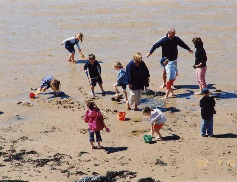
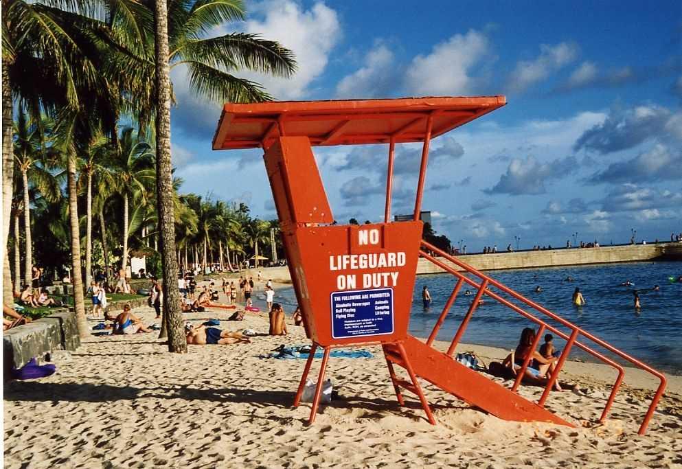
4 Motivation; Coral reef and carbonate beach attract many tourists for instance, six million people in Okinawa. However, drowning accidents by a strong offshore current happen every year. SOMEBODY has to study and minimize the RISK.
5 The project on Reef Rip Current (the strong offshore current in a coral reef); Part 1. Drowning accident data analysis (risk analysis) Part 2. Field study of current, waves. and topography (will be presented at this symposium).
6 Risks in carbonate beach utilization 1 Drowning accidents (number of persons) Record of casualties ( ) Tokyo Coral reef areas Okinawa Kagoshima Prefecture reference Fig. 1 Record on the number of drowning accidents in Japan from 1990 to 2004 (Nishi et al., 2007). Coral reef coasts are in Okinawa, Kagoshima (partially), and Tokyo(partially). Annual drowning accidents (persons/year) Record of drowning accidents in Okinawa Prefecture ( ) Swimming Snorkeling Boat sailing Surfing Diving Marine related activities Fig. 2 Record on the number of drowning accidents in Okinawa based on marine related activities from 1998 to 2006 (Nishi et al., 2007)


 drowned.")

7 Two sisters, 12 and 5 years old, drowned on Tomori beach, Kagoshima 2:50 pm. A man tried to rescue them said that it was like a river. 8 years ago, medical doctor 28 years old drowned. Risks in carbonate beach utilization 2 Three high school students (18 years old) drowned. One was injured, one was dead and one was missing at Nishihama beach, Okinawa during school excursion. Two years ago, a 20-year old university student drowned. Three years ago, a 30-year old man drowned.
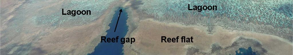
8 Technical questions by rescue agent and beach users on reef rip currents; Where and when, then how strong? Scientific questions by researchers; What is a mechanism and can be predictable? Where is a reef rip current generated? Where is the area that beach user should avoid his/her use. Solution Inspection of aerial photographs; A few thousands aerial photographs supported by the Department of Civil Engineering, Okinawa Prefecture and Japan Geological Survey, were inspected to identify gaps in the reefs.


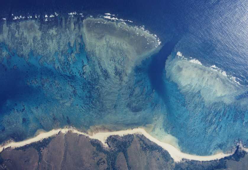
9 Solution for where; reef gap Examples of reef gap
10 Objectives of field study (mechanism and public awareness) 1. To characterize nearshore hydrodynamics in coral reefs through field measurement 2. Then establish the geomorphology-wave-tide current relationship 3. Apply the result to educate rescue agents (how to find reef rip currents and how to act.). 4. Apply the results to public education on safe utilization of beaches (how to minimize risk).


11 Field study in carbonate beach and coral reef system have been conducted since 2005 in Kagoshima and Okinawa, Japan to reveal the strong offshore current mechanisms and reduce drowning accidents. (Where, when, and how strong)
 an 20")

. Field study on Reef Rip Current.")
12 1. Tomori beach, Kagoshima Prefecture in 2004 (pre-project) an Yoshiwara beach, Okinawa Prefecture in 2004 (pre-project), 2005 (summer season) and 2006 (winter season). Field study on Reef Rip Current. Japan Warm Kuroshio Current -> coral reef Kagoshima Okinawa Tomori beach Yoshiwara beach

 study, flow visualization by drogue and dye")

13 FIELD OBSRVATION: The entire project includes bathymetry survey by laser and aerial photographs, nearshore hydrodynamics (wave, current, mean water level, tide and temperature) study, flow visualization by drogue and dye experiment, wind observation, numerical simulation of downward current, public awareness program, and internet access. Internet access was available


14 Study area:yoshiwara coast, Ishigakijima,Okinawa, Japan

15 Laser survey was conducted by JCG Offshore Reef flat Reef flat Carbonate beach Onshore River Bathymetry of the study area (Yoshiwara coast, Okinawa, Japan)
16 0 Transect line (No.1) Transect line (No.2) Height ( m ) Transect line (No.1) Transect line (No.2) Offshore distance ( m ) reef gap well developed reef Cross-shore profiles in a reef gap and well-developed reef
17 Wave Hunter (water level, wave height, current and direction, water temp.) ECM (current direction, water temp.) Water level gage (level, water temp.) Monitor camera N 6m depth Location of wave gage, electronic current meters, tidal gages, monitoring camera (i.e. Winter, 2007)


18 Speed up Flow visualization (dye pattern shows an offshore current toward a reef gap)
19 1200 Offshore distance ( m ) Staff with GPS Float 1 Float 2 Float 3 Float 4 Float 5 Shoreline (L.W.L) Sand beach Staff Reef flat edge (schematic) N 0 Shoreline(H.W.L.) Longshore distance ( m ) Flow visualization (GPS floats were transported into a reef gap)
20 7 Offshore velocity (m/s) O rig in a l d a ta (1 s e c. in te rv a l) 1 0 s e c. m o v in g a v e ra g e ( m / s ) E lla p s e d tim e (s e c.) Example of offshore velocity of GPS drogue around a reef gap.
21 平均水位 (m) Current velocity (m/s) 計測時間 ( 時間 ) 平均水位 W H B Zoom-up Offshore High speed reef rip current develops nearly once in a day at low-low tide in calm waves and weak wind. Offshore Offshore Onshore Average current velocity (WHB) Offshore Offshore Onshore Onshore Elapsed time (hours) Onshore Offshore Onshore 20-min mean current velocity during normal condition(small wave and wind) (June 25 July 1, 2006)
22 High speed reef rip current develops nearly once in a day at low-low tide in calm waves and weak wind. 1.2 Current velocity(m/s) Low tide WHB High tide Water level(m)


23 Why does a high speed reef rip current develop at low tide? Orientation of water level gages (Gage 16 at the reef gap, Gage 26 on the carbonate beach, Gage 25 in the reef lagoon, and Gage 24 on the reef edge)
24 Spatial gradient of mean water level caused by tide v 2gh m/ s? Mean water level outside of coral reef (No. 16), on reef edge (No. 24), in the middle of the lagoon (No. 25), in front of the carbonate beach (No. 26)


25 Reef flat (reef edge) and lagoon system contains mass of water similar to a hydraulic dam on the other hand, a reef gap where the elevation is lower has a function to discharge water in the lagoon during low tide. v 2gh m/ s?
26 High speed reef rip current develops not only at low tide, but also under high waves and onshore strong wind (typically winter in the study area). 20 minutes average velocity(m/s) (-); Onshore (-); Onshore (+); Offshore (+); Offshore N-S component(m/s) E-W component(m/s) Ellapsed time (day) 20-min mean current velocity during winter season 2007(high waves and strong wind).
27 High speed reef rip current develops not only at low tide, but also under high waves and strong onshore wind. 20 minutes average vel.(m/s) & Tidal level(m) m inute average velocity(m/s) Tidal level(m) E lapsed tim e(day) Tide and velocity record in winter season 2007
28 High speed reef rip current; strong enough on the sea bed (hard coral bottom) in winter condition second 20 秒平均流速 average velocity (cm/s) (cm/s) Velociyty 10cm above sea bed Ellapsed time (day)
29 Q; When does a high-speed reef rip current develop? Current velocity (m/s) E l a p s e d t i m e ( h o u r s ) A v e r a g e c u r r e n t v e l o c i t y ( W H B ) 20 minutes average vel.(m/s) & Tidal level(m) m i n u t e a v e r a g e v e l o c i t y ( m / s ) T i d a l l e v e l ( m ) E l a p s e d t i m e ( d a y ) A; (1)Low tide under calm waves; (2) high waves; and (3) strong onshore wind.
30 How strong is a reef rip current? 20 minutes average vel.(m/s) & Tidal level(m) Not for official use! 20 minute average velocity(m/s) Tidal level(m) Extreme danger Strong danger Danger Elapsed time(day) Swimming speed Safe student Current No one can swim against a high-speed reef rip current!
31 CONCLUSION: The study has revealed that; (i) The maximum 20-min average offshore velocity could be order of 2 m/s especially during winter season, because the northern wind that is perpendicular to the coast is persistent and generates reasonably high waves; (ii) A reef flat and lagoon system has a function to contain mass of water similar to a hydraulic dam or a reservoir; on the other hand, a reef gap where the elevation is lower and reef width is narrower has a function to discharge water in the lagoon.
32 CONCLUSION: The study has revealed that (ii) The mass of the water contained in the lagoon is dependent on tide, waves, and wind.
33 The authors would like to express their special appreciation to whom assist the project nevertheless a risky sea condition and hope the project improve the safe utilization of coral reef and carbonate beach.


34 Sorry, I am going home! Q & Answer ; (tough question; send an to Nishi Sediment_24@hotmail.com)
35
36 0 Transect line (No.1) Transect line (No.2) Height ( m ) Transect line (No.1) Transect line (No.2) Offshore distance ( m )
37 Grid system for a down current simulation Wall (Slip condition) Flow 0 10 Outflow Boundary Z ( m ) 20 Wall (Non-slip condition) X ( m )
38 High tide condition u=1, 2, 3m/s 0 Z ( m ) 10 3m/s 2m/s 1m/s (m/s) X ( m ) 0 Z ( m ) 10 3m/s 2m/s 1m/s (m/s) X ( m )
 0 Z ( m ) 10 3m/s 2m/s 1m/s 20 0 1 2 3 (m/s) 0 50 100 150 X ( m )")
39 Low tide condition U=1, 2, 3m/s 0 Z ( m ) 10 3m/s 2m/s 1m/s (m/s) X ( m ) 0 Z ( m ) 10 3m/s 2m/s 1m/s (m/s) X ( m )
Wind Blow-out Hollow Generated in Fukiage Dune Field, Kagoshima Prefecture, Japan
 R. Nishi Wind Blow-out Hollow Generated in Fukiage Dune Field, Kagoshima Prefecture, Japan Ryuichiro Nishi, Li Elikson and Myokhin PREFACE A sand dune is vulnerable to severe waves and wind. Therefore,
EROSION MECHANICS OF A CARBONATE- TOMBOLO BEACH IN MIYAKOJIMA ISLAND, OKINAWA PREFECTURE, JAPAN.
 EROSION MECHANICS OF A CARBONATE- TOMBOLO BEACH IN MIYAKOJIMA ISLAND, OKINAWA PREFECTURE, JAPAN. Ryuichiro NISHI 1, Takaaki UDA 2, Akio KIKUCHI 3 and Kou FURUIKE 4 1) Associate Prof. Dept. of Ocean Civil
Physical Modeling of Nearshore Placed Dredged Material Rusty Permenter, Ernie Smith, Michael C. Mohr, Shanon Chader
 Physical Modeling of Nearshore Placed Dredged Material Rusty Permenter, Ernie Smith, Michael C. Mohr, Shanon Chader Research Hydraulic Engineer ERDC-Coastal Hydraulics Laboratory October 25,2012 Study
Undertow - Zonation of Flow in Broken Wave Bores
 Nearshore Circulation Undertow and Rip Cells Undertow - Zonation of Flow in Broken Wave Bores In the wave breaking process, the landward transfer of water, associated with bore and surface roller decay
New Jersey Coastal Zone Overview. The New Jersey Beach Profile Network (NJBPN) 3 Dimensional Assessments. Quantifying Shoreline Migration
 3 Dimensional Assessments. Quantifying Shoreline Migration") New Jersey Coastal Zone Overview The New Jersey Beach Profile Network (NJBPN) Objectives Profile Locations Data Collection Analyzing NJBPN Data Examples 3 Dimensional Assessments Methodology Examples Quantifying
New Jersey Coastal Zone Overview The New Jersey Beach Profile Network (NJBPN) Objectives Profile Locations Data Collection Analyzing NJBPN Data Examples 3 Dimensional Assessments Methodology Examples Quantifying
G. Meadows, H. Purcell and L. Meadows University of Michigan
 www.coj.net/departments/fire+and+rescue/emergency+preparedness/rip+current.htm G. Meadows, H. Purcell and L. Meadows Over 80% of all surf related rescues are attributable to Rip Currents According to the
Undertow - Zonation of Flow in Broken Wave Bores
 Lecture 22 Nearshore Circulation Undertow - Zonation of Flow in Broken Wave Bores In the wave breaking process, the landward transfer of water, associated with bore and surface roller decay within the
ABSTRACT. KEY WORDS: coral reef, storm waves, infragravity waves, power plant, cooling water, field observation. INTRODUCTION FIELD OBSERVATION
 M.W.L. Fluctuations Inside a Cooling Water Tank Set Inside a Coral Reef Julio Monroy Department of Civil Engineering, Kagoshima University -2-4 Korimoto, Kagoshima-shi, Japan 89-65 Ryuchiro Nishi, Michio
CROSS-SHORE SEDIMENT PROCESSES
 The University of the West Indies Organization of American States PROFESSIONAL DEVELOPMENT PROGRAMME: COASTAL INFRASTRUCTURE DESIGN, CONSTRUCTION AND MAINTENANCE A COURSE IN COASTAL DEFENSE SYSTEMS I CHAPTER
Volume and Shoreline Changes along Pinellas County Beaches during Tropical Storm Debby
 Volume and Shoreline Changes along Pinellas County Beaches during Tropical Storm Debby Ping Wang and Tiffany M. Roberts Coastal Research Laboratory University of South Florida July 24, 2012 Introduction
There are many different kinds of beaches which are generally characterized by the dominance of waves, tides, rivers and currents, and in particular
 Fig. 11-11, p. 253 There are many different kinds of beaches which are generally characterized by the dominance of waves, tides, rivers and currents, and in particular differ by the amount of energy, which
STUDY ON TSUNAMI PROPAGATION INTO RIVERS
 ABSTRACT STUDY ON TSUNAMI PROPAGATION INTO RIVERS Min Roh 1, Xuan Tinh Nguyen 2, Hitoshi Tanaka 3 When tsunami wave propagation from the narrow river mouth, water surface is raised and fluctuated by long
MULTIDECADAL SHORELINE EVOLUTION DUE TO LARGE-SCALE BEACH NOURISHMENT JAPANESE SAND ENGINE? Abstract
 MULTIDECADAL SHORELINE EVOLUTION DUE TO LARGE-SCALE BEACH NOURISHMENT JAPANESE SAND ENGINE? Masayuki Banno 1, Satoshi Takewaka 2 and Yoshiaki Kuriyama 3 Abstract Beach nourishment is one of the countermeasures
A process based approach to understand WA s complex coastline Jeff Hansen Ryan Lowe Graham Symonds Laura Segura Gundula Winter
 A process based approach to understand WA s complex coastline Jeff Hansen Ryan Lowe Graham Symonds Laura Segura Gundula Winter WA s coastline is highly variable due to offshore and shore-attached coral
Coastal Sediment Transport Modeling Ocean Beach & San Francisco Bight, CA
 1 Coastal Sediment Transport Modeling Ocean Beach & San Francisco Bight, CA Honghai Li and Lihwa Lin Engineering Research and Development Center U.S. Army Corps of Engineers Frank Wu, Lisa Andes, and James
Low-crested offshore breakwaters: a functional tool for beach management
 Environmental Problems in Coastal Regions VI 237 Low-crested offshore breakwaters: a functional tool for beach management K. Spyropoulos & E. Andrianis TRITON Consulting Engineers, Greece Abstract Beach
RIP CURRENTS. Award # N
 RIP CURRENTS Graham Symonds School of Geography and Oceanography University College, University of New South Wales, Australian Defence Force Academy, Canberra, 2600 AUSTRALIA Phone: 61-6-2688289 Fax: 61-6-2688313
Predicting wave conditions in a coral embayment from offshore directional spectral model input
 Predicting wave conditions in a coral embayment from offshore directional spectral model input Ron Hoeke 1,2 and Curt Storlazzi 3 1 Coral Reef Ecosystem Division (CRED) NOAA Pacific Islands Fisheries Science
Prediction of Nearshore Waves and Currents: Model Sensitivity, Confidence and Assimilation
 Prediction of Nearshore Waves and Currents: Model Sensitivity, Confidence and Assimilation H. Tuba Özkan-Haller College of Oceanic and Atmospheric Sciences Oregon State University, 104 Ocean Admin Bldg
A Preliminary Review of Beach Profile and Hardbottom Interactions
 A Preliminary Review of Beach Profile and Hardbottom Interactions Douglas W. Mann, P.E., D.CE. CB&I A World of Solutions Presentation Goal Lead to a better understanding of the challenges regarding the
PHYSICAL REQUIREMENTS FOR A TAKEOFF IN SURFING. Akihiko Kimura 1 and Taro Kakinuma 2
 PHYSICAL REQUIREMENTS FOR A TAKEOFF IN SURFING Akihiko Kimura 1 and Taro Kakinuma 2 The conditions required for a takeoff in surfing, are discussed, with the waves simulated numerically, considering two
Hydrologic Feasibility of Storm Surge Barriers
 Hydrologic Feasibility of Storm Surge Barriers Malcolm J. Bowman, School of Marine and Atmospheric Sciences State University of New York, Stony Brook, NY. Presented at Against the Deluge: Storm Surge Barriers
Lee E. Harris, Ph.D., P.E. Assoc. Professor of Ocean Engineering. Doug Bowlus and Ashley Naimaster Ocean Engineering Graduate Students
 FLORIDA TECH OCEAN ENGINEERING PROFESSOR LEE HARRIS AND HIS GRADUATE STUDENTS ASSIST WITH POST-HURRICANE IVAN CORAL REEF RESTORATION IN THE CAYMAN ISLANDS Lee E. Harris, Ph.D., P.E. Assoc. Professor of
Ryuichiro Nishi, Li Erikson and MyoKhin Kagoshima Univ., Lund Univ., Daiichi Institute of Technology
 Dune blowout hollow generated in Fukiage Dune, Kagoshima, Japan Ryuichiro Nishi, Li Erikson and MyoKhin Kagoshima Univ., Lund Univ., Daiichi Institute of Technology Contents of this presentation; topography
Beach Profiles. Topics. Module 9b Beach Profiles and Crossshore Sediment Transport 3/23/2016. CE A676 Coastal Engineering
 Beach Profiles AND CROSS-SHORE TRANSPORT Orson P. Smith, PE, Ph.D., Professor Emeritus Topics Features of beach and nearshore profiles Equilibrium profiles Cross-shore transport References Text (Sorensen)
LOCALLY CONCENTRATED SEVERE BEACH EROSION ON SEISHO COAST CAUSED BY TYPHOON T0709
 F-4 Fourth International Conference on Scour and Erosion 2008 LOCALLY CONCENTRATED SEVERE BEACH EROSION ON SEISHO COAST CAUSED BY TYPHOON T0709 Yoshimitsu TAJIMA 1 and Shinji SATO 2 1 Member of JSCE, Associate
Improving predictions of nearshore processes and shoreline dynamics for beaches along Australia s rocky and coral reef coasts
 Improving predictions of nearshore processes and shoreline dynamics for beaches along Australia s rocky and coral reef coasts Ryan Lowe Jeff Hansen, Graham Symonds, Mark Buckley, Andrew Pomeroy, Gundula
CHAPTER 134 INTRODUCTION
 CHAPTER 134 NEW JETTIES FOR TUNG-KANG FISHING HARBOR, TAIWAN Chi-Fu Su Manager Engineering Department Taiwan Fisheries Consultants, Inc. Taipei, Taiwan INTRODUCTION Tung-Kang Fishing Harbor, which is about
IMAGE-BASED FIELD OBSERVATION OF INFRAGRAVITY WAVES ALONG THE SWASH ZONE. Yoshimitsu Tajima 1
 IMAGE-BASED FIELD OBSERVATION OF INFRAGRAVITY WAVES ALONG THE SWASH ZONE Yoshimitsu Tajima 1 This study develops an image-based monitoring techniques for observations of surf zone hydrodynamics especially
BEACH NOURISHMENT PROJECTS IN CARBONATE MATERIAL BEACH
 Submitted February, 2006 BEACH NOURISHMENT PROJECTS IN CARBONATE MATERIAL BEACH Ryuichiro Nishi 1, Robert G. Dean 2 and Mario P. de Leon 1 1 Department of Ocean Civil Engineering, Kagoshima University,
LAB: WHERE S THE BEACH
 Name: LAB: WHERE S THE BEACH Introduction When you build a sandcastle on the beach, you don't expect it to last forever. You spread out your towel to sunbathe, but you know you can't stay in the same spot
Nearshore Sediment Transport What influences the loss of sediment on Beaches? - Waves - Winds - Tidal Currents - River discharge - Runoff
 Tides & Beaches Nearshore Sediment Transport What influences the loss of sediment on Beaches? - Waves - Winds - Tidal Currents - River discharge - Runoff Oceans Ocean Topography Physical Structure of the
COASTAL MORPHODYNAMICS
 COASTAL MORPHODYNAMICS PATRICIA CHARDÓN-MALDONADO, PHD, EIT Miguel Canals, Jack A. Puleo, Alec Torres-Freyermuth & Jens Figlus March 9, 2017 OUTLINE INTRODUCTION Meteorological Phenomena Forcing Conditions
Figure 1, Chart showing the location of the Breach at Old Inlet and sensors deployed in Great South Bay.
 The Impact on Great South Bay of the Breach at Old Inlet Charles N. Flagg and Roger Flood School of Marine and Atmospheric Sciences, Stony Brook University The Great South Bay project (http://po.msrc.sunysb.edu/gsb/)
Taranaki Tsunami Inundation Analysis. Prepared for Taranaki Civil Defence Emergency Management Group. Final Version
 Taranaki Tsunami Inundation Analysis Prepared for Taranaki Civil Defence Emergency Management Group Final Version June 2012 AM 12/07 HBRC Plan Number 4362 Asset Management Group Technical Report Prepared
SHORELINE ROTATION CAUSED BY LARGE-SCALE EXCAVATION OF REEF FLAT ON SANUR BEACH IN BALI
 SHORELINE ROTATION CAUSED BY LARGE-SCALE EXCAVATION OF REEF FLAT ON SANUR BEACH IN BALI Masatoshi Endo, Akio Kobayashi, Takaaki Uda, Yasuhito Noshi and Susumu Onaka In the southern part of Sanur Beach
SAN DIEGUITO WETLANDS RESTORATION PROJECT 08 JANUARY 2018 BEACH PROFILES CITY OF DEL MAR, CALIFORNIA. Data Report
 SAN DIEGUITO WETLANDS RESTORATION PROJECT 08 JANUARY 2018 BEACH PROFILES CITY OF DEL MAR, CALIFORNIA Data Report Prepared by Coastal Environments, Inc. 2166 Avenida de la Playa, Suite E La Jolla, CA 92037
CHAPTER 8 ASSESSMENT OF COASTAL VULNERABILITY INDEX
 124 CHAPTER 8 ASSESSMENT OF COASTAL VULNERABILITY INDEX 8.1 INTRODUCTION In order to assess the vulnerability of the shoreline considered under this study against the changing environmental conditions,
CHANGE IN CARBONATE BEACH TRIGGERED BY CONSTRUCTION OF A BRIDGE ON IRABU ISLAND AND ITS SIMULATION USING BG MODEL
 Proceedings of the 7 th International Conference on Asian and Pacific Coasts (APAC 2013) Bali, Indonesia, September 24-26, 2013 CHANGE IN CARBONATE BEACH TRIGGERED BY CONSTRUCTION OF A BRIDGE ON IRABU
Assateague Island National Seashore North End Restoration Project Timeline
 Assateague Island National Seashore North End Restoration Project Timeline Date Event Some information provided in the Project Introduction document. Detailed events are available in a timeline compiled
Lecture Outlines PowerPoint. Chapter 15 Earth Science, 12e Tarbuck/Lutgens
 Lecture Outlines PowerPoint Chapter 15 Earth Science, 12e Tarbuck/Lutgens 2009 Pearson Prentice Hall This work is protected by United States copyright laws and is provided solely for the use of instructors
HURRICANE SANDY LIMITED REEVALUATION REPORT UNION BEACH, NEW JERSEY DRAFT ENGINEERING APPENDIX SUB APPENDIX D SBEACH MODELING
 HURRICANE SANDY LIMITED REEVALUATION REPORT UNION BEACH, NEW JERSEY DRAFT ENGINEERING APPENDIX SUB APPENDIX D SBEACH MODELING Rev. 18 Feb 2015 1 SBEACH Modeling 1.0 Introduction Following the methodology
UPPER BEACH REPLENISHMENT PROJECT RELATED
 ASSESSMENT OF SAND VOLUME LOSS at the TOWNSHIP of UPPER BEACH REPLENISHMENT PROJECT RELATED to the LANDFALL OF HURRICANE SANDY - PURSUANT TO NJ-DR 4086 This assessment is in response to Hurricane Sandy
MONITORING SEDIMENT TRANSPORT PROCESSES AT MANAVGAT RIVER MOUTH, ANTALYA TURKEY
 COPEDEC VI, 2003 in Colombo, Sri Lanka MONITORING SEDIMENT TRANSPORT PROCESSES AT MANAVGAT RIVER MOUTH, ANTALYA TURKEY Isikhan GULER 1, Aysen ERGIN 2, Ahmet Cevdet YALCINER 3 ABSTRACT Manavgat River, where
Marginal Marine Environments
 Marginal Marine Environments Delta: discrete shoreline protuberances formed where rivers enter oceans, semi-enclosed seas, lakes or lagoons and supply sediment more rapidly than it can be redistributed
Oceans and Coasts. Chapter 18
 Oceans and Coasts Chapter 18 Exploring the oceans The ocean floor Sediments thicken and the age of the seafloor increases from ridge to shore The continental shelf off the northeast United States Constituent
Chapter 10 Lecture Outline. The Restless Oceans
 Chapter 10 Lecture Outline The Restless Oceans Focus Question 10.1 How does the Coriolis effect influence ocean currents? The Ocean s Surface Circulation Ocean currents Masses of water that flow from one
Overview. Beach Features. Coastal Regions. Other Beach Profile Features. CHAPTER 10 The Coast: Beaches and Shoreline Processes.
 Overview CHAPTER 10 The Coast: Beaches and Shoreline Processes Coastal regions constantly change. The beach is a dominant coastal feature. Wave activity continually modifies the beach and coastal areas.
General Information on Drowning
 General Information on Drowning Drowning is the third leading cause of accidental death in the United States and the second leading cause of accidental death for persons aged 5 to 44. For children in the
PREDICTION OF BEACH CHANGES AROUND ARTIFICIAL REEF USING BG MODEL
 PREDICTION OF BEACH CHANGES AROUND ARTIFICIAL REEF USING BG MODEL Hiroaki Fujiwara 1, Takaaki Uda 2, Toshiaki Onishi 1, Shiho Miyahara 3 and Masumi Serizawa 3 On the Kaike coast, one of the twelve detached
SAND BOTTOM EROSION AND CHANGES OF AN ACTIVE LAYER THICKNESS IN THE SURF ZONE OF THE NORDERNEY ISLAND
 SAND BOTTOM EROSION AND CHANGES OF AN ACTIVE LAYER THICKNESS IN THE SURF ZONE OF THE NORDERNEY ISLAND Kos'yan R. 1, Kunz H. 2, Podymov l. 3 1 Prof.Dr.,The Southern Branch of the P.P.Shirshov Institute
The Case of the Disappearing Shoreline
 Name The Case of the Disappearing Shoreline Humans change the earth's climate in many ways. One change is the increase of carbon dioxide in the atmosphere. As we burn more fossil fuels, we release more
Water circulation in a fringing reef located in a monsoon area: Kabira Reef, Ishigaki Island, Southwest Japan
 Coral Reefs (1998) 17 :89 99 Springer-Verlag 1998 REPORT H. Yamano H. Kayanne N. Yonekura H. Nakamura K. Kudo Water circulation in a fringing reef located in a monsoon area: Kabira Reef, Ishigaki Island,
Inlet Management Study for Pass-A-Grille and Bunces Pass, Pinellas County, Florida
 Inlet Management Study for Pass-A-Grille and Bunces Pass, Pinellas County, Florida Final Report Submitted By Ping Wang, Ph.D., Jun Cheng Ph.D., Zachary Westfall, and Mathieu Vallee Coastal Research Laboratory
Investigations and Recommendations for Solutions to the Beach Erosion Problems in the City of Herzliya, Israel
 Investigations and Recommendations for Solutions to the Beach Erosion Problems in the City of Herzliya, Israel Site Inspection Performed 30 April to 6 May 2007 Prepared for: City of Herzliya Office of
Follets Island Nearshore Beach Nourishment Project
 Coast & Harbor Engineering A division of Hatch Mott MacDonald Follets Island Nearshore Beach Nourishment Project Arpit Agarwal, P.E. April 1, 2016 Project Site!"#$% &'(% &)*+% )#,'-+% Shoreline Erosion
LITTLE LAGOON & LITTLE LAGOON PASS: RESEARCH UPDATES & DIRECTIONS
 LITTLE LAGOON & LITTLE LAGOON PASS: RESEARCH UPDATES & DIRECTIONS Bret M. Webb, PhD, PE, DCE Professor Department of Civil, Coastal, and Environmental Engineering October 19, 2017 LLPS Meeting Acknowledgments
Chapter 11. Beach Fill and Soft Engineering Structures
 Chapter 11 Beach Fill and Soft Engineering Structures Solutions to Coastal Erosion Soft Structures Hard Structures Retreat No such thing as low cost coastal protection Beach Nourishment Beach Filling Beach
Figure 4, Photo mosaic taken on February 14 about an hour before sunset near low tide.
 The Impact on Great South Bay of the Breach at Old Inlet Charles N. Flagg and Roger Flood School of Marine and Atmospheric Sciences, Stony Brook University Since the last report was issued on January 31
Nearshore Placed Mound Physical Model Experiment
 Nearshore Placed Mound Physical Model Experiment PURPOSE: This technical note describes the migration and dispersion of a nearshore mound subjected to waves in a physical model. The summary includes recommendations
Kelly Legault, Ph.D., P.E. USACE SAJ
 Kelly Legault, Ph.D., P.E. USACE SAJ Report Documentation Page Form Approved OMB No. 0704-0188 Public reporting burden for the collection of information is estimated to average 1 hour per response, including
HYDRODYNAMICS AND MORPHODYNAMICS IN THE SURF ZONE OF A DISSIPATIVE BEACH
 HYDRODYNAMICS AND MORPHODYNAMICS IN THE SURF ZONE OF A DISSIPATIVE BEACH Leo C. van Rijn, Dirk Jan R. Walstra, Bart T. Grasmeijer and Kees Kleinhout Abstract: Two profile models have been compared with
Appendix E Cat Island Borrow Area Analysis
 Appendix E Cat Island Borrow Area Analysis ERDC/CHL Letter Report 1 Cat Island Borrow Area Analysis Multiple borrow area configurations were considered for Cat Island restoration. Borrow area CI1 is located
Available online at ScienceDirect. Procedia Engineering 116 (2015 )
") Available online at www.sciencedirect.com ScienceDirect Procedia Engineering 116 (2015 ) 320 325 8th International Conference on Asian and Pacific Coasts (APAC 2015) Department of Ocean Engineering, IIT
Available online at www.sciencedirect.com ScienceDirect Procedia Engineering 116 (2015 ) 320 325 8th International Conference on Asian and Pacific Coasts (APAC 2015) Department of Ocean Engineering, IIT
Rip Current Rip Tide,
 Rip Current A Rip Current, sometimes called a Rip Tide, is one specific kind of water current that can be found near beaches. It is a strong, localized, narrow current of water. It is strongest near the
The role of the inter-bar depressions in hydrodynamic and sediment transport processes of sandy macrotidal beaches
 The role of the inter-bar depressions in hydrodynamic and sediment transport processes of sandy macrotidal beaches Adrien CARTIER 1,2, Arnaud HÉQUETTE 1,2 and Philippe LARROUDE 3 1. Laboratoire d Océanologie
OECS Regional Engineering Workshop September 29 October 3, 2014
 B E A C H E S. M A R I N A S. D E S I G N. C O N S T R U C T I O N. OECS Regional Engineering Workshop September 29 October 3, 2014 Coastal Erosion and Sea Defense: Introduction to Coastal Dynamics David
COLLAPSE MECHANISM OF SEAWALLS BY IMPULSIVE LOAD DUE TO THE MARCH 11 TSUNAMI
 9 th International Conference on Shock & Impact Loads on Structures Fukuoka, Japan, Nov. 16-18, 2011 COLLAPSE MECHANISM OF SEAWALLS BY IMPULSIVE LOAD DUE TO THE MARCH 11 TSUNAMI N. Ishikawa *, M. Beppu**,
Beach Wizard: Development of an Operational Nowcast, Short-Term Forecast System for Nearshore Hydrodynamics and Bathymetric Evolution
 Beach Wizard: Development of an Operational Nowcast, Short-Term Forecast System for Nearshore Hydrodynamics and Bathymetric Evolution Ad Reniers Civil Engineering and Geosciences, Delft University of Technology
Hydrographic Surveying Methods, Applications and Uses
 Definition: Hydrographic Surveying Methods, Applications and Uses It is the branch of surveying which deals with any body of still or running water such as a lake, harbor, stream or river. Hydrographic
MESSOLOGI LAGOON AREA (GREECE)
") MESSOLOGI LAGOON AREA (GREECE) 20 Contact: Kyriakos SPYROPOULOS TRITON Consulting Engineers 90 Pratinou Str. 11634 Athens (GREECE) Tel: +32 10 729 57 61 Fax: +32 10 724 33 58 e-mail: kspyropoulos@tritonsa.gr
MESSOLOGI LAGOON AREA (GREECE) 20 Contact: Kyriakos SPYROPOULOS TRITON Consulting Engineers 90 Pratinou Str. 11634 Athens (GREECE) Tel: +32 10 729 57 61 Fax: +32 10 724 33 58 e-mail: kspyropoulos@tritonsa.gr
A STUDY ON TYPHOONS INDUCED NEARSHORE HYDRODYNAMICS ALONG KINMEN COAST
 A STUDY ON TYPHOONS INDUCED NEARSHORE HYDRODYNAMICS ALONG KINMEN COAST Wen-Son Chiang 1 Wei-Shiun Lu 2 Gia-Yun Chen 3 and Jin-Li Yu 1 Coastal erosion along Liaolo Bay which is a semi-circular beach and
CHAPTER 179. Performance of a Submerged Breakwater for Shore Protection
 CHAPTER 179 Abstract Performance of a Submerged Breakwater for Shore Protection Albert E. Browder',A. Member, ASCE; Robert G. Dean 2, Member, ASCE; and Renjie Chen 3 A summary is presented of the results
Quantitative Freshwater Mussel Survey Date Prepared: 11/20/2017
 PARTNERSHIP FOR THE DELAWARE ESTUARY Science Group Quantitative Freshwater Mussel Survey Date Prepared: 11/20/2017 Prepared By: Kurt Cheng Suggested Citation: Cheng, K. 2017. Quantitative Freshwater Mussel
MIAMI BEACH 32ND STREET HOT SPOT: NUMERICAL MODELING AND DESIGN OPTIMIZATION. Adam Shah - Coastal Engineer Harvey Sasso P.E.
 ABSTRACT MIAMI BEACH 32ND STREET HOT SPOT: NUMERICAL MODELING AND DESIGN OPTIMIZATION Adam Shah - Coastal Engineer Harvey Sasso P.E. - Principal Coastal Systems International, Inc. 464 South Dixie Highway
DUXBURY WAVE MODELING STUDY
 DUXBURY WAVE MODELING STUDY 2008 Status Report Duncan M. FitzGerald Peter S. Rosen Boston University Northeaster University Boston, MA 02215 Boston, MA 02115 Submitted to: DUXBURY BEACH RESERVATION November
Wave Breaking and Wave Setup of Artificial Reef with Inclined Crown Keisuke Murakami 1 and Daisuke Maki 2
 Wave Breaking and Wave Setup of Artificial Reef with Inclined Crown Keisuke Murakami 1 and Daisuke Maki 2 Beach protection facilities are sometimes required to harmonize with coastal environments and utilizations.
PROPAGATION OF LONG-PERIOD WAVES INTO AN ESTUARY THROUGH A NARROW INLET
 PROPAGATION OF LONG-PERIOD WAVES INTO AN ESTUARY THROUGH A NARROW INLET Takumi Okabe, Shin-ichi Aoki and Shigeru Kato Department of Civil Engineering Toyohashi University of Technology Toyohashi, Aichi,
Unsteady Wave-Driven Circulation Cells Relevant to Rip Currents and Coastal Engineering
 Unsteady Wave-Driven Circulation Cells Relevant to Rip Currents and Coastal Engineering Andrew Kennedy Dept of Civil and Coastal Engineering 365 Weil Hall University of Florida Gainesville, FL 32611 phone:
Beach Nourishment Impact on Beach Safety and Surfing in the North Reach of Brevard County, Florida
 Beach Nourishment Impact on Beach Safety and Surfing in the North Reach of Brevard County, Florida Prepared by John Hearin, Ph.D. Coastal Engineering Vice Chairman Cocoa Beach Chapter Port Canaveral Patrick
Modeling Sediment Transport Along the Upper Texas Coast
 Modeling Sediment Transport Along the Upper Texas Coast David B. King Jr. Jeffery P. Waters William R. Curtis Highway 87 roadbed, Jefferson County Galveston District Corps Sabine Pass to San Luis Pass
INTRODUCTION TO COASTAL ENGINEERING
 The University of the West Indies Organization of American States PROFESSIONAL DEVELOPMENT PROGRAMME: COASTAL INFRASTRUCTURE DESIGN, CONSTRUCTION AND MAINTENANCE A COURSE IN COASTAL DEFENSE SYSTEMS I CHAPTER
Lagrangian Tracer Transport and Dispersion in Shallow Tidal Inlets & River Mouths
 DISTRIBUTION STATEMENT A: Approved for public release; distribution is unlimited. Lagrangian Tracer Transport and Dispersion in Shallow Tidal Inlets & River Mouths R. T. Guza & Falk Feddersen Scripps Institution
Variation in Beach Profile and Sediment Characteristics at Popham Beach, Phippsburg, ME
 Colby College Digital Commons @ Colby Undergraduate Research Symposium Student Research 2006 Variation in Beach Profile and Sediment Characteristics at Popham Beach, Phippsburg, ME Kathryn Lidington Colby
WAVE BREAKING AND DISSIPATION IN THE NEARSHORE
 WAVE BREAKING AND DISSIPATION IN THE NEARSHORE LONG-TERM GOALS Dr. Thomas C. Lippmann Center for Coastal Studies Scripps Institution of Oceanography University of California, San Diego 9500 Gilman Dr.
Chapter - Oceans and Coasts
 Chapter - Oceans and Coasts Discussion: What do oceans contribute to the environment of Earth? How do Earth s major systems relate to the oceans? Oceans and Coasts Oceans are important - Thermal regulation
Reading Material. Inshore oceanography, Anikouchine and Sternberg The World Ocean, Prentice-Hall
 Reading Material Inshore oceanography, Anikouchine and Sternberg The World Ocean, Prentice-Hall BEACH PROCESSES AND COASTAL ENVIRONMENTS COASTAL FEATURES Cross section Map view Terminology for Coastal
Shoreline Response to an Offshore Wave Screen, Blairgowrie Safe Boat Harbour, Victoria, Australia
 Shoreline Response to an Offshore Wave Screen, Blairgowrie Safe Boat Harbour, Victoria, Australia T.R. Atkins and R. Mocke Maritime Group, Sinclair Knight Merz, P.O. Box H615, Perth 6001, Australia ABSTRACT
Nearshore Dredged Material Placement Pilot Study at Noyo Harbor, CA
 1 Nearshore Dredged Material Placement Pilot Study at Noyo Harbor, CA Noyo Cove N 2011 National Conference on Beach Preservation Technology 9-11, February 2011 Lihwa Lin, Honghai Li, Mitchell Brown US
Essentials of Oceanography Eleventh Edition
 Chapter Chapter 1 10 Clickers Lecture Essentials of Oceanography Eleventh Edition The Coast: Beaches and Shoreline Processes Alan P. Trujillo Harold V. Thurman Chapter Overview Coastal regions have distinct
3.9 FROM ISLANDS TO ATOLLS
 3.9 1 3.9 FROM ISLANDS TO ATOLLS OBJECTIVES The students Listen to a description of the formation of volcanic islands, fringing reefs, barrier reefs, and atolls. Observe and participate in a simulation
Understanding the Tsunami Wave
 The First Tsunami attack on Sri Lanka Krakatoa Island 27 th August 1883 Understanding the Tsunami Wave Generation Propagation Nearshore Transformation Shoreline Entry Inland Dissipation 1 Generation and
Wave Setup at River and Inlet Entrances Due to an Extreme Event
 Proceedings of International Conference on Violent Flows (VF-2007) Organized by RIAM, Kyushu University, Fukuoka, Japan Wave Setup at River and Inlet Entrances Due to an Extreme Event Xuan Tinh Nguyen
LABORATORY EXPERIMENTS ON EROSION CONTROL PERFORMANCE OF AN L- SHAPED PERMEABLE STRUCTURE. Abstract
 LABORATORY EXPERIMENTS ON EROSION CONTROL PERFORMANCE OF AN L- SHAPED PERMEABLE STRUCTURE Yuuji Maeda 1, Masayuki Unno 2, Masafumi Sato 2, Takao Kurita 2, Takaaki Uda 3 and Shinji Sato 4 Abstract A new
IMPACTS OF COASTAL PROTECTION STRATEGIES ON THE COASTS OF CRETE: NUMERICAL EXPERIMENTS
 IMPACTS OF COASTAL PROTECTION STRATEGIES ON THE COASTS OF CRETE: NUMERICAL EXPERIMENTS Tsanis, I.K., Saied, U.M., Valavanis V. Department of Environmental Engineering, Technical University of Crete, Chania,
Wave-dominated embayed beaches. Andrew D Short School of Geosciences University of Sydney
 Wave-dominated embayed beaches Andrew D Short School of Geosciences University of Sydney Wave-dominated embayed beaches wave-dominated beaches embayed beaches morphodynamics of W-D embayed beaches circulation,
Analysis of Wave Predictions from the Coastal Model Test Bed using cbathy
 Analysis of Wave Predictions from the Coastal Model Test Bed using cbathy Spicer Bak, Ty Hesser, Jane Smith U.S. Army Engineer Research & Development Center Duck, NC Coastal Model Test Bed Purpose: Automated
GENERAL METHODOLOGY FOR INLET RESERVOIR MODEL ANALYSIS OF SAND MANAGEMENT NEAR TIDAL INLETS. Mohamed A. Dabees 1, Nicholas C.
 GENERAL METHODOLOGY FOR INLET RESERVOIR MODEL ANALYSIS OF SAND MANAGEMENT NEAR TIDAL INLETS Mohamed A. Dabees 1, Nicholas C. Kraus 2 1 Humiston& Moore Engineers, 5679 Strand Court, Naples, FL 34109, USA.
Nearshore Morphodynamics. Bars and Nearshore Bathymetry. Sediment packages parallel to shore, that store beach sediment
 Nearshore Morphodynamics http://coastal.er.usgs.gov/bier/images/chandeleur-xbeach-lg.jpg Bars and Nearshore Bathymetry Sediment packages parallel to shore, that store beach sediment Can be up to 50 km
ABSTRACT. KEY WORDS: Navigation safety; numerical modeling; waves; current; sediment transport; channel infilling; morphology change.
 The 25th (2015) International Polar and Engineering Conference Li, H., L. Lin, Z. Demirbilek, T. M. Beck, and H. R. Moritz (2015). Wave-Current Conditions and Navigation Safety at an Inlet Entrance. The