GenCade Applications Ashley Frey
|
|
|
- Joel Daniel
- 5 years ago
- Views:
Transcription


1 GenCade Applications Ashley Frey Research Civil Engineer, Co-PI of the Inlet Engineering Toolbox work unit of CIRP
2 Report Documentation Page Form Approved OMB No Public reporting burden for the collection of information is estimated to average 1 hour per response, including the time for reviewing instructions, searching existing data sources, gathering and maintaining the data needed, and completing and reviewing the collection of information. Send comments regarding this burden estimate or any other aspect of this collection of information, including suggestions for reducing this burden, to Washington Headquarters Services, Directorate for Information Operations and Reports, 1215 Jefferson Davis Highway, Suite 1204, Arlington VA Respondents should be aware that notwithstanding any other provision of law, no person shall be subject to a penalty for failing to comply with a collection of information if it does not display a currently valid OMB control number. 1. REPORT DATE OCT TITLE AND SUBTITLE GenCade Applications 2. REPORT TYPE 3. DATES COVERED to a. CONTRACT NUMBER 5b. GRANT NUMBER 5c. PROGRAM ELEMENT NUMBER 6. AUTHOR(S) 5d. PROJECT NUMBER 5e. TASK NUMBER 5f. WORK UNIT NUMBER 7. PERFORMING ORGANIZATION NAME(S) AND ADDRESS(ES) U.S. Army Corps of Engineers,U.S. Army Engineer Research and Development Center,3909 Halls Ferry Road,Vicksburg,MS, PERFORMING ORGANIZATION REPORT NUMBER 9. SPONSORING/MONITORING AGENCY NAME(S) AND ADDRESS(ES) 10. SPONSOR/MONITOR S ACRONYM(S) 12. DISTRIBUTION/AVAILABILITY STATEMENT Approved for public release; distribution unlimited 13. SUPPLEMENTARY NOTES. 14. ABSTRACT 11. SPONSOR/MONITOR S REPORT NUMBER(S) 15. SUBJECT TERMS 16. SECURITY CLASSIFICATION OF: 17. LIMITATION OF ABSTRACT a. REPORT unclassified b. ABSTRACT unclassified c. THIS PAGE unclassified Same as Report (SAR) 18. NUMBER OF PAGES 47 19a. NAME OF RESPONSIBLE PERSON Standard Form 298 (Rev. 8-98) Prescribed by ANSI Std Z39-18

3 Long Island, NY Onslow Bay, NC St. Johns County, FL Sargent Beach, TX Documentation Matagorda Peninsula, TX Beaufort Inlet, NC 2


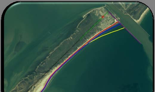
4 Point Lookout, NY Study Area Study Area 3
 200,000 150,000 100,000 50,000 25 0 Annual Shoreline Change Rate 0 1 2 3 4 5 6 7 Distance Alongshore (miles) Shoreline Change Rate (ft/year) 20 15 10 5 0-5 -10-15 -20 Area of Reoccurring")
5 Point Lookout, NY Model Setup Modified Wave input to account for shoaling and sheltering 300,000 Mean Net Annual Transport (Southward) 250,000 Transport (c.y.) 200, , ,000 50, Annual Shoreline Change Rate Distance Alongshore (miles) Shoreline Change Rate (ft/year) Area of Reoccurring Nourishment Distance Alongshore (miles) Initial Shoreline Regional Contour IRM & Jetties Groins Seawall Wave Gauge Modeled Shoreline 4


6 Point Lookout, NY - Results 1994 Shoreline Comparison 1994 Shoreline Regional Contour IRM & Jetties Groins Seawall Wave Gauge Modeled Shoreline 5

7 Modeling Results Point Lookout, NY - Results Existing Condition -No Action Results of Alternatives a) No action is not feasible for the SDR Project requirements I. Two additional groins had greatest effect on shoreline position, with little difference between the full length and shortened groins II. III. Existing Condition -Reoccurring Nourishment Four groins show greater shoreline accretion across Hempstead Beach, providing long-term stability for the erosion hotspot Terminal groin extension provides additional sand retention IV. Reoccurring nourishments are critical to project success b) Long-term stability of shoreline at erosional hotspot can be mitigated with frequent nourishments. Structures spanning the erosional area were modeled and found to increase accretion at the shoreline, suggesting structures will best mitigate shoreline control. c) GenCade was successful in evaluating long-term effects to the shoreline for the 50-year planning period 6


8 Onslow Bay, NC Problem Statement Use GenCade to Improve understanding of the regional sediment system Provide information for a sediment budget Bogue Banks near Bogue Inlet Fort Fisher Revetment North weir jetty at Masonboro Inlet 7

9 Onslow Bay, NC - Overview 8

 Q parameters: K1=0.6; K2=0.")
10 Onslow Bay - Procedure Inputs: Grid spacing = 300 ft Shorelines: 1997 and WIS wave data Grain size = 0.17mm Berm height = 4.5 ft (MHW) Closure depth = 26.5 ft (MHW) Q parameters: K1=0.6; K2=0.4 Validation period: with composite wave data. 9
 Fort Macon 2002 37.0 Pine Knoll Shores 2002 40.0 Indian Beach 2002 57.")
 1997 267,655 187,359 80,297 1998 2,240,267 1,568,187 672,080 1999 1,040,919 728,643 312,276 2000 1,701,659 1,191,161 510,498 2001 834,645 584,252 250,394 2002 861,074 602,752 258,322")
11 Secondary - East Grid Setup Bogue Inlet Beach fills Beaufort Inlet Beaufort Inlet 1997 initial shoal volume estimated by subtracting yearly shoal volume change calculated by Olsen (2006) from the volume of the 2004 survey Used USACE published beach fill volumes Beach Location Date Added Berm width (ft) Fort Macon Pine Knoll Shores Indian Beach Emerald Isle (phase 2) Used yearly maintenance dredging records and split volumes into East and West bypassing bars Outer channel dredging (cy) From west byp. bar (70%, cy) From east byp. bar (30%, cy) , ,359 80, ,240,267 1,568, , ,040, , , ,701,659 1,191, , , , , , , , ,144, , , , , ,936 Yearly average: 1,113, , ,912 10
; dredged to 47 ft since 1994.")
12 Representation of Beaufort Inlet in GenCade West attachment bar West bypassing bar East attachment bar Nearshore placement site Offshore disposal area Ebb shoal proper East bypassing bar Estimated ebb shoal volume in 1900: 58.4 Mcy Estimated ebb shoal volume in 2004: 37.4 Mcy Channel depth in 1900 was 15 ft (MLW); dredged to 47 ft since Yearly average maintenance dredging 1 Mcy; all disposed offshore until


 2003 51.")
13 Primary Grid Setup Almost no data on this stretch of coast 7 Inlets all at equilibrium Includes 3 beach fills on Bogue Banks Gated BC at Masonboro north jetty Dredging of Rich Inlet New River Inlet New Topsail Inlet Bogue Inlet Beach Fills Bear Inlet Brown s Inlet Rich Inlet Mason Inlet Beach Location Date Added Berm width (ft) Pine Knoll Shores Indian Beach Emerald Isle (Phase 2) Inlet Date Volume Dredged, cy Rich Inlet , , ,000 12


14 Secondary - West Grid Setup Inlet Date Volume dredged cy Carolina Beach Inlet ,500 Carolina Beach Inlet ,525,500 Masonboro Inlet ,672,200 Carolina Beach Inlet ,000 Rich Inlet ,000 Carolina Beach Inlet ,000 Carolina Beach Inlet ,188,000 Carolina Beach Inlet ,000 Rich Inlet ,000 Masonboro Inlet ,302,500 Carolina Beach Inlet ,000 Rich Inlet ,000 Carolina Beach Inlet ,392,700 Location Date Added Berm Width (ft) Kure Beach Kure Beach Wrightsville Beach Masonboro Island Carolina Beach Figure Eight Island Figure Eight Island Carolina Beach Figure Eight Island Figure Eight Island Wrightsville Beach Figure Eight Island BUILDING Kure Beach STRONG Carolina Beach inlets Masonboro with north weir jetty Dredging of Rich, Masonboro and Carolina Beach Inlets Includes Fort Fisher revetment and Carolina Beach seawall Beach fills Rich Inlet Mason Inlet Masonboro Inlet Carolina Beach Inlet Carolina Beach seawall Ft. Fisher revetment 13
15 Results: Secondary-East Grid Final Shoreline Skill Score Secondary-East Grid BSS 0.63 RMSE (ft) 16.5 Bias (ft) 40.5 Shoreline Change R
 -6.64 Bias (ft) 55.6 Shoreline Change R 2 0.")
16 Results: Primary Grid Final Shoreline Skill Score Primary grid BSS 0.37 RMSE (ft) Bias (ft) 55.6 Shoreline Change R
17 Results: Secondary-West Grid Final Shoreline Skill Score Secondary-West Grid BSS 0.71 RMSE (ft) 6.6 Bias (ft) 67.0 Shoreline Change R
 - c c (Ill G) E ;:; G) (I) c (Ill G) :s 2,000,000 ~----------------------------------------------------------------------- 1,500,000 1,000,000 500,000 0-500,000 Nlet, gross,, SWand NE diirected")
18 Mean Transport, (Ill ~ (;',: 0.. a.!i) - c c (Ill G) E ;:; G) (I) c (Ill G) :s 2,000,000 ~ ,500,000 1,000, , ,000 Nlet, gross,, SWand NE diirected transport av erag ed over.20 year simujation period + Sout h-we.ste rly c Net t ran sport - SW an d NE directed tra nsp ort - - Gross t ransport Dista nee West of Cape Lookourt, mile c 17
19 Onslow Bay, NC - Summary Goodness of fit of the calculated shoreline ( ) ranges from 0.37 to 0.71 (Brier Skills Score) with correlation coefficients (R 2 ) ranging from 0.70 to Results from the 20 year simulation indicate a gross mean sand transport on the order of 1,000,000 cy/yr consistently across all of Onslow Bay. The net transport is generally small, less than 200,000 cy/yr, and directed to the northeast from New River Inlet to Beaufort Inlet and to the southwest for the southern half of the bay. Results indicate Beaufort Inlet is a convergent nodal point, meaning the net sand transport is into the inlet shoals (or into the bay) on both sides of the inlet. Hence, dredging of the shoal should have minimal net impact to adjacent beach. 18
20 St. Johns County, FL Problem Statement What is the optimal dredging volume and interval, and beach placement volume and interval that will supply adequate sand to maintain two Shore Protection Projects in St. Johns County? GenCade used to help answer: What is the volumetric limit (cubic yards of sediment) that can be mined regularly from the ebb shoal in its present condition which does not cause a significant long-term effect on the morphology and volumetric recovery of the shoal? How much sediment and what nourishment interval is required to maintain present volume of the active and planned Shore Protection Projects? 19

21 St. Johns County, FL GenCade Grid Setup Input: 1986, 1999 Shorelines Waves Dredging/Placement Information Structures Model Calibration Also Dependent On: Equilibrium Shoal Volumes Inlet Bypassing Rates & Locations Regional Contour Interpolation of Waves Between Gage Stationing 20
 Ebb-tidal Delta Volume Change Alt Bl --Ait B2 ----Ait Cl Alt C2 21")
22 St. Johns County, FL Ebb-Tidal Delta Volume Change Ebb-tidal Delta Volume Change., ~ ' -.,---"T'- '-. -., ' Alt A4 I Time (years) Ebb-tidal Delta Volume Change Alt Bl --Ait B2 ----Ait Cl Alt C2 21


23 St. Johns County, FL - Results Plotted on SMS Grid 40 cy/lft 5 yr 50 cy/lft 5 yr 100 cy/lft 5 yr 70 cy/lft 5 yr 80 cy/lft 5 yr 125 cy/lft 5 yr 125 cy/lft 5 yr 22


24 St. Johns County, FL Volumetric Results Final Volume Change 23
25 St. Johns County, FL - Summary The performance and estimate of certainty in GenCade as a sediment management planning tool is relative to the accuracy of the calibration. Furthermore, extensive analysis of measured data must be performed to properly inform the model on realistic bounds in a 3-dimensional morphologic environment. Though not all 3-dimensional morphologic processes are represented in the model, most general inferences about sediment transport and bypassing within the coastal zone can be applied to calculating future sediment budgets with GenCade. The benefits of coordinating and modifying dredging intervals can be explored simultaneously with varying beach fill volumes and intervals. The greatest benefit lies in determining optimal mobilization periods and coordinating regional efforts to save in mobilization and demobilization costs for dredging and beach fill placement. 24

26 Overview Sargent Beach and Matagorda Peninsula, TX Project Areas 25
27 Calibration Sargent Beach and Matagorda Peninsula GenCade Input 1995 and 2000 shorelines Waves (WIS 73060, 73058,73055, 73053) Sargent Beach revetment Mitchell s Cut and Mouth of the Colorado River 26
28 Sargent Beach and Matagorda Peninsula: Net Transport MSC Mitchell s Cut MCR Cedar Lakes Pass 27

29 Sargent Beach and Matagorda Peninsula: Measured Shoreline Change , i~=~m~e~a=s~ur=e~d~s~h=o~re~li=n~e~c~h=a= ng~e~~-----! a l~=~c~a~l c~u~la~te~d~s~h~o~r~e l~in~e~c~h~a~n~g~e_r----~~ 30 ~ ~ ~ H~ 20 - ~ mr-~ ft-~ ~+ 10 c.c "' #.-~H-~~~~~~HH~~r*~ ~~-,, ~~~~-.~-H~--~~-+~~~~~~-r----~~~ ~ ~ ~ ~ -50 Distance from Grid Origin, ft 28
30 Sargent Beach - Problem Statement Sargent Beach fastest eroding beach in Texas Determine feasibility of structural solutions to reduce erosion - protect the beach habitat - protect Gulf Intracoastal Waterway Refined problem statement in Phase 2 - segmented breakwaters - adaptive and scalable plan - minimal downdrift impacts - multiple layouts to accommodate incremental funding 29
31 Sargent Beach Alternatives Sargent Beach alternatives use shorter grid than calibration Breakwater alternatives required shorter grid due to computational time Alt 0: No Action Alt 1: 3,000,000 cubic yard beach fill Alt 2: Single Groin Alt 3: Groin Field Alt 4: Breakwaters Phase 1: 10 Breakwaters; 220 ft Breakwaters; 330 ft Gaps Phase 2: 15 Breakwaters Final Phase: 81 Breakwaters 30
32 Sargent Beach Alternatives Alt 0: No Action About 6 miles of shoreline recedes to revetment after 5 years Gross transport about 400,000 cy/yr over entire domain 31


33 Sargent Beach Alternatives Alt 1 Alt 1: 3 million cubic yard beach fill over 10 miles Placement density of 57 cy/linear foot Added berm width of 100 ft Beach fill does not increase beach width Additional nourishments required to protect the beach (not cost effective) 32
34 Sargent Beach Alternatives Alt 2: Single Groin East of Mitchell s Cut plus Beach Fill Beach Fill identical to Alt 1 Unrealistically long groin to demonstrate maximum trapping capacity Alt 2a: Single Groin Only Groin does not have impact on shoreline change northeast of ft Northeast of ft, Alt 2 is identical to Alt 1 and Alt 2a is identical to Alt 0 33
35 Sargent Beach Alternatives Alt 3: Groin Field plus Beach Fill Beach fill identical to Alt 1 Includes 28 groins of 600 ft spaced 1800 ft apart Alt 3a: Groin Field Only Groin field has little effect on shoreline in front of revetment Groin protects shoreline at northern end of revetment, but recedes to almost same location as Alt 0 along most of the revetment 34

36 Sargent Beach Alternatives Alt 4: 10 breakwaters placed at 350 ft offshore Breakwater length = 220 ft Gap size = 330 ft 35


37 Sargent Beach Alternatives Alt 4, Phase 2: 15 breakwaters placed at 350 ft offshore Breakwater length = 220 ft Gap size = 330 ft 36

38 Sargent Beach Alternatives Alt 4, Phase 3: 81 breakwaters placed at 350 ft offshore Breakwater length = 220 ft Gap size = 330 ft 37
39 Sargent Beach, TX - Summary The best structural alternative at Sargent Beach is breakwaters Multiple offshore distances and depths were tested with the breakwaters at Sargent Beach Several phases were simulated for selected Sargent Beach breakwater setup Mitigation beach fill necessary southwest of Mitchell s Cut for Sargent Beach breakwaters 38
40 Matagorda Peninsula - Problem Statement Matagorda Peninsula breached by ephemeral inlets in past Determine feasibility of structural solutions to reduce erosion - protect beach habitat - reduce storm damage - reduce sediment impoundment along the MCR east jetty Refined problem statement in Phase 2 - groin field between 3 Mile Cut and MCR - project goal to widen beach by 200 ft - design so project does not impact 3 Mile Cut 39
41 Matagorda Peninsula Alternatives - Grid extends from 3.3 miles southwest of Mitchell s Cut to south west of MCR - 28 miles long - Smaller cell size between 3 Mile Cut and MCR - 5 and 16 year long simulations 40
42 Matagorda Peninsula Alternatives Alt 0: 1: 2: 3: 4: 5: No 7 53 groins, Action ft long, ft ft spacing 41

43 Matagorda Peninsula Alternatives Alt 0 Alt 1 No beach fills Alt 2 115,000 cy/yr of bypassing around MCR P = 0.3 Alt 4 Alt 5 Alt 3 42
44 Matagorda Peninsula Alternatives After 5 Years After 16 Years Based on preliminary simulations, Alt 5 was selected as the design alternative Additional variations of Alt 5 were simulated 43

45 Matagorda Peninsula Alt 5 After 5 Years Shifted After 16 Years Shifted 44
46 Matagorda Peninsula Alt 5 Comparison P = 0.3 for final design Compare No Action to Alt 5 (no beach fill or bypassing) After 5 years, greatest accretion to northeast of first groin (less than 100 ft) After 16 years, about 200 ft of accretion northeast of first groin After 16 years, almost 300 ft of shoreline advance northeast of MCR After 5 Years After 16 Years 45
47 Matagorda Peninsula Alt 5 After 5 Years With 200,000 cy/yr of bypassing, erosion occurs with and without beach fills All cases result in accretion northeast of first groin After 16 Years Bypassing between 0 and 200,000 cy/yr may provide best result 46
48 Matagorda Peninsula - Summary Shifting the groin field to the southwest significantly improved the results Of the groin configurations modeled at Matagorda Peninsula, three groins of 800 ft spaced 1600 ft apart produced the best results The rate of bypassing and the construction of a beach fill affects the shoreline change in the area 47
Tanya M. Beck. Kelly Legault. Research Physical Scientist Coastal & Hydraulics Lab, ERDC Vicksburg, MS
 Inlet And Adjacent Shoreline Processes at Cascading Time Scales Using the Coastal Modeling System and GenCade Tanya M. Beck Research Physical Scientist Coastal & Hydraulics Lab, ERDC Vicksburg, MS Kelly
GenCade Application at Onslow Bay, North Carolina
 GenCade Application at Onslow Bay, North Carolina by Ashley E. Frey, Sophie Munger, Greg L. Williams, Michael J. Wutkowski, and Kevin B. Conner PURPOSE: This Coastal and Hydraulics Engineering Technical
Kelly Legault, Ph.D., P.E. USACE SAJ
 Kelly Legault, Ph.D., P.E. USACE SAJ Report Documentation Page Form Approved OMB No. 0704-0188 Public reporting burden for the collection of information is estimated to average 1 hour per response, including
Shoreline Change Modeling Using One-Line Models: Application and Comparison of GenCade, Unibest, and Litpack
 Shoreline Change Modeling Using One-Line Models: Application and Comparison of GenCade, Unibest, and Litpack by Kimberly E. Townsend, Robert C. Thomas, and Ashley E. Frey PURPOSE: The purpose of this Coastal
Evaluation of Placement Alternatives for Matagorda Ship Channel Bottleneck Removal
 Evaluation of Placement Alternatives for Matagorda Ship Channel Bottleneck Removal James Rosati III Ashley E. Frey CPT Grays Harbor, WA Wood Wood chips Flour Other CMS Shark River Inlet, NJ US Army Corps
Inlet Management Study for Pass-A-Grille and Bunces Pass, Pinellas County, Florida
 Inlet Management Study for Pass-A-Grille and Bunces Pass, Pinellas County, Florida Final Report Submitted By Ping Wang, Ph.D., Jun Cheng Ph.D., Zachary Westfall, and Mathieu Vallee Coastal Research Laboratory
Figure 1 Example feature overview.
 1. Introduction This case focuses on the northeastern region of Onslow Bay, NC, and includes an initial shoreline, regional contour, wave gauges, inlets, dredging, and beach fills. Most of the features
North Carolina s Terminal Groins at Oregon Inlet and Fort Macon Descriptions and Discussions
 Attachment 2 North Carolina s Terminal Groins at Oregon Inlet and Fort Macon Descriptions and Discussions Oregon Inlet Terminal Groin Introduction/Background Oregon Inlet was created by a hurricane on
CRC Inlet Management Study. Matt Slagel Shoreline Management Specialist
 CRC Inlet Management Study Matt Slagel Shoreline Management Specialist Study Origin CRC shall study feasibility of creating new AEC for lands adjacent to mouth of Cape Fear River (HB 819) Collaborate with
Modeling Sediment Transport Along the Upper Texas Coast
 Modeling Sediment Transport Along the Upper Texas Coast David B. King Jr. Jeffery P. Waters William R. Curtis Highway 87 roadbed, Jefferson County Galveston District Corps Sabine Pass to San Luis Pass
US Beach Nourishment Experience:
 Beach Nourishment: Introduction of new sand to the beach by truck or dredge Large beach >1 million cubic yards (100,000 dump truck loads) Funding is a combination of federal, state, local & private Also
BRRAKING WAVE FORCES ON WALLS
 CETN-III-38 3/88 BRRAKING WAVE FORCES ON WALLS PURPOSE: To introduce the Goda method as an alternative to the Minikin method for the determination of breaking wave forces on semirigid wall structures.
EVALUATION OF BEACH EROSION UP-DRIFT OF TIDAL INLETS IN SOUTHWEST AND CENTRAL FLORIDA, USA. Mohamed A. Dabees 1 and Brett D.
 EVALUATION OF BEACH EROSION UP-DRIFT OF TIDAL INLETS IN SOUTHWEST AND CENTRAL FLORIDA, USA Mohamed A. Dabees 1 and Brett D. Moore 1 The paper discusses the analysis of up-drift beach erosion near selected
New Jersey Coastal Zone Overview. The New Jersey Beach Profile Network (NJBPN) 3 Dimensional Assessments. Quantifying Shoreline Migration
 3 Dimensional Assessments. Quantifying Shoreline Migration") New Jersey Coastal Zone Overview The New Jersey Beach Profile Network (NJBPN) Objectives Profile Locations Data Collection Analyzing NJBPN Data Examples 3 Dimensional Assessments Methodology Examples Quantifying
New Jersey Coastal Zone Overview The New Jersey Beach Profile Network (NJBPN) Objectives Profile Locations Data Collection Analyzing NJBPN Data Examples 3 Dimensional Assessments Methodology Examples Quantifying
( max)o Wind Waves 10 Short Swell (large wave steepness) 25 Long Swell (small wave steepness) 75
o Wind Waves 10 Short Swell (large wave steepness) 25 Long Swell (small wave steepness) 75") CEPi-I-18 REvKn, 3188 IRREGULAR WAVE DIFFRACTION BY GODA'S KETHOD PURPOSE : To provide a simplified method for determining random wave diffraction coefficients for a semi-infinite breakwater. GENERAL :
CEPi-I-18 REvKn, 3188 IRREGULAR WAVE DIFFRACTION BY GODA'S KETHOD PURPOSE : To provide a simplified method for determining random wave diffraction coefficients for a semi-infinite breakwater. GENERAL :
Air-Sea Interaction Spar Buoy Systems
 DISTRIBUTION STATEMENT A: Distribution approved for public release; distribution is unlimited Air-Sea Interaction Spar Buoy Systems Hans C. Graber CSTARS - University of Miami 11811 SW 168 th Street, Miami,
Characterizing The Surf Zone With Ambient Noise Measurements
 Characterizing The Surf Zone With Ambient Noise Measurements LONG-TERM GOAL Grant Deane Marine Physical Laboratory Scripps Institution of Oceanography La Jolla, CA 93093-0213 phone: (619) 534-0536 fax:
UPPER BEACH REPLENISHMENT PROJECT RELATED
 ASSESSMENT OF SAND VOLUME LOSS at the TOWNSHIP of UPPER BEACH REPLENISHMENT PROJECT RELATED to the LANDFALL OF HURRICANE SANDY - PURSUANT TO NJ-DR 4086 This assessment is in response to Hurricane Sandy
GenCade: Introduction, Background, and Formulation
 GenCade: Introduction, Background, and Formulation Ashley Frey Ashley.E.Frey@usace.army.mil Tanya Beck Tanya.M.Beck@usace.army.mil March 7, 2012 CMS Shark River Inlet, NJ CPT Grays Harbor, WA Wood Wood
Appendix E Cat Island Borrow Area Analysis
 Appendix E Cat Island Borrow Area Analysis ERDC/CHL Letter Report 1 Cat Island Borrow Area Analysis Multiple borrow area configurations were considered for Cat Island restoration. Borrow area CI1 is located
Coastal and Hydraulics Laboratory
 ERDC/CHL TR-11-2 Coastal Inlets Research Program Analysis of Dredged Material Placement Alternatives for Bottleneck Removal, Matagorda Ship Channel, Texas James Rosati III, Ashley E. Frey, Mitchell E.
A Modeling Study of Coastal Sediment Transport and Morphology Change
 A Modeling Study of Coastal Sediment Transport and Morphology Change Honghai Li 1, Alejandro Sanchez 1, Mitchell E. Brown 1, Irene M. Watts 2, Zeki Demirbilek 1, Julie D. Rosati 1, and David R. Michalsen
National Shoreline Erosion Control Demonstration Program Overview
 National Shoreline Erosion Control Demonstration Program Overview William R. Curtis 1 (Phone: (601) 634-3040, Fax: (601) 634-3080, CURTISW@wes.army.mil), Joan Pope 1 (Phone: (601) 634-3040, Fax: (601)
Salt Ponds Shore Zone Modeling for Breakwater Placement: Summary Report
 Salt Ponds Shore Zone Modeling for Breakwater Placement: Summary Report Virginia Institute of Marine Science May 2014 Salt Ponds Shore Zone Modeling for Breakwater Placement: Summary Report For Waterway
Table 4. Volumetric Change Rates Pre-Project and Post-Project for the Town of Duck
 V. VOLUMETRIC CHANGES General Volumetric changes measured over the entire monitoring area for various time periods are provided in Table 4. The volume changes are given in terms of cubic yards/foot of
MOREHEAD CITY HARBOR, NC. Dredged Material Management Plan (DMMP)
") MOREHEAD CITY HARBOR, NC Dredged Material Management Plan (DMMP) Public Meeting/Info Session 15 January 2014 US Army Corps of Engineers Morehead City Harbor DMMP Presentation Topics Morehead City Harbor
MOREHEAD CITY HARBOR, NC Dredged Material Management Plan (DMMP) Public Meeting/Info Session 15 January 2014 US Army Corps of Engineers Morehead City Harbor DMMP Presentation Topics Morehead City Harbor
CHAPTER 281 INFLUENCE OF NEARSHORE HARDBOTTOM ON REGIONAL SEDIMENT TRANSPORT
 CHAPTER 281 INFLUENCE OF NEARSHORE HARDBOTTOM ON REGIONAL SEDIMENT TRANSPORT Paul C.-P. Lin, Ph.D., P.E. 1 and R. Harvey Sasso, P.E. 2 ABSTRACT The influence of nearshore hardbottom on longshore and cross-shore
NUMERICAL SIMULATION OF SEDIMENT PATHWAYS AT AN IDEALIZED INLET AND EBB SHOAL
 In: Proceedings Coastal Sediments 03. 2003. CD-ROM Published by World Scientific Publishing Corp. and East Meets West Productions, Corpus Christi, Texas, USA. ISBN 981-238-422-7. NUMERICAL SIMULATION OF
KEYNOTE PRESENTATION FSBPA olsen
 AMELIA ISAND, FLORIDA BEACH MANAGEMENT PARTNERING AND PERSERVERENCE Erik Olsen, PE associates, inc. KEYNOTE PRESENTATION FSBPA 2009 IN ORDER TO ADDRESS SHORE PROTECTION TODAY LOCAL INTERESTS PARTNER WITH:
Regular Workshop October 20, 2014 Agenda Item: Dr. Albert E. Browder, PE; Olsen Associates, Inc.
 Regular Workshop October 20, 2014 Agenda Item 8 Agenda Item: Presenter: Summary: Beach Update Town Manager; Dr. Albert E. Browder, PE; Olsen Associates, Inc. At the January 21, 2014 Regular Workshop Meeting,
First Year Morphological Evolution of an Artificial Berm at Fort Myers Beach, Florida
 University of South Florida Scholar Commons Geology Faculty Publications Geology 1-2012 First Year Morphological Evolution of an Artificial Berm at Fort Myers Beach, Florida Katherine Brutsche University
IMPACTS OF COASTAL PROTECTION STRATEGIES ON THE COASTS OF CRETE: NUMERICAL EXPERIMENTS
 IMPACTS OF COASTAL PROTECTION STRATEGIES ON THE COASTS OF CRETE: NUMERICAL EXPERIMENTS Tsanis, I.K., Saied, U.M., Valavanis V. Department of Environmental Engineering, Technical University of Crete, Chania,
Coastal Sediment Transport Modeling Ocean Beach & San Francisco Bight, CA
 1 Coastal Sediment Transport Modeling Ocean Beach & San Francisco Bight, CA Honghai Li and Lihwa Lin Engineering Research and Development Center U.S. Army Corps of Engineers Frank Wu, Lisa Andes, and James
Analysis of Packery Channel Public Access Boat Ramp Shoreline Failure
 Journal of Coastal Research SI 59 150-155 West Palm Beach, Florida 2011 Analysis of Packery Channel Public Access Boat Ramp Shoreline Failure Christopher W. Reed and Lihwa Lin URS Corporation 1625 Summit
Nearshore Dredged Material Placement Pilot Study at Noyo Harbor, CA
 1 Nearshore Dredged Material Placement Pilot Study at Noyo Harbor, CA Noyo Cove N 2011 National Conference on Beach Preservation Technology 9-11, February 2011 Lihwa Lin, Honghai Li, Mitchell Brown US
OECS Regional Engineering Workshop September 29 October 3, 2014
 B E A C H E S. M A R I N A S. D E S I G N. C O N S T R U C T I O N. OECS Regional Engineering Workshop September 29 October 3, 2014 Coastal Erosion and Sea Defense: Introduction to Coastal/Marine Structures
Town of Duck, North Carolina
 Tracking No. 00.00.2010 Erosion Mitigation And Shoreline Management Feasibility Study Town of Duck, North Carolina Coastal Planning & Engineering of North Carolina August 15, 2012 Tom Jarrett Robert Neal
Internal Waves and Mixing in the Aegean Sea
 Internal Waves and Mixing in the Aegean Sea Michael C. Gregg Applied Physics Laboratory, University of Washington 1013 NE 40 th St. Seattle, WA 98105-6698 phone: (206) 543-1353 fax: (206) 543-6785 email:
The purpose and needs of the Figure Eight Island Inlet and Shoreline Management Project are as follows:
 Chapter 2 PURPOSE AND NEEDS 1. What are the purpose and needs of this project? The main concern of residents and owners at Figure Eight Island are economic losses resulting from damages to structures and
Assateague Island National Seashore North End Restoration Project Timeline
 Assateague Island National Seashore North End Restoration Project Timeline Date Event Some information provided in the Project Introduction document. Detailed events are available in a timeline compiled
FINAL ENVIRONMENTAL IMPACT STATEMENT ON BROWARD COUNTY SHORE PROTECTION PROJECT SEGMENTS II AND III BROWARD COUNTY, FLORIDA
 FINAL ENVIRONMENTAL IMPACT STATEMENT ON BROWARD COUNTY SHORE PROTECTION PROJECT SEGMENTS II AND III BROWARD COUNTY, FLORIDA 1. PROJECT PURPOSE AND NEED 1.1. PROJECT AUTHORITY. 1.1.1. INITIAL AUTHORIZATION.
Volume and Shoreline Changes along Pinellas County Beaches during Tropical Storm Debby
 Volume and Shoreline Changes along Pinellas County Beaches during Tropical Storm Debby Ping Wang and Tiffany M. Roberts Coastal Research Laboratory University of South Florida July 24, 2012 Introduction
Proceedings, 2001National Conference on Beach Preservation Technology, pp COASTAL INLET BANK EROSION. William C.
 Proceedings, 2001National Conference on Beach Preservation Technology, pp. 274-283 COASTAL INLET BANK EROSION William C. Seabergh 1 Abstract: Much focus is placed on beach erosion on the open coast. However,
PREDICTION OF ERODED VERSUS ACCRETED BEACHES
 CETN-II-2 6/88 PREDICTION OF ERODED VERSUS ACCRETED BEACHES PURPOSE: To present revised procedures for predicting whether a beach profile of a specified sand size will tend to erode or accrete under incident
Long Term Success and Future Approach of the Captiva and Sanibel Islands Beach Renourishment Program
 2017 National Conference on Beach Preservation Technology February 8-10, 2017; Stuart, Florida Long Term Success and Future Approach of the Captiva and Sanibel Islands Beach Renourishment Program Thomas
Examples of Carter Corrected DBDB-V Applied to Acoustic Propagation Modeling
 Naval Research Laboratory Stennis Space Center, MS 39529-5004 NRL/MR/7182--08-9100 Examples of Carter Corrected DBDB-V Applied to Acoustic Propagation Modeling J. Paquin Fabre Acoustic Simulation, Measurements,
Sediment Transport Analysis Village of Asharoken, New York
 Sediment Transport Analysis Village of Asharoken, New York NORTH SHORE OF LONG ISLAND, NEW YORK COMBINED EROSION CONTROL AND STORM DAMAGE PROTECTION FEASIBILITY STUDY FINAL REPORT August 2004 Cell 0 Asharoken
Gly 558. Introduction to Coastal Management. Aeolian Processes and Dunes. Namib Coastal Desert. What Can Dunes Tell Us About the Coastal System?
 Gly 558 Introduction to Coastal Management 300m high Namib Coastal Desert GE Crescent dunes Onshore prevailing wind Benguella Current Aeolian Processes and Dunes Linear dunes Fog What Can Dunes Tell Us
ST. JOSEPH PENINSULA, GULF COUNTY, FLORIDA Beach Re-Nourishment and Environmental Enhancement Project RECOMMENDATIONS
 ST. JOSEPH PENINSULA, GULF COUNTY, FLORIDA Beach Re-Nourishment and Environmental Enhancement Project RECOMMENDATIONS January 23, 2018 543 Harbor Boulevard, Suite 204 Destin, Florida 32541 850.654.1555
High-Frequency Scattering from the Sea Surface and Multiple Scattering from Bubbles
 High-Frequency Scattering from the Sea Surface and Multiple Scattering from Bubbles Peter H. Dahl Applied Physics Laboratory College of Ocean and Fisheries Sciences University of Washington Seattle, Washington
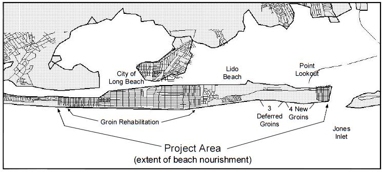
Atlantic Coast of Long Island, Jones Inlet to East Rockaway Inlet, Long Beach Island, NY Construction Update
 Atlantic Coast of Long Island, Jones Inlet to East Rockaway Inlet, Long Beach Island, NY Construction Update June 2016 US Army Corps of Engineers Project Purpose Three specific damage mechanisms of coastal
ALTERNATIVES FOR COASTAL STORM DAMAGE MITIGATION
 ALTERNATIVES FOR COASTAL STORM DAMAGE MITIGATION Dave Basco Old Dominion University, Norfolk, Virginia, USA National Park Service Photo STRUCTURAL (changes to natural, physical system) hardening (seawalls,
SACO RIVER AND CAMP ELLIS BEACH SACO, MAINE SECTION 111 SHORE DAMAGE MITIGATION PROJECT APPENDIX F ECONOMIC ASSESSMENT
 SACO RIVER AND CAMP ELLIS BEACH SACO, MAINE SECTION 111 SHORE DAMAGE MITIGATION PROJECT APPENDIX F ECONOMIC ASSESSMENT Department of the Army New England District, Corps of Engineers 696 Virginia Road
Marine Mammal Acoustic Tracking from Adapting HARP Technologies
 DISTRIBUTION STATEMENT A: Approved for public release; distribution is unlimited. Marine Mammal Acoustic Tracking from Adapting HARP Technologies Sean M. Wiggins and John A. Hildebrand Marine Physical
STORM RESPONSE SIMULATION
 APPENDIX V STORM RESPONSE SIMULATION Final Environmental Impact Statement Village of Bald Head Island Shoreline Protection Project Brunswick County, North Carolina Delft3D Storm Response Simulations With
ENGINEERING STUDY OF INLET ENTRANCE HYDRODYNAMICS: GRAYS HARBOR, WASHINGTON, USA
 Cialone, M.A., and Kraus, N.C. (2001). Engineering Study of Inlet Entrance Hydrodynamics: Grays Harbor, Washington, USA. Proceedings of Coastal Dynamics 01, ASCE, Reston, VA, 413-422. ENGINEERING STUDY
CLAM PASS RESTORATION AND MANAGEMENT PLAN BATHYMETRIC MONITORING REPORT NO. 7 Including Interior Bay Dredge Cuts and Tidal Data
 CLAM PASS RESTORATION AND MANAGEMENT PLAN BATHYMETRIC MONITORING REPORT NO. 7 Including Interior Bay Dredge Cuts and Tidal Data Submitted to: Florida Department of Environmental Protection DEP File No.
USE OF SEGMENTED OFFSHORE BREAKWATERS FOR BEACH EROSION CONTROL
 .. CETN-III-22 4/84 PURPOSE: USE OF SEGMENTED OFFSHORE BREAKWATERS FOR BEACH EROSION CONTROL To provide information on the functional application of and general design considerations for using offshore
Beach Nourishment Impact on Beach Safety and Surfing in the North Reach of Brevard County, Florida
 Beach Nourishment Impact on Beach Safety and Surfing in the North Reach of Brevard County, Florida Prepared by John Hearin, Ph.D. Coastal Engineering Vice Chairman Cocoa Beach Chapter Port Canaveral Patrick
Beach Restoration in Okaloosa and Walton Counties. FSBPA Technology Conference Clearwater, FL
 Beach Restoration in Okaloosa and Walton Counties FSBPA Technology Conference Clearwater, FL Presented by: Duncan Greer, E.I. February 5, 2015 PRESENTATION OUTLINE 1. Overview of Project Locations 2. Eglin
FINDING OF NO SIGNIFICANT IMPACT
 DEPARTMENT OF THE ARMY CHARLESTON DISTRICT, CORPS OF ENGINEERS 69A HAGOOD AVENUE CHARLESTON, SOUTH CAROLINA 29403-5107 FINDING OF NO SIGNIFICANT IMPACT EDISTO BEACH COASTAL STORM DAMAGE REDUCTION GENERAL
Implementation of Structures in the CMS: Part IV, Tide Gate
 Implementation of Structures in the CMS: Part IV, Tide Gate by Honghai Li, Alejandro Sanchez, and Weiming Wu PURPOSE: This Coastal and Hydraulics Engineering Technical Note (CHETN) describes the mathematical
Available online at ScienceDirect. Procedia Engineering 116 (2015 )
") Available online at www.sciencedirect.com ScienceDirect Procedia Engineering 116 (2015 ) 320 325 8th International Conference on Asian and Pacific Coasts (APAC 2015) Department of Ocean Engineering, IIT
Available online at www.sciencedirect.com ScienceDirect Procedia Engineering 116 (2015 ) 320 325 8th International Conference on Asian and Pacific Coasts (APAC 2015) Department of Ocean Engineering, IIT
Waves, Bubbles, Noise, and Underwater Communications
 Waves, Bubbles, Noise, and Underwater Communications Grant B. Deane Marine Physical Laboratory, Scripps Institution of Oceanography UCSD, La Jolla, CA 92093-0238 phone: (858) 534-0536 fax: (858) 534-7641
COASTAL EVOLUTION MODELING AT MULTIPLE SCALES IN REGIONAL SEDIMENT MANAGEMENT APPLICATIONS
 1920 COASTAL EVOLUTION MODELING AT MULTIPLE SCALES IN REGIONAL SEDIMENT MANAGEMENT APPLICATIONS HANS HANSON 1, KENNETH J. CONNELL 2, MAGNUS LARSON 1, NICHOLAS C. KRAUS 3, TANYA M. BECK 3, ASHLEY E. FREY
Remote Monitoring of Dolphins and Whales in the High Naval Activity Areas in Hawaiian Waters
 DISTRIBUTION STATEMENT A: Approved for public release; distribution is unlimited. Remote Monitoring of Dolphins and Whales in the High Naval Activity Areas in Hawaiian Waters Whitlow W. L. Au and Marc
Figure79. Location map for the 10 NJBPN profile sites in Atlantic County, NJ 155
 154 Figure79. Location map for the 10 NJBPN profile sites in Atlantic County, NJ 155 ATLANTIC COUNTY SPRING 2009 to FALL 2010 The Atlantic County coastline consists of three barrier islands. Between Little
SHORE PROTECTION AND HABITAT CREATION AT SHAMROCK ISLAND, TEXAS ABSTRACT
 SHORE PROTECTION AND HABITAT CREATION AT SHAMROCK ISLAND, TEXAS M. Cameron Perry, P.E., and Daniel J. Heilman, P.E. Coastal Engineer Shiner Moseley & Associates., Inc. 555 N. Carancahua Corpus Christi,
Development of Low Volume Shape Memory Alloy Variable Ballast System for AUV Use
 Development of Low Volume Shape Memory Alloy Variable Ballast System for AUV Use Dr. Graeme J Rae Ocean Engineering Program Division of Marine and Environmental Systems Florida Institute of Technology
Internal Waves in Straits Experiment Progress Report
 DISTRIBUTION STATEMENT A: Approved for public release; distribution is unlimited. Internal Waves in Straits Experiment Progress Report Jody Klymak School of Earth and Ocean Sciences University of Victoria
Figure Eight Island Shoreline Management Project EIS. Chapter 3 PROJECT ALTERNATIVES. 1. What alternatives are evaluated in this EIS?
 Chapter 3 PROJECT ALTERNATIVES 1. What alternatives are evaluated in this EIS? This section describes in detail the various alternatives evaluated for responding to the erosion threat along the northern
ALTERNATIVES FOR COASTAL STORM DAMAGE MITIGATION AND FUNCTIONAL DESIGN OF COASTAL STRUCTURES
 The University of the West Indies Organization of American States PROFESSIONAL DEVELOPMENT PROGRAMME: COASTAL INFRASTRUCTURE DESIGN, CONSTRUCTION AND MAINTENANCE A COURSE IN COASTAL DEFENSE SYSTEMS I CHAPTER
APPENDIX A APPENDIX B APPENDIX C APPENDIX D APPENDIX E APPENDIX F APPENDIX G SEDIMENT ANALYSIS APPENDIX A WAVE & SEDIMENT MODELS CRYSTAL BALL ANALYSIS
 APPENDIX A WAVE & SEDIMENT MODELS APPENDIX B SEDIMENT ANALYSIS APPENDIX A WAVE & SEDIMENT MODELS APPENDIX C CRYSTAL BALL ANALYSIS APPENDIX D SBEACH ANALYSIS APPENDIX E GENESIS ANALYSIS APPENDIX F PREFERRED
Navy Shipbuilding Industrial Base
 Navy Shipbuilding Industrial Base May 11, 2011 David J. Berteau Senior Adviser and Director, Defense-Industrial Initiatives Report Documentation Page Form Approved OMB No. 0704-0188 Public reporting burden
BYPASS HARBOURS AT LITTORAL TRANSPORT COASTS
 BYPASS HARBOURS AT LITTORAL TRANSPORT COASTS by K. Mangor 1, I. Brøker 2, R. Deigaard 3 and N. Grunnet 4 ABSTRACT Maintaining sufficient navigation depth in front of the entrance at harbours on littoral
REPORT DOCUMENTATION PAGE
 REPORT DOCUMENTATION PAGE Form Approved OMB No. 0704-0188 Public reporting burden for this collection of information is estimated to average 1 hour per response, including the time for reviewing instructions,
Determination of Nearshore Wave Conditions and Bathymetry from X-Band Radar Systems
 Determination of Nearshore Wave Conditions and Bathymetry from X-Band Radar Systems Okey G. Nwogu Dept. of Naval Architecture and Marine Engineering University of Michigan Ann Arbor, MI 48109 Phone: (734)
AFT'LICATION OF M3vABLE-RED F'HYSICAL MODHIS To FBED1crslWM-INDUCED ERmIoN
 CETN-II-18 6189 AFT'LICATION OF M3vABLE-RED F'HYSICAL MODHIS To FBED1crslWM-INDUCED ERmIoN PURKSE: This note provides guidance and nomograms for determining if twodimensional, movable-bed physical models
MIAMI BEACH 32ND STREET HOT SPOT: NUMERICAL MODELING AND DESIGN OPTIMIZATION. Adam Shah - Coastal Engineer Harvey Sasso P.E.
 ABSTRACT MIAMI BEACH 32ND STREET HOT SPOT: NUMERICAL MODELING AND DESIGN OPTIMIZATION Adam Shah - Coastal Engineer Harvey Sasso P.E. - Principal Coastal Systems International, Inc. 464 South Dixie Highway
Coastal and Hydraulics Laboratory
 ERDC/CHL TR-17-13 Regional Sediment Management (RSM) Program Sediment Budget Analysis; Masonboro Inlet, North Carolina Kevin B. Conner and Linda S. Lillycrop August 2017 Coastal and Hydraulics Laboratory
Rogue Wave Statistics and Dynamics Using Large-Scale Direct Simulations
 Rogue Wave Statistics and Dynamics Using Large-Scale Direct Simulations Dick K.P. Yue Center for Ocean Engineering Department of Mechanical Engineering Massachusetts Institute of Technology Cambridge,
HURRICANE SANDY LIMITED REEVALUATION REPORT UNION BEACH, NEW JERSEY DRAFT ENGINEERING APPENDIX SUB APPENDIX D SBEACH MODELING
 HURRICANE SANDY LIMITED REEVALUATION REPORT UNION BEACH, NEW JERSEY DRAFT ENGINEERING APPENDIX SUB APPENDIX D SBEACH MODELING Rev. 18 Feb 2015 1 SBEACH Modeling 1.0 Introduction Following the methodology
Global Ocean Internal Wave Database
 Global Ocean Internal Wave Database Victor Klemas Graduate College of Marine Studies University of Delaware Newark, DE 19716 phone: (302) 831-8256 fax: (302) 831-6838 email: klemas@udel.edu Quanan Zheng
CHAPTER 179. Performance of a Submerged Breakwater for Shore Protection
 CHAPTER 179 Abstract Performance of a Submerged Breakwater for Shore Protection Albert E. Browder',A. Member, ASCE; Robert G. Dean 2, Member, ASCE; and Renjie Chen 3 A summary is presented of the results
DoD Coral Reef Protection and Management Program
 DoD Coral Reef Protection and Management Program PROJECT TEAM U.S. NAVY TOM EGELAND (ASN(I&E)) LORRI SCHWARTZ (NAVFAC) ALEX VIANA (NFESC) STEVE SMITH (NFESC) BOSTON UNIV. MARINE PRG. PHILLIP LOBEL MINDY
Waves, Turbulence and Boundary Layers
 Waves, Turbulence and Boundary Layers George L. Mellor Program in Atmospheric and Oceanic Sciences Princeton University Princeton NJ 8544-71 phone: (69) 258-657 fax: (69) 258-285 email: glm@splash.princeton.edu
CORPS ON THE COAST. North Carolina Coastal Conference Coastal Infrastructure Raleigh, NC April 14, Jim Medlock Chief, Programs Management Branch
 CORPS ON THE COAST North Carolina Coastal Conference Coastal Infrastructure Raleigh, NC April 14, 2015 Jim Medlock Chief, Programs Management Branch US Army Corps of Engineers OVERVIEW What Are The Corps
Using SolidWorks & CFD to Create The Next Generation Airlocks
 Using SolidWorks & CFD to Create The Next Generation Airlocks Matthew Gaffney Mechanical Engineer Geo-Centers, INC US Army Natick Soldier Center Natick, MA 01760 508-233-5557 Matthew.gaffney@natick.army.mil
MORPHOLOGIC RESPONSE TO A NEW INLET, PACKERY CHANNEL, CORPUS CHRISTI, TEXAS
 Williams, D. D., Kraus, N. C., and Anderson, L. M. 2007. Morphologic Response to a New Inlet, Packery Channel, Corpus Christi, Texas. Proceedings Coastal Sediments 07 Conference, ASCE Press, Reston, VA,
Delaware Chapter Surfrider Foundation - Indian River Inlet Monitoring
 Delaware Chapter Surfrider Foundation - Indian River Inlet Monitoring In 2012, the Delaware Surfrider Foundation Chapter formed the Surf Quality and Access Committee to focus on issues such as surf spot
RIP CURRENTS. Award # N
 RIP CURRENTS Graham Symonds School of Geography and Oceanography University College, University of New South Wales, Australian Defence Force Academy, Canberra, 2600 AUSTRALIA Phone: 61-6-2688289 Fax: 61-6-2688313
Evaluating a Prefabricated Submerged Breakwater and Double-T Sill for Beach Erosion Prevention, Cape May Point, NJ ABSTRACT
 Evaluating a Prefabricated Submerged Breakwater and Double-T Sill for Beach Erosion Prevention, Cape May Point, NJ Donald K. Stauble 1 and Michael A. Giovannozzi 2 ABSTRACT As part of the US Army Corps
Regional Sediment Management Opportunities within Intracoastal Waterway (IWW) Dredging Program in the State of Florida
 Dredging Program in the State of Florida") Regional Sediment Management Opportunities within Intracoastal Waterway (IWW) Dredging Program in the State of Florida INTRODUCTION: The topic of this Regional Sediment Management (RSM) Technical Note
Regional Sediment Management Opportunities within Intracoastal Waterway (IWW) Dredging Program in the State of Florida INTRODUCTION: The topic of this Regional Sediment Management (RSM) Technical Note
DEVELOPMENT OF PRIMARY FRAGMENTATION SEPARATION DISTANCES FOR CASED CYLINDRICAL MUNITIONS
 DEVELOPMENT OF PRIMARY FRAGMENTATION SEPARATION DISTANCES FOR CASED CYLINDRICAL MUNITIONS by William H. Zehrt, Jr., P. E. and Michelle M. Crull, PhD, P. E. U. S. Army Engineering and Support Center, Huntsville
23- Year Sand Volume Changes at Site 132, 15th Street, Brigantine
 149 Figure75. Location map for the 9 NJBPN profile sites in Atlantic County, NJ ATLANTIC COUNTY SPRING 2008 to FALL 2009 150 The Atlantic County oceanfront shoreline consists of three barrier islands.
Coastal Engineering Technical Note
 Coastal Engineering Technical Note CETN VI-31 The SHOALS System - A Comprehensive Surveying Tool by Larry E. Parson and W. Jeff Lillycrop PURPOSE The U.S. Army Corps ofengineers (USACE) conducts extensive
AFRL-RH-WP-TR
 AFRL-RH-WP-TR-2016-0040 C-130J BREATHING RESISTANCE STUDY George W. Miller Air Force Research Laboratory Wright-Patterson Air Force Base, OH 45433 May 2016 Final Report STINFO COPY AIR FORCE RESEARCH LABORATORY
FEDERAL INLETS DATABASE
 To appear: Proceedings 2002 National Conference on Beach Preservation Technology, FSBPA. FEDERAL INLETS DATABASE Erica Eva Carr 1 and Nicholas C. Kraus 2 Abstract: The U.S. Army Corps of Engineers Coastal
Construction and performance of six template groins at Hunting Island, South Carolina
 Construction and performance of six template groins at Hunting Island, South Carolina By Steven B. Traynum Coastal Science & Engineering P.O. Box 8056, Columbia, SC 29202 straynum@coastalscience.com Timothy
Coastal and Hydraulics Laboratory
 ERDC/CHL TR-12-14 Coastal Inlets Research Program St. Johns County, St. Augustine Inlet, FL Report 1: Historical Analysis and Sediment Budget Kelly Legault, Julie D. Rosati, Jason Engle, and Tanya M. Beck